


Abstract
Effective mitigation of urban flash floods under extreme rainfalls requires integrated hydrologic monitoring and rapid response mechanisms. The study presents an adaptive flood response framework. It combines real-time rainfall forecasting, CCTV-based flood image classification, drainage network water level monitoring, pumping machinery operations, and automated response controls. The adaptive strategy is structured into three phases to support real-time decision-making: (1) atmospheric sensing and pre-alert actions, (2) subsurface drainage system monitoring and alert activation, and (3) surface run-off detection and response. Over three years of implementation in New Taipei City, the adapted strategy achieved an over 80% success rate in preventing street inundation during intense rainfall events (>25 mm per 10 min). By integrating ensemble modeling, remote sensing, and decision-support tools, the platform transforms climate-induced flood risks into opportunities for resilience.
1. Introduction
Urban flood-related losses have escalated significantly in recent years, primarily due to extreme rainfall events, insufficient drainage infrastructure, and rapid urbanization [1,2,3]. Climate change has intensified the frequency and severity of extreme weather, with torrential rainfalls increasingly becoming the norm in urban areas [4]. In many regions, existing drainage standards and system capacities are inadequate to cope with such events, rendering urban flooding an unavoidable risk. Consequently, the design and optimization of urban drainage infrastructure that incorporates climate change adaptation has become critical for sustaining livable cities [5]. However, incremental upgrades to legacy systems are no longer sufficient to meet the urgency of these challenges.
To address this need, an interactive, web-based, multi-stage flood informatics platform has been developed and deployed in New Taipei City. The system leverages Service-Oriented Architecture (SOA), the Internet of Things (IoT), Artificial Intelligence (AI), and Edge Computing [6], interconnected via the Internet and 4G/5G networks. It integrates heterogeneous hazard data sources, machine learning models, and tools for real-time data processing, forecasting, and visualization [7,8,9,10,11].
This study emphasizes the importance of resilient urban planning and the integration of green infrastructure as part of climate adaptation strategies [12]. It also explores the application of advanced technologies—including AI algorithms, remote sensing, image-based flood classification, and predictive modeling of drainage pipe flow depths—to enhance flood forecasting, monitoring, and response capabilities [4]. Field responses included real-time traffic control and mobile pump deployment by flood management personnel.
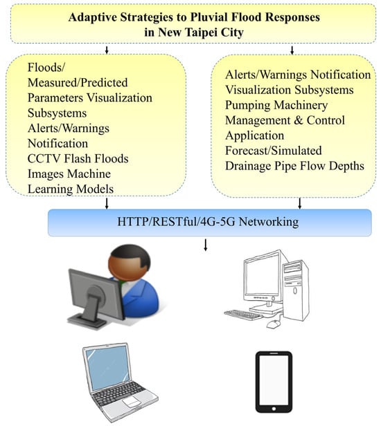
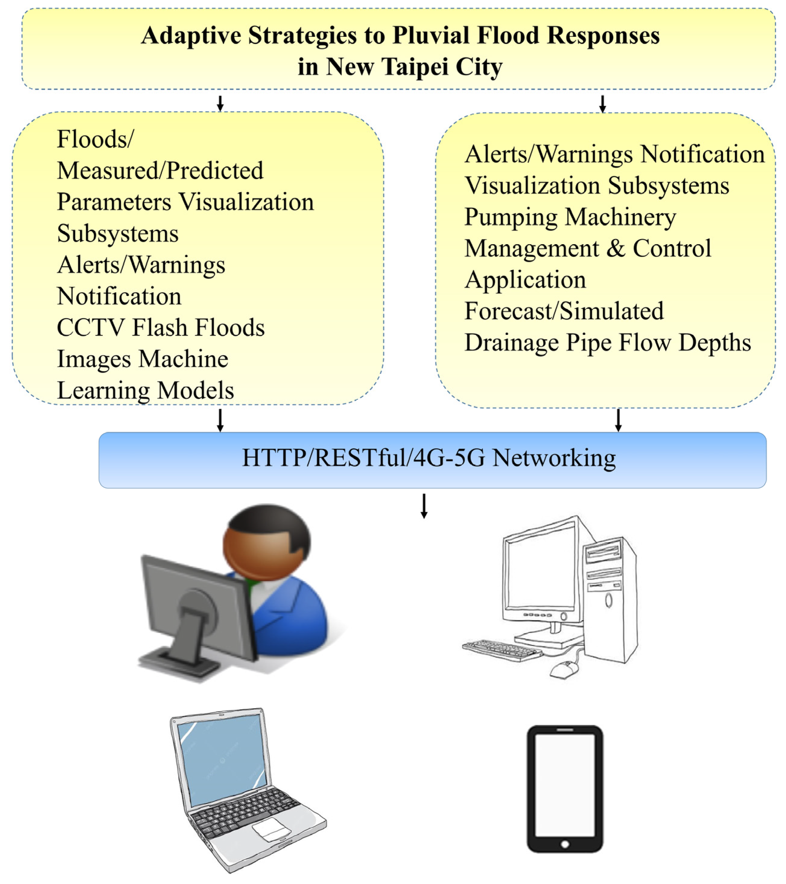
The study implements an ensemble of technical solutions: (1) machine learning-based flood image classification using Closed-Circuit Television (CCTV) feeds [13]; (2) a real-time, multi-layered autonomous pumping control and management system [14,15,16], and (3) SOBEK-based hydraulic modeling [17] for predicting drainage pipe flow depths and identifying potential flash flood events in New Taipei City. The overall architecture of the study is presented in Figure 1. The adaptive approaches and deployed techniques are detailed in the subsequent sections.
Figure 1.
Overall architecture of the study.
2. Methodologies and Implementation
As indicated previously, the study aims to remotely investigate potential methodologies, i.e., flooding image classification, to mitigate the effects of extreme rainfalls and their influence on the drainage infrastructure in New Taipei City in real-time [18].
2.1. Flooding Image Classification Approach
The Convolutional Neural Network (CNN) is one of the most powerful and widely used deep learning architectures, known for its ability to automatically and accurately classify images. This study focuses on leveraging CNN models to classify CCTV images, specifically aiming to detect urban flash floods. By analyzing the features within an image, the CNN models determine whether flooding has occurred [18,19,20,21,22,23,24,25,26].
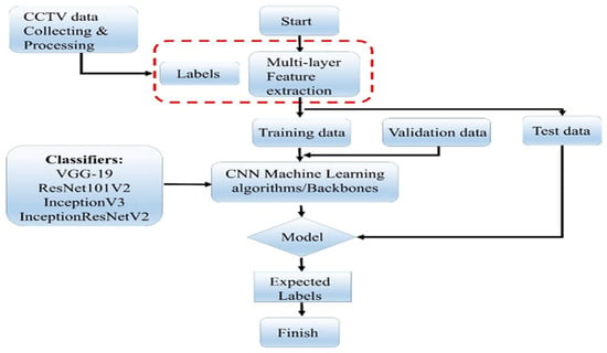
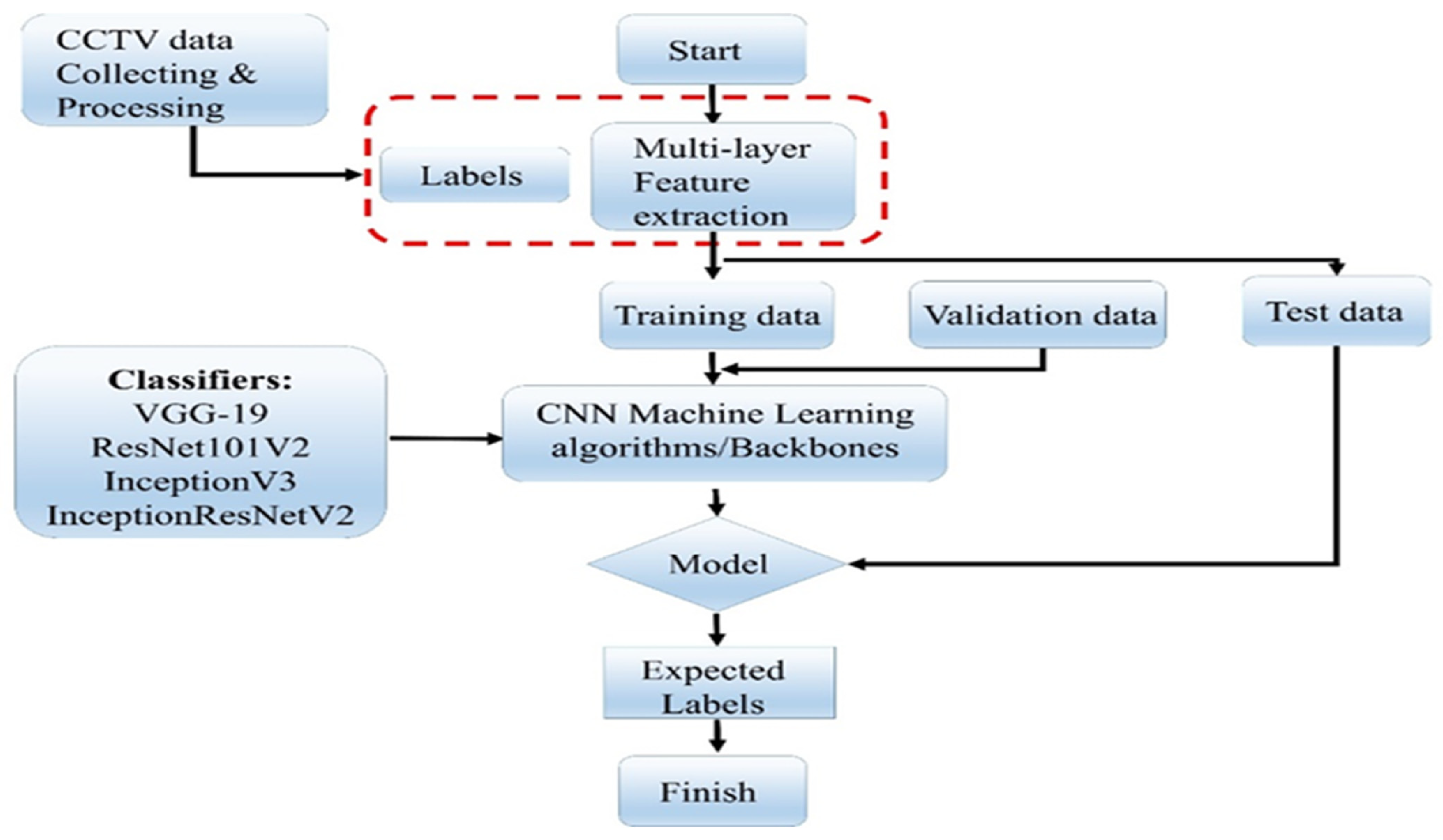
The study was carried out by aggregating CCTV videos from the Department of Transportation, New Taipei City, and later converting them into individual images with the assistance of the members of the Disaster Prevention and Water Environment Research Center (DPWE), National Yang-Ming Chiao-Tung University. The image classifiers rely on pre-trained Convolutional Neural Networks with specified backbones, including VGG19, Resnet-101V2, InceptionV3, and InceptionResnetV2, which adapt hyperparameters as indicated in Figure 2 [27,28,29,30].
Figure 2.
CNN flooding image classification methodologies.
2.1.1. Computer Platform and Environment Configuration
In this experiment, CNN training was performed on the software and hardware platforms detailed in Table 1. The system configuration includes specifications for the operating system, processor, memory, and programming environment used during the experiment.
Table 1.
Device specifications for training CNN backbone.
The CNN model training process involves several key steps. It begins with dataset preparation, followed by the selection of suitable backbone architectures for image classification. Hyperparameters are then fine-tuned to optimize performance. Lastly, the results are analyzed, emphasizing important metrics such as accuracy and generalization [31,32].
2.1.2. Datasets Preparation
The first and most essential step in the CNN training process is dataset preparation, which involves gathering a comprehensive collection of images with corresponding labels. As introduced previously, the experiment utilized a dataset of 15,662 images derived from the Department of Transportation CCTV videos. Members of the Research Center preprocessed these videos into individual labeled images. During data preprocessing, outliers or anomalies in CCTV images were manually detected and removed. This process identifies image regions that deviate from expected patterns or predefined classes [33].
The dataset was designed to capture a diverse range of environmental and lighting conditions relevant to flash flood detection, comprising six distinct image categories, as presented in Table 2.
Table 2.
Six distinct image categories.
This diversity enables the CNN to learn robust features for flood detection across different scenarios and times of day. The dataset was split into training, validation, and testing sets, with 80% (12,580 images) allocated for training, 10% (1529 images) for validation, and 10% (1553 images) for testing. All images were resized to 150 × 150 pixels to standardize input size, ensuring compatibility with the CNN architecture and reducing computational complexity. To mitigate overfitting and increase dataset diversity, data augmentation techniques like 45-degree rotations and horizontal flips were applied, enhancing image variety during training.
2.1.3. Tuning Model Configuration
After preparing the dataset, the next step involved configuring and fine-tuning the CNN models. This study evaluated several well-established CNN architectures, including VGG-19, ResNet101v2, InceptionV3, and InceptionResNetV2. The features of these backbone models are illustrated in Table 3, i.e., CNN model backbones [34,35]. These models, pre-trained on large datasets like ImageNet, offer a robust foundation for transfer learning, enabling fine-tuning for the flood detection task.
Table 3.
CNN model backbones, features, and impact.
To ensure a fair comparison among the CNN models, consistent hyperparameters were applied across all architectures. The fine-tuning hyperparameters used during training are summarized below with further illustrations: (1) optimizer: Adam, (2) number of epochs: 30, (3) dropout probability: 0.4, (4) pre-trained weights: True (ImageNet), (5) learning rate: 0.0001, (6) batch size: 32, and (7) early stopping: False.
- (1)
- Pre-trained models leverage knowledge from large datasets (e.g., ImageNet), providing strong initialization, faster convergence, and improved performance on flood detection tasks, especially with limited data.
- (2)
- The Adam optimizer is selected for its adaptive learning rate adjustment, enhancing convergence speed and robustness in training deep networks.
- (3)
- Setting 30 epochs balances sufficient training time to learn meaningful features and prevents overfitting while allowing performance monitoring via validation loss.
- (4)
- A dropout rate of 0.4 mitigates overfitting by randomly deactivating 40% of neurons during training, encouraging the network to learn robust features.
- (5)
- A learning rate of 0.0001 ensures controlled convergence, avoiding overshooting while fine-tuning pre-trained models by enabling gradual weight updates.
- (6)
- A batch size of 32 balances memory efficiency and convergence stability, providing accurate gradient estimation within memory constraints.
- (7)
- No early stopping is used, allowing models to train fully across all epochs for comprehensive performance evaluation and future adjustments.
2.2. Pumping Machinery Approach
To prompt a response to the pluvial flood impacts, reducing the magnitude of peak flows in affected catchments is crucial. Therefore, a pumping machinery cyberinfrastructure application is established. This study focuses on developing a real-time solution by integrating Artificial Intelligence with Smart IoT devices to control peak flows proactively [1,4].
2.2.1. Pumping Machinery Application/Service
The pumping machinery control and management application is deployed and implemented as a Service (or a Program) in an Application Server on the Platform [11]. It utilizes the IoT sensors/gateway components, device interfaces, protocol stacks, and loosely coupled communication mechanisms among the modules that are provided by the Platform. In addition, the Program includes a location-based service integrating Global Positioning System (GPS) satellites, cellular tower pings, and short-range positioning beacons to provide dynamic allocation of pumping machinery’s geographical location. Employing these methods, the pumping machinery application can dynamically locate, allocate, and operate static/mobile pumping machines in real-time. Furthermore, the application also involves value-added services, for example, emergency routing instructions or consultation for evacuation during flood (or warning) incidents.
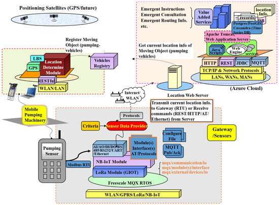
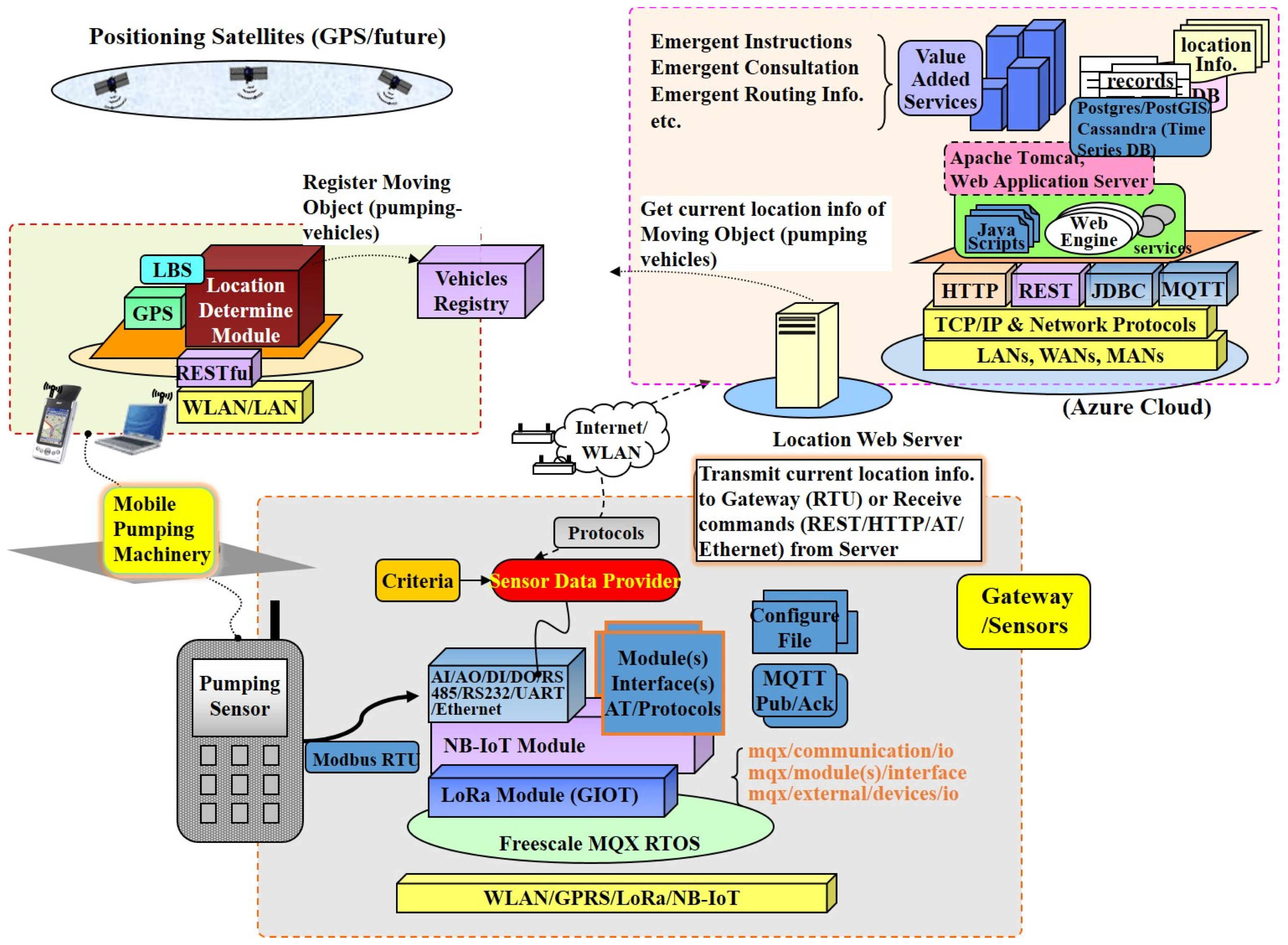
The Service contains front-end sensors, an embedded gateway system, a back-end data center, and a communication mechanism including protocol stacks and message exchange among the involved components, as depicted in Figure 3. The concepts and technologies applying to the Service are demonstrated and illustrated as follows:
Figure 3.
Pumping machinery control and management application architecture and components.
In the diagram, the GPS, via cell phone or satellite, accesses the location-based service to register and track the pumping machinery’s (equipment’s) location. The IoT gateway contains multiple communication capabilities with the back-end server or data center. The gateway can include a LoRa communication module [36,37] and/or an NB-IoT module [38] depending on the gateway, i.e., an embedded microcontroller, available communication interfaces/pins, and communication protocol(s). If the microcontroller communication pins are sufficient, the gateway can include both LoRa and NB-IoT modules. The communication protocols of the modules follow the data format of LoRa standard or/and NB-IoT AT commands via Ethernet UDP socket APIs. Occasionally, the LoRa-enabled module is integrated into a gateway to provide low-power, long-range data transmission across the network to accommodate environmental limitations in the field.
In summary, the New Taipei City pumping machine control and management application (or Service) encompasses three modules: (1) the pumping machine location identification module based upon cell phone GPS-tracking capabilities; (2) surface runoff water level monitoring IoT module including LoRa-based (and/or NB-IoT) Data Logger/Gateway integrated with multisensory detection of pipe flow depths in the drainage networks; (3) the aggregated data of pipe flow depths are propagated to the Data Center, i.e., Azure Clouds; and (4) clients apply RESTful (HTTP) [39,40] web service requests/responses to obtain the data from the Data Center. The sensors monitoring pipe flow depths in stormwater/rainwater drainage networks are installed at the entrances of manholes.
2.2.2. Simulation Modeling of Drainage Network Pipeline Water Depth
This study employs SOBEK (including a hydrological–hydraulic model) to simulate urban drainage flow in a district of New Taipei City. Rainwater is collected through roadside ditches and conveyed into the stormwater drainage system via connecting pipes. Model parameters are defined based on local drainage characteristics, including permeable and impermeable surfaces (e.g., rooftops, pavements, slopes), with rainfall–runoff delay incorporated into runoff volume estimation.
The model couples hydrological and hydraulic components—such as rivers, rainwater sewers, ditches, gates, and pumps—to simulate and forecast drainage water levels, which are linked to alert thresholds for pumping station operations. Catchment areas and surface characteristics are derived from land-use and Geographic Information Systems (GIS) data at the block scale.
This AI-based stormwater simulation platform is designed to represent the short concentration time and operational characteristics of urban drainage systems. Water-level data collected from roadside ditches near stormwater inlets are used as inputs to the SOBEK hydrodynamic model, which generates both historical and forecasted water-level trends for real-time flood management. The downstream boundary condition is defined using observed water levels from the Tamsui River system, while the upstream boundary condition incorporates rainfall inputs that combine six-hour observed precipitation with one-hour QPESUMS rainfall forecasts [11].
To address rainfall uncertainty, 200 stochastic rainfall scenarios are generated based on historical two-dimensional rainfall distributions, including short-duration, high-intensity events [41,42]. Model calibration is conducted by comparing simulated and observed water levels to improve forecast accuracy and establish operational warning thresholds. Water-level forecasts are updated at 10 min intervals and delivered via an application programming interface (API), with results visualized on a real-time monitoring platform. The simulation outputs are further integrated into the Smart Flood Prevention Platform for the New Taipei City case study to support real-time decision-making.
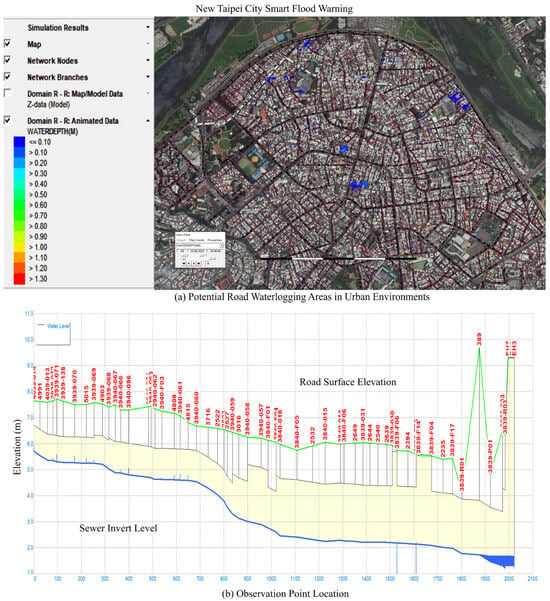
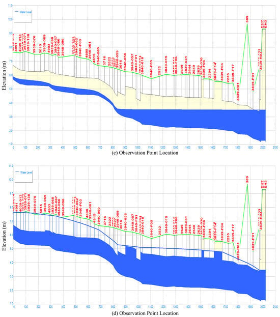
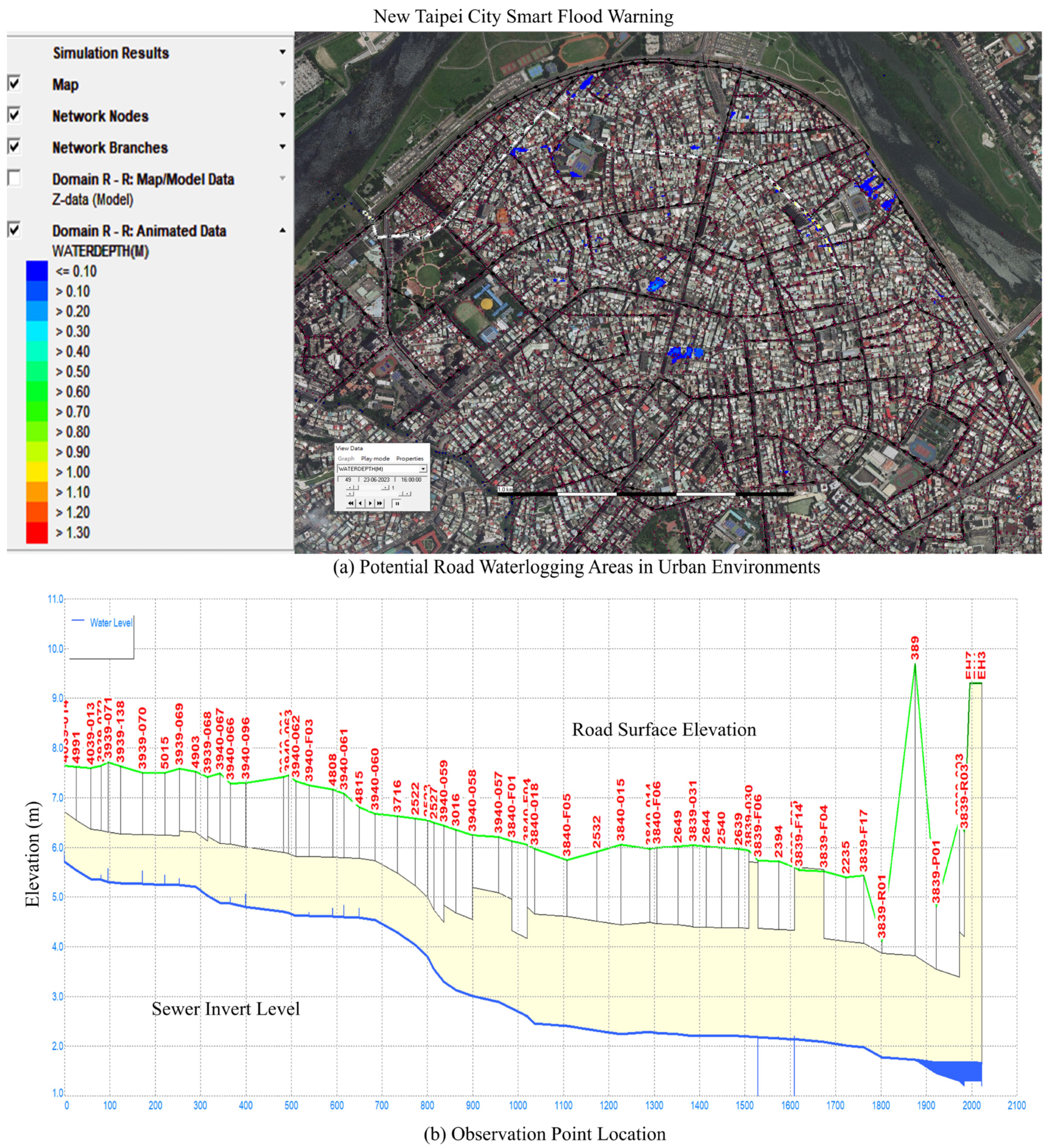
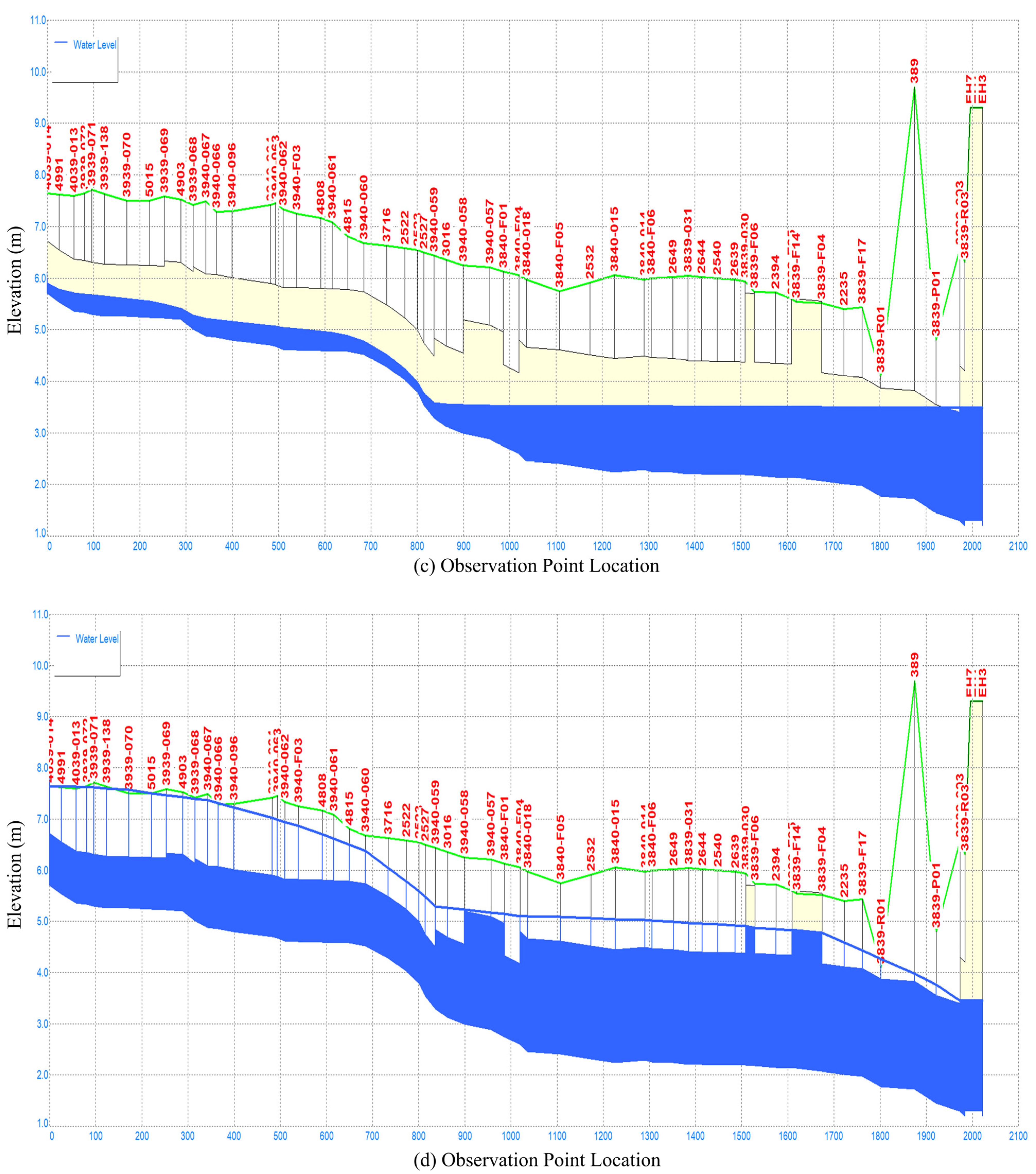
Figure 4a–d illustrate the SOBEK-simulated and forecasted drainage pipe flow depths under different rainfall scenarios in Yonghe District, New Taipei City. Figure 4a shows the subsurface drainage network, with the white line indicating the pipeline segment selected for water depth simulation. Figure 4b demonstrates the effect of pre-draining the network six hours before rainfall, which increases the system’s detention capacity and enhances flood response efficiency. Figure 4c presents the simulated pipe flow depths under a normal rainfall scenario, while Figure 4d displays that, under an extreme rainfall scenario, pump activation is triggered once the simulated water level reaches the critical threshold.
Figure 4.
(a–d) Subsurface drainage networks and simulated pipe flow depths under varying rainfall scenarios.
2.2.3. Artificial Intelligence Algorithm for Controlling Pumping Machinery Operations
The strategy for managing, maintaining, and operating the multi-layer pumping machinery application is straightforward. It follows a “centralized management and decentralized control” mechanism. The Platform centralizes the management of the pumping machinery, and the individual affected regions decentralize the control of pumping equipment allocation and operating. This approach has proven to be both effective and efficient in the field of automation and control [14].
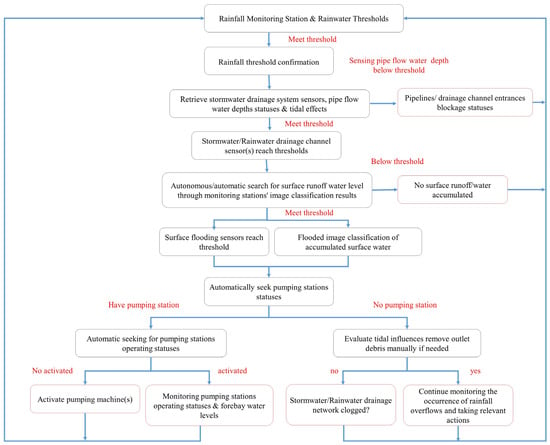
The automated pumping machinery and AI-based algorithms, including various scenarios, are described as follows:
- (1)
- The rainfalls, collected from rainfall monitoring stations or rain gauges, and the flood warning thresholds are the two inputs into the pumping machinery application/service initially.
- (2)
- The pumping machinery application was developed as an autonomous service that integrates ensemble techniques [7] to remotely manage pumping machine operation. It automatically retrieves relevant surface water levels and nearby CCTV images, if available. In essence, the application utilizes four parameters—rainfalls, thresholds, surface water levels, and CCTV video images—to predict, control, distribute, allocate, and operate pumping machinery both statically and dynamically in flood-prone regions in real time.“Note: Cases of extremely severe flooding are excluded from the scope of this study.”
- (3)
- If the stormwater/rainwater pipe is located at an outlet, normally towards the very end of a drainage network, i.e., at the conjunction of either a river system or an ocean, the application checks and evaluates the tidal reach influences.
- (i)
- If not affected by tidal effects, the application will move on to step (4).
- (ii)
- If affected by tidal effects, the application automatically indicates that the blockage statuses of the outlets should be checked; if the outlet is clogged, workers need to remove the debris manually in order to maintain, advance, and accelerate pipe flow at the conjunction smoothly. The program will then move forward to the next step, i.e., step (4).
- (4)
- If there is no surface runoff, the surface water level is not over the value of the flooding warning threshold. It indicates that either the weather is stable, no precipitation is over the catchment, or that the pumping machinery in the region has been running normally; there is no flooding incidence or potential flooding occurrence in the near future. The program iterates back to step (4). The application continues monitoring the pipe flow depths from the sensors as well.
- (5)
- If there is surface runoff, then the surface water level is over the value of the flooding warning threshold, and the application will automatically retrieve the pipe/channel flow depths from the sensors in the stormwater/rainwater drainage networks. The sensors are installed at the manhole of the drainage system in order to monitor the flow depths in the pipes. The pipe flow depths are calculated according to the Manning Equation [43] for partially full pipe flow with pipe parameters, e.g., pipe diameter and constructed material coefficient.
- (i)
- If the pipe flow depth is less than half full, the application automatically indicates that the blockage statuses at the entrance(s) of stormwater/rainwater drainage systems should be checked; if the entrance is clogged, workers need to remove the debris manually in order to maintain, advance, and accelerate street streams into the drainage network smoothly. The program iterates to step (4).
- (ii)
- If the pipe flow depth is half full or higher, the application will automatically identify the designated locations of pumping machinery in the potential flood zones. The additional mobile pumping machines need to be positioned or moved to the designated locations manually. The program will activate both static and mobile pumping machinery and start pumping operations remotely. The program iterates back to step (4).
- (iii)
- If the pipe flow depth reaches 2/3 full or over, the program will issue emergent activities to allocate and activate both static and mobile pumping machinery and start pumping operations immediately. The program iterates back to step (4).
- (iv)
- If the pipe flow depth reaches full, the program checks and evaluates tidal reach inferences:
- (a)
- If not affected by tidal effects, the application automatically indicates to check the blockage status of the outlet of stormwater/rainwater drainage systems at the conjunction of river systems or an ocean; if the outlet is clogged, workers need to remove the debris manually in order to maintain, advance and accelerate the drainage network flows smoothly into the river or the ocean. The program will iterate to step (4).
- (b)
- If flooded and affected by tidal effects, the program will issue emergent activities to allocate and activate both static and mobile pumping machinery and start pumping operations immediately. The program iterates back to step (4).
- (6)
- If there is surface runoff, and the street/surface water level does not reach the values of the flooding warning thresholds, the application automatically indicates that the blockage statuses of the entrance(s) of stormwater/rainwater drainage systems should be checked. If the entrance is clogged, workers need to remove the debris manually in order to maintain surface water flows into the drainage networks smoothly. The program iterates back to step (4).
- (7)
- If an area is flooded according to CCTV image classification, sensors’ water levels in the stormwater/rainwater drainage system must be retrieved and checked; if sensors show high water levels, the application will automatically seek pumping stations’ locations and their operating statuses; if a pumping machine is nearby, and it is inactive, the application will activate the pumping machinery and start a pumping operation; otherwise, it will maintain and continue machineries’ pumping operations. Afterwards, the program will iterate back to step (4).If an area is flooded and the sensors show low water levels, it indicates that the drainage system may be blocked with debris. The application automatically indicates that the blockage statuses at the entrance(s) of stormwater/rainwater drainage systems should be checked. If the entrance is clogged, workers need to remove the debris manually in order to maintain surface water flows into the drainage networks smoothly. The program iterates back to step (4).
The intelligent algorithms of pump operations and scenarios are summarized in Figure 5.
Figure 5.
Summary of intelligent pump operating algorithms and associated scenarios.
Sensors used to monitor pipe flow depths within stormwater/rainwater drainage networks are typically installed at the inlets of manholes. These sensors estimate flow depth for partially filled conduits based on the Manning equation, incorporating two principal parameters: (1) pipe diameter (m) and (2) a concrete–steel roughness coefficient of 0.011. Under low-flow conditions, monitoring data are transmitted at 10 min intervals. As flow depth increases, the transmission frequency is automatically elevated to one-minute intervals to ensure prompt detection and response to hydrodynamic variations. This adaptive transmission strategy facilitates the continuous operation of pumping systems and enables the pre-emptive activation of standby machinery. When floodplain sluice gates are closed, the standby units respond immediately, initiating pumping operations. Consequently, the urban stormwater drainage network functions temporarily as a detention basin, accommodating excess runoff and thereby mitigating the risk of surface flooding in New Taipei City.
3. Results
In response to the growing uncertainty of extreme rainfall events driven by climate change, this study integrates machine learning-based CCTV image classification for real-time surface flood detection with adaptive subsurface drainage pipeline depth prediction and pumping equipment operations. The proposed approach aims to enhance urban flood resilience through intelligent monitoring and dynamic system management. The corresponding results and discussions are illustrated in the subsequent sections.
3.1. Machine Learning Results
The outcomes of the CCTV-based image classification, along with a user-friendly interactive application developed for image dataset visualization, analysis, and prediction, are presented in the following sections.
3.1.1. CCTV Flood Detection Application with Web Interactive Accessibilities
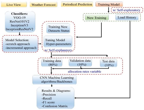
Real-time access to environmental visuals is a key component of flood monitoring. This study developed a user-friendly desktop-based flood detection application [11] with interactive accessibility. The application encompasses four modules: (1) live view; (2) weather forecast; (3) periodical prediction, and (4) training model, as presented in Figure 6. These real-time items and the live camera views provide immediate insights into current conditions, such as surface runoff water levels, weather conditions, and other critical flood indicators, particularly in flood-prone areas. Moreover, the application continuously integrates newly collected datasets into trained CNN models to improve prediction accuracy. Therefore, the application provides real-time road conditions and updates to assist in preventing traffic congestion and supports proactive decision-making while flooding occurs [19,24,44].
Figure 6.
CNN model flood detection application and its operational flow chart.
In Figure 6, the operational procedures of the application are illustrated as a flow chart. It includes the key features of the application and its access to control flows.
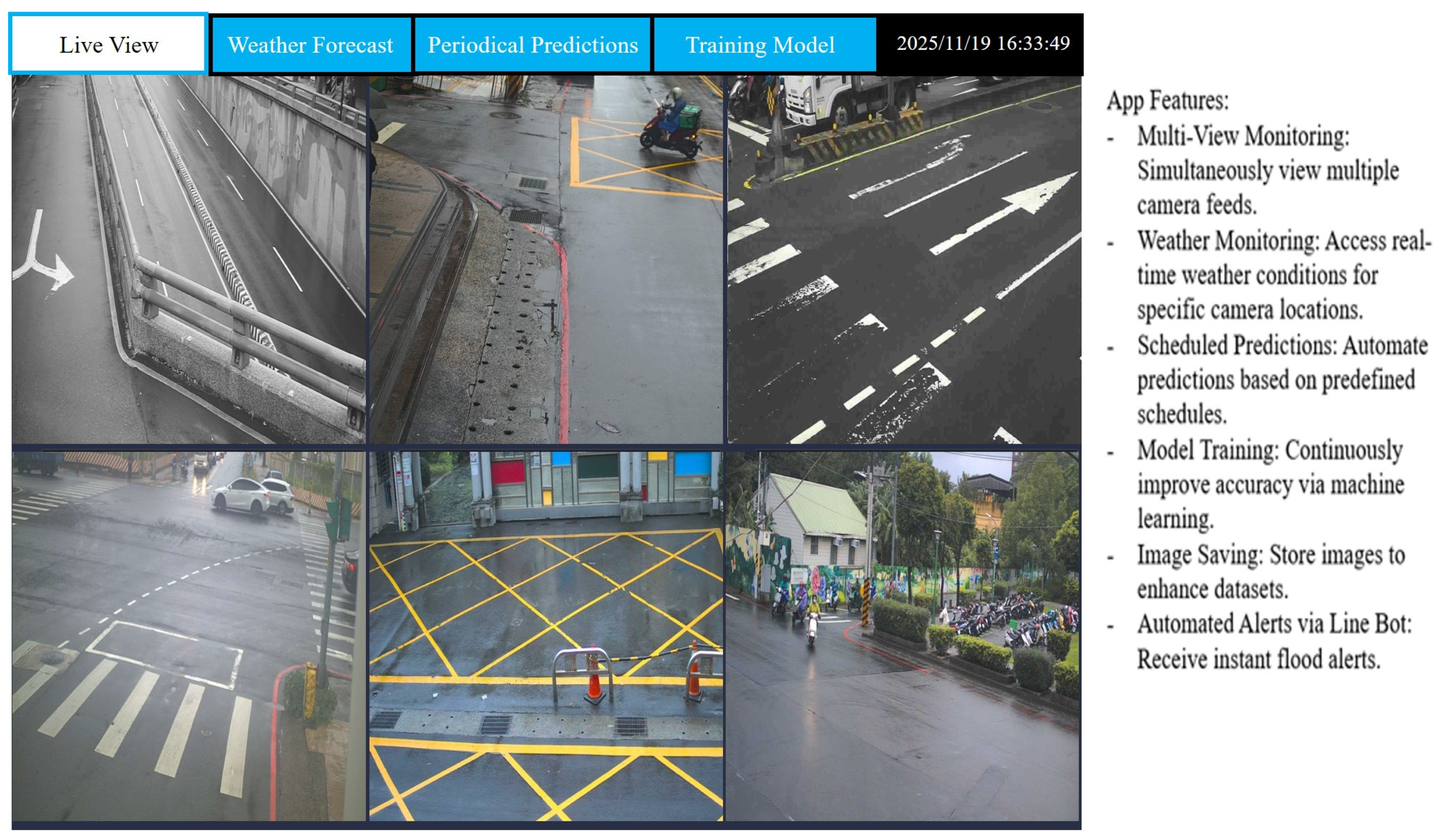
- Live View: Simultaneously viewing multiple camera feeds in real-time, as indicated in Figure 7.
Users can view up to six camera feeds simultaneously and switch between feeds by selecting an available address from a combo box in each view. To ensure smooth performance, the application employs separate threads to handle each camera feed, preventing interference between streams.
Figure 7.
Real-time CCTV monitoring with support for up to 6 channels.
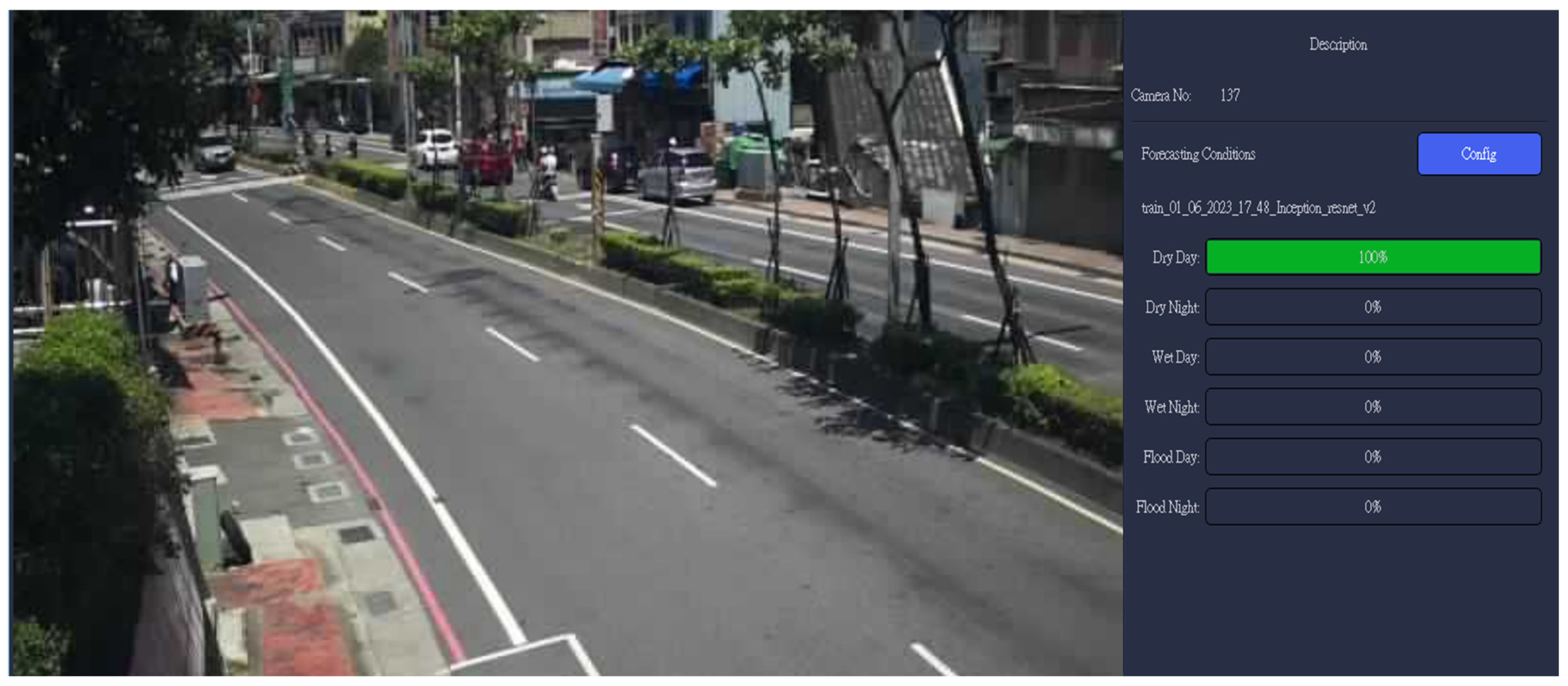
- Weather Forecast: This module provides real-time weather predictions using six classified image categories (see Section 2.1.2, Dataset Preparation) derived from CCTV imagery at a specified camera location, as illustrated in Figure 8. After model training, validation, and testing, the developed models are deployed to perform real-time inference on newly aggregated CCTV datasets at selected locations. Once a location is specified, the prediction process runs continuously, with results displayed on the right-hand side of Figure 8. The interface presents the predicted weather conditions across six categories in percentage terms. In the example shown, the predicted weather at the selected location is classified as dry and daytime.
Figure 8.
Real-time weather forecast presented in six categories at a specified location.
- Periodical Predictions: Automated daily flood predictions can be scheduled using a manually defined timer. The application allows users to configure periodic flood prediction tasks and adjust the corresponding hyperparameters to run image datasets classification automatically according to a predefined schedule.
- Training Model: Model accuracy is continuously improved through machine learning. As shown in Figure 6, the training module provides two primary modes: Load History and New Training. The Load History mode enables users to review previously trained classification models that demonstrated superior performance. This mode also presents key performance metrics, including accuracy, loss per epoch, precision, recall, F1 score, and the confusion matrix, together with the model configuration and corresponding hyperparameter settings.
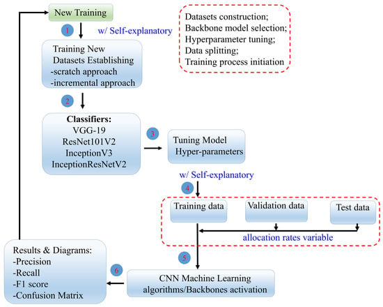
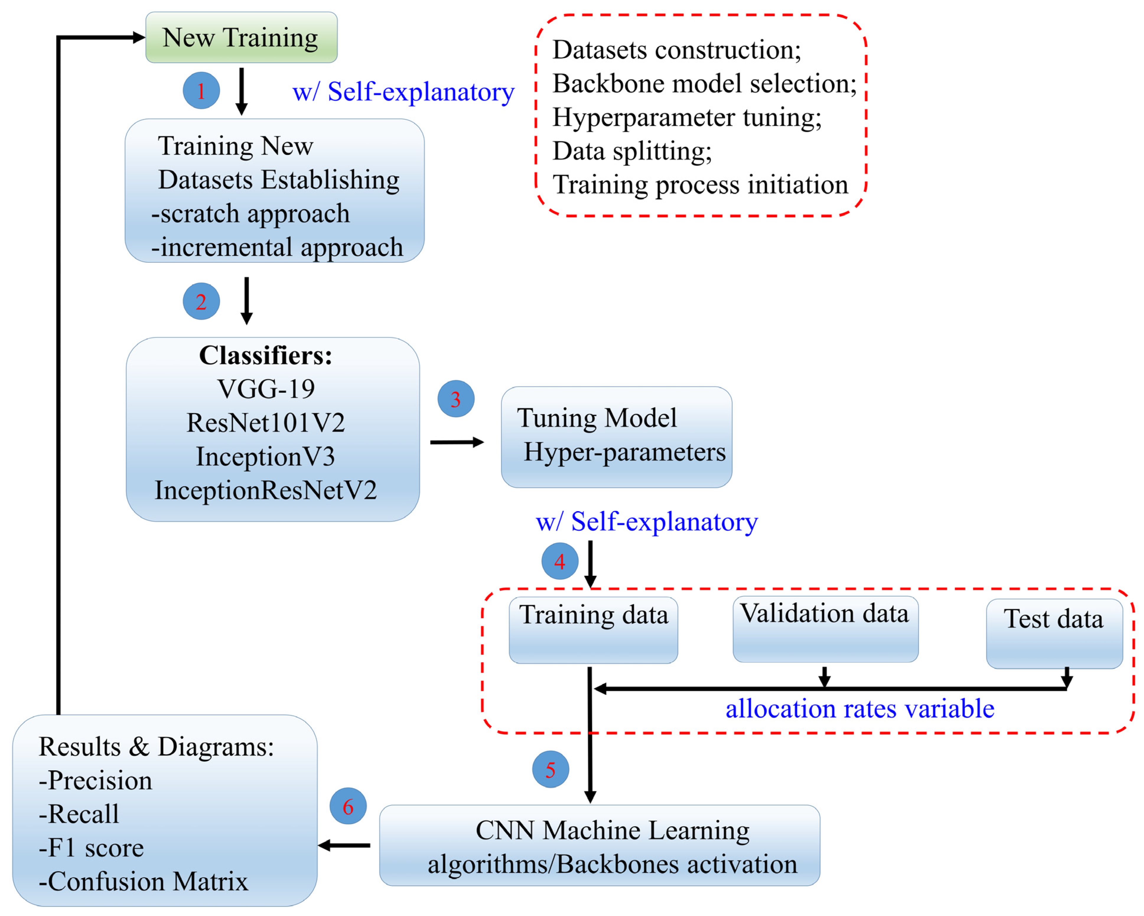
As shown in Figure 9, the New Training mode supports two approaches: (i) training CNN backbone models (e.g., ResNet, VGG19, InceptionNet, and InceptionResNet) from scratch, and (ii) fine-tuning the current best-performing model, such as Inception V3, which demonstrated superior performance in Section 3.1.2, Section 3.1.3 and Section 3.1.4. Both approaches utilize the complete dataset, comprising newly aggregated data and historical records.
Figure 9.
Components and iterative procedures of the New Training mode.
- (1)
- Training CNN backbone models from scratch, as indicated in ① in Figure 9, begins with constructing and categorizing the datasets into six classes. A backbone model is then selected (② in Figure 9), followed by hyperparameter configuration and dataset partitioning for training, validation, and testing (③ and ④ in Figure 9). The training process is subsequently executed (⑤ in Figure 9). For clarity, each step is visually presented in the flood detection application with self-explanatory descriptions. Detailed procedures are described in Section 2.1.2 (Preparing Datasets) and Section 2.1.3 (Training Model Configuration).
- (2)
- The fine-tuning process supports incremental updates using the complete dataset, enabling the model to adapt to evolving environmental conditions and improve prediction accuracy. This workflow is consistent with the New Training mode but is applied to an existing model with previously demonstrated superior performance, such as Inception V3.In this time-stepping data assimilation procedure, each cycle involves comparing the previous model forecast with newly received observations, updating the model state accordingly, and then initiating a new forecast (⑥ in Figure 9).
This flexible design enables users to select optimal modeling strategies according to resource availability and performance goals. The flood detection application includes a dataset collection tool that enhances forecasting accuracy by automatically saving newly captured images during periodic condition assessments. These images are organized into six classes along with their capture dates, enriching the dataset with more diverse samples. As the dataset grows, the model benefits from exposure to varied conditions, leading to improved training accuracy and stronger classification performance. By continuously updating the trained model with new images, the application adapts to changing environmental conditions, thereby delivering more reliable and accurate predictions [45].
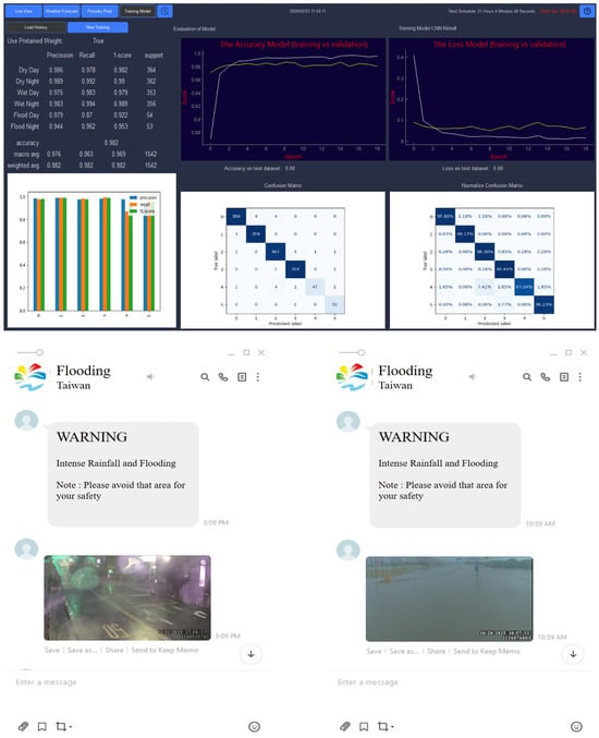
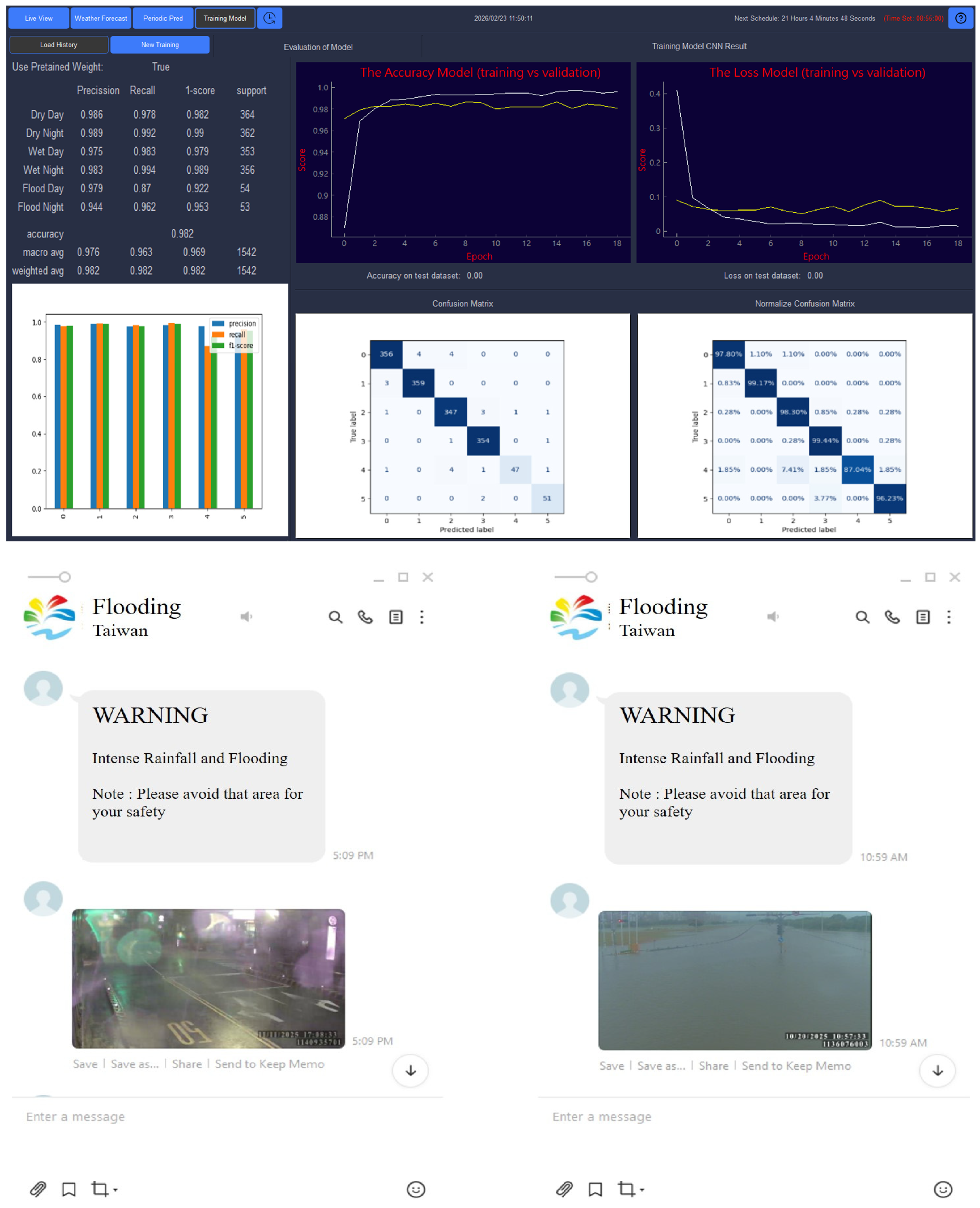
Additionally, the prediction results are seamlessly integrated with the Line API, enabling this social media platform to share real-time information about flood-affected areas, as indicated in Figure 10. It allows people to plan evacuations, take early preventive measures, or avoid traffic disruptions caused by flooding.
Figure 10.
An example of a web interactive flood detection application with automatic line message generation based on predicted results.
3.1.2. Training and Validation Results with Comparison
Following the training of the CNN models on the flood image classification task, the results offered valuable insights into their performance across key metrics, including accuracy, precision, recall, and loss. These metrics were evaluated for both the training and validation datasets, enabling a thorough analysis of each model’s generalization capability.
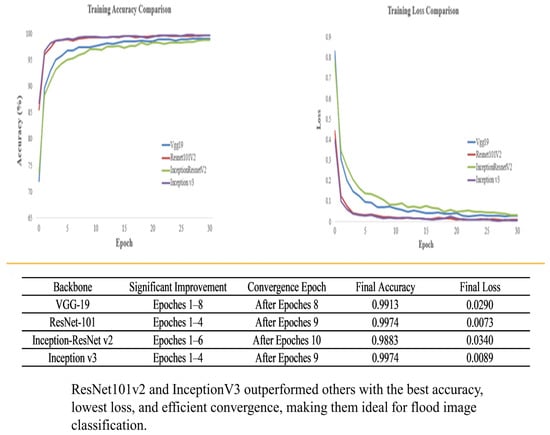
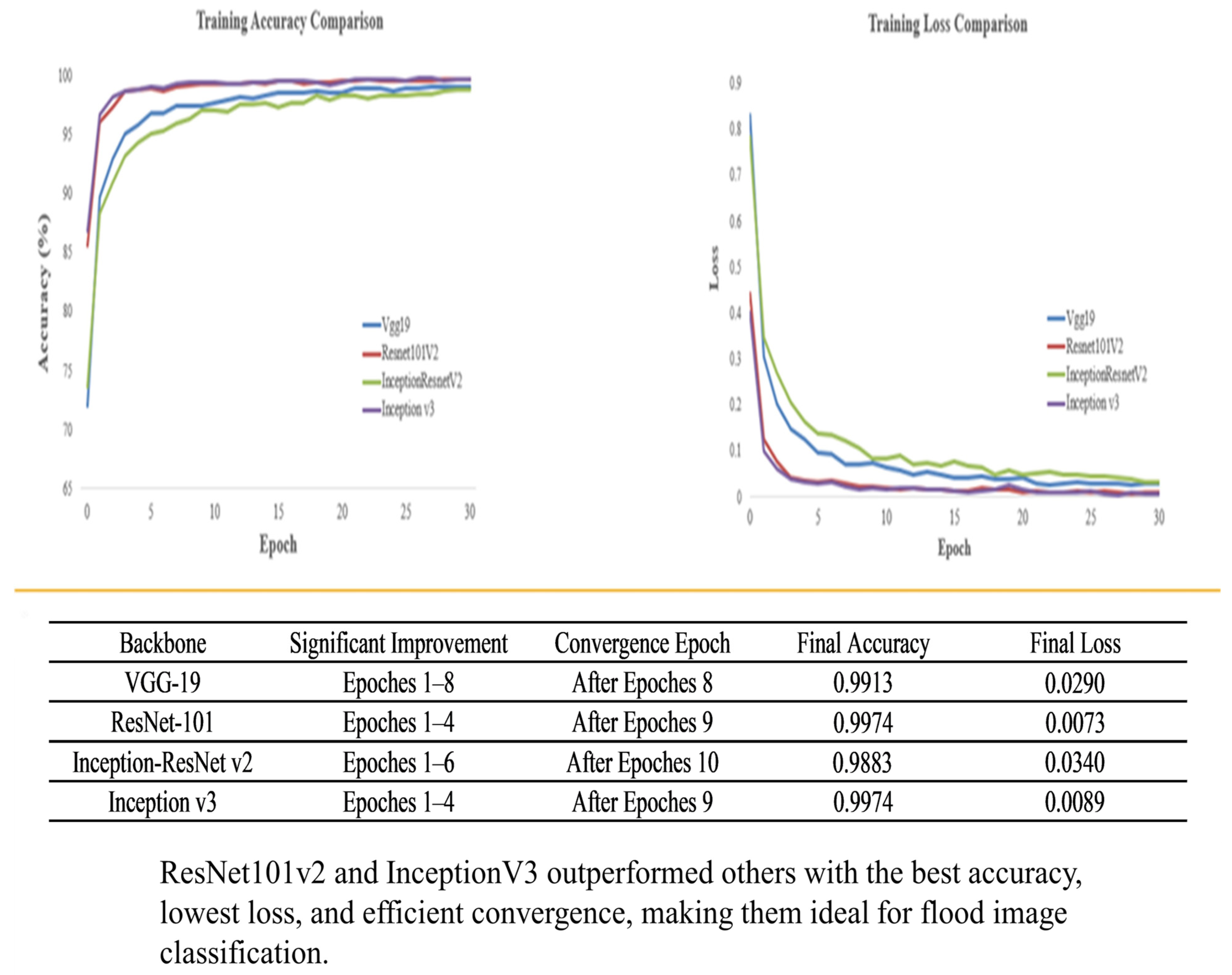
The accuracy and loss curves for each model in the study, along with the training and validation outcomes, are shown in Figure 11. Table 4 summarizes the results for each CNN backbone, highlighting the accuracy and loss rates for both training and validation phases.
Figure 11.
Comparison of training accuracy and loss of the four CNN backbone models in the study.
Table 4.
Classification accuracy and loss of each model.
In the diagram, VGG-19 achieves notable improvements in training accuracy during Epochs 1–8, followed by a slower convergence phase after Epoch 8, culminating in a final accuracy of 99.13%. The training loss steadily decreases, stabilizing at 0.0290, highlighting the model’s slower optimization due to its sequential architecture and high parameter count.
ResNet101V2 demonstrates rapid training accuracy improvement during Epochs 1–4, converging by Epoch 9 with a final accuracy of 99.74%. The training loss declines sharply in the initial epochs and stabilizes at a minimal value of 0.0073. This performance is driven by residual connections, which facilitate efficient gradient flow and enable rapid, stable optimization in the deep network.
InceptionV3 shows rapid accuracy improvement during Epochs 1–4 and converges by Epoch 9, achieving a final accuracy of 99.74%, comparable to ResNet101V2. The training loss decreases sharply and stabilizes at 0.0089, slightly higher than ResNet101V2. Its strong performance is attributed to the Inception module, which enhances feature learning and generalization through multi-scale processing.
InceptionResNetV2 exhibits steady accuracy improvement during Epochs 1–6, converging after Epoch 10 with a final accuracy of 98.83%. The training loss decreases steadily but stabilizes at a higher final loss of 0.0340 compared to other models. This reflects challenges inherent to its hybrid architecture, which integrates Inception modules and residual connections. While this design enhances feature learning, its complexity introduces optimization difficulties. The slower convergence and higher final loss indicate the need for additional training epochs or fine-tuning to fully optimize its parameters.
Table 4 summarizes the classification accuracy and loss of each model. Key observations are that: (1) Inception V3 achieves the highest training and validation accuracy with the lowest loss; (2) VGG-19 allows detailed pattern learning due to its deep, straightforward architecture but is prone to overfitting, limiting generalization; (3) ResNet101V2 uses residual connections to mitigate vanishing gradients, enhancing generalization and outperforming VGG-19 in accuracy and validation loss; (4) Inception V3 captures multi-scale features through Inception modules, demonstrating strong generalization and minimal overfitting; and (5) Inception-ResNetV2 combines Inception modules with residual connections but is challenging to train, showing the highest validation loss among the backbones, suggesting potential overfitting or suboptimal generalization.
In summary, all CNN backbones achieve high accuracy, with Inception V3 performing best. Low loss rates indicate effective learning and limited overfitting, though higher validation losses in VGG-19 and Inception-ResNetV2 highlight the potential for optimization to improve generalization [18,43,46,47].
3.1.3. Training Times of Models
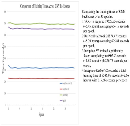
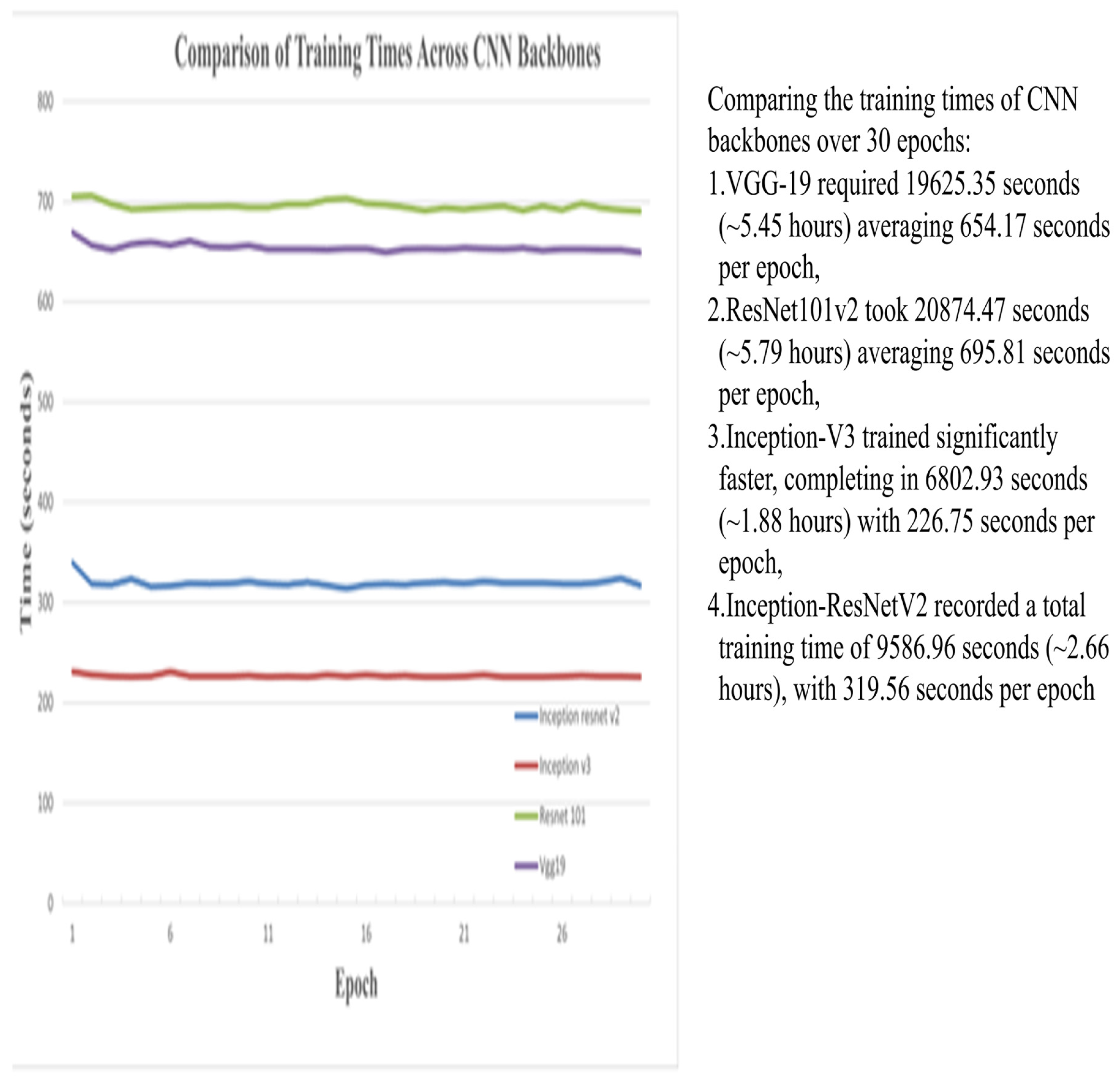
The evaluation compares the training times of CNN backbones over 30 epochs, revealing distinct durations. As indicated in Figure 12, VGG-19 required 19,625.35 s (~5.45 h) with an average of 654.17 s per epoch, while ResNet101v2 took 20,874.47 s (~5.79 h), averaging 695.81 s per epoch. Inception-V3 trained significantly faster, completing in 6802.93 s (~1.88 h) with 226.75 s per epoch. Inception-ResNetV2 recorded a total time of 9586.96 s (~2.66 h), averaging 319.56 s per epoch.
Figure 12.
Comparative analysis of training times for each CNN backbone model.
Overall, InceptionV3 proved to be the most effective model, demonstrating rapid convergence, high accuracy, and low loss, closely followed by ResNet101V2. In contrast, VGG-19 and InceptionResNetV2 faced optimization challenges, evident in their slower convergence and higher loss values. These findings highlight the critical role of model architecture and initialization strategies in achieving optimal training and validation performance [20].
During the training process, each backbone model typically utilized 100% of the system’s CPU and approximately 88% of its memory, with an average training duration of 7–8 min per epoch. However, the ResNet-101v2 model required more time to train due to its increased depth.
Inception-V3 demonstrated the highest training efficiency, followed by Inception-ResNetV2. The longer durations for VGG-19 and ResNet101v2 reflect their higher complexity, highlighting the trade-off between model complexity and training efficiency. Selecting an appropriate backbone depends on project requirements [34,35,41].
3.1.4. Testing Results
The classification performance on the test datasets is evaluated using confusion matrices, highlighting the prediction accuracy across six classes for the specified backbone model. Table 5 summarizes the testing outcomes for each backbone model, including metrics such as accuracy, loss, precision, recall, F1 score, and error analysis.
Table 5.
The summary of testing results for each CNN backbone model.
Table 5 indicates that the Inception V3 backbone achieved the highest performance across all categories, with the lowest loss and error rates. This confirms that the Inception V3 model demonstrates superior accuracy in correctly identifying the target classes.
The findings of the study differ from those reported by Szegedy et al. [48] and He et al. [28]. Their work investigated whether combining the Inception architecture with residual connections offers any performance advantage. They provided clear empirical evidence that incorporating residual connections significantly accelerates the training of Inception networks. Furthermore, their results indicated that residual Inception networks may outperform comparably more complex Inception models without residual connections, albeit by a narrow margin.
3.2. Pumping Machinery Results
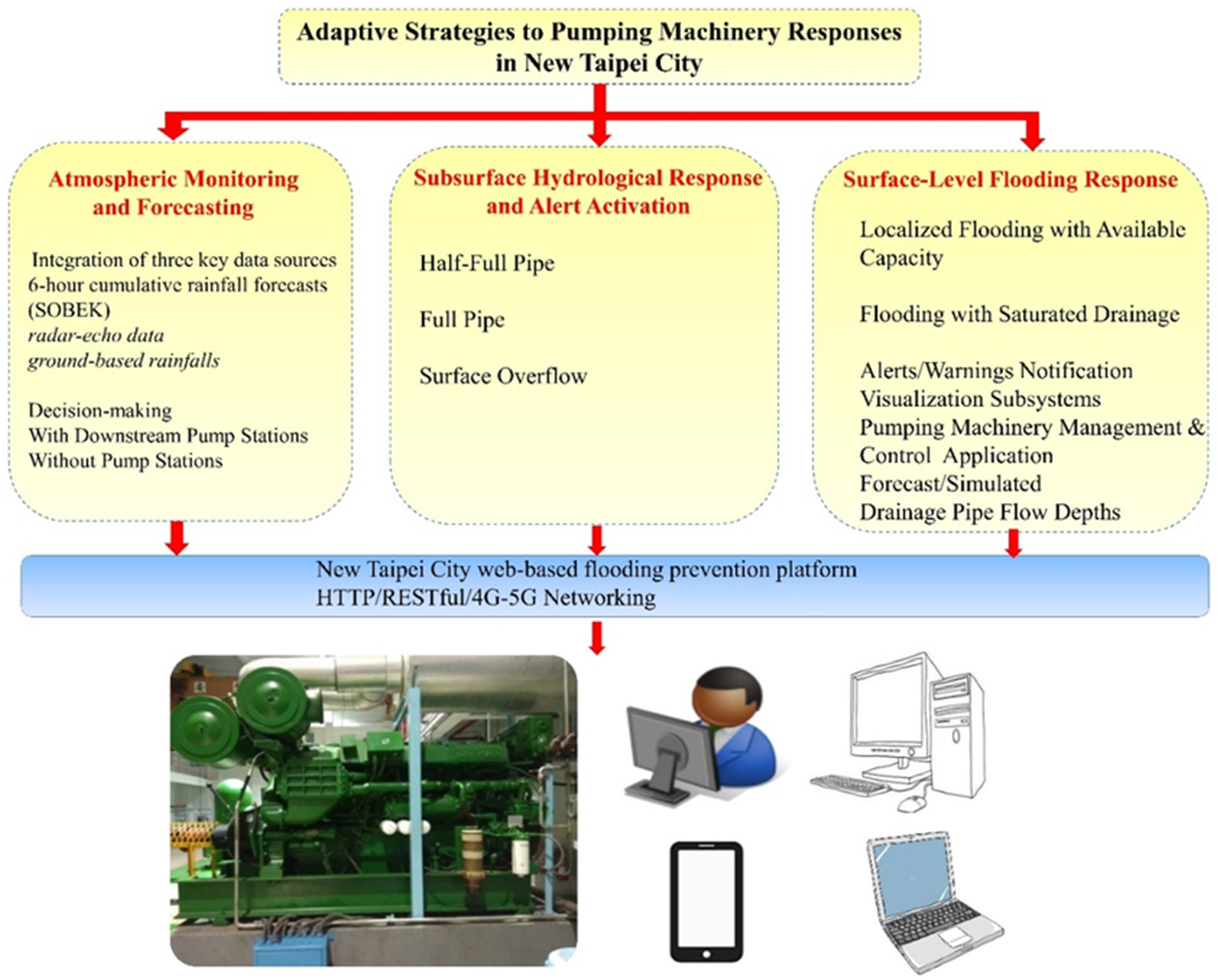
To prevent urban inundation, the adaptive pumping strategy is structured into a three-phase framework that supports real-time decision-making based on rainfall progression and drainage system response. This AI-based approach integrates atmospheric monitoring, subsurface hydrological alerts, and surface flooding assessments, enabling timely and site-specific interventions.
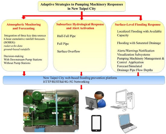
Figure 13 depicts adaptive pumping strategies for New Taipei City flood mitigation. The three phases of operations are illustrated clearly as follows:
Figure 13.
Adaptive pumping strategies for New Taipei City flood mitigation in a three-phase operational framework.
Phase 1: Atmospheric Monitoring and Forecasting
Early rainfall awareness is achieved through the integration of three key data sources: (1) 6 h cumulative rainfall forecasts offer preliminary indications of potential events, (2) radar composite reflectivity enables real-time tracking of large-scale systems (e.g., typhoons, Meiyu fronts), and (3) ground-based rain gauges provide high-resolution precipitation data. Rainfall exceeding 10 mm in 10 min signals heightened alert, while rainfall of >20 mm/10 min—especially in urban or upstream mountainous areas—triggers pumping equipment readiness protocols.
Decision-making diverges by system type:
- With Downstream Pump Stations: Drainage operation is guided by tidal conditions. Rising tides prompt early closure of floodgates and pump activation, converting drainage systems into temporary detention spaces. Falling tides allow gravity drainage system execution.
- Without Pump Stations: Gravity-drained systems rely on real-time water level trends from sensors. If flooding risk is detected, mobile pumps are pre-deployed for rapid response.
This phase is underpinned by automated rolling monitoring updated every 10 min, ensuring near real-time situational awareness.
Phase 2: Subsurface Hydrological Response and Alert Activation
As rainfall transitions to runoff, stormwater enters drainage systems, triggering real-time hydrological monitoring. The urban flash flood management platform with intelligent alerts and warnings for New Taipei City [11] assesses sensor data against predefined thresholds.
Alert levels include:
- Half-Full Pipe: Indicates increasing rainfall intensity. Pump stations are activated, and monitoring frequency is increased to 1 min intervals.
- Full Pipe: Signals pressurized flow; overflow is imminent. Pump stations operate at maximum capacity, or local authorities are notified for field response.
- Surface Overflow: Triggers immediate traffic control for public safety.
In regional drainage channels, alert thresholds prompt pump activation if available. If overtopping is projected or occurs, residents are evacuated to higher ground or upper floors.
Phase 3: Surface-Level Flooding Response
When surface inundation is detected via flood sensors and intersection CCTV cameras, a localized response is coordinated by community leaders. The platform rapidly distinguishes between two scenarios:
- Localized Flooding with Available Capacity: Indicates inlet blockage or temporary accumulation. Water recedes post-rainfall or can be cleared manually.
- Flooding with Saturated Drainage: Confirms system overload. On-site teams manage traffic and report conditions to the platform for system-wide diagnostics.
This three-phase framework provides a scalable, data-driven approach to urban flood management, integrating forecasting, real-time monitoring, and operational response to minimize flood risk and impact.
4. Discussion
In the initial stage, data availability was limited; therefore, the big data framework was primarily constructed using historical records and hydrological model outputs. As field observations and operational experience accumulated, incremental adjustments were introduced to better align the drainage system with real-time conditions and on-site requirements. Through monitoring data and automated data transmission technologies, relevant information is delivered to disaster prevention personnel across the system to support operational decision-making. Furthermore, this adaptive process follows a rolling review mechanism to ensure continuous improvement.
Continuous connectivity and complete data transmission are essential for pumping stations and their associated drainage systems. Therefore, strict regulations are enforced regarding cybersecurity and signal transmission. Monitoring data are recorded at one-minute intervals and, under normal conditions, transmitted in batches of 10 records every 10 min. During rainfall events that reach predefined warning thresholds, data are transmitted every minute. Any interruption or missing data triggers immediate alerts for real-time intervention.
In the early stage of system implementation, CCTV cameras and roadside water-level sensors were primarily deployed at flood-prone, low-lying locations, which may have limited the direct observation of inundation events occurring elsewhere. To address this limitation, the system integrates rainfall and water-level data to infer drainage system conditions and to differentiate between systemic drainage issues and localized obstructions caused by debris, as illustrated in Figure 5. Collaboration with local village leaders and residents facilitates timely field verification and intervention, supporting rapid removal of standing water and adaptive system refinement.
There are uncertainties associated with IoT devices. During heavy rainfall or typhoons, data transmission may be delayed or interrupted, making real-time processing impossible. Human-induced uncertainties, such as vandalism, may also lead to damaged monitoring equipment. This study utilizes surrounding information and radar-echo data to assist in validating and improving data accuracy. Furthermore, during heavy rainfall or typhoons, on-site repairs are generally not possible within 1–6 h (with a target of completing repairs within 24 h), resulting in incomplete information. Backup power systems can only support operations for 6 to 12 h during a power outage. Additionally, 4G/5G network issues cannot be resolved immediately and require repair by telecommunications providers [11].
The study implements an ensemble of technical solutions to identify potential flash flood events: (1) machine learning-based flood image classification using CCTV feeds, and (2) a real-time, multi-layered autonomous pumping equipment control and management system that predicts drainage pipe flow depths. The discussion is structured into two parts, beginning with the machine learning method, followed by the pumping machinery approach.
4.1. Machine Learning Discussion
During experimentation, dataset collection and image classification errors were occasionally observed due to obstructions such as tree leaves, glass reflections, wet surfaces, and image blurriness caused by moisture, which sometimes led to false flood detections. To enhance model robustness, images were collected from diverse scenarios featuring multiple flood-related characteristics, such as vehicle-induced water ripples and raindrop patterns. An iterative refinement process was adopted, in which misclassified or undetected images from each flooding event were incorporated into the training dataset for retraining. This adaptive learning approach progressively improved the model’s recognition accuracy and stability in real-time flood detection applications. In this time-stepping data assimilation procedure [45,49], each cycle involves comparing the previous model forecast with newly received observations, updating the model state accordingly, and then initiating a new forecast.
4.2. Pumping Machinery Discussion
In New Taipei City, a distinctive regional feature of its flood control infrastructure is the widespread installation of sliding floodgates (“horizontal gates”) at low-lying areas and key building entrances. This design is particularly suited to addressing the sudden flooding risks caused by heavy rainfall or typhoons in urban areas. It also takes into account the city’s densely packed spaces and numerous underground facilities, offering a more efficient flood prevention mechanism. These sliding gate systems are often integrated with automated sensors and remote-control functions, enhancing real-time responsiveness. As a result, they have become a unique urban flood prevention strategy in New Taipei City, showcasing a site-specific approach for highly urbanized regions facing extreme climate challenges.
Based on its terrain and urban development characteristics, New Taipei City has established a distributed drainage and pumping network densely across flood-prone hotspots, effectively reducing emergency response time. Particularly along the Tamsui River, Xindian River, and in areas such as Banqiao, Zhonghe, and Sanchong, the city has constructed smart pumping stations equipped with real-time rainfall and water level sensors, as well as electric control systems for automated operation. These stations are integrated into the “New Taipei City Smart Flood Prevention Platform”, allowing for remote monitoring and automatic activation, significantly improving drainage efficiency during short-duration intense rainfall events. Additionally, some pumping stations are combined with retention ponds located in underpasses and low-lying areas, serving dual functions of water detention and pumping. This demonstrates greater resilience and flexibility compared to traditional pumping facilities, making New Taipei City a leading example of smart pumping strategies in Taiwan.
In terms of the drainage system, New Taipei City’s approach involves guiding rainfall from the surface through roadside gutters and connecting pipes into the stormwater drainage network, and ultimately discharging it via pumping stations into the Tamsui River system. Since these pumping stations are affected by the tides of the Tamsui River, a combined floodgate and pump operation system has been developed to coordinate with tidal water levels. This differs from other regions, where rainwater is typically drained directly into rivers via roadside gutters or after passing through the stormwater drainage infrastructure.
Furthermore, New Taipei City implements localized pumping wells to alleviate flooding in low-lying areas. To address frequent water accumulation during sudden heavy rainfall in areas such as Nanzai Ditch, the New Taipei City Water Resources Department has implemented a localized pumping well strategy that enhances drainage through mechanical assistance combined with gravity flow (URL: https://news.ltn.com.tw/news/life/breakingnews/4715776, (accessed on 15 November 2025 in Traditional Chinese)). Three flood-prone sites were each equipped with a pumping well and five mechanical-assisted gravity pumps, providing a total drainage capacity of 1 cms (equivalent to one ton of water per second).
By integrating mechanical pumping with gravity-based drainage, the new system significantly strengthens the city’s flood mitigation capacity and demonstrates an innovative approach to localized stormwater management. In other words, the approach exemplifies the effectiveness of integrating real-time hydrological monitoring, rainfall forecasting, and smart pumping control. Despite rainfall exceeding the stormwater system’s design standard, proactive water-level reduction and timely alerts enabled effective flood mitigation and reduced surface inundation duration.
5. Conclusions
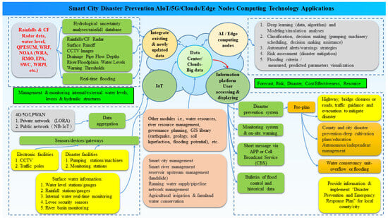
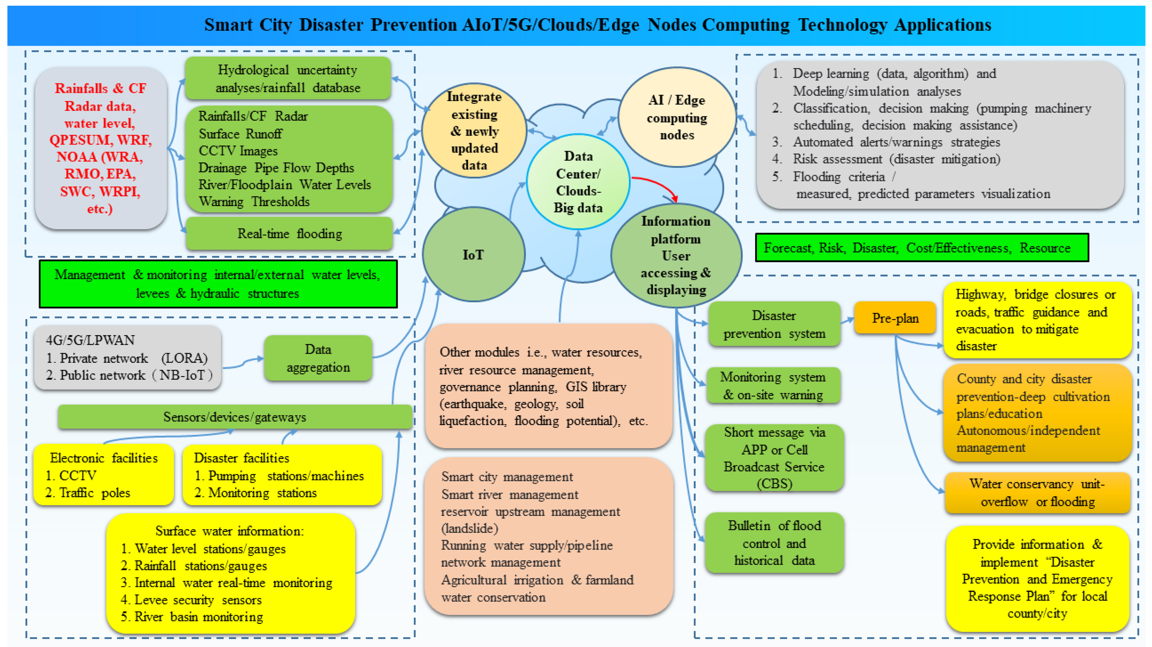
The study develops and deploys an integrated platform for real-time pluvial flood monitoring, prediction, and responses, as summarized in Figure 14. The system comprises five core modules: (a) IoT-based sensing of rainfall, surface runoff, drainage networks, and pumping operations; (b) integration of existing and newly updated datasets, including radar composites and CCTV imagery; (c) AI and edge-computing functions for simulation, prediction, and inundation classification; (d) centralized big-data storage and analytics for hazard assessment at local and island-wide scales; and (e) interactive user interfaces for alerts, decision support, and evacuation guidance. Built on an SOA and AI-IoT technologies interconnected via 4G/5G, the platform supports seamless data aggregation, analysis, and dissemination of real-time hydro-meteorological information.
Figure 14.
Distributed, hierarchical cloud-based infrastructure AI+IoT+SOA+Networking implementation for ecosystem real-time flash flood prediction, prevention, and mitigation involving hydrological/hydraulic domain knowledge.
To enhance flood response efficiency, New Taipei City’s Smart Flood Prevention Platform integrates water-related information systems across municipal agencies. The platform consolidates data from rainfall stations, water-level gauges, drainage sensors, roadside and surface flood sensors, intersection CCTVs, and pumping station operations, providing a comprehensive, unified view of flood conditions.
- Automated real-time CCTV image classification
This module uses predefined or user-configurable parameters to automate the collection, analysis, and visualization of hydrological image datasets for CNN-based training, validation, and prediction. The system provides six-channel CCTV visualization, localized weather information, automated training and inference scheduling, and continuous dataset updates for both full retraining and incremental learning.
For a machine learning experiment, a dataset of 15,662 images was extracted from the Department of Transportation’s CCTV video streams and converted into individual samples by the DPWE team. Image classification models were developed using pre-trained CNN architectures—VGG19, ResNet-101V2, InceptionV3, and InceptionRes-NetV2—configured with the following hyperparameters: Adam optimizer, 30 epochs, dropout rate of 0.4, ImageNet pre-trained weights, learning rate of 0.0001, batch size of 32, and no early stopping.
Among the four models, InceptionV3 exhibited superior performance, achieving the highest values for accuracy, precision, recall, and F1 score. Prior studies similarly indicate that Inception architectures without residual connections can slightly outperform their residual counterparts [27,46], highlighting the value of model simplicity in urban flood-image classification research [19].
For continuous dataset enhancement, the CCTV flood-detection tool incorporates an automated dataset collection mechanism that stores newly captured images by class (six categories) and timestamp during each prediction cycle. This expanding dataset increases model robustness by incorporating diverse environmental conditions, thereby improving training and inference accuracy over time. Continuous updates enable the model to adapt to evolving flood patterns, while flexible configuration settings allow users to select modeling strategies according to resource availability and performance requirements. Additionally, the application automatically uploads potential flood alerts via LINE.
- 2.
- Real-time drainage and pumping system monitoring
This module integrates multi-source information, including drainage-network maps, surface-flooding sensors, pipe-flow depth gauges, rainfall measurements, and pumping station operating status. The SOBEK hydrological model is incorporated to improve downstream flood forecasting and optimize sluicegate operation planning during typhoon events. All information is compiled within an automated interface that provides agencies with real-time references for coordinated flood control.
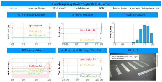
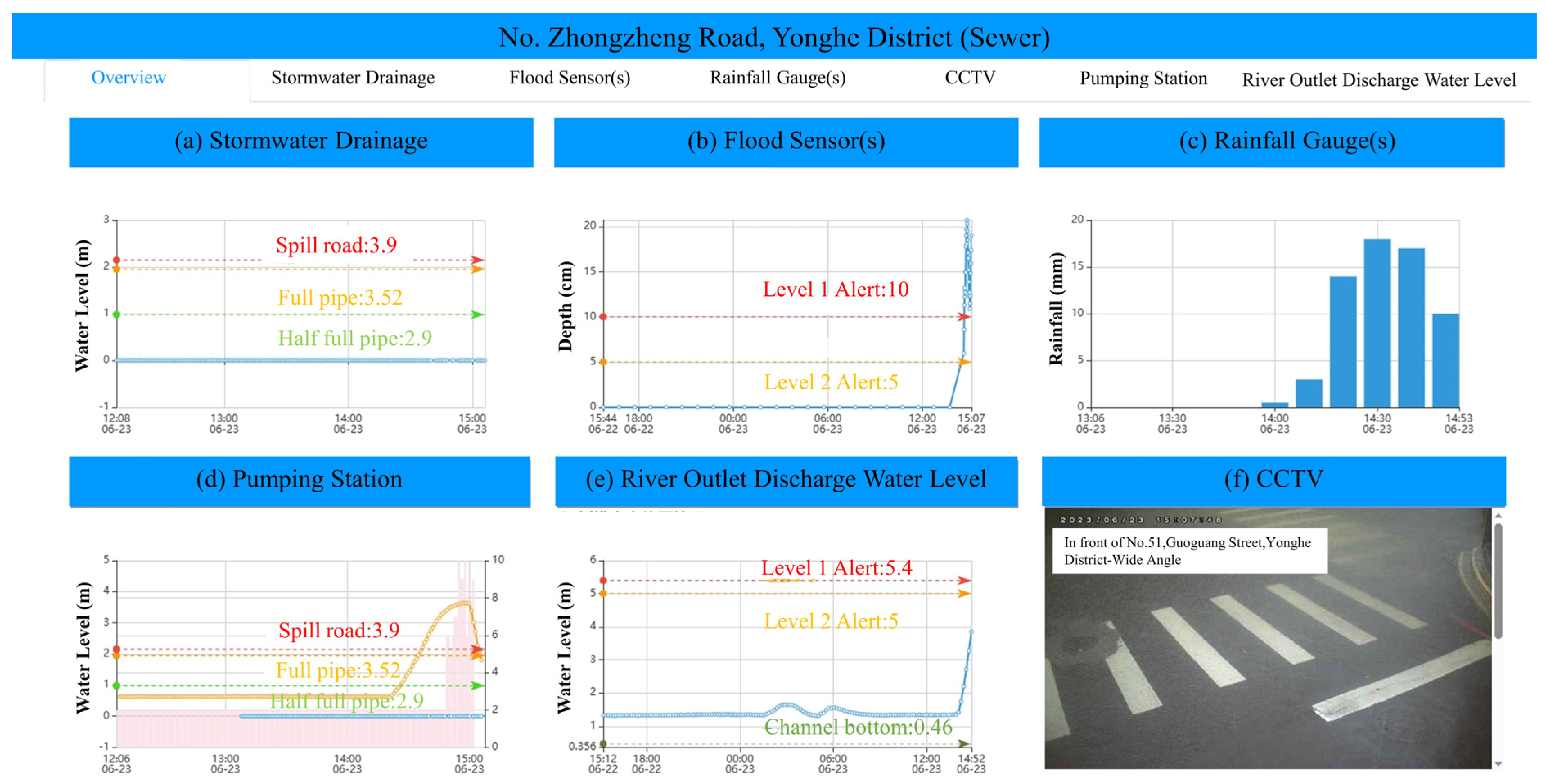
For real-time visualization and decision support, by automating data aggregation and visualization, the framework establishes a continuous, systematic monitoring mechanism that strengthens hydrological situational awareness and improves the timeliness of flood-management decisions. A key feature is the real-time six-panel visualization interface [11], as indicated in Figure 15, which presents essential hydrological and operational information, including: (a) stormwater drainage pipe-flow depths; (b) surface runoff water levels; (c) rainfall histograms; (d) pumping machinery status and forebay water levels; (e) river outlet water levels, and (f) CCTV imagery.
Figure 15.
Six-panel dashboard layouts and real-time adaptive responses.
This intuitive layout enables engineers and decision-makers to rapidly assess rainfall intensity, drainage capacity, surface flooding, and pumping performance, supporting coordinated and effective flood-response operations. This incident highlights the effectiveness of the smart monitoring platform in managing short-duration, high-intensity rainfall. By integrating real-time sensor data into decision-making, the system shortened flood duration and reduced impacts, even under rainfall exceeding the stormwater system’s design standards.
The design and optimization of urban drainage infrastructure that considers climate change impacts and co-optimizes this with other objectives for a habitable city will become increasingly important in the future [5]. In the study, the system enhances disaster preparedness by automating inundation detection through machine-learning-based image classification and optimizing pumping operations to shorten response times and stagger peak flows. Its centralized data infrastructure supports cascading hazard assessment while delivering timely warnings to both authorities and the public. By integrating ensemble modeling, remote sensing, and decision-support tools, the platform transforms climate-induced flood risks into opportunities for resilience.
Urban drainage systems are designed for specific rainfall thresholds; in New Taipei City, the design rainfall intensity is approximately 70–90 mm/60 min. Under United Nations IPCC AR6 climate change scenarios, projected rainfall increases in Taiwan range from 10% to 33%, with an estimated increase of about 20% in New Taipei City, representing near-extreme rainfall conditions. As such increases cannot be addressed through short-term engineering upgrades, the outcomes of the study indicate that, under existing infrastructure constraints, adaptive strategies supported by big data analysis, hydrological simulation, and AI-based tools can effectively suppress disaster occurrence. During a three-year implementation period, the approach successfully resolved inundation events after severe rainfall subsided.
Author Contributions
Conceptualization, S.-H.Y., X.-J.W. and S.-L.H.; methodology, S.-L.H., X.-J.W. and S.-H.Y.; software, S.-L.H. and X.-J.W.; validation, S.-L.H., X.-J.W., M.-S.H., C.-W.C. and S.-H.Y.; writing—original draft preparation, S.-L.H., X.-J.W., D.-L.C. and S.-H.Y.; writing—review and editing, S.-L.H. and D.-L.C.; supervision, S.-H.Y., M.-S.H., C.-W.C., D.-R.S., J.-H.P. and K.-C.Y. All authors have read and agreed to the published version of the manuscript.
Funding
This research received no external funding.
Data Availability Statement
The datasets presented in this article are not readily available because the data are part of an ongoing study. Requests to access the datasets should be directed to Xi-Jun Wang at lavendbread0222@gmail.com.
Acknowledgments
The authors acknowledge the disaster prevention personnel of New Taipei City for implementing the prescribed operational procedures, from data monitoring to proactive pumping station operations, thereby enabling rigorous field validation of the proposed methodology.
Conflicts of Interest
The authors declare no conflicts of interest.
Abbreviations
| AI | Artificial Intelligence |
| APIs | Application Programming Interfaces |
| CCTV | Closed-Circuit Television |
| CNN | Convolutional Neural Network |
| Ethernet UDP | Ethernet User Datagram Protocol |
| GIS | Geographic Information Systems |
| GPS | Global Positioning System |
| HTTP | Hypertext Transfer Protocol; |
| IoT | Internet of Things |
| IPCC AR6 | Intergovernmental Panel on Climate Change Sixth Assessment Report |
| LoRa | Long Range |
| NB-IoT | Narrowband Internet of Things |
| NB-IoT AT Commands | NB-IoT Attention Commands |
| QPESUMS | Quantitative Precipitation Estimation and Segregation Using Multiple Sensors |
| RESTful | Representational State Transfer |
| SOA | Service-Oriented Architecture |
References
- Goyal, H.R.; Ghanshala, K.K.; Sharma, S. Post flood management system based on smart IoT devices using AI approach. Mater. Today Proc. 2021, 46, 10411–10417. [Google Scholar] [CrossRef] [Scilit]
- Xiong, L.; Yan, L.; Du, T.; Yan, P.; Li, L.; Xu, W.T. Impacts of Climate Change on Urban Extreme Rainfall and Drainage Infrastructure Performance: A Case Study in Wuhan City, China. Irrig. Drain. 2018, 68, 152–164. [Google Scholar] [CrossRef] [Scilit]
- Diya, S.G.; Barzani Gasim, M.; Ekhwan Toriman, M.; Abdullahi, M.G. Floods in Malaysia Historical Reviews, Causes, Effects and Mitigations Approach. Int. J. Interdiscip. Res. Innov. 2014, 2, 59–65. [Google Scholar]
- Dharmarathn, G.; Waduge, A.O.; Bogahawaththa, M.; Rathnayake, U.; Meddage, D.P.P. Adapting Cities to the Surge: A Comprehensive Review of Climate-Induced Urban Flooding. Results Eng. 2024, 22, 102123. [Google Scholar] [CrossRef] [Scilit]
- Arnbjerg-Nielsen, K.; Willems, P.; Olsson, J.; Beecham, S.; Pathirana, A.; Gregersen, I.B.; Madsen, H.; Nguyen, V.-T.-V. Impacts of climate change on rainfall extremes and urban drainage systems. Water Sci. Technol. 2013, 68, 16–28. [Google Scholar] [CrossRef] [Scilit]
- Xu, D.; Li, T.; Li, Y.; Su, X.; Tarkoma, S.; Jiang, T.; Crowcroft, J.; Hui, P. Edge Intelligence: Architectures, Challenges, and Applications. arXiv 2020, arXiv:2003.12172. [Google Scholar]
- Rahman, M.S.; Ghosh, T.; Aurna, N.F.; Kaiser, M.S.; Anannya, M.; Hosen, A.S.M.S. Machine learning and internet of things in industry 4.0: A review. Meas. Sens. 2023, 28, 100822. [Google Scholar] [CrossRef] [Scilit]
- Abid, S.K.; Sulaiman, N.; Chan, S.W.; Nazir, U.; Abid, M.; Han, H.; Ariza-Montes, A.; Vega-Muñoz, A. Toward an Integrated Disaster Management Approach: How Artificial Intelligence Can Boost Disaster Management. Sustainability 2021, 13, 12560. [Google Scholar] [CrossRef] [Scilit]
- Sun, W.; Bocchini, P.; Davison, B.D. Applications of artificial intelligence for disaster management. Nat. Hazards 2020, 103, 2631–2689. [Google Scholar] [CrossRef] [Scilit]
- Giao, J.; Nazarenko, A.A.; Luis-Ferreira, F.; Gonçalves, D.; Sarraipa, J. A Framework for Service-Oriented Architecture (SOA)-Based IoT Application Development. Processes 2022, 10, 1782. [Google Scholar] [CrossRef] [Scilit]
- Yang, S.-H.; Hsieh, S.-L.; Wang, X.-J.; Chang, D.-L.; Wei, S.-T.; Song, D.-R.; Pan, J.H.; Yeh, K.-C. Adaptive Pluvial Flood Disaster Management in Taiwan: Infrastructure and IoT Technologies. Water 2025, 17, 2269. [Google Scholar] [CrossRef] [Scilit]
- Sharma, S.N.; Ayuba, D. Nature Based Solutions to Prevent Urban Flooding; Edupedia Publications Pvt Ltd.: Delhi, India, 2024. [Google Scholar] [CrossRef]
- Liu, Y.; Xia, Z.; Deng, H.; Zheng, S. Two-Stage Hybrid Model for Efficiency Prediction of Centrifugal Pump. Sensors 2022, 22, 4300. [Google Scholar] [CrossRef] [Scilit] [PubMed]
- Wei, C.-C.; Hsu, N.-S.; Huang, C.-L. Two-Stage Pumping Control Model for Flood Mitigation in Inundated Urban Drainage Basins. Water Resour. Manag. 2013, 28, 425–444. [Google Scholar] [CrossRef] [Scilit]
- Li, K.; Wang, Y.; Fan, X. Control system design of the pumping station. IOP Conf. Ser. Mater. Sci. Eng. 2018, 394, 032129. [Google Scholar] [CrossRef] [Scilit]
- Karar, M.E.; Al-Rasheed, M.F.; Al-Rasheed, A.F.; Reyad, O. IoT and Neural Network-Based Water Pumping Control System for Smart Irrigation. Inf. Sci. Lett. 2020, 9, 107–112. [Google Scholar]
- SOBEK (Deltares). Available online: https://www.deltares.nl/en/software/sobek/ (accessed on 29 November 2025).
- Bhola, P.K.; Nair, B.B.; Leandro, J.; Rao, S.N.; Disse, M. Flood inundation forecasts using validation data generated with the assistance of computer vision. J. Hydroinform. 2019, 21, 240–256. [Google Scholar] [CrossRef] [Scilit]
- Lohumi, K.; Roy, S. Automatic Detection of Flood Severity Level from Flood Videos using Deep Learning Models. In Proceedings of the 2018 5th International Conference on Information and Communication Technologies for Disaster Management (ICT-DM), Sendai, Japan, 4–7 December 2018. [Google Scholar]
- Hashi, A.O.; Abdirahman, A.A.; Elmi, M.A.; Hashi, S.Z.M.; Rodriguez, O.E.R. A Real-Time Flood Detection System Based on Machine Learning Algorithms with Emphasis on Deep Learning. Int. J. Eng. Trends Technol. 2021, 69, 249–256. [Google Scholar] [CrossRef] [Scilit]
- Jain, P.; Schoen-Phelan, B.; Ross, R. Automatic flood detection in SentineI-2 images using deep convolutional neural networks. In Proceedings of the SAC ’20: Proceedings of the 35th Annual ACM Symposium on Applied Computing, Brno, Czech Republic, 30 March–3 April 2020; pp. 617–623. [Google Scholar] [CrossRef] [Scilit]
- Pally, R.; Samadi, S. Application of Image Processing and Big Data Science for Flood Label Detection; European Geosciences Union: Munich, Germany, 2021. Available online: https://par.nsf.gov/servlets/purl/10270717 (accessed on 19 December 2025).
- Pally, J.R.R. Application of Image Processing and Convolutional Neural Networks for Flood Image Classification and Semantic Segmentation. Master’s Thesis, Clemson University, Clemson, SC, USA, 1 January 2023. [Google Scholar] [CrossRef] [Scilit]
- Alam, M.; Wang, J.-F.; Guangpei, C.; Yunrong, L.V.; Chen, Y. Convolutional Neural Network for the Semantic Segmentation of Remote Sensing Images. Mob. Netw. Appl. 2021, 26, 200–215. [Google Scholar] [CrossRef] [Scilit]
- Bentivoglio, R.; Isufi, E.; Jonkman, S.N.; Taormina, R. Deep Learning Methods for Flood Mapping: A Review of Existing Applications and Future Research Directions. Hydrol. Earth Syst. Sci. 2022, 26, 4345–4378. [Google Scholar] [CrossRef] [Scilit]
- Ghobadi, F.; Kang, D. Application of Machine Learning in Water Resources Management: A Systematic Literature Review. Water 2023, 15, 620. [Google Scholar] [CrossRef] [Scilit]
- Selvi, C.T.; Kalieswari, S. Convolutional Neural Network Based Flood Detection Using Remote sensing images. EasyChair 2019, 2235. [Google Scholar]
- He, K.; Zhang, X.; Ren, S.; Sun, J. Deep Residual Learning for Image Recognition. In Proceedings of the 2016 IEEE Conference on Computer Vision and Pattern Recognition (CVPR), Las Vegas, NV, USA, 26 June–1 July 2016; pp. 770–778. [Google Scholar]
- Muhadi, N.A.; Abdullah, A.F.; Bejo, S.K.; Mahadi, M.R.; Mijic, A. Deep Learning Semantic Segmentation for Water Level Estimation Using Surveillance Camera. Appl. Sci. 2021, 11, 9691. [Google Scholar] [CrossRef] [Scilit]
- Sazara, C.; Cetin, M.; Khan, M. Iftekharuddin, Detecting floodwater on roadways from image data with handcrafted features and deep transfer learning. In Proceedings of the 2019 IEEE Intelligent Transportation Systems Conference (ITSC), Auckland, New Zealand, 27–30 October 2019. [Google Scholar]
- Li, X.-X.; Li, D.; Ren, W.-X.; Zhang, J.-S. Loosening Identification of Multi-Bolt Connections Based on Wavelet Transform and ResNet-50 Convolutional Neural Network. Sensors 2022, 22, 6825. [Google Scholar] [CrossRef] [Scilit] [PubMed]
- Yamashita, R.; Nishio, M.; Do, R.K.G.; Togashi, K. Convolutional neural networks: An overview and application in radiology. Insights Imaging 2018, 9, 611–629. [Google Scholar] [CrossRef] [Scilit]
- Falahi, T.; Nassreddine, G.; Younis, J. Detecting Data Outliers with Machine Learning. Al-Salam J. Eng. Technol. 2023, 2, 152–164. [Google Scholar] [CrossRef] [Scilit]
- Chen, L.; Li, S.; Bai, Q.; Yang, J.; Jiang, S.; Miao, Y. Review of Image Classification Algorithms Based on Convolutional Neural Networks. Remote Sens. 2021, 13, 4712. [Google Scholar] [CrossRef] [Scilit]
- Taye, M.M. Theoretical Understanding of Convolutional Neural Network: Concepts, Architectures, Applications, Future Directions. Computation 2023, 11, 52. [Google Scholar] [CrossRef] [Scilit]
- LoRa. Available online: https://lora.readthedocs.io/en/latest/ (accessed on 29 November 2025).
- Kuo, Y.-W.; Wen, W.-L.; Hu, X.-F.; Shen, Y.-T.; Miao, S.-Y. A LoRa-Based Multisensor IoT Platform for Agriculture Monitoring and Submersible Pump Control in a Water Bamboo Field. Processes 2021, 9, 813. [Google Scholar] [CrossRef] [Scilit]
- AT Commands Examples Examples for U-Blox Cellular Modules Application Note, UBX-13001820-R12. Available online: www.u-blox.com (accessed on 19 December 2025).
- RESTful Web API Design. Available online: https://learn.microsoft.com/en-us/azure/architecture/best-practices/api-design (accessed on 29 November 2025).
- Introducing JSON. Available online: https://www.json.org/json-en.html (accessed on 29 November 2025).
- Wu, S.-J.; Hsu, C.-T.; Shen, J.-C.; Chang, C.-H. Modeling the 2D Inundation Simulation Based on the ANN-Derived Model with Real-Time Measurements at Roadside IoT Sensors. Water 2022, 14, 2189. [Google Scholar] [CrossRef] [Scilit]
- Chang, D.-L.; Yang, S.-H.; Hsieh, S.-L.; Wang, H.-J.; Yeh, K.-C. Artificial Intelligence Methodologies Applied to Prompt Pluvial Flood Estimation and Prediction. Water 2020, 12, 3552. [Google Scholar] [CrossRef] [Scilit]
- Simonyan, K.; Zisserman, A. Very deep convolutional networks for large-scale image recognition. arXiv 2014, arXiv:1409.1556. [Google Scholar]
- Mosaffa, H.; Sadeghi, M.; Mallakpour, I.; Jahromi, M.N.; Pourghasemi, H.R. Application of machine learning algorithms in hydrology. In Computers in Earth and Environmental Sciences; Artificial Intelligence and Advanced Technologies in Hazards and Risk Management; Elsevier: Amsterdam, The Netherlands, 2022; pp. 585–591. [Google Scholar]
- Todini, E.; Alberoni, P.; Butts, M.; Khatibi, C.C.R.; Samuels, P.; Weerts, A. ACTIF Best Practice Paper—Understanding and Reducing Uncertainty in Flood Forecasting. In Proceedings of the International Conference on Innovation, Advances and Implementation of Flood Forecasting Technology, Tromsø, Norway, 17–19 October 2005. [Google Scholar]
- Mogan, J.N.; Lee, C.P.; Lim, K.M.; Muthu, K.S. VGG16-MLP: Gait Recognition with Fine-Tuned VGG-16 and Multilayer Perceptron. Appl. Sci. 2022, 12, 7639. [Google Scholar] [CrossRef] [Scilit]
- Shafiq, M.; Gu, Z. Deep Residual Learning for Image Recognition: A Survey. Appl. Sci. 2022, 12, 8972. [Google Scholar] [CrossRef] [Scilit]
- Szegedy, C.; Ioffe, S.; Vanhoucke, V.; Alemi, A. Inception-v4, Inception-ResNet and the Impact of Residual Connections on Learning. In Proceedings of the AAAI’17: Proceedings of the Thirty-First AAAI Conference on Artificial Intelligence, San Francisco, CA, USA, 4–9 February 2017; pp. 4278–4284. [Google Scholar]
- Bengtson, H.H. Spreadsheet Use for Partially Full Pipe Flow Calculations; Continuing Education and Development, Inc.: New York, NY, USA, 2017. [Google Scholar]

Disclaimer/Publisher’s Note: The statements, opinions and data contained in all publications are solely those of the individual author(s) and contributor(s) and not of MDPI and/or the editor(s). MDPI and/or the editor(s) disclaim responsibility for any injury to people or property resulting from any ideas, methods, instructions or products referred to in the content. |
© 2026 by the authors. Licensee MDPI, Basel, Switzerland. This article is an open access article distributed under the terms and conditions of the Creative Commons Attribution (CC BY) license.