


Abstract
Man-made floods from dams are intentional for different purposes, e.g., spreading sediment and helping deltaic development. Less is known about their effects on slack-water deposits (SWDs) in downstream channels. Since the implementation of the Water and Sediment Regulation Project (WSRP) through a large dam on China’s Yellow River (YR) in 2002, the dynamic sedimentary environment of the river has undergone significant changes. To understand the sedimentary responses of the downstream channels to the man-made floods, this study was conducted following a 24-day man-made flood period in 2021 to investigate SWDs on the floodplains. Sediment samples were collected from four floodplain sites in the lowermost reach of the YR. The study showed that the median grain size (D50) of the man-made flood SWDs on the floodplains ranges from 17 to 131 μm, with an average of 44.14 μm, classifying them as fine-grained deposits. Spatially, D50 of 57.2% of the sampled SWDs exhibited an increasing trend from the riverbank to the main channel. This finding indicates that during the deposition process of floodplain floods, differences may exist in the direction perpendicular to the riverbank. Along the upstream-to-downstream direction, no obvious regularity was observed. Moreover, there is no positive correlation between sediment discharge and the average grain size of suspended sediment. These findings indicate that large man-made floods by a dam will not allow finer particles to settle. Such changes in sediment transport may have a long-term effect on Yellow River deltaic development and stability.
1. Introduction
Floods have long been a major hydrological disaster influencing human civilization [1,2,3]. Essentially, the evolution of human societies is deeply intertwined with efforts to adapt to and mitigate the impacts of hydrological extremes, particularly catastrophic floods [4]. Notably, under the compound pressures of rapid urban expansion into river floodplains—key functional zones regulating catchment hydrological processes—and global climate change, flood events cause substantial human casualties and economic losses worldwide [5,6,7]. Correspondingly, studies such as paleoflood reconstruction, modern flood prediction, and disaster prevention and reduction have attracted global attention [8,9,10].
Flood slack-water deposits (SWDs) are sedimentary layers formed by large floods on floodplains or the backwater areas of tributaries [11,12]. These SWDs contain information about flood processes and serve as critical evidence for reconstructing historical floods, including paleofloods [13,14,15]. Differences in the catchment area, sediment sources, hydrological conditions, and geomorphological settings across river systems lead to variations in the properties of SWDs [16,17]. However, there is a debate within the existing studies whether the characteristics of flood SWDs derived from sedimentology are only regionally representative [18,19,20]. Conducting studies on the sedimentological characteristics of flood SWDs can be helpful for improving our understanding of flood hydrodynamic processes under different scenarios.
The Yellow River (YR) is renowned as the “Mother River” of China. Nevertheless, it has also historically been a river that caused severe disasters [21,22]. Catastrophic flood events of the YR have permeated the entire history of Chinese civilization [23,24]. From the legend of Yu the Great’s Flood Control [25] to the modern Water and Sediment Regulation Project (WSRP) [26,27], people living in the YR Basin have continually sought ways to adapt and coexist with this river [4,28]. Thus, flood SWDs become key evidence to unlocking the interaction between humans and the river. Previous studies have already investigated the formation mechanisms and influencing factors of both paleoflood and modern flood sediments in the Yellow River. Specifically, debates persist regarding the genesis of “sedimentary layers” of the Lajia archaeological site in the upper reaches [29,30,31], Holocene megaflood SWDs in the middle reaches [32], and flood-induced sedimentation issues in the lower reaches [33]. Sediment accumulation has also led to the aggradation of the riverbed in the lower YR, forming a “suspended river” [34]. However, since 2002, the Chinese government has implemented the WSRP in the YR [26]. By regulating the discharge from reservoirs to create man-made floods, the WSRP utilizes flood peaks to scour sediment deposited in reservoirs and the lower riverbed [33]. With the implementation of this plan, the riverbed of the lower YR has exhibited a significant erosion trend, and the median grain size (D50) has shown an increased trend [35]. This intervention has altered the dynamic sedimentary environment of the lower YR [36]. Concurrently, it has also formed man-made flood SWDs in the floodplains of the lower YR [36]. The sedimentary patterns and characteristics of man-made flood SWDs require in-depth investigation.
This study aimed to investigate to what extent a man-made extreme flood in an alluvial river could affect SWDs in its lower reach. We focus on a 24-day man-made flood in the YR for this study as case to (1) analyze the spatial distribution characteristics, patterns, and influence factors of grain size in 24-day man-made floodplain SWDs; and (2) discuss the implications of the Water and Sediment Regulation Project (WSRP) on finer sediment transport in a large alluvial river. Findings from the study enhance the understanding of man-made flood deposition on floodplains of similar large rivers worldwide.
2. Study Area
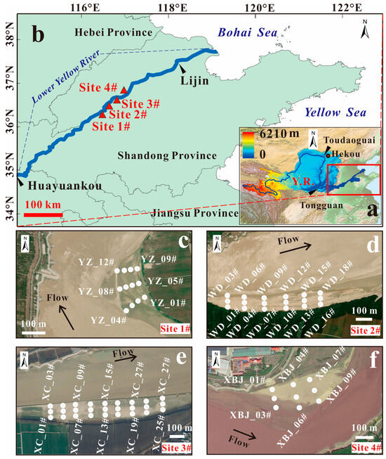
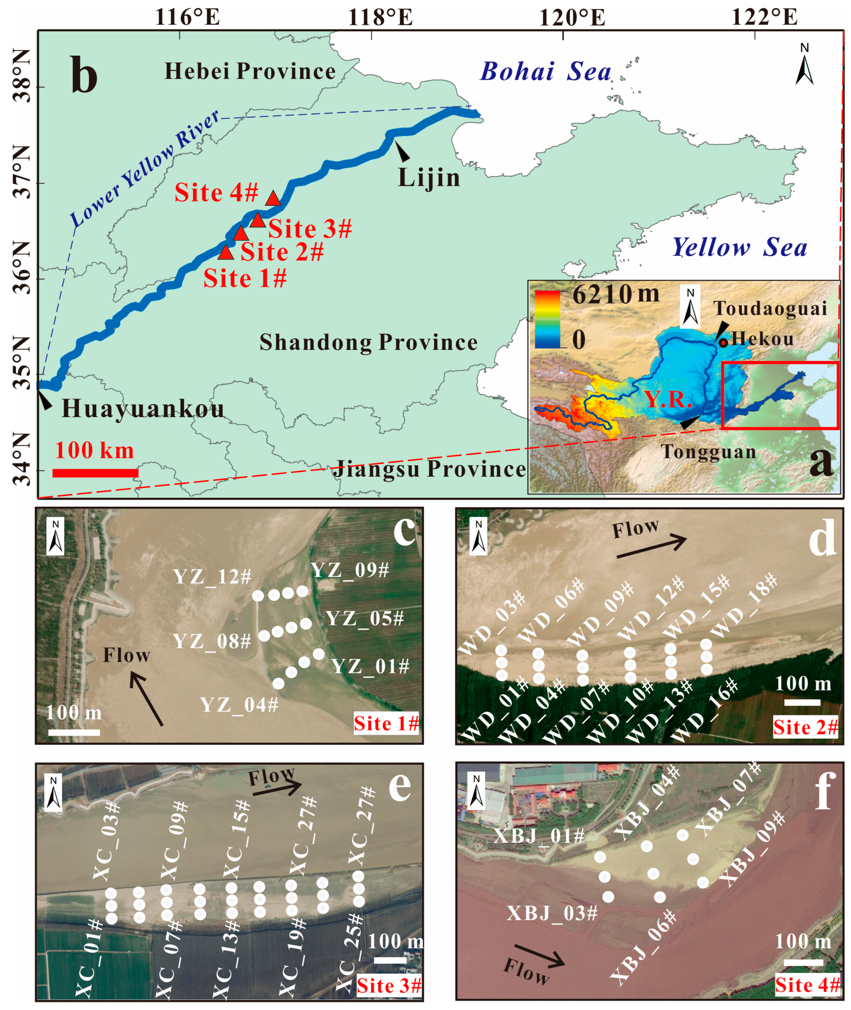
The Yellow River originates from the Qinghai–Tibet Plateau and eventually empties into the Bohai Sea, with a total length of 5400 km [19]. As the sixth-longest river in the world, it was once renowned for its exceptionally high sediment load [37]. Historically, it transfers ~1.08 × 10⁹ t/a of sediment to the Bohai sea, while the runoff volume is 2.1 × 10¹⁰ m3 [37]. As a result, the Yellow River channel has undergone more than 11 diversions since 1855 [19]. However, this high sediment load has dropped by ~90% over the past 60 years [38]. The annual average sediment load at the Tongguan decreased from 1.6 billion t/yr (average value of 1919–1960) to only 0.26 billion tons in 2000 and 0.055 billion tons in 2015 [28,39]. The YR can be divided into the upper, middle, and lower reaches. The upper YR extends from its source to Hekou Town, with a length of ~3472 km. The catchment area of this segment contributes 58% of the total river discharge into the sea. The middle reaches, spanning ~1206 km, receive sediment mainly from the Loess Plateau. This segment supplies up to 90% of the total sediment load delivered to the sea [40,41]. The lower reaches, covering ~790 km, serve as the primary zone for sediment deposition (Figure 1a) [42]. In particular, this reach has formed the famous “suspended river” (where the riverbed elevation exceeds the surrounding plain) in Henan Province and shaped a delta of ~5450 km2 in eastern China (Figure 1) [43].
Figure 1.
Schematic of the study area. (a) Map showing the location of the Yellow River (Y.R. is abbreviation of Yellow River). (b) Map showing the lowermost reach of the YR, with marked positions of sampling sites (solid red triangles) 1#, 2#, 3#, and 4#. The solid black triangles indicate the hydrological station locations. (c–f) Detailed maps show SWD sample locations for sites 1#, 2#, 3#, and 4# with solid white dots, respectively. Black arrows indicate the direction of water flow. Specifically, in map (c) (site 1#), samples are labeled YZ_01# to YZ_12#. In map (d) (site 2#), samples are labeled WD_01# to WD_18#. In map (e) (site 3#), samples are labeled XC_01# to XC_27#. In map (f) (site 4#), samples are labeled XBJ_01# to XBJ_09#.
The lowermost reach of the YR is located in a temperate monsoon climate zone, with an annual temperature of 13~15 °C. Stretching from Huayuankou to Lijin hydrological station, this river section covers a total length of 625 km. Its longitudinal channel slope is steep in the upper reaches and gentle in the lower reaches, with an average of 1.11‱. (Figure 1) [38]. Precipitation in this region exhibits distinct seasonality, for example, being low in spring and high in summer. Statistical data indicate that summer precipitation accounts for more than 70% of the annual total [41]. The study reach has a length of 85 km, and belongs to a typical alluvial segment in the lower YR (Figure 1b). Artificial concrete embankments have been constructed along both banks of this reach. Along the riverbank, several landforms have developed, including edge bars, central bars, and erosion zones. Additionally, land use patterns in the vicinity of the YR banks have also changed, driven by urbanization and engineering construction activities in recent years.
The study was carried out following a 24-day man-made flood by the Xiaolangdi Dam between 19 June and 13 July 2021. During this period, the discharge regulated by the dam was controlled within the range of 2600–4500 m3/s, with the 4500 m3/s discharge sustained for five consecutive days (http://www.yrcc.gov.cn/, accessed on 7 December 2025). The highest sediment concentration at the reservoir outlet reached 377 kg/m3 (recorded at 23:12 on 4 July) (http://www.yrcc.gov.cn/, accessed on 7 December 2025). Through in-depth field investigations, man-made flood SWDs in the floodplain of the lowermost reach of the YR were selected as the primary research objects.
3. Methods
3.1. Sediments Samples
A field campaign was conducted along the lowermost reach of the YR in September 2021, during which four river floodplains with fresh flood sediments were identified. These floodplains featured relatively flat or gently sloping surfaces, and their flood deposits were minimally disturbed by human activities. The highest point of these floodplains was only 3 m above the water level in the river. The floodplains were designated as the Yanzhuang (YZ), Wudu (WD), Xicang (XC), and Xibeijie (XBJ) sites (Figure 1c–f).
3.2. Field Sampling Methodology
Sediment samples were systematically collected along cross-sections oriented perpendicular to the flow direction, following a bank-to-thalweg (from bank to main channel) sampling method across the study area. Notably, for each cross-section, sampling started at the pinch-out of flood sediments on the riverbank and ended where the flood sediments are adjacent to the river flow. Sediment thickness was considered during sampling, and the layer from the surface to the distinct stratification was regarded as the latest flood SWD layer and sampled. (1) For thick flood deposit layers (>5 cm), the homogeneous mixing method was adopted, i.e., after collecting thick sediment layers, they were homogenized, and approximately 1 kg of bulk rock samples were then collected. For thinner sediment layers (≤5 cm), ~1 kg of bulk rock samples were collected, as a precaution to avoid contamination from the underlying strata. In total, 12 samples (three groups), 18 samples (six groups), 27 samples (nine groups), and 9 samples (three groups) were collected at the Yanzhuang, Wudu, Xicang, and Xibeijie sites, respectively (Figure 1).
3.3. Grain Size Analysis and Parameter Calculation
Collected flood deposit samples were oven-dried at a constant temperature of 40 °C. Approximately 0.2 g of each dried sediment sample was weighed from the collected sample using an electronic balance (JD300-3, China) (accuracy of 0.001 g) and transferred to a clean, numbered beaker. During this step, plant roots and gravel were manually removed to eliminate coarse debris interference. A total of 10 mL HCl (10%) and 10 mL H2O2 (10%) were used to remove carbonates and humic acids. After that, samples were rinsed with pure water 3–5 times until the pH of the sediment suspension reached neutrality. Subsequently, 5 mL of a 5% sodium hexametaphosphate solution (a dispersant) was added to each beaker, and the mixture was sonicated using an ultrasonic disperser (Sonic, China) for at least 10 min to ensure complete particle dispersion. Finally, the grain size distribution of the samples was measured using a Mastersizer 3000 laser particle analyzer (Malvern, UK), which has a measurement range of 0.01 to 3500 μm. Crucially, the laser particle analyzer was calibrated using reference samples prior to measurements to ensure data accuracy. Each sample was measured three times, and the average value was taken as the final test result. All laboratory analyses were conducted in the Particle Size Laboratory of Shandong Normal University, China.
Grain size parameters were calculated using the following formulas [44]:
where MZ, δ1, Sk1, and KG are the mean grain size, sorting coefficient, skewness, and kurtosis, respectively.
4. Results
4.1. Characteristics of Grain Size in Flood SWDs
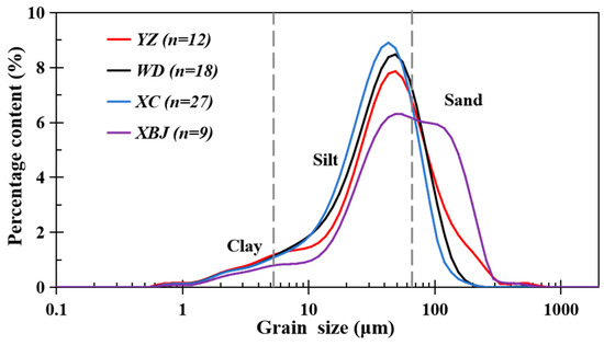
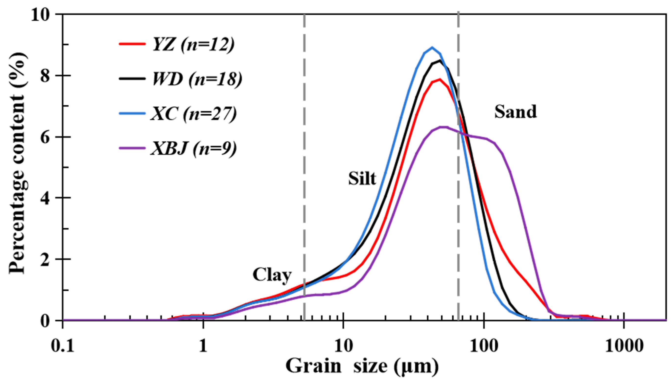
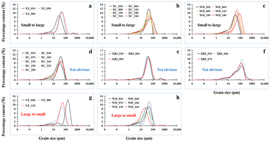
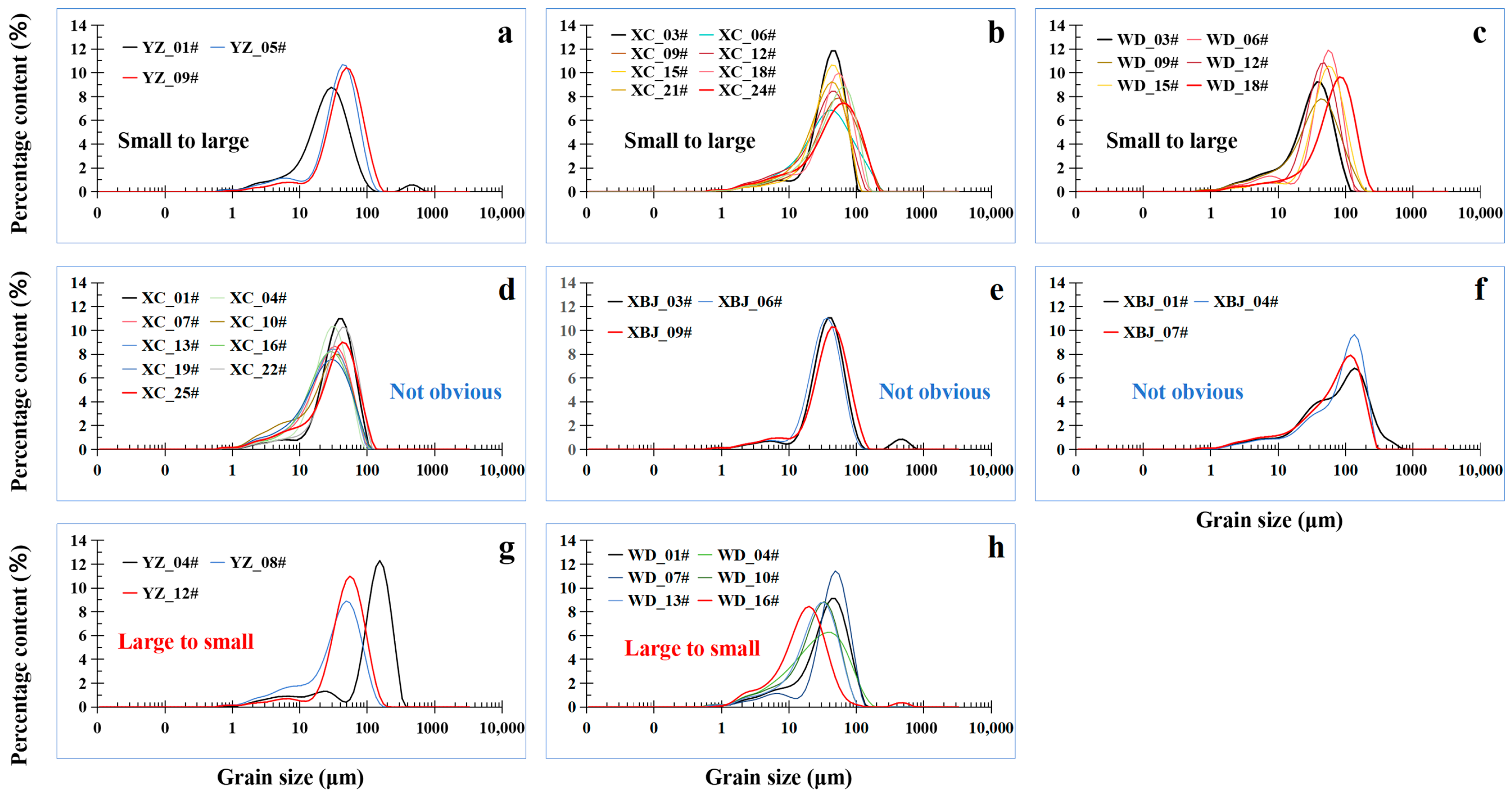
The flood SWDs induced by the man-made flood at the Xiaolandi Dam showed the median grain size (D50) ranging from 17 to 131 μm, with an average of 44.14 μm. The sediments were predominantly silty (Figure 2). Overall, the average proportion of particles < 2 μm (clay) was 1.48%, indicating a low content, whereas the average proportion of particles in the 2–16 μm range (fine silt) was 16.37%. Meanwhile, the average proportion of particles in the 16–63 μm range (coarse silt) was 56.95%, representing the highest content among all grain size fractions, and the average proportion of particles > 63 μm (sand) was 25.19%. Thus, silt remained the dominant grain size fraction. The kurtosis values ranged from 0.03 to 6.05, with an average of 1.02, indicating that the sediments were positively skewed (Table 1). In particular, the median grain size (D50) of sediments from the YZ floodplain ranged from 23.1 to 131 μm, with an average of 49.68 μm, corresponding to coarse silt. SWDs from the XBJ floodplain ranged from 33.1 to 101 μm, with an average of 67.08 μm, corresponding to sand. SWDs from the XC floodplain ranged from 23.9 to 49.7 μm, with an average of 35.67 μm, corresponding to coarse silt. SWDs from the WD floodplain ranged from 20.2 to 68.1 μm, with an average of 40.56 μm, also corresponding to coarse silt.
Figure 2.
Grain size distribution of the flood deposits in the lower Yellow River. The flood was man-made at the Xiaolangdi Dam during June and July 2021.
Table 1.
Sediment characteristics of flood deposits in the lowermost reach of the Yellow River induced by the man-made flood at the Xiaolangdi Dam during June–July 2021.
4.2. Grain Size Characteristics from Bank to Main Channel
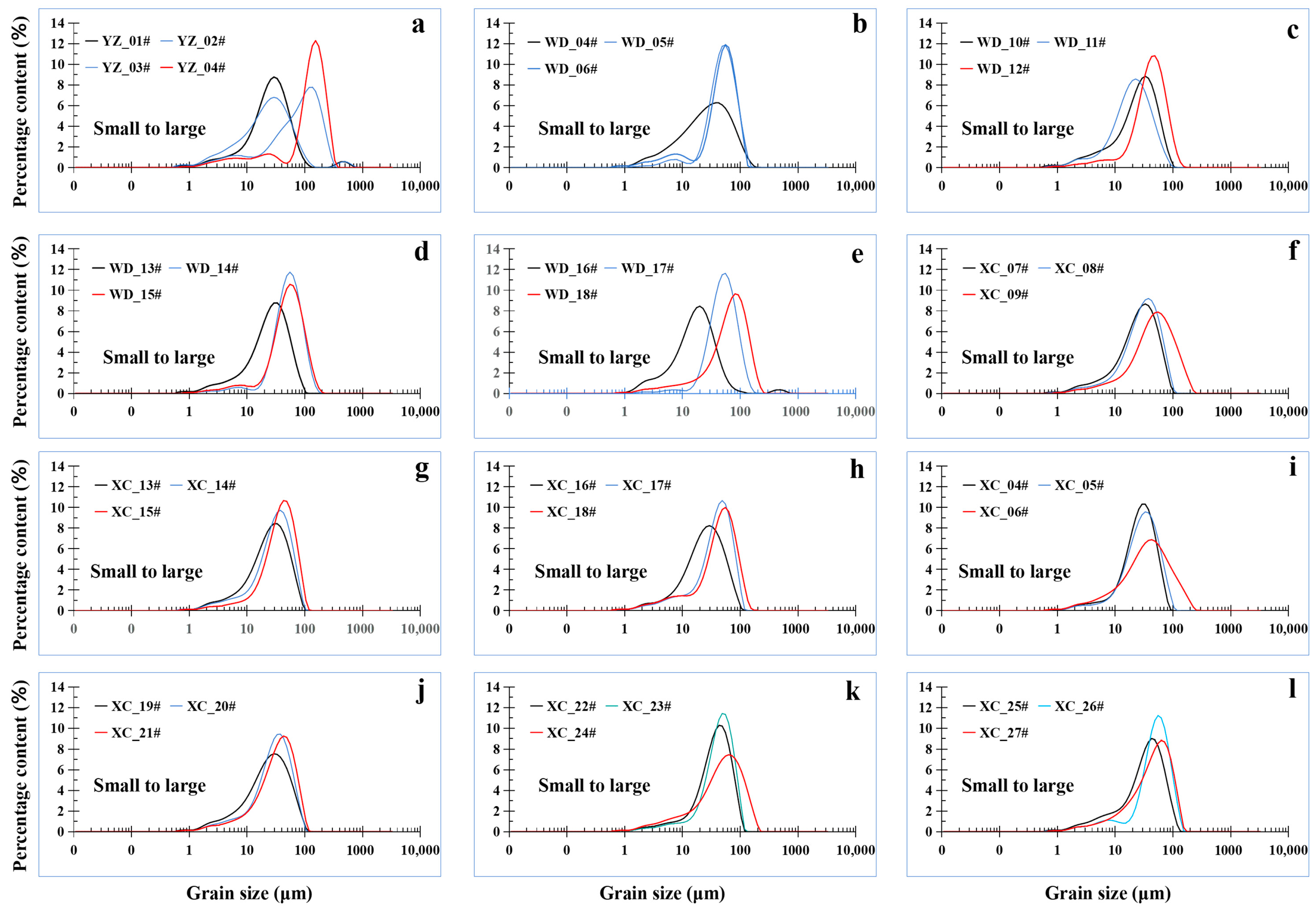
In the four sites (XC, WD, XBJ, and YZ), longitudinal profiles were collected with sampling conducted perpendicularly from the riverbank toward the main channel. The results showed that 12 cross-sectional profiles (accounting for 57.2% of the total 21 profiles) exhibited a trend of increasing grain size (Figure 3). Specifically, one out of the three profiles in YZ (Figure 3a), four out of the six profiles in WD (Figure 3b–e), and seven out of the nine profiles in XC (Figure 3f–i) show the aforementioned pattern.
Figure 3.
The average grain size decreases from the bank to main channel in the lowermost Yellow River. (a–f) show grain size changes from 12 cross-sectional profiles. Specifically, YZ (a), WD (b–e), and XC (f–l) are the abbreviations of Yanzhuang, Wudu, and Xicang, respectively. Each map shows grain size decreases from the riverbank toward the main channel.
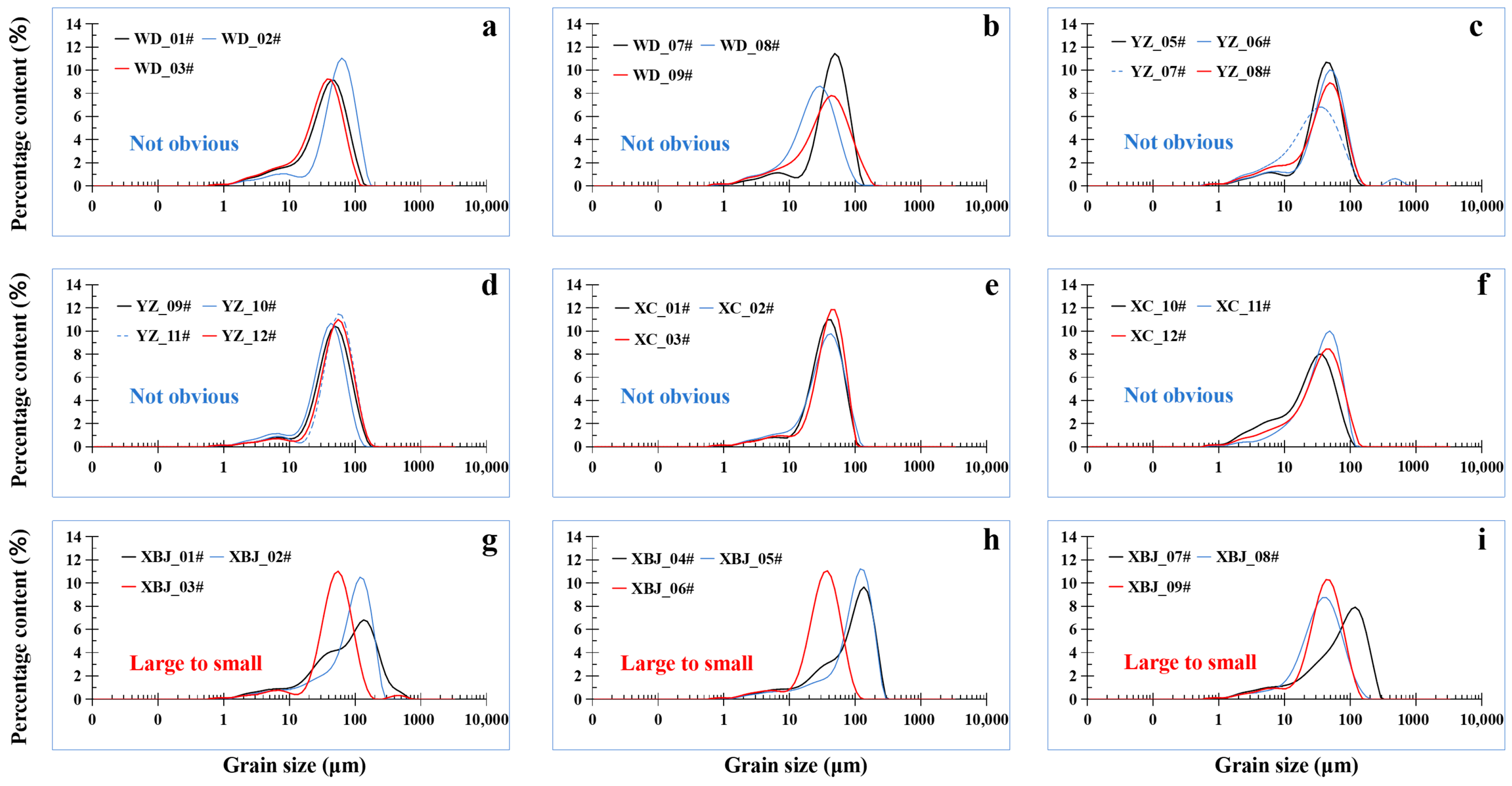
Six cross-sectional profiles (28.6%) showed no obvious grain size variation (Figure 4). Specifically, two out of the six profiles in WD (Figure 4a,b), two out of the three profiles in YZ (Figure 4c,d), and one out of the nine profiles in XC (Figure 4e,f) show the aforementioned pattern. Only three profiles (14.2%) displayed a trend of decreasing grain size (Figure 4g–i). All the three cross-sectional profiles are derived from the XBJ.
Figure 4.
Profiles where the average grain size change is not obvious (a–f) and increases (e–i) from the bank to main channel in the lowermost of the Yellow River. (a–f) show grain sizes with no obvious changes from six cross-sectional profiles, and (e–i) show grain size increases from the bank to main channel. Specifically, YZ (a), WD (b–e), and XC (f–i) are the abbreviations of Yanzhuang, Wudu, and Xicang, respectively.
4.3. Grain Size Characteristics from Upstream to Downstream
For each of the four sampling sites (XC, WD, XBJ, and YZ), two transects (one near-bank and one river-adjacent) were selected to analyze the longitudinal variation in grain size. Notably, the results indicated no obvious regularity in grain size changes along this direction. Among the transects, three profiles (from YZ, XC, and WD) exhibited an increasing grain size trend, three profiles (one from XC and two from XBJ) showed no distinct variation pattern, and two profiles (from YZ and WD) displayed a decreasing grain size trend (Figure 5).
Figure 5.
The average grain size changes from upstream to downstream in the lowermost reach of the Yellow River. (a–c) show grain size decreases from three profiles from upstream to downstream. (d–f) show grain sizes with no obvious changes from three profiles, and (g,h) show grain size increases from two profiles from upstream to downstream. Specifically, YZ (a), WD (c,h), XC (b,d), and XBJ (e,f) are the abbreviations of Yanzhuang, Wudu, Xicang, and Xibeijie, respectively.
5. Discussion
During the 2021 flood season, the YR Basin experienced frequent rainfall events with high precipitation amounts and significant overlap in rain-affected areas. Multiple flood events occurred in both the main stream and tributaries. The man-made flood SWD samples collected in the study area primarily record the man-made flood event of the WSRP in 2021. Consequently, the sediment deposition period of the first flood episode was relatively long (13 days), leading to the accumulation of thick layers of man-made flood sediments on the low-lying floodplains (Figure 6). The sediment on floodplains from this man-made flood had an average grain size of 44.14 μm, which was predominantly silty (Figure 2). Compared with modern flood sediments from other rivers in China [45,46], these sediments exhibited finer grain sizes, classifying them as fine-grained deposits. Tian et al. [47] found that the average grain size became coarser with increasing distance from the estuary in the middle and lower YR, which reflects depositional sorting in the river channel. The average grain size of the river bed in Kenli is only 10 μm [47], which is approximately 250 km downstream of the study reach. Nevertheless, compared with the grain size of modern flood sediments in the Yellow River Delta (8–31 μm) [48] and that of modern flood sediments in the Jinghe River—a primary tributary of the Yellow River (18.4–25.6 μm) [49]—the grain size of man-made flood sediments in the study area is relatively coarser (44.14 μm).
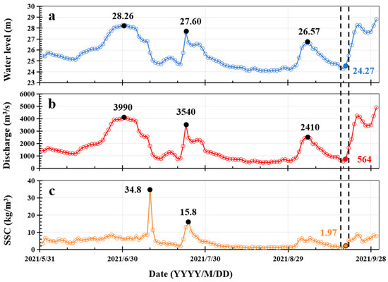
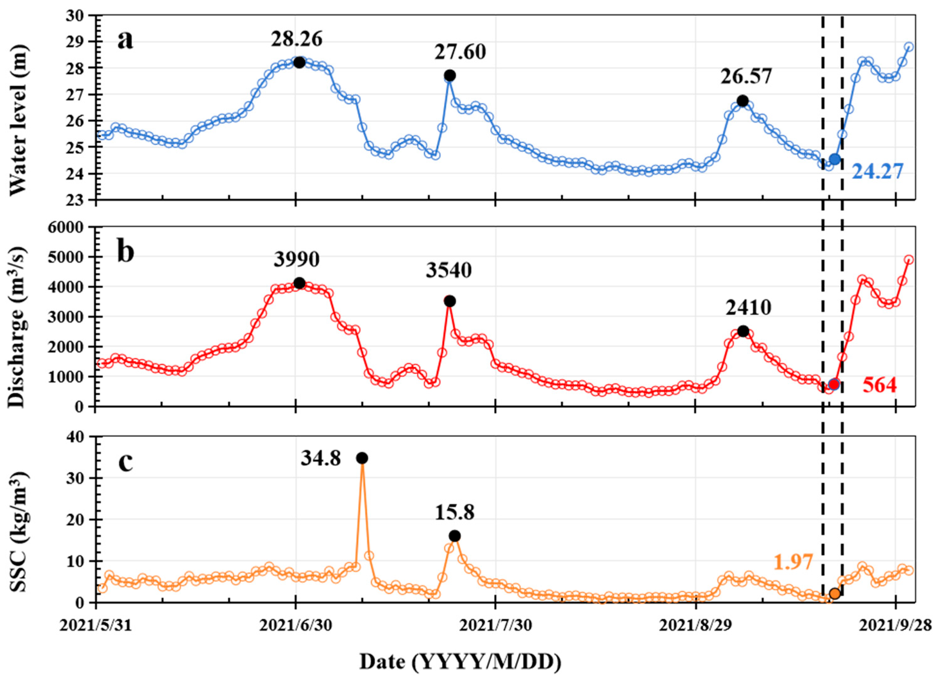
Figure 6.
Water level, discharge, and suspended sediment content observed between 31 May 2021 and 1 October 2021 in the lowermost reaches of the Yellow River. (a–c) show water level, discharge, and SSC, respectively.
Paleoflood SWDs are generally considered to form under low hydrodynamic conditions in high floodplains, terraces, and similar settings [32]. Due to the sudden widening of the river surface, the flow velocity rapidly decreases on floodplains or the backwater areas of tributaries [11,12]. Therefore, the paleoflood SWDs discovered at any given location can be regarded as a key carrier for reconstructing the hydrological characteristics of paleofloods. This understanding differs from the main observational results of this study. Here, across the four cross-sections, 57% of the man-made flood SWDs showed a gradual increase in grain size from the riverbank toward the river channel, with no observable regularity in grain size variation along the longitudinal (upstream-to-downstream) direction (Figure 3, Figure 4 and Figure 5). This finding indicates that during the deposition process of floodplain floods, differences can exist in the direction perpendicular to the riverbank. Similar findings have also been reported in the Hanjiang River. For instance, Zheng et al. [50] also noted that differences in the grain size of flood SWDs at the same location may be caused by variations in sediment sources or hydrodynamic conditions across multiple flood episodes.
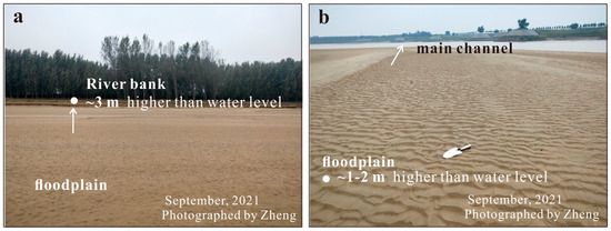
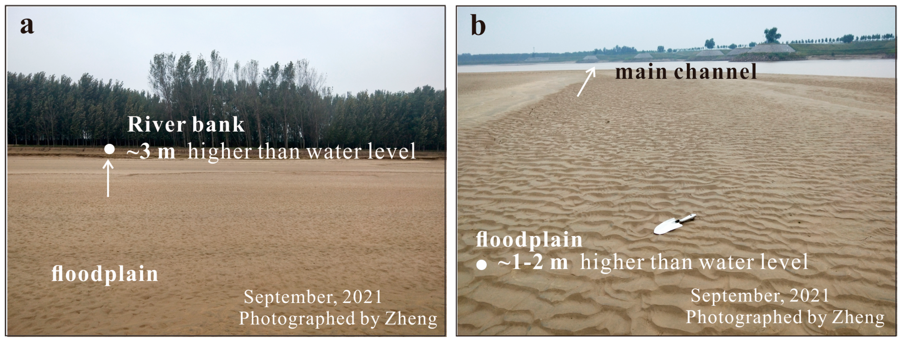
The Xiaolangdi Reservoir is located on the mainstream of the Yellow River in Luoyang City, 130 km downstream from the Huayuankou Hydrological Station [51]. With a total storage capacity of 12.65 billion m3, the reservoir has a drainage area of 694,000 km2, accounting for 92.3% of the total catchment area of the Yellow River upstream of the location [51]. It regulates over 90% of the incoming water and 100% of the incoming sediment of the Yellow River Basin, serving as a key control project in the river’s water and sediment regulation system [38]. Thus, the catchment area and sediment sources of the man-made flood sediments in this study can be considered similar. The floodplains in the study area have relatively low elevations, generally only 1–3 m above the water surface at the time of sampling (Figure 7). During flood periods, the water level of the river rises, causing the floodwater in the channel to overflow onto the floodplain and cover its surface [15]. Meanwhile, the sudden widening of the flow path in the flood zone leads to reduced hydrodynamic force and weakened scouring capacity in the floodplain area, where deposition thus becomes the dominant process [32,52]. Therefore, the impact of topographic changes on the flood deposition process can be neglected. Therefore, for the same flood event or successive floods occurring within a short period, the main factors affecting sediment characteristics are the flood process, flood frequency, and differences in hydrodynamic conditions in the direction perpendicular to the river channel.
Figure 7.
Photo of the study floodplains during September 2021 in the lowermost reaches of the Yellow River. (a) shows floodplain and river bank. (b) shows floodplain and main channel.
During sampling, the water level was 24 m in the lowermost reaches of the Yellow River (Figure 6). The highest point of these floodplains was only 3 m above this level—meaning a water level of 27 m would completely submerge the sampled area (Figure 7). Additionally, the elevation of the study area’s floodplains gradually decreases from the bank to the river channel (Figure 7), leading to differences in the duration and intensity of flood impacts at different locations across the floodplain under varying flood peak discharges and event durations. For the first flood episode, the flood peak was relatively high (28.26 m), and the water level remained above 27 m for approximately 13 days (24 June–6 July). In contrast, the second flood episode had a peak of only 27.6 m, with the water level exceeding 27 m for just one day (Figure 6). These factors may all have contributed to the variation in sediment samples from the riverbank to the channel center. Consequently, these floodplains were disturbed by at least two flood episodes in 2021—with some samples (e.g., those near the channel center) potentially affected by three episodes. Therefore, it cannot be ruled out that the variation in man-made flood SWDs stems from differences in sediment sources across flood episodes or from re-sorting by hydrodynamic conditions of different flood events.
In paleoflood studies, ascertaining the number of flood episodes contributing to a specific slack-water deposit (SWD) remains challenging due to the considerable temporal span since the target paleofloods [52,53,54]. Furthermore, many studies rely on single or limited samples to analyze the sedimentary characteristics of paleoflood SWDs, which underscores the need to fully consider both the flood event process itself and the potential for multiple floods to alter SWD characteristics.
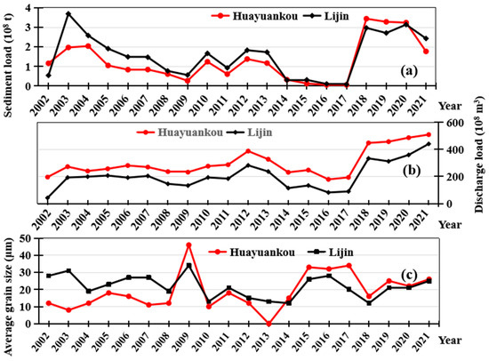
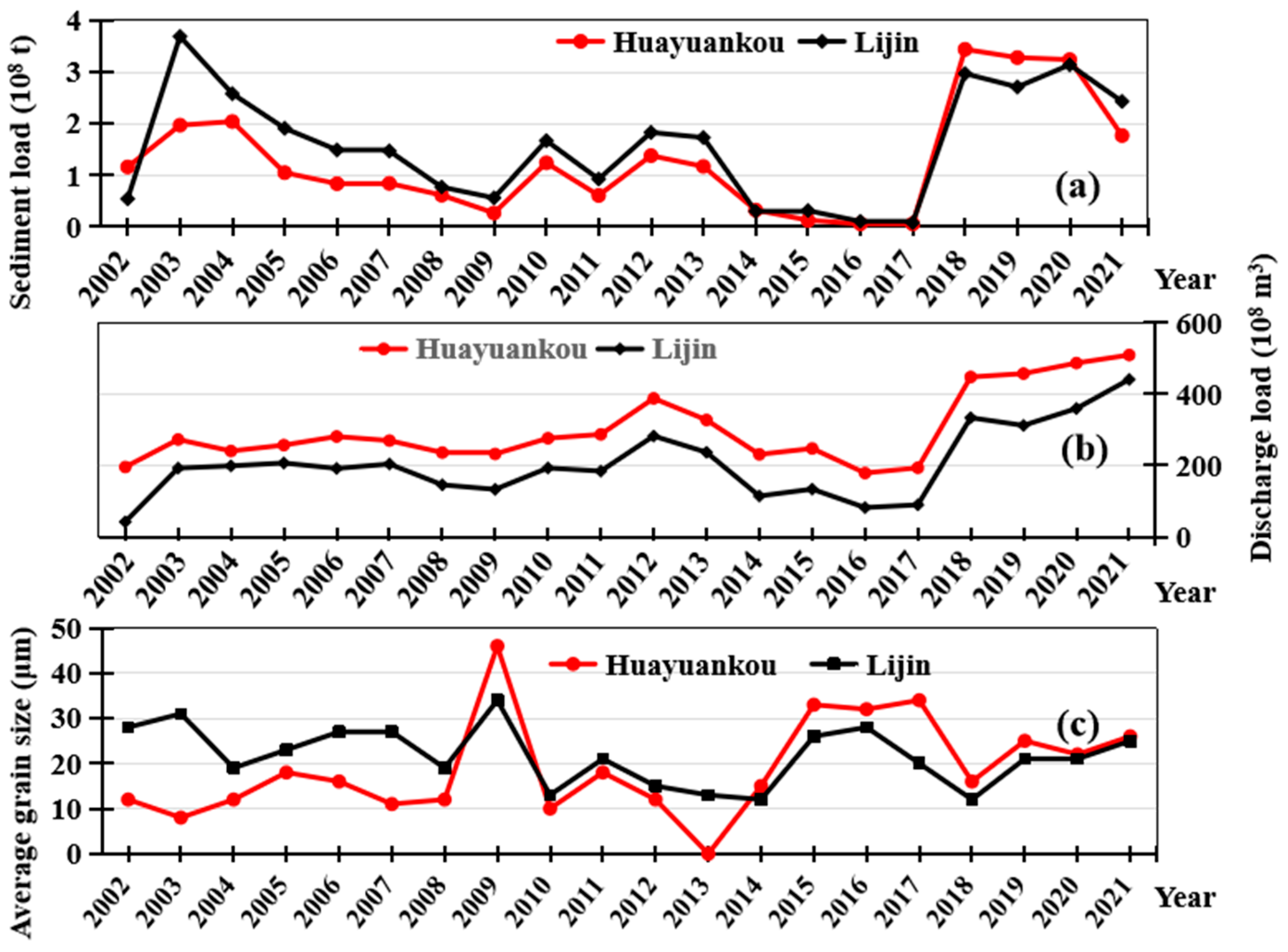
Over the past two decades, except for an interruption in 2020, the WSRP of the Yellow River has effectively scoured sediment in the lower river channel, causing erosion in the middle and lower reaches of the YR [35,55]. However, observational data from the Huayuankou and Lijin hydrological stations indicate that there is no positive correlation between sediment discharge and the average grain size of suspended sediment (Figure 8). In specific years, there may be a trend of increasing sediment discharge accompanied by a decreasing average grain size of suspended sediment, such as in 2009 and 2015–2019. In 2021, the annual runoff at the Huayuankou and Lijin hydrological stations was 50.97 and 44.11 billion cubic meters, respectively, the highest since 2002 (Figure 8b). Nevertheless, the annual sediment discharge in this year decreased by 147 million tons and 71 million tons compared with the previous year, while the average grain size increased by 4 μm and 4 μm, respectively. Thus, this indicates that the man-made flood by dam may be not effective in delivering coarse sediment downstream, and that extreme floods will not allow finer particles to settle. Such changes in the sediment transport process may have a long effect on the deltaic development and stability of the Yellow River mouth.
Figure 8.
Sediment load (a), discharge load (b), and average grain size (c) at the Huanyuankou and Lijin stations from 2002 to 2021 in the Yellow River.
However, modern flood SWDs were collected only after the 2021 WSRP, lacking comparative data from different years and flood magnitudes. Thus, this study’s results may not fully represent the lower Yellow River’s universal sedimentary responses to man-made floods. Meanwhile, although water level and discharge data inferred the affecting man-made flood events, there is no evidence confirming whether the studied SWDs were influenced by other dynamic forces. This may introduce uncertainties to grain size variation interpretation.
6. Conclusions
This study conducted an in-depth field investigation on man-made flood sediments from the 2021 Water and Sediment Regulation Project (WSRP), China, in the lowermost reach of the Yellow River. The study found that the man-made flood by dam was ineffective in delivering coarse sediment downstream. The flood sediments were predominantly silt with a median grain size of 44.14 μm, ranging from 17 to 131 μm. Overall, the average proportion of particles < 2 μm (clay) was 1.48%, indicating a low content, whereas the average proportion of particles in the 2–16 μm range (fine silt) was 16.37%. Meanwhile, the average proportion of particles in the 16–63 μm range (coarse silt) was 56.95%, representing the highest content among all grain size fractions, and the average proportion of particles > 63 μm (sand) was 25.19%. The kurtosis values ranged from 0.03 to 6.05, with an average of 1.02, indicating that the sediments were positively skewed. Along the direction from the riverbank to the channel center, 57% of the man-made flood SWDs exhibited a trend of grain size coarsening. This finding indicates that during the deposition process of floodplain floods, differences may exist in the direction perpendicular to the riverbank. Along the upstream-to-downstream direction, no obvious regularity was observed. Moreover, the man-made flood by dam may not be effective in delivering coarse sediment downstream, and extreme floods will not allow finer particles to settle. Such changes in the sediment transport process may have a long effect on the deltaic development and stability of the Yellow River mouth.
Author Contributions
Methodology, S.G. and Y.L.; Software, W.C.; Formal analysis, Y.L. and Y.T.; Investigation, S.G., H.W. and S.Z.; Writing—original draft, S.G., Y.X., Y.T., H.W. and S.Z.; Writing—review and editing, Y.X., D.K. and S.Z.; Funding acquisition, Y.X., W.C. and D.K. All authors have read and agreed to the published version of the manuscript.
Funding
This research was funded by the Open Found Project of Shandong Engineering Research Center for Environmental Protection and Remediation on Groundwater, grant number 801KF2024-8, the Natural Science Foundation of China (grant number 42201009), and the Education Department of Jiangsu Province (grant number 22KJB170022).
Data Availability Statement
The original contributions presented in this study are included in the article. Further inquiries can be directed to the corresponding authors.
Conflicts of Interest
The authors declare no conflicts of interest.
References
- Gao, L.; Tao, B.; Miao, Y.; Zhang, L.; Song, X.; Ren, W.; He, L.; Xu, X. A Global Data Set for Economic Losses of Extreme Hydrological Events During 1960–2014. Water Resour. Res. 2019, 55, 5165–5175. [Google Scholar] [CrossRef] [Scilit]
- Huang, C.C.; Pang, J.; Zha, X.; Su, H.; Jia, Y. Extraordinary floods related to the climatic event at 4200 a BP on the Qishuihe River, middle reaches of the Yellow River, China. Quat. Sci. Rev. 2011, 30, 460–468. [Google Scholar] [CrossRef] [Scilit]
- Nemnem, A.M.; Tanim, A.H.; Nahian, A.; Khan, S.; Goharian, E.; Imran, J. How extreme rainfall and failing dams unleashed the Derna flood disaster. Nat. Commun. 2025, 16, 4191. [Google Scholar] [CrossRef] [Scilit] [PubMed]
- Wu, X.; Bi, N.; Syvitski, J.; Saito, Y.; Xu, J.; Nittrouer, J.A.; Bianchi, T.S.; Yang, Z.; Wang, H. Can Reservoir Regulation Along the Yellow River Be a Sustainable Way to Save a Sinking Delta? Earth’s Future 2020, 8, e2020EF001587. [Google Scholar] [CrossRef] [Scilit]
- Vozinaki, A.E.K.; Kourgialas, N.N.; Karatzas, G.P. Estimating Flood Inundation and the Consequent Economic Losses in the Koiliaris River Basin in Crete, Greece. Glob. Nest J. 2012, 14, 284–293. [Google Scholar] [CrossRef] [Scilit]
- Song, W.; Guan, M.; Yu, D. SwinFlood: A hybrid CNN-Swin Transformer model for rapid spatiotemporal flood simulation. J. Hydrol. 2025, 660, 133280. [Google Scholar] [CrossRef] [Scilit]
- Anghel, C.G.; Ilinca, C. Predicting Flood Frequency with the LH-Moments Method: A Case Study of Prigor River, Romania. Water 2023, 15, 2077. [Google Scholar] [CrossRef] [Scilit]
- Li, H.; Hou, Y.; Yang, Y.; Shang, X.; Yu, Z.; Shen, J.; Tang, Q.; Xiao, Z.; Zhang, H.; Huang, Y. The characteristics of modern flood deposits in the lower reaches of a small watershed and the significance of paleo-flood identification. Quat. Int. 2024, 708, 17–25. [Google Scholar] [CrossRef] [Scilit]
- Huo, R.; Chen, H.; Li, L.; Xu, Y.C.; Li, J.; Hong, S.; Zhan, C.; Xia, J. Flood variability in the upper Yangtze River over the last millennium—Insights from a comparison of climate-hydrological model simulated and reconstruction. Chin. Sci. Earth Sci. 2023, 66, 547–567. [Google Scholar] [CrossRef] [Scilit]
- Yu, S.; Li, W.; Zhou, L.; Yu, X.; Zhang, Q.; Shen, Z. Human disturbances dominated the unprecedentedly high frequency of Yellow River flood over the last millennium. Sci. Adv. 2023, 9, eadf8576. [Google Scholar] [CrossRef] [Scilit]
- Guo, Y.; Ge, Y.; Mao, P.; Liu, T.; Fu, X.; Wu, S. Geomorphologic evidences and hydrologic reconstruction of Holocene catastrophic flood events in the Yarlung Tsangpo Grand Canyon, Eastern Himalaya. J. Hydrol. 2023, 626, 130146. [Google Scholar] [CrossRef] [Scilit]
- Shang, L.; Zha, X.; Huang, C.C.; Zhou, Y.; Pang, J.; Li, Y.; Wang, Z. Reconstructing the magnitudes of Holocene extraordinary floods in the upper Huai River, China. Quat. Sci. Rev. 2025, 359, 109371. [Google Scholar] [CrossRef] [Scilit]
- Bai, J.J.; Zou, H.X.; Zhu, C. Archaeological discovery and research on the remains of the paleoflood of the Yuxi sit. Sci. Bull. 2008, 53, 18–27. [Google Scholar] [CrossRef] [Scilit]
- Shen, Z.; Aeschliman, M.; Conway, N. Paleodischarge reconstruction using oxbow lake sediments complicated by shifting hydrological connectivity. Quat. Int. 2021, 604, 75–81. [Google Scholar] [CrossRef] [Scilit]
- Mao, P.; Pang, J.; Huang, C.; Zha, X.; Zhou, Y.; Gou, Y.; Zhou, L. A multi-index analysis of the extraordinary paleoflood events recorded by slackwater deposits in the Yunxi Reach of the upper Hanjiang River, China. CATENA 2016, 145, 1–14. [Google Scholar] [CrossRef] [Scilit]
- Sandercock, P.; Wyrwoll, K.H. The historical and palaeoflood record of Katherine river, northern Australia: Evaluating the likelihood of extreme discharge events in the context of the 1998 flood. Hydrol. Process. 2005, 19, 4107–4120. [Google Scholar] [CrossRef] [Scilit]
- Huang, X.; Zhang, Y.; Guo, Y.; Ge, Y.; Mao, P.; Liu, T.; Wang, S. Outburst flood events since the Last Glacial Maximum in the Hutiao Gorge of Jinsha River: Geomorphological evidence from eddy gravel bars. Geomorphology 2024, 465, 109415. [Google Scholar] [CrossRef] [Scilit]
- Sridhar, A.; Bhushan, R.; Balaji, D.; Band, S.; Chamyal, L.S. Geochemical and Sr-Nd isotopic variations in palaeoflood deposits at mainstem-tributary junction, western India: Implications on late Holocene flood events. CATENA 2016, 139, 32–43. [Google Scholar] [CrossRef] [Scilit]
- Ma, L.; Ding, D.; Wang, G.; Huang, Y.; Lv, Y.; Li, G. Analysis of the evolution of the current estuarine geomorphology of the Yellow River under 20 years of water and sediment regulation. J. Hydrol. 2025, 646, 132344. [Google Scholar] [CrossRef] [Scilit]
- Harrison, S.; Macklin, M.G.; Toonen, W.H.J.; Benito, G.; Cohen, K.M. Robust climate attribution of modern floods needs palaeoflood science. Clim. Change 2025, 178, 71. [Google Scholar] [CrossRef] [Scilit]
- Gao, W.; Li, K.; Miao, X.; Zhou, L. Holocene extreme flood distribution patterns in the upper and middle Yellow River: A review based on slackwater deposits. Earth-Sci. Rev. 2025, 26, 105039. [Google Scholar] [CrossRef] [Scilit]
- Chen, Y. Flood dynamics of the lower Yellow River over the last 3000 years: Characteristics and implications for geoarchaeology. Quat. Int. 2019, 521, 147–157. [Google Scholar] [CrossRef] [Scilit]
- Gao, W.; Yuan, H.; Pan, Y.; Jia, W.; Liu, X.; Li, K. Spatiotemporal variation of human settlement distribution between the Shang and Western Zhou dynasties in relation to flooding in the lower Yellow River floodplain, East China. J. Archaeol. Sci. Rep. 2023, 52, 104260. [Google Scholar] [CrossRef] [Scilit]
- Kundzewicz, Z.W.; Huang, J.; Pinskwar, I.; Su, B.; Jiang, T. Climate variability and floods in China—A review. Earth-Sci. Rev. 2020, 211, 103434. [Google Scholar] [CrossRef] [Scilit]
- Wang, H.; Wu, X.; Bi, N.; Li, S.; Yuan, P.; Wang, A.; Syvitski, J.P.M.; Saito, Y.; Yang, Z.; Liu, S.; et al. Impacts of the dam-orientated water-sediment regulation scheme on the lower reaches and delta of the Yellow River (Huanghe): A review. Glob. Planet. Change 2017, 157, 93–113. [Google Scholar] [CrossRef] [Scilit]
- Xu, B.; Yang, D.; Yao, P.; Burnett, W.C.; Ran, X.; Charette, M.; Huang, X.; Liu, S.; Yu, Z. A New Perspective for Assessing Water Transport and Associated Retention Effects in a Large Reservoir. Geophys. Res. Lett. 2018, 45, 9462–9650. [Google Scholar] [CrossRef] [Scilit]
- Xu, M.; Wang, G.; Wang, Z.; Hu, H.; Shingh, D.K.; Tian, S. Temporal and spatial hydrological variations of the Yellow River in the past 60 years. J. Hydrol. 2022, 609, 127750. [Google Scholar] [CrossRef] [Scilit]
- Zhao, H.; Huang, C.C.; Zheng, Z.; Hu, Y.; Zhang, Y.; Guo, Y.; Zhou, Q. New evidence for the catastrophic demise of a prehistoric settlement (the Lajia Ruins) in the Guanting Basin, upper Yellow River, NW China. J. Asian Earth Sci. 2017, 146, 134–141. [Google Scholar] [CrossRef] [Scilit]
- Li, T.; Li, J.; Zhang, D. Yellow River flooding during the past two millennia from historical documents. Prog. Phys. Geogr. 2020, 44, 661–678. [Google Scholar] [CrossRef] [Scilit]
- Dong, G.; Zhang, F.; Liu, F.; Zhang, D.; Zhou, A.; Yang, Y.; Wang, G. Multiple evidences indicate no relationship between prehistoric disasters in Lajia site and outburst flood in upper Yellow River valley, China. Chin. Sci. Earth Sci. 2018, 61, 441–449. [Google Scholar] [CrossRef] [Scilit]
- Huang, C.C.; Pang, J.; Zha, X.; Zhou, Y.; Su, H.; Zhang, Y.; Wang, H.; Gu, H. Holocene palaeoflood events recorded by slackwater deposits along the lower Jinghe River valley, middle Yellow River basin, China. J. Quat. Sci. 2012, 27, 485–493. [Google Scholar] [CrossRef] [Scilit]
- Zheng, S.; He, J.; Wu, B. Water and Sediment Regulation by Cascade Dams at the Yellow River, China. J. Hydrol. Eng. 2023, 28, 05023020. [Google Scholar] [CrossRef] [Scilit]
- Wang, H.; Bi, N.; Saito, Y.; Wu, X.; Wang, A. Deltaic responses to dam regulation on river system: Example of the Yellow River, China. In Proceedings of the Agu Fall Meeting 2014, San Francisco, CA, USA, 15–19 December 2014. [Google Scholar]
- Kong, D.; Miao, C.; Wu, J.; Duan, Q.; Sun, Q.; Ye, A.; Di, Z.; Gong, W. The hydro-environmental response on the lower Yellow River to the water–sediment regulation scheme. Ecol. Eng. 2015, 79, 69–79. [Google Scholar] [CrossRef] [Scilit]
- Xia, J.; Lin, B.; Falconer, R.A.; Wang, Y. Modelling of man-made flood routing in the lower Yellow River, China. Water Manag. 2012, 165, 377–391. [Google Scholar] [CrossRef] [Scilit]
- Duan, M.; Qiu, Z.; Li, R.; Li, K.; Yu, S.; Liu, D. Monitoring Suspended Sediment Transport in the Lower Yellow River Using Landsat Observations. Remote Sens. 2024, 16, 229. [Google Scholar] [CrossRef] [Scilit]
- Yu, Y.; Wang, H.; Shi, X.; Ran, X.; Cui, T.; Qiao, S.; Liu, Y. New discharge regime of the Huanghe (Yellow River): Causes and implications. Cont. Shelf Res. 2013, 69, 62–72. [Google Scholar] [CrossRef] [Scilit]
- Fan, J.; Zhao, G.; Mu, X.; Lu, A.; Tian, P.; Gao, P.; Sun, W. Effects of cascading reservoirs on streamflow and sediment load with machine learning reconstructed time series in the upper Yellow River basin. CATENA 2023, 225, 107008. [Google Scholar] [CrossRef] [Scilit]
- Wang, H.; Yang, Z.; Saito, Y.; Liu, J.P.; Sun, X.; Wang, Y. Stepwise decreases of the Huanghe (Yellow River) sediment load (1950–2005): Impacts of climate change and human activities. Glob. Planet. Change 2007, 57, 331–354. [Google Scholar] [CrossRef] [Scilit]
- Zhang, Y.; Chai, Y.; Hu, C.; Xu, Y.; Zhou, Y.; Chen, H.; Li, Z.; Gang, S.; Zheng, S. Subaqueous Topographic Deformation in Abandoned Delta Lobes—A Case Study in the Yellow River Delta, China. Water 2023, 15, 2050. [Google Scholar] [CrossRef] [Scilit]
- Bi, N.; Wang, H.; Wu, X.; Saito, Y.; Xu, C.; Yang, Z. Phase change in evolution of the modern Huanghe (Yellow River) Delta: Process, pattern, and mechanisms. Mar. Geol. 2021, 437, 106516. [Google Scholar] [CrossRef] [Scilit]
- Li, D.; Gao, W.; Shao, D.; Amenuvor, M.; Tong, Y.; Cui, B. A Tale of Two Deltas: Dam-Induced Hydro-Morphological Evolution of the Volta River Delta (Ghana) and Yellow River Delta (China). Water 2021, 13, 3198. [Google Scholar] [CrossRef] [Scilit]
- Folk, R.L.; Ward, W.C. Brazos River Bar: A Study in the Significance of Grain Size Parameters. J. Sediment. Res. 1957, 27, 3–26. [Google Scholar] [CrossRef] [Scilit]
- Zhang, L.; Zhang, Z.; Chen, Y.; Fu, Y. Sediment characteristics, floods, and heavy metal pollution recorded in an overbank core from the lower reaches of the Yangtze River. Environ. Earth Sci. 2015, 74, 7451–7465. [Google Scholar] [CrossRef] [Scilit]
- Zhang, Y.; Huang, C.C.; Pang, J.; Zha, X.; Zhou, X.; Yin, S.; Wang, J. Comparative study of the modern flood slackwater deposits in the upper reaches of Hanjiang and Weihe River Valleys, China. Quat. Int. 2012, 282, 184–191. [Google Scholar] [CrossRef] [Scilit]
- Tian, S.; Li, Z.; Wang, Z.; Jiang, E.; Wang, W.; Sun, M. Mineral composition and particle size distribution of river sediment and loess in the middle and lower Yellow River. Int. J. Sediment Res. 2021, 36, 392–400. [Google Scholar] [CrossRef] [Scilit]
- Meng, L.; Wang, L.; Zhao, J.; Zhan, C.; Liu, X.; Cui, B.; Zeng, L.; Wang, Q. End-member characteristics of modern Yellow River Delta sediments and their environmental significance. Front. Mar. Sci. 2024, 10, 1141187. [Google Scholar] [CrossRef] [Scilit]
- Xiangfeng, Z.; Chunchang, H.; Xiaochun, C.; Jiangli, P.; Xiaogang, L.; Yao, P. Sedientological characteristics of mud cracks of the modern flood deposit in Jinghe River basin. J. Arid Land Resour. Environ. 2009, 23, 86–90. [Google Scholar] [CrossRef]
- Zheng, S.; Jiangli, P.; Chunchang, H.; Xiaochun, Z.; Xin, L. Spatial variation of palaeoflood deposits at Yanjiapeng site in the upper reach of the Han River. Prog. Geogr. Sci. 2014, 33, 799–806. [Google Scholar] [CrossRef]
- Xia, X.; Dong, J.; Wang, M.; Xie, H.; Xia, N.; Li, H.; Zhang, X.; Mou, X.; Wen, J.; Bao, Y. Effect of water-sediment regulation of the Xiaolangdi reservoir on the concentrations, characteristics, and fluxes of suspended sediment and organic carbon in the Yellow River. Sci. Total Environ. 2016, 571, 487–497. [Google Scholar] [CrossRef] [Scilit]
- Zhu, C.; Ma, C.; Xu, W.; Bai, J.; Zheng, C.; Zhu, G.; Wang, H.; Chen, Y.; Lu, X. Characteristics of paleoflood deposits archived in unit T0403 of Yuxi site in the Three Gorges reservoir areas, China. Sci. Bull. 2008, 53, 1–17. [Google Scholar] [CrossRef] [Scilit]
- Yang, J.; Shen, J.; Nie, Z.; Wang, Z.; Liu, Z.; Jiang, G. The Discovery of Quaternary Paleoflood Deposits in the South Margin of the Badain Jaran Desert, China. Acta Geol. Sin. 2021, 95, 1755–6724. [Google Scholar] [CrossRef] [Scilit]
- Baker, V.R. Paleoflood hydrology and extraordinary flood events. J. Hydrol. 1987, 96, 79–99. [Google Scholar] [CrossRef] [Scilit]
- Peng, J.; Chen, S.; Dong, P. Temporal variation of sediment load in the Yellow River basin, China, and its impacts on the lower reaches and the river delta. CATENA 2010, 83, 135–147. [Google Scholar] [CrossRef] [Scilit]
- Lu, M.; Zhao, Q.; Ding, S.; Wang, S.; Hong, Z.; Jing, Y.; Wang, A. Hydro-geomorphological characteristics in response to the water-sediment regulation scheme of the Xiaolangdi Dam in the lower Yellow River. J. Clean. Prod. 2022, 335, 130324. [Google Scholar] [CrossRef] [Scilit]

Disclaimer/Publisher’s Note: The statements, opinions and data contained in all publications are solely those of the individual author(s) and contributor(s) and not of MDPI and/or the editor(s). MDPI and/or the editor(s) disclaim responsibility for any injury to people or property resulting from any ideas, methods, instructions or products referred to in the content. |
© 2026 by the authors. Licensee MDPI, Basel, Switzerland. This article is an open access article distributed under the terms and conditions of the Creative Commons Attribution (CC BY) license.