


Abstract
The formation and disappearance of paleolakes are sensitive indicators of environmental evolution in arid and semi-arid regions. Their disappearance records comprehensive information on regional hydrological conditions, climatic changes, and tectonic activities, thereby offering unique research value for elucidating the environmental driving mechanisms behind water resource changes in historical human settlements and the concomitant rise and fall of civilizations. This study analyzed the contact interface between extensively distributed lacustrine deposits and the overlying aeolian dune sands around Tongwan City using optically stimulated luminescence (OSL), and combined with relevant documentary evidence to elucidate the relationship between paleolake disappearance and the abandonment of the ancient city. The OSL dating results demonstrated that the disappearance of paleolakes and the initiation of desertification around Tongwan City were mainly concentrated between about 1200 and 900 years before present, closely corresponding to the abandonment of Tongwan City in AD 994. Field investigations additionally revealed that well-developed fluvial erosion surfaces are pervasively present at the top of lacustrine deposits around Tongwan City, while multiple fluvial terraces are exposed along the Wuding River. These features collectively indicate that regional crustal uplift event led to fluvial incision. The results indicated that the abandonment of Tongwan City was not attributable solely to climatic aridification, but instead resulted from the combined influences of favorable hydrothermal conditions during the High-Temperature Period of the Northern Song (HTNS, AD 994–1094) and regional tectonic uplift. Tectonic uplift facilitated deep incision of the Wuding River valley, while increased precipitation during the warm period enhanced surface water infiltration and drainage, resulting in a significant decline in groundwater levels, the disappearance of paleolakes, and ultimately the depletion of water resources upon which the ancient city relied. These findings provide new evidence from an environmental geological perspective and present a key scientific explanation for the paradox that Tongwan City was abandoned during a relatively warm climatic interval. Furthermore, the coupled mechanism of tectonic uplift, fluvial incision, sharp groundwater decline, and societal collapse revealed in this study not only provides a valuable reference for investigating the abandonment of ancient cities in arid and semi-arid regions during historical periods, but also offers important implications for assessing water resource vulnerability of ancient settlements on analogous geomorphic units under global climate change, and may serve as a geological–historical warning and reference for water security management in human habitations under current and future warm-climate conditions.
1. Introduction
The Mu Us Desert, situated in the monsoon marginal zone, is highly sensitive to both climate change and anthropogenic activities. Lake shrinkage and disappearance in this region have long been a major focus in environmental change research across arid and semi-arid zones. Over geological timescales, repeated paleolake desiccation events occurred here, driven by a range of interacting factors, including precipitation–evaporation balance, hydrological reorganization, tectonic activity, and anthropogenic forcing. For example, the formation and evolution of the paleolake on the left bank of the Salawusu River were closely related to East Asian monsoon variability [1]; the demise of the Chengchuan paleolake has been attributed to the combined influence of climate change and human activities [2]; and the interplay between hydrological alteration and tectonic movements has also been recognized as a significant driver [3]. These findings collectively underscore the considerable complexity underlying paleolake disappearance in the Mu Us Desert.
As a transitional zone of monsoon evolution, the Mu Us Desert offers an ideal natural laboratory for examining the interplay between environmental change and human societal development. The upper reaches of the Wuding River and its tributary, the Salawusu River, located along the southern margin of the Mu Us Desert, were historically referred to as the Sheyan River during the Northern Wei Dynasty [4]. Currently, some scholars also consider these two rivers collectively as the Wuding River system. Several historical ancient cities, including Tongwan City, Dashibian Ancient City, and Chengchuan Ancient City, are distributed throughout this river basin. Among these, the ruins of Tongwan City, situated along the Wuding River, have become an important site for examining the coupling relationships among desert dynamics, the rise and decline of ethnic settlements, and environmental changes because of their distinctive historical significance and well-preserved architectural remains [5,6,7]. The causes of the abandonment of Tongwan City have long remained under debate, with two principal explanations focusing on either anthropogenic influences or natural processes. The former proposes that excessive land reclamation, overgrazing, and other human activities led to ecological degradation [8,9,10], which, together with military and political factors [11], eventually resulted in the abandonment of the city. In contrast, the latter attributes the abandonment primarily to climatic deterioration, especially aridity and desertification [5,12,13]. However, existing environmental records indicate that Tongwan City was abandoned in AD 994, which coincides with the onset of the Warm Period of the Northern Song (WPNS). This chronological inconsistency raises challenges for interpretations that rely solely on climatic deterioration.
Field investigations indicated that Tongwan City was constructed directly upon shallow to dark-gray lacustrine deposits, which are widely overlain by yellowish to brownish-yellow mobile dune sands. A clear depositional boundary distinctly separates these two sedimentary units. This interface preserves the abrupt environmental shift from a lacustrine setting to a desert landscape and may retain critical evidence regarding the abandonment of the ancient city. In particular, whether the timing of lacustrine termination and the initiation of desertification was intrinsically associated with the abandonment of Tongwan City remains a key unresolved issue. To address this question, a systematic OSL dating study was conducted on the uppermost lacustrine deposits and the overlying aeolian sands in the surrounding area of Tongwan Ancient City (the surrounding area of Tongwan Ancient City, TWSA) to precisely constrain the timing of paleolake disappearance. By integrating the regional tectonic framework with available paleoclimatic records, it is proposed that the abandonment of Tongwan City resulted from the combined effects of favorable hydrothermal conditions during the HTNS and regional tectonic uplift. These findings not only provide new environmental geological evidence for resolving the long-standing question surrounding the abandonment of Tongwan City but also contribute to a broader understanding of the relationships between river–lake evolution and the rise and decline of civilizations in arid and semi-arid regions.
2. Materials and Methods
2.1. Study Area and Sample Collection
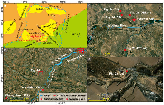
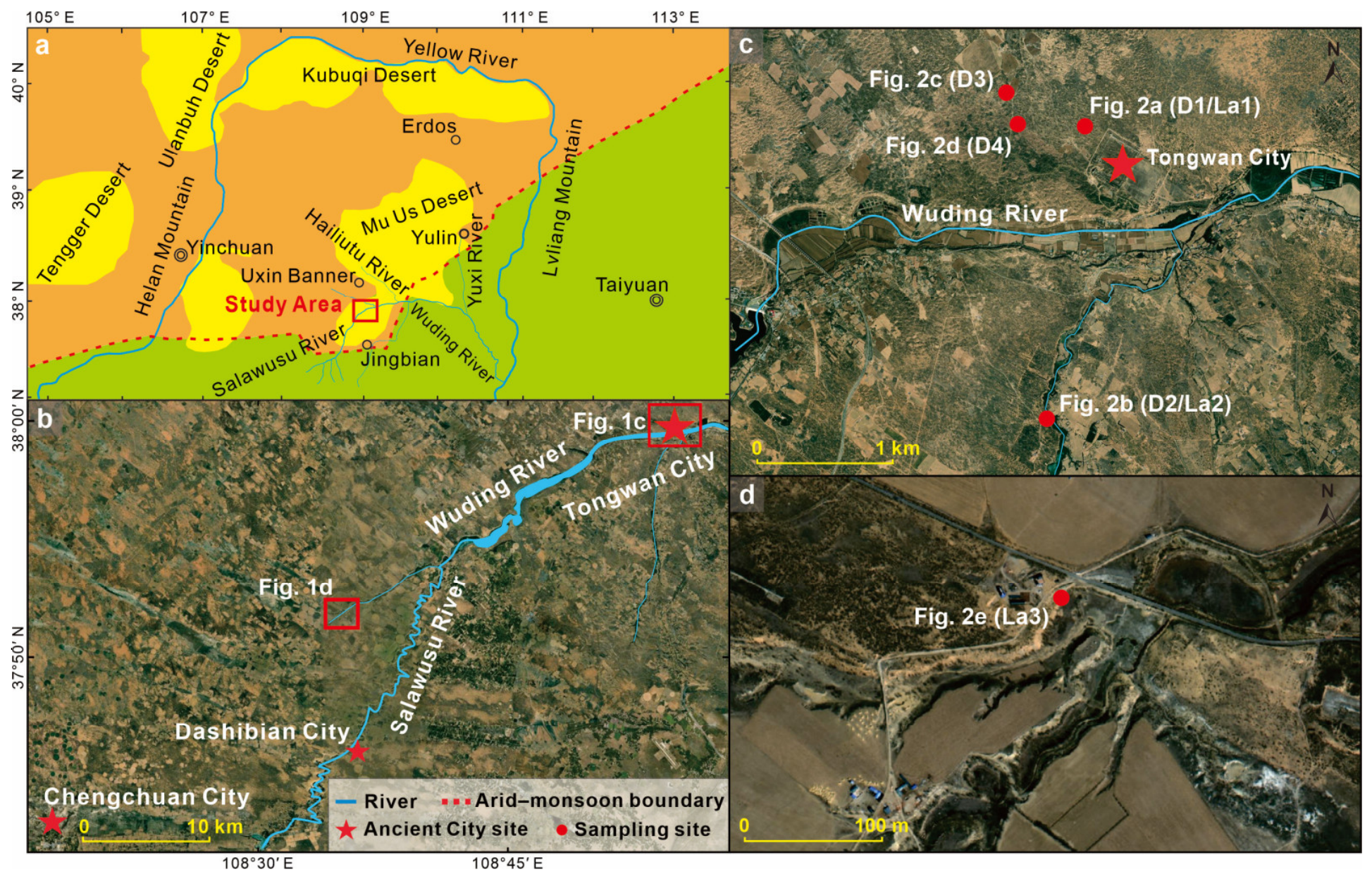
Tongwan City is situated on the northern bank of the Wuding River along the southeastern margin of the Mu Us Desert (38.00° N, 108.86° E), at an elevation of 1150–1162 m above sea level, with a height of approximately 40 m above the river level. It occupies an important position within the ecologically sensitive transitional zone between the East Asian monsoon region and the arid northwestern region of China (Figure 1). Tongwan City served as the capital of the Great Xia Kingdom and represents the only surviving capital-city archaeological site established by the Xiongnu in human history. Construction of the city began in AD 413 and was completed in AD 418, before being abandoned in AD 994 [14]. The city was established directly upon Holocene lacustrine deposits. The preserved structures consist entirely of rammed-earth architecture, characterized by massive construction, high durability, and a grayish-white appearance. The main source of materials is lacustrine sediment. The site includes the East City, the West City, and the Outer City [14,15]. The East City has a perimeter of 2566 m, whereas the West City has a perimeter of 2470 m. The Outer City exhibits an irregular L-shaped plan, with a perimeter of 13,865 m and an area of 7.7 km2. The foundation of the West City wall is about 16 m thick, reaching about 30 m when the projecting bastions (Mamian) are included, whereas the East City wall foundation is relatively thinner, ranging from 6 to 12 m in thickness.
Figure 1.
Geographical setting of the study area and distribution of sampling sites and paleolake sections ((a): location of the study area within the comprehensive natural regionalization of northern China; (b): satellite image of the Tongwan City site, the Wuding River, and the sampling areas; (c): detailed view of the Tongwan City site and adjacent paleolake sections; (d): detailed view of paleolake sections exposed along tributaries of the Wuding River).
Geomorphologically, the upper reaches of the Wuding River and its tributaries (including the Salawusu River, Hailiutu River, and Yuxi River) in the Jingbian, Uxin Banner, and Yulin region belong to a depression within the southeastern Ordos Plateau [16]. In this study, this region is collectively defined as the upper Wuding River Basin. From a tectonic perspective, the area is characterized by a graben-like depression similar to the Yinchuan Graben [17] and is herein referred to as the Wuding Graben.
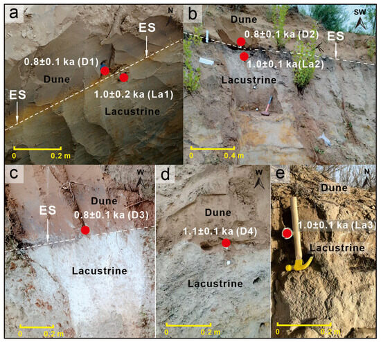
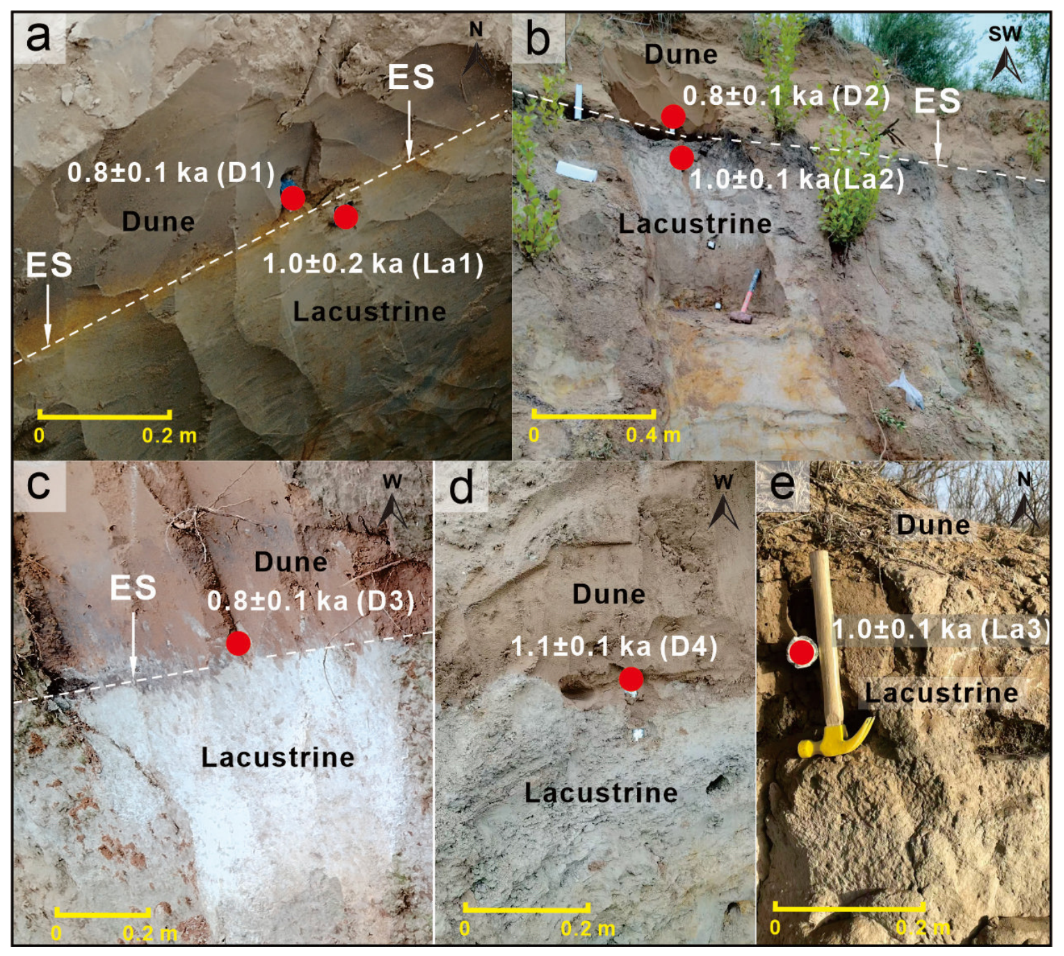
Tongwan City was built directly on extensive paleolake sediments within this graben. The thick and strongly compacted construction materials used for the city walls were obtained mainly from gray to light-gray sandy silt deposited by the paleolake. These lacustrine sediments are broadly exposed around the city and are commonly covered by ancient mobile dune sands. Four dune-sand samples (D1–D4) and two lacustrine sediment samples (La1 and La2) were taken from the uppermost part of the lacustrine deposits and from the contact boundary between the lacustrine sediments and the overlying dune sands in TWSA for OSL dating (Figure 1c). In addition, to examine whether the timing of lacustrine termination was consistent at a regional scale, another lacustrine sample (La3) was collected from the uppermost lacustrine deposits along a tributary of the upper Wuding River, several tens of kilometers southwest of Tongwan City (Figure 1d). Figure 2 shows the sampling locations within the sedimentary profiles, whereas the spatial distribution of the sampling sites is given in Figure 1. As indicated in Figure 1, the investigated TWSA profiles extend over an area of about 5 km2. During sampling, stainless-steel tubes with an inner diameter of 5 cm were pushed horizontally into freshly exposed sediment sections. The tubes were immediately sealed to avoid light exposure before laboratory treatment.
Figure 2.
Sampling profiles ((a–d): lacustrine deposits, overlying dune sands, and their contact interface in TWSA; (e): lacustrine deposits along a tributary of the upper Wuding River; ES: fluvial erosion surface; and the locations and ages of the OSL samples).
2.2. OSL Dating
Seven sediment samples were analyzed using OSL dating in this study, comprising four samples from the base of dune sands (D1–D4) and three from the top of lacustrine deposits (La1–La3). Sampling sites are presented in Figure 1, and the detailed stratigraphic horizons of individual samples are shown in Figure 2. The dune samples are predominantly composed of fine sand, whereas the lacustrine samples are mainly composed of silt. All sample pretreatment and analytical procedures were conducted at the Luminescence Geochronology Laboratory, Jiaying University.
Sample pretreatment was conducted under subdued red-light conditions. Carbonates and organic matter were first removed using 10% HCl (Guangzhou Chemical Reagent Factory, Guangzhou, China) and 30% H2O2 (Guangzhou Chemical Reagent Factory, Guangzhou, China), respectively. The samples were then dried, sieved, and treated by heavy-liquid separation to separate quartz and K-feldspar fractions within the required grain-size range. Quartz grains were etched with 40% HF (Guangzhou Chemical Reagent Factory, Guangzhou, China) for at least 45 min to remove the outer layer influenced by α irradiation, whereas K-feldspar grains were etched with 10% HF for at least 20 min. After etching, the samples were rinsed successively with 10% HCl and distilled water and then dried. Quartz purity was checked by comparing infrared-stimulated and blue-light-stimulated luminescence signals. Samples showing an infrared-to-blue signal ratio of <10% were considered sufficiently pure for OSL dating.
Equivalent doses (De) were measured using the single-aliquot regenerative-dose (SAR) protocol [18,19]. Luminescence measurements were performed with a Risø TL/OSL-DA-20 reader fitted with a 90Sr/90Y beta source, blue (470 nm) and infrared (830 nm) stimulation sources, a U-340 detection filter, and a photomultiplier tube (Technical University of Denmark-Nutech, Roskilde, Denmark). Environmental dose rates were estimated by considering the concentrations of radioactive elements (U, Th, and K), the contribution from cosmic radiation, and the moisture content of the burial environment. U and Th concentrations were analyzed using inductively coupled plasma mass spectrometry (Thermo Fisher Scientific (China) Co., Ltd., Shanghai, China), whereas K concentrations were measured using inductively coupled plasma atomic emission spectroscopy (Agilent Technologies, Santa Clara, CA, USA). The measured elemental concentrations were converted into equivalent radionuclide activities using standard conversion factors, and the contributions of α, β, and γ radiation to the environmental dose rate were then calculated [20]. The cosmic-ray dose rate was estimated according to sample latitude, longitude, elevation, and burial depth [21]. The water content was obtained from measured values and adjusted to 5 ± 1% to reflect long-term burial conditions.
3. Results and Discussion
3.1. Analysis of the OSL Dating Results
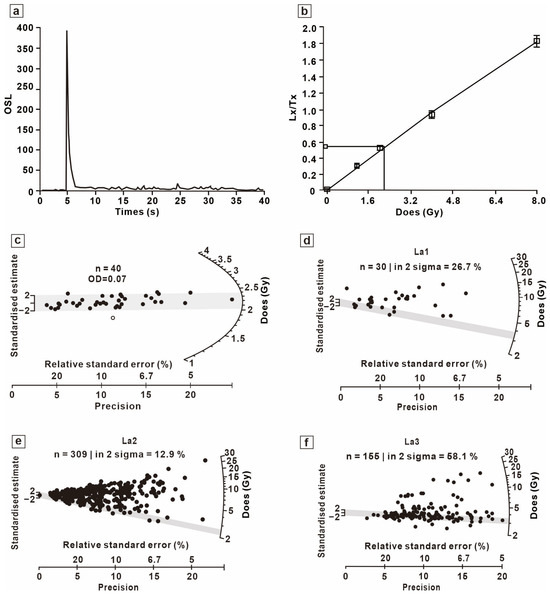
To confirm the reliability of the SAR protocol, a suitable preheating temperature was determined before luminescence measurements. Previous studies on quartz samples from the southern margin of the Mu Us Desert and nearby areas have shown that preheating at 240 °C for 10 s gives reliable De values based on preheat plateau and dose recovery tests [22]. Therefore, all samples in this study were preheated at 240 °C for 10 s, followed by a cut-heat temperature of 200 °C. The four aeolian sand samples showed bright quartz signals mainly controlled by the fast component, with signals rapidly decreasing to background levels. The dose–response curves passed near the origin, and the recycling dose points were closely matched with the regenerative dose points, while the natural dose points occurred within the well-defined part of the growth curves (Figure 3). In addition, the De values obtained from different aliquots of the same sample were tightly grouped (Figure 3), with overdispersion (OD) values all lower than 0.20, indicating that the quartz grains had been relatively well bleached before deposition.
Figure 3.
Luminescence characteristics and De distributions of samples ((a–c): luminescence signal decay curve, dose–response curve, and radial plot of De values for sample D4, respectively; (d–f): radial plots of single-grain K-feldspar De values for samples La1, La2, and La3, respectively).
For the paleo-lacustrine sediments, quartz De values displayed large dispersion, and the single-grain quartz luminescence signals were generally weak. Therefore, single-grain K-feldspar measurements were preferentially used. For these relatively young K-feldspar samples from the Wuding River Basin, De were obtained using the two-step post-infrared infrared stimulated luminescence protocol (pIRIR170) based on the SAR protocol [23]. Single-grain analyses were performed using gold-coated aluminum discs with 100 individual micro-holes, which allowed about 100 grains to be irradiated and measured at the same time during each measurement cycle. The single-grain K-feldspar data were filtered following the criteria proposed in previous studies [24]: (1) the initial test-dose signal exceeded the background intensity by at least 3σ, and/or the relative standard error was ≤20%; (2) the recycling ratio was between 0.9 and 1.1; (3) the infrared signal depletion ratio was between 0.9 and 1.1; (4) the thermal-transfer recuperation ratio for the maximum regenerative dose was <5%; and (5) the dose–response curve could be suitably fitted using an appropriate function. After quality screening, the De values of the accepted grains were assessed using the Minimum Age Model (MAM) [25], producing De estimates that most closely indicate the true burial ages of the samples (Figure 3d–f).
The OSL dating results are listed in Table 1, and the related ages are shown in Figure 2. As shown in Table 1, the OSL ages of the TWSA samples vary from 0.7 to 1.2 ka, with the analytical uncertainties for each sample presented in the table. In addition, the OSL age of sample La3, collected from the uppermost lacustrine deposits along a tributary of the upper Wuding River, was 1.0 ± 0.1 ka (Table 1; Figure 2), which is within the same age range as the TWSA samples. This consistency suggests that the disappearance of the paleolakes occurred as a regional-scale event.
Table 1.
OSL dating results for samples.
3.2. Disappearance of the Paleolakes and the Causes of the Abandonment of Tongwan City
Regarding the chronological boundary indicated by the contact interface, 1.2 ka is preferred, corresponding to the upper error limit of the OSL age of sample D4 (1.1 ± 0.1 ka; Table 1). This interpretation is supported by several kinds of evidence. First, among the four TWSA profiles, only the profile shown in Figure 2d preserves a clear and continuous stratigraphic sequence across the lacustrine–aeolian contact, whereas the other three profiles (Figure 2a–c) show different degrees of fluvial disturbance at the interface, forming clear fluvial erosion surfaces. Second, Bai et al. [26] divided the desertification history of the Mu Us Desert during the past 2 ka into three stages and identified the second desertification stage as occurring between AD 840 and 960 (1186–1066 yr BP). The beginning of this stage closely matches the interface age used in this study (1.2 ka BP), supporting the reliability of the selected age within the regional environmental evolution sequence. Third, historical records from the Tang Dynasty show that as early as AD 818 (1204 yr BP), Tongwan City had already suffered serious aeolian activity, as described by phrases such as “strong winds piled drifting sand as high as the city battlements,” “wind-blown sand filled the eyes with despair,” and “the vast sandy wilderness gradually engulfed Helian’s city” [8]. These historical descriptions are also in agreement with the inferred age of the sedimentary interface.
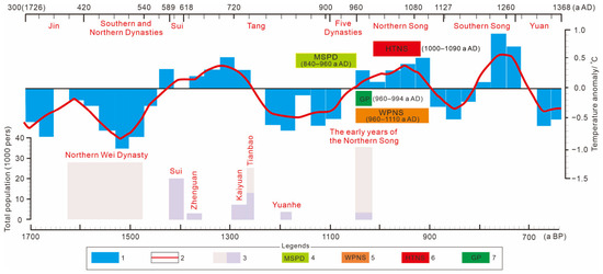
Based on the above evidence, the sedimentary facies change across the interface can be considered the local expression within the TWSA of wider environmental changes affecting the whole Mu Us Desert. Therefore, this facies transition probably represents the beginning of the Second Mu Us Desert Sandification event (MSSD). If this interpretation is reasonable, Tongwan City, as part of the Mu Us Desert region, had already experienced the complete environmental stress related to this second desertification stage before its final abandonment. Compared with the winter-half-year temperature reconstruction for eastern China (east of 105° E and between 25° N and 40° N) since AD 300 [27,28] (Figure 4), the timing of the second MSSD closely corresponds to the Tang–Five Dynasties cold period (AD 750–950), during which temperature anomalies remained in a clear negative range of −0.5 to 0 °C. The cold and dry climatic conditions during this period may explain why the demographic history of Tongwan City showed a period of zero population growth between the Tang Yuanhe period and the Song Dynasty (AD 820–960) [8] (Figure 4). These results indicate a strong relationship among climatic fluctuations, especially cold intervals, the disappearance of the TWSA paleolakes and the related desertification recorded in the sediments, and the long-term stagnation of regional population growth.
Figure 4.
Comparison of winter-half-year temperatures in China and eastern China, population changes in Tongwan City, and the environmental evolution of Tongwan since AD 300. (1 and 2 show the variations in the 30-year anomaly and the moving average of temperature over eastern China during the winter half-year from October to April of the following year, respectively [27,28]; 3 shows dynasties with available population records, where grayish-white and light purple represent agricultural and pastoral populations of Tongwan City, respectively [8]; 4 indicates the timing of the second desertification event in the Mu Us Desert [26]; 5 denotes the Warm Period of the Northern Song (WPNS) proposed in this study; 6 denotes the High-Temperature Period of the Northern Song (HTNS); and 7 denotes the Grasslandification Period (GP)).
It is noteworthy that, following this interval of marked population decline, the early Northern Song Dynasty (AD 960–1110; 1032–916 yr BP) experienced a sustained phase of positive temperature anomalies exceeding 0 °C for about 150 years. This interval is referred to here as the WPNS. During the initial decades of the WPNS, immediately prior to the abandonment of Tongwan City (AD 960–994), the population of the city increased dramatically within only about thirty years to more than 35,000 inhabitants, including 3494 agricultural residents and 32,150 pastoral residents, yielding an agricultural-to-pastoral population ratio of about 1.1:10. Over the same period, the reconstructed temperature anomaly rose from 0 °C to +0.20 °C (Figure 4). These observations indicate that moderate climatic warming during the early WPNS facilitated the expansion of grassland ecosystems both within the TWSA and across the surrounding region, a stage defined here as the Grasslandification Period (GP). This environmental transition likely prolonged the growing season, supported the ecological recovery of previously desertified landscapes, and promoted the development of extensive and highly productive grasslands, thereby enabling an unprecedented expansion of pastoralism. At the same time, agricultural productivity also increased markedly, providing a stable ecological and material basis capable of sustaining a large regional population. These environmental and demographic changes were evidently driven primarily by climatic conditions.
However, a detailed comparison between the temperature and population curves (Figure 4) indicates that climate alone cannot fully explain the final abandonment of Tongwan City. The main paradox can be stated as follows. If the rapid population increase during the early Northern Song Dynasty, after an earlier stage of population stagnation, was caused by higher temperatures through improved ecological carrying capacity and longer growing seasons, why was Tongwan City still destroyed and abandoned in AD 994? Moreover, for 115 years after the abandonment of the city, eastern China during the Northern Song Dynasty remained within the WPNS. From AD 994, temperatures stayed above +0.20 °C for almost one century (AD 994–1094; 1032–932 yr BP), with a highest anomaly of +0.40 °C around AD 1060 (966 yr BP). This interval is defined in this study as the HTNS. Similar warm stages also appeared during the Southern Song Dynasty and extended into the following century of climatic warming. According to IPCC assessments of global warming since 1850, hydrothermal conditions during the WPNS were actually more suitable than those at present. However, after its abandonment, Tongwan City remained an uninhabited “empty city” covered by sands and did not revive, even during the century-long HTNS or later climatic warming. This contradiction led to an investigation of the characteristics and strength of late Quaternary neotectonic activity in the region, showing that long-term regional tectonic uplift, which greatly changed the regional hydrological system, may have been the main cause of the permanent abandonment of Tongwan City [3,29].
The geological mechanism can be explained as follows. Among the four sedimentary profiles examined within the TWSA (Figure 2a–d), fluvial erosion surfaces were developed between the lacustrine deposits and the overlying dune sands in three profiles, except that shown in Figure 2d. More importantly, the dune sands directly covering these erosion surfaces gave highly consistent OSL ages of 0.8 ± 0.1 ka BP. The synchronous formation of erosion surfaces with the same age in several profiles suggests that their development was controlled by a common regional geological process, namely the tectonic uplift event discussed above, which caused a sudden reorganization of the regional hydrological system. This tectonic event is preserved in the sedimentary sequence as a clear depositional hiatus between 1.1 ± 0.1 ka BP and 0.8 ± 0.1 ka BP. Field evidence and previous studies further demonstrate that fluvial coarse sands occur on the valley tops of the upper Wuding River, which sustained strong hydrodynamic activity at ~0.7 ka BP [30]. In addition, the highest terrace along the river may younger than ~2 ka [2], and the lowest terraces preserve ceramic and pottery sherds less than ~0.8 ka in age [31]. These lines of geomorphic and archaeological evidence consistently indicate that river incision along the Wuding River occurred in the recent past, which aligns well with the interpretation of tectonically driven river downcutting and consequent groundwater decline. Comparison with the regional temperature and population records during this interval (Figure 4) gives further information. During the MSSD (AD 840–960; 1186–1066 yr BP), temperature anomalies remained continuously below 0 °C, and the cold climate strongly reduced surface runoff. Therefore, even if tectonic uplift had already occurred, regional-scale fluvial incision would probably not have developed. By contrast, during the following GP (AD 961–994; 1065–1032 yr BP), when temperatures increased again and hydrothermal conditions became favorable, if tectonic uplift had already started fluvial incision, the groundwater decline over several decades would have conflicted with the rich water resources needed to support the population growth during the early Northern Song Dynasty. Thus, regional-scale fluvial erosion required a critical environmental threshold, that is the combination of sufficient hydrothermal conditions able to maintain surface runoff and continuous tectonic uplift supplying the geomorphic driving force for erosion. On this basis, a logically reasonable interpretation can be proposed: the fluvial erosion surfaces formed within the TWSA because of tectonic uplift represent the geological precursor of the HTNS. During this period, the combined action of very favorable hydrothermal conditions and regional tectonic uplift produced the depositional hiatus preserved between the lacustrine deposits and the overlying dune sands. This process was likely the basic reason why Tongwan City was finally abandoned at the beginning of the HTNS in AD 994 (1032 yr BP).
From a geological viewpoint, differential crustal uplift within the TWSA directly promoted the fast development of surrounding external drainage systems, especially the strong incision of the Wuding River valley. As a result, even under the favorable hydrothermal conditions of the HTNS, effective drainage prevented surface runoff from maintaining a stable lacustrine environment. In addition, population growth and agricultural land reclamation during the early Northern Song Dynasty and earlier historical periods probably accelerated the disappearance of the paleolakes. The Holocene lacustrine deposits below the lacustrine–dune sand contact in the TWSA form a regionally extensive aquitard, beneath which several tens of meters of permeable sandy strata of the Chengchuan Formation occur. Besides the direct damage to the aquitard during the construction of Tongwan City, long-term human activities further changed the lacustrine sediments and produced dense fracture networks and permeable channels that worked as an underground artificial drainage system. As regional tectonic uplift continued and river valleys became increasingly incised, even the abundant precipitation of the HTNS could not stop rapid infiltration and drainage of surface water through this subsurface drainage network. Consequently, the paleolakes disappeared, followed finally by the complete abandonment of Tongwan City and the loss of its population. It is therefore reasonable to infer that the abandonment of Tongwan City began with the onset of the HTNS. The identification of this interval is supported not only by the accurate chronological constraints from the sedimentary record but also by the clear match between sedimentary facies and climatic changes. After the WPNS, the climatic reconstruction shown in Figure 4 records a long 90-year cold interval (AD 1110–1200; 916–826 yr BP), during which temperature anomalies remained below 0 °C. Notably, the OSL age of about 0.9 ka BP obtained from the dune sands covering the sedimentary interface, which indicate a cold, dry, and windy depositional environment, falls exactly within this cold climatic interval.
The recognition of the climate–tectonics–sedimentation synergistic mechanism in the TWSA is based on a broad understanding of environmental evolution in the upper Wuding River Basin, which is located in the climatically sensitive transition zone between the East Asian summer and winter monsoon systems. Previous studies have shown that the interaction between climate and tectonics has an important control on the regional sedimentary environment. Under relatively warm climatic conditions together with tectonic subsidence, increased summer monsoon rainfall promotes humid environments suitable for the formation of fluvial and lacustrine deposits. This relationship has been well recorded in the Salawusu River Basin. During the Late Pleistocene, under a graben tectonic setting, the basin preserved an almost continuous fluvial–lacustrine sedimentary sequence that recorded millennial-scale interstadial summer monsoon fluctuations in the Northern Hemisphere [32]. In contrast, when relatively warm climatic conditions occur together with tectonic uplift, the regional sedimentary environment follows a very different evolutionary pattern. This change is especially clear during the historical period. A recent study by Wen et al. [2] showed that, since about 1700 yr BP (AD 300), neotectonic uplift and related river incision in the Salawusu River Basin directly caused the collapse of the Chengchuan paleolake, giving strong geological evidence for sedimentary responses driven by climate–tectonics interaction. More importantly, recent studies of groundwater evolution at the Dashibian Ancient City, located about 40 km southwest of Tongwan City, showed that between about 700 and 800 yr BP, rapid river incision of about 60 m occurred together with a synchronous groundwater decline of 33–35 m [3,29]. Similarly, the three levels of tectonic strath terraces developed along the Wuding River within the TWSA provide clear geomorphic evidence for regional differential crustal uplift. The groundwater decline of 33–35 m reconstructed for Dashibian Ancient City closely matches the present groundwater depth of about 40 m below the highest terrace of Wuding River in the TWSA, showing strong spatial consistency. This relationship indicates that the combined action between the climatic system and tectonic processes was an unavoidable and objective control on environmental evolution in this region. Overall, this multi-scale evidence shows that climate–tectonics synergistic effects in the TWSA during the HTNS represented a catchment-scale geological process. These findings also provide important environmental geological support for the conclusion that Tongwan City had already been abandoned at the beginning of the WPNS.
4. Conclusions and Future Perspectives
- (1)
- OSL dating reveals that the disappearance of the paleolakes and the start of desertification in the TWSA occurred between about 1.2 ka and 0.9 ka BP. This age range is consistent with both the historically recorded abandonment of Tongwan City in AD 994 and the regional desertification that has occurred since the late Tang Dynasty, suggesting that the disappearance of the paleolakes was the direct environmental trigger for the abandonment of the ancient city.
- (2)
- The abandonment of Tongwan City was caused by the synergistic interaction between regional tectonic uplift and the hydrothermal conditions during the HTNS. Uplift promoted the incision of the Wuding River and the abundant precipitation during the HTNS both strengthened surface runoff drainage and damaged the lacustrine aquitard, thereby forming seepage pathways and causing rapid groundwater loss. As a result, regional groundwater levels decreased by about 30–40 m, the paleolakes could no longer be maintained, and the ancient city was finally abandoned because of the loss of its water resources.
- (3)
- The environmental evolution of the TWSA was not an isolated phenomenon. Similar evidence of river incision and groundwater decline at about 1000 yr BP has been reported across the upper Wuding River Basin, including the Salawusu River Basin and Dashibian Ancient City. These observations show that, within the climatically sensitive transition zone affected by both the East Asian winter and summer monsoon systems, the coupling between climatic fluctuations and neotectonic activity formed the driving mechanism controlling regional environmental evolution and the rise and decline of human settlements.
It should be noted that, owing to the limited sampling area (~5 km2) and restricted field outcrop conditions (five sections available), future work is required to obtain additional dating data from more profiles across a broader region in order to verify the regional consistency of the sedimentary interface. In addition, independent quantitative constraints on parameters such as the rates of regional tectonic uplift and river incision are currently lacking. Meanwhile, direct geological evidence is still absent concerning the destruction of the lacustrine aquiclude by human activities. Future research should strengthen efforts in these aspects, so as to achieve a more comprehensive understanding of the complex mechanisms driving ancient lake demise and settlement abandonment in arid regions under the combined effects of climate, tectonics, and human activities.
Author Contributions
Conceptualization, Y.Y., R.H., B.L., Y.S. and L.H.; Methodology, Y.Y., R.H., B.L., R.G., Y.S. and L.H.; Software, Y.Y., R.H., B.L. and L.H.; Validation, Y.Y., R.H., B.L., Y.S. and L.H.; Formal analysis, Y.Y., R.H., B.L., Y.S. and L.H.; Investigation, Y.Y., R.H., B.L., R.G., Y.S. and L.H.; Resources, Y.Y., R.H., B.L., R.G., Y.S. and L.H.; Data curation, Y.Y., R.H., B.L., R.G., Y.S. and L.H.; Writing—original draft, Y.Y., R.H., B.L. and L.H.; Writing—review & editing, Y.Y., R.H., B.L. and L.H.; Visualization, Y.Y., B.L., Y.S. and L.H.; Supervision, Y.Y., R.H., B.L., R.G., Y.S. and L.H.; Project administration, Y.Y., B.L., R.G., Y.S. and L.H.; Funding acquisition, Y.Y., B.L., Y.S. and L.H. All authors have read and agreed to the published version of the manuscript.
Funding
This research was funded by the National Natural Science Foundation of China, grant number [42302212], and the Agreement between Lingnan Normal University and Kangbashi Nature Exploration Center on Enhancing the Center’s Scientific Research Capability and Influence, grant number [NXSZ2026002].
Data Availability Statement
The original contributions presented in this study are included in the article. Further inquiries can be directed to the corresponding author.
Conflicts of Interest
The authors declare no conflicts of interest.
References
- Liu, X.K.; Lu, R.J.; Jia, F.F.; Chen, L.; Li, T.F.; Ma, Y.Z.; Wu, Y.Q. Holocene water-level changes inferred from a section of fluvio-lacustrine sediments in the southeastern Mu Us Desert, China. Quat. Int. 2018, 469, 58–67. [Google Scholar] [CrossRef] [Scilit]
- Wen, Y.S.; Li, B.S.; Niu, D.F.; Bai, Q.Y.; Wang, F.N.; Si, Y.J.; Chen, M. Range, termination timing and formation mechanisms of the Chengchuan Paleolake in the Mu Us Desert. Geol. Rev. 2026, 72, 461–469. [Google Scholar]
- Wang, W.; Li, B.S.; Wen, X.H.; Xu, L.B.; Huang, R.H.; Feng, J.; Qiu, M.Q. Abandonment of ancient cities near the Salawusu River valley, China, triggered by stream capture. Commun. Earth Environ. 2022, 3, 326. [Google Scholar] [CrossRef] [Scilit]
- Zhao, Y.F. Some Problems Concerning the Evolution of the Mao Wu Su Desert in History. Chin. Hist. Geogr. 1981, 34–47. [Google Scholar]
- Li, E.J.; Xie, C.L. Discuss on causes of abandonment of Tongwan City in South of Mu Us sand land. J. Desert Res. 2010, 30, 1047–1052. [Google Scholar]
- Chen, F.H.; Fu, B.J.; Xia, J.; Wu, D.; Wu, S.H.; Zhang, Y.L.; Sun, H.; Liu, Y.; Fang, X.M.; Qin, B.Q.; et al. Major advances in studies of the physical geography and living environment of China during the past 70 years and future prospects. Sci. China Earth Sci. 2019, 62, 1665–1701. [Google Scholar] [CrossRef] [Scilit]
- Hou, R.Z. Changes of the Mu Us Desert in light of the remains of an ancient city on the Hongliu River. Cult. Relics 1973, 35–41. [Google Scholar] [CrossRef]
- Deng, H.; Xia, Z.K.; Wang, B.Y. Human Activities’ Influence on the Areas of Weak Ecological Environment in Terms of the Rise and Fall of tongwan City. Collect. Pap. Chin. Hist. Geogr. 2001, 16, 104–113+126. [Google Scholar]
- Shi, N.H. The distribution and changes of agricultural, forestry, and pastoral areas on the Ordos Plateau and the Hetao Plain over the past 2,300 years. J. Beijing Norm. Univ. 1980, 16, 1–14. [Google Scholar]
- Cheng, X. Relationship between agriculture, ecological deterioration, restoration and reconstruction in Loess Plateau areas of northwest China. Sci. Agric. Sin. 2001, 34, 84–90. [Google Scholar]
- Hu, J. The historical evolution of the ancient city of Great Xia–Tongwan City. J. Shanxi Norm. Univ. 2011, 38, 66–68. [Google Scholar]
- Wang, S.Y.; Dong, J.B. The rise and fall of Tongwan city with the environmental change of Mu Us Sandy Land. Geogr. Res. 2001, 20, 347–353. [Google Scholar]
- Cui, J.X.; Chang, H. The possible climate impact on the collapse of an ancient urban city in Mu Us Desert, China. Reg. Environ. Change 2013, 13, 353–364. [Google Scholar]
- Dai, Y.X. Survey Record of the Tongwan City Site. Archaeology 1981, 225–232, 297–298. [Google Scholar]
- Gao, Z. Tongwan City Ruins, Yulin City, Shaanxi Province, Sixteen Kingdoms. Res. Conserv. Cave Temples Earthen Sites 2024, 3, 2. [Google Scholar]
- Yang, L.H. Quaternary Geological Survey Report of Ordos. Quaternary Geological Survey Report of the Middle Reaches of the Yellow River; Science Press: Beijing, China, 1962; pp. 221–254. [Google Scholar]
- Pei, W.Z.; Li, Y.H. Some tentative opinions on the problem of “sjara-osso-gol series”. Vertebr. Palasiat. 1964, 99–118. [Google Scholar]
- Murray, A.S.; Wintle, A.G. Luminescence dating of quartz using an improved single-aliquot regenerative dose protocol. Radiat. Meas. 2000, 32, 57–73. [Google Scholar] [CrossRef] [Scilit]
- Wintle, A.G.; Murray, A.S. A review of quartz optically stimulated luminescence characteristics and their relevance in single-aliquot regeneration dating protocols. Radiat. Meas. 2006, 41, 369–391. [Google Scholar] [CrossRef] [Scilit]
- Aitken, M.J. An Introduction to Optical Dating; Oxford University Press: London, UK, 1998; pp. 39–44. [Google Scholar]
- Prescott, J.R.; Hutton, J.T. Cosmic ray contributions to dose rates for luminescence and ESR dating: Large depths and long-term time variations. Radiat. Meas. 1994, 23, 497–500. [Google Scholar] [CrossRef] [Scilit]
- Huang, L.; Du, Q.M.; Li, M.Q.; Gusiletu; Si, Y.J.; Huang, R.H.; Hang, X.J.; Niu, D.F. OSL dating of typical eolian sand profiles in the Mu Us Sandy Land since 12.6 ka and its significance. Arid. Zone Res. 2025, 42, 1681–1690. [Google Scholar]
- Xie, J.R.; Wen, X.H.; Ou, X.J.; Niu, D.F.; Wang, S.S.; Qiu, M.K. K-feldspar single-grain post-IR IRSL dating of modern dune sand in the Salawusu River Valley. J. Desert Res. 2024, 44, 135–145. [Google Scholar]
- Jacobs, Z.; Duller, G.A.T.; Wintle, A.G. Interpretation of single grain De distributions and calculation of De. Radiat. Meas. 2006, 41, 264–277. [Google Scholar] [CrossRef] [Scilit]
- Galbraith, R.F.; Roberts, R.G.; Laslett, G.M.; Yoshida, H.; Olley, J.M. Optical dating of single and multiple grains of quartz from Jinmium rock shelter, Northern Australia: Part I, experimental design and statistical models. Archaeometry 1999, 41, 339–364. [Google Scholar] [CrossRef] [Scilit]
- Bai, Z.Z.; Cui, J.X. Desertification and its causes in Mu Us Desert in recent 2000 years. J. Desert Res. 2019, 39, 177–185. [Google Scholar]
- Zheng, J.Y.; Wang, S.W. Assessment on Climate Change in China for the Last 2000 Years. Acta Geogr. Sin. 2005, 60, 21–31. [Google Scholar]
- Ge, Q.S.; Liu, H.L.; Ma, X.; Zheng, J.Y.; Hao, Z.X. Characteristics of temperature change in China over the last 2000 years and spatial patterns of dryness/wetness during cold and warm periods. Adv. Atmos. Sci. 2017, 34, 941–951. [Google Scholar] [CrossRef] [Scilit]
- Wen, P.H.; Wang, N.A.; Wang, Y.X.; Huang, Y.Z.; Cheng, H.Y.; He, T.H. Fluvial incision caused irreversible environmental degradation of an ancient city in the Mu Us Desert, China. Quat. Res. 2021, 99, 1–13. [Google Scholar] [CrossRef] [Scilit]
- Ding, Z.Y.; Lu, R.J.; Fan, X.M.; Liu, X.K.; Pu, J.; Shen, Y.P.; Zhang, J.P. Geochemical evidence for changes in provenance and paleoclimate during the Holocene obtained from a fluvial–eolian sequence in the southern Mu Us Desert, north-central China. Geoderma 2024, 444, 116860. [Google Scholar] [CrossRef] [Scilit]
- Yuan, B.Y. Sedimentary environment and stratigraphical subdivision of Sjara Osso-Gol Formation. Chin. J. Geol. 1978, 46, 427–440. [Google Scholar]
- Li, B.S. East Asian monsoon variability recorded in desert areas. In Late Cenozoic Climate Change in Asia: Loess, Monsoon and Monsoon-Arid Environment Evolution; An, Z.S., Ed.; 3.9. Dordr. Springer Sci. + Bus. Media; Springer: Berlin/Heidelberg, Germany, 2014; pp. 252–280. [Google Scholar]

Disclaimer/Publisher’s Note: The statements, opinions and data contained in all publications are solely those of the individual author(s) and contributor(s) and not of MDPI and/or the editor(s). MDPI and/or the editor(s) disclaim responsibility for any injury to people or property resulting from any ideas, methods, instructions or products referred to in the content. |
© 2026 by the authors. Licensee MDPI, Basel, Switzerland. This article is an open access article distributed under the terms and conditions of the Creative Commons Attribution (CC BY) license.