Article

From Monitoring to Remediation: An Integrated Decision-Support Framework for the Ternopil Reservoir Under Multiple Environmental Stressors


by
Sérgio Lousada
1,2,3,4,5,6,*,
Oleksandr Bondar
7,
Leonid Bytsyura
7,
Svitlana Delehan
6,8,
Dainora Jankauskienė
9 and
Vivita Pukite
10
1
Department of Civil Engineering and Geology (DECG), Faculty of Exact Sciences and Engineering (FCEE), University of Madeira (UMa), 9000-082 Funchal, Portugal
2
Centro de Investigação, Desenvolvimento e Inovação em Turismo-Madeira-Research Centre for Tourism Development and Innovation, 9000-082 Funchal, Portugal
3
VALORIZA-Research Centre for Endogenous Resource Valorization, Polytechnic Institute of Portalegre (IPP), 7300-110 Portalegre, Portugal
4
Research Group on Environment and Spatial Planning (MAOT), University of Extremadura, 06071 Badajoz, Spain
5
RISCO—Civil Engineering Department, University of Aveiro, 3810-193 Aveiro, Portugal
6
OSEAN—Outermost Regions Sustainable Ecosystem for Entrepreneurship and Innovation, 9000-082 Funchal, Portugal
7
Department of Ecology and Health Protection, Educational and Scientific Institute of Innovation, Environmental Management and Infrastructure, West Ukrainian National University, 11, Lvivska St., 46009 Ternopil, Ukraine
8
Centre for Interdisciplinary Research of Uzhhorod National University, Uzhhorod National University, 88000 Uzhhorod, Ukraine
9
Environment and Civil Engineering Department, Klaipėdos Valstybinė Kolegija/Higher Education Institution, Bijunu Str. 10, 91223 Klaipeda, Lithuania
10
Department of Land Management and Geodesy, Latvia University of Life Sciences and Technologies, LV-3001 Jelgava, Latvia
*
Author to whom correspondence should be addressed.
Water 2026, 18(11), 1273; https://doi.org/10.3390/w18111273
Submission received: 24 March 2026 / Revised: 11 May 2026 / Accepted: 22 May 2026 / Published: 25 May 2026

Abstract

Urban reservoirs are increasingly exposed to multiple interacting pressures associated with eutrophication, pollutant inflow, ageing sewerage and stormwater infrastructure, and climate-related hydrological instability. This issue is of growing concern because municipalities often possess fragmented monitoring and planning evidence without an operational framework for translating it into remediation action. This study develops an integrated decision-support framework for the Ternopil Reservoir based primarily on recent hydrochemical monitoring data, complemented by historical targeted sampling and local environmental and planning materials. The analysis focuses on the most informative indicators of ecological deterioration in an urban reservoir, including oxygen regime, organic pollution, nutrient-related parameters, suspended solids, and selected pollution markers. The available evidence indicates that the Ternopil Reservoir is among the most environmentally stressed water bodies within the local reservoir system, with recurrent eutrophication symptoms, seasonal water blooming, and spatially differentiated exceedances of selected water-quality indicators. The results further indicate persistent nutrient-related and organic pressure, pronounced hydrochemical tension in 2022, and hotspot vulnerability in hydraulically weak sectors of the reservoir. To address these pressures, the study proposes a four-stage monitoring-to-remediation framework that links environmental diagnosis with the identification of vulnerable zones, the prioritisation of hydraulic and hydrobiological measures, and post-remediation control. The proposed framework is intended as an operational planning tool for translating fragmented local evidence into a coherent remediation pathway for urban reservoirs under multiple environmental stressors.

1. Introduction

Urban water bodies are increasingly recognised as critical hydroecological systems in which environmental degradation, infrastructure stress, and climate-related instability converge in visible and measurable form. In rapidly urbanising territories, reservoirs and regulated river reaches perform multiple functions, including flow regulation, recreation, landscape structuring, microclimatic buffering, and support of urban ecosystem stability. At the same time, such systems are highly vulnerable to nutrient enrichment, low-flow stagnation, stormwater-driven pollutant inflow, oxygen depletion, and seasonal ecological imbalance [1]. Urban reservoirs should therefore be understood not merely as passive recipients of contamination, but as sensitive indicators of dysfunction within the wider urban catchment [2].
This challenge is especially relevant in Ukraine, where environmental monitoring and water governance are being reshaped under the combined pressure of European integration, infrastructure deterioration, climate adaptation needs, and broader socio-environmental instability. In practice, however, local decision-making often relies on fragmented evidence. Hydrochemical observations, infrastructure assessments, environmental protection programmes, and climate-planning documents are commonly developed within separate administrative and sectoral frameworks and are rarely translated into a unified management logic [3]. As a result, municipalities may detect environmental deterioration but still lack a structured pathway from diagnosis to justified intervention. This limitation is particularly important in urban reservoirs, where degradation rarely results from a single source and instead emerges from the cumulative interaction of upstream inflow, diffuse urban runoff, sewerage deficiencies, hydraulic alteration, and in-reservoir biogeochemical processes [4].
In the Ukrainian context, the need for integrated water management is further intensified by multiple environmental pressures, including those exacerbated by wartime conditions and infrastructure stress [5]. Under such conditions, water monitoring becomes increasingly important as a basis for environmental diagnostics, infrastructure planning, and adaptive response at the local level [6].
The Ternopil Reservoir provides a representative case of a multi-stressor urban hydroecosystem. As such, it may also be regarded as a case-study example of a broader category of urban reservoirs exposed to interacting pressures associated with eutrophication, infrastructure deterioration, diffuse runoff, and hydrological instability. Although artificial in origin, it has evolved into a complex ecological system embedded within a broader urbanised river corridor. Its environmental condition is shaped not only by the characteristics of the impounded water body itself, but also by catchment-scale runoff formation, pollutant transport from upstream sections of the Seret River, municipal wastewater and urban runoff, and internal processes governed by hydraulic regime, temperature, oxygen conditions, and nutrient cycling [7]. In this respect, the reservoir illustrates how a local urban water body may become a focal point where watershed-scale pressures are transformed into localised ecological risk [8]. For this reason, the present case is relevant not only for local environmental management but also for understanding comparable urban reservoirs in other regions facing overlapping hydroecological and infrastructural stressors. Available local environmental materials further indicate that the Ternopil Reservoir is among the most environmentally stressed water bodies within the Ternopil urban territorial community [7,8]. Broader regional hydroecological studies reinforce the relevance of this case-study setting [9,10].
The deterioration of the reservoir cannot be explained through water chemistry alone. It is closely linked to the infrastructural condition of the surrounding urban environment and to broader water-governance challenges [10]. Local planning and programme documents point to substantial wear of water-supply and sewerage networks, incomplete sewerage coverage in some areas, outdated wastewater treatment approaches, and the absence of effective systems for stormwater and snowmelt drainage and treatment across large parts of the city [11]. These deficiencies increase the probability of uncontrolled or insufficiently treated pollutant inflow, amplify the effects of heavy rainfall, and reduce the adaptive capacity of the urban water system. In parallel, local climate-planning materials indicate growing pressure from extreme heat, drought, reduced water availability, and intense precipitation and flooding [12].
Under these conditions, remediation is more complex than periodic algae removal or isolated technical intervention. What is required is a transition from reactive maintenance to monitoring-informed environmental governance. In practical terms, this means linking diagnosis of ecological deterioration with the identification of vulnerable zones, the prioritisation of feasible hydraulic and hydrobiological responses, and post-intervention control capable of supporting adaptive correction [13]. Although local remediation-oriented materials already contain important elements of such an approach, including aeration, ecological treatment measures, drainage improvements, and follow-up monitoring, these components remain dispersed across separate technical and planning documents and have not yet been integrated into a single analytical structure explicitly connecting evidence, pressure pathways, intervention priorities, and response sequencing [14].
Accordingly, the central gap addressed by this study is not the absence of local environmental information, but the absence of an integrated operational framework for using that information strategically [15]. Despite the availability of hydrochemical observations, environmental assessments, municipal environmental programmes, and climate-planning materials, there is still no coherent structure for translating fragmented evidence into a practical remediation pathway for the Ternopil Reservoir under multiple environmental stressors. This gap limits the ability of local authorities to prioritise actions, coordinate ecosystem-based and infrastructural measures, and respond to reservoir degradation in a systematic rather than reactive manner [16,17].
Against this background, the aim of this study is to assess the hydrochemical condition of the Ternopil Reservoir, identify its major hotspot zones and pressure pathways, and develop an integrated decision-support framework for remediation planning under multiple environmental stressors. The study is based primarily on recent hydrochemical monitoring data, complemented by historical targeted sampling and local environmental, infrastructural, and planning materials. The contribution of the study does not lie in proposing a completely new generic decision-support architecture, but in adapting and operationalising established decision-support logic for a data-limited urban reservoir context. More specifically, the framework advances current applied practice by integrating three evidence layers that are rarely used together within a single municipal workflow: official hydrochemical monitoring data, historical hotspot-oriented sampling, and local environmental and planning materials. Its novelty lies in operationalising a monitoring-to-remediation logic for an urban reservoir affected by eutrophication, pollutant inflow, infrastructure deficiencies, climate-related hydrological stress, and broader war-related environmental vulnerability. Its practical contribution lies in providing a structured basis for identifying priority interventions, sequencing local remediation measures, and supporting more coherent urban water governance in municipalities facing comparable hydroecological pressures.

2. Materials and Methods

2.1. Study Area and Research Design

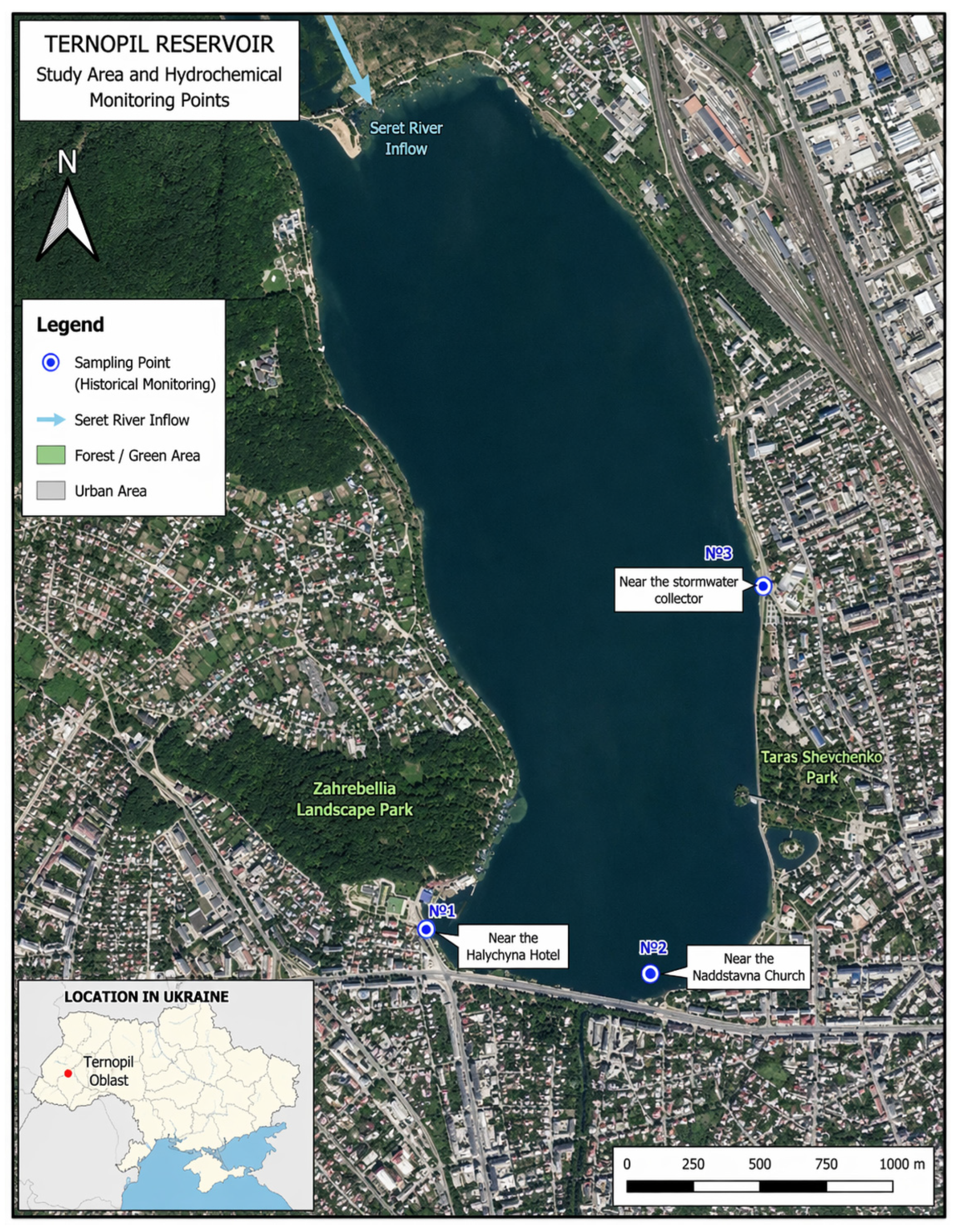
The study focused on the Ternopil Reservoir as the ecological core of a broader urban hydroecosystem formed within the Seret River corridor and functionally connected with upstream water bodies, urban runoff pathways, and surrounding anthropogenically transformed territories. The location of the study area within Ukraine and the positions of the historical hydrochemical sampling points used in the study are shown in Figure 1. Within this conceptual framing, the reservoir was treated not as an isolated impounded water body, but as a hydrologically and ecologically interconnected system whose environmental condition is shaped by catchment-scale runoff formation, pollutant transport from upstream sections of the Seret River, municipal wastewater and stormwater inputs, and internal in-reservoir processes governed by water exchange intensity, temperature regime, and oxygen availability [18]. Regional environmental reporting further situates the Ternopil Reservoir within the broader environmental context of Ternopil Oblast and supports the relevance of analysing local water bodies as part of regional environmental management [19]. This interpretation is consistent with local remediation-oriented analytical materials, which define the Ternopil Reservoir as the ecological nucleus of a larger urban water system with pronounced seasonal hydrological, hydrochemical, and hydrobiological variability [20].
The research was designed as an integrated urban-reservoir case study combining recent official hydrochemical monitoring data, historical targeted sampling within the reservoir, and local environmental and planning materials. This design was selected because hydroecological degradation under urban multi-stressor conditions cannot be adequately interpreted on the basis of a single source of evidence [21]. Instead, robust assessment requires the combined use of monitoring results, spatially explicit hotspot-oriented observations, and management-relevant information on infrastructure, climate-related pressures, and remediation options. Within this design, the historical three-point sampling scheme was used for hotspot-oriented interpretation of spatial heterogeneity rather than for exhaustive spatial representation of the reservoir. In the Ukrainian context, this design is also relevant for supporting not only routine reservoir assessment, but also more adaptive environmental decision-making under broader systemic and war-related pressure [22].

2.2. Hydrochemical Monitoring Basis

The principal empirical basis of the study consisted of official hydrochemical monitoring data for the Ternopil Reservoir for the period 2021–2023 within the river basin management system. These materials provided annual minimum, maximum, and mean values for a set of physicochemical indicators relevant to urban reservoir assessment. The analytical emphasis was placed on indicators directly associated with eutrophication processes, oxygen-regime deterioration, nutrient enrichment, suspended matter transport, and anthropogenic hydrochemical pressure [23].
The final analytical set included pH, dissolved oxygen, electrical conductivity, mineralisation, biochemical oxygen demand over five days (BOD5), chemical oxygen demand (COD), ammonium nitrogen, nitrite nitrogen, nitrate nitrogen, phosphorus-related indicators, suspended solids, iron, anionic surfactants, hardness, sulfates, chlorides, and selected supporting variables characterising the general hydrochemical regime. These data were used to identify the dominant hydrochemical features of the reservoir, assess interannual variability, and determine which parameters most clearly reflect ecological destabilisation in the urban aquatic environment [24].
The selection of hydrochemical indicators followed three main criteria. First, the indicators had to be sensitive to eutrophication processes and oxygen-regime deterioration in urban standing waters. Second, they had to reflect the main anthropogenic pressure pathways relevant to the Ternopil Reservoir, including wastewater influence, diffuse urban runoff, nutrient enrichment, and suspended matter transport. Third, priority was given to variables consistently available within the official monitoring system for 2021–2023 in order to ensure comparability across the study period. On this basis, particular analytical attention was given to dissolved oxygen, BOD5, COD, ammonium nitrogen, nitrite nitrogen, nitrate nitrogen, phosphorus-related indicators, and suspended solids as the most informative variables for identifying ecological destabilisation, while pH, conductivity, mineralisation, hardness, chlorides, and related parameters were used as supporting descriptors of the general hydrochemical regime.

2.3. Historical Targeted Sampling Within the Reservoir

To complement the recent monitoring evidence with a spatially explicit baseline, the study also used the results of targeted sampling conducted within the Ternopil Reservoir on 6 July 2020. Surface-water samples were collected at three locations selected to reflect different local environmental conditions and probable pollution pathways: near the Halychyna Hotel, near the Naddstavna Church, and near the stormwater collector. This sampling layout was intended to capture within-reservoir heterogeneity and identify localised zones of elevated pressure associated with urbanised waterfront sections and concentrated inflow points [25].
Sampling and sample handling were performed in accordance with national adaptations of ISO standards for water-quality sampling in natural and artificial water bodies, including procedures for sample collection, storage, transport, and laboratory preparation [26]. Each sample had a total volume of 4.5 dm3 and was transported under cooled conditions for physicochemical analysis. In the context of the present article, these data were used not as a separate equivalent monitoring series, but as a baseline for verifying persistent spatial heterogeneity and localised hydroecological hotspots within the reservoir [27].
This historical sampling layer was further used to contextualise the interpretation of the official monitoring data and to verify whether the observed hydrochemical pressures corresponded to persistent within-reservoir hotspots rather than temporally isolated events [28].
The selected sampling locations were not intended to provide exhaustive statistical coverage of the entire reservoir. Rather, they were chosen as functionally contrasting points representing the principal hydroecological settings relevant to remediation planning: an urbanised waterfront sector, a hydraulically weak zone prone to stagnation and local accumulation, and a site influenced by concentrated stormwater inflow. In this sense, the sampling design was considered analytically representative of the main within-reservoir pressure patterns and spatial heterogeneity of the water body, while remaining appropriate for hotspot identification within an applied case-study framework.

2.4. Environmental Assessment and Planning Materials

To interpret hydrochemical patterns within a broader urban-environmental context, the study additionally used local environmental assessment and planning documents. These materials were employed to identify major pressure pathways affecting the reservoir, including upstream pollutant inflow, diffuse urban runoff, incomplete sewerage coverage, deficiencies in stormwater and snowmelt drainage, and climate-related hydrological instability [29]. They were also used to reconstruct the institutional and technical response context within which remediation measures are considered at the municipal level.
In the present study, municipal planning and environmental assessment documents were used as a contextual and operational evidence layer for identifying pressure pathways, institutional response priorities, and intervention feasibility. Their role was not to replace hydrochemical diagnosis, but to support the interpretation of monitored water-quality patterns within the broader urban-management setting of the reservoir. This approach made it possible to connect hydrochemical evidence with locally actionable remediation logic while maintaining the analytical focus on independently interpreted monitoring and hotspot-oriented data.
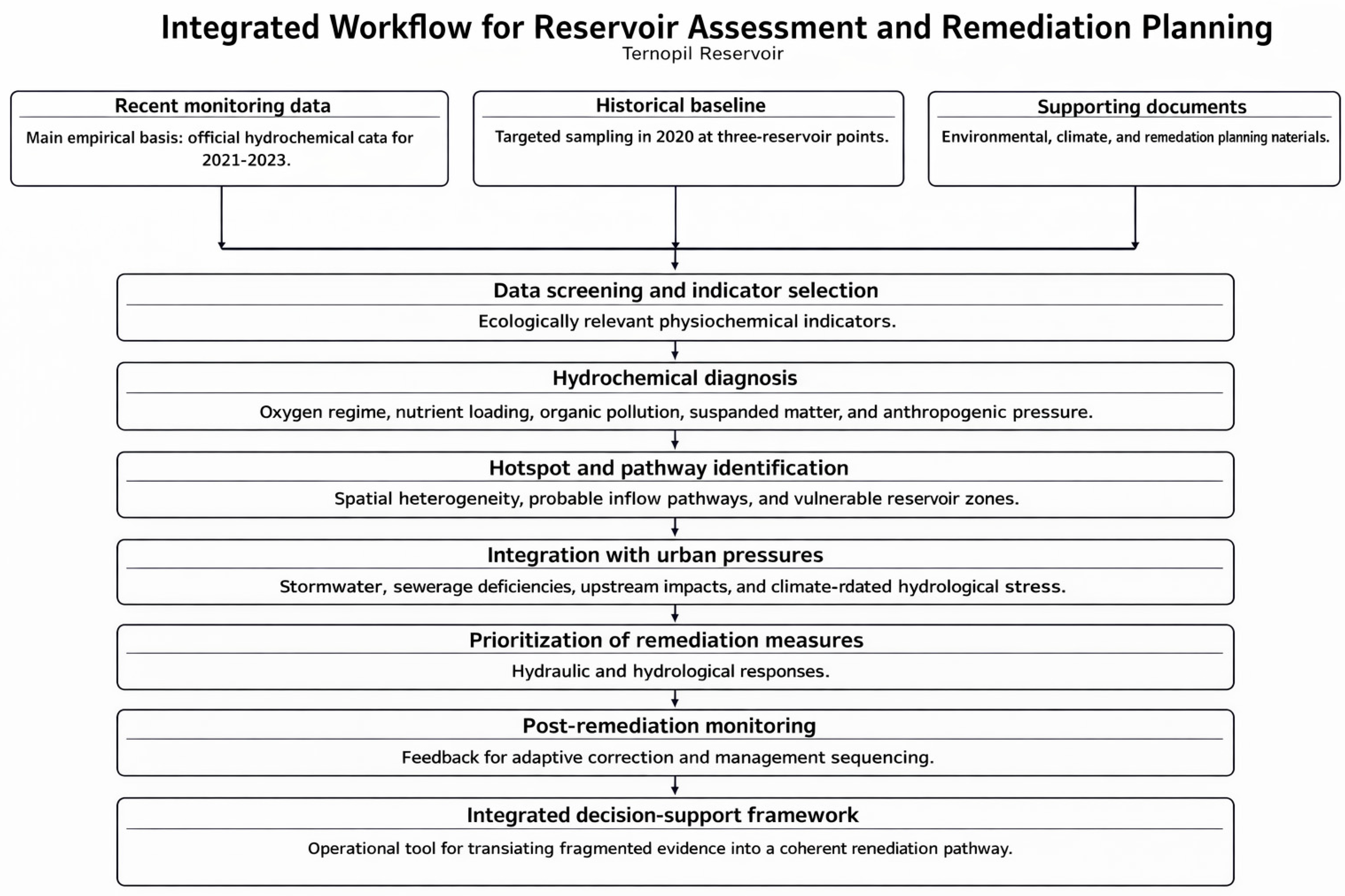
Particular attention was paid to remediation-oriented materials proposing a staged logic of reservoir management that includes: (1) monitoring and environmental assessment; (2) hydraulic and engineering measures; (3) hydrobiological measures; and (4) post-monitoring with corrective adjustment [30]. This logic was adopted as the conceptual basis for structuring the decision-support framework developed in the present study and for linking environmental diagnosis with intervention planning. Additional municipal programme materials were used to verify the practical relevance of proposed interventions, including aeration, drainage improvement, ecological treatment measures, and stormwater infrastructure development in areas adjacent to the reservoir [31].

2.5. Analytical Strategy and Framework Development

The analytical strategy combined comparative hydrochemical assessment with problem-oriented synthesis of environmental and planning information [32]. In the first stage, recent monitoring data were used to identify the dominant manifestations of hydrochemical deterioration and the most informative indicators of ecological stress. In the second stage, historical targeted sampling was used to verify whether within-reservoir deterioration was spatially uniform or concentrated in localised zones [33]. In the third stage, hydrochemical evidence was interpreted together with environmental and planning materials in order to connect observed water-quality symptoms with probable pressure pathways and infrastructural drivers. In addition, the comparative local survey conducted in April 2024 was used to situate the Ternopil Reservoir within the wider system of reservoirs of the Ternopil urban territorial community and to verify whether it remained the most environmentally stressed reservoir within the local reservoir system [34].
Comparative assessment was performed against the applicable regulatory benchmarks used in Ukrainian water-quality assessment practice, including environmental quality standards and permissible concentrations for surface waters [35]. This approach made it possible to identify the hydrochemical parameters most relevant to eutrophication, organic pollution, nutrient-related pressure, suspended matter accumulation, and anthropogenic inflow, and to interpret them not only descriptively, but also in relation to practical reservoir management needs [36]. Because the official hydrochemical dataset was available in aggregated annual form, including minimum, maximum, and mean values for 2021–2023, the analysis was based primarily on comparative interpretation rather than on inferential statistical testing. Accordingly, analytical depth was strengthened through interannual comparison, benchmark-oriented assessment, and hotspot-oriented synthesis linking hydrochemical patterns with probable pressure pathways and remediation relevance. The empirical design was structured for applied comparative diagnosis rather than for long-term forecasting. Within this design, the 2021–2023 monitoring series was used to identify recent hydrochemical instability and recurrent pressure patterns, while the 2020 targeted sampling layer was used to resolve spatially differentiated hotspot behaviour relevant to remediation planning. In this sense, the analytical emphasis was placed on comparative interpretation, pressure-pathway reconstruction, and hotspot-oriented decision support within an applied municipal reservoir context. The analytical strategy was not designed as a predictive or optimisation-based modelling exercise. Because the available hydrochemical dataset consisted of aggregated annual monitoring statistics rather than continuous raw observations, the study did not aim to perform scenario simulation, numerical optimisation, correlation analysis, or inferential statistical testing. Instead, the quantitative component of the analysis was based on interannual comparison of annual mean values, relative-change interpretation, and benchmark-oriented assessment of the most informative hydrochemical indicators. In this sense, the proposed framework should be understood as an applied decision-support structure for evidence integration and remediation prioritisation rather than as a predictive decision model.
The decision-support framework was developed through the integration of monitoring evidence, hotspot-oriented baseline interpretation, and local remediation logic. Its structure was organised into four consecutive stages: (1) diagnosis of ecological condition; (2) identification of vulnerable zones and major pressure pathways; (3) selection of feasible hydraulic and hydrobiological remediation measures; and (4) post-remediation monitoring for adaptive correction. In methodological terms, the framework was designed as an operational tool for translating fragmented local evidence into a coherent remediation pathway for an urban reservoir exposed to multiple environmental stressors, including the broader need for adaptive response under systemic and war-related environmental pressure [37,38]. Methodologically, the framework differs from more general decision-support structures not by proposing a wholly new universal sequence of management stages, but by specifying how three heterogeneous evidence layers—official hydrochemical monitoring data, historical hotspot-oriented sampling, and local environmental and planning materials—can be combined within a single applied municipal workflow. In this sense, the framework represents an operational methodological adaptation for data-limited urban reservoirs, where fragmented evidence exists but is not yet organised into a coherent remediation-planning structure. The integrated workflow adopted for the hydrochemical assessment of the Ternopil Reservoir and the subsequent development of the decision-support framework is presented in Figure 2.

3. Results

3.1. Current Hydrochemical Condition of the Ternopil Reservoir

Available local evidence indicates that the Ternopil Reservoir currently represents the most environmentally stressed reservoir within the Ternopil urban territorial community [7,8]. This status is associated with substantial anthropogenic loading from the urban environment, as well as the cumulative influence of inflow from upstream sections of the Seret River, into which multiple discharges are conveyed before reaching the reservoir. In basin-connected urban water systems, such pressure pathways should be interpreted not only as hydrochemical problems, but also as water-governance challenges, because effective remediation depends on coordination between municipal authorities, basin-management institutions, and other stakeholders [39]. At the same time, the reservoir functions as the ecological core of a broader urban hydroecosystem, and its water quality is shaped by the interaction of catchment-scale runoff formation, pollutant inputs, and internal processes governed by water exchange, temperature, and oxygen regime. Selected hydrochemical indicators of the Ternopil Reservoir based on official monitoring data for 2021–2023 are presented in Table 1.
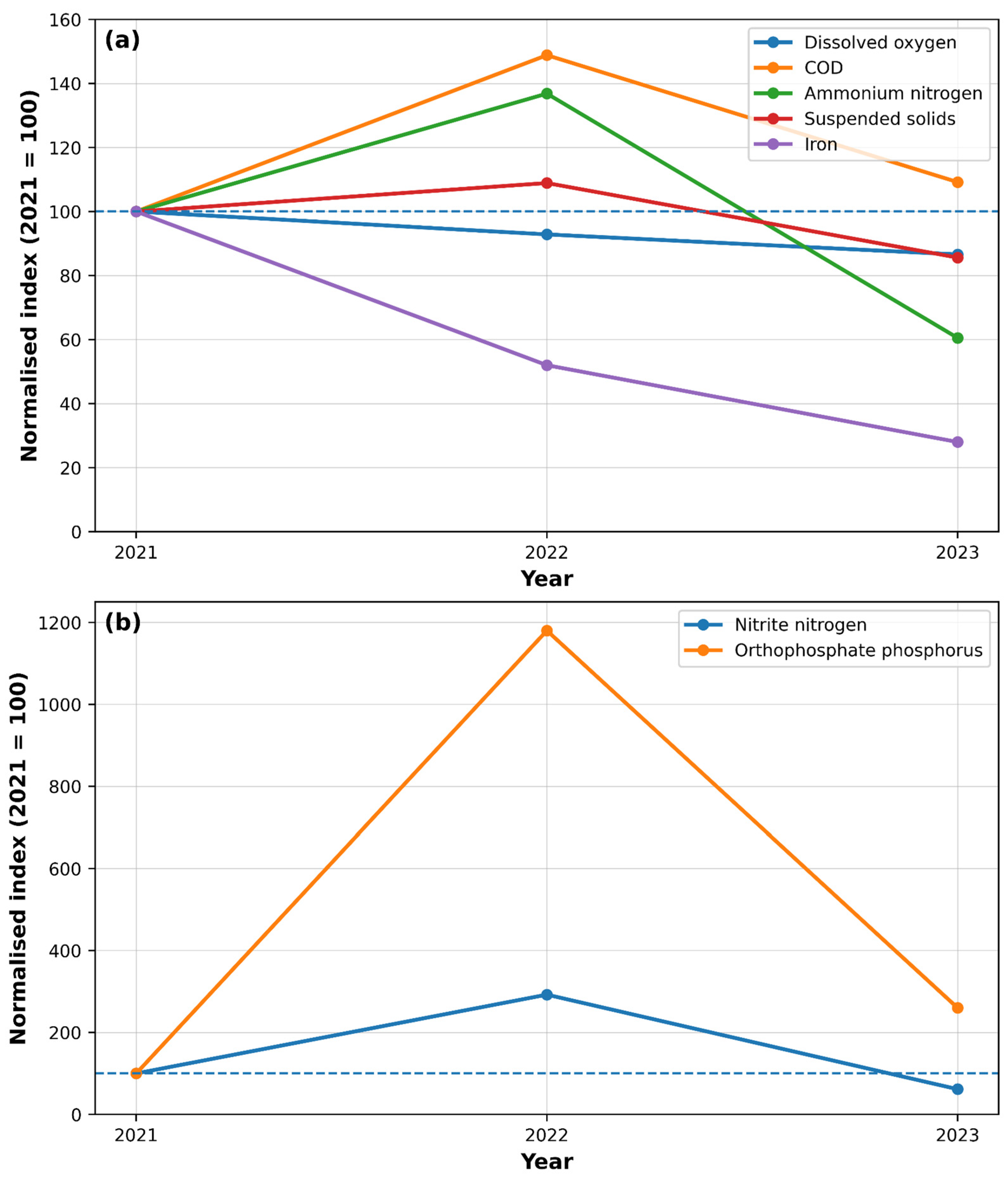
The 2021–2023 monitoring data indicate that the hydrochemical condition of the Ternopil Reservoir was characterised by persistent nutrient-related and organic pressure, with the most pronounced hydrochemical tension observed in 2022. In particular, 2022 showed the highest mean values for COD (25.9 mg O2/L), ammonium nitrogen (0.52 mg/L), nitrite nitrogen (0.038 mg/L), orthophosphate phosphorus (0.059 mg/L), and suspended solids (15.9 mg/L), while dissolved oxygen declined from 11.2 mg O2/L in 2021 to 9.7 mg O2/L in 2023. At the same time, mean iron concentrations decreased from 0.25 mg/L in 2021 to 0.07 mg/L in 2023, whereas BOD5 remained relatively stable over the study period. Taken together, these patterns suggest that the reservoir remained hydrochemically sensitive throughout 2021–2023, with fluctuations reflecting varying intensity of nutrient enrichment, organic load, and suspended matter input [41].
A more detailed interannual interpretation indicates that 2022 represented the year of maximum hydrochemical tension within the analysed period. Relative to 2021, mean COD increased by approximately 48.9%, ammonium nitrogen by 36.8%, nitrite nitrogen by 192.3%, orthophosphate phosphorus by more than tenfold, and suspended solids by 8.9%, while dissolved oxygen in 2023 was 13.4% lower than in 2021. Although several nutrient-related indicators declined again in 2023, this pattern does not indicate full recovery of the system. Rather, it suggests recurrent hydrochemical instability, with 2022 marking the strongest expression of nutrient-related and organic pressure. From a hydroecological perspective, this pattern is consistent with the interaction of external nutrient and organic loading, suspended-matter inflow, and internal hydrodynamic constraints within the reservoir. Elevated COD, ammonium nitrogen, nitrite nitrogen, orthophosphate phosphorus, and suspended solids in 2022 indicate intensified pollutant delivery and eutrophication-related pressure, while the subsequent decline in dissolved oxygen is consistent with increased oxygen consumption during organic matter decomposition and periods of reduced water exchange. In such urban reservoir settings, these processes are typically reinforced by warm-season stratification tendencies, runoff-related inflow, and local stagnation in hydraulically weak sectors, which together increase the likelihood of recurrent ecological destabilisation rather than uniform year-to-year deterioration [8,20,23,24].
Figure 3 presents the normalised interannual dynamics of selected representative hydrochemical indicators from Table 1. To preserve readability, the figure is divided into two panels: Figure 3a shows indicators with moderate interannual variation, whereas Figure 3b shows high-variability nutrient indicators whose sharp increase in 2022 would distort the scale if all parameters were plotted together.
A spring 2024 hydrochemical survey of the reservoirs within the Ternopil urban territorial community showed that, for the selected physicochemical parameters, no formal exceedances of the reported maximum permissible concentrations were identified [42]. However, the Ternopil Reservoir displayed the highest total water hardness among the compared reservoirs and one of the highest phosphate concentrations. The recorded values for the Ternopil Reservoir in April 2024 were as follows: pH 7.7, a total hardness value of 5.3 meq/L, ammonium nitrogen 0.86 mg/L, phosphates 0.07 mg/L, chlorides 16.3 mg/L, and nitrates 7.2 mg/L. In this sense, the hydrochemical picture of the reservoir in the spring period may be described as relatively moderate in terms of the selected compliance-based indicators, but still environmentally sensitive when interpreted in relation to nutrient-related pressure and the broader degradation pattern observed in this water body [43]. Accordingly, the spring 2024 survey should be interpreted as a compliance-oriented seasonal snapshot rather than a complete representation of the reservoir’s annual hydrochemical behaviour, which becomes markedly more unstable during the warm period [44].
At the same time, official environmental materials emphasise that the hydrochemical condition of the reservoir cannot be assessed solely through a single seasonal snapshot [45]. Over the last several years, the reservoir has repeatedly exhibited summer episodes of water blooming, intensive development of planktonic algae, and unpleasant odour. These symptoms are linked to increasing water temperature and the input of organic matter and nitrogen- and phosphorus-containing compounds. The documents further note that ecological problems become most acute during the warm season, when cyanobacterial development intensifies and the reservoir becomes more vulnerable to hydrochemical and hydrobiological destabilisation [46]. The practical relevance of targeted remediation is also supported by site-specific technical solutions, including a patented method for removing the bottom layer of water from a reservoir, which is particularly relevant for zones affected by stagnation and oxygen-regime instability [47]. Historical targeted sampling within the reservoir additionally showed that hydrochemical deterioration was spatially heterogeneous rather than uniform. Sampling performed on 6 July 2020 at three within-reservoir points revealed localised exceedances of selected indicators: elevated BOD5 and nitrite ions were identified near the Halychyna Hotel, while the site near the Naddstavna Church showed exceedances for ammonium nitrogen, BOD5, petroleum products, suspended solids, and total iron [48]. These results indicate the presence of localised hydroecological hotspots associated with restricted water exchange and probable pollutant inflow from urbanised sections of the waterfront. Taken together, the available evidence suggests that the current hydrochemical condition of the Ternopil Reservoir is best characterised not by uniform deterioration across the entire water body, but by the interaction of persistent eutrophication-related vulnerability, seasonal ecological instability, and spatially differentiated anthropogenic pressure [49].

3.2. Spatial Heterogeneity and Historical Hotspot Evidence

Historical targeted sampling within the Ternopil Reservoir provided spatially explicit evidence that hydrochemical deterioration in the water body is not uniformly distributed, but concentrated in localised zones of elevated environmental pressure [50]. The sampling design was intended to capture within-reservoir heterogeneity by covering sites associated with different hydrological and anthropogenic settings, including waterfront urbanised areas and zones influenced by concentrated inflow pathways. In this way, the historical dataset was used to identify hydrochemical hotspots rather than to provide a full spatial characterisation of the entire reservoir [51].
The results revealed a clear pattern of spatial differentiation. Localised exceedances of BOD5 and nitrite ions were recorded near the Halychyna Hotel, indicating organic loading and hydrochemical instability in that part of the reservoir. The most pronounced hotspot was identified near the Naddstavna Church, where exceedances were observed for ammonium nitrogen, BOD5, petroleum products, suspended solids, and total iron [52]. This location therefore concentrated the strongest combination of nutrient-related, organic, and anthropogenic hydrochemical pressure among the surveyed zones. By contrast, the inflow-related sampling site near the stormwater collector was not identified in the official summary as the principal hotspot for exceedances, which further supports the conclusion that deterioration within the reservoir is spatially differentiated rather than evenly distributed [53].
This pattern is hydroecologically consistent with the internal functioning of the reservoir. Remediation-oriented local materials indicate that the area near the Naddstavna Church is characterised by weak water circulation and limited exchange with the main flow path of the reservoir, creating conditions favourable for stagnation, oxygen depletion, accumulation of organic matter, and intensified eutrophication processes. The same zone has been described as especially prone to seasonal blooming and associated water-quality deterioration, which reinforces its interpretation as a persistent hydroecological hotspot rather than a temporally isolated anomaly [54].
Taken together, the historical hotspot evidence confirms that the hydrochemical degradation of the Ternopil Reservoir should be interpreted as spatially differentiated. The reservoir does not function as a chemically uniform water body; instead, it contains localised zones of elevated ecological stress linked to waterfront urbanisation, inflow concentration, and restricted internal water exchange. This finding is important for remediation planning because it supports a targeted rather than spatially uniform management approach and justifies the prioritisation of hotspot-oriented hydraulic and hydrobiological interventions [55].

3.3. Infrastructure-, Runoff-, and Catchment-Related Pressure Pathways

The hydrochemical degradation of the Ternopil Reservoir cannot be explained solely by in-reservoir processes, since the water body is exposed to multiple external pressure pathways operating at both the catchment and urban scales. Within the Ternopil urban territorial community, the Seret River is described as being in an unsatisfactory ecological condition, affected by household waste accumulation and by exceedances of selected water-quality indicators, including suspended solids, BOD5, nitrates, petroleum products, sulfates, and chlorides [56]. Because the reservoir receives inflow from upstream sections of the Seret River, this already compromised riverine input should be regarded as a major external pathway of hydrochemical stress affecting reservoir water quality [57]. The main pressure pathways affecting the Ternopil Reservoir, together with their hydroecological implications and management relevance, are summarised in Table 2.
A second major pathway is related to urban runoff and deficiencies in stormwater and sewerage infrastructure. Municipal environmental programme materials indicate the absence of effective systems for collecting and treating stormwater and snowmelt runoff across a substantial part of the city, as well as incomplete sewerage coverage in some urban districts [58]. The same materials also note the existence of users connected to centralised water supply but not to wastewater disposal, together with households not connected to either centralised water supply or centralised sewerage. Taken together, these conditions increase the likelihood that pollutant loads reach the reservoir through diffuse urban runoff, insufficiently controlled discharges, and hydraulic overload of the existing urban water infrastructure [59].
The pressure on the reservoir is further intensified by the disturbance of water-protection zones and by shoreline urbanisation. Strategic environmental assessment materials state that development within the water-protection zone of the Ternopil Reservoir has become a routine phenomenon, including buildings effectively located at the water’s edge and construction along the shoreline in the Kutkivtsi area. These processes are described as disturbing the water balance of the Seret River and hindering its natural recovery. The same assessment characterises the basin as anthropogenically transformed, with an anthropogenic load coefficient of 0.13. Under such conditions, shoreline urbanisation should be interpreted not only as a land-use issue, but also as a direct pressure pathway affecting runoff composition, bank stability, and the ecological self-recovery capacity of the reservoir system [60].
The hydrological functioning of the reservoir system also supports the interpretation of multiple interacting pressure pathways. Remediation-oriented materials describe the Ternopil Reservoir as the ecological core of a broader hydroecosystem extending along the Seret River corridor and connected with adjacent water bodies and urbanised territories. This means that pollutant inputs, runoff redistribution, and local hydrochemical responses should be interpreted within a larger hydrological setting rather than as isolated processes limited to the impounded water body itself. Such a system-level perspective is important for understanding why hydrochemical deterioration persists despite the absence of uniformly severe exceedances in every monitoring period [61].
Taken together, these findings indicate that the Ternopil Reservoir functions as a receiving node of several interacting pressure pathways, including upstream riverine inflow, diffuse urban runoff, sewerage deficiencies, shoreline transformation, and broader anthropogenic alteration of the catchment. Their combined influence helps explain why degradation persists even when hydrochemical exceedances are not uniformly severe across all monitoring periods. This, in turn, indicates that the reservoir’s deterioration cannot be addressed through isolated corrective actions and instead requires integrated remediation planning that combines hydraulic, infrastructural, and hydrobiological measures [62].

3.4. Decision-Support Implications for Remediation Planning

The results of the present study indicate that remediation planning for the Ternopil Reservoir should not be based on uniform corrective action across the entire water body, but on a spatially and functionally differentiated strategy. In the broader Ukrainian sustainability context, environmental decision-making for infrastructure-related systems increasingly requires evidence-based assessment tools capable of linking technical measures with environmental performance and long-term resilience [63]. The combination of recent hydrochemical monitoring, historical hotspot evidence, and analysis of pressure pathways shows that the reservoir is affected by interacting processes of nutrient enrichment, organic loading, suspended-matter input, and hydrodynamic weakness [8,20,23,24,62]. Accordingly, the most appropriate remediation logic is not a single-measure response, but a staged framework that links diagnosis of ecological condition with the identification of vulnerable zones, targeted intervention selection, and post-remediation control. This interpretation is directly consistent with the local remediation model, which structures intervention planning through monitoring and assessment, hydraulic measures, hydrobiological measures, and post-monitoring with corrective adjustment [64].
A first practical implication of the results is the need to prioritise hotspot-oriented hydraulic interventions in hydraulically weak and environmentally sensitive parts of the reservoir [65]. The historical hotspot pattern identified near the Naddstavna Church, together with the broader interpretation of restricted circulation and seasonal instability, indicates that measures aimed at improving water exchange and oxygen conditions are likely to have the highest immediate remediation relevance. In this sense, the decision-support framework developed in the present study favours targeted technical responses adapted to hydrodynamically vulnerable zones rather than spatially uniform intervention across the entire reservoir [66].
A short illustrative application of the framework may be considered for the historically identified hotspot near the Naddstavna Church. In practical terms, this zone may first be prioritised through monitoring-based diagnosis because of its combined exceedances of ammonium nitrogen, BOD5, petroleum products, suspended solids, and total iron, together with its weak circulation regime. The next step would involve linking these symptoms to probable local pressure pathways, including restricted water exchange and runoff-related pollutant inflow. On this basis, the most appropriate response would include targeted hydraulic intervention, local circulation or aeration improvement, complementary hydrobiological measures, and subsequent follow-up monitoring in order to assess whether hotspot intensity declines after implementation. This example demonstrates how the proposed framework can support the transition from hydrochemical diagnosis to sequenced remediation planning in practice.
A second implication is that hydraulic and engineering measures should be complemented by hydrobiological and catchment-oriented actions rather than implemented in isolation. This combined approach is also relevant for Ukraine because wartime conditions have demonstrated the vulnerability of rivers, reservoirs, and water infrastructure to systemic disruption and environmental damage [67]. The local remediation materials explicitly frame reservoir recovery as a combined process in which technical interventions are accompanied by ecological measures and subsequent monitoring [30,31,64]. At the same time, municipal environmental materials indicate that stormwater and snowmelt runoff, incomplete sewerage coverage, and deficient wastewater connectivity remain important pressure pathways. This means that any remediation strategy limited to in-reservoir treatment alone would address symptoms without sufficiently reducing the inflow of pollutants from the wider urban system. From a decision-support perspective, the results therefore justify a dual-track strategy: hotspot-oriented in-reservoir intervention combined with measures that reduce pollutant delivery from the catchment and urban drainage network [68].
A third implication concerns the role of adaptive implementation. The hydrochemical patterns documented in this study, especially the contrast between relatively moderate compliance-oriented spring conditions and recurrent warm-season instability, suggest that remediation should be treated as an iterative rather than one-off process [69]. In practice, this means that intervention sequencing should include follow-up monitoring, reassessment of hotspot behaviour, and adjustment of control measures according to observed system response. Thus, the principal decision-support implication of the present study is that remediation planning for the Ternopil Reservoir should be structured as a monitored, phased, and hotspot-sensitive process integrating hydraulic, hydrobiological, and urban-infrastructural responses rather than relying on single isolated interventions [70].

4. Discussion

The present study demonstrates that the hydroecological deterioration of the Ternopil Reservoir is best understood not as the result of a single dominant pollutant source, but as the outcome of multiple interacting pressures operating across temporal and spatial scales [71]. The analysis of official monitoring data for 2021–2023 showed persistent nutrient-related and organic pressure, with the strongest hydrochemical tension observed in 2022. This was reflected in the simultaneous increase in COD, ammonium nitrogen, nitrite nitrogen, orthophosphate phosphorus, and suspended solids, while dissolved oxygen showed a declining tendency from 2021 to 2023. The spring 2024 comparative survey, by contrast, indicated relatively moderate compliance-oriented conditions for the selected parameters. This contrast suggests that a single seasonal assessment may underestimate the broader instability of the reservoir system. Historical targeted sampling further showed that hydrochemical stress is spatially differentiated and concentrated in localised hotspot zones, especially near the Naddstavna Church. Taken together, these findings indicate that the reservoir is affected by recurrent eutrophication-related vulnerability, hotspot-specific hydrochemical loading, and broader urban- and catchment-derived pressures [72].
This interpretation is consistent with the rehabilitation perspective proposed by Hughes et al. [1], who emphasised that urban water-body restoration requires attention not only to water quality, but also to the pressures generated by surrounding urban systems. The Ternopil case supports this view because the observed deterioration cannot be explained by one parameter alone. Instead, the 2022 hydrochemical pattern combines organic pressure, nutrient-related enrichment, suspended-matter input, and oxygen-regime vulnerability. The present study extends this rehabilitation-oriented logic by translating the diagnosis of an urban reservoir into a staged remediation framework adapted to a Ukrainian municipal context.
The results also correspond to the multi-pressure interpretation of urban waters developed by Teurlincx et al. [5]. Their work highlights that restoration of urban water bodies depends on identifying the main interacting pressures rather than treating visible symptoms in isolation. In the Ternopil Reservoir, this multi-pressure mechanism is visible in both the monitoring data and the spatial evidence: nutrient-related indicators peaked in 2022, while historical sampling identified localised hotspots associated with weak circulation and probable pollutant accumulation. This combination shows that remediation should not be designed as a uniform intervention across the whole reservoir, but as a spatially differentiated response that addresses both external inflow pathways and internal hydrodynamic constraints.
The nutrient-related component of the results is especially relevant in relation to previous studies on eutrophication. Bhagowati and Ahamad [20] described lake eutrophication as a dynamic process involving nutrient enrichment, algal development, oxygen-regime disturbance, and internal feedbacks. The Ternopil data reflect several elements of this mechanism. Orthophosphate phosphorus increased from 0.005 mg/L in 2021 to 0.059 mg/L in 2022, while nitrite nitrogen increased from 0.013 mg/L to 0.038 mg/L over the same period. These changes coincided with higher COD and suspended solids, suggesting that nutrient-related pressure was accompanied by organic and particulate inputs rather than occurring as an isolated chemical signal. The subsequent decline in dissolved oxygen further supports the interpretation that the reservoir remained vulnerable to oxygen-regime instability.
The indicator-based logic of the study is also consistent with Suresh et al. [23], who emphasised the importance of water-quality indicators for identifying eutrophication processes in freshwater lakes. In the present study, dissolved oxygen, COD, ammonium nitrogen, nitrite nitrogen, nitrate nitrogen, orthophosphate phosphorus, suspended solids, and BOD5 were used not as a general list of available variables, but as indicators of specific hydroecological pressure pathways. This is important because the strongest evidence of deterioration lies not in a single exceedance, but in the combined behaviour of oxygen-regime, organic-load, nutrient, and suspended-matter indicators. The revised two-panel Figure 3 strengthens this interpretation by separating moderately variable indicators from high-variability nutrient indicators, thereby making the nutrient-related peak in 2022 more visible without distorting the graphical scale.
The local relevance of these findings becomes clearer when compared with previous regional studies. Hrubinko et al. [9] assessed the hydroecological situation of the Verkhno-Ivachivsk Reservoir in the Ternopil region, while Humeniuk et al. [17,73] examined chemical pollution of small rivers using modelling approaches. Grubinko et al. [32] also analysed the ecotoxicological status and prognosis of an urbanised hydroecosystem using the example of the Ternopil pond. These studies confirm that hydroecological degradation of reservoirs and small river systems in the region has already been recognised as a scientific and management issue. The present study differs from these earlier works by focusing less on diagnosis alone and more on the transition from diagnosis to remediation planning. Its added value lies in connecting recent official monitoring data, historical hotspot-oriented sampling, and municipal environmental-planning evidence within a single decision-support workflow.
A key implication of the results is that the Ternopil Reservoir cannot be adequately interpreted through routine compliance assessment alone. The contrast between relatively moderate spring 2024 values and documented warm-season problems, including water blooming, unpleasant odour, and hotspot-related exceedances, suggests that hydroecological risk in urban reservoirs is strongly season-dependent and hydrodynamically mediated. This interpretation is consistent with studies showing that urban lake assessment benefits from multi-source data and modelling approaches [74,75], and with research emphasising the role of stormwater pathways and green-infrastructure responses in urban water-quality management [76]. For Ternopil, the protected-area and nature-conservation context of the urban territorial community also reinforces the need to treat the reservoir as part of a wider urban ecological network rather than as an isolated water body [77].
The hotspot evidence has direct implications for remediation planning. The area near the Naddstavna Church was identified as the most pronounced historical hotspot, with exceedances involving ammonium nitrogen, BOD5, petroleum products, suspended solids, and total iron. This spatial pattern indicates that internal reservoir functioning is not uniform. Zones with weak circulation and limited exchange with the main flow path are more likely to accumulate pollutants, experience oxygen depletion, and intensify eutrophication-related processes. Therefore, remediation should prioritise hydrodynamically vulnerable sectors through targeted measures such as circulation improvement, aeration, local removal of stagnant bottom-water layers, and follow-up hydrochemical control. Research on an urban artificial lake has shown that hydrodynamic interventions, including water diversion, can influence water-quality dynamics [65], while European water-resilience assessments emphasise the need to connect ecological restoration with water-system resilience [66,78]. In the Ternopil case, site-specific technical options, including the patented method for removing bottom-layer water from a reservoir, show that such hotspot-oriented interventions are not purely theoretical [47,79].
At the same time, in-reservoir intervention alone would not be sufficient. The pressure-pathway analysis indicates that reservoir degradation is also linked to upstream inflow from the Seret River, diffuse urban runoff, incomplete sewerage coverage, stormwater-system deficiencies, shoreline urbanisation, and disturbance of water-protection zones. This interpretation is consistent with broader research on the effects of urbanisation on hydrological and water-quality dynamics, as well as with recent European policy emphasis on urban wastewater treatment and pollution reduction [80,81]. Accordingly, remediation should combine hotspot-oriented measures within the reservoir with catchment- and infrastructure-oriented actions aimed at reducing pollutant delivery to the water body.
The decision-support contribution of this study should be understood in this practical context. De Kok and Wind [13] framed decision-support systems as tools for integrated water management, while Goharian and Burian [14] developed an integrated framework for decision support in urban water management. Candido et al. [21] further showed that DSS approaches in integrated water resources management increasingly aim to connect water-quality evidence with management priorities. The present study follows this general DSS logic, but adapts it to a data-limited municipal reservoir context. Unlike modelling-based DSS approaches that require high-frequency observations or complex optimisation procedures, the proposed framework uses the evidence that is realistically available to local authorities: annual hydrochemical monitoring data, targeted hotspot information, and municipal planning documents.
This operational adaptation is also relevant to river-basin governance. Ukrainian methodological recommendations for establishing environmental objectives, developing programmes of measures, and performing cost-effectiveness analysis for river basin management plans emphasise the need to connect environmental diagnosis with practical measures [71]. Similar integrated water resources management perspectives have also been discussed in the wider Central and Eastern European context [72]. The proposed framework is consistent with these principles because it links diagnosis, vulnerable-zone identification, remediation selection, and post-remediation monitoring within one sequence. Its contribution is that it applies this logic at the scale of a specific urban reservoir, where fragmented evidence must be converted into actionable municipal decisions.
The Ukrainian context further increases the practical relevance of such an approach. Recent studies have documented the vulnerability of Ukrainian water bodies and water infrastructure under wartime conditions [67,74], and broader analyses have shown that the war has generated significant environmental and human-health consequences [77]. War-related human activities have also been shown to affect freshwater ecosystems, including biological components such as microalgae and macrophytes [79]. The present study does not assess direct war damage to the Ternopil Reservoir. However, it contributes to the broader need for environmental governance tools that remain usable under systemic pressure, limited resources, infrastructure stress, and uncertainty. This practical relevance is also consistent with wider assessments of Ukraine’s institutional and economic challenges during reconstruction and recovery [78].
The broader significance of the study lies in its transferability to other urban reservoirs exposed to combined nutrient loading, runoff-related pollution, infrastructural deficits, and climate-related hydrological instability. Many municipalities possess fragmented evidence of degradation, but lack an operational structure for converting that evidence into action priorities. The proposed framework is valuable because it does not depend on highly specialised modelling inputs; instead, it integrates official monitoring data, spatially explicit hotspot information, and locally available planning materials into a staged management logic. In this sense, the present study contributes not only a characterisation of the Ternopil Reservoir, but also an operational methodological adaptation of a monitoring-to-remediation workflow for urban reservoirs under complex and resource-constrained conditions.
The findings should nevertheless be interpreted in light of several methodological limitations. The official hydrochemical dataset consisted of annual minimum, maximum, and mean values rather than high-frequency raw observations. The historical three-point sampling design was intended for hotspot identification rather than exhaustive spatial representation of the entire reservoir. For these reasons, the study does not provide predictive modelling, scenario simulation, numerical optimisation, or formal statistical attribution of individual pressure sources. These limitations do not invalidate the practical value of the framework, but they define its appropriate use. The findings are strongest as an applied diagnostic and planning basis for identifying pressure patterns, recognising hotspot zones, and structuring remediation priorities. Future research should strengthen this framework through seasonal monitoring, higher-frequency oxygen and nutrient measurements, hydrodynamic assessment, and post-intervention monitoring after remediation measures are implemented.
Overall, the study extends previous research in three ways. First, it confirms, using local monitoring data, that urban reservoir degradation is driven by interacting pressures rather than by a single water-quality parameter. Second, it links eutrophication-related indicators with spatial hotspot evidence and urban infrastructure pressures in a specific Ukrainian municipal context. Third, it converts this evidence into an operational monitoring-to-remediation framework that can support staged reservoir management under data-limited and resource-constrained conditions.

5. Conclusions

This study showed that the Ternopil Reservoir should be interpreted as a multi-stressor urban hydroecosystem whose degradation is driven by the interaction of eutrophication-related processes, hotspot-specific hydrochemical pressure, infrastructural deficits, and catchment-derived pollutant inflow. Official monitoring data for 2021–2023 demonstrated persistent nutrient-related and organic pressure, with the strongest hydrochemical tension observed in 2022, while the spring 2024 survey confirmed that the reservoir remained environmentally sensitive even in the absence of formal exceedances for the selected compliance-based indicators. Historical targeted sampling further demonstrated that deterioration within the reservoir is spatially differentiated, with the most pronounced hotspot identified near the Naddstavna Church.
A second conclusion is that the hydrochemical condition of the reservoir cannot be explained by in-reservoir processes alone. The study identified several interacting pressure pathways, including compromised upstream inflow from the Seret River, diffuse urban runoff, incomplete sewerage coverage, disturbance of water-protection zones, shoreline urbanisation, and hydrodynamic weakness in poorly circulated parts of the reservoir. These findings explain why the ecological condition of the water body remains unstable and why remediation planning must combine hotspot-oriented in-reservoir measures with broader catchment and urban-infrastructural action.
The principal contribution of the study is the development of an integrated decision-support framework that links monitoring-based diagnosis, identification of vulnerable zones, prioritisation of hydraulic and hydrobiological interventions, and post-remediation adaptive control. The practical value of this framework lies in its ability to translate fragmented local evidence into a coherent remediation pathway for an urban reservoir under multiple environmental stressors. In a broader methodological sense, the proposed approach is consistent with current international directions in urban water management, where decision-support increasingly depends on combining hydrochemical evidence, spatially differentiated pressure interpretation, and intervention-oriented planning within a single operational workflow. Beyond the Ternopil case, the proposed approach may therefore be relevant for other urban reservoirs facing combined nutrient loading, runoff-related pollution, infrastructural deterioration, and broader systemic pressure, particularly in contexts where management decisions must be made with limited resources and high uncertainty.

Author Contributions

Conceptualization, S.D., O.B., D.J., V.P. and S.L.; methodology, S.D. and L.B.; software, S.L. and S.D.; validation, O.B. and L.B.; formal analysis, S.L. and S.D.; investigation, O.B. and S.D.; resources, S.D. and O.B.; data curation, S.L. and L.B.; writing—original draft preparation, D.J., V.P., S.D. and L.B.; writing—review and editing, D.J., V.P., S.L. and S.D.; visualization, S.D. and L.B.; supervision, S.L., S.D. and O.B.; project administration, S.D. and L.B.; funding acquisition, S.L. All authors have read and agreed to the published version of the manuscript.

Funding

This research received no external funding.

Data Availability Statement

The data supporting the findings of this study are contained within the article. Additional source materials derived from official local monitoring, environmental assessment, and planning documents are available from the corresponding author upon reasonable request.

Acknowledgments

The authors gratefully acknowledge the Department of Ecology and Health Protection, Educational and Scientific Institute of Innovation, Environmental Management and Infrastructure, West Ukrainian National University, 11, Lvivska St., 46009 Ternopil, Ukraine, for institutional support provided during the preparation of this study.

Conflicts of Interest

The authors declare no conflicts of interest.

References

  1. Hughes, R.M.; Dunham, S.; Maas-Hebner, K.G.; Yeakley, J.A.; Schreck, C.B.; Harte, M.; Molina, N.; Shock, C.C.; Kaczynski, V.W.; Schaeffer, J. A review of urban water body challenges and approaches: (1) Rehabilitation and remediation. Fisheries 2014, 39, 18–29. [Google Scholar] [CrossRef]
  2. Reese, M. Transformation to healthy water ecology—Institutional requirements, deficits and options in European and German perspective. Sustainability 2021, 13, 3368. [Google Scholar] [CrossRef]
  3. Starke, J.R.; Van Rijswick, H.F.M.W. Exemptions of the EU Water Framework Directive deterioration ban: Comparing implementation approaches in Lower Saxony and The Netherlands. Sustainability 2021, 13, 930. [Google Scholar] [CrossRef]
  4. Zhao, X.; Huang, G. Urban watershed ecosystem health assessment and ecological management zoning based on landscape pattern and SWMM simulation: A case study of Yangmei River Basin. Environ. Impact Assess. Rev. 2022, 95, 106794. [Google Scholar] [CrossRef]
  5. Teurlincx, S.; Kuiper, J.J.; Hoevenaar, E.C.M.; Lurling, M.; Brederveld, R.J.; Veraart, A.J.; Janssen, A.B.G.; Mooij, W.M.; De Senerpont Domis, L.N. Towards restoring urban waters: Understanding the main pressures. Curr. Opin. Environ. Sustain. 2019, 36, 49–58. [Google Scholar] [CrossRef]
  6. Ternopil City Council. Programme “Drinking Water of the Ternopil Urban Territorial Community for 2025–2027”; Ternopil City Council: Ternopil, Ukraine, 2024. Available online: https://ternopilcity.gov.ua/app10/8-45-31-dodatok-131224.pdf (accessed on 3 March 2026).
  7. Ternopil City Council. Report on the Strategic Environmental Assessment of the Environmental Protection Programme of the Ternopil Urban Territorial Community for 2024–2027; Ternopil City Council: Ternopil, Ukraine, 2024. Available online: https://ternopilcity.gov.ua/app10/zvit-seo-programi-ohoroni-navkolishnogo--prirodnogo-seredovishcha--24-27-22_03_24.pdf (accessed on 20 March 2026).
  8. Müller, A.; Österlund, H.; Marsalek, J.; Viklander, M. The pollution conveyed by urban runoff: A review of sources. Sci. Total Environ. 2020, 709, 136125. [Google Scholar] [CrossRef]
  9. Hrubinko, V.V.; Humeniuk, H.B.; Humeniuk, V.V.; Andrusushyn, T.V.; Khomenchuk, V.O.; Harmatiy, N.M.; Chen, I.B. Assessment of the hydro-ecological situation of the Verkhno-Ivachivsk Reservoir in Ternopil using the fuzzy logic apparatus. J. Geol. Geogr. Geoecol. 2023, 32, 254–265. [Google Scholar] [CrossRef] [PubMed]
  10. Santos, E. Reforming water governance: Nordic lessons for Southern Europe. Sustainability 2025, 17, 7079. [Google Scholar] [CrossRef]
  11. Ternopil City Council. Programme of Environmental Protection of the Ternopil Urban Territorial Community for 2024–2027; Ternopil City Council: Ternopil, Ukraine, 2024. Available online: https://ternopilcity.gov.ua/app10/programa-onps-tmtg---zahodi-140624.pdf (accessed on 6 March 2026).
  12. Lousada, S.; Gómez, J.M.N.; Vilčekova, S.; Delehan, S. Integrating resilient water infrastructure and environmental impact assessment in borderland river basins. Water 2025, 17, 1205. [Google Scholar] [CrossRef]
  13. de Kok, J.-L.; Wind, H.G. Design and application of decision-support systems for integrated water management: Lessons to be learnt. Phys. Chem. Earth 2003, 28, 571–578. [Google Scholar] [CrossRef]
  14. Goharian, E.; Burian, S.J. Developing an integrated framework to build a decision support tool for urban water management. J. Hydroinform. 2018, 20, 708–727. [Google Scholar] [CrossRef]
  15. Delehan-Kokaiko, S.; Glyudzyk, E.; Symkanuch, O. Integrated assessment of atmospheric air pollution by the example of the city of Uzhhorod (Ukraine). Technol. Audit Prod. Reserv. 2021, 4, 27–31. [Google Scholar] [CrossRef]
  16. Ternopil City Council. Strategic Plan for the Development of the Ternopil Urban Territorial Community Until 2029; Ternopil City Council: Ternopil, Ukraine, 2019. Available online: https://ternopilcity.gov.ua/strategichni-ta-programni-dokumenti/plan-strategichnogo-rozvitku-mista-ternopolya-do-2025-roku/18938.html (accessed on 10 March 2026).
  17. Humeniuk, H.B.; Khomenchuk, V.O.; Harmatiy, N.M.; Chen, I.B. Complex assessment and forecasting of chemical pollution of small rivers by economic and mathematical modelling methods. J. Geol. Geogr. Geoecol. 2021, 30, 460–469. [Google Scholar] [CrossRef] [PubMed]
  18. Ternopil City Council. List of Sectoral Programmes of the Ternopil Urban Territorial Community in Force in 2026; Ternopil City Council: Ternopil, Ukraine, 2026. Available online: https://ternopilcity.gov.ua/strategichni-ta-programni-dokumenti/galuzevi-programi/perelik-galuzevih-program-ternopilskoi-miskoi-teritorialnoi-gromadi-chinnih-u-2026-rotsi/ (accessed on 12 March 2026).
  19. Department of Ecology and Natural Resources of Ternopil Regional Military Administration. Regional Report on the State of the Environment in Ternopil Oblast in 2024; Department of Ecology and Natural Resources of the Ternopil Regional Military Administration: Ternopil, Ukraine, 2025. Available online: https://ecology.te.gov.ua/media/uploads/%D1%80%D0%B5%D0%B3_%D0%B4%D0%BE%D0%BF%D0%BE%D0%B2%D1%96%D0%B4%D1%8C2024%D0%BE%D1%80%D0%B8%D0%B3%D1%96%D0%BD%D0%B0%D0%BB.pdf (accessed on 11 March 2026).
  20. Bhagowati, B.; Ahamad, K.U. A review on lake eutrophication dynamics and recent developments in lake modeling. Ecohydrol. Hydrobiol. 2019, 19, 155–166. [Google Scholar] [CrossRef]
  21. Candido, L.A.; Coêlho, G.A.G.; de Moraes, M.M.G.A.; Florêncio, L. Review of decision support systems and allocation models for integrated water resources management focusing on joint water quantity-quality. J. Water Resour. Plan. Manag. 2022, 148, 03121001. [Google Scholar] [CrossRef]
  22. Shumilova, O.; Tockner, K.; Sukhodolov, A.; Khilchevskyi, V.; de Meester, L.; Stepanenko, S.; Gleick, P. Impact of the Russia–Ukraine armed conflict on water resources and water infrastructure. Nat. Sustain. 2023, 6, 578–586. [Google Scholar] [CrossRef]
  23. Suresh, K.; Tang, T.; van Vliet, M.T.H.; Bierkens, M.F.P.; Strokal, M.; Sorger-Domenigg, F.; Wada, Y. Recent advancement in water quality indicators for eutrophication in global freshwater lakes. Environ. Res. Lett. 2023, 18, 063004. [Google Scholar] [CrossRef]
  24. Bhateria, R.; Jain, D. Water quality assessment of lake water: A review. Sustain. Water Resour. Manag. 2016, 2, 161–173. [Google Scholar] [CrossRef]
  25. ISO 5667-1:2023; Water Quality—Sampling—Part 1: Guidance on the Design of Sampling Programmes and Sampling Techniques. International Organization for Standardization: Geneva, Switzerland, 2023.
  26. ISO 5667-6:2014; Water Quality—Sampling—Part 6: Guidance on Sampling of Rivers and Streams. International Organization for Standardization: Geneva, Switzerland, 2014.
  27. ISO 5667-3:2024; Water Quality—Sampling—Part 3: Preservation and Handling of Water Samples. International Organization for Standardization: Geneva, Switzerland, 2024.
  28. Wang, Y.; Guo, Y.; Zhao, Y.; Wang, L.; Chen, Y.; Yang, L. Spatiotemporal heterogeneities and driving factors of water quality and trophic state of a typical urban shallow lake (Taihu, China). Environ. Sci. Pollut. Res. 2022, 29, 53831–53843. [Google Scholar] [CrossRef]
  29. Ternopil City Council. Amendments to the General Plan of the City of Ternopil. Explanatory Note; Ternopil City Council: Ternopil, Ukraine, 2022. Available online: https://ternopilcity.gov.ua/app10/ternopil-2022-vzgp.pdf (accessed on 20 March 2026).
  30. Ternopil City Council. Strategy for the Development of the Ternopil Urban Territorial Community; Ternopil City Council: Ternopil, Ukraine, 2025. Available online: https://ternopilcity.gov.ua/app11/%D0%A1%D1%82%D1%80%D0%B0%D1%82%D0%B5%D0%B3%D1%96%D1%8F%20%D0%A2%D0%B5%D1%80%D0%BD%D0%BE%D0%BF%D1%96%D0%BB%D1%8C%2005052025.pdf (accessed on 20 March 2026).
  31. Ternopil City Council. Comprehensive Programme for the Development of the Ternopil Reservoir “Ternopilskyi Stav” for 2017–2019; Ternopil City Council: Ternopil, Ukraine, 2016. Available online: https://ternopilcity.gov.ua/strategichni-ta-programni-dokumenti/galuzevi-programi/galuzevi-programi-arhiv/42513.html (accessed on 13 March 2026).
  32. Grubinko, V.V.; Humeniuk, H.B.; Khomenchuk, V.O.; Garmatiy, N.M.; Voytiuk, V.B.; Barna, M.M. Ecotoxicological status and prognosis of the state of an urbanized hydroecosystem (on the example of the reservoir “Ternopil pond”). J. Geol. Geogr. Geoecol. 2018, 27, 202–212. [Google Scholar] [CrossRef]
  33. Locke, K.A. Modelling relationships between land use and water quality using statistical methods: A critical and applied review. J. Environ. Manag. 2024, 362, 121290. [Google Scholar] [CrossRef]
  34. Su, S.; Ma, K.; Zhou, T.; Yao, Y.; Xin, H. Advancing methodologies for assessing the impact of land use changes on water quality: A comprehensive review and recommendations. Environ. Geochem. Health 2025, 47, 101. [Google Scholar] [CrossRef] [PubMed]
  35. European Parliament; Council of the European Union. Directive 2008/105/EC on environmental quality standards in the field of water policy. Off. J. Eur. Union 2008, L 348, 84–97. [Google Scholar]
  36. Tammeorg, O.; Nürnberg, G.; Horppila, J.; Haldna, M.; Niemistö, J.; Spears, B.M. Sustainable lake restoration: From challenges to solutions. WIREs Water 2024, 11, e1689. [Google Scholar] [CrossRef]
  37. van der Heijden, S.; Cassivi, A.; Mayer, A.; Sandholz, S. Water supply emergency preparedness and response in health care facilities: A systematic review on international evidence. Front. Public Health 2022, 10, 1035212. [Google Scholar] [CrossRef]
  38. Manzoni, A.; Hamam, M.; Pastorelli, G.; Servadei, L.; Chiappini, S.; Pesce, A.; Tarangioli, S.; Pergamo, R. The EU Nature Restoration Law (NRL) and the Common Agricultural Policy (CAP): State of the art and future challenges for Italian water resources. Land 2025, 14, 987. [Google Scholar] [CrossRef]
  39. Salamanca-Cano, A.K.; Durán-Díaz, P. Stakeholder engagement around water governance: 30 years of decision-making in the Bogotá River Basin. Urban Sci. 2023, 7, 81. [Google Scholar] [CrossRef]
  40. Regional Office of Water Resources in Ternopil Oblast. Official Hydrochemical Monitoring Data for the Ternopil Reservoir, 2021–2023; Regional Office of Water Resources in Ternopil Oblast: Ternopil, Ukraine, 2024. [Google Scholar]
  41. Bytsyura, L.; Szczepanik-Scislo, N.; Desyatnyuk, O.; Shakhovska, N.; Scislo, L.; Sachenko, A.; Lototska, O.; Shevchuk, I.; Sofinska, O. Research on surface water state for rivers in Western Ukraine using time series forecasting methods. Water 2025, 17, 3148. [Google Scholar] [CrossRef]
  42. Ternopil City Council. Report on the Strategic Environmental Assessment of the Programme of Economic and Social Development of the Ternopil Urban Territorial Community for 2025–2027; Ternopil City Council: Ternopil, Ukraine, 2024. Available online: https://ternopilcity.gov.ua/app10/seo-programi-ekonomichnogo-i-sotsialnogo-rozvitku-teropilskoi-mtg-06_12_2024.pdf (accessed on 20 March 2026).
  43. Ternopil City Council. Report on the Strategic Environmental Assessment of the Development Strategy of the Ternopil Urban Territorial Community; Ternopil City Council: Ternopil, Ukraine, 2025. Available online: https://ternopilcity.gov.ua/app10/zvit-pro-seo-strategii-rozvitku-ternopilskoi-mtg-100225.pdf (accessed on 20 March 2026).
  44. Mandryk, O.; Pukish, A.; Zelmanovych, A. Formation peculiarities of physical and chemical composition of highly mineralized edge water. Min. Miner. Depos. 2017, 11, 72–79. [Google Scholar] [CrossRef]
  45. Department of Ecology and Natural Resources of the Ternopil Regional Military Administration. Regional Report on the State of the Environment in Ternopil Oblast in 2022; Department of Ecology and Natural Resources of the Ternopil Regional Military Administration: Ternopil, Ukraine, 2023. Available online: https://ecology.te.gov.ua/media/uploads/%D1%80%D0%B5%D0%B3_%D0%B4%D0%BE%D0%BF%D0%BE%D0%B2%D1%96%D0%B4%D1%8C2022_%D0%BD%D0%BE%D0%B2%D0%B0.pdf (accessed on 20 March 2026).
  46. Zasidko, I.; Polutrenko, M.; Mandryk, O.; Stakhmych, Y.; Petroshchuk, N. Complex technology of sewage purification from heavy-metal ions by natural adsorbents and utilization of sewage sludge. J. Ecol. Eng. 2019, 20, 209–216. [Google Scholar] [CrossRef]
  47. Ukrainian National Office for Intellectual Property and Innovations. Utility Model Patent UA 156585: A Method of Removing the Bottom Layer of Water from a Reservoir; Ukrainian National Office for Intellectual Property and Innovations: Kyiv, Ukraine, 2024. Available online: https://sis.nipo.gov.ua/uk/search/detail/1808174/ (accessed on 15 January 2026).
  48. Ternopil City Council. Report on the Strategic Environmental Assessment of the Programme for the Development of Parks for 2022–2024; Ternopil City Council: Ternopil, Ukraine, 2021. Available online: https://ternopilcity.gov.ua/app6/zvit-seo-programi-rozvitku-parkiv-na-2022-2024-roki-oprilyudneno-29_10_2021.pdf (accessed on 19 January 2026).
  49. Regional Office of Water Resources in Ternopil Oblast. Characteristics of Water Use in Ternopil Oblast. Available online: https://rovrto.davr.gov.ua/5644/ (accessed on 25 January 2026).
  50. Cabinet of Ministers of Ukraine. Resolution No. 758 of 19 September 2018 on Approval of the Procedure for State Water Monitoring. Available online: https://zakon.rada.gov.ua/laws/show/758-2018-%D0%BF#Text (accessed on 10 December 2025).
  51. Association of Water Utilities of Ukraine. The Critical State of Water Supply and Drainage Enterprises of Ukraine in the Conditions of Uncertainty of Sources of Financing of Enterprises; Association “Ukrvodokanalecology”: Kyiv, Ukraine, 2024; Available online: https://ukrvodokanal.in.ua/vidbulas-pres-konferentsiya-krytychnyj-stan-pidpryyemstv-vodopostachannya-ta-vodovidvedennya-ukrayiny-v-umovah-nevyznachenosti-dzherel-finansuvannya-pidpryyemstv/ (accessed on 15 December 2025).
  52. Ternopil City Council. Scheme of Green Infrastructure of the City of Ternopil. Explanatory Note; Ternopil City Council: Ternopil, Ukraine, 2018. Available online: https://ternopilcity.gov.ua/generalniy-plan/19777.html (accessed on 10 January 2025).
  53. Lousada, S.A.N.; Delehan, S.; Khorolskyi, A.; Figueiredo, A. Energy sustainability of construction industry in Ukraine: Awareness, actions, and barriers. Bitácora Urbano Territ. 2025, 35, 199–212. [Google Scholar] [CrossRef]
  54. Mentzafou, A.; Katsafados, P.; Papadopoulos, A.; Dimitriou, E. Hydrological regime alteration assessment in the context of WFD 2000/60: A European and global review. Sustainability 2023, 15, 15704. [Google Scholar] [CrossRef]
  55. Michalakis, I.; Loupasakis, C.; Tsolaki, E. Groundwater overexploitation and land subsidence in the Messara Basin, Crete: Integrating land use, hydrolithology and basin-scale potentiometry with InSAR. Land 2025, 14, 2124. [Google Scholar] [CrossRef]
  56. Khilchevskyi, V.K.; Kapusta, T.Y.; Bytsyura, L.O. Characterization of the chemical composition of water and the hydrochemical regime of left-bank tributaries of the Dniester within Ternopil Region. Hydrol. Hydrochem. Hydroecol. 2023, 69, 30–50. [Google Scholar] [CrossRef]
  57. Department of Ecology and Natural Resources of Ternopil Regional Military Administration. Regional Report on the State of the Environment in Ternopil Oblast in 2021; Department of Ecology and Natural Resources of the Ternopil Regional Military Administration: Ternopil, Ukraine, 2022. Available online: https://ecology.te.gov.ua/media/uploads/%D1%80%D0%B5%D0%B3_%D0%B4%D0%BE%D0%BF%D0%BE%D0%B22021_compressed.pdf (accessed on 20 March 2026).
  58. Ternopil City Council. Strategic Environmental Assessment Report for Amendments to the Detailed Plan of the Pivdennyi Residential District in Ternopil; Ternopil City Council: Ternopil, Ukraine, 2022. Available online: https://ternopilcity.gov.ua/app7/seo-mikrorayon-pivdenniy-1-07_10_2022.pdf (accessed on 20 March 2026).
  59. Zhao, E.; Kuo, Y.-M.; Chen, N. Assessment of water quality under various environmental features using a site-specific weighting water quality index. Sci. Total Environ. 2021, 783, 146868. [Google Scholar] [CrossRef]
  60. Kapusta, T.Y.; Syvyj, M.Y.; Bytsyura, L.O. Analysis of the state of study of the rivers of the Dniester Basin in Ternopil Region. Hydrol. Hydrochem. Hydroecol. 2022, 66, 68–80. [Google Scholar] [CrossRef]
  61. Tomiltseva, A.I.; Yatsyk, A.V.; Mokin, V.B.; Myxajlenko, L.Y.; Baranovska, V.Y.; Kurylyuk, M.S.; Ovcharenko, I.I.; Chernyavska, A.P.; Tomilcev, I.M.; Yakovlyev, Y.O.; et al. Ecological Foundations of Water Resources Management; Institute of Ecological Management and Balanced Nature Management: Kyiv, Ukraine, 2017; p. 200. [Google Scholar]
  62. Ukrinform. In Ternopil, a Monitoring Post for the State of the Urban Water Body Is Being Established. Available online: https://www.ukrinform.ua/rubric-yakisne-zhyttia/3372427-u-ternopoli-oblastovuut-punkt-sposterezenna-za-stanom-miskoi-vodojmi.html (accessed on 17 March 2026).
  63. Delehan, S.; Vilčeková, S.; Melehanych, H.; Krídlová Burdová, E.; Khorolskyi, A. A comparative assessment of the capabilities and success of the wood construction industry in Slovakia and Ukraine based on life cycle assessment certification standards. Front. Environ. Sci. 2024, 12, 1319823. [Google Scholar] [CrossRef]
  64. Malinauskaite, J.; Delpech, B.; Montorsi, L.; Venturelli, M.; Gernjak, W.; Abily, M.; Stepišnik Perdih, T.; Nyktari, E.; Jouhara, H. Wastewater reuse in the EU and Southern European countries: Policies, barriers and good practices. Sustainability 2024, 16, 11277. [Google Scholar] [CrossRef]
  65. Yang, H.; Wang, J.; Li, J.; Zhou, H.; Liu, Z. Modelling impacts of water diversion on water quality in an urban artificial lake. Environ. Pollut. 2021, 276, 116694. [Google Scholar] [CrossRef]
  66. European Environment Agency. Europe’s State of Water 2024: The Need for Improved Water Resilience, EEA Report No. 07/2024; European Environment Agency: Copenhagen, Denmark, 2024. [CrossRef]
  67. Gleick, P.H.; Vyshnevskyi, V.; Shevchuk, S. Rivers and water systems as weapons and casualties of the Russia–Ukraine war. Earths Future 2023, 11, e2023EF003910. [Google Scholar] [CrossRef]
  68. Cabinet of Ministers of Ukraine. Order No. 1347-r on Approval of the Danube River Basin Management Plan for 2025–2030; Cabinet of Ministers of Ukraine: Kyiv, Ukraine, 2024. Available online: https://zakon.rada.gov.ua/laws/show/1347-2024-%D1%80 (accessed on 20 February 2026).
  69. State Agency of Water Resources of Ukraine. Danube River Basin Management Plan 2025–2030; State Agency of Water Resources of Ukraine: Kyiv, Ukraine, 2025. Available online: https://davr.gov.ua/plan-upravlinnya-richkovim-basejnom-dunayu1 (accessed on 20 February 2026).
  70. Ministry of Environmental Protection and Natural Resources of Ukraine. River Basin Management Plans 2025–2030; Ministry of Environmental Protection and Natural Resources of Ukraine: Kyiv, Ukraine, 2025. Available online: https://mepr.gov.ua/diyalnist/plany/plany-upravlinnya-richkovymy-basejnamy-2025-2030-roky/ (accessed on 1 February 2026).
  71. State Agency of Water Resources of Ukraine. Methodological Recommendations for Establishing Environmental Objectives, Developing a Programme of Measures and Performing Cost-Effectiveness Analysis for a River Basin Management Plan; State Agency of Water Resources of Ukraine: Kyiv, Ukraine, 2023. Available online: https://davr.gov.ua/fls18/_pzz.pdf (accessed on 11 February 2026).
  72. Bryła, M.; Zdralewicz, I.; Lejcuś, I.; Kraj, K.; Dumieński, G.; Tokarczyk, T.; Walczykiewicz, T. Integrated water resources management for implementing sustainable energy development—Challenges and perspectives in Poland. Sustainability 2025, 17, 1169. [Google Scholar] [CrossRef]
  73. Department of Ecology and Natural Resources of Ternopil Regional State Administration. List of Protected Areas and Nature Conservation Objects of the Ternopil Urban Territorial Community as of 01 November 2022; Department of Ecology and Natural Resources of Ternopil Regional State Administration: Ternopil, Ukraine, 2022. Available online: https://ecology.te.gov.ua/media/uploads/ternopiul_mtg01.11.2022.pdf (accessed on 15 March 2026).
  74. Stelmakh, V.; Melniichuk, M.; Melnyk, O.; Tokarchuk, I. Hydro-ecological state of Ukrainian water bodies under the influence of military actions. Rocz. Ochr. Sr. 2023, 25, 174–187. [Google Scholar] [CrossRef]
  75. Dawn, A.; Hinge, G.; Kumar, A.; Nikoo, M.R.; Hamouda, M.A. Assessment of water quality in urban lakes using multi-source data and modeling techniques. Sustainability 2025, 17, 7258. [Google Scholar] [CrossRef]
  76. Motlagh, A. Urban stormwater and groundwater quality: Pathways, risks, and green infrastructure solutions. Environments 2025, 12, 446. [Google Scholar] [CrossRef]
  77. Leal Filho, W.; Eustachio, J.H.P.P.; Fedoruk, M.; Lisovska, T. War in Ukraine: An overview of environmental impacts and consequences for human health. Front. Sustain. Resour. Manag. 2024, 3, 1423444. [Google Scholar] [CrossRef]
  78. OECD. OECD Economic Surveys: Ukraine 2025; OECD Publishing: Paris, France, 2025. [Google Scholar] [CrossRef]
  79. Nezbrytska, I.; Bilous, O.; Sereda, T.; Ivanova, N.; Pohorielova, M.; Shevchenko, T.; Dubniak, S.; Lietytska, O.; Zhezherya, V.; Polishchuk, O.; et al. Effects of war-related human activities on microalgae and macrophytes in freshwater ecosystems: A case study of the Irpin River Basin, Ukraine. Water 2024, 16, 3604. [Google Scholar] [CrossRef]
  80. European Parliament; Council of the European Union. Directive (EU) 2024/3019 of the European Parliament and of the Council of 27 November 2024 Concerning Urban Wastewater Treatment (Recast). Off. J. Eur. Union 2024, L 2024/3019, 1–59. Available online: https://eur-lex.europa.eu/eli/dir/2024/3019/oj/eng (accessed on 12 March 2026).
  81. McGrane, S.J. Impacts of urbanisation on hydrological and water quality dynamics, and urban water management: A review. Hydrol. Sci. J. 2016, 61, 2295–2311. [Google Scholar] [CrossRef]
Figure 1. Location of the Ternopil Reservoir within Ukraine and positions of the historical hydrochemical sampling points used in the study.
Water 18 01273 g001
Figure 2. Integrated workflow for hydrochemical assessment and decision-support framework development for the Ternopil Reservoir.
Water 18 01273 g002
Figure 3. Normalised interannual dynamics of selected hydrochemical indicators of the Ternopil Reservoir based on official monitoring data for 2021–2023. Values are normalised to the 2021 annual mean values (2021 = 100). Panel (a) shows representative indicators with moderate interannual variation, including dissolved oxygen, COD, ammonium nitrogen, suspended solids, and iron. Panel (b) shows high-variability nutrient indicators, including nitrite nitrogen and orthophosphate phosphorus. Complete numerical values for all monitored parameters are provided in Table 1.
Water 18 01273 g003
Table 1. Selected hydrochemical indicators of the Ternopil Reservoir based on official monitoring data for 2021–2023 [40].
Indicator202120222023
pH8.4 (7.5–11.9)7.85 (7.5–8.2)7.9 (7.5–8.1)
Dissolved oxygen, mg O2/L11.2 (7.7–13.6)10.4 (5.0–14.4)9.7 (7.3–12.7)
Mineralisation, mg/L227.6 (169–259)256.1 (189–395)236.5 (184–270)
COD, mg O2/L17.4 (2–27)25.9 (19–66)19.0 (15–23)
Ammonium nitrogen, mg/L0.38 (0.25–0.65)0.52 (0.21–1.9)0.23 (0.039–0.53)
Nitrite nitrogen, mg/L0.013 (0.003–0.018)0.038 (0.005–0.34)0.008 (0.004–0.012)
Nitrate nitrogen, mg/L1.50 (0.12–2.2)1.24 (0.29–2.2)0.46 (0.12–0.9)
Orthophosphate phosphorus, mg/L0.005 (0.002–0.065)0.059 (0.015–0.23)0.013 (0.003–0.039)
Suspended solids, mg/L14.6 (10–18)15.9 (11–25)12.5 (7–17)
Iron, mg/L0.25 (0.18–0.35)0.13 (0.078–0.25)0.07 (0.012–0.12)
Water hardness, meq/L5.5 (3.5–6.6)5.2 (3.8–7.8)4.9 (3.7–6.4)
Chlorides, mg/L27.8 (17–65)27.7 (17–41)19.4 (17–26)
BOD5, mg O2/L2.59 (2–6)2.46 (2.2–3.6)2.4 (1.6–3.3)
Note: Values are presented as annual mean (minimum–maximum).
Table 2. Main pressure pathways affecting the Ternopil Reservoir, their hydroecological effects, and management relevance.
Pressure PathwayLocal EvidenceExpected Hydroecological EffectManagement Relevance
Upstream inflow from the Seret RiverThe Seret River within the Ternopil urban territorial community is described as being in an unsatisfactory ecological condition, with household waste accumulation and exceedances of suspended solids, BOD5, nitrates, petroleum products, sulfates, and chlorides.Continuous delivery of pollutant loads to the reservoir; increased organic and nutrient pressure; deterioration of background water quality before inflow enters the reservoir.Requires catchment-scale management, upstream pollution control, and integration of reservoir remediation with river-basin measures.
Diffuse urban runoff and stormwater inflowLocal programme materials indicate the absence of effective systems for collecting and treating stormwater and snowmelt runoff across a substantial part of the city.Transport of suspended matter, nutrients, petroleum-related pollutants, and other urban contaminants into the reservoir, especially during runoff events.Justifies stormwater interception, drainage modernisation, and runoff-treatment measures as part of reservoir protection.
Incomplete sewerage coverage and wastewater infrastructure deficienciesMunicipal materials report incomplete sewerage coverage in some urban districts, together with users connected to centralised water supply but not to wastewater disposal, as well as households not connected to centralised systems.Increased risk of uncontrolled or insufficiently controlled wastewater input; chronic nutrient and organic loading; local hydrochemical instability.Supports sewerage expansion, wastewater connection measures, and tighter control of unsewered discharges in the reservoir catchment.
Shoreline urbanisation and disturbance of water-protection zonesStrategic environmental assessment materials report routine construction within the water-protection zone of the reservoir, including development at the water’s edge and along the shoreline in the Kutkivtsi area.Altered runoff composition, reduced self-recovery capacity, disturbed bank-zone functioning, and greater vulnerability of littoral sections to ecological degradation.Supports stricter protection of shoreline zones, control of new development, and restoration of buffer functions around the reservoir.
Anthropogenic transformation of the catchmentThe basin is characterised as anthropogenically transformed, with a reported anthropogenic load coefficient of 0.13.Long-term cumulative pressure on hydrological and hydrochemical processes; reduced resilience of the reservoir system to additional stressors.Indicates the need for integrated land-use and water-management planning at the catchment scale.
Hydrodynamic constraints within the reservoir systemRemediation-oriented materials describe the reservoir as the ecological core of a broader hydroecosystem with specific water-exchange conditions, seasonal variability, and strong dependence on circulation, temperature, and oxygen regime.Local stagnation, oxygen depletion, accumulation of organic matter, and intensified eutrophication in hydraulically weak zones.Justifies targeted hydraulic measures, circulation improvement, oxygenation, and hotspot-oriented remediation rather than spatially uniform intervention.
Disclaimer/Publisher’s Note: The statements, opinions and data contained in all publications are solely those of the individual author(s) and contributor(s) and not of MDPI and/or the editor(s). MDPI and/or the editor(s) disclaim responsibility for any injury to people or property resulting from any ideas, methods, instructions or products referred to in the content.