1. Introduction
Agriculture is currently undergoing a profound technological transformation driven by the need to increase productivity while reducing environmental impacts and optimizing the use of natural resources. Climate change, water scarcity, and the growing global demand for food require agricultural systems capable of ensuring both efficiency and sustainability. In this context, digital technologies are playing a central role in the transition toward data-driven farming systems, enabling more precise, adaptive, and site-specific crop management.
Precision agriculture has emerged as a key framework for improving resource-use efficiency and supporting site-specific crop management through the integration of sensing technologies, geospatial analysis, and decision-support systems [
1,
2,
3,
4]. UAV-based remote sensing has further expanded the possibility of collecting high-resolution spatial data at field scale [
5,
6,
7,
8,
9,
10], while LiDAR technologies provide detailed three-dimensional information on canopy architecture and vegetation structure [
11,
12,
13,
14,
15,
16,
17].
The development of precision agriculture has been strongly supported by the adoption of remote sensing technologies, which enable high-resolution spatial monitoring of crop conditions and environmental variability [
18,
19,
20]. Among these technologies, unmanned aerial vehicles (UAVs) have gained widespread use due to their operational flexibility, relatively low cost, and ability to acquire ultra-high-resolution imagery at field scale [
19,
20,
21,
22,
23]. UAV platforms equipped with RGB, multispectral, or hyperspectral sensors allow the generation of orthomosaics, digital surface models, vegetation maps, and canopy height models, supporting crop monitoring, phenotyping, and spatial variability analysis. Vegetation indices such as the normalized difference vegetation index (NDVI) and normalized difference red-edge index (NDRE) are widely used to assess plant vigor, chlorophyll content, and stress conditions, enabling targeted agronomic interventions [
24,
25,
26].
UAV photogrammetry based on Structure-from-Motion (SfM) algorithms has therefore become an important tool for reconstructing canopy surfaces and describing spatial variability at field scale. This approach is particularly useful for rapid and cost-effective monitoring, especially when the objective is to map external canopy geometry, crop cover, plant height variability, or vegetation vigor. However, photogrammetric reconstruction is based on passive optical imagery and is therefore strongly influenced by visibility, image texture, illumination conditions, and canopy occlusion. As a result, UAV photogrammetry mainly represents the upper and external canopy surface and may provide incomplete descriptions of internal canopy architecture, particularly in dense, multilayered, or structurally complex vegetation [
27,
28].
The structural characterization of plant canopies is essential for understanding crop growth dynamics and improving management strategies. Parameters such as canopy height, canopy volume, and vegetation density directly influence key physiological processes, including light interception, transpiration, microclimate regulation, and biomass accumulation, and are closely linked to crop productivity [
29,
30]. In Mediterranean agricultural environments, where crops are frequently exposed to drought, high solar radiation, heterogeneous soils, and irregular canopy development, accurate structural information is particularly relevant for irrigation scheduling, biomass estimation, pruning management, yield prediction, and decision-support applications. However, traditional field-based measurements of these traits are labor-intensive, time-consuming, and limited in spatial representativeness, highlighting the need for non-destructive and scalable monitoring techniques.
Mediterranean agroecosystems present specific challenges for canopy remote sensing. High solar radiation during summer can generate strong shadows and high-contrast image conditions, affecting feature matching and surface reconstruction in UAV photogrammetry. Seasonal drought and heterogeneous soil moisture can induce irregular canopy development, variable leaf density, and discontinuous vegetation cover. In addition, exposed soil background may interfere with spectral and photogrammetric measurements, particularly in sparse or open canopies. These factors are especially relevant for emerging economic and nutraceutical crops cultivated under Mediterranean conditions, where canopy architecture is often irregular and strongly affected by water availability, pruning, and local soil variability. Therefore, the evaluation of active and passive sensing technologies under these environmental conditions is necessary to define reliable monitoring strategies for precision agriculture.
In this context, Light Detection and Ranging (LiDAR) technology has emerged as a powerful tool for three-dimensional vegetation analysis. LiDAR systems actively emit laser pulses and measure the return time of reflected signals, enabling the acquisition of dense and accurate point clouds describing vegetation structure [
31,
32]. Unlike passive optical sensors, LiDAR can partially penetrate vegetation canopies and capture multiple returns from different canopy layers, allowing the reconstruction of both external and internal plant structures [
33,
34,
35]. This capability makes LiDAR particularly suitable for estimating canopy height, canopy volume, vegetation density, and vertical structural heterogeneity, especially when combined with voxel-based modelling approaches.
Recent advances in LiDAR technology have expanded its applications in agricultural environments, including terrestrial laser scanning (TLS), airborne laser scanning (ALS), mobile laser scanning (MLS), and UAV-mounted LiDAR systems [
35,
36,
37,
38,
39]. UAV-LiDAR systems, in particular, combine high spatial resolution with operational flexibility, enabling detailed three-dimensional canopy analysis at field scale [
37]. Previous studies have demonstrated strong correlations between LiDAR-derived metrics and field-measured crop parameters, with coefficients of determination often exceeding 0.88, confirming the suitability of this technology for non-destructive crop monitoring [
38]. Moreover, LiDAR-derived structural metrics have been shown to outperform photogrammetric approaches in canopy height and volume estimation, especially under dense vegetation conditions where occlusion limits optical reconstruction [
39].
Mobile laser scanning (MLS) systems represent an intermediate solution between terrestrial and UAV-mounted LiDAR platforms. When operated along inter-row trajectories, MLS allows high-density acquisition from lateral viewing angles, improving the detection of stems, branches, and lower canopy layers that are often occluded in nadir UAV imagery. This characteristic is particularly useful in orchards, vineyards, and semi-woody crops, where canopy architecture and row structure strongly influence biomass distribution and management operations.
Voxel-based modelling provides an additional advantage over traditional canopy height models or canopy-envelope volume methods because it discretizes the three-dimensional space into volumetric cells and allows the internal distribution of vegetation to be quantified. While CHM-based methods mainly describe the external canopy surface, voxel-based metrics can represent vertical density, canopy compactness, porosity, and internal heterogeneity. This makes voxel modelling particularly suitable for comparing active and passive sensing approaches under contrasting canopy architectures.
Although LiDAR provides more reliable information for three-dimensional canopy characterization, UAV photogrammetry remains highly valuable in precision agriculture because it offers broader spatial coverage, lower operational cost, simpler acquisition workflows, and useful information on external canopy morphology and spectral variability [
40,
41,
42]. Therefore, these two approaches should not be considered as competing alternatives only, but rather as complementary sensing technologies. UAV photogrammetry can efficiently support large-scale mapping of canopy surface and crop variability, whereas LiDAR can provide more accurate structural information, including internal canopy organization and volumetric traits. Their integration may thus improve the reliability of crop monitoring systems and support more robust decision-making in heterogeneous Mediterranean agroecosystems [
43,
44,
45].
Despite these advances, comparative analyses between LiDAR-derived voxel models and UAV photogrammetric reconstructions remain limited, especially under Mediterranean conditions and for vegetation types characterized by contrasting canopy architectures. This gap limits the definition of operational criteria for selecting the most appropriate sensing technology according to crop structure, monitoring objective, spatial scale, and required level of structural detail.
Within this context, this study aims to reconstruct three-dimensional canopy models, estimate key structural parameters, including canopy height, canopy volume, and vegetation density, compare LiDAR and UAV photogrammetric approaches, and assess their suitability for precision agriculture applications. The analysis focuses on two species with contrasting canopy architectures, Moringa oleifera Lam. and Ficus macrophylla subsp. columnaris. Moringa oleifera represents an emerging nutraceutical crop of increasing interest in Mediterranean environments, characterized by a relatively open and regular canopy, whereas Ficus macrophylla was included as a structural benchmark to test sensor performance under highly complex canopy conditions.
Unlike previous studies that have analyzed LiDAR or photogrammetry independently [
40,
41,
42,
43,
44,
45], this research provides a systematic comparative evaluation of both approaches and introduces a voxel-based framework for quantifying canopy structure. The central hypothesis is that LiDAR and UAV photogrammetry provide complementary information for canopy monitoring, but LiDAR is more reliable for detailed three-dimensional structural characterization and voxel-based internal canopy analysis, particularly under complex Mediterranean canopy conditions. By identifying the strengths and limitations of each method, this study contributes to defining optimal sensing strategies for precision agriculture and supports the development of multi-sensor monitoring frameworks for more efficient, sustainable, and data-driven crop management.
2. Materials and Methods
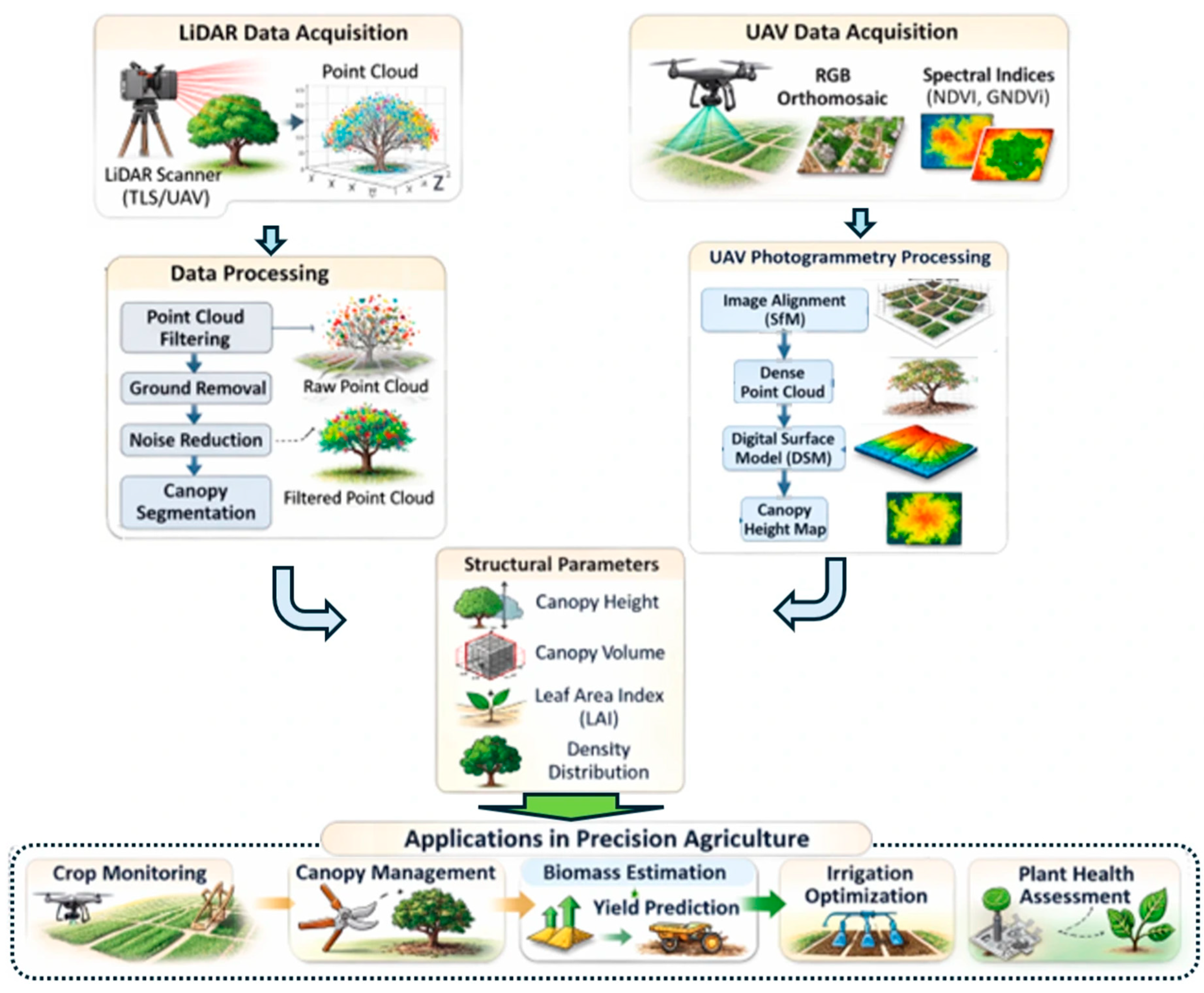
The methodological framework adopted in this study integrated LiDAR sensing, UAV photogrammetry, and voxel-based three-dimensional modelling to characterize canopy architecture and spatial variability under Mediterranean conditions. The workflow, illustrated in
Figure 1, was designed to compare active and passive remote sensing approaches for estimating canopy height, canopy volume, and vegetation density distribution. LiDAR-derived point clouds were used to reconstruct detailed three-dimensional canopy structures, including internal vegetation organization, whereas UAV photogrammetry was used to generate orthomosaics, dense point clouds, digital surface models, and canopy height models through Structure-from-Motion processing. The outputs from both approaches were compared with ground-based measurements to evaluate their accuracy, complementarity, and suitability for precision agriculture applications. Statistical indicators, including RMSE, MAE, R
2, and relative error, were used to assess the performance of the proposed multi-sensor workflow (
Figure 1).
Figure 1 illustrates the integrated workflow adopted in this study for canopy structural analysis using LiDAR sensing and UAV photogrammetry. The workflow combines LiDAR-derived point cloud acquisition and preprocessing with UAV-based RGB and multispectral image acquisition and Structure-from-Motion photogrammetric processing. The resulting datasets are used to extract key canopy structural parameters, including canopy height, canopy volume, and vegetation density distribution.
These outputs support several precision agriculture applications, such as crop monitoring, canopy management, biomass estimation, yield prediction, irrigation optimization, and plant health assessment.
2.1. Study Area
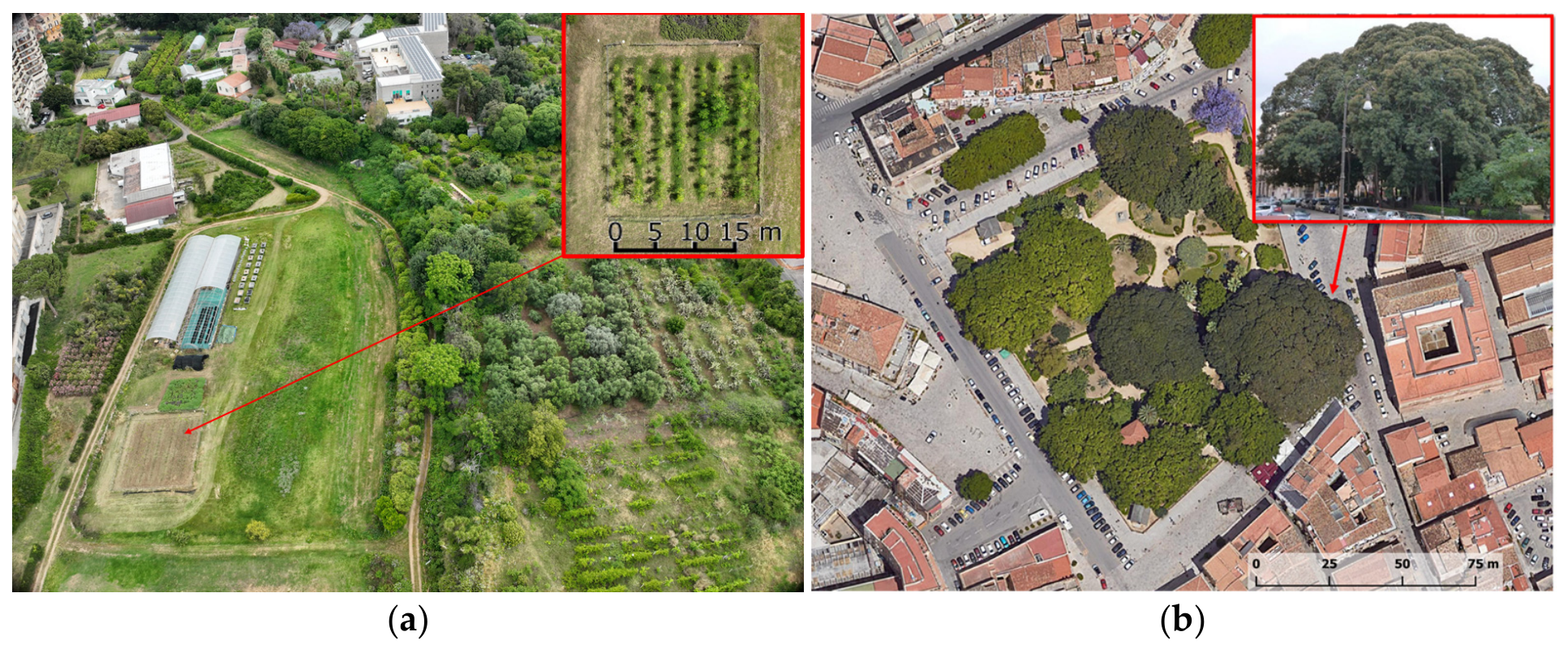
The study was conducted in Palermo, Sicily, Italy, under Mediterranean environmental conditions (
Figure 2). The first experimental site was located at the experimental farm of the University of Palermo, Department of Agricultural, Food and Forestry Sciences, within the Fossa della Garofala agricultural area (38°06′26″ N, 13°20′56″ E; approximately 30 m a.s.l.). The site is characterized by a Mediterranean climate, classified as Csa according to the Köppen–Geiger system, with mild and wet winters and hot, dry summers. Average annual precipitation ranges between 400 and 500 mm and is mainly concentrated during autumn and winter. The summer period is typically characterized by prolonged drought and high temperatures, which strongly influence plant growth dynamics and water availability.
The experimental field covered approximately 410 m2 and had relatively flat topography. The plantation consisted of Moringa oleifera Lam. trees arranged with a spacing of 3 m between rows and 1 m between plants within the row. The field was equipped with a micro-irrigation system used to provide supplemental irrigation during the dry season.
The soil of the experimental field is representative of Mediterranean agricultural soils and is characterized by a medium-textured profile, moderate calcareous content, good drainage capacity, and low-to-moderate organic matter. The plantation was established under micro-irrigated conditions, and plants were managed according to standard agronomic practices for Moringa oleifera under Mediterranean conditions. Pruning was periodically applied to control canopy height, promote lateral branching, and facilitate monitoring and field operations. These management practices were considered when interpreting canopy structural variability because pruning and irrigation influence canopy height, crown expansion, and biomass distribution. Detailed soil chemical analyses were not available for all sampled positions.
A second case study was included to evaluate sensor performance under conditions of high canopy complexity. This consisted of a mature specimen of Ficus macrophylla subsp. columnaris located in Piazza Marina, Palermo, Italy. The tree reaches approximately 21 m in height and has an extensive and complex canopy, with a trunk circumference of approximately 36 m. Although Ficus macrophylla is not an agricultural crop, it was included as a structural benchmark to test the robustness of LiDAR and UAV photogrammetry under highly complex canopy conditions. This comparison allowed sensor performance to be evaluated across contrasting canopy architectures, from the relatively open and regular structure of Moringa oleifera to a dense, multilayered, and highly heterogeneous tree canopy.
The inclusion of these two contrasting case studies allowed a comprehensive evaluation of LiDAR and UAV photogrammetric approaches under different structural conditions representative of Mediterranean environments. This experimental design was intended to assess the complementarity of UAV photogrammetry for external canopy mapping and LiDAR sensing for detailed three-dimensional structural characterization.
2.2. Plant Material and Sampling Design
Two plant types with contrasting canopy architectures were considered in this study.
Moringa oleifera Lam., a fast-growing tree species belonging to the family Moringaceae, was selected as an emerging nutraceutical crop adapted to semi-arid and Mediterranean environments. Native to the sub-Himalayan regions of northern India, the species is now widely cultivated in tropical and subtropical areas due to its high nutritional value, rapid biomass production, and adaptability to water-limited conditions [
46,
47,
48]. Under favorable conditions,
M. oleifera can reach heights between 5 and 15 m, although regular pruning is commonly applied to control plant architecture and facilitate harvesting. Its canopy is relatively open and composed of compound tripinnate leaves, producing a light and discontinuous structure that is suitable for precision agriculture monitoring.
Ficus macrophylla subsp. columnaris was included as a structurally complex tree case study. This species is characterized by dense foliage, numerous aerial roots, and a multilayered canopy architecture that forms an intricate three-dimensional structure. Although it is not an agricultural crop, F. macrophylla was used as a structural benchmark to evaluate the robustness of LiDAR sensing and UAV photogrammetry under conditions of strong canopy occlusion and high architectural complexity.
For the Moringa oleifera field, a total of 120 plants were sampled for ground-truth validation. The plants were selected to cover the full spatial variability of the experimental field, including different row positions, canopy sizes, and vigor levels. Sampling included plants located in central rows, border rows, and external field positions in order to capture possible effects of row location, light exposure, and micro-environmental variability. The selected plants covered the observed range of canopy height and crown development within the plantation, providing a representative dataset for validating remote sensing-derived structural metrics. Ground-truth measurements were collected to validate remotely sensed canopy metrics. Canopy height was measured from the soil surface to the highest living canopy point using a telescopic measuring rod. Canopy width was measured along two perpendicular directions, parallel and perpendicular to the row, using a measuring tape, and the mean crown diameter was calculated. Field-based canopy volume was estimated using simplified geometric approximations based on measured canopy height and crown diameters. Vegetation density was assessed indirectly from LiDAR-derived occupied voxels and compared with field observations of canopy compactness and visible foliage distribution. These measurements provided reference data for evaluating the accuracy of LiDAR- and UAV-derived canopy height and canopy volume estimates.
For Ficus macrophylla, the analysis was performed on the whole canopy structure as a descriptive structural benchmark, without replicated agronomic sampling. The validation design was quantitative and replicated for Moringa oleifera, whereas Ficus macrophylla was used as a descriptive structural benchmark. Therefore, inferential statistical comparisons were performed only for Moringa oleifera, while the Ficus macrophylla analysis was interpreted qualitatively and descriptively to assess sensor behaviour under high canopy complexity.
2.3. LiDAR Data Acquisition
LiDAR surveys were conducted using a Hovermap ST-X LiDAR sensor (Emesent Pty Ltd., Brisbane, Australia), operated as a mobile laser scanning (MLS) system equipped with simultaneous localization and mapping (SLAM) technology. The system integrates a multi-beam laser scanner, an inertial measurement unit (IMU), a GNSS receiver, and an onboard processing unit, allowing real-time estimation of the sensor position and orientation during data acquisition.
The LiDAR sensor operates at a wavelength of approximately 905 nm, with a scanning frequency of 200–300 kHz and a measurement range of up to 100 m. The acquisition generated point cloud densities higher than 200 points m−2, enabling detailed reconstruction of vegetation structure. These technical specifications allowed the capture of canopy elements such as stems, branches, foliage layers, and internal structural discontinuities.
During data acquisition, the LiDAR system continuously emitted laser pulses toward the surrounding vegetation while recording the return signals reflected by canopy surfaces. The SLAM algorithm simultaneously estimated the trajectory of the sensor and generated a three-dimensional point cloud of the scanned environment.
LiDAR acquisition was carried out under stable weather conditions, with low wind speed and adequate visibility, in order to minimize canopy movement and reduce noise in the point cloud. During the survey, the operator followed predefined scanning trajectories around the target vegetation. For the Moringa oleifera plantation, the acquisition trajectory consisted of walking along the inter-row spaces and around the external perimeter of the experimental field, maintaining an approximate scanning distance of 1.5 m from the plants. For Ficus macrophylla subsp. columnaris, the scanner was moved along a circular or semi-circular trajectory around the tree, maintaining an approximate distance of 6 m from the trunk and canopy projection.
This acquisition strategy allowed canopy information to be collected from multiple viewing angles, improving the completeness of the reconstructed point clouds and reducing occlusion effects. The resulting LiDAR datasets were used for three-dimensional canopy reconstruction, canopy height estimation, voxel-based canopy volume calculation, and vegetation density analysis.
2.4. UAV Photogrammetric Survey
To compare LiDAR-derived structural models with photogrammetric reconstruction, aerial imagery was acquired using a multirotor UAV platform equipped with a high-resolution RGB camera. The UAV survey was designed to obtain overlapping images suitable for Structure-from-Motion (SfM) processing and three-dimensional canopy reconstruction.
UAV flights were conducted under stable weather conditions, during the central part of the morning to reduce excessive shadow length while avoiding strong midday illumination. The flight plan followed a nadir grid pattern with 80% forward overlap and 70% side overlap. For the Moringa oleifera field, the nadir route was considered adequate because of the relatively open and regular canopy structure. For Ficus macrophylla, the limitations of nadir photogrammetry in reconstructing lateral and internal canopy structures were explicitly considered in the interpretation of results. Ground control points were distributed across the survey area and measured using GNSS to support georeferencing and elevation control of the photogrammetric model. Exact GCP positional error and independent elevation accuracy were not available for all survey areas.
The main flight parameters were as follows:
- •
flight altitude: 20–30 m above ground level;
- •
forward overlap: 80%;
- •
side overlap: 70%;
- •
ground sampling distance (GSD): approximately 1.5–2.5 cm pixel−1.
The ground sampling distance was estimated using Equation (1):
where
H = flight altitude above ground (m);
S = sensor pixel size (mm);
f = focal length of the camera lens (mm);
I = image width in pixels.
The acquired imagery was processed using Structure-from-Motion photogrammetric algorithms to reconstruct three-dimensional surface models of the study area.
2.5. Processing of LiDAR and UAV Data for Canopy Metric Extraction
LiDAR datasets were processed using the Emesent Hovermap ST-X SLAM software (Emesent Pty Ltd., Brisbane, Australia) and CloudCompare (v. 2.12.4, open-source software, GPL license) and CloudCompare v. 2.12.4, an open-source software distributed under the GNU General Public License, for point-cloud inspection, filtering, and segmentation. The LiDAR processing workflow included point cloud registration, noise filtering, outlier removal, ground point classification, terrain normalization, and vegetation segmentation.
First, raw LiDAR point clouds were registered and inspected to verify data completeness and remove acquisition artefacts. Noise filtering was performed using statistical outlier removal algorithms to eliminate isolated points and spurious returns caused by sensor noise, moving vegetation elements, or environmental disturbances. Ground points were then identified using progressive morphological filtering and used to normalize the point cloud relative to the terrain surface. This step allowed canopy height to be expressed as height above ground level. Finally, vegetation segmentation was performed to isolate canopy points from non-vegetated elements, producing a clean dataset suitable for structural and voxel-based analysis.
UAV images were processed using Agisoft Metashape Professional (version 1.7.3). The photogrammetric workflow included image alignment, sparse point cloud generation, dense point cloud reconstruction, digital surface model generation, RGB orthomosaic production, and canopy height model extraction. Image alignment was performed using high-accuracy settings, and tie points were automatically detected and matched across overlapping images. After bundle adjustment, a dense point cloud was generated using high-quality settings. The dense point cloud was then used to produce a digital surface model and an RGB orthomosaic.
A Canopy Height Model (CHM) was derived by subtracting the digital terrain model (DTM) from the digital surface model (DSM) according to Equation (2):
where
DSM = digital surface model;
DTM = digital terrain model.
The CHM represents vegetation height above ground level and was used to estimate canopy height and compare UAV-derived structural information with LiDAR-derived metrics.
The geometric quality of the LiDAR point clouds was assessed through visual inspection of overlapping scan trajectories, verification of point-cloud continuity, and comparison with ground-measured canopy dimensions. The SLAM-based acquisition was performed using closed-loop trajectories around the target vegetation to reduce drift and improve registration stability. Obvious misalignments, isolated points, and acquisition artefacts were removed during preprocessing. Although the manufacturer-reported sensor specifications support high-density mapping, absolute SLAM trajectory error was not independently measured in this study. This limitation is acknowledged in the Discussion, and future work will include independent ground control targets and repeated scan acquisitions to quantify SLAM drift, absolute positioning accuracy, and point-cloud repeatability.
2.6. Ground-Truth Measurements and Validation Procedure
Ground-truth measurements were collected to validate remotely sensed canopy metrics. Canopy height was measured from the soil surface to the highest living canopy point using a telescopic measuring rod. Canopy width was measured along two perpendicular directions, parallel and perpendicular to the row, using a measuring tape, and the mean crown diameter was calculated. Field-based canopy volume was estimated using simplified geometric approximations based on measured canopy height and crown diameters.
This approach was adopted as a practical field reference method; however, it may not fully capture irregular canopy geometry, internal gaps, or heterogeneous branch distribution.
Vegetation density was assessed indirectly from LiDAR-derived occupied voxels and compared with field observations of canopy compactness and visible foliage distribution.
No destructive biomass sampling or direct leaf area measurements were performed; therefore, vegetation density was interpreted as a relative structural indicator.
These measurements provided reference data for evaluating the accuracy of LiDAR- and UAV-derived canopy height and canopy volume estimates.
2.7. Voxel-Based Canopy Modelling
To quantitatively analyse canopy structure, the normalized LiDAR point cloud was converted into a voxel-based three-dimensional model.
Voxelization subdivides the canopy volume into regular three-dimensional grid cells. The volume of each voxel was calculated according to Equation (3):
where
, , and represent the spatial resolution of the voxel grid along the X, Y, and Z axes.
Each voxel was classified as occupied or empty according to the presence or absence of LiDAR points. Occupied voxels were used to reconstruct the three-dimensional canopy model and to describe the spatial distribution of vegetation within the canopy.
Canopy volume was calculated according to Equation (4):
where
= number of occupied voxels;
= voxel volume.
This approach allows detailed analysis of vegetation density and spatial distribution within the canopy.
The voxel-based canopy models were generated using cubic voxels. For the Moringa oleifera experimental field, a voxel size of 0.17 m × 0.17 m × 0.17 m was used, whereas for the Ficus macrophylla subsp. columnaris canopy, a voxel size of 0.90 m × 0.90 m × 0.90 m was adopted. These voxel dimensions were selected according to the different spatial scales and structural complexity of the two case studies, allowing the representation of canopy density, vertical organization, and internal structural heterogeneity. However, no formal voxel-size sensitivity analysis was performed; therefore, voxel-derived canopy density, volume, and heterogeneity metrics should be interpreted as scale-dependent descriptors.
Vegetation density distribution was calculated as the number of occupied voxels or LiDAR points within each vertical canopy layer. This approach allowed the analysis of canopy compactness, vertical structure, internal vegetation distribution, and structural heterogeneity. The voxel-based metrics were then used to compare LiDAR-derived three-dimensional canopy information with UAV-derived photogrammetric products.
2.8. Statistical Validation
Statistical analyses were performed using R software (v. 4.3.2; R Core Team, Vienna, Austria). The accuracy of LiDAR- and UAV-derived canopy metrics was evaluated by comparing the estimated values with ground-truth measurements collected in the field. The agreement between datasets was assessed using the root mean square error (RMSE), mean absolute error (MAE), coefficient of determination (R2), and relative error. The coefficient of determination (R2) was calculated between remote sensing-derived estimates, either LiDAR- or UAV-derived metrics, and the corresponding ground-truth field measurements. Therefore, R2 expresses the agreement between each sensing approach and the field reference data, not merely the correlation between LiDAR and UAV outputs.
The root mean square error (RMSE) was calculated according to Equation (5):
where
Pi is the predicted value,
Oi is the observed value, and
n is the number of observations.
The mean absolute error (MAE) was calculated according to Equation (6):
The coefficient of determination (R
2) was used to evaluate the strength of the relationship between LiDAR-derived and UAV-derived measurements according to Equation (7):
where
represents the mean of the observed values.
Relative error was calculated according to Equation (8):
where
Pi is the predicted value and
Oi is the observed value.
These metrics were used to assess the accuracy of canopy height and canopy volume estimates obtained from LiDAR and UAV photogrammetry. Normality of the data was assessed using the Shapiro–Wilk test. When the assumptions of normality were satisfied, paired comparisons between LiDAR- and UAV-derived estimates were performed using paired t-tests. When normality assumptions were not satisfied, the Wilcoxon signed-rank test was used. Statistical significance was assessed at p < 0.05.
Inferential statistical analyses were applied only to the replicated Moringa oleifera dataset, while Ficus macrophylla was used for descriptive comparison because replicated ground-truth measurements were not available.
2.9. Potential Applications for Precision Agriculture
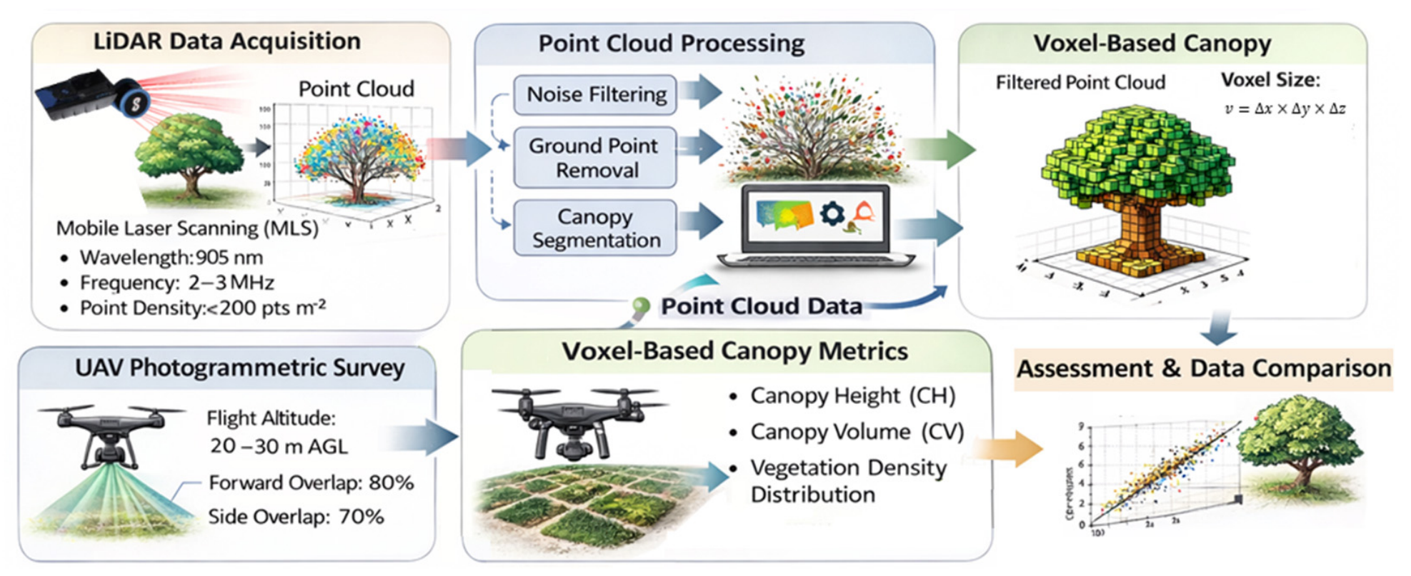
The extracted canopy structural parameters were evaluated in relation to their potential use in precision agriculture. The integration of LiDAR-derived structural information and UAV photogrammetric products enables a comprehensive characterization of vegetation architecture and spatial variability within agricultural systems (
Figure 3). In particular, canopy height, canopy volume, and vegetation density distribution provide useful indicators for biomass estimation, crop monitoring, canopy management, irrigation planning, yield prediction, and plant health assessment.
LiDAR-derived point clouds and voxel-based models allow detailed analysis of internal canopy structure, vertical heterogeneity, and vegetation density distribution. This information is particularly relevant for identifying differences in canopy compactness, biomass accumulation, and structural complexity. Conversely, UAV photogrammetry provides complementary information on external canopy morphology, canopy surface variability, and spatial patterns at field scale.
The integration of both datasets supports a multi-sensor monitoring framework for data-driven crop management in Mediterranean agricultural systems. By combining the detailed three-dimensional information provided by LiDAR with the spatial coverage and operational flexibility of UAV photogrammetry, the proposed approach can improve the interpretation of canopy development and support more precise agronomic decision-making.
Figure 3 summarizes the operational workflow used to extract and compare canopy structural metrics from LiDAR and UAV photogrammetric datasets. LiDAR data were first acquired through mobile laser scanning and processed to generate filtered point clouds suitable for voxel-based canopy modelling. In parallel, UAV photogrammetric surveys were used to derive complementary information on canopy surface structure. The resulting datasets were used to estimate canopy height, canopy volume, and vegetation density distribution and were subsequently compared through statistical analysis to assess their accuracy and consistency.
This workflow highlights the complementary role of the two sensing approaches. LiDAR-derived point clouds and voxel-based models provide detailed information on internal canopy structure and vertical vegetation distribution, whereas UAV photogrammetry supports external canopy surface mapping and spatial variability assessment. The integration of both data sources enables a more comprehensive characterization of canopy architecture and provides operational information for precision agriculture applications under Mediterranean conditions.
3. Results
The results provide a comprehensive comparative assessment of LiDAR and UAV photogrammetric approaches for canopy structural characterization, highlighting significant differences in accuracy, structural detail, and representation of vegetation architecture. The analysis focuses on canopy height estimation, canopy volume reconstruction, and the ability to capture internal canopy structure across species with contrasting morphological complexity.
3.1. Three-Dimensional Canopy Reconstruction
The comparative analysis of LiDAR sensing and UAV photogrammetry enabled the reconstruction of canopy structure for the two investigated species, Moringa oleifera and Ficus macrophylla, highlighting substantial differences in structural detail and representation accuracy between the two approaches.
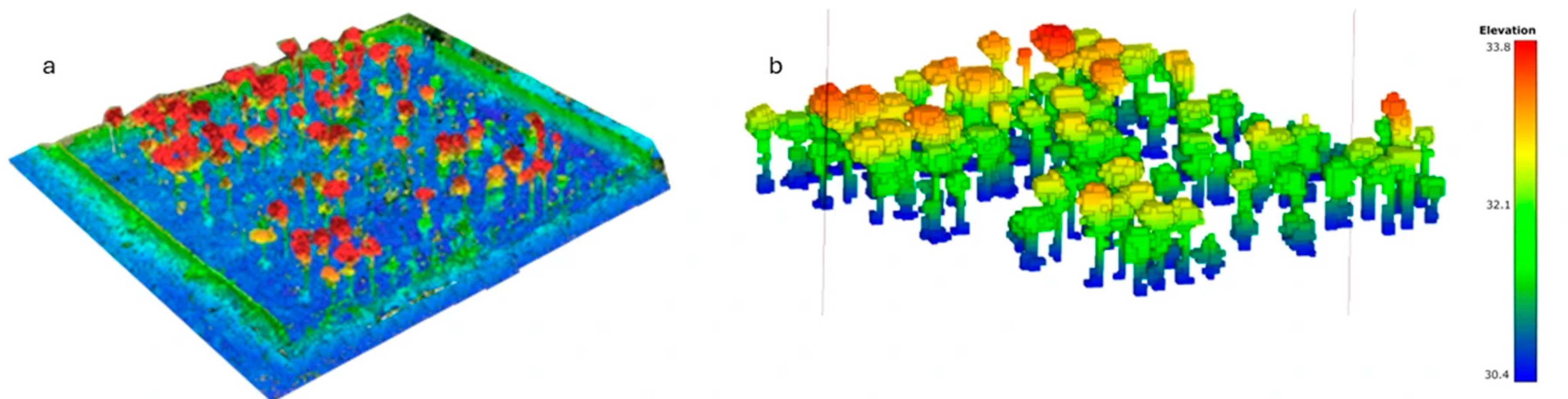
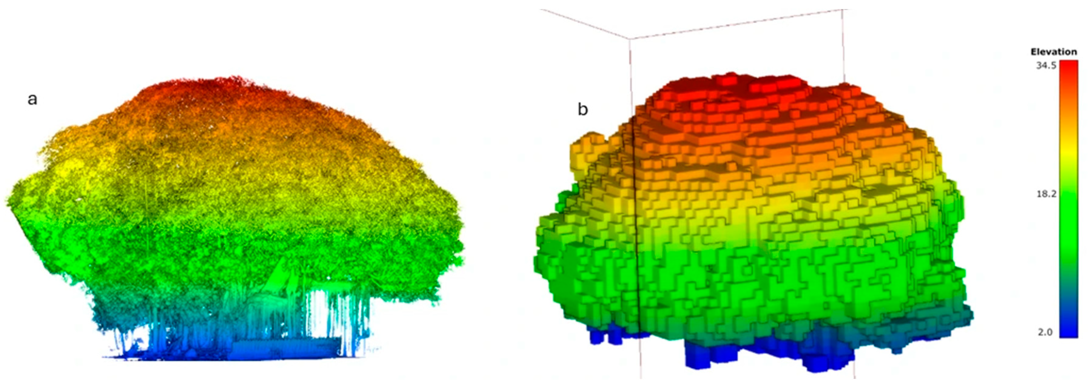
Figure 4 and
Figure 5 specifically illustrate the LiDAR-derived point clouds and the corresponding voxel-based canopy models for the two case studies.
As shown in
Figure 4 and
Figure 5, LiDAR-derived point clouds provide a highly detailed three-dimensional representation of vegetation architecture. The high density of laser returns allows accurate reconstruction of canopy elements, including stems, branches, and foliage layers. This capability is particularly evident in the voxel-based models, which describe not only the external canopy envelope but also the internal spatial distribution of vegetation.
In the case of
Moringa oleifera (
Figure 4), characterized by a relatively regular and open canopy structure, LiDAR data enabled a precise reconstruction of canopy geometry and vertical development. The voxel-based model highlights a relatively homogeneous distribution of vegetation density, with a clear differentiation between lower and upper canopy layers. This structural organization is consistent with the growth pattern of the species and facilitates the estimation of key parameters such as canopy height and canopy volume.
In contrast, the reconstruction of
Ficus macrophylla (
Figure 5) reveals a much more complex canopy architecture. The LiDAR-derived point cloud captures the dense foliage and intricate arrangement of branches and aerial roots, providing a detailed representation of internal canopy heterogeneity. The voxel-based model clearly illustrates variations in vegetation density across different canopy layers, with higher density zones concentrated in the central and upper canopy regions. These results highlight the capability of LiDAR to effectively characterize structurally complex tree species.
Because different voxel sizes were adopted for the two case studies, voxel-derived density and heterogeneity metrics were interpreted within each canopy scale rather than as direct scale-independent comparisons between species.
Vegetation density was quantified from LiDAR data as the proportion of occupied voxels within the canopy volume and as the vertical distribution of occupied voxels across height layers. In Moringa oleifera, voxel occupancy was more evenly distributed and lower canopy penetration was higher due to the open canopy structure. In Ficus macrophylla, vegetation density was concentrated in the intermediate and upper canopy layers, reflecting the dense and multilayered architecture of the tree. UAV photogrammetry did not provide reliable internal voxel occupancy information because the reconstructed point clouds mainly represented the external canopy surface. Therefore, vegetation density comparison between the two methods was interpreted in terms of internal canopy representation rather than direct one-to-one accuracy against destructive measurements.
UAV photogrammetric reconstruction, based on Structure-from-Motion techniques, provided reliable representations of the external canopy surface for both species. However, its ability to describe internal canopy structure was more limited. The resulting dense point clouds and derived surface models mainly represented the upper canopy layer, with reduced penetration into inner canopy zones due to occlusion effects caused by dense foliage.
These limitations were particularly evident in Ficus macrophylla, where the high canopy complexity reduced the effectiveness of photogrammetric reconstruction. Although the overall external canopy shape could be reconstructed, internal structural features were not adequately captured, resulting in a simplified representation of vegetation architecture. In contrast, the limitations of UAV photogrammetry were less pronounced in Moringa oleifera, owing to its more open and discontinuous canopy structure.
Overall, the results demonstrate that LiDAR-based approaches provide a more comprehensive and accurate representation of canopy structure than UAV photogrammetry, particularly under conditions of high canopy density and structural complexity. The voxel-based modelling approach further enhances this capability by enabling the quantification of vegetation distribution within the canopy volume.
The comparison between the two species also confirms that the performance of sensing technologies is strongly influenced by canopy architecture. LiDAR consistently outperformed photogrammetric approaches in capturing internal structural variability, whereas UAV-based methods remained effective for external canopy mapping and spatial variability analysis. These findings highlight the importance of selecting appropriate sensing technologies according to crop structure and monitoring objectives, particularly in precision agriculture applications where accurate canopy characterization is essential for improving crop management and decision-making.
3.2. Canopy Height and Canopy Volume Estimation
The quantitative analysis of canopy structural parameters confirms the differences observed in the three-dimensional reconstructions (
Figure 4 and
Figure 5), highlighting the superior performance of LiDAR-based approaches for both canopy height and canopy volume estimation.
Canopy height is a key structural parameter for evaluating plant growth and biomass development. LiDAR-derived canopy height models (CHMs) provided highly accurate and spatially consistent measurements across both species. The high density of laser returns and the ability to penetrate the canopy enabled reliable detection of both upper and intermediate vegetation layers, ensuring accurate height estimation at both individual plant and plot scales.
UAV-derived CHMs also provided consistent estimates, particularly for
Moringa oleifera, where the relatively open canopy reduces occlusion effects. However, as observed in
Figure 4, UAV-based estimates tend to underestimate canopy height, especially in dense vegetation. This limitation is more evident in
Ficus macrophylla (
Figure 5), where complex canopy architecture restricts the capability of photogrammetric reconstruction to capture lower canopy layers.
The statistical comparison supports these observations. Differences between LiDAR- and UAV-derived estimates were evaluated using paired statistical tests for Moringa oleifera. Normality was assessed using the Shapiro–Wilk test, and significance was evaluated at p < 0.05.
Accuracy was assessed by comparing LiDAR- and UAV-derived canopy metrics with ground-truth measurements collected in the field. As reported in
Table 1, LiDAR achieved lower RMSE values for canopy height estimation than UAV photogrammetry (0.19–0.21 m vs. 0.52–0.60 m), corresponding to an approximate error reduction of 60–65%. LiDAR also achieved higher coefficients of determination (R
2 = 0.94–0.96) than UAV photogrammetry (R
2 = 0.82–0.87). For canopy volume estimation, LiDAR showed relative errors of 3.5–4.2%, whereas UAV photogrammetry showed errors of 13.7–16.1%. These results confirm the higher reliability of LiDAR for three-dimensional structural characterization, particularly when canopy volume and internal canopy structure are relevant. These RMSE differences should be interpreted in light of the available geometric control information and the absence of independent SLAM trajectory-error and complete GCP-accuracy assessments.
The underestimation of canopy height by UAV photogrammetry increased with canopy complexity and voxel-derived vegetation density. In the more open Moringa oleifera canopy, UAV-derived height estimates showed closer agreement with LiDAR, whereas in the dense Ficus macrophylla canopy, the reduced penetration of photogrammetric reconstruction led to greater underestimation of height and canopy volume. This confirms that the performance gap between LiDAR and UAV photogrammetry increases as canopy density and structural complexity increase.
Canopy volume estimation further emphasizes the advantages of LiDAR-based analysis. The voxel-based modeling approach applied to LiDAR point clouds enabled a detailed characterization of vegetation distribution within the canopy, as illustrated in
Figure 4 and
Figure 5. This approach allows the quantification of canopy compactness and spatial variability by subdividing the canopy into volumetric elements.
LiDAR-derived canopy volume estimates showed substantially lower relative errors (3.5–4.2%) compared with UAV photogrammetric estimates (13.7–16.1%), as reported in
Table 1. These differences are mainly related to the limited ability of photogrammetric approaches to capture internal canopy structure, particularly in dense and heterogeneous vegetation.
The comparison between species highlights the influence of canopy architecture on model performance. In Moringa oleifera, UAV-based estimates show relatively good agreement with LiDAR data due to the more regular canopy structure. In contrast, in Ficus macrophylla, the dense foliage and complex branching system lead to significant underestimation of both canopy height and volume when using UAV photogrammetry.
Overall, these results confirm that LiDAR provides a more accurate and comprehensive representation of canopy structural parameters, particularly for metrics depending on the three-dimensional distribution of vegetation. The integration of voxel-based modeling further enhances structural analysis, reinforcing the suitability of LiDAR for precision agriculture applications requiring detailed canopy characterization.
3.3. Comparison Between LiDAR and UAV-Based Reconstruction
The comparative analysis between LiDAR-based scanning and UAV photogrammetric reconstruction highlights clear differences in structural accuracy, data resolution, and operational performance.
LiDAR systems provide higher structural accuracy due to their ability to generate high-density point clouds and capture multiple returns from different canopy layers. This capability enables the reconstruction of internal canopy architecture and supports detailed analysis of vegetation density distribution, as observed in
Figure 4 and
Figure 5. In contrast, UAV photogrammetry is primarily limited to the reconstruction of the external canopy surface, with reduced capability to detect internal vegetation layers due to occlusion effects.
These differences are particularly evident in Ficus macrophylla, where the dense canopy structure significantly limits the performance of photogrammetric reconstruction. While UAV-based models accurately describe the external canopy geometry, they fail to capture internal structural variability. LiDAR-based models, on the other hand, provide a comprehensive representation of canopy architecture, including internal elements that are not visible in photogrammetric data.
The main differences between LiDAR-based mobile laser scanning and UAV photogrammetry are summarized in
Table 2. Measured accuracy values from the present study are reported for canopy height and canopy volume, while additional qualitative and operational indicators describe the relative performance of the two approaches in terms of structural detail, occlusion sensitivity, vegetation density estimation, spatial coverage, acquisition cost, and processing complexity. Overall, LiDAR provided higher accuracy for canopy height and canopy volume estimation and showed greater robustness to canopy occlusion, particularly in dense and structurally complex vegetation, providing a more detailed representation of relative canopy occupancy and internal structural distribution.
Conversely, UAV photogrammetry offered advantages in terms of broader spatial coverage, lower operational cost, and simpler processing workflow, making it suitable for rapid field-scale monitoring of canopy surface variability. These results indicate that the choice of sensing technology should be guided by the monitoring objective: LiDAR is more appropriate for detailed three-dimensional structural characterization and internal canopy analysis, whereas UAV photogrammetry represents an efficient solution for large-scale mapping of external canopy morphology and spatial variability.
The table summarizes the main differences between the two approaches in terms of structural accuracy, canopy volume estimation, spatial resolution, and operational requirements. LiDAR systems provide higher accuracy in canopy height and volume estimation and allow the reconstruction of internal vegetation layers through high-density point clouds and voxel-based modeling. UAV photogrammetry offers wider spatial coverage and lower operational costs but is more affected by canopy occlusion and limitations in reconstructing internal canopy structure.
3.4. Implications for Precision Agriculture Applications
The results obtained in this study highlight the strong potential of LiDAR technology for advanced crop monitoring applications within precision agriculture frameworks. The high structural accuracy of LiDAR-derived models, as demonstrated in canopy height and volume estimation (
Table 1), makes this approach particularly suitable for applications requiring detailed three-dimensional characterization of vegetation, including biomass estimation, canopy management optimization, and yield prediction.
The ability of LiDAR systems to capture internal canopy structure, as observed in
Figure 4 and
Figure 5, provides a significant advantage for analyzing vegetation density distribution and structural heterogeneity.
Vegetation density metrics derived from occupied voxels were not independently validated using destructive biomass or leaf area measurements. Therefore, these metrics should be interpreted as indicators of relative canopy occupancy, compactness, and internal structural distribution, rather than as absolute measurements of vegetation density. The advantage of LiDAR is therefore related to its ability to represent internal canopy organization, not to a fully independent validation of true density.
This information is essential for understanding plant growth dynamics and supports the development of more accurate decision-support systems for site-specific crop management.
UAV photogrammetry, although less effective in capturing internal canopy structure, remains a valuable tool for large-scale crop monitoring due to its operational flexibility, lower cost, and capacity to rapidly acquire high-resolution spatial data. As shown in the results, UAV-based approaches provide reliable information on canopy surface variability, making them suitable for applications such as crop vigor assessment, field-scale variability mapping, and early detection of stress conditions.
From an operational perspective, UAV photogrammetry required shorter acquisition time and lower equipment cost, whereas LiDAR required more specialized equipment and longer point-cloud processing. However, LiDAR provided substantially higher structural accuracy and internal canopy information. Therefore, UAV photogrammetry is suitable for rapid field-scale mapping, while LiDAR is preferable when detailed three-dimensional canopy characterization is required. The choice between the two technologies should depend on monitoring objectives, required accuracy, field scale, and available resources.
The integration of LiDAR-derived structural information with UAV-based spatial datasets represents a promising multi-sensor approach for precision agriculture. This combined methodology enables the simultaneous analysis of canopy architecture and spatial variability, improving the accuracy and reliability of crop monitoring systems. Such integration is particularly relevant in Mediterranean environments, where heterogeneous growing conditions and water limitations require precise and adaptive management strategies.
Overall, the findings demonstrate the complementary nature of LiDAR sensing and UAV photogrammetry. While LiDAR provides high-resolution structural information, UAV-based approaches ensure efficient large-scale monitoring. The integration of these technologies offers significant potential for improving data-driven decision-making processes and advancing sustainable agricultural practices.
4. Discussion
The results of this study demonstrate the superior capability of LiDAR sensing for high-resolution three-dimensional characterization of vegetation canopy structure, particularly when compared with UAV photogrammetric approaches. The differences observed in canopy reconstruction (
Figure 4 and
Figure 5) and in the quantitative analysis of canopy height and volume (
Table 1) highlight the fundamental advantages of active sensing systems for structural vegetation analysis.
The higher accuracy achieved by LiDAR in canopy height estimation (RMSE = 0.19–0.21 m) compared with UAV photogrammetry (RMSE = 0.52–0.60 m) confirms the robustness of laser-based measurements for capturing vegetation geometry. This performance is primarily related to the active sensing mechanism of LiDAR, which directly measures distances through laser pulse return time, enabling precise geometric reconstruction of vegetation elements. Moreover, the ability of LiDAR sensors to generate multiple returns from different canopy layers allows partial penetration of dense foliage, resulting in a more complete representation of canopy architecture. These findings are consistent with previous studies reporting the high accuracy of LiDAR for vegetation structural analysis [
35,
36,
37].
In contrast, UAV photogrammetry showed lower accuracy in both canopy height and volume estimation, with systematic underestimation observed in dense canopy conditions. This limitation is directly related to the nature of Structure-from-Motion (SfM) reconstruction, which relies on visible surface features and is therefore affected by canopy occlusion. As a result, photogrammetric models primarily represent the outer canopy surface, as also observed in
Figure 4 and
Figure 5, where internal structural elements are not captured. Similar limitations have been reported in previous studies, highlighting the reduced capability of photogrammetric approaches in dense vegetation environments [
27,
28,
37,
38,
39].
The influence of canopy architecture on sensing performance is particularly evident when comparing the two study species. In Moringa oleifera, characterized by a relatively open canopy structure, UAV-based estimates showed closer agreement with LiDAR-derived measurements. In contrast, in Ficus macrophylla, the dense and multilayered canopy architecture increased occlusion, limiting the ability of UAV photogrammetry to capture internal branches and lower canopy layers. However, although Ficus macrophylla has a more complex canopy, the slightly lower LiDAR RMSE observed for this species may be related to the analysis being performed on a single large and continuous canopy structure, whereas Moringa oleifera consisted of multiple smaller plants with more variable individual geometry, row effects, and greater influence of ground-level measurement uncertainty. In small or open plants, slight differences in identifying the highest canopy point can produce proportionally larger errors. Therefore, the RMSE difference should be interpreted in relation to sampling structure, canopy scale, and measurement protocol rather than canopy complexity alone. Overall, these findings confirm that the performance gap between LiDAR and UAV photogrammetry is strongly influenced by canopy porosity, foliage density, vertical structure, and the scale of the reference measurements.
From an applied perspective, the findings align closely with the implications identified in
Section 3.4. The high structural accuracy of LiDAR-derived models makes this technology particularly suitable for precision agriculture applications requiring detailed canopy characterization, such as biomass estimation, canopy management optimization, and yield prediction. At the same time, UAV photogrammetry remains a valuable tool for large-scale monitoring due to its lower cost and operational flexibility, enabling rapid assessment of spatial variability across agricultural fields.
The integration of LiDAR structural information with UAV-derived spatial datasets therefore represents a promising multi-sensor approach. By combining detailed three-dimensional canopy characterization with high-resolution spatial monitoring, this methodology enables more accurate and scalable crop assessment, particularly in heterogeneous Mediterranean environments where structural variability strongly influences crop performance.
Despite the promising results obtained, several limitations should be acknowledged. First, the study was conducted at a relatively limited spatial scale, which may constrain the direct generalization of the findings to larger and more heterogeneous agricultural systems. Moreover, the analysis focused on two species characterized by markedly different canopy architectures. Although this contrast was useful for testing the potential of LiDAR- and UAV-derived structural metrics under different morphological conditions, further validation across a broader range of crops, canopy types, planting systems, management practices, and environmental contexts is required to assess the robustness and transferability of the proposed approach. The use of different voxel sizes for Moringa oleifera and Ficus macrophylla represents a methodological limitation. Voxel dimensions were selected according to the contrasting spatial scales of the two canopies; however, a formal voxel-size sensitivity analysis was not performed. Therefore, canopy density, volume, and heterogeneity metrics should be interpreted as scale-dependent descriptors. Future studies should test multiple voxel resolutions to quantify the sensitivity of structural metrics to voxel size and to improve comparability across canopy types.
A second limitation concerns the validation procedure. Manual ground-truth measurements, although widely adopted in agronomic and remote sensing studies, may introduce measurement uncertainty, particularly when identifying the highest living canopy point or estimating crown dimensions in irregular, dense, or heterogeneous canopies. In some cases, LiDAR-derived measurements may provide a more detailed and spatially consistent representation of canopy geometry than manual field measurements. Therefore, the validation statistics should be interpreted while considering the intrinsic uncertainty associated with the field reference data.
Another limitation is related to the lack of detailed soil chemical analyses for all sampled positions. Although the experimental conditions were broadly representative of Mediterranean agricultural environments, local variability in soil fertility, organic matter content, texture, water availability, and nutrient status may have influenced canopy development, biomass distribution, and vegetation density. Future studies should integrate high-resolution soil mapping with LiDAR- and UAV-derived canopy metrics in order to better quantify the relationships among soil heterogeneity, canopy structure, plant performance, and spatial variability within the field.
From a technical perspective, the absence of an independent quantitative assessment of SLAM trajectory error and point-cloud repeatability represents an additional limitation. In the present study, point-cloud quality was assessed through visual inspection, verification of overlapping scan trajectories, removal of evident artefacts, and comparison with ground-measured canopy dimensions. However, absolute SLAM trajectory error, horizontal and vertical accuracy, and point-cloud repeatability were not independently quantified. Future investigations should include ground control targets, independent checkpoints, and repeated LiDAR acquisitions to provide a more rigorous assessment of SLAM drift, registration stability, absolute positioning accuracy, and repeatability of derived canopy metrics.
Similarly, complete independent accuracy information for UAV ground control points was not available for all survey areas.
The reported RMSE differences between LiDAR and UAV photogrammetry should be interpreted considering the available geometric control information. Although closed-loop trajectories, overlap inspection, point-cloud continuity checks, and comparison with ground measurements were used to assess geometric consistency, independent SLAM trajectory error, repeat scan tests, and complete GCP accuracy data were not available for all survey areas. This limitation may affect the absolute confidence in the magnitude of the reported RMSE differences, although the observed trends remain consistent with the expected behaviour of active and passive sensing systems under different canopy complexities.
Although GCPs were distributed across the surveyed areas and measured using GNSS to support georeferencing and elevation control, independent positional and elevation accuracy could not be fully documented for all sites. Future UAV-based surveys should include a fully documented GCP network, independent checkpoints, and, where complex tree canopies are investigated, complementary oblique imagery to improve the reconstruction of lateral canopy surfaces and reduce uncertainties associated with canopy occlusion and photogrammetric reconstruction.
Although this study quantified canopy height, canopy volume, and vegetation density distribution, additional three-dimensional structural descriptors could further enhance the spatial characterization of canopy architecture.
Canopy volume validation should be interpreted with caution because field-based volume was estimated using simplified geometric approximations based on measured canopy height and crown diameters. Although this approach is commonly used for practical field validation, it does not fully represent irregular canopy geometry, internal gaps, or heterogeneous branch distribution. Therefore, the lower relative errors observed for LiDAR indicate stronger agreement with the adopted reference method, but they should not be interpreted as an absolute validation of true canopy volume.
Metrics such as voxel occupancy rate, vertical foliage distribution, canopy porosity, canopy compactness, gap fraction, and fragmentation-related indices may provide a more comprehensive description of canopy heterogeneity. These metrics are particularly relevant for comparing LiDAR and UAV photogrammetry, since LiDAR is able to capture both external and internal vegetation distribution, whereas UAV photogrammetry mainly reconstructs the external canopy envelope. Future work should therefore integrate these additional metrics to obtain a more complete and biologically meaningful quantification of canopy structural complexity.
Future research should also focus on extending LiDAR-based monitoring to larger spatial scales and multi-temporal datasets, enabling the assessment of canopy dynamics throughout the growing season. The integration of LiDAR with multispectral, hyperspectral, and thermal sensing could further improve the interpretation of structural, physiological, and stress-related crop responses. In addition, machine learning and deep learning approaches for automated point-cloud classification, trait extraction, and canopy structure interpretation represent promising tools for improving the scalability, efficiency, and operational applicability of LiDAR-based monitoring systems.
Overall, the present study confirms that LiDAR technology is a powerful tool for high-resolution three-dimensional canopy structural analysis. Its integration with UAV-based remote sensing can substantially enhance precision agriculture monitoring by combining detailed structural information with spatially extensive aerial observations. The proposed framework therefore provides a solid basis for the development of advanced, data-driven crop monitoring and management strategies within digital and precision agriculture systems.
Several methodological limitations should be acknowledged. First, the validation design was not fully balanced between the two case studies: Moringa oleifera was validated using replicated ground-truth measurements, whereas Ficus macrophylla was included as a descriptive benchmark for high canopy complexity. Second, canopy volume validation relied on simplified geometric approximations, which may not fully represent irregular canopy architecture. Third, vegetation density metrics derived from occupied voxels were not independently validated using destructive or direct biomass measurements and should therefore be interpreted as relative structural indicators. Fourth, independent SLAM trajectory error, repeated scan tests, and complete GCP accuracy information were not available for all survey areas, limiting the absolute confidence in the reported RMSE differences. Finally, different voxel sizes were adopted for the two case studies without a formal sensitivity analysis, making voxel-based metrics scale-dependent. These limitations do not invalidate the observed trends but suggest that future studies should include replicated structurally complex canopies, independent geometric controls, repeated scans, destructive or TLS-based reference measurements, and voxel-resolution sensitivity tests.




 ,
,