


Highlights
What are the main findings?
- A novel Dual-Branch Cross-Scale Fusion Network (DBCF-Net) is proposed, utilizing a pseudo-Siamese architecture to handle the distinct statistical distributions of heterogeneous satellite and UAV data.
- The Difference-Aware Attention Module (DAAM) and the Adaptive Gated Fusion Module (AGFM) were developed to mitigate radiometric shifts and extreme resolution disparities.
What are the implications of the main findings?
- The model achieves superior boundary precision and noise suppression, significantly outperforming state-of-the-art methods on the HSUD dataset.
- With high inference efficiency, DBCF-Net provides a robust technical framework for real-time disaster response and sustainable urban monitoring.
Abstract
Heterogeneous change detection (HCD) using satellite and Unmanned Aerial Vehicle (UAV) imagery is a pivotal task in remote sensing and Earth observation. However, the effective utilization of such multi-source data is significantly hindered by extreme spatial resolution disparities and distinct radiometric characteristics. Existing deep learning methods, often based on weight-sharing Siamese architectures, struggle to bridge these domain gaps, leading to spectral pseudo-changes and blurred detection boundaries. To address these challenges, we propose a novel Dual-Branch Cross-Scale Fusion Network (DBCF-Net) specifically tailored for heterogeneous satellite–UAV change detection. We introduce a Difference-Aware Attention Module (DAAM) to explicitly align cross-modal feature spaces and suppress domain-related noise through a hybrid local–global attention mechanism. Furthermore, an Adaptive Gated Fusion Module (AGFM) is designed to dynamically weight multi-scale interactions, ensuring the preservation of high-frequency spatial details from UAV imagery while maintaining the semantic consistency of satellite data. Extensive experiments on the Heterogeneous Satellite–UAV Dataset (HSUD) demonstrate that DBCF-Net achieves state-of-the-art performance, reaching an F1-score of 88.75% and an IoU of 80.58%. This study provides a robust technical framework for heterogeneous sensor fusion and high-precision monitoring in complex remote sensing scenarios.
1. Introduction
1.1. Background and Motivation
Accurate and timely monitoring of Earth surface dynamics is a fundamental task in the field of remote sensing, providing indispensable data for various Earth observation applications. In an era marked by rapid urbanization and frequent natural disasters, these technical capabilities are essential to meet the United Nations Sustainable Development Goal 11 (SDG 11), which emphasizes the urgent need to make human settlements inclusive, safe, resilient, and sustainable [1]. Beyond policy frameworks, the realization of this vision demands robust image processing solutions to support critical actions such as resilient urban planning [2], high-precision post-disaster assessment [3,4], and ecosystem conservation [5,6]. Consequently, Change Detection (CD)—the technique used to identify state differences in objects or phenomena over time—has emerged as a cornerstone technology for sophisticated land-cover interpretation and environmental monitoring [7].
In the past decade, the rapid advancement of Deep Learning (DL) has revolutionized the field of remote sensing [8,9]. Unlike traditional change detection methods that rely on hand-crafted features (e.g., CVA [10], PCA [11], MAD [12]), DL-based approaches automatically learn hierarchical representations from multi-source data, significantly improving detection accuracy [13]. Specifically, Siamese Convolutional Neural Networks (CNNs) have become the dominant paradigm for homogeneous change detection [14]. Daudt et al. [15] established the baseline FC-Siam architectures, while subsequent works introduced advanced attention mechanisms to capture long-range dependencies, such as DASNet [16], STANet [17], and ADS-Net [18]. More recently, Transformer-based models like BIT [19], ChangeFormer [20], and SwinSUNet [21] have further pushed the state-of-the-art in spectral-spatial feature modeling. Furthermore, frontier architectures such as state space models like ChangeMamba [22] and generative diffusion models [23,24] have demonstrated remarkable potential in capturing complex spatio-temporal dependencies.
However, most existing methods are designed for homogeneous data, assuming that bi-temporal images are acquired by the same sensor with identical resolutions and spectral characteristics [5]. In practical emergency scenarios—such as earthquakes, floods, or landslides—acquiring such ideal homogeneous data is often infeasible due to satellite revisit cycles or cloud cover [25]. To overcome these bottlenecks and ensure continuous monitoring for sustainability, the synergistic use of heterogeneous data becomes imperative. A paramount strategy for time-critical monitoring is to combine pre-event historical satellite imagery (providing macro-scale baselines) with post-event Unmanned Aerial Vehicle (UAV) imagery (providing on-demand, high-resolution details) [26,27]. This satellite–UAV collaboration offers a flexible and efficient solution for rapid response, effectively bridging the temporal gap between pre-event archival data and post-event situational awareness by synergizing the macro-scale coverage of satellites with the on-demand, micro-scale fidelity of UAVs.
It is important to clarify the scope of “heterogeneous” in the context of this study. While traditional heterogeneous change detection often refers to inter-modal data, such as Optical and Synthetic Aperture Radar (SAR) imagery, defining extreme cross-platform optical disparities as “heterogeneous” has become an established convention in recent literature [27,28,29]. In this paper, “heterogeneous” specifically denotes the severe intra-modal heterogeneity (i.e., cross-sensor and cross-scale disparities) between historical satellite and post-event UAV imagery. Unlike homogeneous CD (e.g., using bi-temporal satellite images with identical 0.5 m resolution), our task faces a massive 8-fold spatial resolution gap (0.5971 m vs. 7.465 cm) coupled with unpredictable radiometric shifts caused by different imaging sensors, flight altitudes, and atmospheric conditions. Overcoming this specific type of cross-platform heterogeneity is the primary focus of DBCF-Net.
1.2. Challenges in Heterogeneous Change Detection
Despite its operational value, heterogeneous change detection (HCD) poses formidable challenges that render standard homogeneous models ineffective [30]. These challenges stem from the fundamental physical and geometric discrepancies between modalities:
- Extreme Scale Variation: Satellite images typically have lower spatial resolutions (e.g., 0.5 m–10 m), whereas UAV images offer centimeter-level details (e.g., 2 cm–10 cm) [31]. This leads to the “mixed pixel” problem, where a single satellite pixel corresponds to complex textures in the UAV image, causing severe semantic ambiguity where the network struggles to distinguish true object boundaries from internal texture variations within the coarse satellite footprint. This discrepancy not only complicates feature alignment but also hinders the network from learning consistent semantic representations across views.
- Radiometric and Spectral Shift: Different sensors possess distinct spectral response functions. Coupled with varying atmospheric conditions and solar angles, this results in a significant domain shift [32]. Unchanged objects may exhibit drastically different colors and intensities, leading to widespread “pseudo-changes” that confound conventional distance-based metrics [33].
- Viewpoint and Geometric Distortion: UAVs often fly at lower altitudes with variable look angles, introducing relief displacement and occlusions compared to the nadir-view satellite imagery. These geometric disparities result in inevitable spatial misalignment. Consequently, standard pixel-to-pixel comparison methods (e.g., direct subtraction) become unreliable, necessitating a learning-based framework capable of establishing robust feature correspondences despite spatial shifts [34].
1.3. Contributions
To address these sustainability-critical challenges, this paper proposes the Dual-Branch Cross-Scale Fusion Network (DBCF-Net). We argue that effective heterogeneous CD requires distinct feature extraction followed by interaction-aware alignment.
Specifically, we adopt a pseudo-Siamese architecture with independent backbones to respect the modality-specific characteristics. To bridge the domain gap, we introduce a Difference-Aware Attention Module (DAAM). This module leverages a hybrid attention mechanism to recalibrate features spatially, thereby suppressing domain-related noise and mitigating misalignment caused by geometric distortions. Furthermore, to overcome the resolution disparity, we introduce an Adaptive Gated Fusion Module (AGFM) that dynamically weighs the feature interaction, ensuring that the final map synergizes the semantic consistency of satellite data with the fine-grained spatial fidelity of UAV imagery.
The main contributions of this study are summarized as follows:
- We collect and construct a novel Heterogeneous Satellite–UAV Dataset (HSUD), which serves as a primary contribution of this work. By providing rigorously registered image pairs with extreme spatial resolution gaps and radiometric shifts, HSUD addresses the scarcity of cross-platform benchmarks and provides a highly challenging, realistic evaluation platform for the remote sensing community.
- Framework: We propose DBCF-Net, a specialized framework for heterogeneous satellite–UAV change detection that effectively handles extreme resolution disparities, providing a robust tool for disaster response.
- Module (Alignment): We design DAAM to explicitly align cross-source features and suppress radiometric pseudo-changes.
- Module (Fusion): We introduce AGFM to progressively fuse multi-scale features, significantly improving boundary accuracy for precise damage assessment.
- Validation: Extensive experiments on the Heterogeneous Satellite–UAV Dataset (HSUD) demonstrate that DBCF-Net yields superior performance, outperforming current state-of-the-art methods [15,16,29,35].
1.4. Related Work
1.4.1. Deep Learning for Homogeneous Change Detection
Deep Learning (DL) has achieved remarkable success in change detection (CD) by automatically learning hierarchical representations from raw data. The majority of existing methods follow the Siamese framework, which utilizes weight-sharing encoders to extract features from bi-temporal images. Daudt et al. [15] proposed three pioneering Fully Convolutional Siamese (FC-Siam) architectures, establishing a strong baseline for the field. Subsequently, numerous studies have integrated attention mechanisms to enhance feature discriminability. For instance, DASNet [16] employs a dual-attention mechanism to capture long-range dependencies, while STANet [17] utilizes a spatial-temporal attention module to align features. More recently, Transformer-based models, such as BIT [19] and ChangeFormer [20], have been introduced; subsequently state-of-the-art architectures like Mamba [22] and generative diffusion models [23,36] have further pushed the boundaries of detection accuracy.
While these methods perform well on homogeneous datasets (e.g., Satellite-to-Satellite), they rely heavily on the assumption that the pre- and post-event images share the same sensor characteristics and spatial resolution. When applied to heterogeneous satellite–UAV pairs, the weight-sharing mechanism fails to accommodate the distinct statistical distributions of the two modalities, leading to suboptimal performance [5].
1.4.2. Heterogeneous Change Detection
Heterogeneous CD aims to detect changes across multi-source images. Existing approaches can be broadly categorized into two strategies: image-to-image translation and feature space alignment.
Generative Models (GANs and Diffusion): This strategy attempts to bridge the domain gap by transforming images from one domain to another or generating aligned features. Early works utilized Generative Adversarial Networks (GANs), such as CycleGAN-CD [37] and conditional adversarial networks [38], to generate homogeneous-like image pairs. Although visually appealing, GANs are prone to mode collapse and “hallucinations.” More recently, Denoising Diffusion Probabilistic Models (DDPMs) have emerged as a powerful generative paradigm. Methods like Bi-DiffCD [35] and other diffusion-based approaches [23,36] utilize iterative denoising processes to model complex data distributions, achieving superior generation quality compared to GANs. However, the iterative denoising process inherent in diffusion models necessitates substantial computational resources and multiple sampling steps. This leads to computational efficiency and high latency, which remains a significant challenge for rapid sustainability monitoring and time-sensitive emergency response.
Feature Space Alignment: A more direct approach is to map heterogeneous data into a common latent feature space. Symmetric networks (SCCN [39]) and pseudo-Siamese networks typically employ encoders with unshared weights to extract modality-specific features. To handle resolution differences, Li et al. [40] proposed a super-resolution-based approach, while others have explored Graph Neural Networks (GNNs) [41] to model topological relationships. However, most of these methods rely on simple element-wise addition or concatenation for feature fusion. They lack explicit mechanisms to correct the spatial misalignment caused by the extreme scale variation between satellite and UAV imagery, often resulting in blurred boundaries [42,43].
1.4.3. Attention and Multi-Scale Fusion Mechanisms
Attention mechanisms have become a staple in computer vision for guiding models to focus on informative regions. Representative architectures, such as SE-Net [44] and CBAM [45], utilize channel and spatial attention to recalibrate feature responses. However, in the context of heterogeneous change detection, standard self-attention mechanisms primarily focus on intra-modal feature enhancement. They often lack the explicit capacity to model the complex radiometric and structural discrepancies inherent between disparate sensors. Consequently, there remains a critical need for a more specialized attention mechanism that can leverage cross-modal discrepancy cues to suppress domain-related noise and emphasize semantic changes.
Furthermore, effectively fusing features from different scales is essential for recovering spatial details in segmentation tasks. While classic architectures like U-Net [14] and FPN variants rely on static fusion strategies such as fixed summation or concatenation, these methods frequently fail to account for the severe information imbalance between heterogeneous data sources. Although recent developments in Selective Kernel Networks [46] suggest that dynamic feature selection is more effective than static fusion, its potential for bridging the extreme resolution gap between satellite and UAV imagery remains largely underexplored. This gap in existing fusion strategies necessitates a more adaptive approach to balance the contributions of multi-source features during the reconstruction process.
2. Materials and Methods
2.1. Overview of the Proposed Network
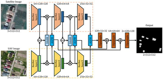
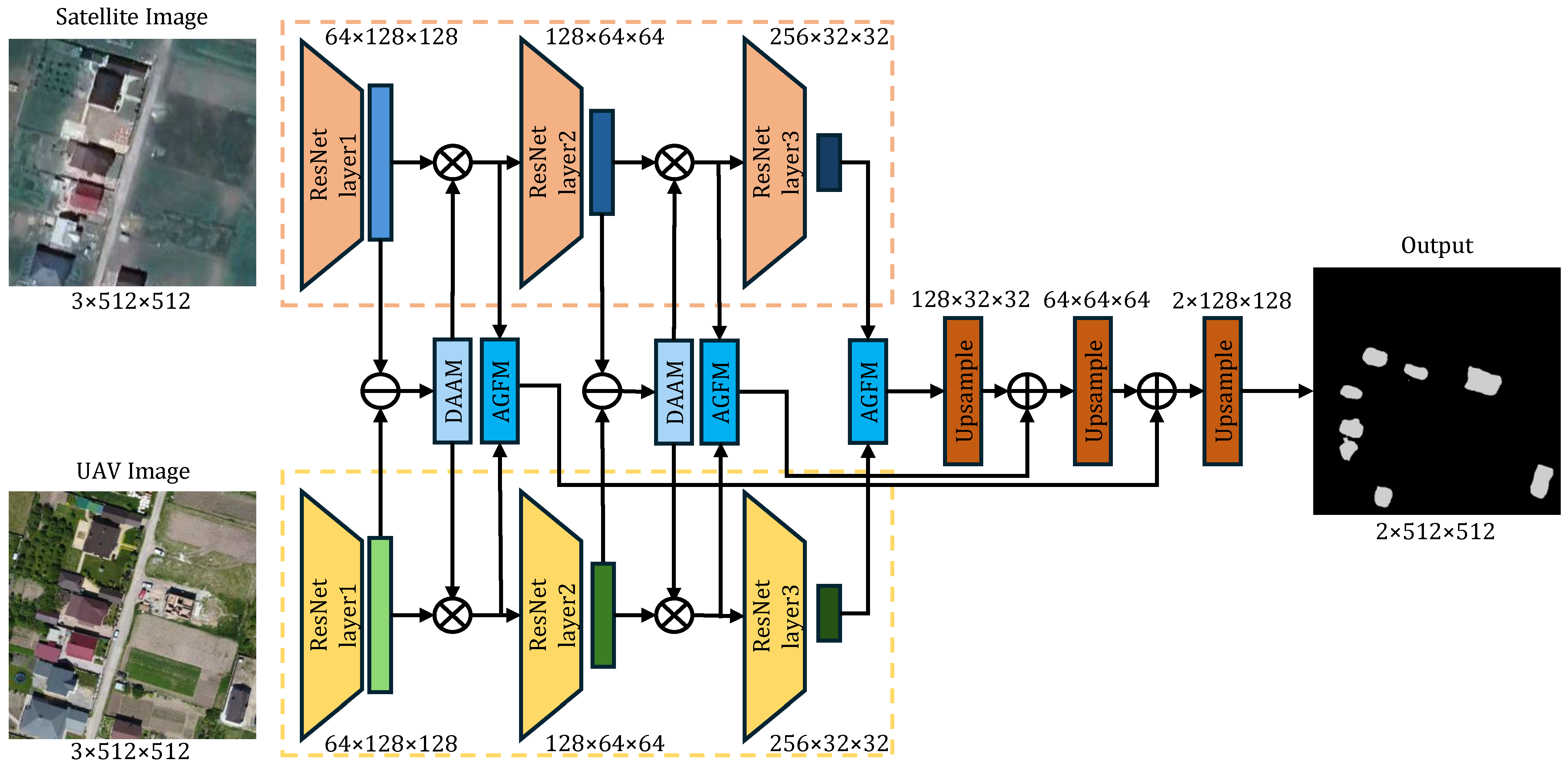
In this study, we propose a Dual-Branch Cross-Scale Fusion Network (DBCF-Net) designed to effectively segment targets by leveraging heterogeneous data sources. As illustrated in Figure 1, the network adopts a Pseudo-Siamese encoder-decoder architecture. Unlike traditional weight-sharing Siamese networks that assume consistent feature distributions, our encoder consists of two weight-independent backbones. This uncoupled design allows the network to learn modality-specific representations for satellite imagery (characterized by low resolution and rich semantics) and UAV imagery (characterized by high resolution and fine-grained textures), respectively.
Figure 1.
The overall architecture of the proposed Dual-Branch Cross-Scale Fusion Network (DBCF-Net). The network employs a pseudo-Siamese ResNet backbone to independently process heterogeneous satellite and UAV inputs. The Difference-Aware Attention Module (DAAM) is explicitly integrated to perform cross-modal feature alignment, while the Adaptive Gated Fusion Module (AGFM) dynamically aggregates features. Tensor dimensions are annotated as along the data flow pathways to illustrate hierarchical spatial and channel transformations.
To bridge the domain gap and align features between the two modalities, we introduce a Difference-Aware Attention Module (DAAM) at the early stages of the encoder. This module serves as a “soft aligner,” recalibrating feature responses based on detected discrepancies. In the decoder stage, an Adaptive Gated Fusion Module (AGFM) is employed to merge high-level semantic information with low-level spatial details progressively. Finally, the fused features are upsampled via bilinear interpolation to generate the dense segmentation map.
2.2. Feature Extraction Backbone: The Pseudo-Siamese Strategy
We utilize ResNet-34 pre-trained on ImageNet as the backbone for feature extraction. Let and denote the input satellite and UAV images, respectively. A critical design choice in DBCF-Net is the use of a Pseudo-Siamese strategy. Since satellite and UAV images differ significantly in spectral response functions and spatial resolution, forcing two branches to share weights (as in standard FC-Siam) would restrict the network’s optimization capability. Therefore, the parameters of the satellite branch and the UAV branch are updated independently:
where represents the hierarchical stages (Layer1, Layer2, Layer3). The spatial resolution decreases by a factor of 2 at each stage, while the channel dimension expands to capture richer semantic contexts.
2.3. Difference-Aware Attention Module (DAAM)
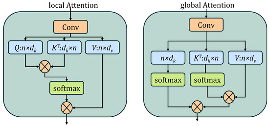
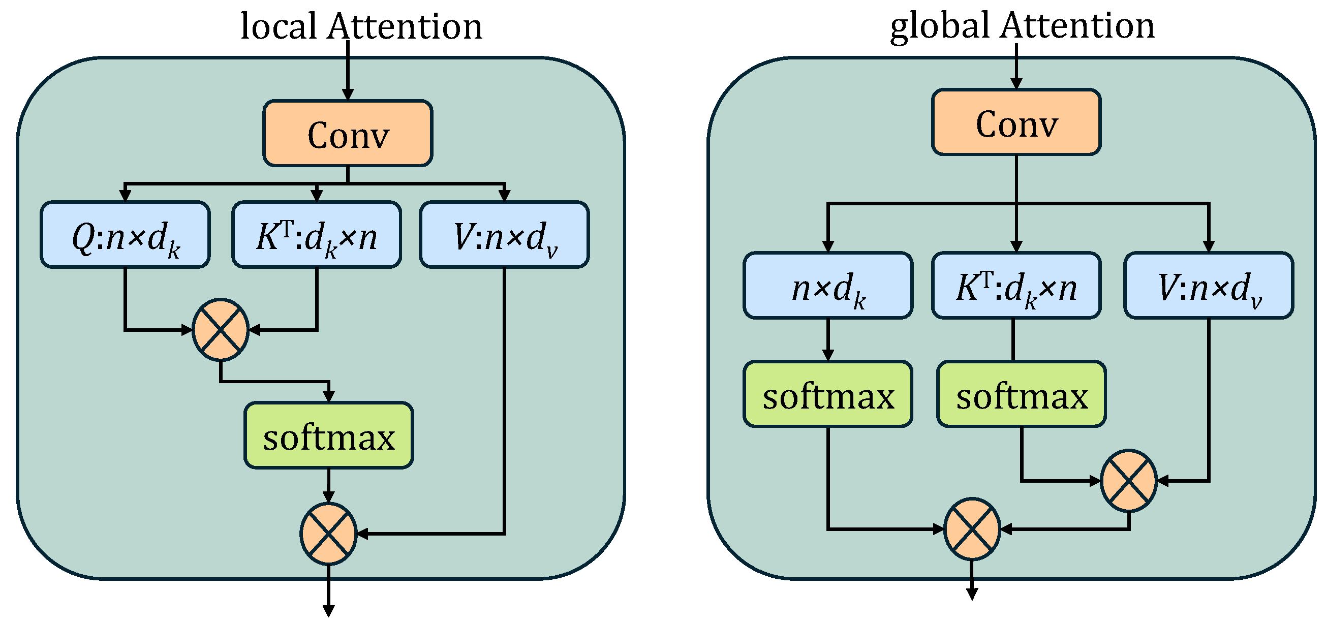
Given the distinct viewing angles and resolutions of satellite and UAV data, direct concatenation or subtraction often introduces significant noise. To address this, we propose the Difference-Aware Attention Module (DAAM). As shown in Figure 2, DAAM is inserted after the first two stages of the backbone to perform early-stage feature alignment.
Figure 2.
The architecture of the proposed Difference-Aware Attention Module (DAAM).
2.3.1. Difference Feature Generation
Let and represent the input feature maps from the satellite and UAV branches, respectively. First, we model the “discrepancy” between modalities explicitly. Instead of simple subtraction, we employ a learnable difference operation:
where denotes a composite function of a Convolution, Batch Normalization (BN), and ReLU activation. This learnable difference map D highlights regions with potential semantic changes while suppressing background consistencies. D is then split along the channel dimension into a local branch and a global branch , both with dimension . This decoupled design strategy allows the network to simultaneously model high-frequency boundary details (via local attention) and low-frequency semantic contexts (via global attention) in parallel subspaces, thereby preventing the mutual interference between micro-texture discrepancies and macro-scale object changes.
2.3.2. Dual-Path Attention Mechanism
To capture both fine-grained boundary details and long-range contextual dependencies, DAAM employs a hybrid attention mechanism:
Local Path (Detail Modeling): The local branch utilizes standard self-attention to capture short-range dependencies. We generate query , key , and value projections from . The local attention map is calculated as:
where is the scaling factor. This path focuses on refining local edge information within the difference map.
Global Path (Linearized Context Modeling): Standard self-attention has a computational complexity of , which is prohibitive for high-resolution feature maps. To aggregate global context efficiently, we adopt a linearized attention mechanism. The query , key , and value are generated from . Crucially, we apply the Softmax operation to and across specific dimensions before multiplication, changing the computation order:
By computing first, the complexity is reduced to , making it feasible to capture global dependencies across the entire image.
2.3.3. Feature Gating and Refinement
The outputs from both paths are concatenated and projected back to the original channel dimension to form the refined difference representation . This representation serves as a “spatial gate” to recalibrate the original backbone features:
where is the Sigmoid function. This gating mechanism enhances features in changed regions while suppressing those in unchanged or noisy regions.
2.4. Adaptive Gated Fusion Module (AGFM)
In the decoder stage, the simple addition of multi-scale features often leads to the “washing out” of high-frequency details from the UAV branch. To mitigate this, we employ the Adaptive Gated Fusion Module (AGFM).
Given the upsampled feature maps (Satellite) and (UAV), AGFM learns a spatial similarity map to dynamically weight the fusion. First, we compute the pixel-wise correlation:
where the summation aggregates channel information, resulting in a spatial map . A high value in S indicates strong semantic alignment between the two sources, while a low value implies discrepancy or noise.
The final fused output is obtained via a complementary competition mechanism:
This formulation functions as a soft selector: in regions where satellite features provide clear semantic guidance, the network can adjust S to prioritize ; conversely, in regions requiring fine-grained textures (e.g., building edges), it prioritizes . This ensures that the fused features retain the most discriminative characteristics from both modalities.
2.5. Decoder and Hierarchical Aggregation
The decoder follows a coarse-to-fine paradigm to progressively recover spatial details. As depicted in Figure 1, the fusion strategy is hierarchical:
- Stage 1 (Deep Fusion): The deepest semantic features and are fused via AGFM to produce the initial coarse change map .
- Stage 2 (Intermediate Fusion): is upsampled and added to the fused features from the second stage (), generating . This step recovers mid-level structural information.
- Stage 3 (Shallow Fusion): Finally, is combined with the high-resolution features from the first stage ().
The final prediction is obtained by passing the aggregated features through a projection convolution layer and upsampling to the original size of . This multi-stage design ensures that the final change map benefits from both the robust semantics of deep layers and the precise boundaries of shallow layers.
3. Results
3.1. Experiment Design
3.1.1. Datasets
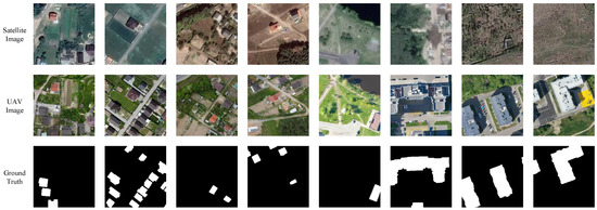
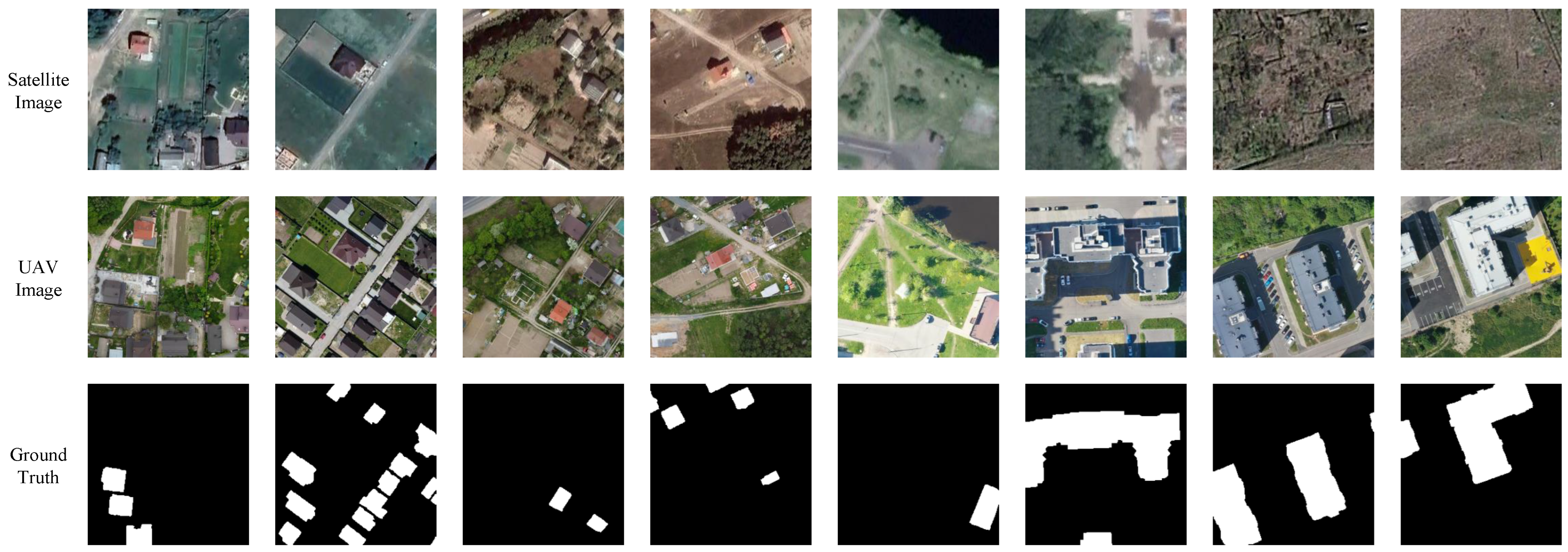
To comprehensively evaluate the performance of change detection models under severe intra-modal heterogeneity, our research team collected, annotated, and constructed a novel dataset, namely the Heterogeneous Satellite–UAV Dataset (HSUD), as illustrated in Figure 3. As a primary contribution of this study, HSUD is specifically designed to bridge the data gap in cross-platform emergency response scenarios. This dataset covers the Vinnytsia Oblast region and its surrounding areas, capturing the rapid urbanization and land-use changes occurring in this locale.
Figure 3.
Representative samples from the constructed Heterogeneous Satellite–UAV Dataset (HSUD). The rows from top to bottom represent: (1) Pre-event historical satellite images; (2) post-event UAV images acquired for rapid monitoring; and (3) ground truth change masks, where white pixels indicate changed regions. The samples demonstrate significant differences in spatial resolution, viewing angles, and spectral properties between the two data sources.
The HSUD comprises bi-temporal image pairs spanning a seven-year interval. The pre-event images were acquired from historical satellite data in 2014 via Google Earth (https://www.google.com/earth/, accessed on 2 August 2024), while the post-event images were obtained from UAV flights in 2021 via Open Aerial Map (https://map.openaerialmap.org/, accessed on 2 August 2024). A critical feature of this dataset is the extreme difference in spatial resolution: the satellite imagery has a ground resolution of approximately 0.5971 m, whereas the UAV imagery offers ultra-high-resolution details at 7.465 cm. This nearly 8-fold resolution gap introduces significant scale challenges, making HSUD an ideal benchmark for evaluating cross-scale fusion capabilities.
To ensure spatial consistency between the historical satellite imagery and post-event UAV imagery in the HSUD dataset, we performed a rigorous multi-stage registration workflow using QGIS. Initially, coarse alignment was conducted based on sensor-derived metadata and geographic coordinates. Subsequently, fine-grained registration was implemented by manually selecting distinctive ground control points (GCPs) across the heterogeneous pairs, focusing on stable corner features of buildings and road intersections. Despite the extreme viewpoint differences and geometric distortions inherent in low-altitude UAV maneuvers, the average registration error (Root Mean Square Error, RMSE) was maintained at approximately 5 pixels relative to the satellite resolution. This level of alignment ensures that the detected changes are dominated by semantic evolution rather than geometric offsets, while still providing a realistic testbed for evaluating the spatial robustness of DBCF-Net.
The annotation strategy of HSUD is specifically focused on urban areas. Anthropogenic changes, including the construction of new buildings and other man-made urban features, were meticulously manually labeled at the pixel level. Conversely, natural phenological changes (e.g., seasonal vegetation growth) were ignored to ensure the model focuses on semantically meaningful changes. Consequently, the dataset provides high-quality pixel-level ground truth labels, making it highly suitable for training and evaluating supervised learning models for heterogeneous change detection.
The final dataset consists of 674 image pairs. For experimental evaluation, we randomly partitioned the dataset into training, validation, and testing sets following a ratio of 8:1:1. Specifically, the training set contains 540 pairs, while the validation and testing sets contain 67 pairs each. During the data loading process, all original images were cropped and resized to a unified resolution of pixels to fit the network input requirements.
It is crucial to note that while resizing operations align the tensor dimensions () for network ingestion, they do not eliminate the inherent physical scale gap. Specifically, the upsampling of low-resolution satellite imagery merely interpolates pixel values without adding actual high-frequency spatial details. Consequently, a single ‘interpolated’ satellite pixel still semantically corresponds to a complex aggregation of textures in the UAV imagery, preserving the ‘mixed pixel’ challenge. Therefore, the network must intrinsically resolve this severe multi-scale ambiguity internally, which fundamentally motivates our design of the Adaptive Gated Fusion Module (AGFM).
3.1.2. Implementation Details
The proposed method was implemented using the PyTorch 2.1.0 deep learning framework. All experiments were conducted on a workstation equipped with a single NVIDIA GeForce RTX 4090 GPU with 24GB of memory.
3.1.3. Training Settings
To prevent overfitting given the limited dataset size, we applied online data augmentation techniques via the Albumentations pipelines. Specifically, the training images underwent random horizontal flipping with a probability of 0.5 and random vertical flipping with a probability of 0.3.
The network was trained using the Stochastic Gradient Descent (SGD) optimizer with a momentum of 0.9 and a weight decay of . The initial learning rate was set to . We employed a Cosine Annealing learning rate scheduler to gradually decay the learning rate over the training process, ensuring better convergence to the global optimum. The batch size was set to 4, and the model was trained for a maximum of 300 epochs.
3.1.4. Loss Function
To address the potential class imbalance between changed and unchanged regions, we formulated a hybrid loss function combining Cross-Entropy (CE) loss and Dice loss. The total loss is defined as:
Based on empirical experiments, the weights were set to and , effectively balancing pixel-wise classification accuracy with region-based overlap optimization.
3.1.5. Comparison with Other Methods
It is important to note that while numerous change detection models have been proposed recently, the vast majority are tailored for homogeneous data and struggle with the extreme 8-fold resolution gap addressed in this study. Therefore, we carefully curated our baselines to prioritize task relevance and architectural diversity. These methods cover classic fully convolutional networks, specialized cross-platform attention models, and the latest generative diffusion models:
- FC-EF, FC-Siam-Diff, and FC-Siam-Conc [15]: These are the baseline fully convolutional Siamese networks for change detection, representing early fusion, difference-based, and concatenation-based strategies, respectively.
- DASNet [16]: A dual-attentive fully convolutional Siamese network that employs a dual-attention mechanism to capture long-range dependencies and suppress pseudo-changes.
- SUNet [29]: A Siamese U-Net based architecture that combines Siamese networks with U-Net connections for robust multi-scale feature extraction in changing environments.
- Bi-DiffCD [35]: The latest diffusion-based generative method designed for arbitrary-modal change detection. It utilizes a bidirectional diffusion process to bridge the domain gap between heterogeneous images, representing the current state-of-the-art in this field.
For a fair comparison, all competing methods were retrained on the HSUD dataset using their official implementations and default hyperparameter settings.
3.1.6. Evaluation Metrics
To quantitatively evaluate the segmentation performance, we employed five standard metrics commonly used in remote sensing tasks: Precision (P), Recall (R), F1-score (), Overall Accuracy (), and Intersection over Union (). These metrics are defined based on the number of True Positives (TP), False Positives (FP), True Negatives (TN), and False Negatives (FN):
Precision measures the correctness of the positive predictions, while Recall measures the completeness. The F1-score provides a harmonic mean of Precision and Recall. Overall Accuracy represents the ratio of correctly classified pixels to the total number of pixels. IoU evaluates the overlap between the predicted segmentation map and the ground truth, serving as a rigorous measure of segmentation accuracy.
It is worth noting that in typical change detection scenarios, the unchanged background pixels significantly outnumber the changed pixels, leading to a highly imbalanced class distribution. Consequently, Overall Accuracy (OA) can sometimes be an over-optimistic metric. Therefore, in our evaluations, we place greater emphasis on the F1-score and IoU, as they strictly measure the model’s precise capability to detect actual changes while penalizing false positives and false negatives.
3.2. Experiment
In this section, we present the experimental results of the proposed DBCF-Net on the HSUD dataset. The performance is evaluated quantitatively using standard metrics and qualitatively through visual inspection of the segmentation maps.
3.2.1. Quantitative Comparison with State-of-the-Art Methods
We compared DBCF-Net with six widely used change detection methods. These baselines cover three categories: (1) standard Siamese networks (FC-Siam-Diff, FC-Siam-Conc, FC-EF); (2) attention-based networks (DASNet, SUNet); and (3) the latest diffusion-based generative method (Bi-DiffCD), which represents the current state-of-the-art in heterogeneous change detection. The quantitative evaluation results are reported in Table 1.
Table 1.
Quantitative comparison results on the HSUD dataset.
As indicated in Table 1, the proposed DBCF-Net achieves the highest scores across all five evaluation metrics. Specifically, it reaches an F1-score of 0.8875 and an IoU of 0.8058.
Among the comparison methods, FC-EF achieved the second-best overall performance with an IoU of 0.7371. The diffusion-based method Bi-DiffCD followed closely with an IoU of 0.7148. Interestingly, while Bi-DiffCD achieved a higher Recall (0.8333) than FC-EF (0.8178), its Precision (0.8341) was lower. This suggests that the generative nature of the diffusion model helps in identifying more change regions (reducing missed detections) but may introduce some noise or over-generated artifacts compared to the direct early fusion strategy of FC-EF.
Among the comparison methods, FC-EF demonstrates robust performance with an IoU of 0.7371, effectively outperforming both the attention-based methods (DASNet, SUNet) and the diffusion-based method (Bi-DiffCD). Interestingly, Bi-DiffCD achieved an IoU of 0.7148. While Bi-DiffCD shows competitive Recall capabilities (0.8333), its lower IoU compared to FC-EF suggests that the generative nature of the diffusion model, while helpful for identifying regions, may introduce noise or artifacts that affect precise boundary delineation.
Overall, our DBCF-Net outperforms the second-best FC-EF by a significant margin of 6.87% in IoU and the diffusion-based Bi-DiffCD by 9.1%. This demonstrates that our proposed specific modules (DAAM and AGFM) are more effective at precise boundary delineation and noise suppression than both the simple early fusion of CNNs and the complex generative modeling of diffusion models.
3.2.2. Ablation Study Results
To evaluate the individual contributions of the Difference-Aware Attention Module (DAAM) and the Adaptive Gated Fusion Module (AGFM), we conducted ablation experiments under identical training configurations. The numerical results are summarized in Table 2.
Table 2.
Ablation study of the proposed modules on the HSUD dataset. The “Baseline” represents the pseudo-Siamese network without DAAM and AGFM.
The baseline model (pseudo-Siamese network) yielded an IoU of 0.7350. The integration of either module independently results in a substantial performance gain. Notably, the “AGFM only” configuration achieved the highest Precision (0.9305) among all settings.
However, the complete DBCF-Net (DAAM + AGFM) achieved the best overall performance with an F1-score of 0.8875 and an IoU of 0.8058. While the Precision slightly decreased to 0.9134, the Recall significantly rose to 0.8724. This shift explicitly represents a strategic and necessary trade-off within the network architecture, crucial for robust heterogeneous change detection.
Specifically, the Adaptive Gated Fusion Module (AGFM), when operating in isolation, tends to prioritize confidence in its predictions. Its dynamic gating mechanism, by adaptively weighing feature contributions based on a similarity map, makes more conservative judgments about change, thus effectively minimizing false positives and leading to a higher Precision score. This approach ensures high reliability for detected changes but risks overlooking subtle or ambiguous instances of true change.
Conversely, the Difference-Aware Attention Module (DAAM) is primarily designed to address the inherent challenges of heterogeneous data by explicitly aligning cross-modal features and capturing a more comprehensive range of potential changes. Its dual-path attention mechanism (local and global) is adept at recalibrating features spatially and suppressing domain-related noise, which significantly boosts the model’s sensitivity to change, consequently elevating Recall (from 0.8043 in Baseline to 0.8456). However, this aggressive feature alignment and increased sensitivity may subtly introduce minor edge blurring or localized false positives, leading to a marginal impact on Precision when compared to AGFM’s highly conservative output.
Crucially, the synergistic integration of DAAM and AGFM allows the network to recover those subtle yet critical change regions that might otherwise be overlooked by a more conservative AGFM alone. The slight reduction in Precision is more than compensated by the substantial gain in Recall (0.8724), culminating in the highest F1-score and IoU. This balanced performance is paramount in real-world applications such as disaster response, where missing a true change (low Recall) can have more severe consequences than a small number of false alarms (slightly lower Precision). Thus, the complete DBCF-Net offers a superior and more robust solution by achieving an optimal equilibrium between identifying all relevant changes and maintaining detection accuracy.
3.2.3. Visual Analysis Results
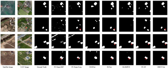
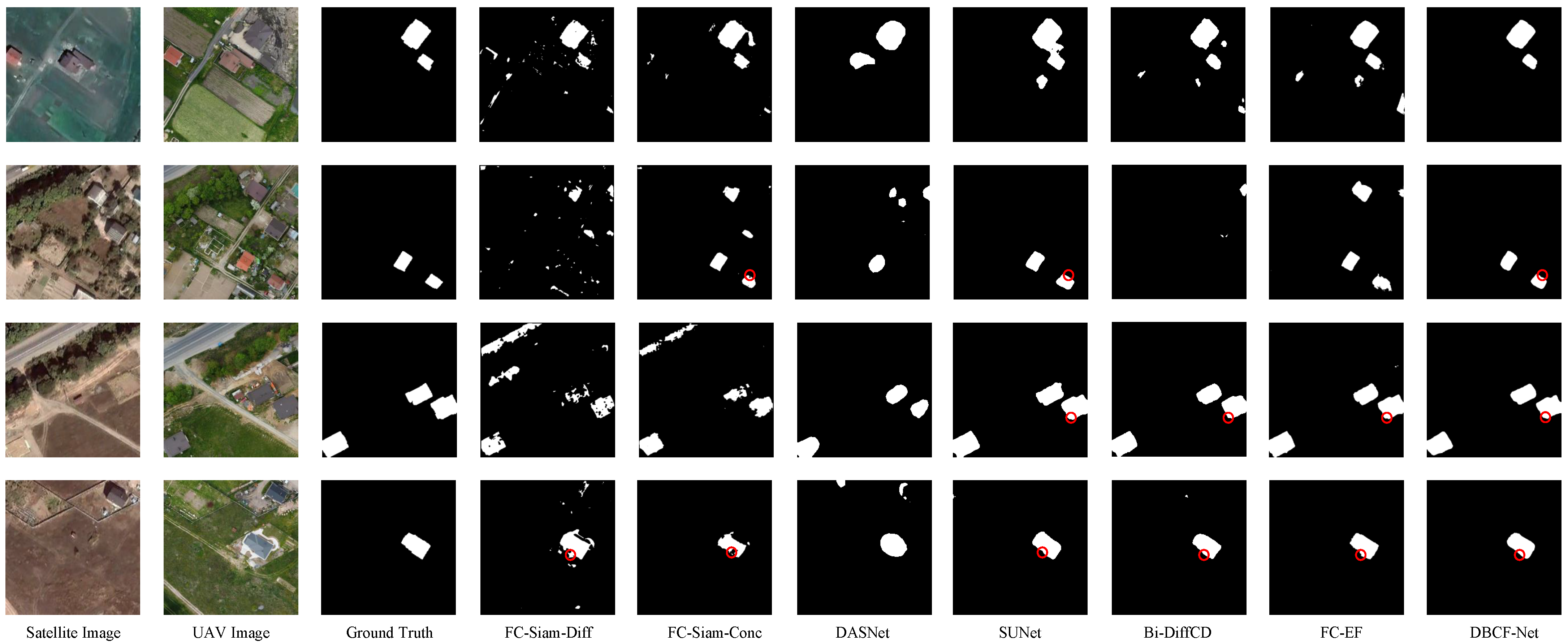
Figure 4 presents a visual comparison of the change detection results on representative test samples. The figure displays the input Satellite (T1) and UAV (T2) images, the Ground Truth, and the prediction maps generated by different methods.
Figure 4.
Visual comparisons of change detection results on the test set of the HSUD dataset. The columns from left to right represent: Satellite Image, UAV Image, Ground Truth, FC-Siam-Diff, FC-Siam-Conc, DASNet, SUNet, Bi-DiffCD, FC-EF, and DBCF-Net. The red circles highlight challenging regions characterized by complex boundaries or small objects.
Early CNN-based Methods: Early CNN-based methods, specifically FC-Siam-Diff, FC-Siam-Conc, and FC-EF, exhibit significant limitations in heterogeneous scenarios. As observed in the visual results, these models produce prediction maps characterized by substantial noise and fragmented regions.
- FC-Siam-Diff relies on pixel-wise differencing, which mathematically fails to account for the radiometric shift between satellite and UAV sensors, leading to a catastrophic failure in detecting valid changes (IoU of only 0.3741).
- FC-Siam-Conc improves upon the difference-based approach by utilizing feature concatenation, which preserves more information and achieves an IoU of 0.4920. However, it still suffers from significant noise and fails to effectively model the non-linear relationship between the heterogeneous modalities.
- FC-EF performs relatively better by utilizing early fusion (concatenating raw images), achieving the second-best quantitative performance among the baseline CNNs with an IoU of 0.7371. However, visually, it still struggles to delineate sharp boundaries and frequently generates false positives due to its inability to explicitly model the complex non-linear relationships and scale variations inherent in heterogeneous modalities.
Methods Incorporating Attention Mechanisms: While methods like DASNet and SUNet introduce attention mechanisms, they still suffer from missed detections and discontinuous regions in the complex scenes shown in Figure 4. For example, in the second and fourth rows, some small change regions are not fully identified. This indicates that while these methods attempt to capture long-range dependencies, they remain insufficient in cross-scale feature alignment and distinguishing subtle changes, especially in complex scenarios. This is reflected in their quantitative scores (DASNet: IoU 0.6401; SUNet: IoU 0.6947), which are noticeably lower than FC-EF, highlighting that standard attention mechanisms may not suffice for the extreme domain gaps in heterogeneous data.
Generative Model-based Methods: Bi-DiffCD, representing generative Diffusion models, performs well in suppressing background noise, yet its prediction maps show slightly blurred boundaries for small objects. For instance, the edges of some minute change regions appear less sharp and precise. This can be attributed to the stochastic nature of its diffusion generation process and potential smoothing of high-frequency details during denoising, which consequently impacts its IoU (0.7148). In disaster scenarios, blurred boundaries can lead to misjudgments of damage extent, affecting the accuracy of subsequent assessments.
Superiority of DBCF-Net: In contrast, our proposed DBCF-Net is visually the closest to the Ground Truth. Its prediction maps not only exhibit a clean background with virtually no fragmented noise but also accurately capture small change objects, while preserving sharp boundaries and structural integrity. Particularly in the complex regions highlighted by red circles, DBCF-Net provides more precise and coherent change areas.
This exceptional visual performance is primarily attributed to:
- DAAM Module: By explicitly aligning cross-modal features and suppressing radiometric pseudo-changes, DAAM effectively handles the complexity of heterogeneous data, enabling the network to extract purer change signals from noise.
- AGFM Module: Its adaptive fusion of semantic and spatial details effectively mitigates the “mixed pixel” effect, ensuring that fine-grained spatial fidelity is retained during multi-scale feature fusion, thereby achieving high-precision boundary identification.
To further investigate how DBCF-Net mitigates the specific challenges of heterogeneous data (i.e., extreme scale variation and geometric distortion), we conducted a qualitative analysis of the visual results in Figure 4. First, the extreme scale variation (8-fold resolution gap) is manifested as blurred boundaries, fragmented segments, and missed small objects in baseline models (e.g., FC-Siam-Diff and DASNet), as they struggle to align the coarse satellite pixels with fine UAV textures. In contrast, as shown in the first and third rows of Figure 4, DBCF-Net produces much sharper and continuous building contours. Furthermore, in the second row, DBCF-Net accurately extracts the small target (highlighted by the red circle) that is entirely missed by DASNet. This confirms that the AGFM module effectively aggregates high-frequency spatial details from the UAV branch to compensate for the satellite’s spectral blur. Second, geometric distortions and radiometric shifts frequently lead to false positives in homogeneous-oriented models. For instance, in the fourth row (highlighted by the red circle), baseline methods such as FC-Siam-Diff and SUNet are misled by imaging artifacts, resulting in distorted edges. Our model, however, exhibits superior noise suppression in these challenging regions, demonstrating that the DAAM module successfully utilizes difference-aware attention to distinguish genuine semantic changes from pseudo-changes. These visual improvements directly substantiate that the proposed architecture explicitly addresses the heterogeneous bottlenecks identified in the Introduction, rather than merely achieving higher numerical accuracy.
Practical Application Value: DBCF-Net’s outstanding visual performance, especially regarding boundary sharpness and structural integrity, is critical for time-sensitive disaster scenarios. Clear, unfragmented change maps provide more reliable damage information for decision-makers, effectively preventing assessment deviations caused by ambiguity or omissions, thereby supporting more efficient and precise deployment of rescue efforts and reconstruction planning.
3.2.4. Parameter Sensitivity Analysis
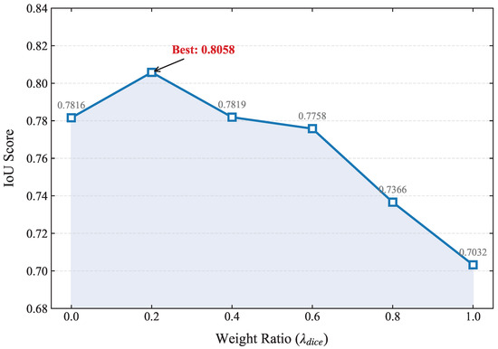
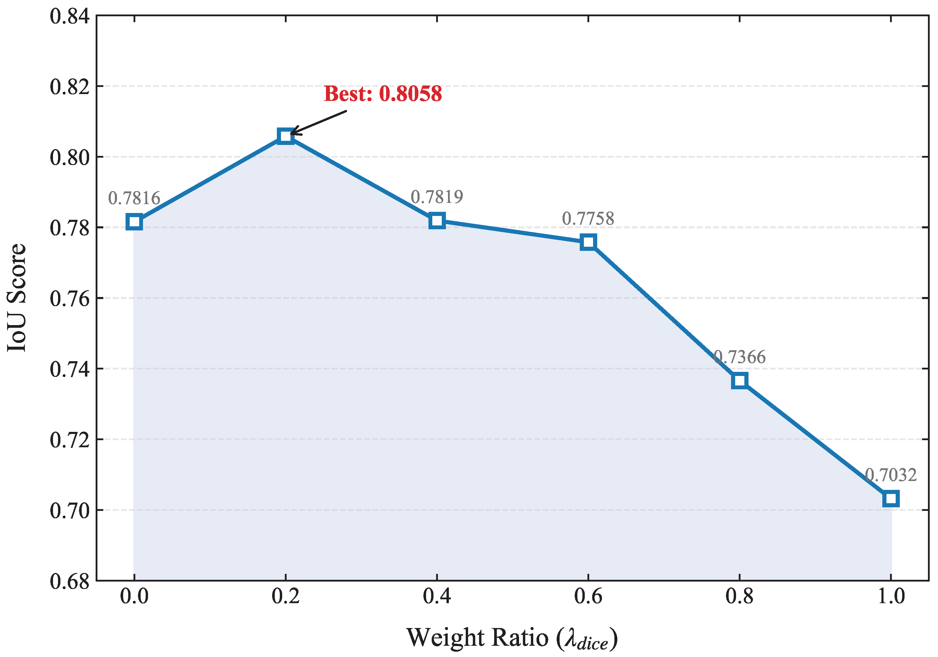
To investigate the impact of the loss function hyperparameters on the model performance, we conducted a sensitivity analysis on the weights of the hybrid loss function. As defined in (10), the total loss is a weighted sum of Cross-Entropy loss and Dice loss: , where .
We varied from 0.0 to 1.0 with a step size of 0.2, and the corresponding was adjusted accordingly. The variations in IoU on the HSUD test set are visualized in Figure 5.
Figure 5.
Performance trend with different weight ratios of . The IoU peak at , indicating the optimal balance between pixel-wise classification and region-based overlap optimization.
As observed in Figure 5, the model achieves suboptimal performance when trained with only Cross-Entropy loss () or only Dice loss (). Pure Cross-Entropy loss tends to focus on pixel-level accuracy but may ignore the structural consistency of change regions, while pure Dice loss can be unstable during the early stages of training. The performance improves as the two losses are combined, peaking at the ratio of and . This indicates that assigning a higher weight to the pixel-wise classification (CE) while incorporating region-based guidance (Dice) provides the most robust supervision for heterogeneous change detection tasks.
3.2.5. Computational Complexity Analysis
To quantitatively evaluate the computational efficiency of the proposed DBCF-Net, we compared its parameters (Params) and floating-point operations (FLOPs) with several baseline methods. The results are summarized in Table 3.
Table 3.
Computational complexity comparison. Params (M) denotes millions of parameters, and FLOPs (G) denotes giga-floating point operations.
As shown in Table 3, DBCF-Net achieves an exceptional balance between performance and computational overhead. Despite utilizing a dual-branch architecture, its FLOPs (8.358G) are significantly lower than other advanced models, being only 19.2% of SUNet (43.373G) and 8.3% of DASNet (100.723G). Notably, DBCF-Net even requires fewer FLOPs than the generative model Bi-DiffCD (10.547G). Given that Bi-DiffCD further necessitates multiple iterative sampling steps, our single-pass feed-forward architecture offers an overwhelming advantage in inference speed. This efficiency, combined with high segmentation accuracy, makes DBCF-Net highly suitable for rapid post-disaster situational awareness.
4. Discussion
4.1. Analysis of Heterogeneous Challenges
The experimental results presented in the previous section clearly highlight the unique challenges posed by heterogeneous satellite–UAV change detection. A critical observation is the performance gap between FC-Siam-Diff (IoU 37.41%) and FC-EF (IoU 73.71%).
In homogeneous scenarios, the difference operation is standard. However, in heterogeneous scenarios, satellite and UAV images possess distinct spectral response functions. Consequently, a zero difference in feature space does not strictly correspond to no semantic change; rather, direct subtraction often amplifies domain shift noise.
Interestingly, FC-EF outperforms both Siamese baselines and attention-based networks by accessing raw concatenated inputs, implicitly learning non-linear mappings. However, as noted in Section 3.2.3, without explicit multi-scale handling, it results in the over-smoothed boundaries. Furthermore, while the diffusion-based Bi-DiffCD implicitly aligns distributions, it falls short of DBCF-Net (IoU 0.7148 vs. 0.8058). We attribute this to Bi-DiffCD optimizing for global distribution alignment—an indirect objective that may sacrifice local structural fidelity to satisfy statistical consistency. In contrast, our DAAM module is directly supervised to maximize the discriminability of the difference map for segmentation, ensuring that the feature recalibration is strictly driven by semantic changes rather than generative hallucinations.
4.2. Interpretation of the Proposed Method
Our DBCF-Net addresses these issues through a divide-and-conquer strategy:
Role of DAAM: Noise Suppression. The Difference-Aware Attention Module (DAAM) filters out pseudo-changes caused by spectral shifts. As analyzed in Section 3.2.2, DAAM significantly boosts Recall by focusing attention only on regions with significant semantic discrepancies rather than global radiometric differences.
Role of AGFM: Detail Preservation. The Adaptive Gated Fusion Module (AGFM) targets the resolution gap ( vs. ). By dynamically weighting contributions via the similarity map S, it ensures high-frequency details from the UAV branch are not washed out. This explains the high Precision observed in the ablation study.
Synergistic Effect. The combination of DAAM and AGFM yields the optimal result. DAAM creates a “clean” feature representation by removing spectral noise, allowing AGFM to confidently fuse fine-grained details without integrating artifacts.
The design of DAAM aligns with the physical reality that heterogeneous sensors respond differently to the same land-cover material. By utilizing the discrepancy map as a spatial prompt, the network learns to distinguish between radiometric fluctuations (caused by sun angle or atmospheric conditions) and structural transformations (caused by actual land-use change). Furthermore, the AGFM’s gating mechanism effectively addresses the point spread function (PSF) mismatch between satellite and UAV optics, ensuring that the upsampled coarse pixels do not blur the high-resolution object boundaries.
4.3. Limitations and Future Work
Despite promising results, limitations exist. First, the pseudo-Siamese structure with two independent ResNet-34 backbones increases parameters compared to weight-sharing networks. Future work will explore lightweight backbones or knowledge distillation to evaluate the true FPS on edge-computing devices like NVIDIA Jetson. Second, the HSUD dataset is relatively small. We plan to expand the dataset to cover more diverse scenes to validate generalization capability further.
Third, regarding feature alignment supervision, the current DBCF-Net relies solely on the final hybrid segmentation loss (Cross-Entropy and Dice) for backpropagation. While this end-to-end optimization maintains architectural simplicity and allows DAAM to function effectively as an implicit ’soft aligner’, it provides relatively weak supervision for explicitly constraining the deep feature spaces of the distinct branches. Exploring explicit auxiliary alignment objectives, such as cross-modal Contrastive Loss or Maximum Mean Discrepancy (MMD), to directly constrain and pull the heterogeneous feature distributions closer during the early extraction stages represents a highly promising direction for our future research.
5. Conclusions
In this paper, we have addressed the challenging problem of heterogeneous change detection between historical satellite imagery and post-event UAV imagery. To overcome the inherent difficulties caused by significant resolution differences and spectral domain shifts, we proposed a novel Dual-Branch Cross-Scale Fusion Network (DBCF-Net). Unlike traditional weight-sharing Siamese networks, our approach employs a pseudo-Siamese architecture to respect the distinct characteristics of each modality.
Specifically, we introduced the Difference-Aware Attention Module (DAAM), which explicitly models the cross-modal discrepancy and utilizes a hybrid attention mechanism to suppress pseudo-changes arising from radiometric inconsistencies. Furthermore, we designed the Adaptive Gated Fusion Module (AGFM) to dynamically weight and fuse multi-scale features, ensuring that fine-grained spatial details from UAV images are effectively preserved in the final change map.
Extensive experiments on our self-constructed Heterogeneous Satellite–UAV Dataset (HSUD) demonstrated that DBCF-Net achieves state-of-the-art performance. With an F1-score of 88.75% and an IoU of 80.58%, our method significantly outperforms existing baseline models, proving its robustness in complex scenarios involving scale variations and shadow occlusions.
In future work, we aim to focus on two main directions: (1) developing lightweight backbone networks to reduce computational complexity for on-board UAV processing, enabling low-latency edge computing for emergency situations; and (2) expanding the dataset to cover diverse land-cover types. Ultimately, we hope to integrate DBCF-Net into operational environmental monitoring systems, contributing to more resilient and sustainable disaster management strategies.
Author Contributions
Conceptualization, Y.R. and R.L.; methodology, Y.R. and R.L.; software, Y.R., R.L. and P.Z.; validation, Y.R., R.L. and P.Z.; formal analysis, Y.R. and R.L.; data curation, R.L. and P.Z.; writing—original draft preparation, R.L.; writing—review and editing, Y.R. and X.C.; supervision, Y.R. and X.C.; project administration, Y.R. All authors have read and agreed to the published version of the manuscript.
Funding
The first author is supported by the Fundamental Research Funds for the Universities of Liaoning Province (Grant No.: LJ212410143046) and Joint Program of Liaoning Provincial Science and Technology Plan (Grant No.: 2025-MSLH-555).
Data Availability Statement
The data presented in this study are not publicly available due to privacy and/or research management restrictions.
Conflicts of Interest
The authors declare no conflicts of interest.
Abbreviations
The following abbreviations are used in this manuscript:
| CD | Change Detection |
| UAV | Unmanned Aerial Vehicle |
| CNN | Convolutional Neural Network |
| DBCF-Net | Dual-Branch Cross-Scale Fusion Network |
| DAAM | Difference-Aware Attention Module |
| AGFM | Adaptive Gated Fusion Module |
| IoU | Intersection over Union |
| OA | Overall Accuracy |
| SDG | Sustainable Development Goal |
References
- Zhao, Q.; Yu, L. Advancing Sustainable Development Goals through Earth Observation Satellite Data: Current Insights and Future Directions. J. Remote Sens. 2025, 5, 0403. [Google Scholar] [CrossRef] [Scilit]
- Lartey, D.; Law, K.M.Y. Artificial intelligence adoption in urban planning governance: A systematic review of advancements in decision-making, and policy making. Landsc. Urban Plan. 2025, 258, 105337. [Google Scholar] [CrossRef] [Scilit]
- Bhardwaj, D.; Nagabhooshanam, N.; Singh, A.; Selvalakshmi, B.; Angadi, S.; Shargunam, S.; Guha, T.; Singh, G.; Rajaram, A. Enhanced satellite imagery analysis for post-disaster building damage assessment using integrated ResNet-U-Net model. Multimed. Tools Appl. 2025, 84, 2689–2714. [Google Scholar] [CrossRef] [Scilit]
- Nguyen, K.A.; Huang, C.-S.; Chen, W. Machine Learning-Based Land Cover Mapping of Nanfeng Village with Emphasis on Landslide Detection. Sustainability 2025, 17, 8250. [Google Scholar] [CrossRef] [Scilit]
- Bai, T.; Wang, L.; Yin, D.; Sun, K.; Chen, Y.; Li, W.; Li, D. Deep learning for change detection in remote sensing: A review. Geo-Spat. Inf. Sci. 2023, 26, 262–288. [Google Scholar] [CrossRef] [Scilit]
- Cáceres Tovar, O.A.; Cleves-Leguízamo, J.A.; González Angarita, G.P. Advanced Machine Learning Methods as a Planning Strategy in the Capellanía Wetland. Sustainability 2025, 17, 8462. [Google Scholar] [CrossRef] [Scilit]
- Khelifi, L.; Mignotte, M. Deep learning for change detection in remote sensing images: Comprehensive review and meta-analysis. IEEE Access 2020, 8, 126385–126400. [Google Scholar] [CrossRef] [Scilit]
- Zhu, X.X.; Tuia, D.; Mou, L.; Xia, G.-S.; Zhang, L.; Xu, F.; Fraundorfer, F. Deep learning in remote sensing: A comprehensive review and list of resources. IEEE Geosci. Remote Sens. Mag. 2017, 5, 8–36. [Google Scholar] [CrossRef] [Scilit]
- Ma, L.; Liu, Y.; Zhang, X.; Ye, Y.; Yin, G.; Johnson, B.A. Deep learning in remote sensing applications: A meta-analysis and review. ISPRS J. Photogramm. Remote Sens. 2019, 152, 166–177. [Google Scholar] [CrossRef] [Scilit]
- Malila, W.A. Change vector analysis: An approach for detecting forest changes with Landsat. In Proceedings of the LARS Symposia, West Lafayette, IN, USA, 3–6 June 1980; p. 385. [Google Scholar]
- Deng, J.S.; Wang, K.; Deng, Y.H.; Qi, G.J. PCA-based land-use change detection and analysis using multitemporal and multisensor satellite data. Int. J. Remote Sens. 2008, 29, 4823–4838. [Google Scholar] [CrossRef] [Scilit]
- Nielsen, A.A.; Conradsen, K.; Simpson, J.J. Multivariate Alteration Detection (MAD) and MAF Postprocessing in Multispectral, Bitemporal Image Data: New Approaches to Change Detection Studies. Remote Sens. Environ. 1998, 64, 1–19. [Google Scholar] [CrossRef] [Scilit]
- Mou, L.; Bruzzone, L.; Zhu, X.X. Learning spectral-spatial-temporal features via a recurrent convolutional neural network for change detection in multispectral imagery. IEEE Trans. Geosci. Remote Sens. 2018, 57, 924–935. [Google Scholar] [CrossRef] [Scilit]
- Zhang, C.; Yue, P.; Tapete, D.; Jiang, L.; Shangguan, B.; Huang, L.; Liu, G. A deeply supervised image fusion network for change detection in high resolution bi-temporal remote sensing images. ISPRS J. Photogramm. Remote Sens. 2020, 166, 183–200. [Google Scholar] [CrossRef] [Scilit]
- Daudt, R.C.; Le Saux, B.; Boulch, A. Fully convolutional siamese networks for change detection. In Proceedings of the 2018 25th IEEE International Conference on Image Processing (ICIP), Athens, Greece, 7–10 October 2018; pp. 4063–4067. [Google Scholar]
- Chen, J.; Yuan, Z.; Peng, J.; Chen, L.; Huang, H.; Zhu, J.; Liu, Y.; Li, H. DASNet: Dual attentive fully convolutional Siamese networks for change detection in high-resolution satellite images. IEEE J. Sel. Top. Appl. Earth Obs. Remote Sens. 2020, 14, 1194–1206. [Google Scholar] [CrossRef] [Scilit]
- Chen, H.; Shi, Z. A spatial-temporal attention-based method and a new dataset for remote sensing image change detection. Remote Sens. 2020, 12, 1662. [Google Scholar] [CrossRef] [Scilit]
- Wang, D.; Chen, X.; Jiang, M.; Du, S.; Xu, B.; Wang, J. ADS-Net: An Attention-Based deeply supervised network for remote sensing image change detection. Int. J. Appl. Earth Obs. Geoinf. 2021, 101, 102348. [Google Scholar]
- Chen, H.; Qi, Z.; Shi, Z. Remote sensing image change detection with transformers. IEEE Trans. Geosci. Remote Sens. 2021, 60, 5607514. [Google Scholar] [CrossRef] [Scilit]
- Bandara, W.G.C.; Patel, V.M. A transformer-based siamese network for change detection. In Proceedings of the IGARSS 2022—2022 IEEE International Geoscience and Remote Sensing Symposium, Kuala Lumpur, Malaysia, 17–22 July 2022; pp. 207–210. [Google Scholar]
- Zhang, C.; Wang, L.; Cheng, S.; Li, Y. SwinSUNet: Pure transformer network for remote sensing image change detection. IEEE Trans. Geosci. Remote Sens. 2022, 60, 5224713. [Google Scholar] [CrossRef] [Scilit]
- Chen, H.; Song, J.; Han, C.; Xia, J.; Yokoya, N. ChangeMamba: Remote sensing change detection with spatiotemporal state space model. IEEE Trans. Geosci. Remote Sens. 2024, 62, 4409720. [Google Scholar] [CrossRef] [Scilit]
- Wen, Y.; Zhang, Z.; Cao, Q.; Niu, G. Transc-gd-cd: Transformer-based conditional generative diffusion change detection model. IEEE J. Sel. Top. Appl. Earth Obs. Remote Sens. 2024, 17, 7144–7158. [Google Scholar] [CrossRef] [Scilit]
- Liu, F.; Wen, Y.; Sun, J.; Zhu, P.; Mao, L.; Niu, G.; Li, J. Iterative Mamba Diffusion Change-Detection Model for Remote Sensing. Remote Sens. 2024, 16, 3651. [Google Scholar] [CrossRef] [Scilit]
- Peng, X.; Zhong, R.; Li, Z.; Li, Q. Optical Remote Sensing Image Change Detection Based on Attention Mechanism and Image Difference. IEEE Trans. Geosci. Remote Sens. 2021, 59, 7296–7307. [Google Scholar] [CrossRef] [Scilit]
- Yao, H.; Qin, R.; Chen, X. Unmanned aerial vehicle for remote sensing applications—A review. Remote Sens. 2019, 11, 1443. [Google Scholar] [CrossRef] [Scilit]
- Wang, F.; Dai, X.; He, G.; Wang, J. Building change detection from satellite and UAV heterogeneous remote sensing images: From benchmark dataset to methodological application. Int. J. Remote Sens. 2025, 46, 9434–9465. [Google Scholar] [CrossRef] [Scilit]
- Yu, J.; Chen, Y.; Li, S.; Zhang, H.; Chen, Y. Secondary matching algorithm: A new heterogeneous image matching algorithm for the uav image and satellite remote sensing image. In Proceedings of the IGARSS 2022—2022 IEEE International Geoscience and Remote Sensing Symposium, Kuala Lumpur, Malaysia, 17–22 July 2022; pp. 3275–3278. [Google Scholar]
- Shao, R.; Du, C.; Chen, H.; Li, J. SUNet: Change detection for heterogeneous remote sensing images from satellite and UAV using a dual-channel fully convolution network. Remote Sens. 2021, 13, 3750. [Google Scholar] [CrossRef] [Scilit]
- Ning, L.; Zhou, Q.; Wang, Q.; Gao, J.; Li, X. Cross-resolution change detection in remote sensing via unequal relationships from a frequency perspective. IEEE Trans. Geosci. Remote Sens. 2025, 63, 4414514. [Google Scholar] [CrossRef] [Scilit]
- Chen, H.; Zhang, H.; Chen, K.; Zhou, C.; Chen, S.; Zou, Z.; Shi, Z. Continuous cross-resolution remote sensing image change detection. IEEE Trans. Geosci. Remote Sens. 2023, 61, 5623320. [Google Scholar] [CrossRef] [Scilit]
- Lv, Z.; Cheng, S.; Xie, L.; Li, J.; Zhao, M. A graph contrastive learning network for change detection with heterogeneous remote sensing images. Pattern Recognit. 2025, 172, 112394. [Google Scholar] [CrossRef] [Scilit]
- Touati, R.; Mignotte, M.; Dahmane, M. Multimodal change detection in remote sensing images using an unsupervised pixel pairwise-based Markov random field model. IEEE Trans. Image Process. 2019, 29, 757–767. [Google Scholar] [CrossRef] [Scilit]
- Durgam, A.; Paheding, S.; Dhiman, V.; Devabhaktuni, V. Cross-view geo-localization: A survey. IEEE Access 2024, 12, 11542–11565. [Google Scholar] [CrossRef] [Scilit]
- Zhao, J.; Qu, J.; Dong, W. Bi-DiffCD: Bidirectional Diffusion Guided Collaborative Change Detection for Arbitrary-Modal Remote Sensing Images. In Proceedings of the Thirty-Fourth International Joint Conference on Artificial Intelligence (IJCAI-25), Montreal, QC, Canada, 16–22 August 2025; pp. 2449–2457. [Google Scholar]
- Wang, J.-X.; Li, T.; Chen, S.-B.; Gu, C.-J.; You, Z.-H.; Luo, B. Diffusion Models and Pseudo-Change: A Transfer Learning-Based Change Detection in Remote Sensing Images. IEEE Trans. Geosci. Remote Sens. 2024, 62, 4415613. [Google Scholar] [CrossRef] [Scilit]
- Zhu, J.-Y.; Park, T.; Isola, P.; Efros, A.A. Unpaired image-to-image translation using cycle-consistent adversarial networks. In Proceedings of the IEEE International Conference on Computer Vision (ICCV), Venice, Italy, 22–29 October 2017; pp. 2223–2232. [Google Scholar]
- Niu, X.; Gong, M.; Zhan, T.; Yang, Y. A conditional adversarial network for change detection in heterogeneous images. IEEE Geosci. Remote Sens. Lett. 2018, 16, 45–49. [Google Scholar] [CrossRef] [Scilit]
- Liu, J.; Gong, M.; Qin, K.; Zhang, P. A deep convolutional coupling network for change detection based on heterogeneous optical and radar images. IEEE Trans. Neural Netw. Learn. Syst. 2016, 29, 545–559. [Google Scholar] [CrossRef] [Scilit]
- Li, X.; Yan, L.; Zhang, Y.; Zeng, H. ESR-DMNet: Enhanced super-resolution-based dual-path metric change detection network for remote sensing images with different resolutions. IEEE Trans. Geosci. Remote Sens. 2024, 62, 5402415. [Google Scholar] [CrossRef] [Scilit]
- Yuan, W.; Yuan, X.; Fan, Z.; Guo, Z.; Shi, X.; Gong, J.; Shibasaki, R. Graph neural network based multi-feature fusion for building change detection. Int. Arch. Photogramm. Remote Sens. Spat. Inf. Sci. 2021, 43, 377–382. [Google Scholar] [CrossRef] [Scilit]
- Wang, G.; Chen, H.; Qiao, T.; Wang, J.; Liu, W. Resolution-Difference Embedded Network for Cross-Resolution Remote Sensing Image Change Detection. IEEE Trans. Geosci. Remote Sens. 2025, 63, 5637721. [Google Scholar] [CrossRef] [Scilit]
- Wei, J.; Sun, K.; Li, W.; Li, W.; Gao, S.; Miao, S.; Tan, Y.; Cui, W.; Duan, Y. Cross-Visual Style Change Detection for Remote Sensing Images via Representation Consistency Deep Supervised Learning. Remote Sens. 2025, 17, 798. [Google Scholar] [CrossRef] [Scilit]
- Hu, J.; Shen, L.; Sun, G. Squeeze-and-excitation networks. In Proceedings of the IEEE Conference on Computer Vision and Pattern Recognition (CVPR), Salt Lake City, UT, USA, 18–22 June 2018; pp. 7132–7141. [Google Scholar]
- Woo, S.; Park, J.; Lee, J.-Y.; Kweon, I.S. CBAM: Convolutional Block Attention Module. In Proceedings of the European Conference on Computer Vision (ECCV), Munich, Germany, 8–14 September 2018; pp. 3–19. [Google Scholar]
- Li, X.; Wang, W.; Hu, X.; Yang, J. Selective kernel networks. In Proceedings of the IEEE/CVF Conference on Computer Vision and Pattern Recognition (CVPR), Long Beach, CA, USA, 16–20 June 2019; pp. 510–519. [Google Scholar]

Disclaimer/Publisher’s Note: The statements, opinions and data contained in all publications are solely those of the individual author(s) and contributor(s) and not of MDPI and/or the editor(s). MDPI and/or the editor(s) disclaim responsibility for any injury to people or property resulting from any ideas, methods, instructions or products referred to in the content. |
© 2026 by the authors. Licensee MDPI, Basel, Switzerland. This article is an open access article distributed under the terms and conditions of the Creative Commons Attribution (CC BY) license.