DBCF-Net: A Dual-Branch Cross-Scale Fusion Network for Heterogeneous Satellite–UAV Change Detection

Highlights
- A novel Dual-Branch Cross-Scale Fusion Network (DBCF-Net) is proposed, utilizing a pseudo-Siamese architecture to handle the distinct statistical distributions of heterogeneous satellite and UAV data.
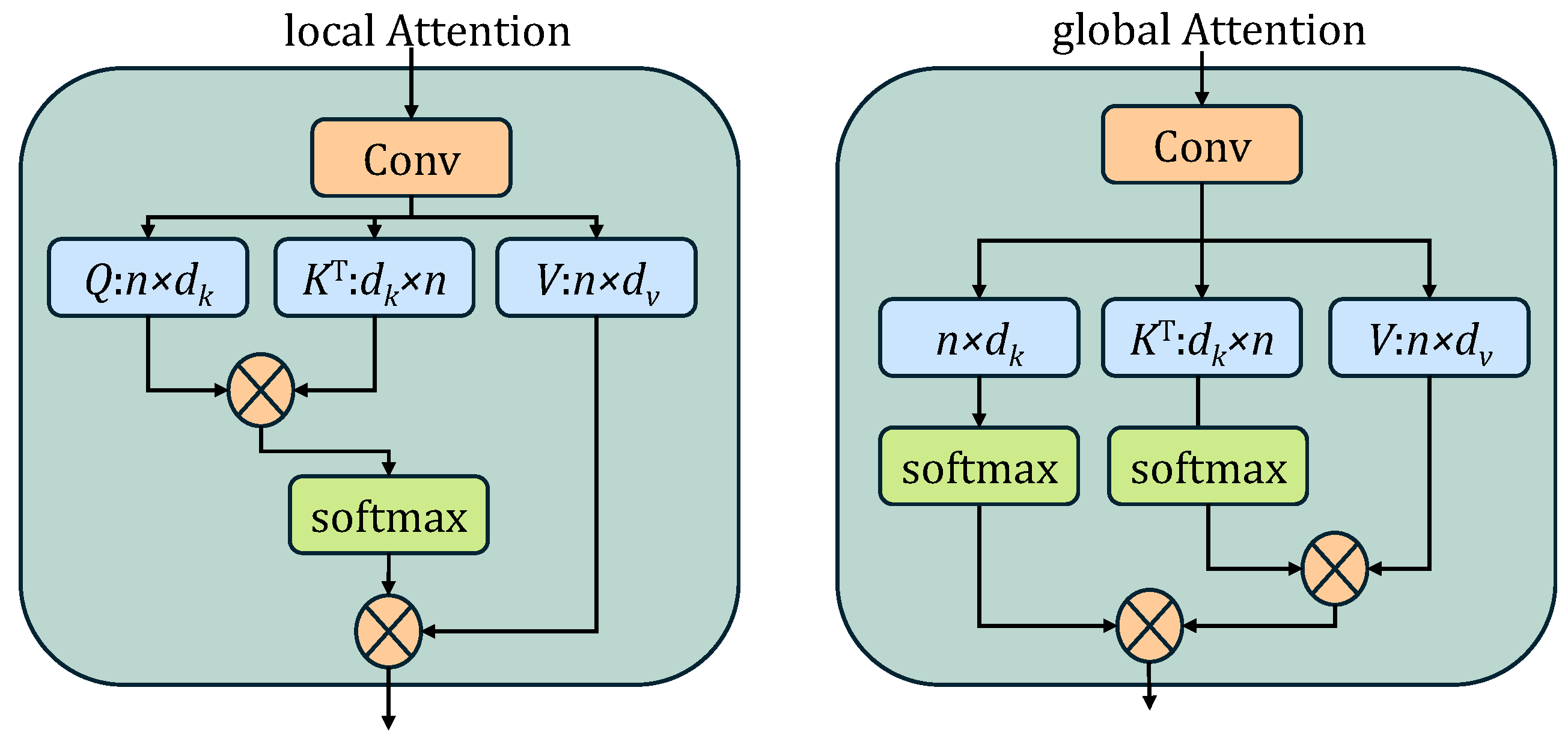
- The Difference-Aware Attention Module (DAAM) and the Adaptive Gated Fusion Module (AGFM) were developed to mitigate radiometric shifts and extreme resolution disparities.
- The model achieves superior boundary precision and noise suppression, significantly outperforming state-of-the-art methods on the HSUD dataset.
- With high inference efficiency, DBCF-Net provides a robust technical framework for real-time disaster response and sustainable urban monitoring.
Abstract
1. Introduction
1.1. Background and Motivation
1.2. Challenges in Heterogeneous Change Detection
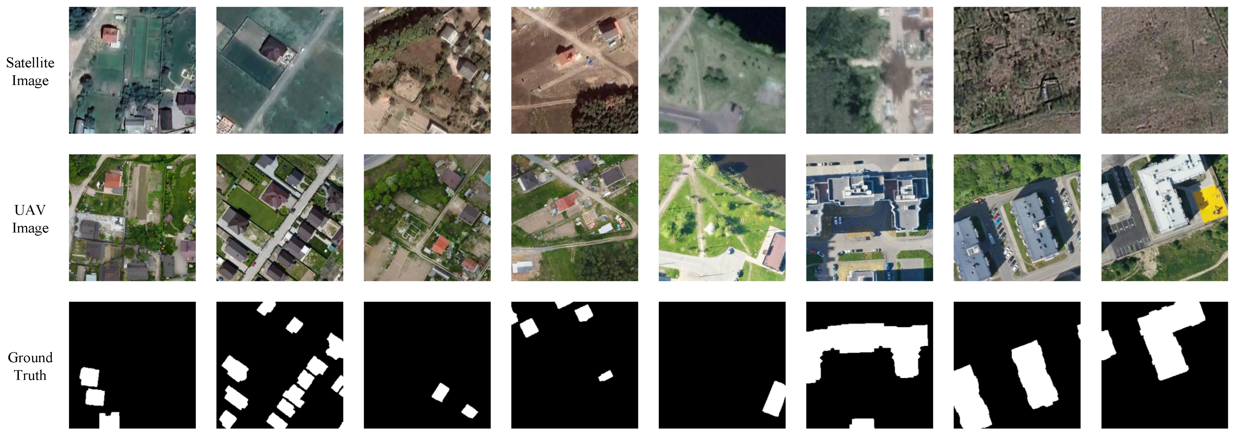
- Extreme Scale Variation: Satellite images typically have lower spatial resolutions (e.g., 0.5 m–10 m), whereas UAV images offer centimeter-level details (e.g., 2 cm–10 cm) [31]. This leads to the “mixed pixel” problem, where a single satellite pixel corresponds to complex textures in the UAV image, causing severe semantic ambiguity where the network struggles to distinguish true object boundaries from internal texture variations within the coarse satellite footprint. This discrepancy not only complicates feature alignment but also hinders the network from learning consistent semantic representations across views.
- Radiometric and Spectral Shift: Different sensors possess distinct spectral response functions. Coupled with varying atmospheric conditions and solar angles, this results in a significant domain shift [32]. Unchanged objects may exhibit drastically different colors and intensities, leading to widespread “pseudo-changes” that confound conventional distance-based metrics [33].
- Viewpoint and Geometric Distortion: UAVs often fly at lower altitudes with variable look angles, introducing relief displacement and occlusions compared to the nadir-view satellite imagery. These geometric disparities result in inevitable spatial misalignment. Consequently, standard pixel-to-pixel comparison methods (e.g., direct subtraction) become unreliable, necessitating a learning-based framework capable of establishing robust feature correspondences despite spatial shifts [34].
1.3. Contributions
- We collect and construct a novel Heterogeneous Satellite–UAV Dataset (HSUD), which serves as a primary contribution of this work. By providing rigorously registered image pairs with extreme spatial resolution gaps and radiometric shifts, HSUD addresses the scarcity of cross-platform benchmarks and provides a highly challenging, realistic evaluation platform for the remote sensing community.
- Framework: We propose DBCF-Net, a specialized framework for heterogeneous satellite–UAV change detection that effectively handles extreme resolution disparities, providing a robust tool for disaster response.
- Module (Alignment): We design DAAM to explicitly align cross-source features and suppress radiometric pseudo-changes.
- Module (Fusion): We introduce AGFM to progressively fuse multi-scale features, significantly improving boundary accuracy for precise damage assessment.
1.4. Related Work
1.4.1. Deep Learning for Homogeneous Change Detection
1.4.2. Heterogeneous Change Detection
1.4.3. Attention and Multi-Scale Fusion Mechanisms
2. Materials and Methods
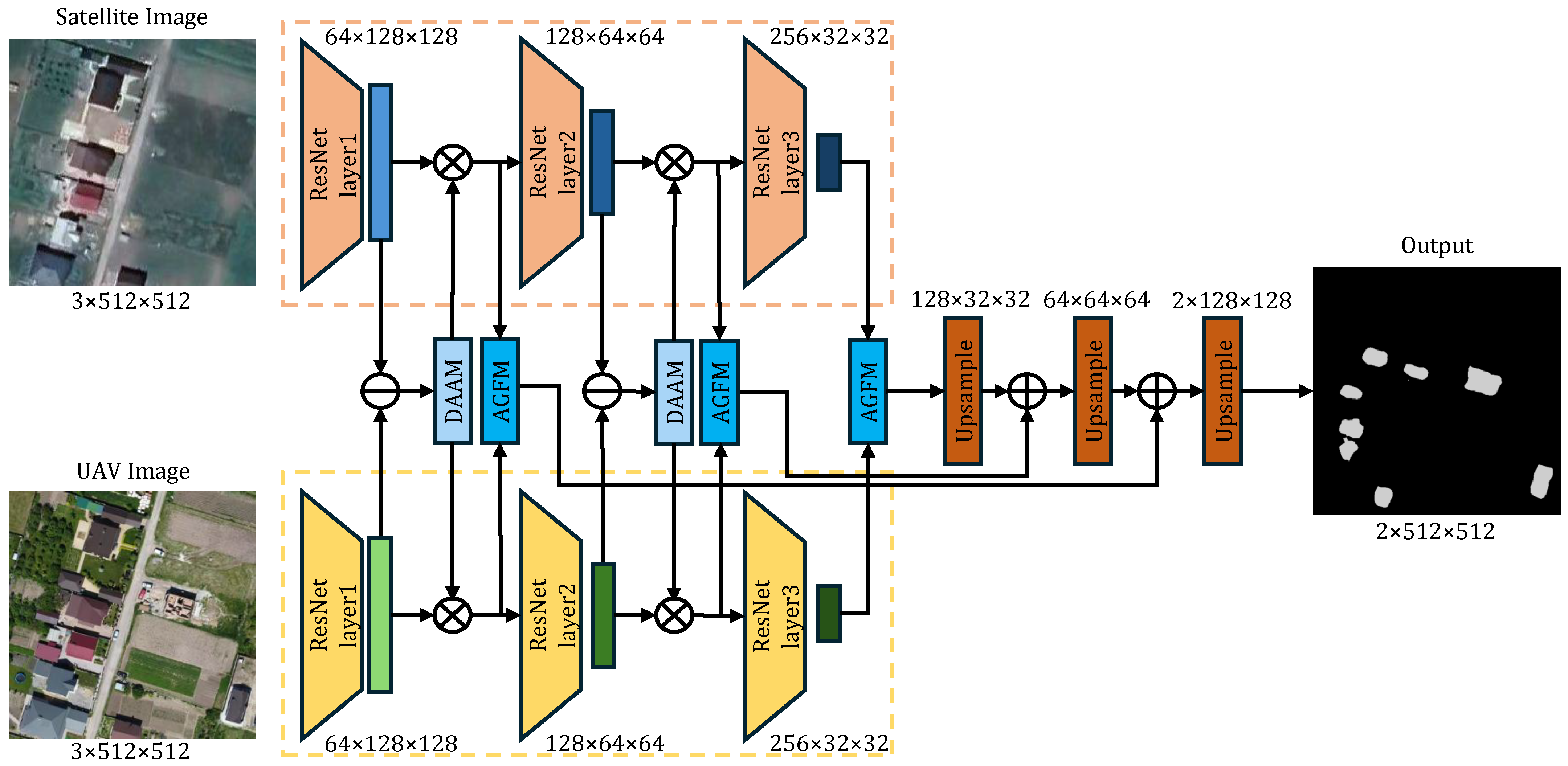
2.1. Overview of the Proposed Network
2.2. Feature Extraction Backbone: The Pseudo-Siamese Strategy
2.3. Difference-Aware Attention Module (DAAM)
2.3.1. Difference Feature Generation
2.3.2. Dual-Path Attention Mechanism
2.3.3. Feature Gating and Refinement
2.4. Adaptive Gated Fusion Module (AGFM)
2.5. Decoder and Hierarchical Aggregation
- Stage 1 (Deep Fusion): The deepest semantic features and are fused via AGFM to produce the initial coarse change map .
- Stage 2 (Intermediate Fusion): is upsampled and added to the fused features from the second stage (), generating . This step recovers mid-level structural information.
- Stage 3 (Shallow Fusion): Finally, is combined with the high-resolution features from the first stage ().
3. Results
3.1. Experiment Design
3.1.1. Datasets
3.1.2. Implementation Details
3.1.3. Training Settings
3.1.4. Loss Function
3.1.5. Comparison with Other Methods
- FC-EF, FC-Siam-Diff, and FC-Siam-Conc [15]: These are the baseline fully convolutional Siamese networks for change detection, representing early fusion, difference-based, and concatenation-based strategies, respectively.
- DASNet [16]: A dual-attentive fully convolutional Siamese network that employs a dual-attention mechanism to capture long-range dependencies and suppress pseudo-changes.
- SUNet [29]: A Siamese U-Net based architecture that combines Siamese networks with U-Net connections for robust multi-scale feature extraction in changing environments.
- Bi-DiffCD [35]: The latest diffusion-based generative method designed for arbitrary-modal change detection. It utilizes a bidirectional diffusion process to bridge the domain gap between heterogeneous images, representing the current state-of-the-art in this field.
3.1.6. Evaluation Metrics
3.2. Experiment
3.2.1. Quantitative Comparison with State-of-the-Art Methods
3.2.2. Ablation Study Results
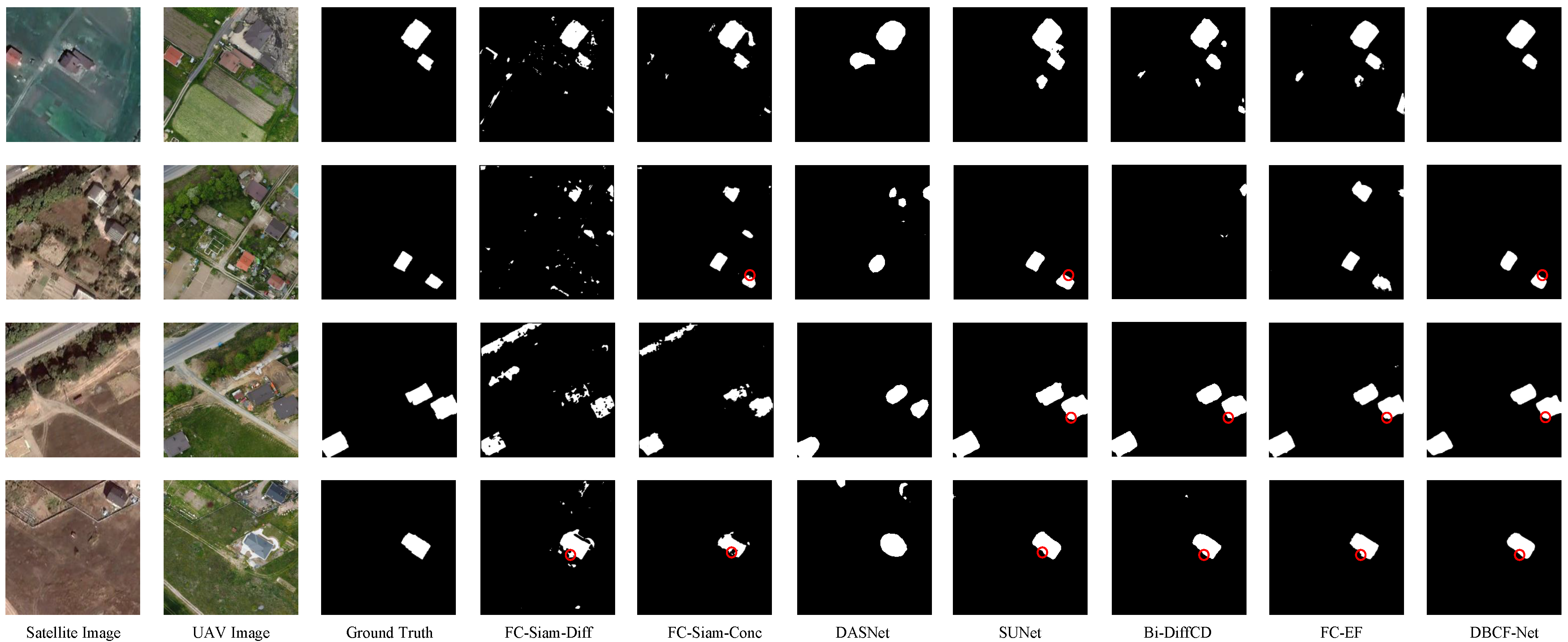
3.2.3. Visual Analysis Results
- FC-Siam-Diff relies on pixel-wise differencing, which mathematically fails to account for the radiometric shift between satellite and UAV sensors, leading to a catastrophic failure in detecting valid changes (IoU of only 0.3741).
- FC-Siam-Conc improves upon the difference-based approach by utilizing feature concatenation, which preserves more information and achieves an IoU of 0.4920. However, it still suffers from significant noise and fails to effectively model the non-linear relationship between the heterogeneous modalities.
- FC-EF performs relatively better by utilizing early fusion (concatenating raw images), achieving the second-best quantitative performance among the baseline CNNs with an IoU of 0.7371. However, visually, it still struggles to delineate sharp boundaries and frequently generates false positives due to its inability to explicitly model the complex non-linear relationships and scale variations inherent in heterogeneous modalities.
- DAAM Module: By explicitly aligning cross-modal features and suppressing radiometric pseudo-changes, DAAM effectively handles the complexity of heterogeneous data, enabling the network to extract purer change signals from noise.
- AGFM Module: Its adaptive fusion of semantic and spatial details effectively mitigates the “mixed pixel” effect, ensuring that fine-grained spatial fidelity is retained during multi-scale feature fusion, thereby achieving high-precision boundary identification.
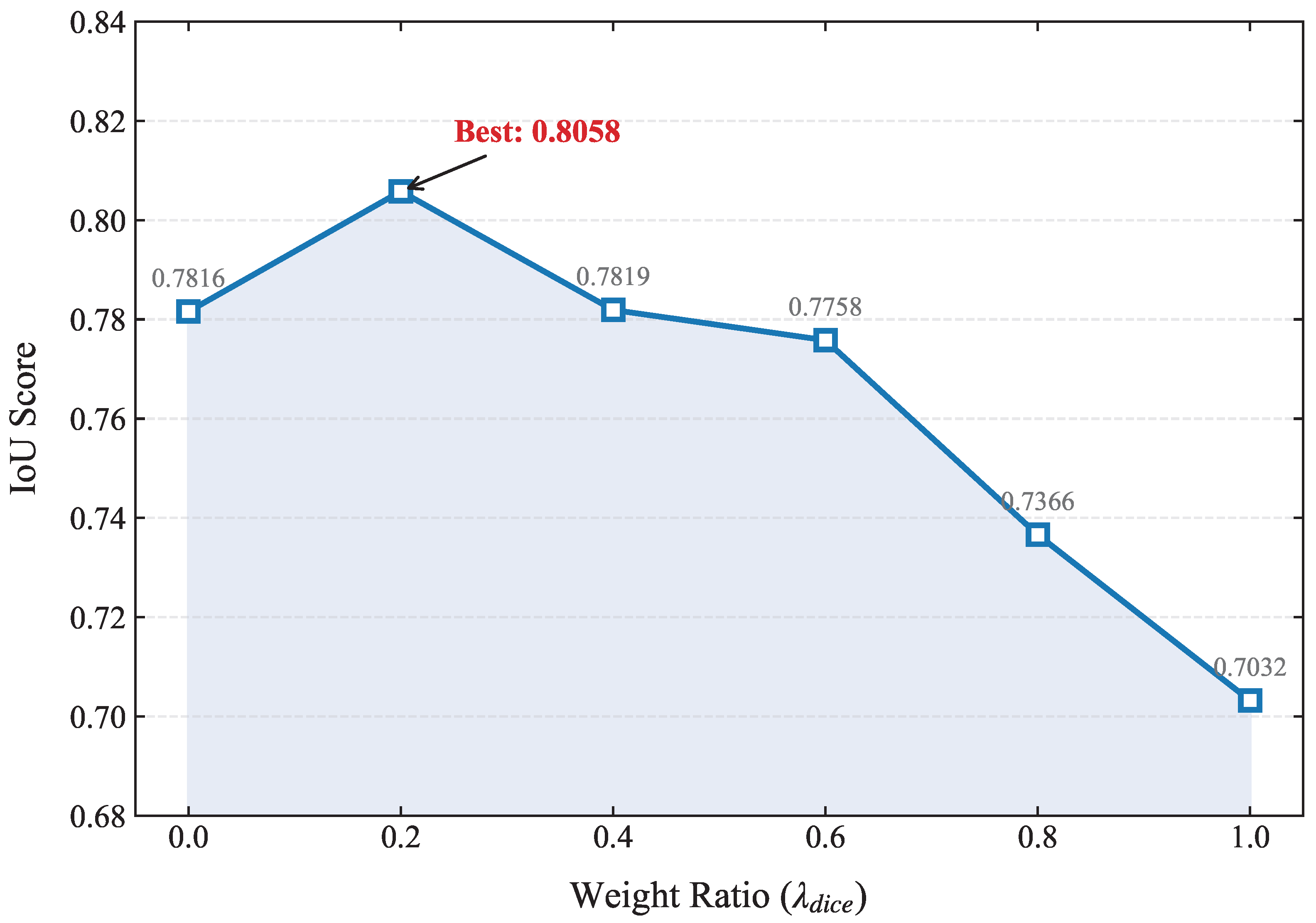
3.2.4. Parameter Sensitivity Analysis
3.2.5. Computational Complexity Analysis
4. Discussion
4.1. Analysis of Heterogeneous Challenges
4.2. Interpretation of the Proposed Method
4.3. Limitations and Future Work
5. Conclusions
Author Contributions
Funding
Data Availability Statement
Conflicts of Interest
Abbreviations
| CD | Change Detection |
| UAV | Unmanned Aerial Vehicle |
| CNN | Convolutional Neural Network |
| DBCF-Net | Dual-Branch Cross-Scale Fusion Network |
| DAAM | Difference-Aware Attention Module |
| AGFM | Adaptive Gated Fusion Module |
| IoU | Intersection over Union |
| OA | Overall Accuracy |
| SDG | Sustainable Development Goal |
References
- Zhao, Q.; Yu, L. Advancing Sustainable Development Goals through Earth Observation Satellite Data: Current Insights and Future Directions. J. Remote Sens. 2025, 5, 0403. [Google Scholar] [CrossRef] [Scilit]
- Lartey, D.; Law, K.M.Y. Artificial intelligence adoption in urban planning governance: A systematic review of advancements in decision-making, and policy making. Landsc. Urban Plan. 2025, 258, 105337. [Google Scholar] [CrossRef] [Scilit]
- Bhardwaj, D.; Nagabhooshanam, N.; Singh, A.; Selvalakshmi, B.; Angadi, S.; Shargunam, S.; Guha, T.; Singh, G.; Rajaram, A. Enhanced satellite imagery analysis for post-disaster building damage assessment using integrated ResNet-U-Net model. Multimed. Tools Appl. 2025, 84, 2689–2714. [Google Scholar] [CrossRef] [Scilit]
- Nguyen, K.A.; Huang, C.-S.; Chen, W. Machine Learning-Based Land Cover Mapping of Nanfeng Village with Emphasis on Landslide Detection. Sustainability 2025, 17, 8250. [Google Scholar] [CrossRef] [Scilit]
- Bai, T.; Wang, L.; Yin, D.; Sun, K.; Chen, Y.; Li, W.; Li, D. Deep learning for change detection in remote sensing: A review. Geo-Spat. Inf. Sci. 2023, 26, 262–288. [Google Scholar] [CrossRef] [Scilit]
- Cáceres Tovar, O.A.; Cleves-Leguízamo, J.A.; González Angarita, G.P. Advanced Machine Learning Methods as a Planning Strategy in the Capellanía Wetland. Sustainability 2025, 17, 8462. [Google Scholar] [CrossRef] [Scilit]
- Khelifi, L.; Mignotte, M. Deep learning for change detection in remote sensing images: Comprehensive review and meta-analysis. IEEE Access 2020, 8, 126385–126400. [Google Scholar] [CrossRef] [Scilit]
- Zhu, X.X.; Tuia, D.; Mou, L.; Xia, G.-S.; Zhang, L.; Xu, F.; Fraundorfer, F. Deep learning in remote sensing: A comprehensive review and list of resources. IEEE Geosci. Remote Sens. Mag. 2017, 5, 8–36. [Google Scholar] [CrossRef] [Scilit]
- Ma, L.; Liu, Y.; Zhang, X.; Ye, Y.; Yin, G.; Johnson, B.A. Deep learning in remote sensing applications: A meta-analysis and review. ISPRS J. Photogramm. Remote Sens. 2019, 152, 166–177. [Google Scholar] [CrossRef] [Scilit]
- Malila, W.A. Change vector analysis: An approach for detecting forest changes with Landsat. In Proceedings of the LARS Symposia, West Lafayette, IN, USA, 3–6 June 1980; p. 385. [Google Scholar]
- Deng, J.S.; Wang, K.; Deng, Y.H.; Qi, G.J. PCA-based land-use change detection and analysis using multitemporal and multisensor satellite data. Int. J. Remote Sens. 2008, 29, 4823–4838. [Google Scholar] [CrossRef] [Scilit]
- Nielsen, A.A.; Conradsen, K.; Simpson, J.J. Multivariate Alteration Detection (MAD) and MAF Postprocessing in Multispectral, Bitemporal Image Data: New Approaches to Change Detection Studies. Remote Sens. Environ. 1998, 64, 1–19. [Google Scholar] [CrossRef] [Scilit]
- Mou, L.; Bruzzone, L.; Zhu, X.X. Learning spectral-spatial-temporal features via a recurrent convolutional neural network for change detection in multispectral imagery. IEEE Trans. Geosci. Remote Sens. 2018, 57, 924–935. [Google Scholar] [CrossRef] [Scilit]
- Zhang, C.; Yue, P.; Tapete, D.; Jiang, L.; Shangguan, B.; Huang, L.; Liu, G. A deeply supervised image fusion network for change detection in high resolution bi-temporal remote sensing images. ISPRS J. Photogramm. Remote Sens. 2020, 166, 183–200. [Google Scholar] [CrossRef] [Scilit]
- Daudt, R.C.; Le Saux, B.; Boulch, A. Fully convolutional siamese networks for change detection. In Proceedings of the 2018 25th IEEE International Conference on Image Processing (ICIP), Athens, Greece, 7–10 October 2018; pp. 4063–4067. [Google Scholar]
- Chen, J.; Yuan, Z.; Peng, J.; Chen, L.; Huang, H.; Zhu, J.; Liu, Y.; Li, H. DASNet: Dual attentive fully convolutional Siamese networks for change detection in high-resolution satellite images. IEEE J. Sel. Top. Appl. Earth Obs. Remote Sens. 2020, 14, 1194–1206. [Google Scholar] [CrossRef] [Scilit]
- Chen, H.; Shi, Z. A spatial-temporal attention-based method and a new dataset for remote sensing image change detection. Remote Sens. 2020, 12, 1662. [Google Scholar] [CrossRef] [Scilit]
- Wang, D.; Chen, X.; Jiang, M.; Du, S.; Xu, B.; Wang, J. ADS-Net: An Attention-Based deeply supervised network for remote sensing image change detection. Int. J. Appl. Earth Obs. Geoinf. 2021, 101, 102348. [Google Scholar]
- Chen, H.; Qi, Z.; Shi, Z. Remote sensing image change detection with transformers. IEEE Trans. Geosci. Remote Sens. 2021, 60, 5607514. [Google Scholar] [CrossRef] [Scilit]
- Bandara, W.G.C.; Patel, V.M. A transformer-based siamese network for change detection. In Proceedings of the IGARSS 2022—2022 IEEE International Geoscience and Remote Sensing Symposium, Kuala Lumpur, Malaysia, 17–22 July 2022; pp. 207–210. [Google Scholar]
- Zhang, C.; Wang, L.; Cheng, S.; Li, Y. SwinSUNet: Pure transformer network for remote sensing image change detection. IEEE Trans. Geosci. Remote Sens. 2022, 60, 5224713. [Google Scholar] [CrossRef] [Scilit]
- Chen, H.; Song, J.; Han, C.; Xia, J.; Yokoya, N. ChangeMamba: Remote sensing change detection with spatiotemporal state space model. IEEE Trans. Geosci. Remote Sens. 2024, 62, 4409720. [Google Scholar] [CrossRef] [Scilit]
- Wen, Y.; Zhang, Z.; Cao, Q.; Niu, G. Transc-gd-cd: Transformer-based conditional generative diffusion change detection model. IEEE J. Sel. Top. Appl. Earth Obs. Remote Sens. 2024, 17, 7144–7158. [Google Scholar] [CrossRef] [Scilit]
- Liu, F.; Wen, Y.; Sun, J.; Zhu, P.; Mao, L.; Niu, G.; Li, J. Iterative Mamba Diffusion Change-Detection Model for Remote Sensing. Remote Sens. 2024, 16, 3651. [Google Scholar] [CrossRef] [Scilit]
- Peng, X.; Zhong, R.; Li, Z.; Li, Q. Optical Remote Sensing Image Change Detection Based on Attention Mechanism and Image Difference. IEEE Trans. Geosci. Remote Sens. 2021, 59, 7296–7307. [Google Scholar] [CrossRef] [Scilit]
- Yao, H.; Qin, R.; Chen, X. Unmanned aerial vehicle for remote sensing applications—A review. Remote Sens. 2019, 11, 1443. [Google Scholar] [CrossRef] [Scilit]
- Wang, F.; Dai, X.; He, G.; Wang, J. Building change detection from satellite and UAV heterogeneous remote sensing images: From benchmark dataset to methodological application. Int. J. Remote Sens. 2025, 46, 9434–9465. [Google Scholar] [CrossRef] [Scilit]
- Yu, J.; Chen, Y.; Li, S.; Zhang, H.; Chen, Y. Secondary matching algorithm: A new heterogeneous image matching algorithm for the uav image and satellite remote sensing image. In Proceedings of the IGARSS 2022—2022 IEEE International Geoscience and Remote Sensing Symposium, Kuala Lumpur, Malaysia, 17–22 July 2022; pp. 3275–3278. [Google Scholar]
- Shao, R.; Du, C.; Chen, H.; Li, J. SUNet: Change detection for heterogeneous remote sensing images from satellite and UAV using a dual-channel fully convolution network. Remote Sens. 2021, 13, 3750. [Google Scholar] [CrossRef] [Scilit]
- Ning, L.; Zhou, Q.; Wang, Q.; Gao, J.; Li, X. Cross-resolution change detection in remote sensing via unequal relationships from a frequency perspective. IEEE Trans. Geosci. Remote Sens. 2025, 63, 4414514. [Google Scholar] [CrossRef] [Scilit]
- Chen, H.; Zhang, H.; Chen, K.; Zhou, C.; Chen, S.; Zou, Z.; Shi, Z. Continuous cross-resolution remote sensing image change detection. IEEE Trans. Geosci. Remote Sens. 2023, 61, 5623320. [Google Scholar] [CrossRef] [Scilit]
- Lv, Z.; Cheng, S.; Xie, L.; Li, J.; Zhao, M. A graph contrastive learning network for change detection with heterogeneous remote sensing images. Pattern Recognit. 2025, 172, 112394. [Google Scholar] [CrossRef] [Scilit]
- Touati, R.; Mignotte, M.; Dahmane, M. Multimodal change detection in remote sensing images using an unsupervised pixel pairwise-based Markov random field model. IEEE Trans. Image Process. 2019, 29, 757–767. [Google Scholar] [CrossRef] [Scilit]
- Durgam, A.; Paheding, S.; Dhiman, V.; Devabhaktuni, V. Cross-view geo-localization: A survey. IEEE Access 2024, 12, 11542–11565. [Google Scholar] [CrossRef] [Scilit]
- Zhao, J.; Qu, J.; Dong, W. Bi-DiffCD: Bidirectional Diffusion Guided Collaborative Change Detection for Arbitrary-Modal Remote Sensing Images. In Proceedings of the Thirty-Fourth International Joint Conference on Artificial Intelligence (IJCAI-25), Montreal, QC, Canada, 16–22 August 2025; pp. 2449–2457. [Google Scholar]
- Wang, J.-X.; Li, T.; Chen, S.-B.; Gu, C.-J.; You, Z.-H.; Luo, B. Diffusion Models and Pseudo-Change: A Transfer Learning-Based Change Detection in Remote Sensing Images. IEEE Trans. Geosci. Remote Sens. 2024, 62, 4415613. [Google Scholar] [CrossRef] [Scilit]
- Zhu, J.-Y.; Park, T.; Isola, P.; Efros, A.A. Unpaired image-to-image translation using cycle-consistent adversarial networks. In Proceedings of the IEEE International Conference on Computer Vision (ICCV), Venice, Italy, 22–29 October 2017; pp. 2223–2232. [Google Scholar]
- Niu, X.; Gong, M.; Zhan, T.; Yang, Y. A conditional adversarial network for change detection in heterogeneous images. IEEE Geosci. Remote Sens. Lett. 2018, 16, 45–49. [Google Scholar] [CrossRef] [Scilit]
- Liu, J.; Gong, M.; Qin, K.; Zhang, P. A deep convolutional coupling network for change detection based on heterogeneous optical and radar images. IEEE Trans. Neural Netw. Learn. Syst. 2016, 29, 545–559. [Google Scholar] [CrossRef] [Scilit]
- Li, X.; Yan, L.; Zhang, Y.; Zeng, H. ESR-DMNet: Enhanced super-resolution-based dual-path metric change detection network for remote sensing images with different resolutions. IEEE Trans. Geosci. Remote Sens. 2024, 62, 5402415. [Google Scholar] [CrossRef] [Scilit]
- Yuan, W.; Yuan, X.; Fan, Z.; Guo, Z.; Shi, X.; Gong, J.; Shibasaki, R. Graph neural network based multi-feature fusion for building change detection. Int. Arch. Photogramm. Remote Sens. Spat. Inf. Sci. 2021, 43, 377–382. [Google Scholar] [CrossRef] [Scilit]
- Wang, G.; Chen, H.; Qiao, T.; Wang, J.; Liu, W. Resolution-Difference Embedded Network for Cross-Resolution Remote Sensing Image Change Detection. IEEE Trans. Geosci. Remote Sens. 2025, 63, 5637721. [Google Scholar] [CrossRef] [Scilit]
- Wei, J.; Sun, K.; Li, W.; Li, W.; Gao, S.; Miao, S.; Tan, Y.; Cui, W.; Duan, Y. Cross-Visual Style Change Detection for Remote Sensing Images via Representation Consistency Deep Supervised Learning. Remote Sens. 2025, 17, 798. [Google Scholar] [CrossRef] [Scilit]
- Hu, J.; Shen, L.; Sun, G. Squeeze-and-excitation networks. In Proceedings of the IEEE Conference on Computer Vision and Pattern Recognition (CVPR), Salt Lake City, UT, USA, 18–22 June 2018; pp. 7132–7141. [Google Scholar]
- Woo, S.; Park, J.; Lee, J.-Y.; Kweon, I.S. CBAM: Convolutional Block Attention Module. In Proceedings of the European Conference on Computer Vision (ECCV), Munich, Germany, 8–14 September 2018; pp. 3–19. [Google Scholar]
- Li, X.; Wang, W.; Hu, X.; Yang, J. Selective kernel networks. In Proceedings of the IEEE/CVF Conference on Computer Vision and Pattern Recognition (CVPR), Long Beach, CA, USA, 16–20 June 2019; pp. 510–519. [Google Scholar]




| Method | Precision | Recall | F1-Score | IoU | OA |
|---|---|---|---|---|---|
| FC-Siam-Diff (2018) | 0.4840 | 0.6223 | 0.5396 | 0.3741 | 0.9478 |
| FC-Siam-Conc (2018) | 0.7249 | 0.6050 | 0.6546 | 0.4920 | 0.9687 |
| DASNet (2020) | 0.7971 | 0.7646 | 0.7806 | 0.6401 | 0.9794 |
| SUNet (2021) | 0.8446 | 0.7965 | 0.8149 | 0.6947 | 0.9826 |
| Bi-DiffCD (2025) | 0.8341 | 0.8333 | 0.8337 | 0.7148 | 0.9827 |
| FC-EF (2018) | 0.8819 | 0.8178 | 0.8437 | 0.7371 | 0.9854 |
| DBCF-Net | 0.9134 | 0.8724 | 0.8875 | 0.8058 | 0.9895 |
| DAAM | AGFM | Precision | Recall | F1-Score | IoU | OA |
|---|---|---|---|---|---|---|
| – | – | 0.8951 | 0.8043 | 0.8423 | 0.7350 | 0.9855 |
| ✓ | – | 0.9297 | 0.8456 | 0.8807 | 0.7948 | 0.9891 |
| – | ✓ | 0.9305 | 0.8405 | 0.8782 | 0.7908 | 0.9889 |
| ✓ | ✓ | 0.9134 | 0.8724 | 0.8875 | 0.8058 | 0.9895 |
| Method | Params (M) | FLOPs (G) |
|---|---|---|
| FC-Siam-Diff | 1.350 | 4.727 |
| FC-Siam-Conc | 1.546 | 5.387 |
| FC-EF | 1.104 | 2.025 |
| DASNet | 48.221 | 100.723 |
| Bi-DiffCD | 1.929 | 10.547 |
| SUNet | 15.577 | 43.373 |
| DBCF-Net | 16.655 | 8.358 |
Disclaimer/Publisher’s Note: The statements, opinions and data contained in all publications are solely those of the individual author(s) and contributor(s) and not of MDPI and/or the editor(s). MDPI and/or the editor(s) disclaim responsibility for any injury to people or property resulting from any ideas, methods, instructions or products referred to in the content. |
© 2026 by the authors. Licensee MDPI, Basel, Switzerland. This article is an open access article distributed under the terms and conditions of the Creative Commons Attribution (CC BY) license.
Share and Cite
Ren, Y.; Li, R.; Zhai, P.; Chen, X. DBCF-Net: A Dual-Branch Cross-Scale Fusion Network for Heterogeneous Satellite–UAV Change Detection. Remote Sens. 2026, 18, 1009. https://doi.org/10.3390/rs18071009
Ren Y, Li R, Zhai P, Chen X. DBCF-Net: A Dual-Branch Cross-Scale Fusion Network for Heterogeneous Satellite–UAV Change Detection. Remote Sensing. 2026; 18(7):1009. https://doi.org/10.3390/rs18071009
Chicago/Turabian StyleRen, Yan, Ruiyong Li, Pengbo Zhai, and Xinyu Chen. 2026. "DBCF-Net: A Dual-Branch Cross-Scale Fusion Network for Heterogeneous Satellite–UAV Change Detection" Remote Sensing 18, no. 7: 1009. https://doi.org/10.3390/rs18071009
APA StyleRen, Y., Li, R., Zhai, P., & Chen, X. (2026). DBCF-Net: A Dual-Branch Cross-Scale Fusion Network for Heterogeneous Satellite–UAV Change Detection. Remote Sensing, 18(7), 1009. https://doi.org/10.3390/rs18071009