


Highlights
What are the main findings?
- •
- EORENet improves high-resolution road extraction by jointly learning road-surface segmentation and road-edge delineation through task-decoupled branches and cross-feature fusion.
- •
- Scene-stratified product-level assessment using spatially independent GF-1 patches characterizes the applicability of EORENet across six representative landscape types for large-area 2 m GF-1 road product generation.
What are the implications of the main findings?
- •
- Edge-aware deep learning provides an effective workflow for large-area road product generation from high-resolution GF-1 imagery.
- •
- Scene-stratified product-level assessment reveals scene-dependent error regimes, providing practical reference for large-area road-surface mapping from 2 m GF-1 imagery.
Abstract
Accurate road extraction from high-resolution satellite imagery is important for transportation planning, infrastructure monitoring, and geospatial updating, but blurred boundaries and fragmented segments still limit practical large-area applications. This study proposes EORENet, an edge-optimized road extraction network for 2 m GF-1 imagery and large-area road product generation. EORENet decouples road-surface segmentation and road-edge delineation into task-specific branches, introduces deformable convolution for adaptive spatial aggregation, and uses a dual-task cross-feature fusion module to exchange semantic and boundary cues. A GF-1 road sample set, the Cangling Road Dataset, was constructed and evaluated together with the Ottawa and DeepGlobe Road datasets. Compared with eight representative methods, EORENet achieved the best overall IoU, F1 score, and edge-buffered F1 score; on the Cangling dataset, it reached 55.11% IoU, 71.06% F1, and 56.21% edge-buffered F1. The trained model was then applied to a spatially independent large-area GF-1 inference collection. Scene-stratified product-level assessment with 1200 independently annotated 512 × 512 patches showed systematic scene-dependent differences, with F1 scores ranging from 62.80% in mountainous forest areas to 74.57% in high-density urban cores and a balanced scene-wise mean F1 of 69.48%. City-scale extraction over four metropolitan regions further visually illustrated the workflow’s potential for large-area road-surface product generation.
1. Introduction
Road networks are fundamental infrastructure for human mobility, economic development, urban expansion, emergency response, and transportation planning. Accurate and up-to-date road maps provide essential geospatial information for traffic navigation, urban management, disaster assessment, and autonomous systems [1,2,3]. In rapidly developing regions, road networks may change substantially within short periods because of urban construction, rural infrastructure improvement, and infrastructure investment. Therefore, timely and large-scale road mapping has become an important task in remote sensing and geographic information science.
With the rapid development of satellite remote sensing, high-resolution optical imagery has provided an effective data source for automatic road extraction. Compared with medium- or low-resolution imagery, high-resolution images contain richer spatial, geometric, and texture information, making it possible to identify narrow roads, road boundaries, interchanges, rural roads, and complex urban road structures. In particular, 2 m Gaofen-1 (GF-1) imagery provides a practical data source for large-area land-surface observation and infrastructure monitoring. However, extracting roads from high-resolution imagery remains challenging. Roads are often thin, elongated, curved, and highly variable in width. Their spectral appearance may be similar to that of building roofs, bare land, parking lots, or other impervious surfaces. In addition, trees, shadows, vehicles, buildings, clouds, and terrain effects may obscure road surfaces and lead to discontinuous or fragmented extraction results. These challenges become more pronounced when the model is applied to large-area imagery acquired under heterogeneous illumination, seasonal, atmospheric, and terrain conditions.
Early road extraction methods mainly relied on handcrafted features, including spectral, geometric, texture, and object-based features. These methods attempted to identify roads according to their linear structures, local contrast, geometric regularity, or contextual patterns [4,5,6]. Although handcrafted approaches are interpretable and may perform well in specific scenes, their generalization ability is often limited when dealing with large-scale high-resolution images containing diverse road types and complex backgrounds. The variability of road materials, imaging conditions, illumination, and surrounding land-cover types makes it difficult for fixed feature rules to maintain stable performance across regions.
In recent years, deep learning methods have become the dominant approach for road extraction from remote sensing imagery. Fully convolutional networks and encoder–decoder architectures can learn hierarchical semantic features and perform end-to-end pixel-level segmentation [7,8,9]. Based on these architectures, many task-specific road extraction networks have been developed by introducing residual learning, dilated convolution, dense feature connections, global context modeling, adversarial learning, and geometric priors [10,11,12,13,14]. These methods have improved road segmentation accuracy and connectivity in many benchmark datasets.
Despite these advances, two problems remain insufficiently addressed in many existing road extraction methods. First, road boundaries are often blurred or inaccurately delineated. This problem directly affects the estimation of road area, road width, and other quantitative indicators. For high-resolution imagery, boundary quality is particularly important because roads may be only several pixels wide, and small boundary errors can significantly influence the extracted road geometry. Second, road extraction results often suffer from broken segments, especially in areas with tree occlusion, building shadows, complex intersections, or curved roads. These discontinuities reduce the usability of extracted road networks for subsequent geographic analysis and mapping applications.
Edge-aware and multi-task learning strategies provide a promising way to address these problems. Some studies have jointly learned road surfaces, road centerlines, and road edges to improve road network representation [15,16,17]. However, existing approaches often derive road edges from road-surface segmentation results through post-processing, as shown in Figure 1a, or use a shared encoder for multiple road-related tasks, as shown in Figure 1b. These two strategies have different weaknesses. Post-processing is easy to implement, but the boundary map is generated only after segmentation and therefore cannot guide feature learning. Shared-encoder multi-task learning enables joint prediction, but it may weaken the distinction between region-level road semantics and pixel-level boundary localization. To alleviate these limitations, this study adopts a task-decoupled edge-aware framework, as illustrated in Figure 1c.
Figure 1.
Architectures of different road extraction strategies.
The main idea is to decouple road-surface segmentation and road-edge delineation while allowing the two tasks to exchange complementary information in a controlled manner. The design differs from existing strategies in three aspects. In terms of branching structure, the road-surface branch and the road-edge branch are separated during main feature extraction: the road-surface branch uses deformable convolution [18,19] and pyramid pooling to aggregate the semantic context of curved, irregular, and partially occluded roads, whereas the road-edge branch avoids repeated downsampling to retain high-resolution boundary details. This alleviates the conflict between the large receptive fields required for region-level semantics and the fine spatial details required for boundary localization. In terms of information interaction, instead of one-directional cascading or a single concatenation or addition operation, a two-stage interaction is adopted. Semantic-guided edge refinement first injects multi-scale road-surface features into the edge branch. A dual-task cross-feature fusion module (DT-CFFM) then performs bidirectional, task-oriented fusion through two separate paths, in which weight-shared convolutional units align road-surface and road-edge features in a common embedding space before fusion. In terms of supervision, road-surface and road-edge outputs are jointly supervised with boundary-sensitive and imbalance-aware losses, so that boundary information regularizes feature learning during training rather than being derived only after segmentation. Together, these designs aim to reduce blurred road margins, suppress false edge responses from non-road objects, and alleviate fragmented road segments.
Beyond model development, this study further evaluates the applicability of EORENet to large-area GF-1 road-product generation. A large GF-1 road sample set, named the Cangling Road Dataset, is constructed from 2 m GF-1 imagery with manually annotated and corrected road labels covering diverse urban, rural, mountainous, wetland, and semi-arid scenes. The proposed method is evaluated on two public datasets, namely the Ottawa Road Dataset and the DeepGlobe Road Dataset, as well as the self-built Cangling Road Dataset. Furthermore, the trained model is applied to independent large-area GF-1 image collections to generate continuous road products. Scene-stratified product-assessment samples from spatially independent GF-1 mosaics are used to characterize scene-dependent product-level applicability, and four metropolitan regions are selected for visual inspection of continuous large-area extraction performance.
The main contributions of this study are summarized as follows:
- An edge-aware road extraction framework is proposed for high-resolution remote sensing imagery. The framework decouples road-surface segmentation and road-edge delineation to reduce task interference and improve the representation of both semantic and boundary information.
- A dual-task cross-feature fusion module (DT-CFFM) is designed to achieve bidirectional and task-oriented interaction between road-surface and road-edge features. Unlike one-directional cascading or simple concatenation or addition, the DT-CFFM constructs separate edge-enhancement and surface-enhancement paths and uses cross-stream weight sharing to align heterogeneous task features before fusion. Combined with semantic-guided edge refinement, this design introduces boundary cues into road segmentation and semantic context into edge delineation, improving road boundary localization and network continuity.
- A 2 m GF-1 road sample set, named the Cangling Road Dataset, is constructed, covering urban, suburban, rural, mountainous, wetland, and semi-arid road scenes affected by shadows, vegetation occlusion, and complex surrounding land covers. Furthermore, a scene-stratified product-level assessment is conducted on spatially independent GF-1 mosaics across six representative landscape types. Beyond benchmark accuracy, this assessment quantifies how road-product accuracy varies with landscape conditions and reveals distinct scene-dependent error regimes, which provides practical reference for large-area road mapping from GF-1 imagery.
The remainder of this paper is organized as follows. Section 2 reviews related studies on road extraction, edge-aware learning, and large-scale road mapping. Section 3 describes the datasets, proposed method, evaluation metrics, and implementation details. Section 4 presents the experimental results and comparative analysis. Section 5 reports the large-area inference workflow, scene-stratified validation results, and continuous road-mapping examples in representative metropolitan regions. Section 6 concludes the paper and discusses future research directions.
2. Related Work
2.1. Road Extraction from High-Resolution Remote Sensing Images
Road extraction from remote sensing imagery has been studied for decades. Traditional methods usually rely on handcrafted features, such as spectral contrast, geometric structure, texture descriptors, object-based features, and prior knowledge of road shape. For example, template matching, beamlet transform, fuzzy object-based analysis, marked point processes, and multifeature fusion have been used to detect linear or elongated road structures from optical images [4,5,6,20]. These methods are interpretable and may work well in relatively simple scenes. However, their performance is strongly affected by road materials, illumination conditions, shadows, occlusions, and surrounding land-cover types. Therefore, they often have limited robustness when applied to large-scale high-resolution imagery with complex urban, suburban, rural, and mountainous environments.
Deep learning has substantially improved road extraction by enabling automatic feature representation and end-to-end pixel-level prediction. Fully convolutional networks transformed image classification networks into dense prediction models and provided a general framework for semantic segmentation [7]. Encoder–decoder networks, such as UNet, SegNet, and DeepLab, further improved segmentation by combining high-level semantic features with spatial details through skip connections or multi-scale decoding [8,9,21]. These architectures have been widely adopted for road extraction because roads can be naturally formulated as a binary semantic segmentation target.
Based on these general segmentation frameworks, many task-specific networks have been developed for road extraction. D-LinkNet introduced dilated convolution into LinkNet to enlarge the receptive field and improve road connectivity in high-resolution satellite imagery [10]. ResUNet combined residual learning with the UNet architecture to enhance feature propagation and road segmentation accuracy [11]. SDUNet used spatial enhancement and dense connections to improve the extraction of road details [22]. Other studies introduced global context modeling, adversarial learning, or geometry priors to improve the ability of networks to distinguish roads from spectrally similar objects and complex backgrounds [12,13,14].
More recently, road extraction and remote sensing segmentation have been influenced by three related trends. First, Transformer-based and mask-classification frameworks, such as UPerNet [23], SwinUnet [24], and Mask2Former [25], have improved dense prediction by enhancing global representation and multi-level feature aggregation. Second, vision foundation models and prompt-based segmentation methods, represented by SAM, have stimulated increasing interest in adapting general segmentation models to remote sensing imagery [26]. Several recent studies have further explored remote-sensing-specific prompting, adaptation, and large-scale segmentation with foundation models [27,28,29,30]. Third, topology-aware and vectorized road mapping methods have shifted part of the research focus from raster road masks to road graphs and network connectivity [31,32,33,34,35]. In addition, state-space models such as Vision Mamba and VMamba have recently provided new alternatives for long-range visual modeling [36,37].
These recent methods provide valuable directions for road mapping. However, foundation-model-based methods often require task-specific prompting or domain adaptation, and topology-aware road graph methods usually rely on different annotations and evaluation protocols from raster road-surface extraction. Since this study focuses on supervised road-surface and road-edge extraction from GF-1 imagery and the validation of a large-area road-product generation workflow, the quantitative comparison is conducted with representative raster segmentation and road extraction networks under a unified evaluation protocol.
2.2. Edge-Aware Learning and Large-Scale Road Mapping
Although semantic segmentation networks have greatly improved road extraction accuracy, road boundaries and network connectivity remain challenging. Roads in high-resolution imagery are narrow, elongated, and often partially occluded by trees, buildings, vehicles, or shadows. A small boundary error may cause a large relative error in road width estimation, while local interruptions may reduce the usability of the extracted road network for mapping and spatial analysis. Therefore, road extraction should consider not only road-surface classification but also boundary localization and geometric continuity.
A straightforward solution is to compute boundaries from predicted road masks using a mask-boundary operator. This pipeline is simple, but the boundary output is separated from network training and cannot regularize the learned representation. Multi-task networks address this issue by adding edge or centerline prediction heads. However, when different tasks are coupled through a common encoder, the learned representation may not fully preserve the information needed for both road-region segmentation and boundary localization.
To overcome this limitation, several studies have introduced multi-task learning for road analysis. RoadNet jointly learns road surfaces, centerlines, and edges from high-resolution remote sensing images, providing a comprehensive representation of road networks [15]. An edge-reinforced convolutional neural network uses an additional edge branch to improve road detection in very-high-resolution imagery [16]. CasMT further explores cascaded multi-task learning for road surface, centerline, and edge extraction and enhances information flow among related tasks [17]. These studies demonstrate that edge or centerline supervision can improve road extraction by introducing geometric constraints.
However, existing multi-task road extraction methods still have limitations. Many methods use a shared encoder for multiple tasks. This design is computationally efficient, but road-surface segmentation and road-edge delineation do not always require the same features. Road-surface segmentation relies more on high-level semantic context and large receptive fields, whereas road-edge delineation depends more on shallow texture, local contrast, and spatial details. Studies on multi-task learning have shown that tasks sharing a network may compete for representational capacity and produce conflicting gradients, which can lead to negative transfer [38,39,40]. In semantic segmentation, processing boundary or shape information in a dedicated stream has also been shown to improve boundary quality compared with a single shared representation [41,42]. Such interference is more likely when the tasks require features at different levels of granularity. Therefore, a fully shared encoder may cause task interference between road-surface segmentation and road-edge delineation, especially in complex scenes with narrow roads, occlusions, or unclear boundaries. In addition, some methods fuse task features only through simple concatenation or shared decoding, which may not sufficiently exploit the complementary relationship between road surfaces and road edges.
Large-scale road mapping further increases these challenges. Public datasets such as the DeepGlobe Road Dataset have promoted the development and evaluation of road extraction algorithms under diverse geographical conditions [43]. Nevertheless, many existing studies focus mainly on benchmark-level evaluation, while fewer works evaluate trained models on continuous large-area high-resolution image collections with product-level validation. For practical road mapping, models must handle differences in imaging time, illumination, atmospheric conditions, seasonal variations, terrain, urbanization level, and road construction style. In addition, the extracted results should support product-level applications, such as continuous road-mask generation, boundary-quality assessment, and large-area road updating.
In this study, road extraction is formulated as an edge-aware semantic segmentation problem for large-scale high-resolution mapping. Different from methods that only post-process road masks to obtain edges, the proposed model learns road-surface and road-edge information simultaneously. Different from fully shared multi-task networks, the proposed framework uses task-specific branches to preserve the different feature requirements of road-surface segmentation and road-edge delineation. Cross-feature fusion is then used to exchange semantic context and boundary information between the two tasks. This design aims to improve road boundary accuracy and connectivity while maintaining applicability to large-area GF-1 imagery under diverse imaging and landscape conditions.
3. Materials and Methods
This section introduces the datasets used in this study and describes the proposed EORENet framework. Two public road datasets were used for benchmark-level evaluation, while a self-built Cangling Road Dataset was constructed from GF-1 high-resolution imagery to support model training, validation, and large-area applicability assessment.
3.1. Public Datasets
Two public datasets were used to evaluate the performance of the proposed method under different spatial resolutions and geographic conditions: the Ottawa Road Dataset and the DeepGlobe Road Dataset.
The Ottawa Road Dataset was introduced in RoadNet and contains high-resolution aerial images collected from Google Earth over Ottawa, Canada [15]. The dataset covers approximately 8 km2 and has a spatial resolution of approximately 0.21 m. It provides manual annotations for road surfaces, road centerlines, and road edges. Because of its very high spatial resolution and detailed labels, this dataset is suitable for evaluating the boundary localization ability of road extraction models in urban scenes.
The DeepGlobe Road Dataset was released as part of the DeepGlobe 2018 challenge [43]. It contains 6226 satellite images collected from Thailand, India, and Indonesia. Each image has a size of 1024 × 1024 pixels and a spatial resolution of approximately 0.5 m. Pixel-level road-surface annotations are provided. Compared with the Ottawa Road Dataset, the DeepGlobe Road Dataset contains more diverse scenes, including urban, suburban, rural, and vegetation-covered areas. Therefore, it is useful for evaluating the robustness of road extraction methods under more complex background conditions.
For datasets without official road-edge labels, edge labels were generated from the corresponding road-surface masks using the Canny-based binary-mask boundary extraction procedure [44]. This operation was applied to binary road masks rather than to the original images, and was used only to obtain consistent one-pixel road-boundary labels. For each public dataset, the original images were first divided into training, validation, and test subsets at a ratio of 7:1:2 at the original-image level, and the images in each subset were then cropped into 256 × 256 patches without resizing. Therefore, patches derived from the same original image belong to only one subset. The same preprocessing, data split, and training configuration were applied to all compared methods to ensure fair comparison. Representative samples of the Ottawa Road Dataset, the DeepGlobe Road Dataset, and the Cangling Road Dataset are shown in Figure 2.
Figure 2.
Representative samples from the three datasets. (a) Ottawa Road Dataset. (b) DeepGlobe Road Dataset. (c) Cangling Road Dataset.
3.2. Cangling Road Dataset
Although public datasets provide useful benchmarks for road extraction, they are limited in geographic coverage and cannot fully represent the diversity of road scenes encountered in large-area 2 m GF-1 imagery. To support large-scale road extraction and multi-scenario validation, this study constructed a large GF-1-based road dataset, named the Cangling Road Dataset.
The imagery used in this study was mainly derived from GF-1 high-resolution satellite data with a spatial resolution of 2 m. The Cangling Road Dataset used for model development was constructed from archived 2 m GF-1 imagery acquired in 2017. It contains 133,698 image tiles of 1024 × 1024 pixels, covering approximately 560,000 km2 across a wide range of regions with diverse climates, terrain, and urbanization levels. To avoid overlap among subsets, the data split was performed at the level of the original 1024 × 1024 tiles before any cropping. The tiles were randomly divided into training, validation, and testing sets at a ratio of 7:1:2 and were then cropped into 256 × 256 model inputs without resizing, preserving the original 2 m ground sampling distance. During training, 256 × 256 patches were randomly cropped from the training tiles during data loading, whereas each validation and testing tile was partitioned into 16 non-overlapping 256 × 256 patches on a regular grid. Consequently, all patches derived from the same original tile belong to only one subset. Because the tiles were randomly assigned, adjacent tiles from the same region may belong to different subsets, and spatial correlation between them cannot be fully excluded. The test-set results in Section 4 therefore reflect tile-level held-out performance rather than performance in geographically isolated regions, whereas spatially independent applicability is examined separately in Section 5.
All GF-1 images were processed through a strict preprocessing workflow before annotation and road extraction. The main steps are as follows.
First, images were queried according to the study-region boundaries, acquisition time, and cloud cover. Scenes with cloud cover below 10% over the study regions were preferred. Second, radiometric processing was performed: the original 16-bit data were converted to 8-bit using a 2% linear percentage stretch, and thin cloud and haze were reduced to obtain radiometrically consistent imagery. Third, geometric correction was conducted. The panchromatic and multispectral images were orthorectified using the rational polynomial coefficient (RPC) model with a 30 m digital elevation model and ground control points, and were co-registered with a registration error controlled within one pixel. Spatial consistency among overlapping and adjacent scenes was checked to ensure that ground objects were well aligned. Fourth, the 2 m panchromatic band and the 8 m multispectral bands were fused, producing 2 m multispectral imagery. Fifth, cloud detection was applied to identify large cloud- or fog-covered regions, which were removed from overlapping areas during mosaicking when cloud-free observations were available. Finally, the images were mosaicked, clipped according to vector boundaries, and tiled.
Road labels in the Cangling Road Dataset were produced through manual annotation following unified rules. Because roads narrower than about one pixel are generally not discernible in 2 m imagery, no fixed minimum width was imposed. Instead, the annotation scope was defined according to the Chinese road classification system. All visible roads open to normal traffic were annotated, including expressways, Class I–IV highways, and below-grade rural roads, as well as urban expressways, arterial roads, secondary arterial roads, and branch roads. Overpasses and road bridges were labeled as roads, and railways appearing as continuous linear corridors were also included in the same foreground class. This rule was applied consistently to all Cangling tiles and to the reference masks used in Section 5. Therefore, unlike the road-only annotations of the Ottawa and DeepGlobe datasets, the Cangling target class represents linear land-transport corridors dominated by roads, and the Cangling-based model and products should be interpreted within this scope. Internal roads within residential compounds, campuses, and factories, as well as parking lots, squares, plazas, and bare land, were not labeled as roads. Rural dirt roads were included if their road structure was identifiable. Roads interrupted by tree canopies, shadows, or buildings over short distances were manually connected when the road was visible on both sides of the occlusion, and the occluded part was drawn with a width consistent with the adjacent visible segments. Quality control was conducted in two stages: after initial annotation, every tile was inspected by a second interpreter for omissions, false labels, and boundary inaccuracies, and tiles with errors were returned for correction. Based on the corrected road-surface masks, road-edge labels were generated using the Canny-based binary-mask boundary extraction procedure described in Section 3.6. These edge labels were used to supervise the road-edge extraction branch during model training.
The Cangling Road Dataset contains diverse road scenes, including urban roads, rural roads, mountain roads, suburban roads, and roads affected by shadows, vegetation occlusion, and complex surrounding land covers. It therefore provides a useful data basis for evaluating the applicability of road extraction models in large-area GF-1 road-mapping scenarios. Nevertheless, because the dataset is mainly constructed from GF-1 imagery over selected study regions, its applicability to regions with very different climates, imaging conditions, road materials, and construction patterns still requires further investigation.
The scene categories described above are broad landscape strata rather than completely unseen domains. The product-level assessment in Section 5.2 uses the same category definitions but draws samples from spatially separate GF-1 inference mosaics. Therefore, the assessment in Section 5 characterizes spatially independent product-level applicability within the GF-1 data domain, rather than strict out-of-domain generalization.
3.3. Overview of EORENet
The proposed EORENet is designed for edge-aware road extraction from high-resolution remote sensing imagery. Given an input image , the model predicts two outputs: a road-surface probability map and a road-edge probability map. The road-surface output represents the main road extraction result, while the road-edge output provides boundary supervision and helps improve the localization of road margins.
Unlike post-processing-based methods that derive edges only after road-surface segmentation, EORENet learns road surfaces and road edges simultaneously. In addition, unlike conventional multi-task networks that rely heavily on a fully shared encoder, EORENet adopts two task-specific branches to separately model road-surface and road-edge features. EORENet contains a surface-oriented branch and an edge-oriented branch. The surface-oriented branch emphasizes contextual aggregation and the continuity of elongated road regions, whereas the edge-oriented branch preserves high-resolution details for boundary tracing. The two streams are separated during main feature extraction and exchange information through the fusion operations described below. The encoder of the road-surface branch consists of a convolutional stem and four stages of DCNv3 blocks [19], with downsampling between consecutive stages. It produces hierarchical features of H/4 × W/4 × 64, H/8 × W/8 × 128, H/16 × W/16 × 256, and H/32 × W/32 × 512, where the four stages contain 4, 4, 18, and 4 blocks, respectively. DCNv3 learns sampling offsets and modulation scalars for each sampling point and divides channels into groups with separate offsets, so that spatial aggregation can follow road geometry rather than a fixed square grid. The kernel size of DCNv3 is 3 × 3, and the numbers of groups in the four stages are 4, 8, 16, and 32, which keeps 16 channels per group. In the decoder, a pyramid pooling module with bin sizes of 1, 2, 3, and 6 is applied to the deepest features. The features of all four levels are then projected to 512 channels and fused through top-down skip connections, and the fused multi-level features are used to predict the road surface. The road-edge branch is built from four DCNv3 encoder modules with the same 3 × 3 kernel, but it does not apply any downsampling. Therefore, the features of all modules keep the full input resolution, with a size of H × W × 32, in contrast to the multi-scale pyramid features of the road-surface branch. This design retains fine boundary details that would otherwise be lost through repeated downsampling, while the small channel number keeps the computational cost at full resolution acceptable. In the DT-CFFM all convolutional units use 3 × 3 kernels followed by batch normalization and ReLU with 64 channels. A final 1 × 1 convolution then generates the enhanced task-specific features.
As shown in Figure 3, EORENet consists of a road-surface extraction branch, a road-edge extraction branch, and a dual-task cross-feature fusion module. The road-surface branch is responsible for extracting semantic road information. It uses multi-scale modules based on the deformable convolution operator DCNv3 [18,19] to adaptively aggregate spatial features from roads with curved shapes, irregular structures, and partial occlusions. A pyramid pooling module is introduced at the deepest stage of the encoder to enhance contextual representation and improve the model’s ability to capture large-scale road structures [45]. During decoding, skip connections are used to recover spatial details and generate road-surface features.
Figure 3.
Overall architecture of EORENet.
The road-edge extraction branch focuses on preserving boundary details. Unlike the road-surface branch, this branch avoids repeated downsampling so that high-resolution spatial information can be retained. It extracts local edge-sensitive features and receives semantic guidance from the road-surface branch through feature fusion. This design helps suppress false edge responses caused by buildings, shadows, vegetation, and other non-road objects.
After the road-surface and road-edge features are extracted, they are fed into the dual-task cross-feature fusion module. This module promotes information interaction between the two tasks. Boundary cues from the edge branch are introduced into the road-surface branch to improve road boundary localization, while semantic information from the road-surface branch is introduced into the edge branch to reduce fragmented and noisy edge predictions. Finally, the enhanced features are used to generate the road-surface and road-edge prediction maps.
Through this task-decoupled and edge-aware design, EORENet aims to improve both road boundary accuracy and road connectivity. The detailed structures of the task-specific branches and the dual-task cross-feature fusion module are described in the following subsections.
3.4. Dual-Task Cross-Feature Fusion Module
Although the road-surface branch and the road-edge branch focus on different feature representations, the two tasks are closely related. Road-edge features provide detailed boundary cues for road-surface segmentation, while road-surface features provide semantic context for suppressing noisy and fragmented edge responses. Therefore, effective interaction between the two tasks is important for improving both road boundary accuracy and road network connectivity.
In EORENet, preliminary interaction is first conducted before the final cross-task fusion. The multi-scale encoder features from the road-surface branch are upsampled to the same spatial size as the edge feature map and then concatenated with the features from the road-edge branch. This operation introduces semantic road information into the edge branch and helps reduce false edge responses caused by buildings, shadows, vegetation, and other non-road objects. A lightweight channel attention operation is then used to reweight the fused features. Specifically, global average pooling and global max pooling are used to estimate channel-wise importance, and the resulting attention weights are used to enhance informative road-edge responses while suppressing redundant background information [46].
After obtaining the road-surface feature and the refined road-edge feature, the dual-task cross-feature fusion module (DT-CFFM) is used for further bidirectional feature interaction. The structure of the DT-CFFM is shown in Figure 4.
Figure 4.
Structure of the dual-task cross-feature fusion module.
The DT-CFFM contains two task-oriented fusion paths. The upper path is used for road-edge feature enhancement, and the lower path is used for road-surface feature enhancement. In each path, the road-edge and road-surface features are processed through parallel convolutional streams. The paired convolutional units in the same path share weights, as indicated by the bidirectional arrows in Figure 4. This weight-sharing strategy constrains the two streams to learn consistent task-related representations and reduces unnecessary parameter redundancy. Weight sharing is applied only between the paired convolutional units within the same path. The two fusion paths, as well as the two branches before the DT-CFFM, do not share parameters.
In the road-edge enhancement path, semantic information from the road-surface feature is introduced into the edge feature. This helps the edge prediction branch distinguish true road boundaries from irrelevant high-frequency responses, such as building edges, field boundaries, and shadow contours. In the road-surface enhancement path, boundary information from the road-edge feature is introduced into the road-surface feature. This helps refine road margins and reduces over-expansion or under-segmentation of road surfaces.
Dense connections and residual additions are used inside the DT-CFFM to strengthen feature reuse and stabilize feature propagation. After several convolutional transformations, the features from the two streams are combined through element-wise addition and concatenation. A final convolutional layer is then used to generate the enhanced task-specific features. The enhanced road-edge feature is used to predict the road-edge map, while the enhanced road-surface feature is used to predict the final road extraction result.
Through this design, the DT-CFFM differs from existing fusion schemes in multi-task road extraction in three respects. First, compared with cascaded frameworks in which information mainly flows from the road-surface task to the edge or centerline task [15,17], the DT-CFFM performs bidirectional interaction, so the two tasks guide each other. Second, compared with fusion through a single concatenation or element-wise addition, which merges the two task features into one shared representation, the DT-CFFM keeps two task-oriented paths and outputs separate enhanced features for each task, preserving the distinct requirements of region-level segmentation and boundary localization. Third, the weight-shared convolutional units in each path map road-surface and road-edge features into a common embedding space, so that the subsequent addition and concatenation operate on aligned representations rather than heterogeneous ones, while the number of parameters is reduced. Edge cues are thus used to improve road boundary localization, and semantic road information is used to improve edge continuity and suppress false edge detections. The contributions of the fusion paths and of weight sharing are quantitatively examined in Section 4.1.
3.5. Loss Function
EORENet produces two outputs: a road-surface probability map and a road-edge probability map. Therefore, the network is optimized using a multi-task loss that jointly supervises road-surface segmentation and road-edge delineation.
The road-surface loss and road-edge loss are both composed of binary cross-entropy loss and Dice loss. Binary cross-entropy loss encourages accurate pixel-wise classification, while Dice loss helps alleviate class imbalance caused by the relatively small proportion of road pixels in high-resolution remote sensing images. This is particularly important for road-edge extraction because edge pixels occupy only a very small part of the image. Let and denote the predicted probability (after sigmoid activation) and the binary label at pixel , and let be the number of pixels in a mini-batch. The binary cross-entropy loss and the Dice loss are defined as
where is a smoothing term that avoids division by zero. The road-surface loss and the road-edge loss are
where and are the predicted road-surface and road-edge probability maps, and and are the corresponding labels. The total loss is
where .
In this study, the road-surface task and the road-edge task are assigned equal weights. This equal-weight configuration was adopted as a default setting without task-specific tuning. Although the two task losses share the same form, this does not guarantee equal numerical values or gradient contributions, and the equal-weight setting is not claimed to be optimal. Tuned or adaptive task weighting may further improve performance and will be examined in future work. During training, the road-surface annotations are used to supervise the road-surface output, while the generated road-edge labels are used to supervise the road-edge output.
3.6. Evaluation Metrics
The road-surface extraction performance was evaluated using precision, recall, intersection over union (IoU), and F1 score. These metrics were calculated based on true positives (TPs), false positives (FPs), and false negatives (FNs).
Precision measures the proportion of correctly predicted road pixels among all pixels predicted as roads:
Recall measures the proportion of correctly predicted road pixels among all ground-truth road pixels:
The F1 score is the harmonic mean of precision and recall:
IoU measures the overlap between the predicted road mask and the ground-truth road mask:
In addition to these road-surface metrics, an edge-buffered F1 score, denoted as , was used to evaluate the boundary quality of the final road-surface masks. Direct pixel-level evaluation is overly strict for one-pixel-wide edge maps because a small spatial offset may cause a large penalty. Therefore, following the relaxed evaluation commonly used in road extraction [47], both the predicted and reference edge maps were dilated with a radius of three pixels, and , , and were computed pixel-wise between the dilated maps and accumulated over the test set before calculating the F1 score. This metric provides a more tolerant and practical evaluation of road-edge localization.
For all methods, including those with an explicit edge branch, namely CasMT, EORENet, and the dual-branch ablation variants, road-edge predictions used for were extracted from the final binary road-surface masks using the same Canny-based procedure, and the outputs of the dedicated edge branches were not used in the evaluation. The Canny operator was applied to masks scaled to 0 and 255, with low and high thresholds of 100 and 200 and a 3 × 3 Sobel aperture. Because the gradient of a binary mask is nonzero only at road–background transitions, the extracted boundaries are insensitive to the threshold settings. Therefore, evaluates the boundary quality of the final road-surface masks under an identical protocol for all methods.
3.7. Implementation Details
The proposed EORENet and all comparison methods were implemented using the PyTorch framework (version 2.0.1) [48]. All training and testing experiments were conducted on four NVIDIA GeForce RTX 4090 GPUs (NVIDIA Corporation, Santa Clara, CA, USA).
During training, 256 × 256 patches and the corresponding labels were randomly cropped from the training images during data loading, while fixed non-overlapping patches were used for validation and testing. To improve model robustness, random HSV shifting and Gaussian noise perturbation were used for data augmentation. The same preprocessing and augmentation strategies were applied to all comparison methods.
The AdamW optimizer was used for network optimization [49]. A one-cycle learning rate policy was adopted, with the peak learning rate set to and the weight decay set to . All models were trained for 40 epochs with a batch size of 8. The road-surface encoder of EORENet was initialized with the ImageNet-1K pretrained weights of InternImage [19], and the other modules were randomly initialized. For each run, the checkpoint with the highest validation IoU was selected for testing, and a threshold of 0.5 was used to binarize the probability maps. All comparison methods were implemented with their official open-source code, and their model-specific settings, including architecture configurations, backbones, pretrained weights, and loss functions, followed the defaults recommended in the original papers. On this basis, the training-level settings, including the input size, data split, augmentation, number of epochs, batch size, optimizer, learning-rate schedule, and model selection criterion, were unified for all methods. No additional hyperparameter tuning was performed for any method, including EORENet.
Because random initialization and stochastic optimization may introduce small fluctuations in model performance, each model was trained four times under the same experimental settings with different random seeds. The final quantitative results are reported as the mean value with standard deviation. For large-area product-level assessment, the model trained on the Cangling Road Dataset was applied to a separate large-area GF-1 inference collection that was spatially disjoint from the training, validation, and testing subsets. The resulting road products were evaluated using scene-stratified product-assessment samples and continuous metropolitan-region mapping examples.
4. Results
This section presents the experimental results of the proposed method. First, ablation experiments are conducted to analyze the contribution of the main components of EORENet. Then, comparison experiments on the Ottawa Road Dataset, the DeepGlobe Road Dataset, and the Cangling Road Dataset are reported to evaluate the performance of the proposed method under different spatial resolutions and road-scene conditions.
4.1. Ablation Study
To evaluate the contribution of each key component in EORENet, ablation experiments were conducted on the DeepGlobe Road Dataset. As a widely used public benchmark with a large number of samples and standardized annotations, DeepGlobe allows the ablation results to be independently reproduced. It also contains diverse road scenes with complex backgrounds, vegetation occlusion, and variable road widths, including many narrow rural roads and unpaved tracks only several pixels wide, making it suitable for analyzing the effects of edge-aware learning and feature fusion.
Five model variants were compared. SingleNet is a single-branch road-surface segmentation network that uses ResNet-50 [50] as the encoder backbone and standard convolutional operations. It does not contain an explicit road-edge branch. For all variants in Table 1, was computed from the boundaries of the final road-surface masks using the same procedure described in Section 3.6, regardless of whether a variant contains an edge branch.
Table 1.
Quantitative comparison of ablation study results on the DeepGlobe Road Dataset.
Baseline adopts a dual-branch structure for road-surface and road-edge extraction and also uses ResNet-50 as the backbone. It uses standard convolutional operations instead of DCNv3 and does not include DT-CFFM. The features from the two branches are combined through element-wise addition. Baseline + DCNv3 replaces the standard convolutional feature extraction in the baseline with DCNv3-based modules. The fourth variant further adds DT-CFFM but does not use weight sharing. The final variant is the complete EORENet, which uses DCNv3 and the shared-weight DT-CFFM.
As shown in Table 1, the dual-branch baseline outperforms SingleNet on all metrics. Compared with SingleNet, the baseline improves IoU from 64.42% to 65.83% and from 65.98% to 68.05%. The improvement in is larger than that in IoU, indicating that explicitly introducing a road-edge branch is particularly helpful for boundary-related feature learning.
After introducing DCNv3, the performance further improves. Compared with the baseline, Baseline + DCNv3 increases IoU by 1.63 percentage points and F1 score by 1.14 percentage points. The improvement suggests that deformable convolution helps the model adapt to curved, irregular, and partially occluded roads. By using adaptive sampling positions, the model can better aggregate road-related spatial context and reduce road interruptions caused by local occlusion or complex geometry.
The DT-CFFM brings a more substantial improvement. When DT-CFFM is added without weight sharing, IoU increases from 67.46% to 70.84%, and increases from 69.31% to 72.71%. This demonstrates that cross-task feature interaction is effective for both road-surface segmentation and road-edge extraction. Edge features provide boundary cues for refining road-surface predictions, while semantic road features help suppress noisy and fragmented edge responses. It should be noted that, for the DeepGlobe dataset, the edge labels are derived from the road-surface masks, so the two tasks share one source of supervision. However, all dual-branch variants in Table 1 are trained with exactly the same road-surface and road-edge labels, so the improvement brought by the DT-CFFM cannot be attributed to an additional supervision target and must come from the cross-task feature interaction. Moreover, although the derived edge labels contain no new information, they redistribute supervision toward boundary pixels, which have very low weight in the road-surface loss, and thus act as a structural prior on road geometry. A similar effect has been reported for mask-derived edge supervision in semantic segmentation [41,42]. The results on the Ottawa Road Dataset, which provides independently annotated road edges, further indicate that the effectiveness of EORENet does not depend on mask-derived edge labels.
The complete EORENet achieves the best performance across all metrics. Compared with the unshared-weight DT-CFFM variant, the shared-weight DT-CFFM further improves IoU from 70.84% to 72.09% and F1 score from 82.94% to 83.78%. This indicates that weight sharing helps constrain the parallel feature extractors to learn more consistent task-related representations. Because weight sharing reduces the number of parameters of the DT-CFFM, this improvement cannot be attributed to an increase in model capacity. In addition, the Baseline fuses the two branches through simple element-wise addition, so the comparison between the Baseline + DCNv3 variant and the DT-CFFM variants directly reflects the advantage of the proposed fusion over simple fusion. Overall, compared with SingleNet, EORENet improves IoU by 7.67 percentage points, by 7.56 percentage points, and F1 score by 5.41 percentage points.
The visual results in Figure 5 further confirm the quantitative findings. SingleNet produces more missed detections and inaccurate road boundaries, especially for narrow roads and roads affected by occlusion. The dual-branch baseline reduces some boundary errors and improves the extraction of narrow roads. After DCNv3 is introduced, the model shows better continuity in curved and partially occluded road segments. The complete EORENet produces the most complete road structures, with fewer false detections and missed detections. In particular, it better preserves narrow roads and road boundaries, demonstrating the effectiveness of combining task-decoupled learning, adaptive spatial aggregation, and dual-task cross-feature fusion. As highlighted by the yellow boxes, SingleNet produces broken road masks where roads are occluded by trees or shadows. These gaps are partially restored by the dual-branch baseline and are further reduced after DCNv3 is introduced. The complete EORENet restores these segments as continuous road ribbons while keeping the road width consistent with the ground truth, which indicates that the edge branch and the DT-CFFM help maintain both connectivity and boundary consistency.
Figure 5.
Visualization results of the ablation study. (a) Original image. (b) Ground truth. (c) SingleNet. (d) Baseline. (e) Baseline + DCNv3. (f) EORENet. Black represents correctly detected non-road areas, white represents correctly detected roads, red represents false detections, and blue represents missed detections. Yellow boxes highlight representative regions where the differences among the compared models are most evident.
4.2. Comparison on the Ottawa Road Dataset
To further evaluate the performance of the proposed method, EORENet was compared with eight representative segmentation and road extraction methods, including UNet [8], D-LinkNet [10], UPerNet [23], SwinUnet [24], Mask2Former [25], CasMT [17], GA-Net [14], and InternImage [19]. All methods were trained and evaluated under the same experimental configuration.
The Ottawa Road Dataset contains very-high-resolution aerial images of urban road scenes. Because the spatial resolution is high, road boundaries and narrow road structures are clearly visible, making this dataset suitable for evaluating boundary localization and road-width consistency.
As shown in Table 2, EORENet achieves the best overall performance on the Ottawa Road Dataset in terms of IoU, , and F1 score. Although some comparison methods obtain high recall, their relatively lower precision and boundary-related performance indicate that they tend to over-segment road regions or produce less accurate road margins. In contrast, EORENet achieves a better balance between precision and recall, suggesting that the proposed edge-aware design is effective for maintaining road completeness while suppressing false detections.
Table 2.
Quantitative comparison of different methods on the Ottawa Road Dataset.
The improvement in further demonstrates the advantage of EORENet in boundary localization. Very-high-resolution images contain abundant fine details, but they also include many non-road edges from buildings, shadows, vegetation, and vehicles. By jointly learning road surfaces and road edges, EORENet can better distinguish true road boundaries from irrelevant background edges. This is particularly useful for extracting roads with complex boundaries or partial occlusions.
The visual results in Figure 6 are consistent with the quantitative results. Several comparison methods produce discontinuous road segments in areas affected by trees or shadows. Some methods also generate widened or blurred road boundaries, especially in dense urban areas. EORENet produces more complete road structures and clearer road margins. In particular, it reduces missed detections in occluded road segments and better preserves the visible road width, indicating that the road-edge branch and cross-feature fusion module improve both boundary quality and road connectivity.
Figure 6.
Visual comparison results on the Ottawa Road Dataset. (a) Original image. (b) Ground truth. (c) UNet. (d) D-LinkNet. (e) CasMT. (f) SwinUnet. (g) UPerNet. (h) Mask2Former. (i) GA-Net. (j) InternImage. (k) EORENet. Black represents correctly detected non-road areas, white represents correctly detected roads, red represents false detections, and blue represents missed detections. Yellow boxes highlight representative regions where the differences among the compared models are most evident.
4.3. Comparison on the DeepGlobe Road Dataset
The DeepGlobe Road Dataset contains satellite images from different geographic regions, including urban, suburban, rural, and vegetation-covered areas. Compared with the Ottawa Road Dataset, this dataset has more diverse backgrounds and larger variations in road appearance. Roads in this dataset may be affected by vegetation occlusion, shadows, complex land-cover patterns, and spectral similarity between roads and surrounding impervious surfaces. Therefore, it provides a useful benchmark for evaluating the robustness of road extraction methods.
Table 3 shows that EORENet achieves the best performance among the compared methods on the DeepGlobe Road Dataset. The proposed method obtains higher IoU, , and F1 score, indicating that it improves not only pixel-level road classification but also edge-related localization. The improvement over conventional encoder–decoder models demonstrates the benefit of explicitly introducing road-edge learning. Compared with Transformer-based or large-scale representation models, EORENet shows stronger task-specific adaptation for road extraction, especially in terms of boundary preservation and narrow-road detection.
Table 3.
Quantitative comparison of different methods on the DeepGlobe Road Dataset.
The performance gain on this dataset is mainly attributed to two aspects. First, deformable convolution improves the model’s ability to capture roads with curved, irregular, and partially occluded shapes. Unlike standard convolution with fixed sampling locations, deformable convolution can adaptively aggregate spatial information along road structures, which helps reduce interruptions in extracted road masks. Second, DT-CFFM promotes interaction between road-surface and road-edge features. Boundary cues help refine road-surface predictions, while semantic road information helps reduce noisy edge responses caused by non-road objects.
As shown in Figure 7, the comparison methods still suffer from false detections and missed detections in complex scenes. Some models fail to extract narrow roads or produce fragmented road segments in vegetation-covered areas. Others confuse roads with spectrally similar objects, such as bare land, roofs, or open impervious surfaces. In the presented examples, EORENet produces fewer false detections and better preserves narrow and partially occluded roads, which is consistent with its highest recall in Table 3. The extracted road regions are also more consistent with the ground-truth boundaries, further confirming the effectiveness of edge-aware feature learning.
Figure 7.
Visual comparison results on the DeepGlobe Road Dataset. (a) Original image. (b) Ground truth. (c) UNet. (d) D-LinkNet. (e) CasMT. (f) SwinUnet. (g) UPerNet. (h) Mask2Former. (i) GA-Net. (j) InternImage. (k) EORENet. Black represents correctly detected non-road areas, white represents correctly detected roads, red represents false detections, and blue represents missed detections. Yellow boxes highlight representative regions where the differences among the compared models are most evident.
4.4. Comparison on the Cangling Road Dataset
The Cangling Road Dataset was constructed from 2 m GF-1 imagery and contains diverse road scenes across a wide range of geographic and land-cover environments. Compared with the two public datasets, this dataset is more challenging for several reasons. First, the spatial resolution is lower than that of the Ottawa and DeepGlobe datasets, meaning that narrow roads may occupy only a few pixels. Second, the dataset covers a much larger geographic extent and includes substantial variations in terrain, road type, urbanization level, and surrounding land cover. Third, rural roads, mountain roads, shadows, vegetation occlusion, and complex impervious surfaces make road extraction more difficult.
As shown in Table 4, the absolute metric values on the Cangling Road Dataset are generally lower than those on the Ottawa and DeepGlobe datasets, reflecting the greater difficulty of road extraction from 2 m GF-1 imagery over large and heterogeneous regions. Narrow rural roads, mountain roads, vegetation occlusion, shadows, and road-like impervious surfaces all increase the risk of missed detections and false detections.
Table 4.
Quantitative comparison of different methods on the Cangling Road Dataset.
EORENet achieves the best overall performance on the Cangling Road Dataset in terms of the main comprehensive metrics, including IoU, , and F1 score. This indicates that the proposed method is more capable of extracting complete road structures from complex GF-1 imagery. The improvement in also shows that the model maintains better boundary consistency under lower-resolution and large-area conditions. It should be noted that the margin between EORENet and the second-best method, InternImage, on the Cangling Road Dataset (0.59 percentage points in IoU) is smaller than those on the Ottawa and DeepGlobe datasets. To verify the robustness of this margin, Welch’s t-test was applied to the results of the four independent training runs. The improvements of EORENet over InternImage were 0.59 percentage points in IoU (95% CI: 0.41–0.77, p < 0.001), 0.49 percentage points in F1 score (95% CI: 0.29–0.69, p ≈ 0.001), and 0.26 percentage points in (95% CI: 0.10–0.42, p < 0.01), indicating that the advantage is consistent across repeated runs on the fixed Cangling test set. These confidence intervals reflect variation across training runs and do not account for the uncertainty associated with the spatial sampling of test tiles. The smaller margin is mainly attributed to the limited spatial resolution of GF-1 imagery. At 2 m resolution, many roads span only a few pixels, so road surfaces and road edges nearly coincide, which limits the additional boundary information that edge-aware learning can exploit. Moreover, the relatively low recall of all methods suggests that the remaining errors are dominated by the omission of barely visible roads, which is difficult to resolve through architectural design alone.
The visual results in Figure 8 further demonstrate the advantage of EORENet in complex GF-1 scenes. Several comparison methods miss narrow road segments or produce discontinuous road masks in rural and mountainous areas. Some methods also confuse roads with adjacent impervious surfaces or merge nearby roads when road boundaries are unclear. In contrast, EORENet extracts more continuous road structures and better separates adjacent roads in these examples, consistent with its highest recall in Table 4. For curved roads and complex intersections, the proposed method produces clearer boundaries and fewer missed detections. In terms of computational cost, for a 256 × 256 input on a single NVIDIA RTX 4090 GPU, EORENet has 131 M parameters and runs at 8 images/s, whereas InternImage has 59 M parameters and runs at 28 images/s under the same conditions. The additional cost of EORENet is mainly introduced by the full-resolution road-edge branch and the DT-CFFM. Therefore, the accuracy improvement of EORENet over InternImage is obtained at a higher computational cost, which remains acceptable for offline large-area road-product generation but should be considered in time-critical applications.
Figure 8.
Visual comparison results on the Cangling Road Dataset. (a) Original image. (b) Ground truth. (c) UNet. (d) D-LinkNet. (e) CasMT. (f) SwinUnet. (g) UPerNet. (h) Mask2Former. (i) GA-Net. (j) InternImage. (k) EORENet. Black represents correctly detected non-road areas, white represents correctly detected roads, red represents false detections, and blue represents missed detections. Yellow boxes highlight representative regions where the differences among the compared models are most evident.
5. Large-Area Applicability and Scene-Stratified Validation
To examine the applicability of EORENet to practical large-area road-product generation, the trained model was applied to a spatially independent large-area GF-1 inference collection that was not used for model training, validation, or testing. Unlike benchmark experiments on cropped image patches, large-area road extraction involves continuous image processing, tiled inference, mosaicking of prediction results, seam consistency across adjacent tiles, and post-processing for product-level cartographic quality. It should be noted that this section focuses on the applicability and scene-dependent accuracy of EORENet in large-area road-product generation. The relative performance of EORENet and the other methods on 2 m GF-1 imagery was evaluated at the tile level in Section 4.4. This section therefore evaluates EORENet under fixed inference and post-processing settings from four complementary perspectives: the large-area inference and product-generation workflow (Section 5.1), scene-stratified quantitative accuracy assessment over spatially independent product-assessment patches (Section 5.2), visual illustration of the road-product quality attainable in each landscape type (Section 5.3), and continuous road mapping over four metropolitan regions (Section 5.4).
5.1. Large-Area Inference and Product Generation Workflow
The independent GF-1 image collections used for large-area applicability assessment were preprocessed following the workflow described in Section 3.2, including radiometric correction, geometric correction, image fusion, cloud screening, mosaicking, and tiling. After preprocessing, valid image mosaics were divided into large image tiles and further processed using a sliding-window inference strategy. The window size was set to 256 × 256 pixels to match the network input, and a stride of 128 pixels was used, so that adjacent windows overlapped by half to reduce boundary artifacts between neighboring predictions.
For each image window, EORENet generated a road-surface probability map and a road-edge probability map. The final road masks were derived from the road-surface probability maps, into which edge information had already been integrated through the DT-CFFM. The road-edge probability maps were not used in binarization or post-processing and were retained as auxiliary products for quality inspection. In overlapping areas, prediction probabilities from adjacent windows were averaged before binarization. The final binary road masks were obtained using a threshold of 0.5 determined on the validation set. The same threshold and inference settings were applied to all large-area image collections to avoid scene-specific parameter tuning.
After tiled inference, all road masks were mosaicked back to the original image coordinate system. For cartographic display, an automatic post-processing workflow was applied to the preliminary road masks. This workflow is intended to improve the visual appearance of the road maps rather than their accuracy; quantitative analyses, including the product-level assessment in Section 5.2, were performed on the raw binarized predictions. First, morphological closing with a 3 × 3 square structuring element was used to smooth local jagged boundaries and fill small gaps in road regions. Second, connected-component analysis with 8-connectivity was used to remove isolated fragments smaller than a minimum mapping unit of 20 pixels. These fragments were usually caused by road-like background objects, small bright structures, or local noise responses. Third, a 5 × 5 median filter was applied for local boundary regularization to improve the visual consistency of the generated road products. No manual correction was applied before quantitative evaluation.
Figure 9 compares representative road masks before and after post-processing. The morphological operations fill small gaps and smooth jagged margins along road segments, and connected-component filtering removes isolated fragments caused by road-like background objects and local noise responses. Because connected-component filtering may also remove short genuine road segments that are disconnected from the main road network, the minimum mapping unit was set to a small value.
Figure 9.
Comparison of road extraction results before and after post-processing.
This workflow was designed to test whether the model trained on patch-level samples could be transferred to continuous large-area road-product generation. The post-processing parameters were fixed for all validation scenes, so that the displayed products were generated under fixed settings rather than scene-specific parameter adjustment.
5.2. Scene-Stratified Product-Level Accuracy Assessment
To quantify how road-product accuracy varies with landscape conditions, a scene-stratified product-level assessment was conducted using spatially independent GF-1 patches. Six scene strata were defined before accuracy evaluation: high-density urban core, suburban, rural agricultural, mountainous forest, waterfront and wetland, and desert or semi-arid areas. These strata were designed to represent systematic differences in road density, background complexity, occlusion level, and road-surface visibility, which are the main factors affecting road extraction. They were assigned at the patch level by visual interpretation of the mosaicked imagery according to the dominant land-cover composition and terrain conditions. A patch was assigned to the high-density urban core stratum when continuous built-up land covered most of the patch (approximately more than 60%) and a dense road grid was present. A patch was assigned to the suburban stratum when built-up land was discontinuous (approximately 20–60%) and mixed with vegetation, cropland, or open land. A patch was assigned to the rural agricultural stratum when cropland dominated and settlements were scattered (built-up land approximately less than 20%). The mountainous forest stratum was defined by dominant forest cover with pronounced terrain relief. The waterfront and wetland stratum was defined by water bodies, wetlands, or riparian zones occupying a substantial part of the patch (approximately more than 30%). The desert or semi-arid stratum was defined by dominant bare soil, sand, or sparse vegetation. When a patch satisfied more than one condition, it was assigned according to the land cover occupying the largest area. Each assignment was checked by a second interpreter to reduce subjectivity. Although these strata involve urbanization level, terrain, and ecological setting, each was chosen to represent a dominant source of road extraction difficulty: dense road networks adjacent to impervious surfaces in high-density urban cores, mixed land cover with roads of varying width in suburban areas, narrow field roads among linear parcel boundaries in rural agricultural areas, canopy and terrain occlusion in mountainous forest areas, land–water transitions and embankment roads in waterfront and wetland areas, and road-like linear traces on bare surfaces in desert or semi-arid areas. Within each stratum, 200 patches of 512 × 512 pixels were randomly sampled from the large-area inference collection. The candidate windows were defined on a non-overlapping 512 × 512 grid, so the selected patches do not overlap, and patches containing no reference road pixels were excluded and replaced by new random draws. For each stratum, TP, FP, and FN were accumulated over all 200 patches before the metrics were calculated. The evaluation population therefore consists of road-containing windows; because roads occupy only a small proportion of each window, false positives in background areas within these windows are included in the assessment, whereas false positives in entirely road-free windows are not. At the 2 m spatial resolution of GF-1 imagery, each patch covers approximately 1.05 km2; the assessed area was therefore approximately 209.7 km2 per stratum and 1258.3 km2 in total.
All selected patches were spatially disjoint from the training, validation, and testing subsets and were not used for threshold selection or post-processing parameter tuning. Reference masks were manually annotated and quality-checked following the annotation rules described in Section 3.2. Because each stratum contributed the same number of patches, the scene-wise mean reported below represents a balanced cross-scene summary rather than an area-weighted accuracy estimate for the entire inference collection. The raw binarized predictions, without post-processing, were evaluated against the reference masks using the metrics defined in Section 3.6. The values in Table 5 are reported as the mean ± standard deviation over the four independently trained EORENet models described in Section 3.7. These standard deviations reflect the variation across training runs rather than the uncertainty associated with spatial sampling. Confidence intervals based on spatial resampling of the assessment patches were not computed and will be considered in future assessments.
Table 5.
Scene-stratified product-level accuracy assessment of EORENet on spatially independent GF-1 product-assessment patches. Values are the mean ± standard deviation over four independently trained models.
Table 5 shows that the balanced scene-wise means were 82.99% precision, 60.04% recall, 53.38% IoU, 69.48% F1, and 54.16% edge-buffered F1. These product-level results are reported separately from the test-set results in Table 4. Because the two evaluations differ in image collections and sampling composition, their values are not directly comparable and are not used to infer the consistency of accuracy across regions. Precision exceeded recall in all six strata, indicating a conservative extraction tendency. In other words, EORENet suppressed many non-road responses, but narrow, occluded, or low-contrast roads were still frequently missed. Across strata, F1 ranged from 62.80% to 74.57%, and recall ranged from 50.72% to 68.14%, whereas precision varied by less than 10 percentage points. Scene-dependent variation was therefore driven mainly by differences in road completeness rather than by large changes in commission error alone.
The stratified results reveal three main performance regimes. Vegetation- and terrain-dominated scenes were primarily limited by omission. Mountainous forest and waterfront/wetland areas retained relatively high precision, but they produced the lowest recall and edge-buffered F1 scores because roads were often narrow, curved, shadowed, or partially obscured by tree crowns, terrain relief, embankments, and land–water transitions. Desert and semi-arid areas showed a different error mechanism: this stratum achieved relatively high recall but the lowest precision, reflecting false responses to vehicle tracks, tire ruts, dry channels, and other elongated features with road-like geometry.
In contrast, open and low-occlusion scenes achieved better boundary localization. Suburban and rural agricultural areas obtained the highest precision and edge-buffered F1 scores, indicating that clear road edges and unobstructed road surfaces are beneficial for product-level boundary quality.
High-density urban cores require separate interpretation. This stratum achieved the highest recall, IoU, and F1 score, but its edge-buffered F1 ranked below that of suburban and rural agricultural areas. This contrast is partly related to road density: dense urban networks contain a larger proportion of road pixels, so overlap-based metrics such as IoU and F1 are less sensitive to the loss of individual small segments. At the same time, urban roads are often adjacent to sidewalks, parking aprons, plazas, and building-side paved surfaces, which can cause slight mask expansion beyond the annotated road extent and reduce boundary-based scores. The urban result should therefore be interpreted as high road-surface completeness with moderate boundary precision, rather than uniformly superior performance across all evaluation aspects.
An additional interpretation issue concerns the operational definition of roads in complex built-up areas. According to the annotation protocol, internal paved access ways, building-side paved surfaces, and compound roads without clear road-network geometry were excluded from the reference masks. Predictions on such features may therefore be counted as false positives even when they appear road-like in the imagery. This effect is most relevant to high-density urban and suburban scenes and should be considered when interpreting precision and edge-buffered F1 scores. Future assessments could introduce an explicit minimum-width or network-connectivity criterion to further separate genuine commission errors from differences in product definition.
5.3. Visual Assessment in Representative Scenarios
To complement the quantitative assessment, one qualitative road-product example was selected for each of the six scene strata and is presented in Figure 10. These examples were chosen to illustrate the product form and road morphology that EORENet can produce under visually interpretable conditions in different landscapes. They are not intended to represent the average accuracy of each stratum or to serve as failure-case examples. The average performance and scene-dependent error patterns are quantified by Table 5, which was computed from all 200 assessment patches per stratum. The purpose of Figure 10 is therefore to show visual product characteristics that aggregate metrics cannot fully convey, including road continuity, boundary sharpness, width consistency, and separability from similar linear features.
Figure 10.
Road extraction examples under six representative landscape types. (a) High-density urban core area. (b) Suburban area. (c) Rural agricultural area. (d) Mountainous forest area. (e) Waterfront and wetland area. (f) Desert and semi-arid area.
The high-density urban core example in Figure 10a illustrates that EORENet can preserve major arterial corridors, intersections, and dense road-network structures in complex built-up environments. Road masks remain largely continuous across wide urban roads and interchange-like structures, and differences in road width between major and secondary roads are visually retained. This example demonstrates the model’s ability to generate coherent urban road products when road surfaces are sufficiently visible, although the quantitative results in Table 5 indicate that urban boundary localization remains more challenging than region-level overlap.
The suburban and rural agricultural examples in Figure 10b,c show clearer road ribbons and more regular boundaries. In the suburban scene, roads of different widths are connected within a heterogeneous land-cover background, and the extracted masks remain visually consistent across transitions between built-up land, vegetation, and open surfaces. In the rural agricultural scene, the model follows narrow field-road systems while excluding many parcel boundaries, irrigation lines, and tillage textures that have similar linear appearances. These examples are consistent with the relatively high precision and edge-buffered F1 scores obtained in open, low-occlusion scenes.
The mountainous forest, waterfront/wetland, and desert or semi-arid examples in Figure 10d–f illustrate the model’s behavior under more challenging backgrounds when the target roads remain visually discernible. In the mountainous forest scene, curved mountain roads are traced with reasonable continuity despite complex terrain and vegetation. In the waterfront/wetland scene, embankment roads and causeway-like structures are separated from adjacent water bodies and riparian vegetation in the selected example. In the desert and semi-arid scene, long unpaved or low-contrast routes can still be recovered over bare surfaces when their road geometry is sufficiently clear.
5.4. Continuous Road Mapping in Four Metropolitan Regions
To further evaluate the performance of EORENet in continuous large-area road mapping, four metropolitan regions were selected for visual assessment. These regions contain dense urban road networks, expressways, arterial roads, bridges, interchanges, residential streets, industrial areas, and suburban transition zones. Compared with patch-level validation, continuous regional extraction is more challenging because the model must maintain stable performance across large mosaicked images and different urban textures. The GF-1 imagery of these regions was acquired in 2017. These examples serve as a visual illustration of continuous mapping, and the quantitative accuracy expected in such regions is reflected by the high-density urban core and suburban strata in Table 5.
As shown in Figure 11, Figure 12, Figure 13 and Figure 14, EORENet can produce continuous and visually coherent road products over large metropolitan regions. Major road corridors, ring roads, expressways, bridges, and large intersections are generally well preserved. In dense urban areas, the extracted road masks show relatively clear boundaries and good separation from nearby buildings and other impervious surfaces. In suburban transition zones, the model can also detect many lower-grade roads and maintain the connectivity of local road networks.
Figure 11.
Road mapping results for the Beijing region.
Figure 12.
Road mapping results for the Shanghai region.
Figure 13.
Road mapping results for the Guangzhou region.
Figure 14.
Road mapping results for the Shenzhen region.
The continuous mapping results demonstrate that the proposed workflow can be applied beyond small benchmark patches. The road-edge branch and dual-task cross-feature fusion module contribute to clearer road boundaries and more stable road-mask geometry in complex urban environments.
6. Conclusions
This study proposed EORENet, an edge-optimized road extraction network for high-resolution GF-1 imagery, and evaluated its applicability to large-area road-product generation under diverse landscape conditions. The proposed method formulates road extraction as an edge-aware learning task by jointly considering road-surface segmentation and road-edge delineation. Through a task-decoupled dual-branch architecture, deformable convolution, and a dual-task cross-feature fusion module, EORENet enhances the interaction between semantic road information and boundary cues, thereby improving road boundary localization and road continuity.
Experiments on the Ottawa Road Dataset, the DeepGlobe Road Dataset, and the Cangling Road Dataset demonstrated the effectiveness of the proposed method. The ablation study showed that the dual-branch structure, deformable convolution, and DT-CFFM all contributed to performance improvement. Compared with representative segmentation and road extraction methods, EORENet achieved better overall performance in terms of IoU, F1 score, and edge-buffered F1 score on the evaluated datasets. Visual comparisons further showed that EORENet can better preserve road boundaries, reduce missed detections of narrow roads, and maintain more continuous road structures in complex scenes.
Beyond benchmark evaluation, the trained model was applied to a spatially independent large-area GF-1 inference collection through a complete product-generation workflow, including image preprocessing, tiled inference, probability mosaicking, morphological refinement, and connected-component filtering. The scene-stratified product-level assessment showed scene-dependent performance, with F1 scores ranging from 62.80% to 74.57%. Precision exceeded recall in all strata, indicating that omission rather than commission is the main limitation; false detections mainly arose from road-like unpaved tracks and field paths. Dense urban scenes showed strong surface-mask extraction, suburban and rural agricultural scenes showed better boundary localization, mountainous forest and waterfront/wetland scenes were mainly affected by vegetation-related omissions, and desert or semi-arid scenes were more affected by false detections from road-like linear traces. Continuous extraction examples in four metropolitan regions visually illustrated the potential of the workflow for large-area road-surface mapping. It should be noted that this study validates road-surface masks; their use as transportation networks would require topology-aware reconstruction and further validation.
Several limitations remain. The proposed method was mainly evaluated on high-resolution optical imagery, and its robustness under severe cloud contamination, snow cover, dense shadows, and other extreme imaging conditions requires further validation. Additional tests are also needed in regions with climates, landscapes, road materials, and construction patterns that differ substantially from those represented by the current GF-1 collections. In terms of experimental design, the Cangling Road Dataset was partitioned at the tile level rather than by geographic blocks, so spatial correlation between adjacent tiles in different subsets may lead to optimistic test-set estimates. In addition, the component-wise ablation was conducted on the DeepGlobe Road Dataset, and a strictly controlled comparison between shared-encoder and task-decoupled designs was not included. The advantage of task decoupling is therefore supported by indirect evidence and existing studies, and whether each component contributes to the same extent on 2 m GF-1 imagery deserves further investigation. Moreover, the product-level assessment in Section 5 was conducted only for EORENet, and a comparison with other methods under the same large-area inference and post-processing pipeline remains to be performed. In addition, the evaluation relies on pixel-level metrics, and graph-based connectivity measures and analyses stratified by road width and occlusion will be considered together with topology-aware road network reconstruction. Finally, local mask errors may propagate into downstream vectorization, inventory generation, or connectivity analysis. Future work will focus on road-category recognition, topology-aware road network reconstruction, uncertainty estimation, and the integration of multi-source remote sensing data to further improve large-area road product generation.
Author Contributions
Conceptualization, Y.Z. and C.Z.; methodology, Y.Z.; software, Y.Z.; validation, Y.Z., N.W. and X.Z.; formal analysis, Y.Z.; investigation, Y.Z.; resources, C.Z., D.Z., B.Y. and Y.B.; data curation, Y.Z. and Y.B.; writing—original draft preparation, Y.Z.; writing—review and editing, Y.Z., C.Z., D.Z., B.Y., N.W., X.Z. and Y.B.; visualization, Y.Z.; supervision, C.Z. and Y.B.; project administration, C.Z., D.Z. and B.Y.; funding acquisition, C.Z., D.Z. and B.Y. All authors have read and agreed to the published version of the manuscript.
Funding
This research was funded by the Deep Earth Probe and Mineral Resources Exploration–National Science and Technology Major Project of China, grant number 2025ZD1008600.
Data Availability Statement
The data presented in this study are not publicly available due to confidentiality restrictions associated with the source geospatial datasets. Access to the data may be considered by the corresponding author upon reasonable request and with permission from the data-owning institutions, subject to applicable confidentiality regulations.
Conflicts of Interest
The authors declare no conflicts of interest.
References
- Guan, F.; Fang, Z.; Zhang, X.; Zhong, H.; Zhang, J.; Huang, H. Using Street-View Panoramas to Model the Decision-Making Complexity of Road Intersections Based on the Passing Branches during Navigation. Comput. Environ. Urban Syst. 2023, 103, 101975. [Google Scholar] [CrossRef] [Scilit]
- Huang, H.; Savkin, A.V.; Huang, C. Decentralized Autonomous Navigation of a UAV Network for Road Traffic Monitoring. IEEE Trans. Aerosp. Electron. Syst. 2021, 57, 2558–2564. [Google Scholar] [CrossRef] [Scilit]
- Christensen, H.; Paz, D.; Zhang, H.; Meyer, D.; Xiang, H.; Han, Y.; Liu, Y.; Liang, A.; Zhong, Z.; Tang, S. Autonomous Vehicles for Micro-Mobility. Auton. Intell. Syst. 2021, 1, 11. [Google Scholar] [CrossRef] [Scilit]
- Pudaruth, S. Extraction of Roads from Remotely Sensed Images Using a Multi-Angled Template Matching Technique. In Proceedings of the Third International Symposium on Computer Vision and the Internet; Association for Computing Machinery: New York, NY, USA, 2016; pp. 21–29. [Google Scholar]
- Sghaier, M.O.; Lepage, R. Road Extraction from Very High Resolution Remote Sensing Optical Images Based on Texture Analysis and Beamlet Transform. IEEE J. Sel. Top. Appl. Earth Obs. Remote Sens. 2015, 9, 1946–1958. [Google Scholar] [CrossRef] [Scilit]
- Maboudi, M.; Amini, J.; Malihi, S.; Hahn, M. Integrating Fuzzy Object Based Image Analysis and Ant Colony Optimization for Road Extraction from Remotely Sensed Images. ISPRS J. Photogramm. Remote Sens. 2018, 138, 151–163. [Google Scholar] [CrossRef] [Scilit]
- Long, J.; Shelhamer, E.; Darrell, T. Fully Convolutional Networks for Semantic Segmentation. In Proceedings of the 2015 IEEE Conference on Computer Vision and Pattern Recognition (CVPR); IEEE: New York, NY, USA, 2015; pp. 3431–3440. [Google Scholar]
- Ronneberger, O.; Fischer, P.; Brox, T. U-Net: Convolutional Networks for Biomedical Image Segmentation. In Proceedings of the Medical Image Computing and Computer-Assisted Intervention—MICCAI 2015; Navab, N., Hornegger, J., Wells, W.M., Frangi, A.F., Eds.; Springer International Publishing: Cham, Switzerland, 2015; pp. 234–241. [Google Scholar]
- Badrinarayanan, V.; Kendall, A.; Cipolla, R. Segnet: A Deep Convolutional Encoder-Decoder Architecture for Image Segmentation. IEEE Trans. Pattern Anal. Mach. Intell. 2017, 39, 2481–2495. [Google Scholar] [CrossRef] [Scilit] [PubMed]
- Zhou, L.; Zhang, C.; Wu, M. D-LinkNet: LinkNet with Pretrained Encoder and Dilated Convolution for High Resolution Satellite Imagery Road Extraction. In Proceedings of the 2018 IEEE/CVF Conference on Computer Vision and Pattern Recognition Workshops (CVPRW), Salt Lake City, UT, USA, 18–22 June 2018; IEEE: New York, NY, USA, 2018; pp. 192–1924. [Google Scholar]
- Zhang, Z.; Liu, Q.; Wang, Y. Road Extraction by Deep Residual U-Net. IEEE Geosci. Remote Sens. Lett. 2018, 15, 749–753. [Google Scholar] [CrossRef] [Scilit]
- Zhu, Q.; Zhang, Y.; Wang, L.; Zhong, Y.; Guan, Q.; Lu, X.; Zhang, L.; Li, D. A Global Context-Aware and Batch-Independent Network for Road Extraction from VHR Satellite Imagery. ISPRS J. Photogramm. Remote Sens. 2021, 175, 353–365. [Google Scholar] [CrossRef] [Scilit]
- Abdollahi, A.; Pradhan, B.; Sharma, G.; Maulud, K.N.A.; Alamri, A. Improving Road Semantic Segmentation Using Generative Adversarial Network. IEEE Access 2021, 9, 64381–64392. [Google Scholar] [CrossRef] [Scilit]
- Chen, X.; Sun, Q.; Guo, W.; Qiu, C.; Yu, A. GA-Net: A Geometry Prior Assisted Neural Network for Road Extraction. Int. J. Appl. Earth Obs. Geoinf. 2022, 114, 103004. [Google Scholar] [CrossRef] [Scilit]
- Liu, Y.; Yao, J.; Lu, X.; Xia, M.; Wang, X.; Liu, Y. RoadNet: Learning to Comprehensively Analyze Road Networks in Complex Urban Scenes From High-Resolution Remotely Sensed Images. IEEE Trans. Geosci. Remote Sens. 2019, 57, 2043–2056. [Google Scholar] [CrossRef] [Scilit]
- Lu, X.; Zhong, Y.; Zheng, Z.; Zhao, J.; Zhang, L. Edge-Reinforced Convolutional Neural Network for Road Detection in Very-High-Resolution Remote Sensing Imagery. Photogramm. Eng. Remote Sens. 2020, 86, 153–160. [Google Scholar] [CrossRef] [Scilit]
- Lu, X.; Zhong, Y.; Zheng, Z.; Chen, D.; Su, Y.; Ma, A.; Zhang, L. Cascaded Multi-Task Road Extraction Network for Road Surface, Centerline, and Edge Extraction. IEEE Trans. Geosci. Remote Sens. 2022, 60, 1–14. [Google Scholar] [CrossRef] [Scilit]
- Dai, J.; Qi, H.; Xiong, Y.; Li, Y.; Zhang, G.; Hu, H.; Wei, Y. Deformable Convolutional Networks. In Proceedings of the IEEE International Conference on Computer Vision; IEEE: New York, NY, USA, 2017; pp. 764–773. [Google Scholar]
- Wang, W.; Dai, J.; Chen, Z.; Huang, Z.; Li, Z.; Zhu, X.; Hu, X.; Lu, T.; Lu, L.; Li, H.; et al. InternImage: Exploring Large-Scale Vision Foundation Models with Deformable Convolutions. In 2023 IEEE/CVF Conference on Computer Vision and Pattern Recognition (CVPR); IEEE: New York, NY, USA, 2023. [Google Scholar]
- Zhao, Q.; Wu, Y.; Wang, H.; Li, Y. Road Extraction from Remote Sensing Image Based on Marked Point Process with a Structure Mark Library. Int. J. Remote Sens. 2020, 41, 6183–6208. [Google Scholar] [CrossRef] [Scilit]
- Chen, L.-C.; Zhu, Y.; Papandreou, G.; Schroff, F.; Adam, H. Encoder-Decoder with Atrous Separable Convolution for Semantic Image Segmentation. In Computer Vision—ECCV 2018; Ferrari, V., Hebert, M., Sminchisescu, C., Weiss, Y., Eds.; Lecture Notes in Computer Science; Springer International Publishing: Cham, Switzerland, 2018; Volume 11211, pp. 833–851. [Google Scholar]
- Yang, M.; Yuan, Y.; Liu, G. SDUNet: Road Extraction via Spatial Enhanced and Densely Connected UNet. Pattern Recognit. 2022, 126, 108549. [Google Scholar] [CrossRef] [Scilit]
- Xiao, T.; Liu, Y.; Zhou, B.; Jiang, Y.; Sun, J. Unified Perceptual Parsing for Scene Understanding. In Computer Vision—ECCV 2018; Ferrari, V., Hebert, M., Sminchisescu, C., Weiss, Y., Eds.; Lecture Notes in Computer Science; Springer International Publishing: Cham, Switzerland, 2018; Volume 11209, pp. 432–448. [Google Scholar]
- Cao, H.; Wang, Y.; Chen, J.; Jiang, D.; Zhang, X.; Tian, Q.; Wang, M. Swin-Unet: Unet-like Pure Transformer for Medical Image Segmentation. In European Conference on Computer Vision; Springer International Publishing: Cham, Switzerland, 2021. [Google Scholar]
- Cheng, B.; Misra, I.; Schwing, A.G.; Kirillov, A.; Girdhar, R. Masked-Attention Mask Transformer for Universal Image Segmentation. In Proceedings of the 2022 IEEE/CVF Conference on Computer Vision and Pattern Recognition (CVPR), New Orleans, LA, USA, 18–24 June 2022; IEEE: New York, NY, USA, 2022; pp. 1280–1289. [Google Scholar]
- Kirillov, A.; Mintun, E.; Ravi, N.; Mao, H.; Rolland, C.; Gustafson, L.; Xiao, T.; Whitehead, S.; Berg, A.C.; Lo, W.-Y. Segment Anything. In Proceedings of the 2023 IEEE/CVF International Conference on Computer Vision (ICCV); IEEE: New York, NY, USA, 2023; pp. 3992–4003. [Google Scholar]
- Chen, K.; Liu, C.; Chen, H.; Zhang, H.; Li, W.; Zou, Z.; Shi, Z. RSPrompter: Learning to Prompt for Remote Sensing Instance Segmentation Based on Visual Foundation Model. IEEE Trans. Geosci. Remote Sens. 2024, 62, 1–17. [Google Scholar] [CrossRef] [Scilit]
- Wang, D.; Zhang, J.; Du, B.; Xu, M.; Liu, L.; Tao, D.; Zhang, L. Samrs: Scaling-up Remote Sensing Segmentation Dataset with Segment Anything Model. Adv. Neural Inf. Process. Syst. 2023, 36, 8815–8827. [Google Scholar] [CrossRef] [Scilit]
- Yan, Z.; Li, J.; Li, X.; Zhou, R.; Zhang, W.; Feng, Y.; Diao, W.; Fu, K.; Sun, X. RingMo-SAM: A Foundation Model for Segment Anything in Multimodal Remote-Sensing Images. IEEE Trans. Geosci. Remote Sens. 2023, 61, 1–16. [Google Scholar] [CrossRef] [Scilit]
- Li, K.; Liu, R.; Cao, X.; Bai, X.; Zhou, F.; Meng, D.; Wang, Z. Segearth-Ov: Towards Training-Free Open-Vocabulary Segmentation for Remote Sensing Images. In Proceedings of the 2025 IEEE/CVF Conference on Computer Vision and Pattern Recognition (CVPR); IEEE: New York, NY, USA, 2025; pp. 10545–10556. [Google Scholar]
- Bastani, F.; He, S.; Abbar, S.; Alizadeh, M.; Balakrishnan, H.; Chawla, S.; Madden, S.; DeWitt, D. RoadTracer: Automatic Extraction of Road Networks from Aerial Images. In Proceedings of the 2018 IEEE/CVF Conference on Computer Vision and Pattern Recognition, Salt Lake City, UT, 18–23 June 2018; IEEE: New York, NY, USA, 2018; pp. 4720–4728. [Google Scholar]
- He, S.; Bastani, F.; Jagwani, S.; Alizadeh, M.; Balakrishnan, H.; Chawla, S.; Elshrif, M.M.; Madden, S.; Sadeghi, A. Sat2Graph: Road Graph Extraction through Graph-Tensor Encoding. In European Conference on Computer Vision; Springer International Publishing: Cham, Switzerland, 2020. [Google Scholar]
- Xu, Z.; Liu, Y.; Gan, L.; Sun, Y.; Liu, M.; Wang, L. RNGDet: Road Network Graph Detection by Transformer in Aerial Images. arXiv 2022, arXiv:2202.07824. [Google Scholar]
- Xu, Z.; Liu, Y.; Sun, Y.; Liu, M.; Wang, L. RNGDet++: Road Network Graph Detection by Transformer With Instance Segmentation and Multi-Scale Features Enhancement. IEEE Robot. Autom. Lett. 2023, 8, 2991–2998. [Google Scholar] [CrossRef] [Scilit]
- Zhao, Y.; Chen, Z.; Zhao, Z.; Li, C.; Bai, Y.; Wu, Z.; Wang, D.; Chen, P. A Deeply Supervised Vertex Network for Road Network Graph Extraction in High-Resolution Images. Int. J. Appl. Earth Obs. Geoinf. 2024, 133, 104082. [Google Scholar] [CrossRef] [Scilit]
- Zhu, L.; Liao, B.; Zhang, Q.; Wang, X.; Liu, W.; Wang, X. Vision Mamba: Efficient Visual Representation Learning with Bidirectional State Space Model. arXiv 2024, arXiv:2401.09417. [Google Scholar]
- Liu, Y.; Tian, Y.; Zhao, Y.; Yu, H.; Xie, L.; Wang, Y.; Ye, Q.; Jiao, J.; Liu, Y. Vmamba: Visual State Space Model. Adv. Neural Inf. Process. Syst. 2024, 37, 103031–103063. [Google Scholar] [CrossRef] [Scilit]
- Standley, T.; Zamir, A.; Chen, D.; Guibas, L.; Malik, J.; Savarese, S. Which Tasks Should Be Learned Together in Multi-Task Learning? In Proceedings of the 37th International Conference on Machine Learning; Hal, D., III, Singh, A., Eds.; PMLR (Proceedings of Machine Learning Research): Cambridge, MA, USA, 2020; Volume 119, pp. 9120–9132. [Google Scholar]
- Yu, T.; Kumar, S.; Gupta, A.; Levine, S.; Hausman, K.; Finn, C. Gradient Surgery for Multi-Task Learning. In Proceedings of the Advances in Neural Information Processing Systems; Curran Associates, Inc.: Red Hook, NY, USA, 2020; Volume 33, pp. 5824–5836. [Google Scholar]
- Vandenhende, S.; Georgoulis, S.; Van Gansbeke, W.; Proesmans, M.; Dai, D.; Van Gool, L. Multi-Task Learning for Dense Prediction Tasks: A Survey. IEEE Trans. Pattern Anal. Mach. Intell. 2022, 44, 3614–3633. [Google Scholar] [CrossRef] [Scilit] [PubMed]
- Takikawa, T.; Acuna, D.; Jampani, V.; Fidler, S. Gated-SCNN: Gated Shape CNNs for Semantic Segmentation. In Proceedings of the IEEE/CVF International Conference on Computer Vision (ICCV); IEEE: New York, NY, USA, 2019; pp. 5229–5238. [Google Scholar]
- Li, X.; Li, X.; Zhang, L.; Cheng, G.; Shi, J.; Lin, Z.; Tan, S.; Tong, Y. Improving Semantic Segmentation via Decoupled Body and Edge Supervision. In Proceedings of the Computer Vision—ECCV 2020; Springer International Publishing: Cham, Switzerland, 2020; Volume 12362, pp. 435–452. [Google Scholar]
- Demir, I.; Koperski, K.; Lindenbaum, D.; Pang, G.; Huang, J.; Basu, S.; Hughes, F.; Tuia, D.; Raskar, R. DeepGlobe 2018: A Challenge to Parse the Earth through Satellite Images. In Proceedings of the 2018 IEEE/CVF Conference on Computer Vision and Pattern Recognition Workshops (CVPRW), Salt Lake City, UT, USA, 18–22 June 2018; IEEE: New York, NY, USA, 2018; pp. 172–17209. [Google Scholar]
- Canny, J. A Computational Approach to Edge Detection. IEEE Trans. Pattern Anal. Mach. Intell. 1986, PAMI-8, 679–698. [Google Scholar] [CrossRef] [Scilit]
- Zhao, H.; Shi, J.; Qi, X.; Wang, X.; Jia, J. Pyramid Scene Parsing Network. In Proceedings of the IEEE Conference on Computer Vision and Pattern Recognition; IEEE: New York, NY, USA, 2017; pp. 2881–2890. [Google Scholar]
- Woo, S.; Park, J.; Lee, J.-Y.; Kweon, I.S. CBAM: Convolutional Block Attention Module. In Computer Vision—ECCV 2018; Ferrari, V., Hebert, M., Sminchisescu, C., Weiss, Y., Eds.; Lecture Notes in Computer Science; Springer International Publishing: Cham, Switzerland, 2018; Volume 11211, pp. 3–19. [Google Scholar]
- Mnih, V.; Hinton, G.E. Learning to Detect Roads in High-Resolution Aerial Images. In Proceedings of the European Conference on Computer Vision; Springer: Cham, Switzerland, 2010; pp. 210–223. [Google Scholar]
- Paszke, A.; Gross, S.; Massa, F.; Lerer, A.; Bradbury, J.; Chanan, G.; Killeen, T.; Lin, Z.; Gimelshein, N.; Antiga, L.; et al. PyTorch: An Imperative Style, High-Performance Deep Learning Library. In Advances in Neural Information Processing Systems 32 (NeurIPS 2019); NeurIPS: San Diego, CA, USA, 2019. [Google Scholar]
- Loshchilov, I.; Hutter, F. Decoupled Weight Decay Regularization. arXiv 2019, arXiv:1711.05101. [Google Scholar]
- He, K.; Zhang, X.; Ren, S.; Sun, J. Deep Residual Learning for Image Recognition. In Proceedings of the IEEE Conference on Computer Vision and Pattern Recognition; IEEE: New York, NY, USA, 2016; pp. 770–778. [Google Scholar]
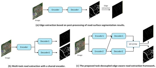
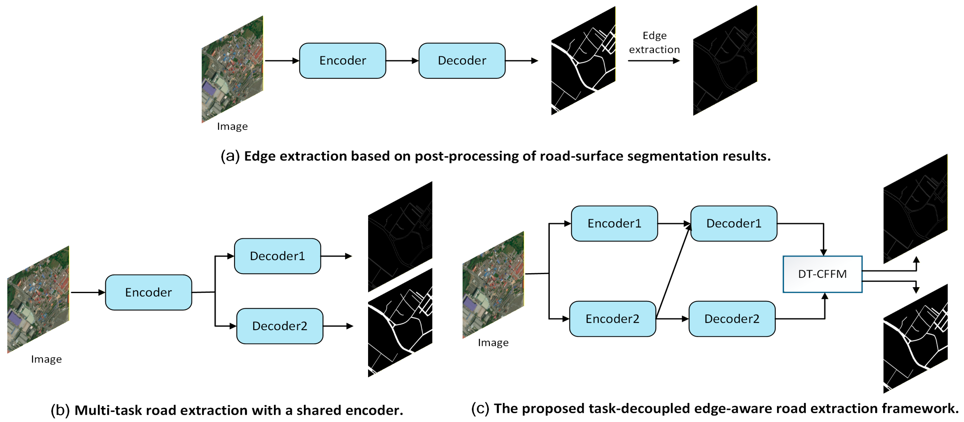
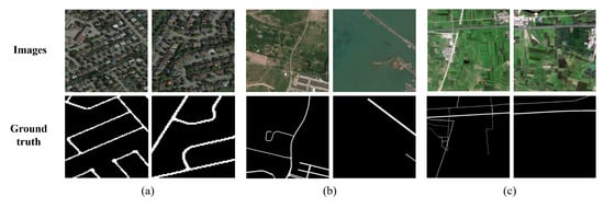
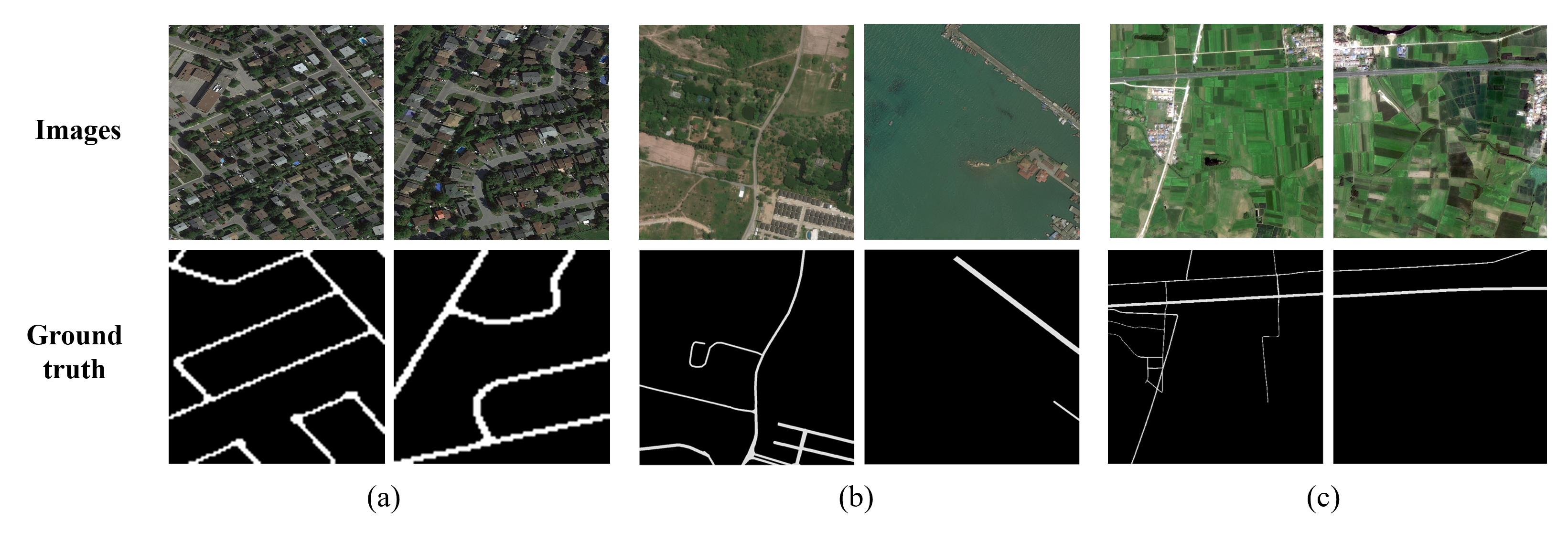
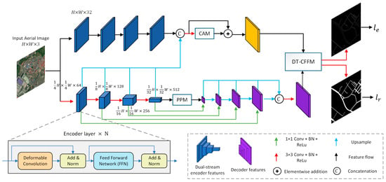
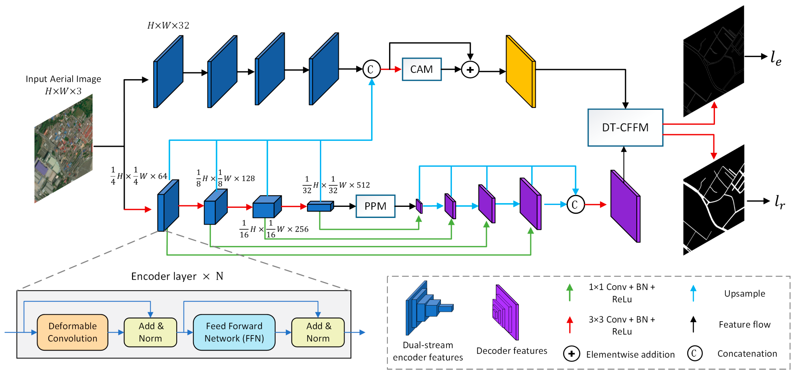
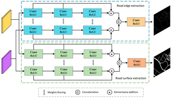
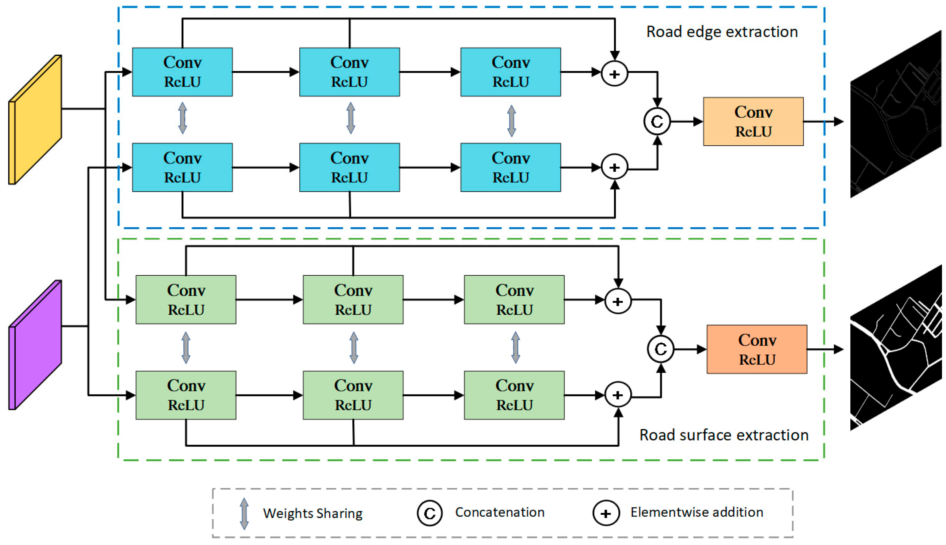
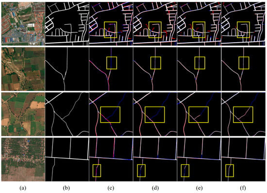
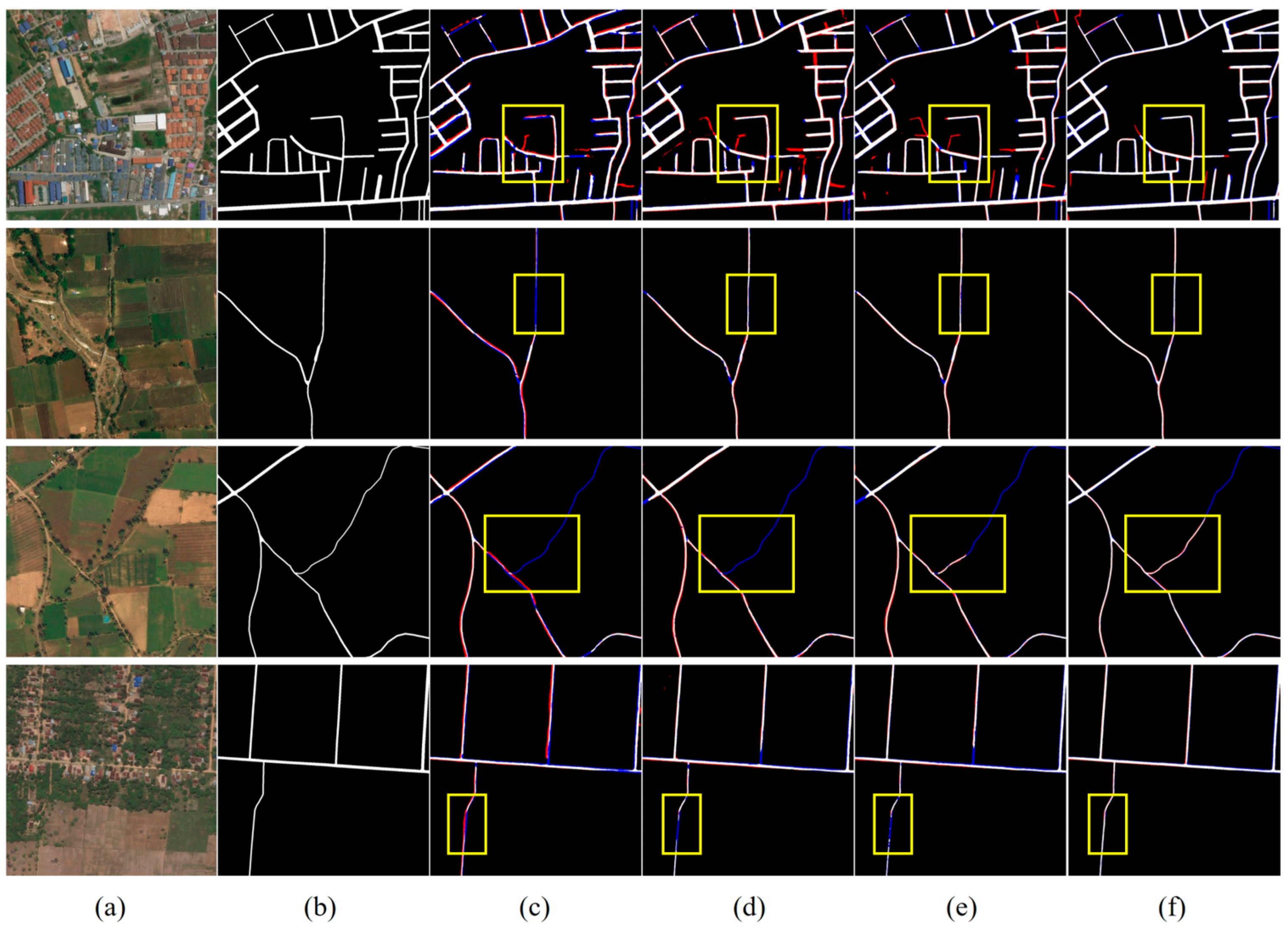
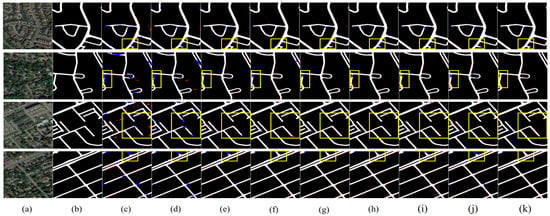
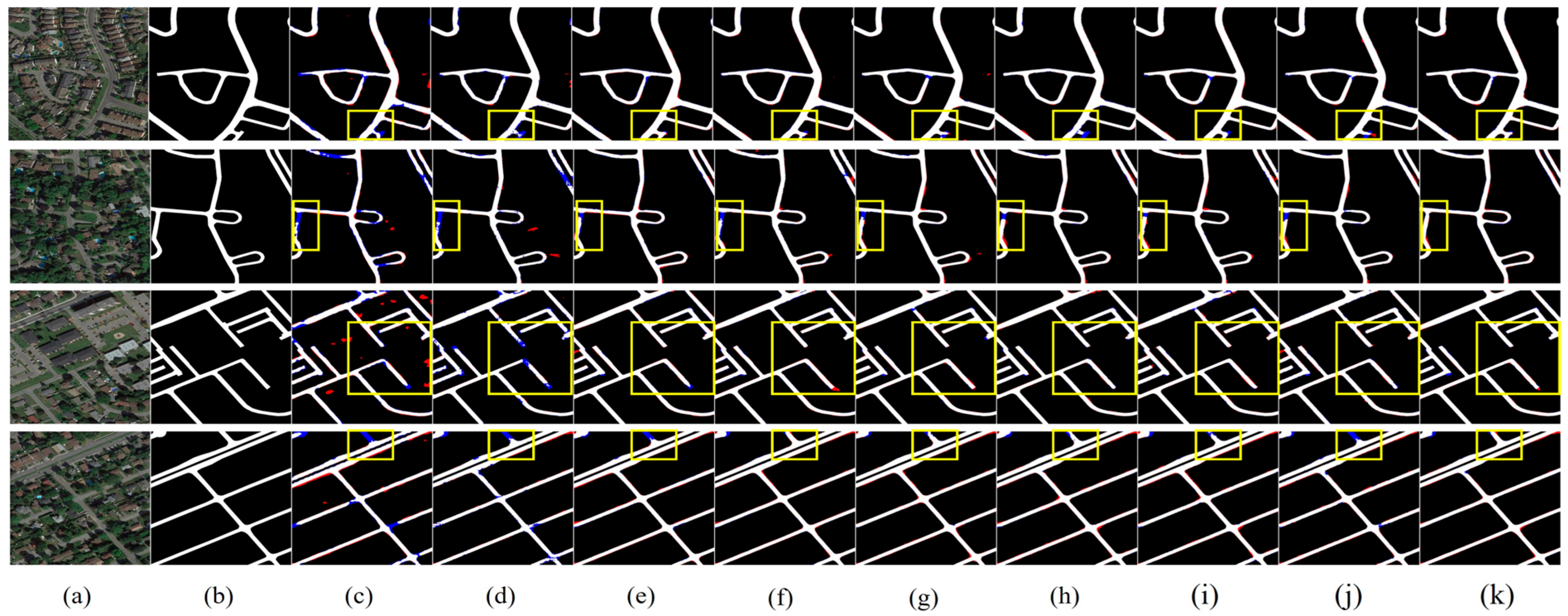
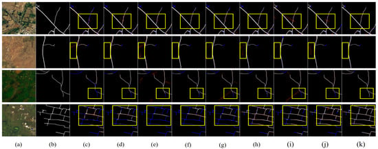
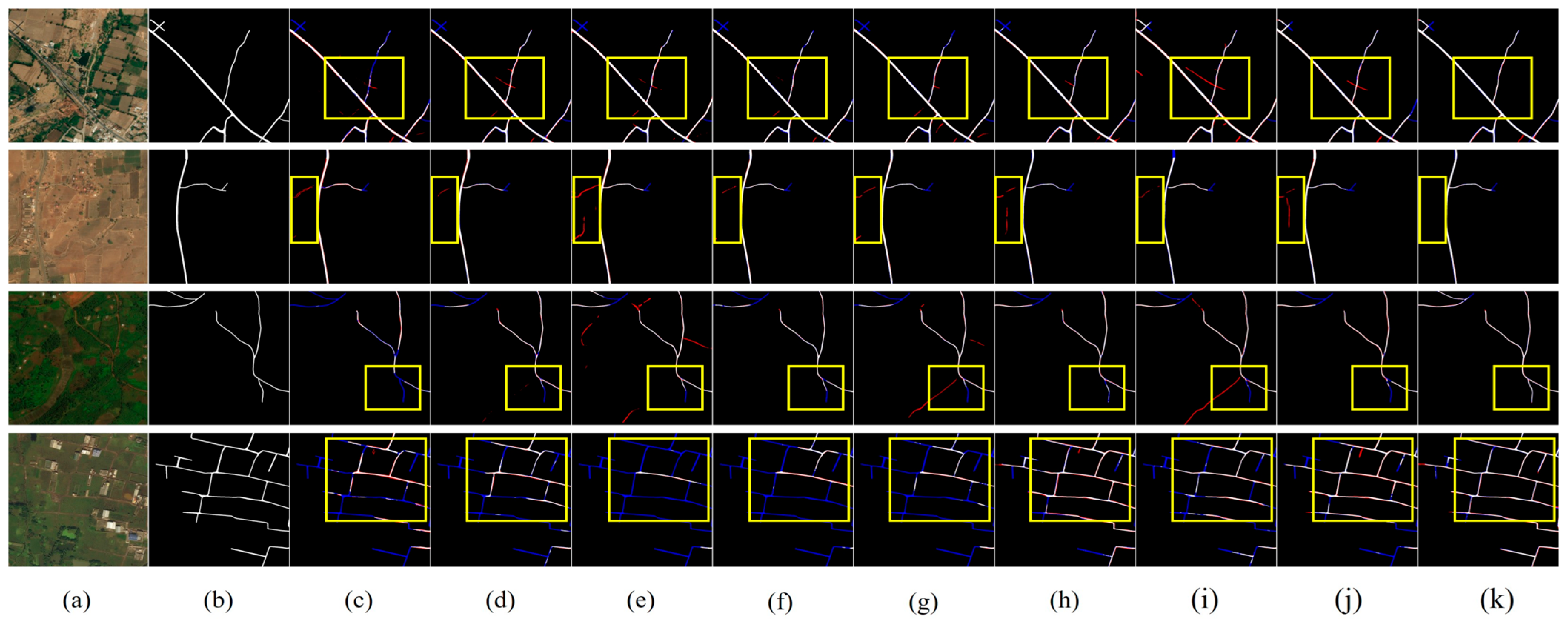
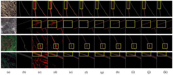
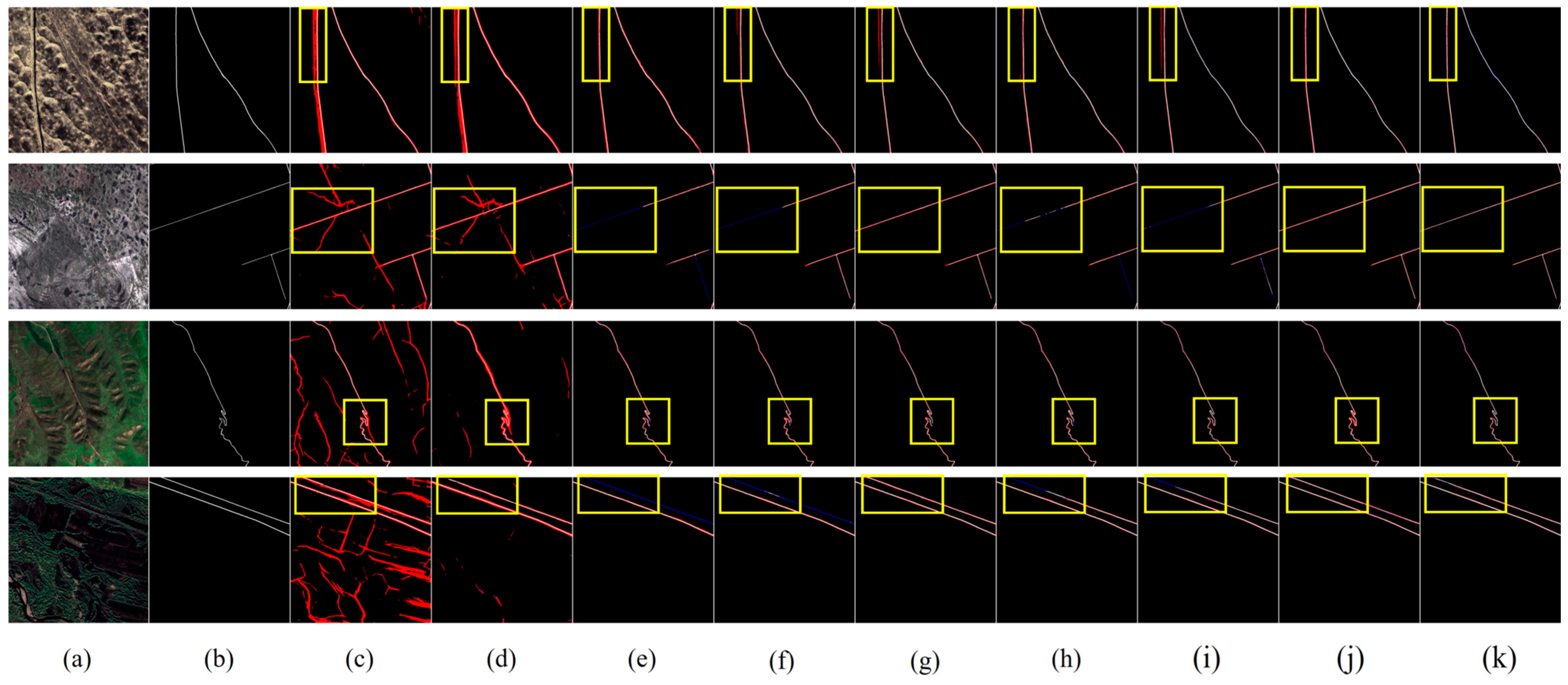
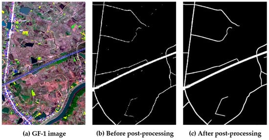
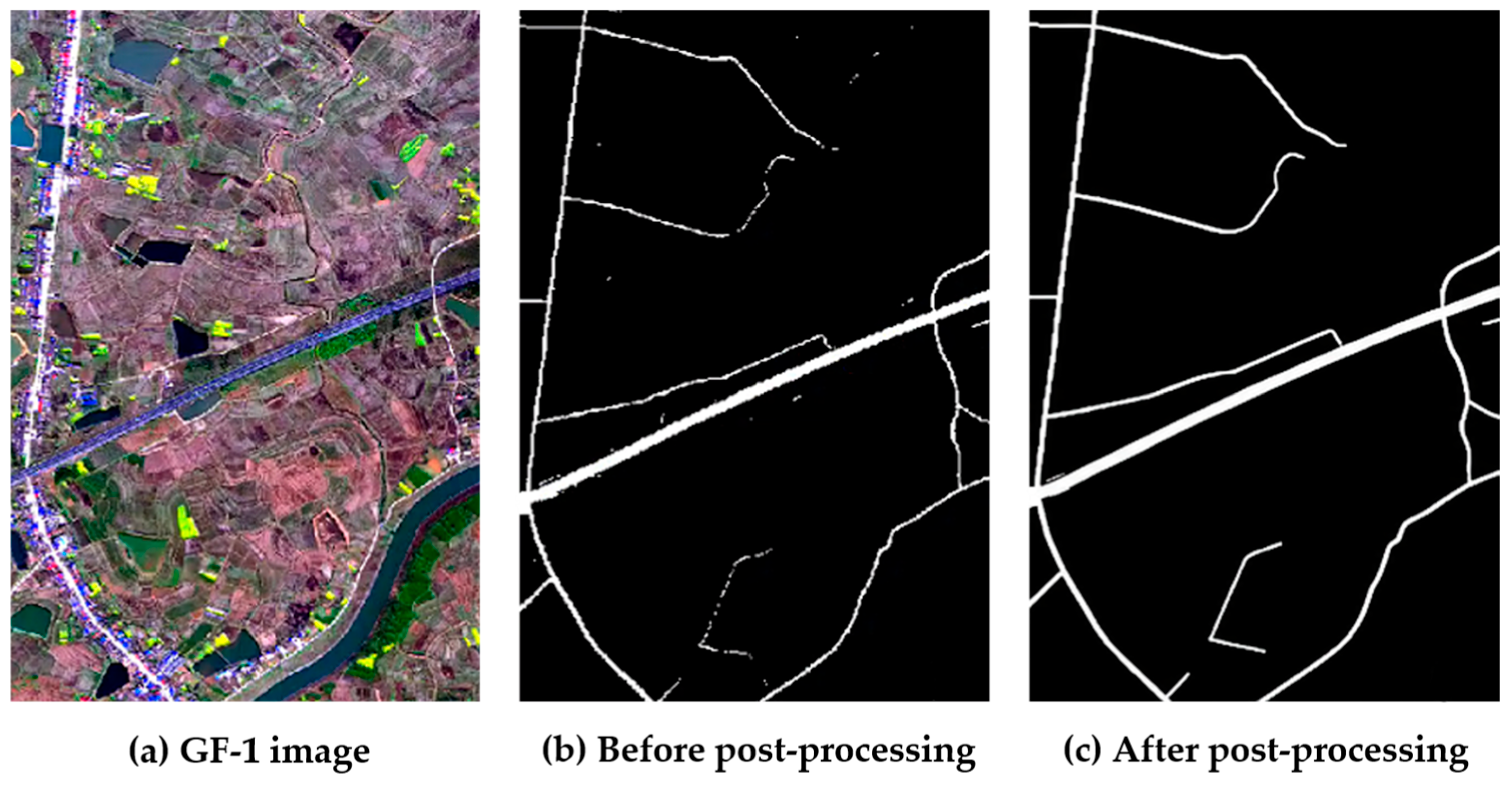
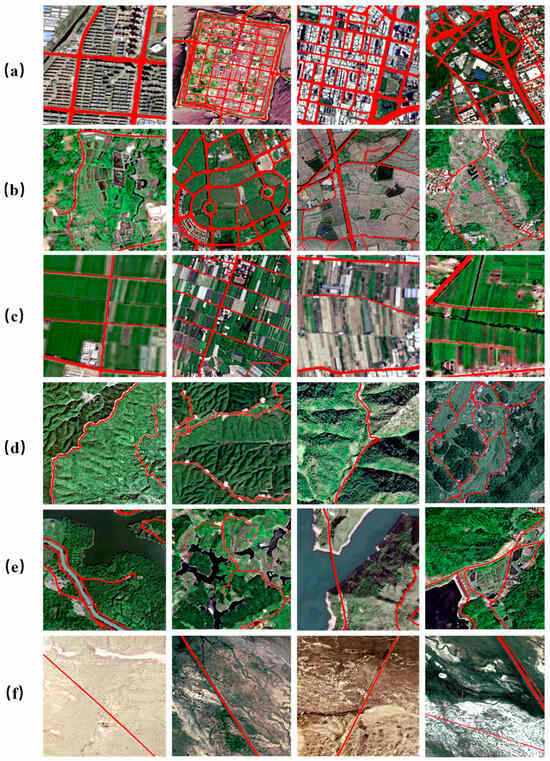
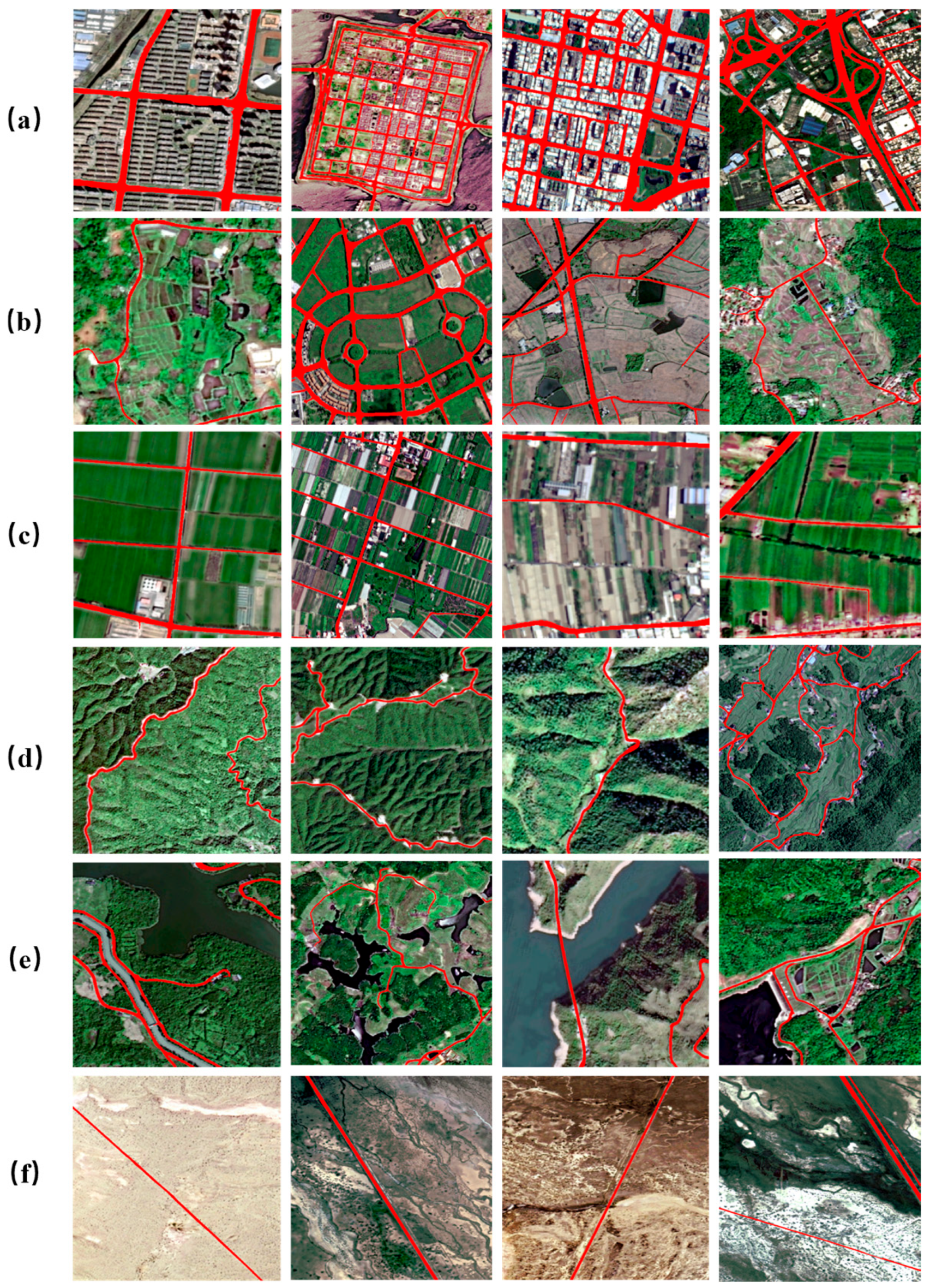
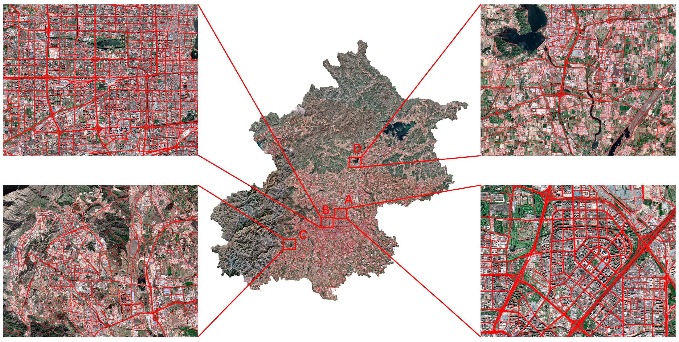
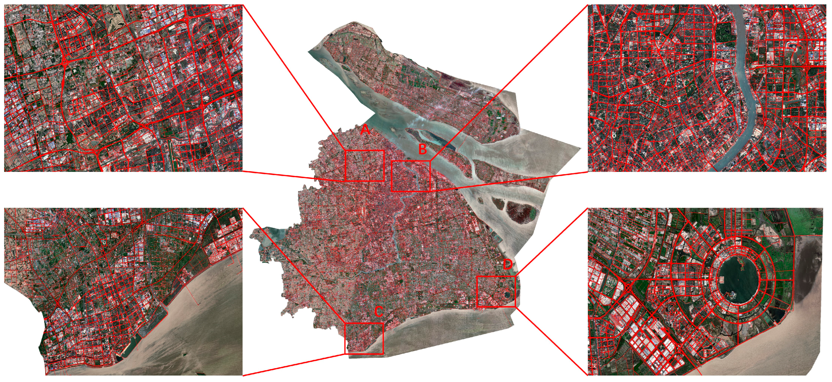
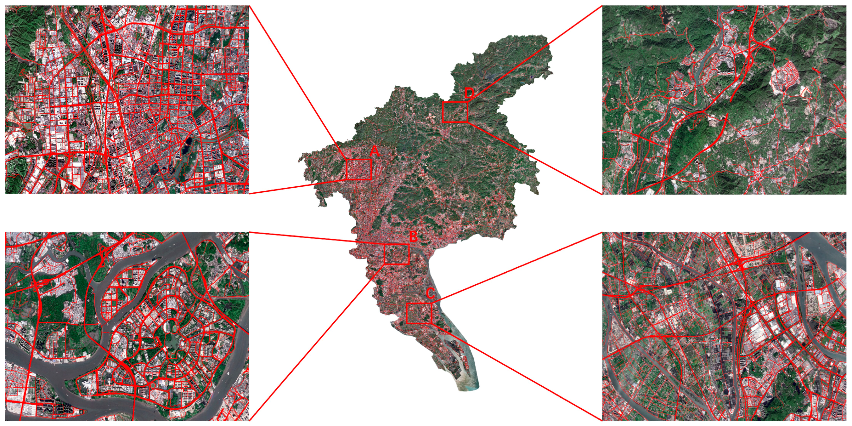
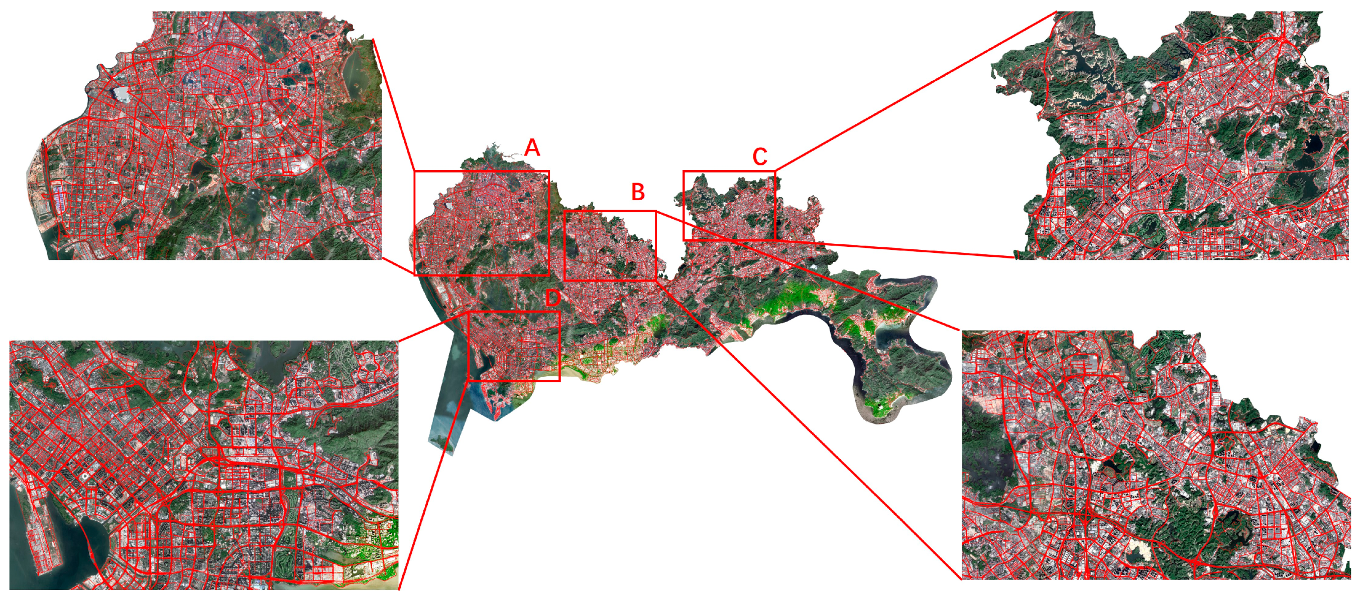

Disclaimer/Publisher’s Note: The statements, opinions and data contained in all publications are solely those of the individual author(s) and contributor(s) and not of MDPI and/or the editor(s). MDPI and/or the editor(s) disclaim responsibility for any injury to people or property resulting from any ideas, methods, instructions or products referred to in the content. |
© 2026 by the authors. Licensee MDPI, Basel, Switzerland. This article is an open access article distributed under the terms and conditions of the Creative Commons Attribution (CC BY) license.