


Highlights
What are the main findings?
- UAV multispectral and thermal surveys of four sites (15.4 ha; 1.87–4.61 cm resolution) detect archaeological features.
- Integrated datasets reconstruct Colchian hydro-settlement landscapes, including 9–10 m high mounds and 4265–6520 m2 ditches.
What are the implications of the main findings?
- UAV surveys reveal vegetation, moisture, and thermal anomalies enhancing archaeological visibility in wetlands.
- Non-invasive approach supports prospection, heritage monitoring, and provides reference data for future predictive modelling.
Abstract
This study investigates the potential of integrated multispectral and thermal UAV remote sensing for detecting and mapping hidden archaeological structures of Proto-Colchian and Colchian settlement systems of the 3rd–1st millennium BCE, within the Rioni River basin in western Georgia. Characteristic settlement mounds (Dikhagudzuba), moats/ditches, and possible paleochannel networks represent a unique example of large-scale adaptation to waterlogged environments, and limited archaeological excavations have significantly hindered the identification and interpretation of these buried landscape features. Pilot UAV surveys were conducted at four archaeological sites differing in location, geomorphological setting, land use, and degree of preservation using DJI Mavic 3M multispectral and DJI Matrice 4T thermal UAV platforms. Multispectral imagery enabled the detection of vegetation and soil-moisture anomalies associated with buried ditches, embankments, canals, and settlement structures, while thermal data revealed differences in thermal inertia related to subsurface archaeological remains and palaeohydrological features. The study covered approximately 15.4 ha and produced 5836 RGB, 2219 multispectral, and 3617 thermal images with spatial resolutions ranging from 1.87 to 4.61 cm. The integration of high-resolution elevation models, RGB imagery, vegetation indices (ExG and normalized EVI2), and thermal data enabled the identification and characterization of microtopographic, vegetation, moisture, and thermal anomalies associated with archaeological and palaeohydrological features. The investigated mounds cover 2754–4685 m2, reach approximately 9–10 m in height, and are surrounded by moats/ditches covering 4265–6520 m2 and ramparts reaching approximately 2–3.5 m in height. The results demonstrate that combined UAV-based multispectral and thermal remote sensing provides a highly effective non-invasive tool for archaeological prospection in dynamic wetland landscapes. The proposed approach significantly improves the detection of buried archaeological features and paleochannels, while also supporting landscape-scale analyses, monitoring of archaeological heritage, and the development of predictive archaeological models for western Georgia.
1. Introduction
The Colchian Plain, a marshy region in western Georgia, is characterized by an unusually dense and rich network of Bronze and Iron Age settlements. The characteristic structural elements of this flat, alluvial landscape are anthropogenic settlement mounds that rise above the marshy plains, locally known as Dikhagudzuba, which in the Megrelian language means ‘convex/elevated land’ [1,2]. According to current archaeological findings, the first mounds of this type were constructed in Colchis in the mid-third millennium BCE, following the formation of the alluvial plain by the Rioni River and its tributaries. These structures were created by communities of the Proto-Colchian culture and, later, the Colchian culture [3,4,5,6].
The settlement system of the Colchian Plain landforms is an organized network adapted to the humid environment. Three main types of Colchian settlements can be distinguished. The dominant Type A comprises settlements located on artificial mounds rising above the flat, open valley floor. They are typically surrounded by moats/ditches (their function has not yet been clearly defined, which is why this form is used throughout the paper) and earthen ramparts [2,7]. Type B refers to settlements established on natural elevations and plateaus [6,8,9,10]. Type C includes open settlements and workshops located on sand dunes along riverbanks and the Black Sea coast [11,12,13,14].
This article focuses on the poorly studied Type A settlement mounds, which are intentionally designed anthropogenic structures consisting mainly of semi-conical (dome-shaped) formations, with a circular or oval plan, formed as a result of earthworks and the movement of soil and surface sediments, while also containing strata formed through human activity.
Research on artificial settlement mounds has so far been focused primarily on two main areas: the Black Sea Littoral Zone (hereinafter: BSLZ), located along the Black Sea coast, and the Enguri–Ghubitskhali Zone (hereinafter: E-GZ), situated on the vast, flat plains deep within the Colchian Plain, between the two rivers from which the area derives its name [5,7,11,12,15,16,17,18,19,20,21,22,23,24,25,26,27,28,29,30,31,32]. Although the literature has also sporadically mentioned individual mounds located in the immediate vicinity of the city of Kutaisi [14,33], they were not grouped into a larger regional cluster, and no surveys were conducted there as part of archaeological excavation campaigns. This has resulted in a research gap regarding settlement patterns in Colchis during the Bronze and Iron Ages.
To address this gap as part of the Kutaisi Archaeological Landscape Project (KALP), an archaeological survey was conducted in the vicinity of the city of Kutaisi from 2019 to 2024, leading to the discovery of six new Bronze and Iron Age mounds, as well as structures, pottery, and artifacts from Late Antiquity and the Middle Ages. Based on surface surveys and geoarchaeological drillings, a preliminary assessment of the archaeological material was conducted, and a preliminary chronological framework was established for selected mounds. This provided the basis for identifying a new, third group of settlements: the Kutaisi Landscape Zone (hereinafter: KLZ) [6].
In the course of the work, it became apparent that traditional non-invasive archaeological methods are insufficient for a comprehensive understanding of these complex settlement systems. Environmental constraints pose a significant obstacle, as the area remains largely inaccessible, forested, muddy, and waterlogged for much of the year, making conventional surface surveys difficult. To gain deeper insight into the sites within the KLZ area, it became necessary to adopt a multidisciplinary approach, utilizing the latest technological advances in remote sensing alongside conventional geoarchaeological methods.
To better understand the nature of archaeological sites and to identify, document, and monitor them without the need for invasive excavations, non-invasive remote sensing methods are increasingly being used [34,35,36]. Their importance has grown significantly with the development of high-resolution satellite imagery, aerial LiDAR scanning, UAV photogrammetry, multispectral and thermal imaging, and geophysical methods integrated with spatial data [35,36,37].
One of the primary applications of remote sensing in archaeology is the identification of objects hidden beneath vegetation cover and below the ground surface based on so-called archaeological features [34,36]. These features include crop marks, soil marks, moisture marks, snow marks, and shadow marks [38]. The presence of ancient walls, foundations, and moats/ditches affects soil properties, moisture retention, and plant growth, leading to the formation of anomalies that can be observed in aerial photographs, satellite imagery, and multispectral data [39,40]. For several decades, the interpretation of such features has been one of the fundamental and still most important methods of non-invasive archaeological prospecting [36,37,40].
Aerial Light Detection and Ranging (aerial LiDAR or Airborne Laser Scanning—ALS) is of particular importance in non-invasive research. LiDAR data allow for the creation of digital terrain models (DTMs), even in forested areas where traditional aerial photography is limited by vegetation cover. By filtering the point cloud, it is possible to reveal microforms of the terrain, such as burial mounds, fortified settlements, ramparts, ancient roads, agricultural terraces, and the remains of defensive systems. In the literature, LiDAR is recognized as one of the most important technologies in landscape archaeology, particularly in the study of forested and hard-to-reach areas [41,42,43,44,45].
In recent years, the use of Unmanned Aerial Vehicles (UAVs) in archaeological research has been growing rapidly. Advances in sensor miniaturization, increased availability of UAV platforms (commonly known as drones), and progress in photogrammetric methods such as Structure-from-Motion (SfM) have made drones one of the fundamental tools for non-invasive archaeological surveying [35,36,46].
UAVs enabled the acquisition of imagery with very high spatial resolution (even sub-centimeter), at relatively low operating costs and with great flexibility in flight planning, which constitutes a significant advantage over traditional aerial photography and satellite imagery [47]. In archaeology, unmanned aerial vehicles are primarily used for documenting sites, creating orthophoto maps, three-dimensional (3D) models, digital terrain models (DTMs), digital surface models (DSMs), analyzing microtopography, and monitoring changes at archaeological sites [48,49].
Multispectral, hyperspectral, and thermal cameras mounted on UAV platforms are also being used with increasing frequency, enabling the detection of vegetation, soil, and thermal anomalies associated with the presence of hidden archaeological structures [35,50]. By incorporating these multidisciplinary tools into the initial reconnaissance phase, researchers can overcome limitations, ensure a strategic and precise selection of excavation sites, and simultaneously collect the data necessary for a preliminary interpretation of the sites and their surroundings.
Although the use of UAVs, specialized cameras, and advanced sensors is becoming increasingly common, and standard aerial photography and photogrammetry now form the basis of modern archaeological documentation, such remote sensing and digital recording techniques have never been used to survey the mounds and detect hidden archaeological structures in the KLZ.
To address this research gap, this study aims to verify the effectiveness of selected remote sensing methods in identifying archaeological sites. To achieve this objective, the following research questions were formulated:
- (1)
- Can remote sensing methods be used to determine the functions of mounds and changes in their use over time?
- (2)
- Can the use of remote sensing methods effectively identify anomalies associated with surface and subsurface archaeological features?
- (3)
- Is it possible to use remote sensing methods to reconstruct elements of the hydrographic network (e.g., ditches and canals) and their connections to river systems?
Based on the above questions, multidisciplinary research was conducted in which remote sensing methods supported non-invasive archaeology by revealing the nature, morphology, and spatial context of the mounds, the landscape in which they are located, and revealing elements of the hydrographic network that constitutes an integral part of Type A Colchian settlements in the eastern part of the Colchian Plain, an area that has been almost completely overlooked until now.
The characterization of these sites using remote sensing indicators, combined with geoarchaeological findings, provides an important basis for redefining the scale of the architectural and spatial complexity of the local settlement structures. This allows for a deeper understanding of the relationship between humans and the marshland and aquatic environments in ancient Colchis. On the other hand, it provides clear guidance regarding the limitations and directions of future non-invasive research supporting archaeological work in areas with challenging environmental conditions.
2. Materials and Methods
Research Program
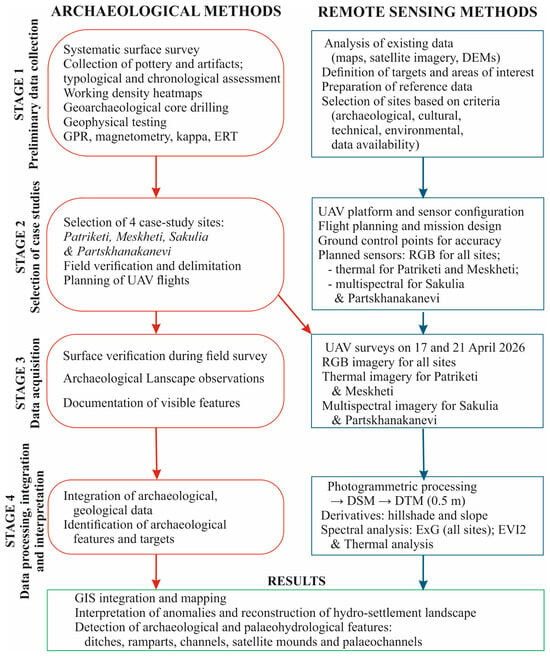
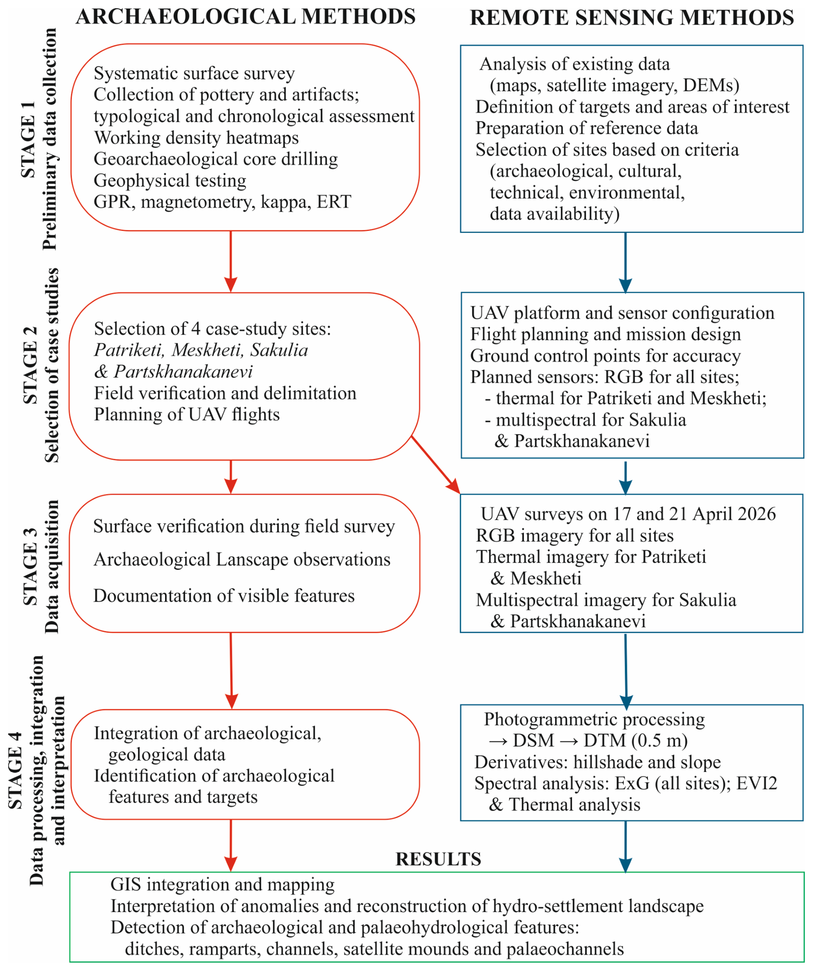
To carry out the research program, the work was divided into four phases (Figure 1). In the first phase, preliminary analyses were conducted based on data obtained from surface and geoarchaeological surveys carried out as part of the KALP initiative between 2019 and 2024 on six Colchian mounds (Patriketi, Meskheti, Sakulia, Partskhanakanevi, Didi Jikhaishi and Bashi) and their immediate surroundings outside the moat/ditch line. A systematic survey of the designated sites was conducted, involving the identification, mapping, and collection of pottery and artifacts found on the ground surface. For the comparative analyses conducted as part of this phase of the work, preliminary results of the analysis of the collected materials were used to establish a chronological framework.
Figure 1.
A flowchart illustrates the four main stages of the study, including, among others, the collection and processing of archaeological and remote sensing data.
So-called ‘working density heatmaps’ were developed for the surveyed mounds, showing clusters of specific archaeological material classified by type and chronology, as well as indicating areas with varying densities of archaeological remains. The work carried out made it possible to identify the most promising locations for excavations. However, due to environmental constraints—in particular, the exceptionally dense vegetation cover present year-round in the form of dense thickets and trees—it was impossible to fully complete the heatmaps. Geoarchaeological core drilling was conducted at the Patriketi, Meskheti, and Sakulia sites, where core samples were also collected from the waterlogged soil of the surrounding moat/ditch, which remains waterlogged and fully submerged year-round. All boreholes were documented using geological maps with stratigraphic and lithological profiles plotted on them, which were used for comparative analysis (Figure 1).
As part of the multidisciplinary analysis of the study sites, the results of geophysical surveys conducted at the Sakulia and Meskheti sites using various methods and measuring devices (GPR, magnetometer, kappameter, ERT) were also utilized to assess their effectiveness. These studies showed that soil conditions precluded the effective use of GPR (signal loss occurred at depths as shallow as 30–80 cm). This method also proved ineffective due to environmental factors (dense underbrush and forested areas within the study area) and the hilly nature of the terrain. Both the kappameter and the magnetometer provided ambiguous data, which was often affected by measurement errors. These two devices are also characterized by limited penetration depth and poor performance in hilly terrain. In contrast, ERT using a dipole–dipole array proved highly effective. It enabled the acquisition of clear subsurface profiles reaching depths of 4.5–7.5 m and allowed for the identification of geophysical anomalies. The results obtained served as the basis for identifying and locating subsurface anomalies and for a preliminary assessment of the depth of the moats/ditches and canals surrounding the mounds.
In the second stage, case studies were selected (Figure 1). The criteria for selecting the mounds that were included in the detailed investigations were: (1) preliminary archaeological surveys; (2) the presence of artifacts associated with the Colchian culture; (3) the absence of previous remote-sensing surveys; (4) varied land cover, particularly tall trees and canals, which posed significant obstacles to conducting traditional non-invasive archaeological surveys. An additional criterion was the availability of data.
In the third phase (Figure 1), in April 2026, remote sensing data were acquired for four selected sites (Patriketi, Meskheti, Sakulia, and Partskhanakanevi) as part of the Archaeological Reconnaissance and Geomorphological Overview of the Colchian Settlement System (ARGOS) initiative, carried out in the frame of KALP (Figure 1, Table 1). UAV flights were conducted over areas larger than those identified during archaeological surveys (the hill and the moat/ditch) in order to detect previously unidentified surface and subsurface features associated with the archaeological site in question and to verify features already known from earlier non-invasive archaeological surveys.
Table 1.
Basic parameters of the UAVs, the sensors used, and the images obtained.
The study utilized DJI drones—the Mavic 3M (© DJI, Shenzhen, China), equipped with an RGB camera and a multispectral camera (G, R, RE, NIR), and the Matrice 4T (© DJI, Shenzhen, China) (Table 1), equipped with an RGB camera and a thermal camera (measuring in the 8–14-micrometer range). The data were acquired with surveying-grade accuracy. Flight passes were conducted with 70% longitudinal overlap and 80% lateral overlap to ensure photogrammetric processing was possible (Table 1). A detailed digital elevation model (DEM) was developed for each site.
A thermal sensor was used for two of the four study sites (Patriketi and Meskheti), while a multispectral sensor was used for the other two (Sakulia and Partskhanakanevi); this was dictated by the desire to account for various aspects of the spectral response within the studied areas. This approach made it possible to verify whether the differing characteristics of the acquired data affect the ability to identify analogous patterns and processes across all study sites. At the same time, the Excess Green (ExG) index [51] was calculated for all four sites, which established a common reference framework and enabled a direct, objective comparison of vegetation cover and condition across all analyzed areas (Figure 1).
Due to significant discrepancies in the absolute values of the EVI2 (Enhanced Vegetation Index) [52] between the analyzed areas, it was necessary to perform a data standardization procedure [53]. The analyzed areas were characterized by different specific features and environmental backgrounds, which resulted in varying dynamics and ranges of the vegetation index. The use of standardization (z-score) made it possible to eliminate the influence of extreme differences in absolute EVI2 levels, bringing the data into a common range with a mean of zero and a standard deviation of one. Thanks to this approach, it became possible to objectively assess and directly compare relative changes and variations in vegetation conditions across the studied areas, regardless of their baseline levels of biological productivity.
The physical parameters of the studied objects were estimated using digital elevation models (DEMs). These were generated from RGB imagery using Agisoft software 2.3.2 (© Agisoft LLC). The resulting point clouds were then processed into four digital terrain models (DTMs) using Cyclone 3DR software 2026.1.3 (© Hexagon/Leica Geosystems). Ground surfaces were obtained through a classification process using the ‘clean/split ground points’ and ‘clean/automatic/classification/heavy/construction/UAV 2.0’ tools. The resulting ground point clouds were exported in *.las format and processed into raster DTMs with a spatial resolution of 0.5 × 0.5 m using ArcMap 10.8 software (© ESRI). To ensure the accuracy of the DTM, the ‘Create LAS Dataset’ and ‘LAS Dataset to Raster tools’ were used. Basic measurements of the physical characteristics of the studied objects were performed on the resulting model using the ‘Measure’ tool. For better visualization, based on the results of the tests conducted, a DEM derivative in the form of shading was applied. This approach made it possible to highlight objects with various geometries that were previously difficult to recognize.
3. Study Area
3.1. Geographical Characteristics
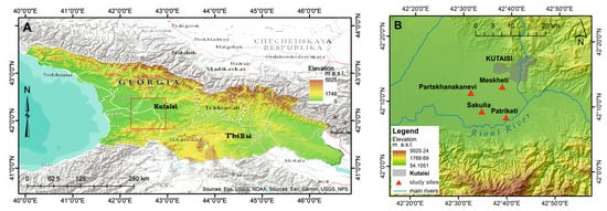
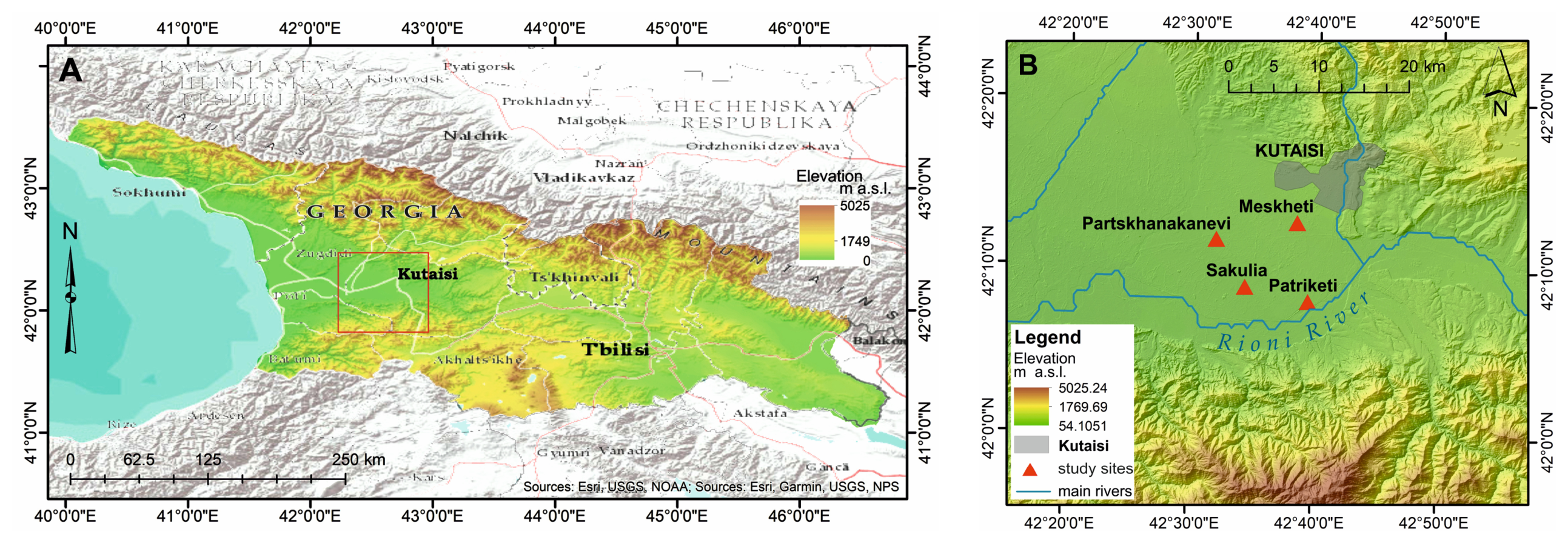
All four study sites are located in the so-called Kutaisi Landscape Zone (KLZ), one of the three main clusters of Colchian settlements in western Georgia (Figure 2A). The area covers a significant portion of the Imereti region. It stretches from the Ghubitskhali River in the west and northwest to the foothills of the Racha Range—a mountain range belonging to the Greater Caucasus—in the north and northeast, and to the foothills of the Likhi Range—between the towns of Zestaponi and Shorapani—in the east. The southern border is formed by the foothills of the Lesser Caucasus (Meskheti Range) along a line (from east to west) connecting the towns of Kldeeti, Baghdati, Vani and Sajavakho.
Figure 2.
(A) Location of the study area shown on a hypsometric map of Georgia. The red rectangle delineates the study area. (B) Location of the study area and archaeological sites in the KLZ.
The main city of the study area and the administrative capital of the Imereti region is Kutaisi, which is located on the border between the end of the upper course and the beginning of the middle course of the Rioni River (Figure 2B). This river crosses the entire study area from west to east, continuing toward the Black Sea as it meanders through the Colchian Plain. The Ghubitskhali River is the largest right tributary of the Rioni River. The total area of the Kutaisi Landscape Zone is approximately 2100 km2.
All of the studied sites are located within the marshy Colchian Plain, which is part of the Georgian tectonic intermontane plain that took on its final form during the late Tertiary (Pliocene) and Quaternary periods. As a result of intense subsidence during the Pliocene, thick layers of marine sediments accumulated here. After the marine transgression receded during the Quaternary, the area continued to subside, and the landform was shaped by processes of erosion and denudation. By the end of the Pleistocene, the landscape had taken on its present-day appearance. Due to its geological setting, hydromorphic soils are common in the Colchian Plain, including marsh soils, fluvial and alluvial soils, and subtropical podzolic soils. The marsh sediments found here, dating back approximately 6000 years (composed of peat and sapropel), are associated with the ‘New Black Sea transgression phase’. The maximum thickness of these sediments is approximately 9 m [54].
3.2. Study Site Description
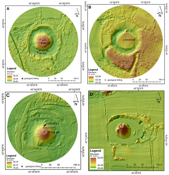
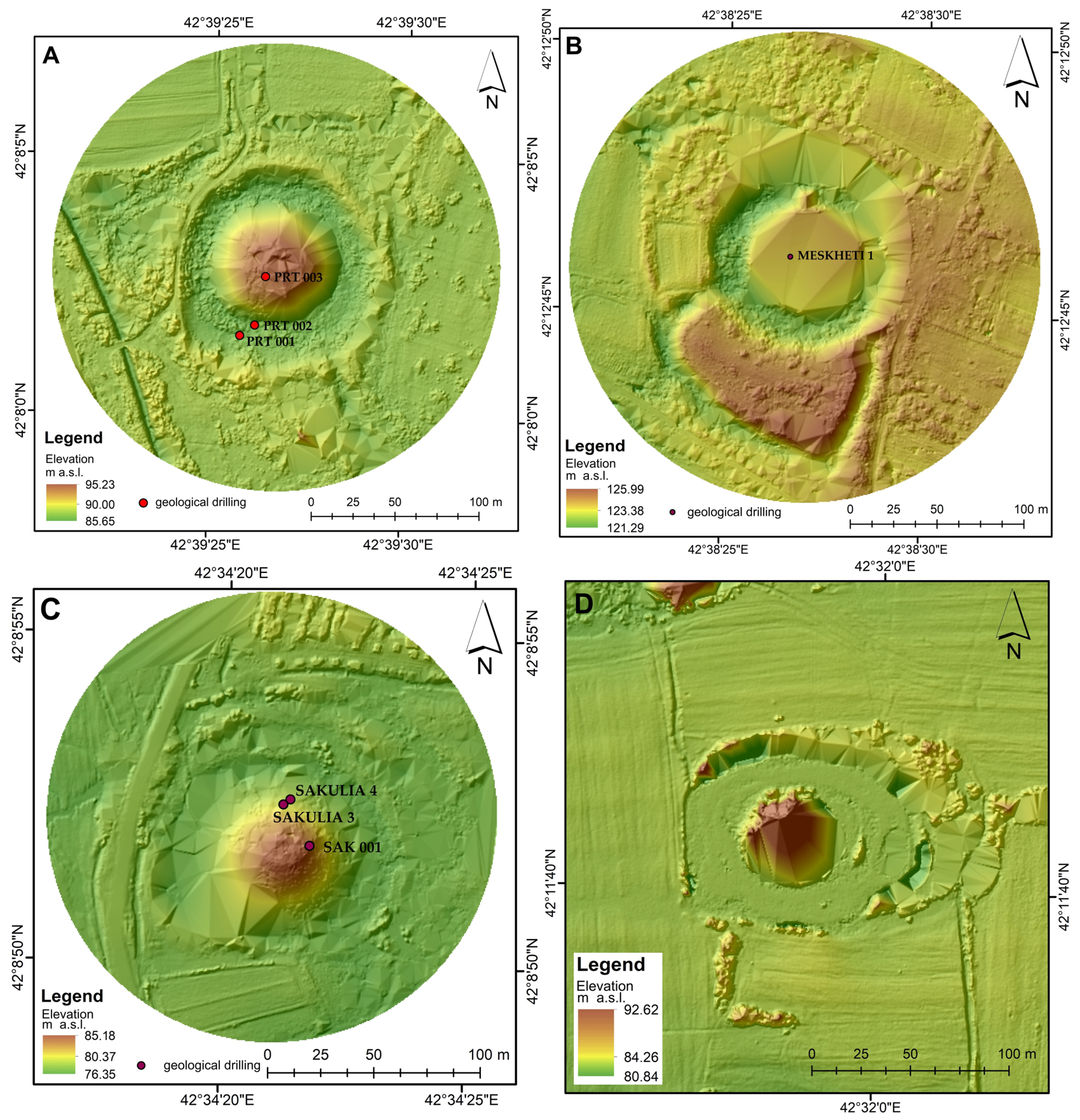
The studied archaeological sites—Patriketi, Meskheti, Sakulia, and Partskhanakanevi—are located in the KLZ near the city of Kutaisi (Figure 3A–D).
Figure 3.
DTMs of the studied archaeological sites: Patriketi (A), Meskheti (B), Sakulia (C), and Partskhanakanevi (D); the sketches show the locations of the geoarchaeological boreholes.
The Patriketi site (Figure 3A) is located about 15 km south of Kutaisi and consists of a mound surrounded by a wide moat/ditch and a rampart. The mound currently serves no economic purpose, and a former elevation benchmark has been preserved at its summit. The area surrounding the site, however, features a variety of infrastructure. About 150 m to the west are the ruins of a former water treatment plant, and less than 300 m to the south runs an artificial canal diverting water from the Rioni River, alongside which a dam and the buildings of the Vartsikhe 2 Hydroelectric Power Plant are located. The area between the mound and the channel consists of wasteland and abandoned residential buildings, with farmland stretching beyond. A field road runs along the crest of the embankment surrounding the site on the western and northwestern sides. During restoration work on the outskirts of the mound, fragments of unidentified wooden structures were found lying just below the surface [33,55].
The Meskheti site (Figure 3B), located about 8 km southwest of Kutaisi, takes the form of a mound surrounded by a moat/ditch and a rampart. On its southern side, it adjoins an additional area also enclosed by a rampart, which in the past was an integral part of the settlement. The mound remains unused, and its summit features only a former elevation benchmark. It is surrounded by farmland to the west and north, and by residential buildings to the east. The area enclosed by the southern rampart is also currently occupied by farmland. Two local dirt roads run through the immediate vicinity. The entire area surrounding the mound is also used today as pastureland.
The Sakulia site (Figure 3C), located about 18 km southwest of Kutaisi, is unique in that it is the only one situated directly within the boundaries of a compact settlement. The mound, surrounded by a moat/ditch, serves as a religious function for the local community; a small chapel has been erected at its summit. On the eastern and southern sides, the site is bordered by the town’s buildings, along with gardens and backyard plots, while to the north it is directly adjacent to an active cemetery. A concrete road runs right along the western edge of the site, beyond which, in the northwest, west, and southwest directions, extensive pastures stretch out. In the vicinity of the mound, there is also a small forest concealing the remains of a settlement from the Early Antiquity-Hellenistic period [56].
The Partskhanakanevi site (Figure 3D) is located about 16 km west of Kutaisi and takes the form of a mound surrounded by a very wide moat/ditch. It lies in open terrain crisscrossed by several poorly preserved dirt roads. The immediate surroundings of the site consist of wasteland and wetlands. The area is surrounded by extensive farmland and pastures. The mound itself is completely undeveloped. Access to it is extremely difficult due to the dense forest covering it and the moat/ditch, which is constantly filled with water.
4. Results
4.1. Archaeological and Geoarchaeological Context
Surface surveys conducted as part of the KALP at selected Type A settlements have yielded a substantial collection of archaeological material recovered from the surface dated to the Late Bronze-Early Iron Age, Early Antiquity (in Georgia corresponding to the Archaic and Classical periods in the Mediterranean) and Hellenistic period (1300–200/100 BCE). Although the vast majority of the collection consisted of ceramic fragments, individual diagnostic artifacts, such as spindle whorls and stone tools, were also found. Furthermore, numerous fragments of earthen building materials (EBMs) were discovered throughout the mound area. Many of these EBM fragments bear clearly visible organic imprints, primarily of wood and plant fibers. These impressions are of great significance for reconstructing the appearance of buildings and other structural elements within the settlements. The abundance of EBM was expected, given that wattle-and-daub structures were the dominant building style in Colchis throughout all protohistoric periods.
The archaeological work was supported by hand-drilled geological boreholes. These boreholes made it possible to determine the thickness of the layers likely to contain archaeological objects and the types of sediments, and to interpret the environment in which they were deposited. This survey was conducted on the mounds and at their bases in Patriketi, Meskheti, and Sakulia (Table 2).
Table 2.
Location and findings of geological surveys.
4.2. Results of Remote Sensing Studies
Remote sensing surveys were conducted at four archaeological sites—Patriketi, Meskheti, Sakulia, and Partskhanakanevi—on 17 and 21 April 2026 (Table 1). In total, the aerial surveys covered an area of approximately 154,000 m2 (15.4 ha), ranging from 30,000 m2 (Patriketi) to 50,000 m2 (Partskhanakanevi). The surveyed sites are characterized by low absolute elevations: from 86 m a.s.l. (Partskhanakanevi) to 125 m a.s.l. (Meskheti). The flight altitudes above ground level (AGL) varied from 40 m AGL (Sakulia) to 100 m AGL (Partskhanakanevi) and were adjusted to suit environmental conditions. Consequently, the images yielded different pixel sizes: from 1.87 cm (Sakulia) to 4.61 cm (Partskhanakanevi). The largest set of images was obtained for Partskhanakanevi (2288 images), while the smallest was for Sakulia (1024 images). Vegetation cover and land use varied across the individual sites. Meteorological conditions during the measurements were generally favorable. Clear skies prevailed, and the air temperature ranged from 20 °C to 25 °C. The best wind conditions (calm) occurred in Sakulia; in Patriketi and Meskheti, the wind was moderate, while in Partskhanakanevi, it was strong (Table 3).
Table 3.
Basic parameters of carried out air missions.
As a result, a complementary set of remote-sensing data was obtained, comprising 5836 high-resolution RGB images, 2219 multispectral images and 3617 thermal images, with a spatial resolution of 1.87–4.61 cm (Table 1). The acquired dataset formed the basis for the production of orthophoto maps, DSM and DTMs, as well as spectral and thermal analyses used to identify and characterize archaeological sites.
4.3. Characteristics of the Studied Sites in the Context of the Data and Indicators Obtained
4.3.1. RGB Natural-Color Orthophotos
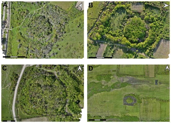
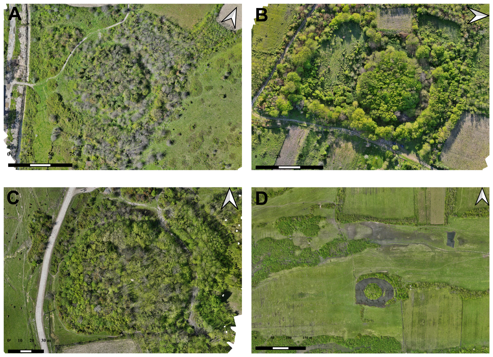
The generated RGB orthophoto maps show that all four sites have a distinct, concentric spatial layout, comprising a central mound and the surrounding remains of moats/ditches and embankments; however, the degree to which these features are visible, and the nature of the vegetation cover vary (Figure 4A–D).
Figure 4.
Orthophoto map of the archaeological sites in natural Red, Green, Blue (RGB) colors: (A) Patriketi, (B) Meskheti, (C) Sakulia, and (D) Partskhanakanevi.
At the Patriketi site, the central, oval-shaped mound is overgrown with scrub and trees, and its boundaries are marked by a ring-shaped layout corresponding to a moat/ditch and an outer rampart. The western part of the site is bounded by a modern drainage canal and a parallel dirt track (Figure 4A). In Meskheti, the central mound is heavily wooded and surrounded by a distinct depression interpreted as a moat or ditch, as well as an outer belt of vegetation. Its surroundings consist of a mosaic of arable fields, pastures, dirt tracks and clusters of trees and shrubs (Figure 4B). At the Sakulia site, the central mound is almost entirely covered by dense woody and shrubby vegetation, which limits direct observation of its morphology. Nevertheless, the ring-shaped boundary zone associated with the course of the moat/ditch and the rampart remains clearly visible (Figure 4C). Partskhanakanevi exhibits the most regular structure in the RGB imagery, where the central, circular ‘island’ is surrounded by a wide and distinctly contrasting ring of moat/ditch. The site is situated in an open landscape of meadows and pastures, with wetlands and water bodies to the north (Figure 4D). The RGB images therefore show varying degrees of clarity in the structures: from Sakulia, which is heavily obscured by tall vegetation, to the very regular and distinct ring-shaped layout of Partskhanakanevi.
4.3.2. Digital Surface Models (DSMs)
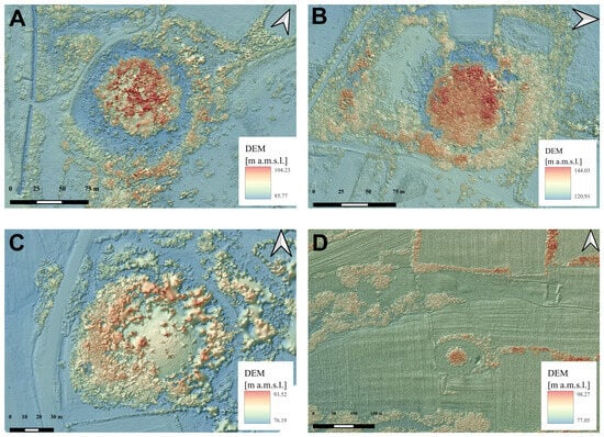
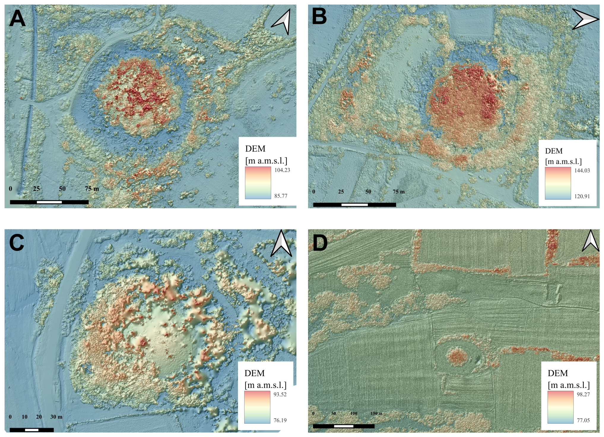
The DSMs confirm the presence of central elevations surrounded by depressions corresponding to fossae/troughs and, to varying degrees, external elevated features (Figure 5A–D). At the same time, they reveal significant differences in the total elevation difference in the analyzed areas. The smallest was recorded in Patriketi—approximately 10.1 m, whilst the largest was in Partskhanakanevi—approximately 23.4 m; a similar value, exceeding 23 m, was recorded in Meskheti. It is important to consider the impact of tall vegetation on DSM values, particularly within heavily wooded mounds.
Figure 5.
Digital Surface Models (DSMs) of the archaeological sites: (A) Patriketi, (B) Meskheti, (C) Sakulia, and (D) Partskhanakanevi.
At the Patriketi site, absolute elevations range from 83.70 to 93.80 m a.s.l., which corresponds to the smallest elevation difference among those analyzed, amounting to approximately 10.1 m. The lowest values occur in the western part of the area, along the drainage ditch, and within the moat/ditch surrounding the mound. The maximum elevations, exceeding 93 m above sea level, are concentrated in the central and north-central parts of the central mound. The model clearly illustrates the mound–moat/ditch–outer elevated zone configuration, as well as two linear anomalies in the north-eastern and south-eastern parts of the site, oriented towards the River Rioni (Figure 5A).
In Meskheti, elevation ranges from 120.9 to 144.0 m a.s.l., meaning the difference in height exceeds 23 m. The central mound forms the most prominent peak in the model, although the maximum values are also influenced by the dense canopy of tall trees. The lowest areas, at around 120.9–122.0 m a.s.l., are found within the moat/ditch and in the north-western part of the surrounding area. Outside the moat/ditch, a ring of elevated terrain is visible, whilst to the south of the main site, an additional, roughly rectangular feature stands out, surrounded by structures resembling a rampart and a moat/ditch (Figure 5B).
In Sakulia, elevation ranges from 76.4 to 91.9 m a.s.l., resulting in a vertical difference of approximately 15.5 m. The lowest values, around 76.4–78.0 m a.s.l., are found in open areas to the north-east and south. The maximum elevation of 91.9 m a.s.l., however, is not directly associated with the center of the mound, but with a ring of tall tree and shrub vegetation, particularly well-developed in the western and north-western parts. The model also reveals anomalies that may correspond to a channel connecting the moat/ditch to the river network, as well as the remains of external site structures (Figure 5C).
The greatest elevation range is found at Partskhanakanevi, where DSM values range from 74.8 to 98.2 m a.s.l., resulting in a vertical difference of approximately 23.4 m. However, most of the plain surrounding the site lies at an elevation of only around 75–77 m a.s.l., whilst values exceeding 98 m a.s.l. are associated with the central core and clusters of tall vegetation. The regular, circular arrangement of the central elevation and the surrounding depression is particularly clear. Beyond the site itself, there are also elongated landforms which may correspond to the remnants of a former hydrographic system (Figure 5D).
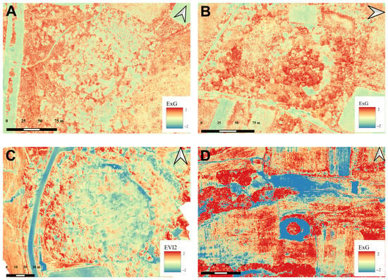
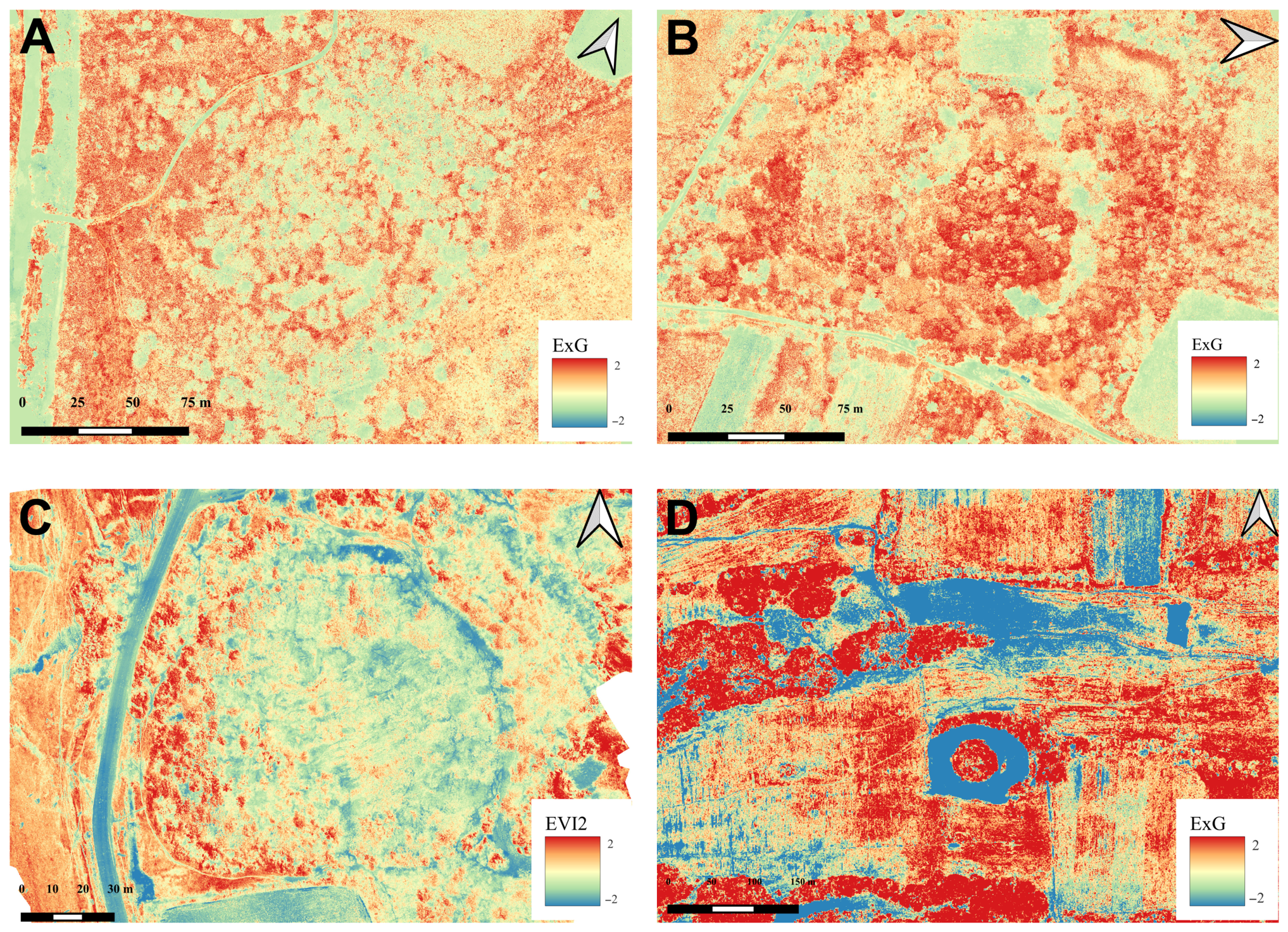
4.3.3. The Excess Green (ExG) Index
Analysis of the Excess Green (ExG) index reveals a spatial relationship between the condition of the vegetation cover and the micro-relief, as well as the course of ground features (Figure 6A–D). The most characteristic pattern is the occurrence of elevated ExG values on central ridges and sections of embankments, and reduced values within ditches and other depressions. However, the strength of this contrast varies between sites.
Figure 6.
Excess Green (ExG) index for the archaeological sites: (A) Patriketi, (B) Meskheti, (C) Sakulia, and (D) Partskhanakanevi.
At Patriketi, the central mound and the ring-shaped sections of the ramparts are characterized by elevated ExG values, whilst the course of the moat/ditch is marked by an arc-shaped zone of lower values. The picture is complemented by numerous point-like spectral anomalies, indicating local variations in soil conditions, micro-topography and vegetation composition (Figure 6A).
In Meskheti, the contrast between elevated and depressed features is particularly pronounced. The central mound and the summit sections of the ramparts show high ExG values, whilst the moat/ditch, canals and communication routes show lower values. A particularly marked decrease in ExG values is evident in the northern and north-eastern parts of the moat/ditch, which may be linked to higher soil moisture levels. The index also identifies modern roads and infrastructure elements very effectively (Figure 6B).
The image with the lowest contrast was obtained for Sakulia, where the central part of the site is characterized by relatively uniform ExG values. Locally, however, there are isolated anomalies with elevated values and arc-shaped zones of reduced values, which may correspond to levelled potholes/gullies or former watercourses. Particularly distinct is a band of low ExG values (<0) in the western part of the analysed area, interpreted as the trace of a river channel, canal or ditch (Figure 6C).
The highest recorded ExG contrast is found in Partskhanakanevi. The central mound reaches values of >0.6, indicating dense and well-developed vegetation cover, whilst the surrounding moat/ditch forms an almost continuous ring with values falling below −0.6. The difference between these extreme classes therefore exceeds 1.2 index units. Outside the moat/ditch, fragments of the rampart and irregular clusters of vegetation with heightened vegetative activity are visible, particularly in the western and north-western parts (Figure 6D).
4.3.4. Normalized EVI2 Index
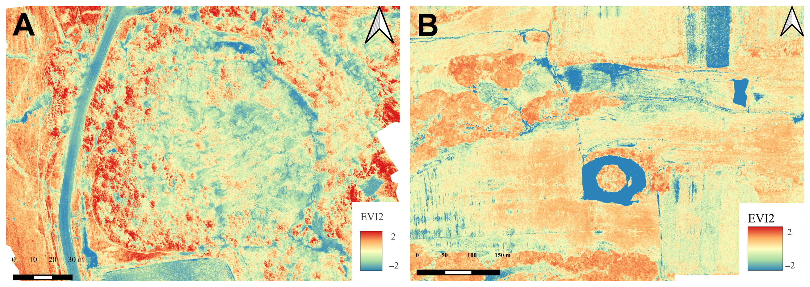
The normalised EVI2 index, calculated for the Sakulia and Partskhanakanevi sites, highlights the spatial variation in vegetation condition associated with the micro-topography and the layout of archaeological features, with the nature of the anomalies differing markedly between the two sites (Figure 7A,B).
Figure 7.
Normalized EVI2 index for the archaeological sites: (A) Sakulia and (B) Partskhanakanevi.
At Sakulia, most of the area shows values close to the mean, whilst significant deviations are concentrated primarily in the western part of the site and in several smaller zones within the settlement (Figure 7A). Some of these correspond to features identified on the elevation models, including linear depressions and ditches.
A particularly distinct negative anomaly in the south-western part may indicate a depression with increased moisture content or the remnant of a former ditch or canal; a smaller area of a similar nature is also present in the north.
At Partskhanakanevi, EVI2 reflects the regular geometry of the site much more clearly (Figure 7B). The dominant feature is a closed, circular negative anomaly corresponding to a moat or ditch surrounding the central mound, the values of which remain essentially similar to the background. In the northern and north-eastern parts of the image, there are also elongated negative anomalies associated with depressions in the terrain, former watercourses and modern transport routes. The normalized EVI2 therefore indicates a different nature of the signal at the two sites: at Sakulia, it reveals mainly local and discontinuous anomalies, whilst at Partskhanakanevi it clearly highlights the regular course of the moat/ditch, enhancing the clarity of the relationship between terrain structures and spatial variation in vegetation.
4.3.5. Thermal Imaging
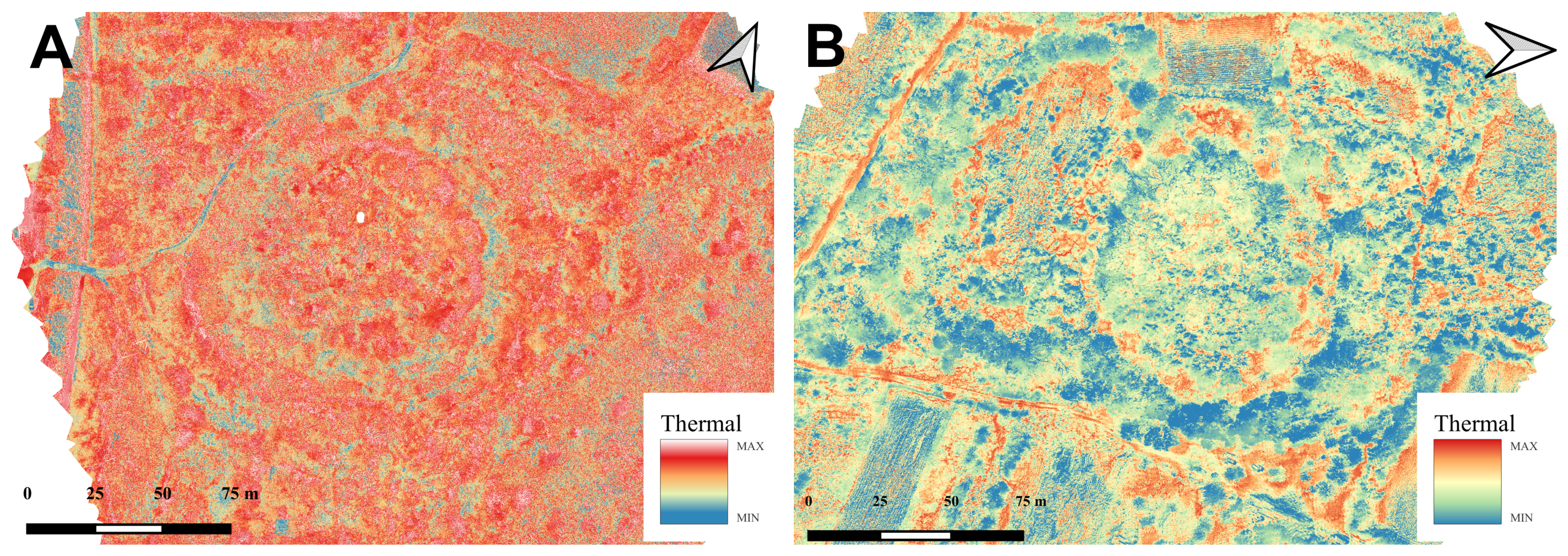
Thermal data were obtained for two sites—Patriketi and Meskheti (Figure 8A,B). In both cases, the distribution of surface temperature shows a correlation with the topography and moisture conditions. Elevated features are generally warmer, whilst ditches and other depressions form cooler zones, which may be linked to greater moisture retention. However, as the source material does not provide absolute temperature values, any comparison between the two sites can only be qualitative in nature (Figure 8A,B).
Figure 8.
Thermal imagery of the archaeological sites: (A) Patriketi and (B) Meskheti.
At Patriketi, the thermal image particularly reflects well the concentric layout of the site. The elevated sections, including the tops of the ramparts, exhibit higher surface temperatures, whilst the moats/ditches appear as continuous, cooler, arched structures. In the western part, there are two broad, parallel zones of low thermal emission, corresponding to watercourses or drainage channels, accompanied by a warmer line marking the dirt track. Within the site, a mosaic of minor thermal anomalies is also visible, associated with variations in the micro-topography, substrate properties and vegetation cover (Figure 8A).
In Meskheti, the most striking contrast is between the warmer elevated areas and the crests of the embankments, and the cooler ring corresponding to the moat or ditch. In addition, linear thermal anomalies associated with roads are evident, as is a regular rectangular feature in the western part of the analyzed area, where the temperature is lower than that of the surrounding terrain. The thermal variation in the north-western part, on the other hand, reflects the historical and contemporary land-use pattern (Figure 8B).
4.4. Differences in the Physical Characteristics of the Archaeological Sites Under Investigation
Measurements of the physical parameters of the mounds, carried out on the basis of DTMs, indicate a marked variation in their size and morphology (Table 4). The largest feature is Patriketi, where the mound covers an area of 4685 m2 and has the largest estimated volume, amounting to 23,425 m3. By comparison, the smallest mound, in Sakulia, has an area of 2754 m2 and a volume of 12,393 m3. The diameter of the mounds ranges from approximately 59 m in Sakulia to approximately 80 m in Patriketi, whilst their height varies relatively little, ranging from 9 to 10 m (Table 4).
Table 4.
Differences in the vertical, horizontal and spatial parameters of the study sites.
Significantly greater differences are observed in the parameters of the moats/ditches. The moat/ditch at Patriketi has the largest area (6520 m2), whilst the site at Sakulia has the smallest (4265 m2). Patriketi also stands out for having the greatest moat/ditch depth, averaging around 5 m, compared with a minimum of around 2 m in Sakulia. The estimated volume of the moats/ditches shows even greater variation—ranging from 5118 m3 in Sakulia to 19,560 m3 in Patriketi (Table 4).
Outer embankments vary more in terms of surface area, width and height. The largest embankment area was recorded in Sakulia (6655 m2), and the smallest in Meskheti (4284 m2). The widest embankment is found in Patriketi (approximately 30 m), whilst the narrowest is in Partskhanakanevi (approximately 18 m). The latter site also features the highest embankment, averaging around 3.5 m, whilst the minimum height of the embankments is around 2 m in Patriketi and Sakulia. In terms of estimated volume, the figures range from 5355 m3 in Meskheti to 8757 m3 in Partskhanakanevi (Table 4).
5. Discussion
5.1. General Remarks
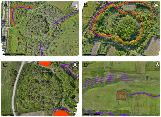
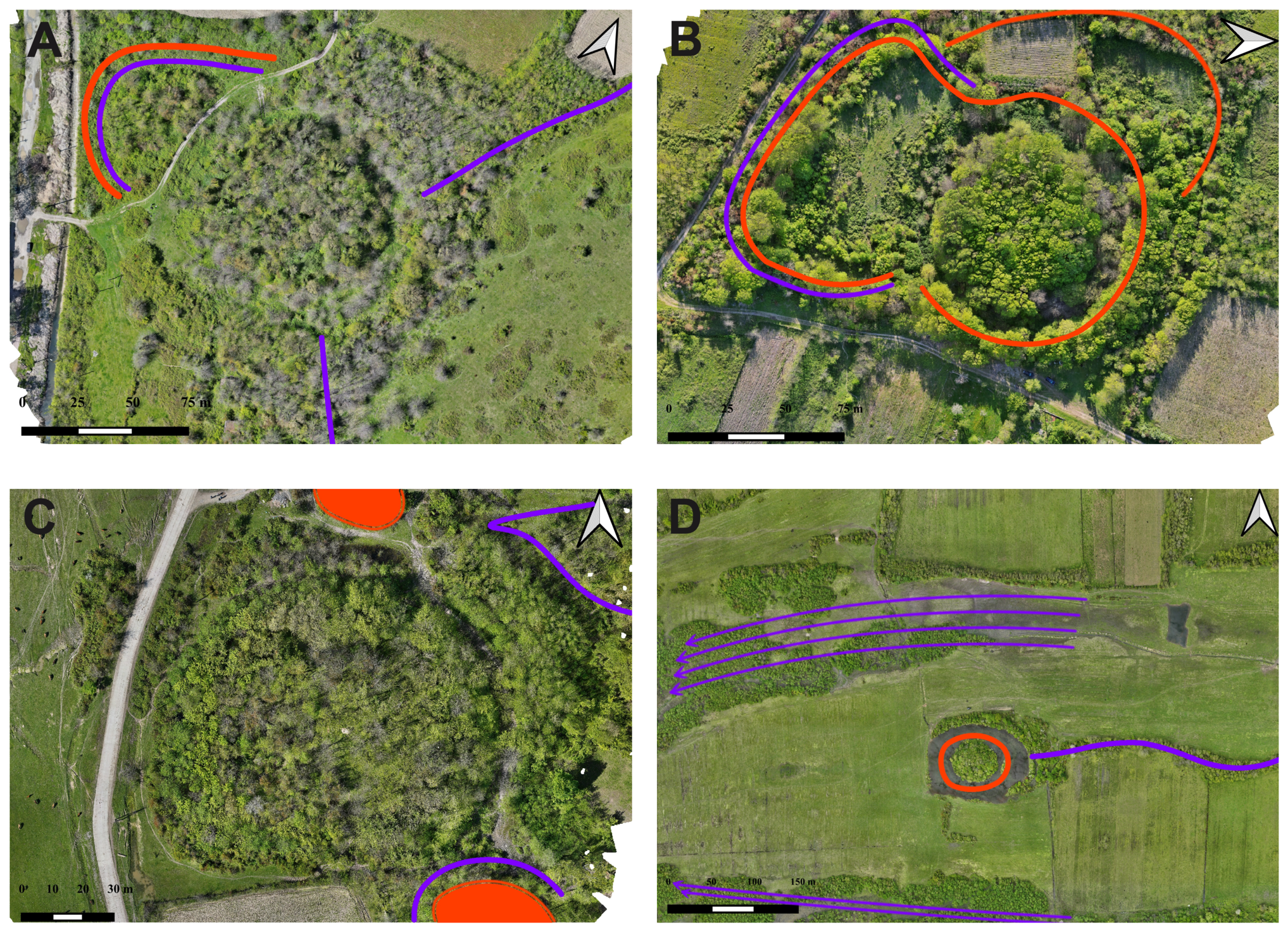
The application of remote sensing, combined with surface surveys, geophysical (ERT) and geoarchaeological investigations, represents a new approach to the study of Type A Colchian settlements within the KLZ area. Partskhanakanevi and Meskheti had not previously been the subject of archaeological research, whilst in Sakulia and Patriketi only isolated trial excavations had been carried out to determine the stratigraphy and preliminary chronology of the sites [55,56,57]. The interdisciplinary approach adopted has not only enabled a more precise understanding of the morphology of the sites but has also identified previously unknown structures related to their spatial organization and hydrographic systems (Figure 9A–D).
Figure 9.
Outlines and spatial distribution of anomalies identified across all UAV-derived datasets at four surveyed archaeological sites: (A) Patriketi, (B) Meskheti, (C) Sakulia, and (D) Partskhanakanevi. Concave anomalies (potential moats, ditches, canals or ancient riverbeds) are highlighted in purple, whereas convex anomalies (potential ramparts, artificial/natural elevations or mounds) are marked in red.
At Partskhanakanevi (Figure 9D), the presence of a moat/ditch surrounding the mound has been confirmed. Remote-sensing data also indicate a heavily eroded embankment and the possible existence of a second line of moat/ditch. To the east, the remains of a canal connected to the moat/ditch system have been identified. Terrain anomalies may also suggest that the site was originally situated much closer to a watercourse or between two riverbeds, even though it is currently located approximately 7 km from the nearest river.
A moat/ditch, which had also been identified during previous geophysical investigation, and geoarchaeological boreholes were confirmed at Sakulia (Figure 9C). Approximately 80 m south-east of the main mound, a small elevation surrounded by a moat/ditch was identified, which may have formed an additional element of the settlement. Another elevation is situated north-east of the mound, and the accompanying depression may be the remains of a canal.
At Patriketi (Figure 9A), a more extensive hydrotechnical system was identified, comprising elements also found at the other sites—moats/ditches and an embankment surrounding the mound. Its most important feature is a canal running towards the modern-day course of the Rioni. Its branches connect with the moat/ditch and partially encircle the site from the east and south-east. Additional depressions to the north and north-east may correspond to canals or former watercourses.
At Meskheti (Figure 9B), a moat/ditch and rampart of the main mound, which had also been investigated by geophysical (ERT) research, and a rampart surrounding the rectangular settlement extension to the south have been confirmed. Remote-sensing data have shown that this area is also surrounded by a previously unidentified moat/ditch, connected to the moat/ditch of the main mound. To the west and north-west of the site, a semi-circular elevation, interpreted as an additional rampart, was also identified, along with a parallel depression, potentially associated with another moat/ditch or canal.
The results of combined research methods confirm the anthropogenic nature of Type A deposits and their close association with local hydrographic systems. The mounds on the Colchis Plain are usually 3–9 m high, with the highest reaching around 10 m; their usable area is typically around 2000–12,000 m2. A characteristic feature is one or two, or more rarely three, lines of moats/ditches, often connected by channels to nearby watercourses. These structures may have served drainage, flood-control, transport, economic and defensive functions [1,15,33,58].
The distribution of the sites also shows a linear pattern, associated with the course of ancient and modern watercourses. In some cases, the main mound is accompanied by smaller satellite features, indicating the agglutinative development of the settlements. A similar pattern has been identified by the KALP team at Maghlaki (KLZ) and, previously, e.g., at Namarnu (E-GZ) [19], which may indicate a transition of parts of the settlement towards a more nucleated spatial structure [6].
The integration of digital elevation models, optical imagery and vegetation indices has proved particularly useful in identifying surface features and anomalies potentially associated with subsurface structures. ExG and EVI2 enable the recognition of crop marks, whilst Z-score standardization facilitates the comparison of their intensity and the identification of local anomalies [59]. Thermal imaging complements this data by recording temperature differences associated, amongst other things, with moisture content, soil properties and the presence of subsurface structures [35,60]. However, the interpretation of processed data requires archaeological context and expert knowledge [35,36].
5.2. Answers to the Research Questions
5.2.1. Remote-Sensing Methods and the Functions of Hills and Changes in Their Land Use over Time
The remote-sensing methods used in the study do not, on their own, allow the function, chronology or changes in land use of the mounds to be determined. Their significance lies primarily in the identification of surface and potentially subsurface features that are difficult to detect, as well as elements located in the vicinity of the main features. This makes it possible to reconstruct the spatial organization of the sites and to pinpoint locations for future investigations more precisely.
However, the anomalies identified require verification through excavation, geophysical and geoarchaeological surveys. Only by integrating these with paleoenvironmental analyses, archaeological materials and absolute dating can we determine the functions of individual structures and changes in the use of the settlements over time.
5.2.2. The Role of Remote Sensing Methods in Identifying Anomalies Associated with Surface and Subsurface Archaeological Features
The remote sensing methods applied in the study effectively aid the identification of anomalies associated with archaeological features by recording their impact on micro-relief, soil properties, moisture content, temperature and vegetation growth. In this way, it is possible to identify distinctive features relating to vegetation, soil, moisture, temperature and micro-relief [61,62,63].
RGB orthophotos enable the identification of differences in soil and vegetation color, as well as minor landforms, whilst multispectral data and vegetation indices reveal changes in plant condition that may remain invisible in standard photographs. UAV studies confirm the effectiveness of such methods in detecting archaeological plant features and the extent of subsurface structures [64,65].
Thermal imaging, on the other hand, provides complementary data, as buried walls, rubble piles, moats/ditches and pits may exhibit different thermal properties from the surrounding ground. Its effectiveness, however, depends on weather conditions, humidity, the time of day and the type of land cover. The best results are therefore achieved by integrating optical, multispectral and thermal data [64,66].
However, anomalies detected by remote sensing cannot automatically be equated with an archaeological feature. Similar signals may result from natural variations in soil, moisture content, land drainage, agricultural activity or modern infrastructure. Anomalies that occur simultaneously in several independent data layers and are confirmed in the field context should be regarded as more reliable.
5.2.3. The Application of Remote Sensing Methods to the Reconstruction of Hydrographic Network Elements and Their Connections to River Systems
The results indicate that remote sensing is particularly useful for reconstructing ancient hydrographic systems associated with Type A settlements. Digital elevation models and vegetation indices enable the identification of ditches, channels and natural depressions based on differences in elevation, moisture content and vegetation condition. Analysis of terrain models can also indicate potential flow directions and connections to local river systems [42].
This is particularly significant in the context of the findings from Patriketi and Partskhanakanevi, where anomalies have been identified that suggest connections between the moats/ditches and canals or former watercourses (Figure 9A,D). At Partskhanakanevi, the interpretation of plant indicators is complicated by the presence of water in the moat/ditch; however, their consistency with the elevation model enhances the reliability of the identified structures (Figure 9D). The plant indicators should be interpreted as an indirect effect of changes in soil properties, water retention and habitat conditions [59].
Nevertheless, the reconstruction of the hydrographic network remains hypothetical, particularly where ancient features have been obliterated by sedimentation, agriculture or modern-day alterations. Verifying requires fieldwork, geoarchaeological and geophysical surveys, as well as sediment analysis.
5.3. Limitations
The effectiveness of remote sensing methods depends on the type and moisture content of the soil, the stage of vegetation growth, lighting conditions, data resolution, and the nature and depth of archaeological features [36,61]. For this reason, remote sensing should be regarded primarily as a prospecting tool, the results of which require verification using other methods [36,37].
Another significant limitation of research at KLZ is the specific nature of local soil and environmental conditions. Tests carried out between 2021 and 2024 demonstrated the limited effectiveness of ground-penetrating radar and selected magnetic methods. The best results were obtained using electrical resistivity tomography (ERT) in a dipole–dipole configuration, which enabled penetration to a depth of approximately 4.5–7.5 m and the identification of the geometry and depth of pits and ditches. Limitations also apply to hand-drilling: on hilltops, the presence of boulder material limits drilling depth to around 1 m, whilst better results are obtained on slopes and in moat/ditch areas.
Another key factor is the season in which the data is collected. The visibility of plant features depends on the phenological phase and the density of the vegetation, and dense tree canopies may limit the ability to observe the ground using passive methods [67,68]. Under such conditions, ALS/LiDAR offers greater potential, as it allows for partial penetration of the vegetation cover, particularly during flights carried out during the leafless season [45]. The most significant challenge, therefore, remains not the acquisition of data itself, but its integration with the archaeological context of the site and the results of other research methods [69].
5.4. Future Research
Further research should focus on verifying the identified anomalies and unifying the dataset across all sites. It will be particularly important to acquire UAV-ALS/UAV-LiDAR data, especially for features covered by dense vegetation, and to supplement the research so that each site is recorded using a comparable set of sensors.
The second approach should involve multi-temporal remote sensing analyses, incorporating data collected at different times of the year and across successive years. Variations in phenology and moisture conditions may mean that crop marks are only visible during specific periods. Multi-temporal analyses can therefore increase the likelihood of detecting subtle structures and reduce the risk of misinterpreting anomalies resulting from temporary environmental conditions. Remote sensing should, however, remain a tool for prospecting and planning further research, rather than a standalone method for determining the nature and chronology of sites [63,70].
Another promising avenue is the implementation of artificial intelligence and machine learning methods to analyze orthophoto maps of Georgia and automatically identify areas with high archaeological potential. These solutions should be developed on the basis of field-verified sites, which can serve as reference data for future predictive models.
6. Conclusions
Integrated research into four Type A Colchian settlements—Patriketi, Meskheti, Sakulia and Partskhanakanevi—has provided new data on their morphology, spatial organization and relationship with local hydrographic systems. Of particular significance is the investigation of Partskhanakanevi and Meskheti, which had not previously been the subject of archaeological research, and the expansion of the hitherto limited knowledge regarding Sakulia and Patriketi. The findings thus fill a significant gap in research into Colchian settlement during the Bronze and Iron Ages in the eastern part of the Colchian Plain.
All studied sites share a common spatial layout comprising a central artificial mound, a moat/ditch and a rampart, whilst their parameters vary considerably. The surface area of the mounds ranges from 2754 to 4685 m2, their diameter is approximately 59–80 m, and their height is 9–10 m. The moats/ditches cover an area of 4265–6520 m2, reach an average depth of 2–5 m and have a volume of 5118–19,560 m3, whilst the height of the ramparts is approximately 2–3.5 m. These data confirm the anthropogenic nature of the sites and indicate the varied scale of the land alterations.
Remote sensing has revealed previously unknown aspects of the layout of the sites, indicating that some of the settlements were more complex than previous surveys had suggested. Among other things, additional moats/ditches and canals in Partskhanakanevi; a satellite feature approximately 80 m from the main mound in Sakulia; an extensive system of canals connecting the moat/ditch to the course of the modern Rioni riverbed in Patriketi; and a previously unrecognized moat/ditch around the southern extension of the settlement in Meskheti. Partskhanakanevi is of particular significance; it is currently situated approximately 7 km from the nearest river, where relict landforms suggest a possible much closer connection between the settlement and the ancient hydrographic network.
The results indicate a close spatial relationship between Type A settlements and the aquatic environment of the Colchian Plain. The identified ditches, canals, former riverbeds and depressions in the terrain suggest that water management may have been a significant aspect of the organization of these sites. However, remote-sensing data do not allow for a definitive conclusion as to whether these structures served drainage, flood-control, transport, economic or defensive functions; therefore, their interpretation requires further archaeological and geoarchaeological verification.
The integration of elevation models, RGB imagery, ExG and EVI2 indices, and thermal data confirmed the high effectiveness of UAV remote sensing in identifying micro-relief, as well as vegetation, moisture and thermal anomalies associated with potential archaeological structures. The greatest interpretative reliability is ensured by the consistency of anomalies occurring across several independent data layers. Remote sensing therefore enables the effective identification of the spatial organization of sites and the reconstruction of elements of ancient hydrographic systems, but does not, on its own, allow for the determination of their functions, chronology or changes in land use over time.
The novelty of this study lies in the application of an integrated approach combining high-resolution UAV remote sensing, photogrammetry, surface survey, geophysics and geoarchaeology to poorly understood Type A Colchis settlements in a challenging wetland environment. This approach provides a useful model for the non-invasive survey of similar sites; however, its effectiveness depends, amongst other factors, on weather conditions, humidity, the vegetation phase and tree cover. Further research should focus on verifying the anomalies detected through excavations, geophysical and geoarchaeological surveys, absolute dating and paleoenvironmental reconstructions, as well as on the use of ALS/LiDAR and multi-temporal UAV data.
Author Contributions
Conceptualization, J.H., W.K. and D.K.; methodology, M.S., P.B., J.H., W.K. and L.Ł.; software, M.S. and P.B.; validation, J.H., W.K. and D.K.; formal analysis, M.S., P.B., W.K. and J.H.; investigation, M.S., P.B., J.H. and L.Ł.; resources, M.S., P.B., L.Ł. and J.H.; data curation, M.S. and P.B.; writing—original draft preparation, M.S., P.B., J.H., L.Ł., W.K. and D.K.; writing—review and editing, D.K., W.K., M.S., P.B., J.H. and L.Ł.; visualization, M.S., P.B. and W.K.; supervision, D.K., W.K. and J.H.; project administration, D.K., W.K. and J.H.; funding acquisition, J.H. and D.K. All authors have read and agreed to the published version of the manuscript.
Funding
This research received no external funding.
Data Availability Statement
The original contributions presented in the study are included in the article. Further inquiries can be directed to the corresponding author.
Acknowledgments
The research was carried out under an agreement between the Krukowski Polish-Georgian Interdisciplinary Research Center (KIRC) and Maria Curie-Skłodowska University (MCSU), and was funded by both institutions. Sincere appreciation is also extended to the Polish Institute in Tbilisi and the Embassy of the Republic of Poland to Georgia for contributing financial resources toward all scientific projects undertaken by the KIRC and its partners. The authors would like to thank Roland Isakadze (National Agency for Cultural Heritage Preservation of Georgia, Akaki Tsereteli State University) and Shalva Buadze (Niko Berdzenishvili Kutaisi State Historical Museum, Akaki Tsereteli State University) for their substantive and logistical support and technical assistance. The authors wish to express their gratitude to the staff of the Kutaisi Historical-Architectural Museum-Reserve for their exceptional dedication. Their invaluable expertise and assistance were instrumental to the success of this initiative.
Conflicts of Interest
The authors declare no conflicts of interest.
References
- Khoshtaria, N. Диха-Гудзуба; Древнее Население Кoлхидскoй Низменнoсти [Dikha Gudzuba: Ancient Population of Colchis Lowland]. Сooбщения Академии Наук Грузинскoй ССР [Bull. Acad. Sci. Georgian SSR] 1944, 5, 207–216. [Google Scholar]
- Kilanava, B. დიხაგუძუბა. კოლხეთის უძველესი დასახლებები. შერჩეული კვლევები [Dikhagudzuba—The Ancient Settlements of Colchis. Selected Studies]; Merani Publishing: Tbilisi, Georgia, 2009. [Google Scholar]
- Janelidze, Z.; Tatashidze, Z. საქართველოს შავიზღვისპირა ჭაობების არქეოლოგიური ძეგლების პალეოგეოგრაფიული ინტერპრეტაცია [Palaeogeographical Interpretation of Archaeological Sites of Swamps of the Black Sea Coast of Georgia]. Bull. Georgian Natl. Acad. Sci. 2010, 4, 159–161. [Google Scholar]
- Papuashvili, R.; Papuashvili, I. კოლხეთის დაბლობი შავი ზღვის პალეორეჟიმის ფონზე (ძვ. წ. III-I ათასწლეულებში) [Colchian Lowland in the Context of the Black Sea Palaeoregime (III-I Millennium BCE)]; Meridiani Publishing: Tbilisi, Georgia, 2014. [Google Scholar]
- Laermanns, H. A Palaeogeographic and Geoarchaeologic Study on the Colchian Plain Along the Black Sea Coast of Georgia. Doctoral Dissertation, Universität zu Köln, Köln, Germany, 2018. [Google Scholar]
- Hamburg, J.; Lorenzon, M. Before Meeting the Greeks: Kutaisi Influence in Late Bronze and Early Iron Age Colchian Settlements. J. Field Archaeol. 2022, 47, 13–31. [Google Scholar] [CrossRef] [Scilit]
- Jibladze, L.; Papuashvili, R. ხელოვნურ ბორცვთა აგებულებისათვი [Structure of Artificial Mounds]; Georgian National Museum: Tbilisi, Georgia, 2013. [Google Scholar]
- Hamburg, J.; Isakadze, R. Preliminary Report of 2017 Polish-Georgian Archaeological Expedition at Gabashvili Hill and Its Surroundings Area (Kutaisi, Western Georgia). Pro Ga. J. Kartvelological Stud. 2018, 28, 137–156. [Google Scholar]
- Hamburg, J.; Badura, M.; Bieńkowski, R.; Kaliszewska, A.; Skrzyński, G. Preliminary Results of Archaeological and Archaeobotanical Investigation of the Defensive Moat Found in Kutaisi (Western Georgia). Pro Ga. J. Kartvelological Stud. 2019, 29, 43–62. [Google Scholar]
- Lanchava, O.; Isakadze, R.; Hamburg, J.; Buadze, S.; Bubuteishvili, T.; Bieńkowski, R.; Kaliszewska, A. Report on Archaeological Research Conducted in Kutaisi by the Georgian-Polish Expedition (Season 2023). Scienfitic-Res. J. Andria Apakidze Inst. Archaeol. Eur. Univ. 2024, 10, 106–125. [Google Scholar]
- Mikeladze, T. ძიებანი კოლხეთისა და სამხრეთ-აღმოსავლეთ შავიზღვისპირეთის უძველესი მოსახლეობის ისტორიიდან [Studies from the History of the Ancient Population of Colchis and the Southeastern Black Sea Coast]; Georgian National Academy of Sciences location: Tbilisi, Georgia, 1974. [Google Scholar]
- Gogadze, E. კოლხეთის ბრინჯაოსა და ადრეული რკინის ხანის ნამოსახლართა კულტურა [Culture of the Bronze and Early Iron Age Settlements of Colchis]; Metsniereba: Tbilisi, Georgia, 1982. [Google Scholar]
- Gabelia, A. Пoселения Кoлхидскoй Культуры (На Материалах Абхазии) [Settlements of the Colchian Culture (Based on the Materials from Abkhazia)]; Merani Publishing: Moscow, Russia, 1984. [Google Scholar]
- Laermanns, H.; Kirkitadze, G.; May, S.M.; Kelterbaum, D.; Opitz, S.; Heisterkamp, A.; Basilaia, G.; Elashvili, M.; Brückner, H. Bronze Age settlement mounds on the Colchian plain at the Black Sea coast of Georgia: A geoarchaeological perspective. Geoarchaeology 2018, 33, 453–469. [Google Scholar] [CrossRef] [Scilit]
- Kuftin, B. Материалы к Археoлoгии Кoлхиды [Materials on the Archaeology of Colchis]; Metsniereba: Tbilisi, Georgia, 1950; Volume 2. [Google Scholar]
- Trapsh, M. Памятники Кoлхидскoй Культуры в Селе Куланурхва Абхазскoй АССР [Monuments of Colchian Culture in the Village of Kulanurkhva, Abkhaz SSR]. Сбoрник Материалoв Пo Археoлoгии Кавказа [Collect. Pap. Archaeol. Cauc.] 1962, 12, 90–105. [Google Scholar]
- Lordkipanidze, G. Кoлхида в VI–II Вв. Дo н. э. [Colchis in the 6th–2nd Centuries BC]; Metsniereba: Tbilisi, Georgia, 1968. [Google Scholar]
- Grigolia, G. დასავლეთ საქართველოს არქეოლოგიური ექსპედიციის 1969 წლის მუშაობის შედეგები [The Results of the 1969 Fieldwork of the West Georgian Archaeological Expedition]. Არქეოლოგიური Კვლევა-Ძიება Საქართველოში [Archaeol. Res. Ga.] 1972, 18–20. [Google Scholar]
- Grigolia, G. ბარბაროსების დიდი ქალაქის ლოკალიზაციისათვი [For the Localization of the Great City of the Barbarians]. Ძეგლის Მეგობარი [Dzeglis Megob.] 1973, 33, 50–58. [Google Scholar]
- Mikeladze, T. არქეოლოგიური კვლევა-ძიება რიონის ქვემო წელზე [Archaeological Research on the Lower Reaches of the Rioni River]; Metsniereba: Tbilisi, Georgia, 1978. [Google Scholar]
- Apakidze, J. Центральная Кoлхида в Эпoху Пoздней Брoнзы—Раннегo Железа [Central Colchis in the Late Bronze—Early Iron Age]; Археoлoгические исследoвания в Грузии [Archaeological Research in Georgia]; Metsniereba: Tbilisi, Georgia, 1980; Volume 3, p. 40. [Google Scholar]
- Japaridze, O. დასავლეთ საქართველო გვიან ბრინჯაოს ხანაში [Western Georgia in the Late Bronze Age]. Მაცნე—ისტორიის. Არქეოლოგიის. Ეთნოგრაფიისა Და Ხელოვნების Ისტორიის Სერია [Matsne—Ser. Hist. Archaeol. Ethnogr. Art Hist.] 1982, 1, 61–82. [Google Scholar]
- Mikeladze, T.; Khakhutaishvili, D. Древнекoлхидскoе Пoселение Намчедури [Ancient Colchian Settlement of Namcheduri]; Metsniereba: Tbilisi, Georgia, 1985. [Google Scholar]
- Chavleishvili, I. არქეოლოგიური გათხრები ფიჭვნარის უძველეს ნამოსახლარზე 1983 წელს [Archaeological Excavations at the Ancient Settlement of Pichvnari in 1983]. Сбoрник данных пo древнoстям Закавказья (СДДЗ) [Collect. Data Antiq. Transcaucasia (SDDZ)] 1987, XVI, 21–33. [Google Scholar]
- Baramidze, M.; Chigoshvili, T.; Pkhakadze, G.; Jibladze, L.; Makharadze, E.; Sherazadishvili, B. Рабoты Археoлoгических Экспедиций Абхазии в 1984–1985 Гг. [Archaeological Expeditions in Abkhazia in 1984–1985]; Metsniereba: Tbilisi, Georgia, 1987. [Google Scholar]
- Baramidze, M.; Jibladze, L. Le Site de Pičori: Chronologie et Périodisation Des Âges Du Bronze et Du Fer. In Sur les Traces des Argonautes. Actes du 6e Symposium de Vani (Colchide), 22–29 Septembre 1990; Presses Universitaires de Franche-Comté/Les Belles Lettres: Paris, France, 1996; pp. 341–345. [Google Scholar]
- Papuashvili, R. არქეოლოგიური გათხრები ხულევში (1999–2001): ურბანიზმი შავისპირეთში არქაული და კლასიკური ხანაში. თბილისი [Archaeological Excavations in Khulevi (1999–2001): Urbanism in the Black Sea Coastal Region in the Archaic and Classical Periods]; Metsniereba: Tbilisi, Georgia, 2002. [Google Scholar]
- Papuashvili, R.; Papuashvili, N. კოლხეთის ძველი ნამოსახლარები ერგეტა [Ancient Colchian Settlement in the Village Ergeta]; Meridiani Publishing: Tbilisi, Georgia, 2005. [Google Scholar]
- Muskhelishvili, D.; Murvanidze, B.; Jibladze, L. The Middle Bronze Age Settlement at Anaklia II. In Archaeology in Southern Caucasus: Perspectives from Georgia; Sagona, A., Abramishvili, M., Eds.; Peeters: Leuven, Belgium, 2008; Volume 19, pp. 270–278. [Google Scholar]
- Muskhelishvili, D.; Jibladze, L.; Papuashvili, R.; Papuashvili, N. ანაკლია მეორე [Anaklia Meore]; Meridiani Publishing: Tbilisi, Georgia, 2010. [Google Scholar]
- Laermanns, H.; Elashvili, M.; Kirkitadze, G.; Loveluck, C.; May, S.; Kelterbaum, D.; Papuashvili, R.; Brückner, H. The Bronze Age Occupation of the Black Sea Coast of Georgia—New Insights from Settlement Mounds of the Colchian Plain. Geoarchaeology 2024, 39, 335–350. [Google Scholar] [CrossRef] [Scilit]
- Mörtz, T.; Chabashvili, L.; Apakidze, J.; Hansen, S.; Heussner, K.-E. Dating Tabakoni: The Chronology of a Bronze Age Settlement Mound in Colchis. Antiquity 2026, 100, 56–74. [Google Scholar] [CrossRef] [Scilit]
- Jibladze, L. კოლხეთის დაბლობის ძველი წელთაღრიცხვის III–II ათასწლეულების ნამოსახლარები [Settlements of the Colchian Plain of the 3rd–2nd Millennia BC]; Meridiani Publishing: Tbilisi, Georgia, 2005. [Google Scholar]
- Lasaponara, R.; Masini, N. Satellite remote sensing in archaeology: Past, present and future perspectives. J. Archaeol. Sci. 2011, 38, 1995–2002. [Google Scholar] [CrossRef] [Scilit]
- Adamopoulos, E.; Rinaudo, F. UAS-Based Archaeological Remote Sensing: Review, Meta-Analysis and State-of-the-Art. Drones 2020, 4, 46. [Google Scholar] [CrossRef] [Scilit]
- Casana, J. Rethinking the Landscape: Emerging Approaches to Archaeological Remote Sensing. Annu. Rev. Anthropol. 2021, 50, 167–186. [Google Scholar] [CrossRef] [Scilit]
- Opitz, R.; Herrmann, J. Recent Trends and Long-Standing Problems in Archaeological Remote Sensing. J. Comput. Appl. Archaeol. 2018, 1, 19–41. [Google Scholar] [CrossRef] [Scilit]
- Stanjek, H.; Fassbinder, J.W.E. Soil Aspects Affecting Archaeological Details in Aerial Photographs. Archaeol. Prospect. 1995, 2, 91–101. [Google Scholar] [CrossRef] [Scilit]
- Agapiou, A. Detection of Archaeological Crop Marks by Using Satellite QuickBird Multispectral Imagery. J. Archaeol. Sci. 2007, 34, 214–221. [Google Scholar] [CrossRef] [Scilit]
- Kaimaris, D. Aerial Remote Sensing Archaeology—A Short Review and Applications. Land 2024, 13, 997. [Google Scholar] [CrossRef] [Scilit]
- Doneus, M.; Briese, C.; Fera, M.; Janner, M. Archaeological Prospection of Forested Areas Using Full-Waveform Airborne Laser Scanning. J. Archaeol. Sci. 2008, 35, 882–893. [Google Scholar] [CrossRef] [Scilit]
- Doneus, M. Openness as Visualization Technique for Interpretative Mapping of Airborne Lidar Derived Digital Terrain Models. Remote Sens. 2013, 5, 6427–6442. [Google Scholar] [CrossRef] [Scilit]
- Chase, A.F.; Chase, D.Z.; Weishampel, J.F.; Drake, J.B.; Shrestha, R.L.; Slatton, K.C.; Awe, J.J.; Carter, W.E. Airborne LiDAR, Archaeology, and the Ancient Maya Landscape at Caracol, Belize. J. Archaeol. Sci. 2011, 38, 387–398. [Google Scholar] [CrossRef] [Scilit]
- Bewley, R.H.; Crutchley, S.P.; Shell, C.A. New Light on an Ancient Landscape: Lidar Survey in the Stonehenge World Heritage Site. Antiquity 2005, 79, 636–647. [Google Scholar] [CrossRef] [Scilit]
- Doneus, M.; Banaszek, Ł.; Verhoeven, G.J. The Impact of Vegetation on the Visibility of Archaeological Features in Airborne Laser Scanning Datasets from Different Acquisition Dates. Remote Sens. 2022, 14, 858. [Google Scholar] [CrossRef] [Scilit]
- Nex, F.; Remondino, F. UAV for 3D Mapping Applications: A Review. Appl. Geomat. 2014, 6, 1–15. [Google Scholar] [CrossRef] [Scilit]
- Colomina, I.; Molina, P. Unmanned Aerial Systems for Photogrammetry and Remote Sensing: A Review. ISPRS J. Photogramm. Remote Sens. 2014, 92, 79–97. [Google Scholar] [CrossRef] [Scilit]
- Gonzalez-Piqueras, J.; Jara, F.; Lopez, H.; Villodre, J.; Hernandez, D.; Calera, A.; Lopez-Urrea, R.; Sanchez, J. Determining Crop Phenology for Different Varieties of Barley and Wheat on Intensive Plots Using Proximal Remote Sensing; Neale, C., Maltese, A., Eds.; SPIE: Strasbourg, France, 2019; Volume 111490H, pp. 140–152. [Google Scholar] [CrossRef] [Scilit]
- Chiabrando, F.; Nex, F.; Piatti, D.; Rinaudo, F. UAV and RPV Systems for Photogrammetric Surveys in Archaeological Areas: Two Tests in The Piedmont Region (Italy). J. Archaeol. Sci. 2011, 38, 697–710. [Google Scholar] [CrossRef] [Scilit]
- Agapiou, A. Remote Sensing Heritage in a Petabyte-Scale: Satellite Data and UAV for Archaeological Prospection. J. Archaeol. Sci. Rep. 2020, 33, 102509. [Google Scholar] [CrossRef] [Scilit]
- Woebbecke, D.M.; Meyer, G.E.; Von Bargen, K.; Mortensen, D.A. Color Indices for Weed Identification under Various Soil, Residue, and Lighting Conditions. Trans. ASAE 1995, 38, 259–269. [Google Scholar] [CrossRef] [Scilit]
- Huete, A.; Didan, K.; Miura, T.; Rodriguez, E.P.; Gao, X.; Ferreira, L.G. Overview of the Radiometric and Biophysical Performance of the MODIS Vegetation Indices. Remote Sens. Environ. 2002, 83, 195–213. [Google Scholar] [CrossRef] [Scilit]
- Fotheringham, A.S.; Charlton, M.; Brunsdon, C. Quantitative Geography: Perspectives on Spatial Data Analysis; SAGE Publications: London, UK, 2000. [Google Scholar] [CrossRef] [Scilit]
- Shatashvili, L.K.; Sikharulidze, D.; Khazaradze, N. Dynamics of Changes in the IMF Sector Structure in the Vicinity of the Earth and the Problem of Earthquakes. Int. J. Geomagn. Aeron. 2000, 1. [Google Scholar]
- Japaridze, O. არდციხის არქეოლოგიური ექსპედიციის მუშაობის შესახებ ვარდციხჰესის მშენებლობის ზონაში [On the Work of the Vartsikhe Archaeological Expedition in the Vartsikhe HES Construction Zone]. Ძეგლის Მეგობარი [Dzeglis Megob.] 1975, 39, 30–34. [Google Scholar]
- Kalandadze, K.; Bugianishvili, T.; Ioseliani, N.; Jikia, M.; Kalandadze, N. Archäologische Expedition in Zkaltubo. In აველე არქეოლოგიური კვლევა-ძიება 1989–1992 წლებში (მოკლე ანგარიშები) [Field Archaeological Research in 1989–1992 (Brief Reports)]; Nioradze, M., Ed.; Georgian National Academy of Sciences, Georgian National Museum: Tbilisi, Georgia, 2004; pp. 18–19. [Google Scholar]
- Apakidze, J. Towards the Study of Late Bronze and Early Iron Age Settlements and Settlement Systems of the Colchian Culture in Western Georgia. Archäologische Mitteilungen Aus Iran Turan 2005, 37, 175–187. [Google Scholar]
- Apakidze, J.; Hansen, S.; Mörtz, T.; Tchabašvili, L. Vorbericht Über Die Archäologischen Ausgrabungen Des Künstlichen Siedlungshügels Der Kolchis-Kultur von Tabakoni in Westgeorgien. In Der Kaukasus Zwischen Osteuropa und Vorderem Orient in der Bronze- und Eisenzeit: Dialog der Kulturen. Kultur des Dialogs; Kashuba, M.T., Reinhold, S., Piotrovsky, J.J., Eds.; Gebr. Mann Verlag: Berlin, Germany, 2020; Volume 19, pp. 457–475. [Google Scholar]
- Agapiou, A.; Hadjimitsis, D.G.; Alexakis, D.D. Evaluation of Broadband and Narrowband Vegetation Indices for the Identification of Archaeological Crop Marks. Remote Sens. 2012, 4, 3892–3919. [Google Scholar] [CrossRef] [Scilit]
- Casana, J.; Wiewel, A.; Cool, A.; Hill, A.C.; Fisher, K.D.; Laugier, E.J. Archaeological Aerial Thermography in Theory and Practice. Adv. Archaeol. Pract. 2017, 5, 310–327. [Google Scholar] [CrossRef] [Scilit]
- Lasaponara, R.; Masini, N. Remote Sensing in Archaeology: From Visual Data Interpretation to Digital Data Manipulation. In Satellite Remote Sensing; Lasaponara, R., Masini, N., Eds.; Remote Sensing and Digital Image Processing; Springer: Dordrecht, The Netherlands, 2012; Volume 16, pp. 3–16. ISBN 978-90-481-8800-0. [Google Scholar]
- Luo, X.; Chen, X.; Xu, L.; Myneni, R.; Zhu, Z. Assessing Performance of NDVI and NDVI3g in Monitoring Leaf Unfolding Dates of the Deciduous Broadleaf Forest in Northern China. Remote Sens. 2013, 5, 845–861. [Google Scholar] [CrossRef] [Scilit]
- Lindsay, I.; Mkrtchyan, A. Free and Low-Cost Aerial Remote Sensing in Archaeology: An Overview of Data Sources and Recent Applications in the South Caucasus. Adv. Archaeol. Pract. 2023, 11, 164–183. [Google Scholar] [CrossRef] [Scilit]
- Agudo, P.U.; Pajas, J.A.; Pérez-Cabello, F.; Redón, J.V.; Lebrón, B.E. The Potential of Drones and Sensors to Enhance Detection of Archaeological Cropmarks: A Comparative Study Between Multi-Spectral and Thermal Imagery. Drones 2018, 2, 29. [Google Scholar] [CrossRef] [Scilit]
- Materazzi, F.; Pacifici, M. Archaeological Crop Marks Detection through Drone Multispectral Remote Sensing and Vegetation Indices: A New Approach Tested on the Italian Pre-Roman City of Veii. J. Archaeol. Sci. Rep. 2022, 41, 103235. [Google Scholar] [CrossRef] [Scilit]
- Salgado Carmona, J.Á.; Quirós, E.; Mayoral, V.; Charro, C. Assessing the Potential of Multispectral and Thermal UAV Imagery from Archaeological Sites. A Case Study from the Iron Age Hillfort of Villasviejas Del Tamuja (Cáceres, Spain). J. Archaeol. Sci. Rep. 2020, 31, 102312. [Google Scholar] [CrossRef] [Scilit]
- Verhoeven, G. Are We There Yet? A Review and Assessment of Archaeological Passive Airborne Optical Imaging Approaches in the Light of Landscape Archaeology. Geosciences 2017, 7, 86. [Google Scholar] [CrossRef] [Scilit]
- Verhoeven, G.; Doneus, M. Balancing on the Borderline—A Low-cost Approach to Visualize the Red-edge Shift for the Benefit of Aerial Archaeology. Archaeol. Prospect. 2011, 18, 267–278. [Google Scholar] [CrossRef] [Scilit]
- Kadhim, I.; Abed, F.M. A Critical Review of Remote Sensing Approaches and Deep Learning Techniques in Archaeology. Sensors 2023, 23, 2918. [Google Scholar] [CrossRef] [Scilit] [PubMed]
- Luo, L.; Wang, X.; Liu, J.; Zheng, W.; Zhen, J.; Zhu, L.; Liu, C.; Wan, H. Low-Cost Archaeological Investigation and Rapid Mapping of Ancient Stone Tidal Weirs in the Penghu Archipelago Using Google Earth. Sustainability 2019, 11, 4536. [Google Scholar] [CrossRef] [Scilit]

Disclaimer/Publisher’s Note: The statements, opinions and data contained in all publications are solely those of the individual author(s) and contributor(s) and not of MDPI and/or the editor(s). MDPI and/or the editor(s) disclaim responsibility for any injury to people or property resulting from any ideas, methods, instructions or products referred to in the content. |
© 2026 by the authors. Licensee MDPI, Basel, Switzerland. This article is an open access article distributed under the terms and conditions of the Creative Commons Attribution (CC BY) license.