


Highlights
What are the main findings?
- Terrace aggradation occurred mainly during MIS 3c (ca. 50 ka), MIS 3a (ca. 35–27 ka), and early MIS 1 (ca. 11 ka) in the Turpan fold–thrust belt (FTB), broadly corresponding to relatively humid intervals recorded in regional paleoclimate records.
What are the implications of the main findings?
- Climate controlled the timing of terrace aggradation and abandonment, whereas tectonic uplift enhanced river incision and terrace preservation in the Turpan FTB.
Abstract
Fluvial terraces provide important archives for understanding the relative roles of tectonics and climate in landscape evolution. Here, we investigate late Quaternary fluvial terraces in the tectonically active Turpan fold–thrust belt (FTB) of the eastern Tianshan using geomorphic surveys, unmanned aerial vehicle (UAV)-derived topography, and optically stimulated luminescence (OSL) dating. Our results show that terrace aggradation occurred mainly during marine isotope stage (MIS) 3c (ca. 50 ka), MIS 3a (ca. 35–27 ka), and early MIS 1 (ca. 11 ka), broadly corresponding to relatively humid intervals documented in regional paleoclimate records, suggesting that the aggradation and abandonment of fluvial terraces in the Turpan FTB were mainly driven by climate-induced changes in the Qs/Qw ratio. Previous studies show that tectonic deformation enhanced the magnitude of river incision in the central Turpan FTB. Combined with regional paleoclimate records and the tectonic activity, we suggest that climate-induced changes in hydrological conditions control the timing of terrace aggradation and subsequent abandonment, whereas tectonic uplift may influence the magnitude of river incision and promote the long-term preservation of terraces in the Turpan FTB.
1. Introduction
Numerous studies have demonstrated that tectonic activity and climate fluctuations are the primary factors controlling landscape evolution [1,2,3,4,5]. Changes in either tectonic or climatic conditions can perturb fluvial systems, leading to alternating phases of incision and lateral planation that lead to the formation of fluvial terraces [4,6,7,8]. Tectonic activity can increase channel gradients and stream power and reorganize drainage systems through mountain uplift, slope modification, and divide migration [9,10], whereas climate fluctuations influence fluvial geomorphic processes by modulating sediment supply and water discharge [2,8,11,12,13]. Whether changes in tectonics or climate drive the evolution of river systems is one of the core scientific issues in geomorphological research [2,4], particularly given the strong interactions and feedbacks between these factors [14]. Fluvial terraces are common and important river landforms that represent relict floodplains [1,4,6]. Because they preserve evidence of past river dynamics, fluvial terraces have been widely used to reconstruct changes in regional climate and tectonics [1,4,6,13,15,16,17,18,19,20,21,22,23,24]. However, the relative roles of climatic variations versus tectonic activity in the formation of stepped fluvial terraces remain debated [13,20]. Fluvial terraces in tectonically active regions are particularly sensitive to even minor environmental changes and therefore provide valuable constraints on the influence of climate on terrace formation [4].
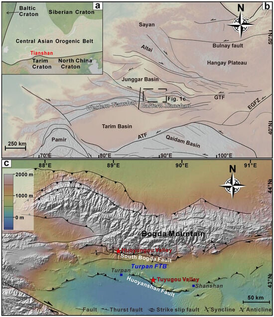
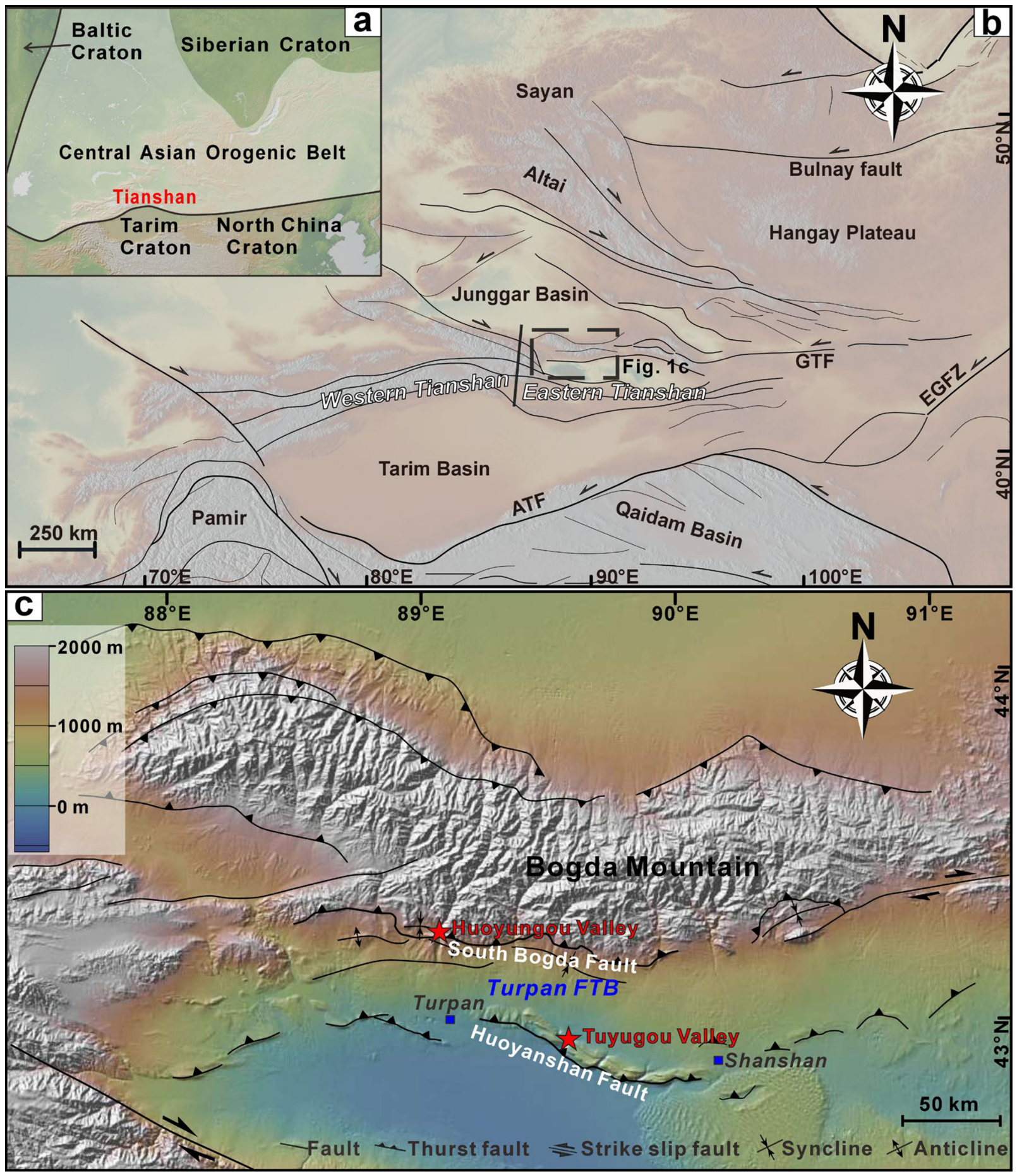
The Tianshan orogenic belt, situated along the southern margin of the Central Asian Orogenic Belt, is one of the largest intracontinental orogenic belts, extending approximately 2500 km from east to west [25,26] (Figure 1a). It has been one of the most actively deforming intracontinental orogenic belts during the Cenozoic, driven by the far-field effects of the India–Asia collision, as documented by GPS measurements [27,28], low-temperature thermochronology [29,30,31], and sedimentary records [32,33,34,35]. The Chinese Tianshan can be divided into the eastern and the western Tianshan, roughly separated at 88°E (Figure 1b). The highest point (Bogda Peak) reaches 5445 m, whereas the lowest intermontane basin (Turpan Basin) lies at −154 m. Together with the Turpan fold–thrust belt (FTB), this topographic relief reflects significant Cenozoic deformation in the eastern Tianshan (Figure 1c). A recent study integrating low-temperature thermochronology and growth-strata analysis revealed that deformation along the South Bogda Fault initiated at ~30 Ma, and subsequently propagated southward to the Huoyanshan Fault in the central Turpan Basin at ~10 Ma [36]. Quaternary deformation along the Huoyanshan Fault has further intensified, with shortening rates reaching 2–3 mm yr−1 [37]. Therefore, the Turpan FTB, defined as the zone between the South Bogda Fault and the Huoyanshan Fault along the southern front of the Bogda Mountains, is one of the most tectonically active regions in the eastern Tianshan [36,37].
Figure 1.
(a,b) Simplified geological maps showing the locations of the eastern Tianshan (modified from Li et al. [25] and Chen et al. [26]). (c) Topographic map of the eastern Tianshan Mountains showing the major tectonic elements and the study area (www.geomapapp.org). Red stars indicate the location of the study area, including Huoyungou and Tuyugou valleys.
Although the Turpan Basin is one of the most arid regions on Earth, the Tianshan Mountains, which act as the water tower of Central Asia, supply meltwater to the basin, sustaining several rivers that cross the Turpan FTB [38]. The preserved fluvial terraces in this region provide a natural laboratory for deciphering climatic influences on river systems in tectonically active regions. In this study, we establish the geomorphic and chronological framework and investigate the mechanisms driving the formation of fluvial terraces along rivers crossing the frontal thrust system of the eastern Tianshan, northwestern China.
2. Geological Setting
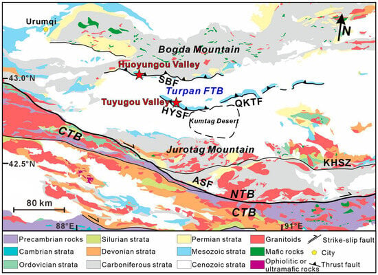
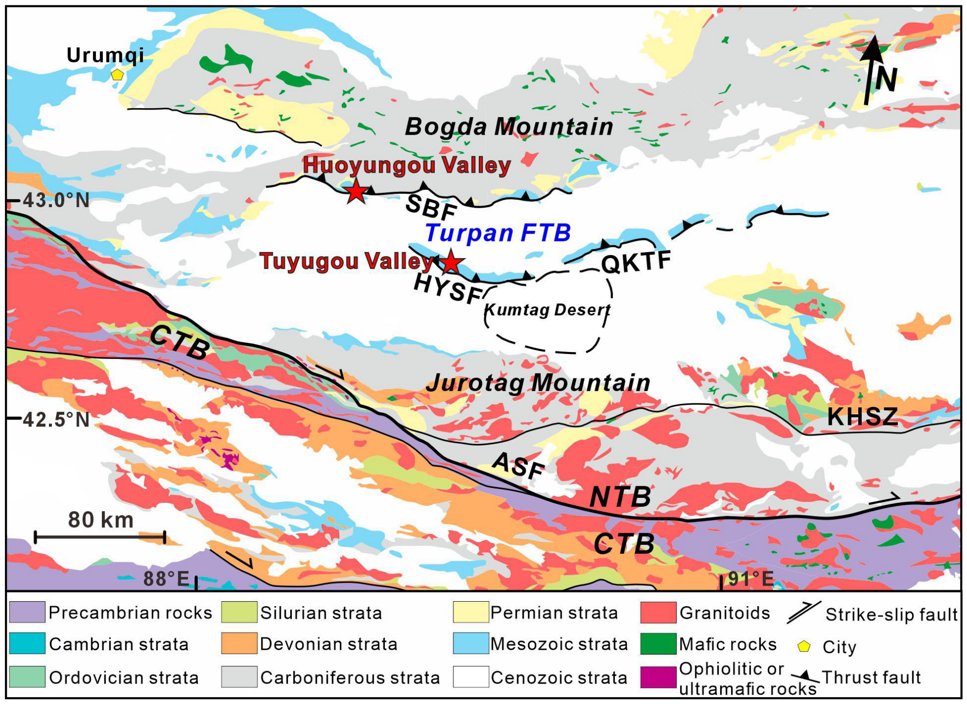
The Tianshan has experienced multiple episodes of intracontinental deformation, largely driven by the accretion of continental blocks along the southern margin of Asia during the Mesozoic and Cenozoic [36,39,40,41]. The geology of the eastern Tianshan is commonly subdivided into the Central Tianshan Block and the North Tianshan Belt, separated by the Aqikekuduke Fault (Figure 2). The Bogda Mountains are situated between the Turpan–Hami Basin and the Junggar Basin and are composed predominantly of Carboniferous–Permian strata, including marine volcanic ignimbrites, tuffaceous sandstones, volcanic flows, shallow-marine limestones, sandstones, and mudstones [42]. No pre-Carboniferous rocks are exposed [42]. The Carboniferous–Permian strata are overlain by Mesozoic–Cenozoic sedimentary units along both the southern and northern flanks of the range [43]. To the south, the Turpan Basin is an intermontane basin located between the Bogda Mountains and the Jurotag Mountains [36]. The basement of the Turpan Basin consists of Ordovician–Carboniferous oceanic crustal fragments and sedimentary rocks, overlain by a sedimentary succession dominated by Permian–Quaternary strata [44]. Mesozoic–Cenozoic strata in the Turpan Basin mainly crop out along the central structural belt, including the Huoyanshan, Qiketai, and Hongshankou structures [45].
Figure 2.
Geological map of the eastern Tianshan (modified from Li et al. [25] and Zhang et al. [45]). NTB—North Tianshan Belt; CTB—Central Tianshan Block; KHSZ—Kangguer–Huangshan Shear Zone; ASF—Aqikekuduke–Shaiquanzi Fault; SBF—South Bogda Fault; HYSF—Huoyanshan Fault; QKTF—Qiketai Fault. Red stars indicate the location of the study area.
Three fold–thrust belts (FTBs) developed sequentially between the Bogda Mountains and the Turpan Basin and were controlled by branch faults of the South Bogda Fault [36]. Syntectonic calcite U-Pb ages and low-temperature thermochronological data indicate that thrusting along the South Bogda Fault initiated at ~30 Ma, driving the initial uplift of the Bogda Mountains [36]. Thermochronological constraints and growth-strata observations further suggest that Belt I began deforming during the Early Miocene (~20 Ma), whereas Belt II and the Huoyanshan anticline underwent quasi-synchronous deformation during the Late Miocene (~10 Ma) [36]. The Huoyanshan structure records a late Quaternary shortening rate of ~2.0–3.2 mm yr−1 [37].
3. Methods
3.1. Geomorphic and UAV Surveys
Field surveys were conducted in the Tuyugou and Huoyungou valleys within the Turpan fold–thrust belt (FTB) in June 2021, 2022, and 2025 (Figure 1c and Figure 2). Terraces in the Huoyungou Valley were identified and mapped based on field observations and UAV-derived high-resolution topographic data, including a digital elevation model (DEM) and a three-dimensional model. A DJI Phantom 4 RTK (Shenzhen, China) was used for the UAV survey. The UAV has a takeoff weight of 1391 g, an operating temperature range of 0–40 °C, and a maximum flight duration of approximately 30 min. The mean flight altitude was 182.3 m, with forward and side image overlaps of 80%, and the camera was oriented at 60° to the ground surface. The survey covered an area of approximately 1.0 km2 and acquired a total of 977 images with an average ground resolution of 0.0629 m. Network Real-Time Kinematic (RTK) positioning was used for georeferencing, with horizontal and vertical standard deviations of 29.766 cm and 29.227 cm, respectively. The acquired images were processed using DJI Terra (V5.2.0) to generate orthomosaics, digital elevation models (DEMs), digital surface models (DSMs), and three-dimensional models. Slope, surface roughness, and topographic relief maps were further derived from the high-resolution DEMs. Terrace classification in the Tuyugou Valley was based on our field observations and the classification proposed by Yang et al. [37].
3.2. Optically Stimulated Luminescence Dating
A total of 11 samples were collected from the Tuyugou and Huoyungou valleys for optically stimulated luminescence (OSL) dating (Figure 1c) in this study, including four samples from Huoyungou Valley (HYG01–HYG04) and seven from Tuyugou Valley (HYS01–HYS03, HYS05, and HYS08–HYS11). OSL samples were collected by hammering opaque steel tubes into freshly cleaned sediment sections under light-shielded conditions. Quartz OSL signals provide the time elapsed since the last exposure of Quaternary sediments to sunlight and have been widely used for dating eolian and fluvial deposits [46,47,48,49,50].
All laboratory procedures were carried out under subdued red light (central wavelength 640 ± 10 nm) at Beijing OSL Laboratory Technology, Co., Ltd. (Beijing, China). Organic matter and carbonates were removed using 30% H2O2 and 30% HCl, respectively. For silty samples, the 4–11 μm fine-grained fraction was separated according to Stokes’ law and treated with H2SiF6 for 3–5 days to dissolve feldspar and other minerals, thereby purifying the quartz fraction. The purified quartz was mounted on 9.7 mm diameter stainless-steel discs using alcohol. For coarse sand samples, sediments were dried in a low-temperature oven at 40 °C and sieved to isolate the 90–150 μm grain-size fraction. The separated grains were then etched with 40% HF for 45 min to remove feldspar and the alpha-irradiated outer layer of quartz grains. The reaction was terminated by treatment with HCl, followed by rinsing, drying, and magnetic separation. The purified quartz grains were then mounted on 9.7 mm stainless-steel discs using silicone oil spray. The purity of all quartz samples was verified using an infrared (IR) light source.
Equivalent doses (De) were determined for both the fine-grained (4–11 μm) and coarse-grained (90–150 μm) quartz fractions using the simple multiple-aliquot regenerative-dose (SMAR) protocol on a Risø TL/OSL DA-20 automated luminescence reader. The blue-light stimulation source had a wavelength of 470 ± 5 nm, whereas the infrared (IR) stimulation source had a wavelength of 880 ± 60 nm, with a stimulation power of 80 mW/cm2. Optical stimulation was performed at 230 °C for 60 s following preheating at 230 °C for 10 s. Quartz OSL signals were detected using a QA9235 photomultiplier tube fitted with two 7.5 mm Hoya U-340 filters. The 90Sr/90Y beta source mounted on the system provided dose rates of 0.050 Gy/s and 0.055 Gy/s for the 4–11 μm and 90–150 μm grain-size fractions, respectively. For each sample, 18–20 aliquots were measured. The equivalent dose (De) distributions were assessed, and the central age model (CAM) was applied to samples with overdispersion values of <20% to determine the equivalent doses used for age calculation.
The concentrations of U and Th were determined by inductively coupled plasma mass spectrometry (ICP-MS), whereas K concentrations were measured using inductively coupled plasma optical emission spectrometry (ICP-OES). Environmental dose rates were calculated by combining elemental concentrations, water contents, and cosmic-ray dose rates, with the latter estimated using the model of Prescott and Hutton [51] based on sample altitude, burial depth, latitude, and longitude. All the above parameters were integrated using the DRAC software (version 1.1) to calculate the total environmental dose rate for each sample [51].
4. Results
4.1. Huoyungou Valley Terraces
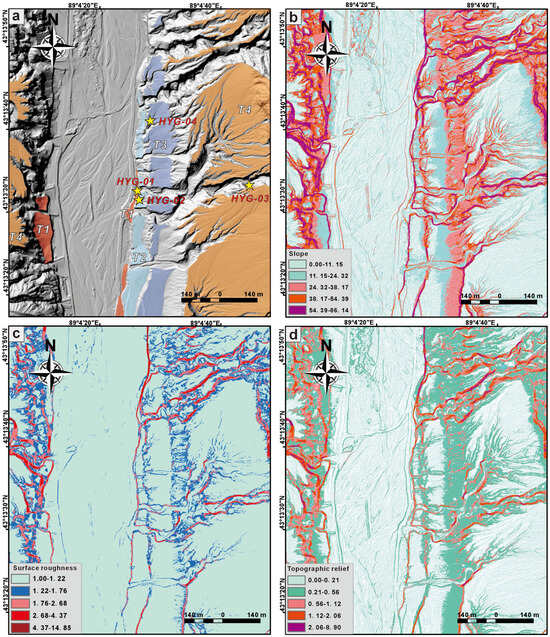
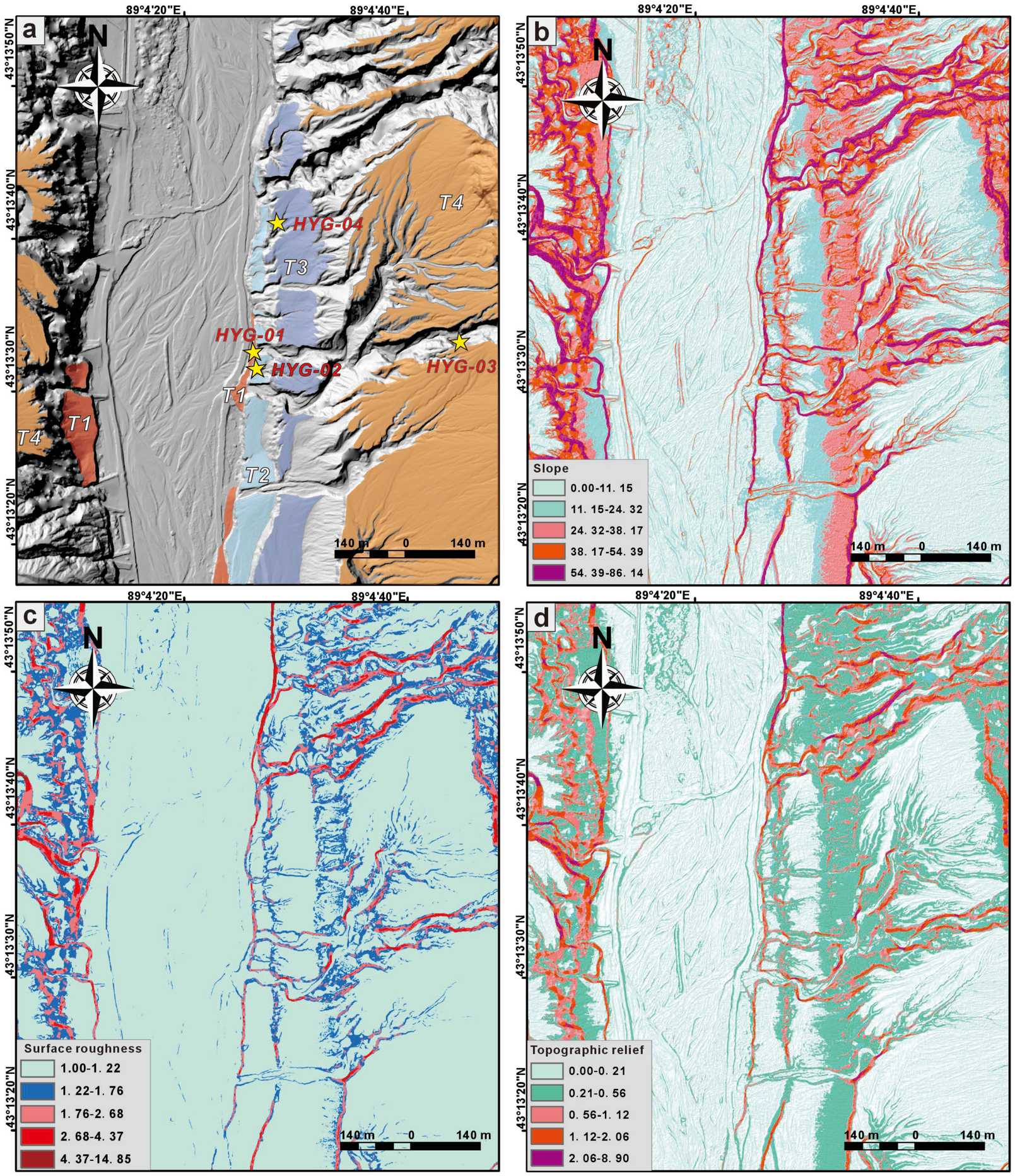
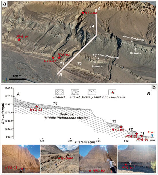
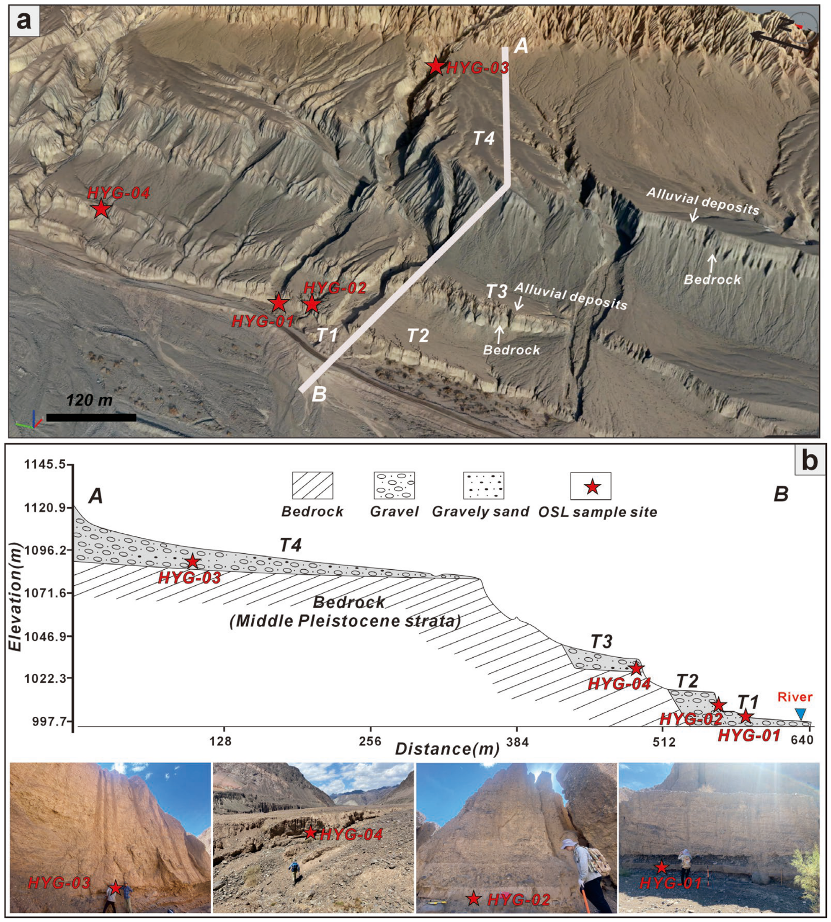
The Huoyungou Valley is located along the southern front of the Bogda Mountains (Figure 1b) and is incised by the north–south-trending Taerlang River (Figure 3a,b). A well-developed sequence of fluvial terraces is preserved along the eastern side of the river (Figure 3a,b). Four fluvial terraces (T1–T4) were identified based on UAV-derived digital elevation models (DEMs), three-dimensional (3D) models, and field investigations (Figure 3a). Terrace surfaces are characterized by gentle slopes, low surface roughness, and low topographic relief, whereas terrace scarps are characterized by steep slopes, high surface roughness, and high topographic relief (Figure 3b–d). The terraces form a well-developed staircase sequence, with increasing elevations above the modern riverbed from T1 to T4 (Figure 3c and Figure 4a). Terraces T3 and T4 are strath terraces incised into the Middle Pleistocene strata and capped by alluvial gravel deposits (Figure 4a,b). Terrace T4 is the most extensive and best-preserved terrace in the study area (Figure 3b–d and Figure 4a). The thickness of the terrace deposits decreases from more than 30 m in the east to approximately 2 m in the west (Figure 4b). Terrace T3 is capped by several meters of alluvial deposits composed predominantly of gravels with interbedded sandy lenses. Terraces T2 and T1 are fill terraces comprising several meters of fluvial deposits dominated by gravel beds interbedded with thin sand layers, with no underlying strata exposed (Figure 4b). Sample HYG-03, collected from terrace T4 (Figure 4a,b), yielded a burial age of 122.77 ± 7.18 ka. However, its equivalent dose (335.77 ± 9.02 Gy) exceeds the saturation level of the quartz OSL signal (~250 Gy) [52], indicating that the depositional age of T4 is older than ~122 ka. Samples HYG-04 and HYG-02, collected from terraces T3 and T2 (Figure 4b), yielded depositional ages of 35.94 ± 4.43 ka and 27.19 ± 2.51 ka, respectively. Sample HYG-01 from terrace T1 yielded a depositional age of 11.22 ± 3.36 ka.
Figure 3.
Terrace classification on the hillshade map of the Huoyungou Valley (a). Slope map (b), surface roughness map (c), and topographic relief map (d) derived from the high-resolution DEMs. Yellow stars indicate the locations of the OSL samples.
Figure 4.
Three-dimensional (3D) model (a) and synthetic cross section (b) showing the geomorphic framework and sampling sites of Huoyungou Valley. A and B in (a,b) represent the starting point and ending point of the cross section, respectively.
4.2. Tuyugou Valley Terraces
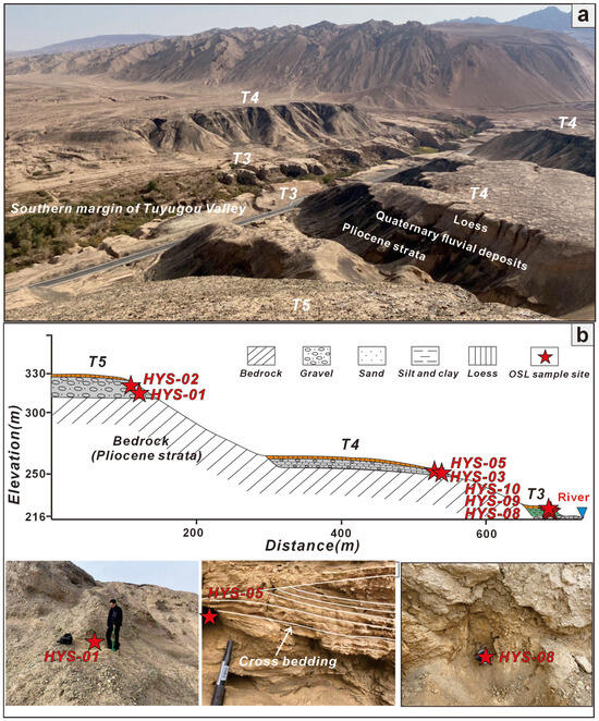
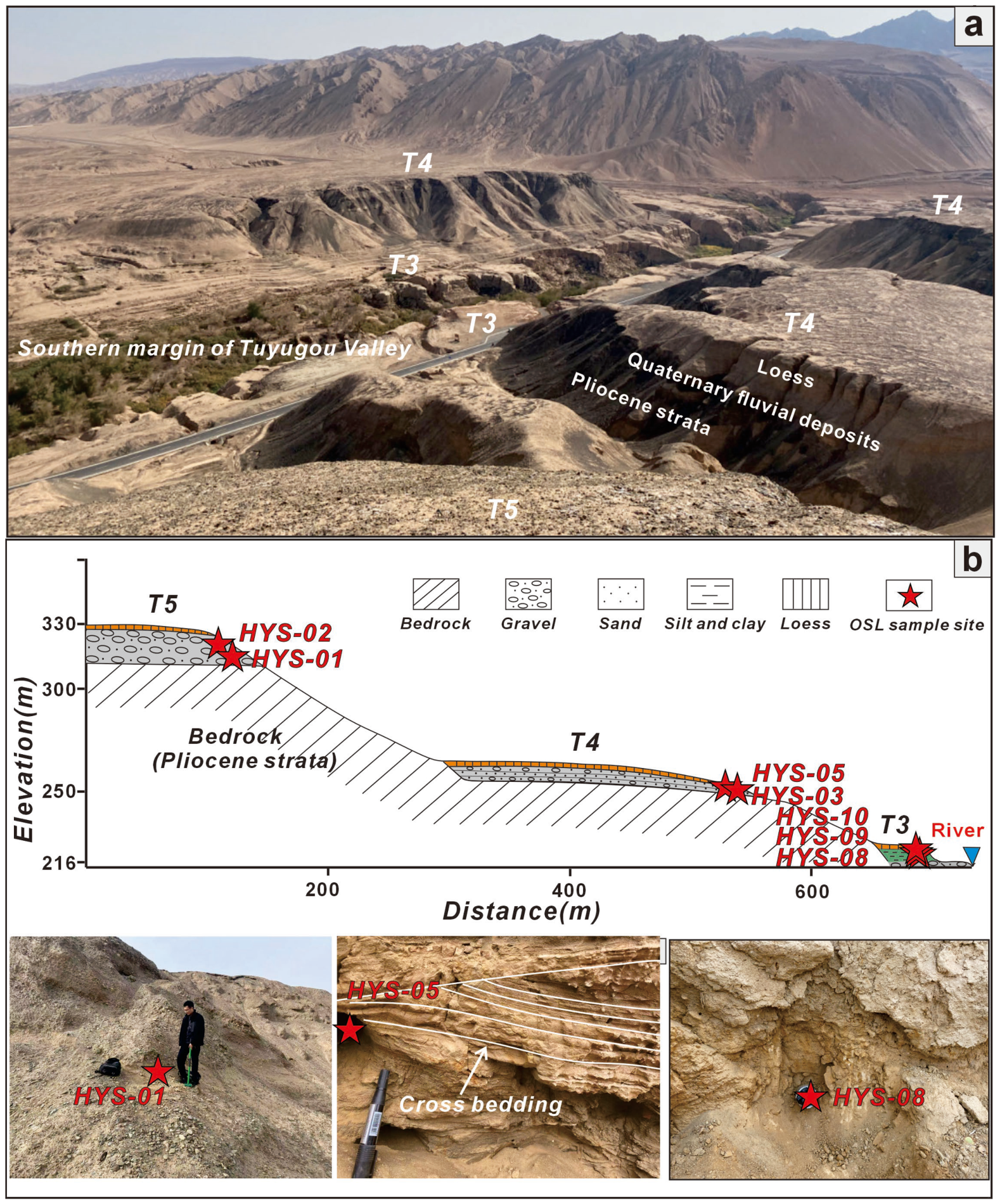
The north–south-trending Tuyugou Valley incises the Huoyanshan structure in the central Turpan Basin (Figure 1c and Figure 2). The study site is located along the northern margin of the valley. Five fluvial terraces (T1–T5) were identified based on our field survey (Figure 5a,b) and previous research [37]. Terrace T5 is a strath terrace incised into Pliocene strata and capped by tens of meters of fluvial gravel but is less continuous than the lower terraces (Figure 5a,b). In contrast, terraces T4 and T3 are laterally extensive and well preserved along the valley [37]. Terrace T4 is also incised into Pliocene strata and capped by several meters of fluvial gravel and sand (Figure 5b). Terrace T3 is a lacustrine terrace composed of tens of meters of horizontally bedded lacustrine deposits consisting predominantly of fine sand, silt, and clay (Figure 5b). All these terraces are buried beneath eolian loess of varying thicknesses (Figure 5a,b). Samples HYS-1 and HYS-2, collected from terrace T5, yielded burial ages of 124.18 ± 7.81 ka and 125.11 ± 7.03 ka, respectively. However, the equivalent doses of both samples exceed the saturation level of the quartz OSL signal [52], indicating that the depositional age of T5 is older than ~125 ka. Samples HYS-3 and HYS-5, collected from terrace T4, yielded burial ages of 48.08 ± 2.28 ka and 49.79 ± 2.43 ka, respectively. Three samples collected from the lacustrine deposits beneath terrace T3 indicate deposition between 32.21 ± 1.87 ka and 17.71 ± 0.88 ka. The OSL dating results are summarized in Table 1.
Figure 5.
Field photograph (a) and synthetic cross section (b) showing the geomorphic framework and sampling sites of Tuyugou Valley.
Table 1.
Optically stimulated luminescence (OSL) dating results of samples from the terraces in the Turpan Basin.
5. Discussion
5.1. Geomorphic and Chronologic Framework of Terraces in the Turpan Fold-and-Thrust Belt
Previous studies have shown that fluvial terraces are widely developed in the Turpan Basin [37,53,54,55]. Fluvial terraces are stair-like geomorphic features formed along rivers and are characterized by relatively flat platforms separated by steep scarps [56]. Recent advances in remote sensing techniques, particularly airborne LiDAR and photogrammetry, have enabled the generation of high-resolution digital elevation models (DEMs) and the quantitative characterization of terrace morphology [56]. Previous studies have used DEM-derived topographic metrics, such as slope and surface roughness, to distinguish relatively flat terrace surfaces from steep terrace scarps [56,57,58,59]. In the Huoyungou Valley, four terrace levels were classified based on field observations and the UAV-derived DEM and 3D model (Figure 3a and Figure 4a). Terrace scarps are characterized by steep slopes, high surface roughness, and high topographic relief, whereas terrace surfaces exhibit gentle slopes, low surface roughness, and low topographic relief (Figure 3b–d). The spatial patterns of these topographic metrics closely correspond to the terrace distribution identified from the DEM and 3D photogrammetric model, demonstrating their effectiveness in distinguishing relatively flat terrace surfaces from steep terrace scarps (Figure 3a–d). T4 and T3 are strath terraces incised into bedrock, whereas T1 and T2 are fill terraces without exposed bedrock. In the northern margin of the Tuyugou Valley in the central Turpan FTB, five terrace levels were identified. The geomorphic and sedimentary characteristics of the terraces along the entire Tuyugou Valley, as well as the late Quaternary kinematics and deformation rates of the Huoyanshan structure, have been well constrained by Yang et al. [37,55]. In the northern margin of the Tuyugou Valley, T5 and T4 are strath terraces, whereas T3 is a lacustrine terrace [37]. Throughout the Tuyugou Valley, the terrace surfaces are covered by eolian loess of varying thickness (Figure 5a) [37].
Quartz OSL signals typically saturate at doses of ~250 Gy, limiting their application to deposits younger than ~100 ka [52,60,61,62]. In contrast, feldspar luminescence signals remain unsaturated at much higher doses (~2000 Gy), substantially extending the datable age range [62,63]. Three samples collected from the highest terraces in the Tuyugou and Huoyungou valleys yielded equivalent doses exceeding 300 Gy, indicating depositional ages older than ~122–125 ka. Consequently, the ages of these terraces remain unconstrained by quartz OSL. Feldspar infrared stimulated luminescence (IRSL) dating is required to establish a more robust chronology and may enable direct dating of middle Pleistocene terrace formation. OSL ages from terrace T4 in the Tuyugou Valley (48.08 ± 2.28 and 49.79 ± 2.43 ka) indicate deposition during MIS 3, consistent with the OSL age of 51.7 ± 5.1 ka reported from the nearby Shengjingou Valley [55], suggesting regional terrace aggradation during MIS 3c (Figure 6a,b). Tuyugou Valley is relatively narrow, which may have favored river blockage and dammed-lake formation, suggesting that the lacustrine deposits of T3 may represent dammed-lake deposits [37]. Dammed lakes are commonly formed by landslides triggered by earthquakes or rainfall [64], which together account for nearly 90% of documented cases [65]. The T3 lacustrine deposits along the northern margin yielded ages of 32.21 ± 1.87 to 17.71 ± 0.88 ka. Thicker deposits farther south indicate that lake formation predates our dated sequence, but its onset and associated climatic conditions remain unconstrained. T4 records 122.2–127.2 m of vertical uplift relative to the undeformed terrace surface [37], indicating substantial Late Quaternary deformation that may have favored landsliding and river blockage. Lacustrine sedimentation ended at ca. 18 ka, broadly coincident with increased aridity during the Last Glacial Maximum (LGM). Sedimentary records from Aydingkol Lake in the Turpan Basin indicate lake-level lowering and increasing salinity under increasingly arid conditions since ca. 25 ka [66]. Pollen analyses of 13 samples from the upper part of the dammed-lake deposits indicate a cold, dry climate during the Late Pleistocene, with a progressive shift toward more arid conditions through time [67]. The overlying loess on T3 is consistent with this trend, indicating increasingly cold and arid conditions following lacustrine deposition [67]. In the Huoyungou Valley, except for the highest terrace (T4), the new OSL chronology reveals two episodes of terrace deposition at 35–27 ka (T3 and T2) and ca. 11 ka (T1).
Figure 6.
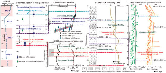
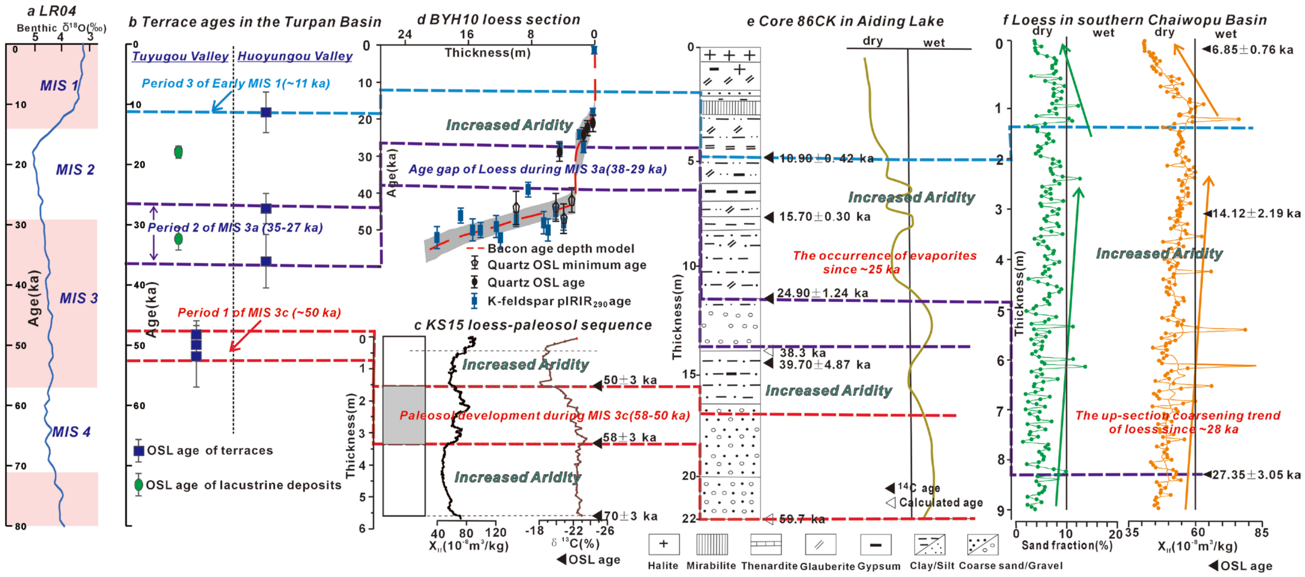
Correlation between the depositional time of terraces in the Turpan Basin and regional paleoclimate records. (a) The LR04 benthic δ18O record and marine oxygen isotope stages (modified from Lisiecki and Raymo [68]). (b) OSL ages of the terraces in the Turpan Basin (data are from Yang et al. [55] and this study). (c) Loess-paleosol sequence, χlf, and δ13Corg proxy indices from KS15 in the Yili Basin, Tianshan Mountains (modified from Li et al. [69]). (d) Quartz OSL ages and K-feldspar pIRIR ages at different depths in the loess section (BYH10) on the northern slope of the Tianshan Mountains (modified from Li et al. [70]). (e) Sedimentary characteristics and climatic changes recorded by the 86CK core from Ayding Lake (modified from Li et al. [66]). (f) Sand fraction and χlf from the loess section (URS) in the southern Chaiwopo Basin (modified from Lu et al. [71]).
Overall, the geochronological data establish a chronological framework for fluvial terrace development in the Turpan fold–thrust belt. Fluvial terrace deposition occurred mainly during MIS 3c (marine oxygen isotope stage; Lisiecki and Raymo [68]) (ca. 50 ka), MIS 3a (ca. 35–27 ka), and early MIS 1 (ca. 11 ka) (Figure 6a,b), whereas the age of the highest terrace exceeds the effective dating range of quartz OSL. This chronology is consistent with the staircase morphology of the terrace sequence, with terrace age generally increasing with elevation [48,49,72].
5.2. Climatic and Tectonic Controls on Fluvial Terrace Development in the Turpan FTB
Our OSL ages constrain the timing of terrace deposition and thus directly record episodes of aggradation. Comparison with regional paleoclimate records allows us to assess the relationship between Late Quaternary aggradation-incision processes of the Turpan FTB and climate change. Three main episodes of terrace aggradation during MIS 3c (ca. 50 ka), MIS 3a (ca. 35–27 ka), and early MIS 1 (ca. 11 ka) have been identified in this study (Figure 6a,b). We first synthesized the regional paleoclimate records of the Turpan Basin and its surrounding areas since MIS 3 (Figure 6c,f). Paleosols generally reflect pedogenesis under relatively humid conditions, whereas loess horizons indicate dry and windy conditions [69,73]. K-feldspar pIRIR ages from the KS15 loess–paleosol sequence in the Yili Basin, Tianshan Mountains, constrain paleosol formation to 58–50 ka (Figure 6c), indicating relatively moist conditions during this interval [69]. High χlf and δ13Corg values in the paleosol units relative to the loess units further indicate enhanced effective moisture during paleosol formation [69]. A shift toward arid conditions with reduced effective moisture occurred at 50–46 ka, as indicated by loess deposition [69]. Pollen records and AMS 14C dating of a 4.49 m long core from Lake Ailike, Xinjiang, indicate arid conditions during middle MIS 3 (40–33.2 ka) and semiarid conditions during late MIS 3 (33.2–26.7 ka) [74]. The BYH10 loess sequence on the northern slope of the Tianshan Mountains records a depositional hiatus during MIS 3a (38–29 ka), possibly reflecting increased precipitation that promoted vegetation cover, thereby reducing dust production in the source areas, and enhanced fluvial erosion of previously deposited loess [70]. The pollen and loess records indicate relatively humid conditions during MIS 3a [70,74]. Numerous lines of evidence indicate that the climate during MIS 2 was dry. The pollen data from Lake Ailike show extremely dry conditions during MIS 2 (26.7–12 ka) [74]. Sedimentary records from Aydingkol Lake in the Turpan Basin indicate lake-level lowering and increasing salinity under increasingly arid conditions since ca. 25 ka [66]. Grain-size variations in the URS loess section of the southern Chaiwopu Basin show an upward-coarsening trend since ca. 28 ka, indicating strengthened winds and increasing aridity during MIS 2 [71]. Aridity weakened near the MIS 2–MIS 1 transition, as indicated by decreasing grain size and sand content [71]. During early MIS 1, finer sediment grains and magnetic particles, as well as lower χlf values, record a transition from cold and dry to relatively warm conditions [71]. The Holocene pollen accumulation rate at Lake Ailike is approximately three orders of magnitude higher than during MIS 3c, consistent with pollen records from Lakes Balikun and Ebi [74]. These records indicate substantially wetter conditions during the Holocene than during middle to late MIS 3 across arid Central Asia [74].
Regional paleoclimate records indicate relatively humid conditions during MIS 3c, MIS 3a, and early MIS 1 in Turpan Basin and surrounding regions, broadly corresponding to the three main episodes of terrace aggradation in the Turpan Basin (Figure 6a–f). The hydrological changes induced by late Quaternary climate transitions have been proposed to contribute to terrace aggradation and incision in the Tianshan and Altay regions [2,8,11,75,76]. Climate variability alters the sediment flux-to-water discharge ratio (Qs/Qw) [8,11]. Cold and dry conditions enhance sediment production through glacial and periglacial processes, resulting in temporary storage of large volumes of detritus in upstream catchments [2,8,11,75]. Some of these sediments were transported by meltwater and deposited in the piedmont, forming extensive alluvial fans [76]; for example, terrace alluvium along the mountain front of the Chinese Altay Shan accumulated during glacial stages [2]. However, little water discharge may be available to transport and evacuate glacial and periglacial sediments over long distances during these periods [8]. Aggradation tends to occur during stadial–interstadial transitions and is driven by an increased flux of glacial sediment accumulated in the high range and flushed onto the piedmont by greater water discharge [8,75]. The OSL results and regional paleoclimatic records suggest that terrace aggradation in the Turpan fold–thrust belt occurred during episodic humid intervals (Figure 6a–f). As sediment supply from the catchment decreased in response to strengthened transportation during wet conditions, river incision then became dominant due to enhanced river transport capacity caused by the decreased Qs/Qw ratio [2,8,11,75,76]. Therefore, the correlation between terrace chronology and climate records supports the interpretation that fluvial processes were driven by climate-induced changes in the Qs/Qw ratio (Figure 6a–f).
Tectonic uplift plays an important role in terrace incision and preservation, as widely documented in Central Asia and other regions worldwide [4,6,23,77]. The Turpan fold–thrust belt has experienced persistent deformation since the Late Miocene and remains tectonically active today [36,37,55]. Rock uplift provides a background forcing for long-term fluvial incision [6,13] and can significantly accelerate river downcutting [4,7,23]. Previous studies suggest that tectonic uplift has contributed to fluvial incision in the Tuyugou Valley in the central Turpan FTB [37]. By subtracting the undeformed terrace height from the maximum terrace height to remove the component associated with river incision, which may result from climate and base-level changes, Yang et al. [37] quantified vertical uplift attributable to fold growth as 14.8–16.6 m for T1, 36.7–40.5 m for T2, and 122.2–127.2 m for T4. It seems that climate forcing may drive the initial incision and abandonment of fluvial terraces, whereas the magnitude of fluvial incision is also strongly influenced by tectonic uplift in the Turpan FTB. Similar relationships between climate-driven terrace formation and tectonically enhanced incision have been reported in other tectonically active regions. In the Hongshuiba River on the northern margin of the Qilian Shan, climate forcing may have driven the initial abandonment of fluvial terraces, whereas the magnitude of fluvial incision was mainly controlled by progressive tectonic uplift [7]. Along the southern piedmont of the Tian Shan, climate change controlled terrace formation, whereas tectonically induced river incision may account for approximately 60–70% of the total incision in the uplifted frontal thrust system [4]. The activities of the Haiyuan Fault, along with the integral uplift of northeastern Tibet, play an important role in accelerating the incision rate in the Mijia Shan [78]. Tectonic uplift may also play an important role in the long-term preservation of river terraces [6]. Not all terraces can be preserved over long timescales, particularly where the height difference between the terrace surface and the active river channel remains small [6]. After terrace abandonment, sustained uplift progressively elevates the terrace above the active floodplain, reducing its susceptibility to fluvial erosion and lateral planation and thereby favoring long-term terrace preservation [4,6,7,77]. Based on 22 terrace sequences from the NE Tibetan Plateau, Ma et al. [6] found that terrace preservation rates are linearly correlated with rock uplift rates. Numerical modeling further suggests that tectonic uplift exerts an important control on long-term terrace preservation [79].
Taken together, we suggest that climate-induced changes in hydrological conditions, particularly the Qs/Qw ratio, control the timing of terrace aggradation and incision, whereas tectonic uplift may influence the magnitude of river incision and promote the long-term preservation of terraces in the Turpan FTB. Climate-driven fluvial terrace development since the Late Quaternary appears to be a common phenomenon across the arid interior of Asia, including the Tianshan, Altay Mountains, and northeastern Tibetan Plateau [2,4,6,7].
6. Conclusions
Based on field surveys, UAV-derived high-resolution topography, and OSL dating of fluvial terraces in the Turpan fold–thrust belt, eastern Tianshan, we reconstruct the geomorphic and chronological framework of late Quaternary terrace development in the region. Four terrace levels are preserved in the Huoyungou Valley, and five terrace levels are classified along the northern margin of the Tuyugou Valley. Terrace aggradation occurred mainly during MIS 3c (ca. 50 ka), MIS 3a (ca. 35–27 ka), and early MIS 1 (ca. 11 ka), whereas the highest terraces exceed the effective dating range of quartz OSL. Comparison of the terrace chronology with regional paleoclimate records suggests that climate-induced changes in hydrological conditions, particularly the Qs/Qw ratio, controlled the timing of terrace aggradation and abandonment. Previous studies suggest that persistent tectonic uplift influenced the magnitude of river incision and promoted long-term terrace preservation. Given the persistent tectonic deformation and climatic fluctuations in the Turpan FTB during the late Quaternary, we suggest that climate-induced changes in hydrological conditions controlled the timing of terrace aggradation and subsequent abandonment, whereas tectonic uplift influenced the magnitude of river incision and promoted the long-term preservation of terraces.
Author Contributions
Conceptualization, D.Z. and G.W.; methodology, D.Z. and G.W.; software, D.Z.; investigation, D.Z., G.W. and T.S.; writing—original draft preparation, D.Z., G.W. and T.S.; writing—review and editing, D.Z., G.W. and T.S.; funding acquisition, D.Z. and G.W. All authors have read and agreed to the published version of the manuscript.
Funding
This research was funded by the National Natural Science Foundation of China (grants 42430307 and 42172251) and Chengdu University of Technology Everest Talent Research Startup Fund (10912-KYQD2025-10942).
Data Availability Statement
The original contributions presented in the study are included in the article, further inquiries can be directed to the corresponding author.
Conflicts of Interest
The authors declare no conflicts of interest.
References
- Ruscitto, V.; Delchiaro, M.; Richard, M.; Iacobucci, G.; Piacentini, D.; Troiani, F.; Della Seta, M. Quaternary landscape evolution of Apennines peri-Adriatic belt: Insights into climate and tectonics from the fluvial record. Sci. Adv. 2026, 12, eaec5376. [Google Scholar] [CrossRef] [Scilit] [PubMed]
- Mao, Z.; Wu, M.; Lu, H.; Pang, L.; Zhao, J.; Jiang, Y.; Lü, Y.; Zheng, X.; Li, Y. Climatically-driven development of late Quaternary fluvial geomorphology in the arid inland of Asia. Geomorphology 2024, 464, 109380. [Google Scholar] [CrossRef] [Scilit]
- Zhao, X.; Zhang, H.; Lv, H.; Lü, Y.; Li, X.; Liu, K.; Zhang, J.; Xiong, J. Signatures of tectonic-climatic interaction during the Late Cenozoic orogenesis along the northern Chinese Tian Shan. Basin Res. 2021, 33, 291–311. [Google Scholar] [CrossRef] [Scilit]
- Huang, W.-L.; Yang, X.-P.; Li, A.; Thompson, J.A.; Zhang, L. Climatically controlled formation of river terraces in a tectonically active region along the southern piedmont of the Tian Shan, NW China. Geomorphology 2014, 220, 15–29. [Google Scholar] [CrossRef] [Scilit]
- Whipple, K.X. The influence of climate on the tectonic evolution of mountain belts. Nat. Geosci. 2009, 2, 97, Erratum in Nat. Geosci. 2009, 2, 730. https://doi.org/10.1038/ngeo638. [Google Scholar] [CrossRef] [Scilit]
- Ma, Z.; Peng, T.; Feng, Z.; Li, X.; Song, C.; Wang, Q.; Tian, W.; Zhao, X. Tectonic and climate controls on river terrace formation on the northeastern Tibetan Plateau: Evidence from a terrace record of the Huangshui River. Quat. Int. 2023, 656, 16–25. [Google Scholar] [CrossRef] [Scilit]
- Yang, H.; Yang, X.; Huang, W.; Li, A.; Hu, Z.; Huang, X.; Yang, H. 10Be and OSL dating of the Pleistocene fluvial terraces of the Hongshuiba River: Constraints on tectonic and climatic drivers for fluvial downcutting across the NE Tibetan Plateau margin, China. Geomorphology 2020, 348, 106884. [Google Scholar] [CrossRef] [Scilit]
- Malatesta, L.C.; Avouac, J.-P.; Brown, N.D.; Breitenbach, S.F.M.; Pan, J.; Chevalier, M.-L.; Rhodes, E.; Saint-Carlier, D.; Zhang, W.; Charreau, J.; et al. Lag and mixing during sediment transfer across the Tian Shan piedmont caused by climate-driven aggradation-incision cycles. Basin Res. 2018, 30, 613–635. [Google Scholar] [CrossRef] [Scilit]
- Yang, R.; Willett, S.D.; Goren, L. In situ low-relief landscape formation as a result of river network disruption. Nature 2015, 520, 526–529. [Google Scholar] [CrossRef] [Scilit] [PubMed]
- Yin, A.; Dang, Y.Q.; Zhang, M.; Chen, X.H.; McRivette, M.W. Cenozoic tectonic evolution of the Qaidam basin and its surrounding regions (Part 3): Structural geology, sedimentation, and regional tectonic reconstruction. Geol. Soc. Am. Bull. 2008, 120, 847–876. [Google Scholar] [CrossRef] [Scilit]
- Lu, H.; Wu, D.; Zhang, H.; Ma, Y.; Zheng, X.; Li, Y. Spatial patterns of Late Quaternary River incision along the northern Tian Shan foreland. Geomorphology 2020, 357, 10700. [Google Scholar] [CrossRef] [Scilit]
- Hetzel, R.; Niedermann, S.; Tao, M.; Kubik, P.W.; Strecker, M.R. Climatic versus tectonic control on river incision at the margin of NE Tibet: 10Be exposure dating of river terraces at the mountain front of the Qilian Shan. J. Geophys. Res. 2006, 111, F03012. [Google Scholar] [CrossRef] [Scilit]
- Pan, B.; Burbank, D.W.; Wang, Y.; Wu, G.; Li, J.; Guan, Q. A 900 k.y. record of strath terrace formation during glacial-interglacial transitions in Northwest China. Geology 2003, 31, 957–960. [Google Scholar] [CrossRef] [Scilit]
- Willett, S.D.; Hovius, N.; Brandon, M.T.; Fisher, D.M. Tectonics, Climate, and Landscape Evolution; Geological Society of America: Boulder, CO, USA, 2006; Volume 398, pp. vii–xi. [Google Scholar] [CrossRef] [Scilit]
- Pang, L.; Lu, H.; Lu, Y.; Jiang, Y.; Wu, D.; Wu, M.; Zheng, X.; Li, Y. 10Be dating of the Kuitun River terraces in the northern Chinese Tian Shan foreland: Insights into fluvial evolution and tectonic shortening pattern. Geomorphology 2022, 412, 108317. [Google Scholar] [CrossRef] [Scilit]
- Hu, X.; Wu, J.; Wen, Z.; Zhang, J.; Zhao, Q.; Pan, B. Fluvial evolution in a growing thrust-fold range of the Yumu Shan, NE Tibetan Plateau. Earth Planet. Sci. Lett. 2022, 594, 117704. [Google Scholar] [CrossRef] [Scilit]
- Gao, H.; Li, Z.; Liu, X.; Pan, B.; Wu, Y.; Liu, F. Fluvial terraces and their implications for Weihe River valley evolution in the Sanyangchuan Basin. Sci. China Earth Sci. 2017, 6, 413–427. [Google Scholar] [CrossRef] [Scilit]
- Erlanger, E.D.; Granger, D.E.; Gibbon, R.J. Rock uplift rates in South Africa from isochron burial dating of fluvial and marine terraces. Geology 2012, 40, 1019–1022. [Google Scholar] [CrossRef] [Scilit]
- Guralnik, B.; Matmon, A.; Avni, Y.; Porat, N.; Fink, D. Constraining the evolution of river terraces with integrated OSL and cosmogenic nuclide data. Quat. Geochronol. 2011, 6, 22–32. [Google Scholar] [CrossRef] [Scilit]
- Bridgland, D.; Westaway, R. Climatically controlled river terrace staircases: A worldwide Quaternary phenomenon. Geomorphology 2008, 98, 285–315. [Google Scholar] [CrossRef] [Scilit]
- Scharer, K.M.; Burbank, D.W.; Chen, J.; Weldon, R.J., II. Kinematic models of fluvial terraces over active detachment folds: Constraints on the growth mechanism of the Kashi-Atushi fold system, Chinese Tian Shan. Geol. Soc. Am. Bull. 2006, 118, 1006–1021. [Google Scholar] [CrossRef]
- Carcaillet, J.; Mugnier, J.L.; Koçi, R.; Jouanne, F. Uplift and active tectonics of southern Albania inferred from incision of alluvial terraces. Quat. Res. 2009, 71, 465–476. [Google Scholar] [CrossRef] [Scilit]
- Maddy, D.; Bridgland, D.; Westaway, R. Uplift-driven valley incision and climate-controlled river terrace development in the Thames Valley, UK. Quat. Int. 2001, 79, 23–36. [Google Scholar] [CrossRef] [Scilit]
- Molnar, P.; Brown, E.T.; Burchfiel, B.C.; Deng, Q.; Feng, X.; Li, J.; Raisbeck, G.M.; Shi, J.; Zhang, W.; Yiou, F. Quaternary climate change and the formation of river terraces across growing anticlines on the north flank of the Tien Shan, China. J. Geol. 1994, 102, 583–602. [Google Scholar] [CrossRef] [Scilit]
- Li, P.; Sun, M.; Rosenbaum, G.; Cai, K.; Yaun, C.; Jourdan, F.; Xia, X.; Jiang, Y.; Zhang, Y. Tectonic evolution of the Chinese Tianshan Orogen from sub-duction to arc-continent collision: Insight from poly-phase deformation along the Gangou section, Central Asia. Geol. Soc. Am. Bull. 2020, 132, 2529–2552. [Google Scholar] [CrossRef] [Scilit]
- Chen, Y.; Wang, G.; Kapp, P.; Shen, T.; Zhang, P.; Zhu, C.; Cao, K. Episodic exhumation and related tectonic controlling during Mesozoic in the Eastern Tian Shan, Xinjiang, northwestern China. Tectonophysics 2020, 796, 228647. [Google Scholar] [CrossRef] [Scilit]
- Wang, M.; Shen, Z. Present-day crustal deformation of continental China derived from GPS and its tectonic implications. J. Geophys. Res. Solid Earth 2020, 125, e2019JB018774. [Google Scholar] [CrossRef] [Scilit]
- Abdrakhmatov, K.Y.; Aldazhanov, S.A.; Hager, B.H.; Hamburger, M.W.; Herring, T.A.; Kalabaev, K.B.; Makarov, V.I.; Molnar, P.; Panasyuk, S.V.; Prilepin, M.T.; et al. Relatively recentconstruction of the Tien Shan inferred from GPS measurements of present-day crustal deformation rates. Nature 1996, 384, 450–453. [Google Scholar] [CrossRef] [Scilit]
- Sobel, E.R.; Chen, J.; Heermance, R.V. Late Oligocene–Early Miocene initiation of shortening in the southwestern Chinese Tian Shan: Implications for Neogene shortening rate variations. Earth Planet. Sci. Lett. 2006, 247, 70–81. [Google Scholar] [CrossRef] [Scilit]
- Dumitru, T.A.; Zhou, D.; Chang, E.Z.; Graham, S.A.; Hendrix, M.S.; Sobel, E.R.; Carroll, A.R. Uplift, exhumation, and deformation in the Chinese Tian Shan. GSA Mem. 2001, 194, 71–99. [Google Scholar] [CrossRef] [Scilit]
- Hendrix, M.S.; Dumitru, T.A.; Graham, S.A. Late Oligocene–early Miocene unroofing in the Chinese Tian Shan: An early effect of the India–Asia collision. Geology 1994, 22, 487–490. [Google Scholar] [CrossRef] [Scilit]
- Lu, H.; Zhang, W.; Li, Y.; Dong, C.; Zhang, T.; Zhou, Z.; Zheng, X. Rock magnetic properties and paleo-environmental implications of an 8-Ma late Cenozoic terrigenous succession from the northern Tian Shan foreland basin, northwestern China. Glob. Planet. Change 2013, 111, 43–56. [Google Scholar] [CrossRef] [Scilit]
- Charreau, J.; Chen, Y.; Gilder, S.; Barrier, L.; Dominguez, S.; Augier, R.; Sen, S.; Avouac, J.; Gallaud, A.; Graveleau, F.; et al. Neogene uplift of the Tian Shan Mountains observed in the magnetic record of the Jingou River section (northwest China). Tectonics 2009, 28, TC2008. [Google Scholar] [CrossRef] [Scilit]
- Heermance, R.V.; Chen, J.; Burbank, D.W.; Miao, J. Temporal constraints and pulsed Late Cenozoic deformation during the structural disruption of the active Kashi foreland, northwest China. Tectonics 2008, 27, TC6012. [Google Scholar] [CrossRef] [Scilit]
- Huang, B.; Piper, J.; Peng, S.; Liu, T.; Li, Z.; Wang, Q.; Zhu, R. Magnetostragraphic study of the Kuche Depression, Tarim Basin, and Cenozoic uplift of the Tian Shan Range, Western China. Earth Planet. Sci. Lett. 2006, 251, 346–364. [Google Scholar] [CrossRef] [Scilit]
- Jing, H.; Wang, W.; Zhang, P.; Wang, Y.; Pang, J.; Zhang, Y.; Li, Z.; Yan, Y.; Zhang, H.; Zheng, D. Multi-stage uplift and propagation of the Chinese East Tianshan during the Cenozoic. Tectonics 2025, 44, e2024TC008666. [Google Scholar] [CrossRef] [Scilit]
- Yang, X.; Wu, C.; Li, Z.; Wang, W.; Chen, G.; Duan, L. Late Quaternary Kinematics and Deformation Rate of the Huoyanshan Structure Derived From Deformed River Terraces in the South Piedmont of the Eastern Chinese Tian Shan. Front. Earth Sci. 2021, 9, 649011. [Google Scholar] [CrossRef] [Scilit]
- Du, L.; Wong, J.; Li, Z.; Chen, L.; Zhang, B.; Lei, B.; Peng, Z. Hydroclimatic Change in Turpan Basin under Climate Change. Water 2023, 15, 3422. [Google Scholar] [CrossRef] [Scilit]
- Jolivet, M.; Dominguez, S.; Charreau, J.; Chen, Y.; Li, Y.; Wang, Q. Mesozoic and Cenozoic tectonic history of the central Chinese TianShan: Reactivated tectonic structures and active deformation. Tectonics 2010, 29, TC6019. [Google Scholar] [CrossRef] [Scilit]
- Wang, Z.; Li, T.; Zhang, J.; Liu, Y.; Ma, Z. The uplifting process of the Bogda Mountain during the Cenozoic and its tectonicimplication. Sci. China Ser. D Earth Sci. 2008, 51, 579–593. [Google Scholar] [CrossRef] [Scilit]
- Hendrix, M.S.; Graham, S.A.; Carroll, A.R.; Sobel, E.R.; Mcknight, C.L.; Schulein, B.J.; Wang, Z. Sedimentary record and climaticimplications of recurrent deformation in the Tian Shan: Evidence from Mesozoic strata of the north Tarim, south Junggar, and Turpan basins, northwest China. Geol. Soc. Am. Bull. 1992, 104, 53–79. [Google Scholar] [CrossRef] [Scilit]
- Wali, G.; Wang, B.; Cluzel, D.; Zhong, L. Carboniferous-Early Permian magmatic evolution of the Bogda Range (Xinjiang, NW China): Implications for the Late Paleozoic accretionary tectonics of the SW Central Asian Orogenic Belt. J. Asian Earth Sci. 2018, 153, 238–251. [Google Scholar] [CrossRef] [Scilit]
- Allen, M.B.; Windley, B.F.; Zhang, C.; Guo, J. Evolution of the Turfan Basin, Chinese central Asia. Tectonics 1993, 12, 889–896. [Google Scholar] [CrossRef] [Scilit]
- Zhen, Y.; He, D.; Li, D.; Chen, X.; Fu, G. Episodic evolution of intracontinental orogenic deformation: Insight from the southern Bogda fold-and-thrust belt of the Tianshan Mountains, NW China. Tectonophysics 2024, 876, 230266. [Google Scholar] [CrossRef] [Scilit]
- Zhang, D.; Wang, G.; Cheng, F.; Shen, T.; Ji, J. Late Cenozoic sedimentary records of the uplift of the Karlik Mountain and aridifation of the Hami Basin. J. Geol. Soc. 2025, 182, jgs2024-213, Correction in J. Geol. Soc. 2025, 182, jgs2025-124. https://doi.org/10.1144/jgs2025-124. [Google Scholar] [CrossRef] [Scilit]
- Wintle, A.G. Luminescence dating: Where it has been and where it is going. Boreas 2008, 37, 471–482. [Google Scholar] [CrossRef] [Scilit]
- Murray, A.; Arnold, L.J.; Buylaert, J.-P.; Guérin, G.; Qin, J.; Singhvi, A.K.; Smedley, R.; Thomsen, K.J. Optically stimulated luminescence dating using quartz. Nat. Rev. Methods Primers 2021, 1, 72. [Google Scholar] [CrossRef] [Scilit]
- Zhang, D.; Wang, G.; Pullen, A.; Abell, J.T.; Ji, J.; Shen, T. Landscape evolution and development of eolian-modified unconsolidated gravel surfaces and yardangs in the Hami Basin, China. Geomorphology 2020, 368, 107355. [Google Scholar] [CrossRef] [Scilit]
- Cordier, S.; Harmand, D.; Lauer, T.; Voinchet, P.; Bahain, J.J.; Frechen, M. Geochronological reconstruction of the Pleistocene evolution of the Sarre valley (France and Germany) using OSL and ESR dating techniques. Geomorphology 2012, 165, 91–106. [Google Scholar] [CrossRef] [Scilit]
- Prescott, J.R.; Hutton, J.T. Cosmic ray contributions to dose rates for luminescence and ESR dating: Large depths and long-term time variations. Radiat. Meas. 1994, 23, 497–500. [Google Scholar] [CrossRef] [Scilit]
- Durcan, J.A.; King, G.E.; Duller, G.A.T. DRAC: Dose Rate and Age Calculator for trapped charge dating. Quat. Geochronol. 2015, 28, 54–61. [Google Scholar] [CrossRef] [Scilit]
- Chawla, S.; Gundu Rao, T.K.; Singhvi, A.K. Quartz thermoluminescence: Dose and dose-rate effects and their implications. Radiat. Meas. 1998, 29, 53–63. [Google Scholar] [CrossRef] [Scilit]
- Deng, Q.; Feng, X.; Zhang, P.; Xu, X.; Yang, X.; Peng, S.; Li, J. Active Teconics in Tianshan; Seismological Press: Beijing, China, 2000; (In Chinese with English abstract). [Google Scholar]
- Cheng, J.; Zhang, Q.; Zhang, X.; Pan, W.; Zhang, X.; Yu, W. Environmental Evolution During the Cenozoic in the Turpan Basin; Seismological Press: Beijing, China, 2005; pp. 33–38. [Google Scholar]
- Yang, X.; Li, Z.; Wang, W.; Zhang, P.; Wu, C.; Chen, G.; Duan, L.; Wu, X.; Liu, K. Quaternary Crustal Shortening of the Houyanshan Structure in the Eastern Chinese Tian Shan: Constrained from Geological and Geomorphological Analyses. Remote Sens. 2023, 15, 1603. [Google Scholar] [CrossRef] [Scilit]
- Komori, J.; Meltzner, A.J. Automatic detection and classification of marine and fluvial terraces using statistical and stochastic clustering methods. Geomorphology 2025, 488, 109956. [Google Scholar] [CrossRef] [Scilit]
- Rodríguez-Rodríguez, L.; Ant’on, L.; Pall’as, R.; García-Castellanos, D.; Jim’enez-Munt, I.; Pastor-Martín, C. A GIS method to identify flat surfaces and restore relict fluvial long-profiles from terrace remnants gives new clues on how large basins respond to endorheic–exorheic transitions (Duero basin, Iberian Peninsula). Earth Surf. Process. Landf. 2020, 45, 1013–1027. [Google Scholar] [CrossRef] [Scilit]
- Jara-Muñoz, J.; Melnick, D.; Strecker, M.R. TerraceM: A MATLAB® tool to analyze marine and lacustrine terraces using high-resolution topography. Geosphere 2016, 12, 176–195. [Google Scholar] [CrossRef] [Scilit]
- Jara-Muñoz, J.; Melnick, D.; Pedoja, K.; Strecker, M.R. TerraceM-2: A Matlab® interface for mapping and modeling marine and lacustrine terraces. Front. Earth Sci. 2019, 7, 255, Erratum in Front. Earth Sci. 2020, 8, 8. https://doi.org/10.3389/feart.2020.00008. [Google Scholar] [CrossRef] [Scilit]
- Wintle, A.G.; Murray, A.S. A review of quartz optically stimulated luminescence characteristics and their relevance in single-aliquot regeneration dating protocols. Radiat. Meas. 2006, 41, 369–391. [Google Scholar] [CrossRef] [Scilit]
- Singhal, M.; Panda, M.; Shinde, S.H.; Mondal, S.; Annalakshmic, O.; Chauhana, N. Study of thermoluminescence characteristics of quartz for high radiation doses (>1kGy): Implications for extending the luminescence dating range. Radiat. Meas. 2024, 178, 107300. [Google Scholar] [CrossRef] [Scilit]
- Singhal, M.; Panda, M.; Annalakshmi, O.; Chauhan, N. On the sensitivity normalization for blue stimulated luminescence of quartz. Radiat. Phys. Chem. 2025, 234, 112764. [Google Scholar] [CrossRef] [Scilit]
- Thiel, C.; Buylaert, J.P.; Murray, A.; Terhorst, B.; Hofer, I.; Tsukamoto, S.; Frechen, M. Luminescence dating of the Stratzing loess profile (Austria)—Testing the potential of an elevated temperature post-IR IRSL protocol. Quat. Int. 2011, 234, 23–31. [Google Scholar] [CrossRef] [Scilit]
- Zhong, Q.; Wang, L.; Shan, Y.; Mei, S.; Zhang, Q.; Yang, M.; Zhang, L.; Du, Z. Review on risk assessments of dammed lakes. Front. Earth Sci. 2023, 10, 981068. [Google Scholar] [CrossRef] [Scilit]
- Shen, D.; Shi, Z.; Peng, M.; Zhang, L.; Jiang, M. Longevity analysis of landslide dams. Landslides 2020, 17, 1797–1821. [Google Scholar] [CrossRef] [Scilit]
- Li, B.; Cai, B.; Liang, Q. Sedimentary features in Aydingkol Lake of Turpan Basin. Kexue Tongbao 1989, 34, 608–610. (In Chinese) [Google Scholar]
- Pan, W.; Cheng, J.; Wang, S. Quaternary climate change in Turpan basin and its significance to sandstone-type uranium mineralization. Uranium Geol. 2003, 19, 333–338, (In Chinese with English abstract). [Google Scholar]
- Lisiecki, L.E.; Raymo, M.E. A Pliocene-Pleistocene stack of 57 globally distributed benthic δ18O records. Paleoceanography 2005, 20, PA1003, Correction in Paleoceanography 2005, 20, PA2007. https://doi.org/10.1029/2005PA001164. [Google Scholar] [CrossRef] [Scilit]
- Li, G.; Chen, F.; Xia, D.; Yang, H.; Zhang, X.; Madsen, D.; Oldknow, C.; Wei, H.; Rao, Z.; Qiang, M. A Tianshan Mountains loess-paleosol sequence indicates anti-phase climatic variations in arid central Asia and in East Asia. Earth Planet. Sci. Lett. 2018, 494, 153–163. [Google Scholar] [CrossRef] [Scilit]
- Li, G.; Rao, Z.; Duan, Y.; Xia, D.; Wang, L.; Madsen, D.B.; Jia, J.; Wei, H.; Qiang, M.; Chen, J.; et al. Paleoenvironmental changes recorded in a luminescence dated loess/paleosol sequence from the Tianshan Mountains, arid central Asia, since the Penultimate Glaciation. Earth Planet. Sci. Lett. 2016, 448, 1–12. [Google Scholar] [CrossRef] [Scilit]
- Lu, H.; Xu, Y.; Niu, Y.; Wang, Z.; Wang, H.; Zhao, J.; Zhang, W.; Zheng, X. Late Quaternary loess deposition in the southern Chaiwopu Basin of the northern Chinese Tian Shan foreland and its palaeoclimatic implications. Boreas 2016, 45, 304–321. [Google Scholar] [CrossRef] [Scilit]
- Voinchet, P.; Yin, G.; Falguères, C.; Liu, C.; Han, F.; Sun, X.; Bahain, J.J. Dating of the stepped quaternary fluvial terrace system of the Yellow River by electron spin resonance (ESR). Quat. Geochronol. 2019, 49, 278–282. [Google Scholar] [CrossRef] [Scilit]
- Ding, Z.; Ranov, V.; Yang, S.; Finaev, A.; Han, J.; Wang, G. The loess record in southern Tajikistan and correlation with Chinese loess. Earth Planet. Sci. Lett. 2002, 200, 387–400. [Google Scholar] [CrossRef] [Scilit]
- Chen, Y.; Liu, X. Vegetation and climate changes since the middle MIS 3 inferred from a Lake Ailike pollen record, xinjiang, arid central asia. Quat. Sci. Rev. 2022, 290, 107636. [Google Scholar] [CrossRef] [Scilit]
- Lu, H.; Jiang, Y.; Pang, L.; Wu, D.; Zheng, X.; Li, Y. Possible uncertainties of deformation rates of active thrust-related folds constrained by fluvial terraces: A case study from the northern piedmont of the Chinese Tianshan Mountains. Acta Geol. Sin. 2022, 96, 1883–1894, (In Chinese with English abstract). [Google Scholar]
- Huang, M.; Lu, H.; Pang, L.; Mao, Z.; Jiang, Y.; Fang, Y.; Zheng, X. Geomorphic analysis of late Quaternary convergent-downstream terrace profiles in the foreland of the northern Chinese Tian Shan: Evidence that climate factors, not differential tectonic uplift, dominated fluvial evolution. Palaeogeogr. Palaeoclimatol. Palaeoecol. 2026, 689, 113643. [Google Scholar] [CrossRef] [Scilit]
- Pan, B.; Su, H.; Hu, Z.; Hu, X.; Gao, H.; Li, J.; Kirby, E. Evaluating the role of climate and tectonics during non-steady incision of the Yellow River: Evidence from a 1.24 Ma terrace record near Lanzhou, China. Quat. Sci. Rev. 2009, 28, 3281–3290. [Google Scholar] [CrossRef] [Scilit]
- Su, Q.; Ren, Z.; Zhang, H.; Zhang, P.; Manopkawee, P. The role of the Haiyuan Fault in accelerating incision rate of the Yellow River at the Mijia Shan Area, northeastern Tibetan Plateau, as revealed by in-situ 10Be dating. J. Asian Earth Sci. 2019, 179, 276–286. [Google Scholar] [CrossRef] [Scilit]
- Veldkamp, A.; van den Berg, M.W. Three-dimensional modelling of Quaternary fluvial dynamics in a climo-tectonic dependent system. A case study of the Maas record (Maastricht, The Netherlands). Glob. Planet. Change 1993, 8, 203–218. [Google Scholar] [CrossRef] [Scilit]

Disclaimer/Publisher’s Note: The statements, opinions and data contained in all publications are solely those of the individual author(s) and contributor(s) and not of MDPI and/or the editor(s). MDPI and/or the editor(s) disclaim responsibility for any injury to people or property resulting from any ideas, methods, instructions or products referred to in the content. |
© 2026 by the authors. Licensee MDPI, Basel, Switzerland. This article is an open access article distributed under the terms and conditions of the Creative Commons Attribution (CC BY) license.