


Highlights
What is the main finding?
- Explicit layer assignment separates long-term static (LTS) content, potentially dynamic (PD) content, and observed-dynamic (OD) artifacts within long-term LiDAR map maintenance.
What is the implication of the main finding?
- A dual-evidence framework combines geometric OD rejection, dual-timescale map-side semantic memory, and PD-preserving recovery to balance LTS retention, PD preservation, and OD suppression.
Abstract
Long-term LiDAR maps support urban remote sensing, infrastructure inventories, change analysis, digital twins, and map-based localization. Most map-cleaning pipelines, however, output a single retained map, forcing transient observed-dynamic artifacts and movable but currently stationary scene content into the same keep/remove decision. This paper formulates layer assignment within long-term LiDAR map maintenance as a layered representation problem. The resulting output comprises a long-term static (LTS) layer, a potentially dynamic (PD) layer, and a removed observed-dynamic (OD) set. For geometry-only accumulated maps with per-frame semantic predictions, the proposed layer-assignment framework combines map-to-scan geometric inconsistency, dual-timescale map-side semantic memory, PD admission, and PD-preserving recovery within the geometric rejection set. Geometric evidence first identifies OD candidates and rejection regions, while semantic memory converts framewise class predictions into map-side movability evidence for LTS/PD assignment. Experiments on SemanticKITTI under a controlled in-sequence LTS/PD/OD protocol show that this framework maintains high LTS-layer retention, improves PD retention, and reduces PD over-cutting while maintaining competitive OD suppression with predicted semantic input. Mechanism analyses further show that the dual-timescale semantic memory helps preserve PD evidence under conflicting or temporally sparse semantic predictions, while PD-preserving recovery provides boundary compensation with an explicit OD-suppression trade-off. Collapsing the output to a single retained map also improves the balance between static and PD retention relative to single-layer cleaning baselines. Qualitative Apollo SouthBay transfer observations further indicate that the same configuration can produce a three-layer map output without retuning, with binary annotations used only to support map-quality checks.
1. Introduction
Long-term 3D point-cloud maps are a key environmental representation in urban remote sensing, mobile laser scanning (MLS), and LiDAR mapping systems. They support digital twins, repeated surveys, and long-term change monitoring [1,2,3]. High-quality prior maps are also essential for map-based localization and registration, and recent learning-based systems, such as L3-Net, still rely on stable map representations [4]. In long-term static mapping, maintained maps are expected to remain reusable across time, viewpoints, and sessions. This expectation makes map construction especially sensitive to short-lived structures that are written into the map during data acquisition.
In dense urban traffic, consecutive LiDAR scans inevitably observe moving vehicles, pedestrians, and other temporary objects. Once these scans are registered into a common coordinate frame and accumulated into a map, transient observations may be embedded into the geometric reconstruction and form viewpoint-inconsistent pseudo-occupancy. We refer to these residues as observed-dynamic artifacts, sometimes also called ghost artifacts in map-cleaning studies. They damage the geometric consistency of the map and can degrade downstream localization, scan-to-map registration, change analysis, and asset inventory. Many map-cleaning methods address this problem with multi-view visibility, consistency constraints, or free-space constraints, including ERASOR [5], Remove-then-Revert [6], and MapCleaner [7]. These methods are effective at suppressing transient occupancy, but their main objective remains a single-layer static map with fewer artifacts.
Long-term map maintenance has also begun to move beyond static-map cleaning alone. LT-mapper integrates multi-session SLAM, change detection, and change management into a lifelong mapping framework [2]. ELite maintains a lifelong map, a static map, and a delta map through two-stage ephemerality modeling [8]. Other work focuses on the treatment of potentially dynamic objects, such as parked vehicles [9]. These studies show that long-term map maintenance is not merely dynamic-point removal. It also involves cross-session change management, persistence modeling, and the handling of potentially dynamic content. Still, most outputs are organized around static-prior updates, change summaries, or object-level treatment of potentially dynamic objects. Structures that are valid in the current observation but should not be merged directly into the long-term static prior are rarely preserved as an explicit map layer.
This paper separates two map-level phenomena that are often handled together. The first is the artifact left by observed dynamics (OD), namely, viewpoint-inconsistent occupancy produced by accumulating observations of truly moving objects across viewpoints. The second is potentially dynamic (PD) structure: scene content that is stationary within the current session but belongs to a movable or temporary category, such as parked vehicles, temporary barriers, or scaffolding. PD content is not the same as motion-induced pseudo-occupancy. It is real and valid in the current session, but it should not be indiscriminately assigned to the long-term static layer. If the final output is still a single retained map, OD and PD outcomes cannot be expressed separately; both collapse into the same keep-or-remove decision.
In practical LiDAR mapping pipelines, semantic information is often available as per-frame class predictions, while the map itself remains geometry-only. Many LiDAR SLAM and MLS systems used for mapping and scan-to-map registration, such as LOAM [10], LeGO-LOAM [11], LIO-SAM [12], and Fast-LIO/Fast-LIO2 [13,14], usually produce geometry-only maps. At the same time, networks such as RangeNet++ [15], SalsaNext [16], and 2DPASS [17] provide framewise class predictions, not a persistent map-side semantic state that can be used directly for map maintenance. The system therefore cannot infer the movability of a structure directly from the map. The relevant information must be aggregated on the map side from cross-frame and cross-view observations and then combined with geometric candidate evidence to support later maintenance decisions.
Based on these observations, we focus on layer assignment within long-term LiDAR map maintenance. Because a single cleaned-map output is insufficient for this task, we formulate layer assignment as a layered representation problem. The resulting representation consists of a long-term static layer , a potentially dynamic layer , and a removed observed-dynamic set . The goal is not only to remove as much transient occupancy as possible, but also to separate long-term static content, potentially dynamic content, and artifacts caused by observed dynamics. This representation keeps the retained map geometrically interpretable for downstream use and defines the layer-assignment basis for map updating and change analysis.
Around this layered representation, we build a dual-evidence framework for LTS/PD/OD layer assignment within long-term LiDAR map maintenance. On the geometric side, map-to-scan pseudo-occupancy consistency generates OD candidates and geometric rejection evidence, which suppresses pseudo-occupancy caused by observed dynamics. On the semantic side, per-frame class observations are continuously aggregated into a map-side memory, producing updatable movability evidence for the initial separation of and within the geometrically retained content. The framework is therefore not obtained by merely strengthening a geometric deletion rule. In contrast to post hoc semantic annotation of a cleaned map, the proposed map-side semantic memory participates before final layer assignment; PD structures rejected by an early binary cleaning stage cannot be recovered as a separate layer afterward. Instead, geometric rejection evidence, map-side semantic memory, and PD-preserving risk-controlled recovery are jointly organized within an LTS/PD/OD layer-assignment framework. To this end, we designed an adaptive dual-timescale semantic memory that balances long-term evidence retention and short-term adaptation. We also introduce a PD-preserving recovery stage that operates only inside the geometric rejection set. It reduces false rejection of potentially dynamic content under a per-frame recovery budget, while unrecovered rejected content remains in .
Accordingly, this study focuses on the LTS/PD/OD layer-assignment problem within long-term LiDAR map maintenance. Given a geometry-only map and per-frame semantic predictions, the method assigns map content into explicit LTS, PD, and OD output layers.
The main contributions of this paper are as follows:
- (1)
- We formulate LTS/PD/OD layer assignment within long-term LiDAR map maintenance as a three-layer representation problem, explicitly separating long-term static content, potentially dynamic content, and observed-dynamic artifacts. Unlike the binary keep/remove output in conventional single-layer static-map cleaning, this formulation can represent currently valid but not long-term-static movable content as a separate layer.
- (2)
- For the practical setting in which the map contains only geometry and semantic input is available only as per-frame predicted classes, we propose a dual-timescale map-side semantic memory. It converts framewise class observations into continuously updated movability evidence, enabling potentially dynamic separation on a semantics-free map.
- (3)
- We constructed a layer-consistent joint decision framework that combines geometric rejection evidence and map-side semantic evidence. The underlying geometric candidate detector provides only OD candidates and rejection evidence. Final layer assignment is determined jointly by geometric rejection evidence, map-side semantic memory, PD admission, and PD-preserving risk-controlled recovery, separating observed-dynamic artifacts to be removed, long-term static content to be retained, and potentially dynamic content to be represented separately.
- (4)
- We evaluated the proposed layer-assignment framework on SemanticKITTI using a controlled in-sequence protocol for LTS/PD/OD layer assignment. The experiments include main results, ablation studies, mechanism analysis, and single-layer map comparison. A qualitative Apollo SouthBay transfer check further examined whether the same layer-assignment formulation can generate a three-layer map output on another urban LiDAR dataset without retuning, with the PD layer interpreted as predicted-movable retained regions with binary static/dynamic annotation.
2. Related Work
2.1. LiDAR Mapping for Long-Term Map Maintenance
LiDAR odometry and SLAM systems estimate sensor trajectories from moving scans and accumulate high-resolution geometric maps. Representative systems include LOAM [10], LeGO-LOAM [11], Fast-LIO/Fast-LIO2 [13,14], and LIO-SAM [12]. Recent surveys of obstacle-surmounting unmanned ground vehicles and LiDAR-based robotic mapping further highlight the need for robust map construction in autonomous ground systems and mobile robot applications [18,19]. These systems support static-map construction, repeated surveys, and map-based localization, but maps accumulated in dynamic environments can still contain transient occupancy from vehicles, pedestrians, and temporary structures.
Long-term mapping research has expanded this problem from single-session cleaning to cross-session maintenance. Early work estimated static or dynamic point states through repeated observations [1]; Recurrent-OctoMap modeled cross-time observation fusion for semantic mapping [20]; and LT-mapper integrated multi-session SLAM, change detection, and change management [2]. Recent studies further address change detection, ephemerality, map freshness, and recursive HD-map updates, including LiSTA [3], ELite [8], Chamelion [21], and RTMap [22]. These methods show that long-term map maintenance involves persistence modeling and map updating. However, content that is valid in the current session but should not be merged into the long-term static prior is still not usually represented as a first-class retained output layer.
2.2. Geometry-Consistency-Based Dynamic Object Removal
Geometry-consistency methods remove transient occupancy by detecting visibility inconsistency, free-space evidence, or occupancy conflicts. Representative methods include ERASOR [5], Remove-then-Revert [6], MapCleaner [7], ERASOR2 [23], and ERASOR++ [24]. Related ideas have also been used in online mapping systems such as RH-Map [25], DynamicFilter [26], RF-LIO [27], and FreeDOM [28].
ERASOR detects dynamic residue with pseudo-occupancy and a scan-to-map occupancy ratio, followed by local ground fitting [5]; ERASOR2 and ERASOR++ extend this line with instance-aware mapping and height-code enhancement [23,24]. In this paper, an ERASOR-style filter supplies the underlying geometric candidate evidence. The subsequent layer-assignment stage combines this evidence with semantic memory to distinguish , , and .
Other work detects dynamic points directly in input scans [29] or removes potentially dynamic objects such as parked vehicles [9]. These approaches improve static-map cleanliness, but their target output remains a retained map with fewer artifacts. They therefore provide limited support for separating observed-dynamic artifacts from currently valid movable content that should be preserved as an independent layer.
2.3. Semantic and Motion Modeling in Dynamic Scenes
Geometry consistency alone cannot determine whether a stationary structure is movable, so semantic and motion cues are often needed. Semantic information has been widely used in LiDAR mapping and scene understanding, including SuMa++ [30] and per-frame segmentation methods such as RangeNet++ [15], SalsaNext [16], and 2DPASS [17]. Class attributes, however, are not motion states: a movable-class object may be stationary, and a static-class object may be temporarily affected by observation conflicts.
Moving object segmentation estimates current motion state through learning-based methods [31,32], dedicated datasets and models such as HeLiMOS [33], MambaMOS [34], and TOP [35] or motion and rigid scene-flow analysis [36,37]. These methods determine whether an object is moving in the current temporal window, but they do not directly decide how accumulated structures should be represented in a maintained map.
Semantic and motion models therefore provide useful frame-level cues, but they do not by themselves form a persistent map-side decision state. The remaining question is how to aggregate such cues on the map side and combine them with geometric rejection evidence for LTS/PD/OD layer assignment.
2.4. Research Gap and Position of This Work
Existing work provides geometric conflict evidence, semantic movability priors, current-motion estimates, and, in some long-term systems, change-management mechanisms. However, a layered decision mechanism remains less developed for a common mapping setting in which the map is geometry-only and semantic input is provided as framewise predictions.
This paper targets this gap by organizing geometric candidate detection, map-side semantic memory, and PD-preserving risk-controlled recovery into an LTS/PD/OD layer-assignment formulation within long-term LiDAR map maintenance. Geometric detection supplies OD candidates and rejection evidence, while final layer assignment is determined by map-side semantic memory, PD admission, and PD-preserving recovery. The central difference from single retained-map cleaning is therefore both the output representation and the evidence organization used to construct it.
3. Materials and Methods
3.1. Problem Reformulation and Layer Definitions
Long-term LiDAR map maintenance should not be reduced to a single dynamic-point deletion problem. In urban scenes, non-long-term-static content in a constructed LiDAR map contains at least two different kinds of objects. One comprises transient artifacts introduced by observed dynamics (OD), which should be removed from the static prior. The other is potentially dynamic (PD) content, which belongs to a movable class, is physically present in the current session, and may still carry useful scene information. The former calls for suppression; the latter calls for layered preservation. We therefore formulate the LTS/PD/OD layer-assignment problem within long-term LiDAR map maintenance instead of compressing all non-long-term-static content into one keep/remove decision.
Let the current scan in the query frame be , and let transform points from to the global frame G. The corresponding global-frame scan and the accumulated point set are
The input at frame t is , where is the pointwise semantic observation. The final output is mapped to the evaluation voxel scale ; let denote the corresponding voxelized accumulated map.
The method outputs three mutually disjoint voxel sets, : the long-term static layer , the potentially dynamic layer , and the removed observed-dynamic set . They satisfy
and are pairwise disjoint. Here denotes the full retained map after OD suppression; it still contains both the long-term static layer and the potentially dynamic layer. Unlike methods that output only a cleaned static map, this formulation explicitly preserves , avoiding the treatment of currently valid movable-class content as an observed-dynamic artifact merely because it is not part of the long-term static layer.
We use three voxel scales: for final output and evaluation, for map-side semantic memory and LTS/PD decisions, and for recovery inside the rejected set. Auxiliary hit/free-space statistics are maintained on the evaluation grid for the recovery stage. For an evaluation voxel u with center , and , where is the observed-free test defined in Section 3.2 using the same range-image bins and fixed free-space test. These statistics are accumulated over the sequence and are used only in the hit/free-space consistency terms of the recovery stage; they are not used to define the geometric OD candidates themselves. For readability, recurring symbols used by the geometric, semantic-memory, recovery, and evaluation components are summarized in the Supplementary Material.
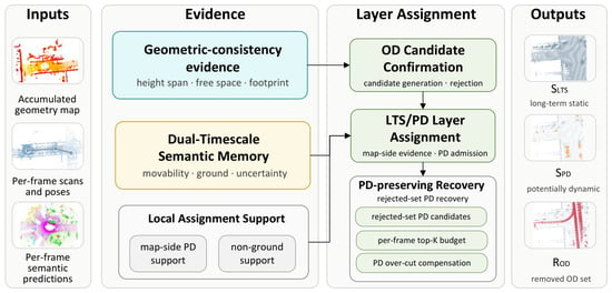
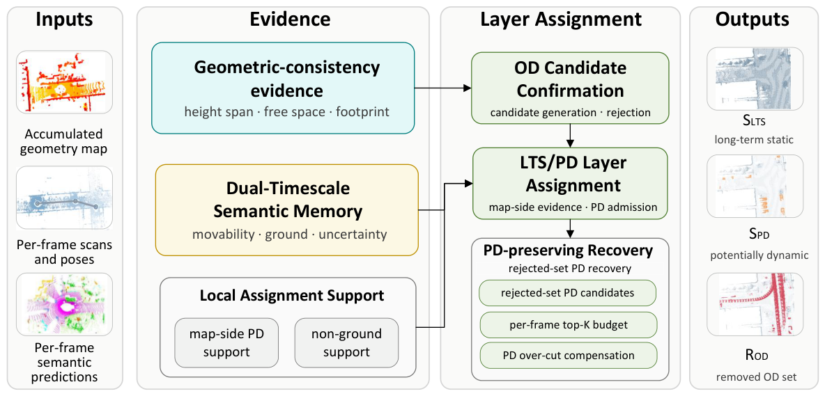
The overall framework is shown in Figure 1. The geometric stage generates OD rejection evidence. The semantic stage performs initial LTS/PD layering within the geometrically retained content. The recovery stage selectively restores only high-confidence PD regions inside the geometric rejection set. Rejected content not selected by PD recovery remains in . The final output consists of three mutually disjoint voxel sets: , , and .
Figure 1.
Overview of the proposed method for LTS/PD/OD layer assignment within long-term LiDAR map maintenance. The method first generates geometric OD evidence from map-to-scan inconsistency, then builds dual-timescale map-side semantic evidence for LTS/PD assignment, and finally performs PD-preserving risk-controlled recovery only inside the geometric rejection set. The final output consists of three mutually disjoint voxel sets: , , and .
3.2. Geometry-Guided OD Candidates and Point-Level Confirmation
OD suppression first relies on geometric evidence. If local occupancy in the naively accumulated map is observed as free space in the current scan, the region may contain transient observed-dynamic artifacts. We use ERASOR-style pseudo-occupancy consistency as the basis for region-level candidate generation [5]. The geometric stage provides OD candidates and rejection evidence, while point removal is decided by point-level confirmation.
Let be the current scan in the query frame , be the complete naively accumulated map in the global frame G, and be the current pose. We crop a local submap from the accumulated map and compare both sets in :
Here denotes the query-frame crop region transformed to G. Since point confirmation later requires current-frame observed-free evidence, points supported by a current range endpoint are not removed by self-support alone.
The local region in is divided into fixed-size BEV query columns . For the i-th column, define
For supported columns, we estimate robust lower and upper heights by quantiles:
where .
The scan-to-map pseudo-occupancy ratio and map-side height excess are
A small with positive indicates that the accumulated map has vertical support that is absent in the current scan.
We restrict OD candidate generation to reliable comparison columns. The bottom-height difference is
Map-side high points are defined as
Let denote the horizontal footprint coverage between these map-side high points and the scan-side low-height support. This term checks whether the missing high map structure is horizontally supported by low-height scan evidence in the same column; it prevents a column from being treated as a reliable free-space conflict when the scan provides no local footprint support for comparison. Then the valid geometric columns are
For any point expressed in , let be its scan angular or range-image bin and be the valid bin set. We write when falls before the valid range endpoint in the same bin for the fixed range-image free-space test. The point-level observed-free indicator is
The region-level free-space confidence is
Region-level OD candidates are selected by a fixed ERASOR-style column predicate, denoted by , that combines height-span deficit, positive map-side height excess, and region-level observed-free support:
For each candidate column, the corresponding global-frame map points are
For any , denote
Before point removal, low-height structures are protected by
where indicates sufficient neighboring map support in the same low-height band. Intuitively, this gate preserves continuous low structures close to the current scan-side ground reference, such as ground-adjacent surfaces or curbs, when higher map points are observed as free space.
The protected set and confirmed geometric OD set are
Finally, geometric OD evidence is aggregated with protection priority:
Thus, and provide the geometric retained and rejection sets for subsequent semantic layering and recovery.
The discrete 2D subcell implementation of and the neighbor-count implementation of are provided in Supplementary Section S1.
3.3. Dual-Timescale Map-Side Semantic Evidence
Compared with OD, PD relies less on single-frame geometric inconsistency. Movable-category objects may remain geometrically stable for a long time, while still not belonging to the same long-term static layer as roads, buildings, poles, and other persistent background structures. We therefore construct map-side semantic evidence on the voxel grid to convert per-frame semantic observations into map-side movability evidence.
Let denote the set of non-ignored semantic labels. Valid semantic classes are folded into , , and , denoting movable, ground-like, and residual classes, respectively. Ignored labels are excluded from the valid semantic support and tracked separately as ignored-label support. The class indicates category-level movability, not current-frame motion.
For points falling into voxel v, we collect
where is the valid semantic support excluding ignored points, and is the ignored-label support. The residual support is computed by difference, . When , the valid semantic ratio of the current observation is
For each voxel v, we maintain a slow semantic state and a fast semantic state:
The slow state represents long-term semantic support, while the fast state estimates recent semantic composition. To avoid domination by a single dense frame, the observation is first capped and then integrated under a finite-capacity memory constraint:
Here controls the single-frame support cap, and controls the memory capacity. The superscript 0 denotes the slow state before adaptive composition adjustment. Since clipping, capacity normalization, and later adjustment may introduce fractional values, the entries of are treated as semantic support masses.
When voxel v receives a valid semantic observation, the fast state is updated by an observation-adaptive EMA:
Here denotes the valid two-class ratio simplex. The projection keeps the movable and ground ratios valid. The update weight is bounded and increases with the current valid support. If no valid observation is available, the fast state is held and its age is increased to measure temporal staleness.
3.3.1. Persistent Fast–Slow Discrepancy
From the pre-adjusted slow state, we compute the long-term semantic ratio and compare it with the recent estimate:
The support-aware discrepancy is
Here indicates whether the slow state has sufficient semantic support and the fast state has been effectively initialized. The adaptation eligibility indicator is a combined reliability gate for semantic-memory adaptation. It is the conjunction of three conditions: a valid current semantic observation, sufficient accumulated support for a support-admissible comparison, and an acceptable ignored-label ratio. Thus, fast–slow correction is permitted only when the current observation and accumulated semantic support are both trustworthy.
To avoid reacting to isolated segmentation errors, we maintain consecutive-disagreement and consecutive-agreement counts, and . The persistence indicator is
Thus, a voxel enters the adaptation state only after the recent estimate remains inconsistent with the long-term estimate for multiple admissible observations, and exits this state after the two estimates become consistently compatible again.
3.3.2. Reliability-Constrained Slow-State Adaptation
Once a persistent discrepancy is detected, the recent estimate can adjust the semantic composition of the slow state with bounded strength. Let
We define
where is the maximum adaptation strength. The adjusted movable/ground support is
This adjustment changes only the movable/ground composition, while preserving the valid support mass and ignored-label support.
3.3.3. Reliability-Weighted Semantic Evidence Estimation
After adaptation, the slow semantic ratio is
The final map-side semantic estimate combines the long-term and recent ratios according to the reliability of the recent estimate:
Here , , and account for semantic uncertainty, temporal freshness, and persistent fast–slow discrepancy, respectively. The final semantic ratio is
After the sequence ends, , , , and the residual ratio are used as the map-side semantic evidence of voxel v. This evidence is combined with observation support and local geometric consistency for the final PD estimation.
The concrete definitions of , , , , , and the reliability factors are provided in Supplementary Section S2.
3.4. LTS/PD Layering from Geometric and Semantic Evidence
Given the geometrically retained map content and the map-side semantic evidence, we derive an initial decomposition of the retained content into a potentially dynamic (PD) layer and a long-term static (LTS) candidate layer. This assignment estimates category-level movability in retained map structures, rather than current-frame motion, using sufficient observation support and local geometric support.
For simplicity, the final time index T is omitted below. At the PD resolution, the retained voxel set is defined as
with voxel-level map support
We formulate PD admission as a support- and geometry-gated voxel-level evidence-consensus test. A retained voxel is admitted to the PD layer only when observation support, movable-category semantic evidence, and non-ground local geometry agree. We write this criterion as
In the reported main setting, the support and semantic gates are implemented as
The local non-ground geometry gate is defined in Supplementary Section S1.3.
The PD voxel set is then defined as
This voxel-level decision induces the initial point-level PD layer
and the complementary LTS candidate
3.5. PD-Preserving Risk-Controlled Recovery Inside Geometric Rejection Regions
Free-space geometric evidence is effective for suppressing OD points, but it can also over-cut boundary regions of stationary movable objects. We therefore perform PD-preserving recovery only inside the fixed geometric rejection set . Rejected content that is not selected by PD recovery remains in the removed OD set during final layer construction.
3.5.1. Map-Side PD Support Gates
Let b denote a recovery voxel, and let be the set of decision voxels spatially intersecting b. The map-side PD support ratio is
A recovery voxel is not selected from semantic evidence alone. For each frame t, we also require a non-ground criterion and a range/hit-consistency criterion . The former compares the rejected points in b with a local low-height reference estimated from the current scan, while the latter applies the configured valid-range and re-observation consistency conditions.
The per-frame PD recovery candidates are
3.5.2. Budgeted Per-Frame Recovery Selection
To bound false recovery, eligible candidates are ranked under a per-frame recovery budget by a fixed hit-consistency priority score . The score prioritizes repeated exact re-observation and stable hit evidence after the map-side PD support and non-ground geometry gates have been satisfied.
Let denote the set of up to K candidates in with the highest scores. The recovered PD-support voxels are
and the corresponding recovered PD points are
The budget K is applied before the union over frames and is therefore a per-frame recovery bound, not a global sequence-level cap. Parameterized definitions of , , and are given in Supplementary Section S3.
3.6. Final Layer Construction
After geometric OD suppression, initial LTS/PD assignment, and PD-preserving recovery within geometrically rejected regions, the resulting PD and LTS point sets are projected onto the evaluation voxel grid with resolution . Let denote the accumulated-map voxel set on this grid, and let map a point set to its occupied voxels. The final three-layer representation is constructed as
This construction imposes a voxel-level priority order among the three outputs. Voxels supported by the initial PD assignment or by PD recovery are first assigned to . Initial LTS candidate voxels are then assigned to only if they have not already been claimed by the PD layer. Unrecovered rejected voxels are not restored to the LTS layer; they remain in the removed observed-dynamic set . Consequently, , , and form a mutually exclusive partition of on the voxel grid.
4. Results
4.1. Experimental Setup and Evaluation Protocol
4.1.1. Datasets and Evaluation Protocol
SemanticKITTI provides LiDAR sequences with pointwise semantic annotations [38]. We used its class taxonomy to construct the semantic folding used by both the method and the evaluation. In this folding, included car, truck, other-vehicle, bicycle, motorcycle, person, bicyclist, and motorcyclist; included road, sidewalk, parking, other-ground, and terrain; all other valid classes were folded into . Moving-state labels (252–259) were used only as observed-dynamic (OD) reference labels for evaluation. These labels correspond to moving-car, moving-bicyclist, moving-person, moving-motorcyclist, moving-on-rails, moving-bus, moving-truck, and moving-other-vehicle, respectively. Potentially dynamic (PD) reference labels were derived from the same taxonomy: points from movable semantic classes were assigned to PD when they were not annotated with moving-state labels in the corresponding sequence. We therefore used SemanticKITTI under a controlled in-sequence LTS/PD/OD layer-assignment protocol.
We used a fixed tuning/holdout protocol. The tuning split consisted of seq00 [4390, 4530] and seq05 [2350, 2670], while the holdout split consisted of seq02 [860, 950] and seq07 [630, 820]. These ranges are raw frame-index ranges; the experiments used fixed sampled frame lists. For SemanticKITTI, every second raw frame was used, giving 71, 161, 46, and 96 used scans for seq00, seq05, seq02, and seq07, respectively. All methods used the same sampled frame lists within each reported scope. The holdout split was used for the main SemanticKITTI evaluation after tuning. To compare with public single-layer map-cleaning outputs with a common retained-map format, we also followed the commonly adopted SemanticKITTI dynamic-object-removal/map-cleaning evaluation protocol used in representative comparisons [5,7,26], where predefined snippets from seq00, seq01, seq02, seq05, and seq07 provide comparable retained-map metrics. With our LTS/PD/OD reference construction, the seq01 snippet contains no PD-reference content, so PD-retention and PD-overcutting diagnostics would be uninformative. We therefore report the four non-empty-PD snippets from seq00, seq05, seq02, and seq07. This retained-map baseline-comparison subset includes both tuning and holdout sequences, so it is reported for the single-layer retained-map setting rather than mixed with the main holdout LTS/PD/OD results. The operating points are fixed by the tuning protocol and are not retuned for this retained-map baseline-comparison table. The resulting evaluation scopes are summarized in Table 1.
Table 1.
Evaluation scopes used in the experiments.
The reported path lengths were accumulated over the scans used in the experiments. For SemanticKITTI, the stride values specify the fixed scan lists used in each scope. Apollo SouthBay was used as a fixed pooled transfer-check set for qualitative cross-dataset evaluation without retuning, with binary map-quality scores and a predicted-movable layer diagnostic reported as supporting evidence. The selected subsequences are urban road-scene mobile-LiDAR segments containing road, sidewalk, and parking areas, persistent background structures such as buildings and poles, and traffic- or parking-related movable objects. The SemanticKITTI ranges are compact local snippets used for controlled LTS/PD/OD evaluation, while the pooled Apollo SouthBay set covers longer urban traverses used only for qualitative transfer assessment, with binary map-quality scores as supporting evidence.
Apollo SouthBay provides LiDAR scans, high-accuracy poses, and binary static/dynamic annotations [4,39,40]. These annotations support the qualitative transfer check and the calculation of binary map-quality scores. Quantitative LTS/PD/OD layer-assignment metrics were evaluated on SemanticKITTI, where pointwise semantic annotations were available.
4.1.2. Semantic Input
The main experiments used per-frame predicted base semantic classes as input. Moving-state labels were never provided as input to the method. Semantic predictions were generated by MinkowskiNet [41] implemented in OpenPCSeg [42] (Git commit 2d4ab1e). The semantic-network training samples did not include the frame segments used for map evaluation, and the predictor was then held fixed for all experiments. It output base class information but not moving-state labels; observed dynamics were identified by the geometric consistency module.
4.1.3. Evaluation Metrics
All main-text metrics were computed at the 0.2 m voxel level after excluding ignored, unlabeled, and invalid evaluation classes. Unless otherwise stated, aggregate scores used pooled voxel counts over all evaluation segments.
Reference and output sets. We first constructed mutually exclusive SemanticKITTI reference sets. Voxels containing moving-state labels were assigned to . Among the remaining voxels, non-moving movable classes define , and all other valid voxels define . For single retained-map evaluation, we used because both structural static voxels and stationary movable voxels should remain in the retained map. For the proposed output, denotes the long-term static layer, the explicit PD layer, and the removed observed-dynamic set. The full retained map is
and , , and are mutually disjoint within the valid evaluation volume. We use the normalized overlap rate
Retained-map and layered metrics. The common retained-map quality is evaluated by
measures retention in the full retained map, and measures OD-reference suppression. For Apollo SouthBay, the same retained-map formulas were applied to the binary references and ; the resulting metrics are denoted and . Apollo binary annotations do not define a separate LTS/PD reference split, so LTS/PD layer-assignment metrics are not reported for Apollo.
For SemanticKITTI, where LTS/PD/OD reference sets are available under the controlled in-sequence protocol, we additionally report
measures whether LTS-reference voxels remain specifically in the LTS layer. measures PD-reference voxels retained in the explicit PD layer, and measures PD-reference voxels removed as OD.
PD-layer diagnostics. For SemanticKITTI, we further characterized the composition of using
measures PD-layer purity, reports OD-reference leakage into the PD layer, and gives the absolute number of over-cut PD voxels.
Single-layer comparisons. For single-layer comparisons, denotes the retained baseline map; for the proposed method, . The retained-map metrics above were computed with in place of . Because single-layer outputs do not provide an explicit , is omitted. We additionally report
which measures PD-reference retention in the single retained map.
4.1.4. Baselines and Implementation Details
We compared with representative static mapping and dynamic-object removal baselines, including ERASOR, Remove-then-Revert, Peopleremover, and OctoMap [5,6,43,44]. For these baselines, we used the publicly released map outputs directly. To test whether a single retained-map cleaner can be converted into a layered output by semantic post-processing, we additionally constructed an ERASOR-based relabeling control. Predicted semantic labels were projected onto ERASOR’s retained voxels and used only to split the retained map into LTS and PD labels; ERASOR’s retained geometry and removed set were kept unchanged.
Since most existing methods output a single retained map and do not explicitly provide a PD layer, evaluation was conducted in two parts. We first compared all methods using and under the same evaluation protocol to assess retained static structure and OD suppression. For layered outputs from the proposed method, we additionally report , , and , which characterize LTS/PD assignment beyond what can be expressed by a single-map output.
Unless otherwise stated, the experiments used per-frame semantic predictions from the predictor selected on the tuning split, with full dual-timescale map-side semantic memory as the default semantic-evidence model. Targeted ablations were introduced where needed to isolate slow-state adaptation, map-side semantic accumulation, and PD-preserving recovery.
The main text reports two fixed per-frame PD-recovery budgets, selected on the tuning split and then held fixed for evaluation: a balanced setting with and a retention-prioritized setting with . Both used the same semantic predictor, geometric OD suppression, and dual-timescale semantic memory. The full parameter groups and reported settings are summarized in Supplementary Section S3.3 and Tables S2–S4. Post hoc diagnostic sensitivity checks, performed after fixing the operating points on the tuning split and not used for holdout retuning, are reported in Supplementary Section S3.4 and Tables S5–S6.
4.2. Main Layered Decomposition Results with Predicted Semantics
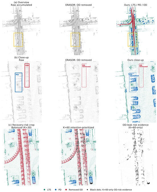
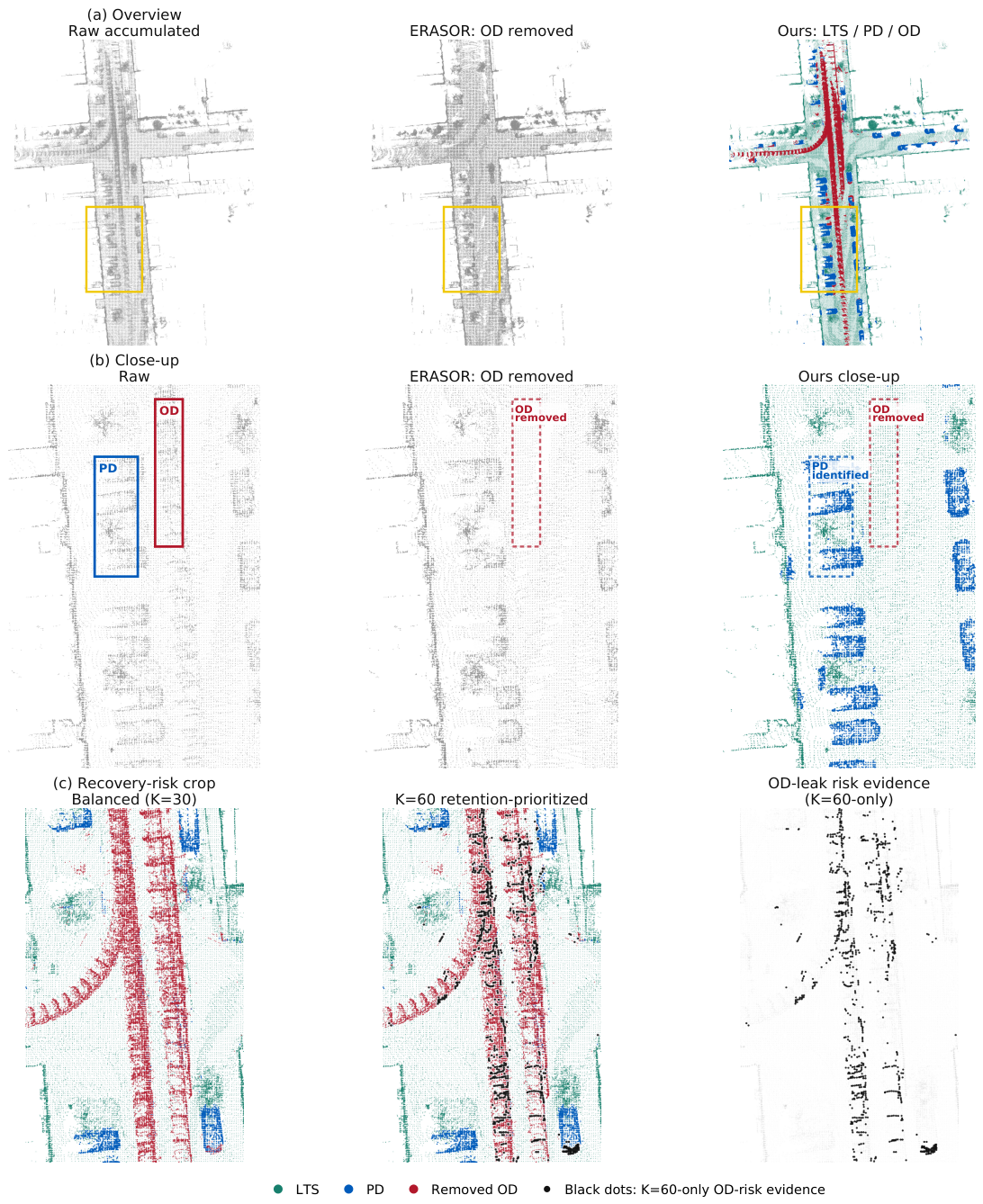
Figure 2 shows a representative SemanticKITTI seq07 qualitative result. The same-scene overview and local close-up make the raw map, ERASOR single-layer baseline, and proposed layered output visually comparable, while the recovery-risk crop shows the OD-risk pattern associated with the retention-prioritized setting. Table 2 summarizes the holdout results under predicted semantic input conditions. The table reports the unrecovered dual-memory output and the two selected PD-preserving recovery operating points. The unrecovered output represents the main LTS/PD/OD assignment before PD-preserving boundary redistribution, while the two recovery operating points were selected on the tuning split and then fixed for holdout evaluation.
Figure 2.
Qualitative SemanticKITTI result under predicted semantic input conditions. Panels (a,b) compare the raw accumulated map, the ERASOR single-layer OD-removal baseline, and the proposed LTS/PD/OD layered output on the same scene and local region. ERASOR is shown as a single-layer retained/removed baseline output. Panel (c) shows a recovery-risk case, where the -only black points visualize OD-risk evidence associated with the retention-prioritized setting. The yellow box in panel (a) marks the local region enlarged in panel (b).
Table 2.
Main SemanticKITTI results on the holdout split under predicted semantic input conditions. “Dual memory before recovery” omits the recovery stage. The last two rows show the default balanced setting () and the retention-prioritized setting (). is computed on the full retained map, whereas is computed only on the LTS layer. All reported metric values are percentages.
PD-preserving risk-controlled recovery mainly trades for . Starting from the dual-memory output, the default balanced setting () increases to and reduces to , while still keeping above . The retention-prioritized setting () further increases to and reduces to , at the cost of lowering to . The small increase in after recovery reflects restoration of over-cut voxels to , primarily through the explicit PD layer. The values show that this retained-map gain does not correspond to higher LTS-layer reference recall: changes from before recovery to and for the two recovered operating points. These two operating points span the trade-off between PD retention and OD suppression.
Table 3 reports the voxel composition of the final layer. The default balanced setting achieves with . The retention-prioritized setting assigns more voxels to , increasing the PD-reference count from 22,657 to 23,016. However, it also admits more LTS-reference and OD-reference voxels, reducing to and increasing to . The LTS-reference fraction inside is for and for . This quantifies the expected trade-off between expanded PD retention, PD-layer purity, and OD suppression.
Table 3.
PD-layer composition on the holdout split under predicted semantic input conditions. PD reference, LTS reference, and OD reference denote voxel counts inside the final layer according to the evaluation reference category. The precision and leakage columns are percentages.
4.3. Mechanism Analysis
The main results combine two components: dual-timescale map-side semantic memory forms the initial LTS/PD assignment, and PD-preserving risk-controlled recovery selectively restores high-confidence PD regions from the geometric rejection set. This section separates these roles. The first two analyses disable PD-preserving recovery and evaluate two effects of the dual-timescale memory: slow-state adaptation under conflicting labels, and map-side semantic accumulation under temporal sparsification conditions. The final analysis re-enables recovery and quantifies its boundary redistribution between retained PD content and the removed OD set.
The following analyses focus on settings where the dual-timescale semantic memory is most informative: conflicting semantic predictions and temporal sparsification.
4.3.1. Effect of Slow-State Adaptation Under Semantic Conflict Conditions
For random-degradation experiments, all methods were evaluated with identical perturbation patterns generated from fixed seeds. We report the high-conflict label-flipping setting . PD-preserving recovery was disabled to isolate the contribution of slow-state adaptation within the dual-timescale memory.
The per-sequence results show a larger effect on seq02, where increases by 2.833 percentage points, indicating that slow-state adaptation is especially useful when semantic evidence is more vulnerable to conflicts. On the more stable seq07, the full dual-memory model still shows a positive gain of 0.298 percentage points.
In this isolated comparison, remains unchanged within rounding between the dual-memory model without slow-state adaptation and the full dual-memory model. Table 4 therefore reports as the retained-PD measure and as context for boundary over-cutting. These results indicate that slow-state adaptation mainly strengthens PD separation under conflicting semantic predictions, rather than directly correcting boundary over-cutting. Boundary redistribution is analyzed separately in the PD-preserving recovery stage.
Table 4.
Per-sequence effect of slow-state adaptation on the holdout split under label flipping conditions with . reports retained PD-reference content, while reports the boundary over-cutting cost. “No-adapt. dual” denotes the dual-memory model without slow-state adaptation; the gain column reports the full dual-memory model minus this no-adaptation dual-memory model. and entries are percentages, and the gain column is reported in percentage points. PD-preserving recovery is disabled to isolate the adaptation effect.
4.3.2. PD Evidence Retention Under Temporal Sparsification Conditions
Beyond slow-state adaptation, we evaluated whether map-side semantic accumulation can preserve PD cues when framewise predictions are temporally thinned. PD-preserving recovery remains disabled. When the sparsification ratio is , endpoint-count voting and fast-memory-only updating drop to and , respectively. In contrast, the full dual-memory model retains substantially more PD evidence (). At the stronger thinning level , the full dual-memory model still keeps , whereas the two weaker memory settings drop below 47%. These results indicate that map-side semantic accumulation across frames is essential for temporally sparse semantic predictions, with the dual-timescale design providing the reported retained-PD behavior. The temporal-sparsification results are summarized in Table 5.
Table 5.
PD evidence retention under temporal sparsification conditions on the holdout split before PD-preserving recovery. Reported values are percentages. remains for all settings and is therefore omitted from the table.
4.3.3. PD-Preserving Recovery as Boundary Redistribution
After the main layering stage, we introduced the PD-preserving risk-controlled recovery described in Section 3. This analysis views recovery as a boundary-redistribution step applied to the same unrecovered layered output. The default balanced and retention-prioritized operating points denote two PD-recovery settings selected on the tuning split and then held fixed on the holdout split.
Table 6 reports the unrecovered output and two representative recovery settings. As recovery becomes more retention-oriented, increases, and decreases, while drops. The balanced setting provides a moderate trade-off, whereas the retention-prioritized setting further improves PD retention at the cost of lower OD suppression.
Table 6.
Boundary redistribution by PD-preserving risk-controlled recovery on the holdout split. Recovery reduces and improves , at the cost of lower . All reported metric values are percentages.
The separate column distinguishes retained-map gains from changes in LTS-layer reference recall. The PD-preserving recovery stage can raise by moving over-cut voxels back into the retained map, especially into , while slightly decreases from 95.344 before recovery to 95.318/95.317 after recovery.
4.4. Additional Evaluation of Layered Map Quality
Single-Layer Collapsed Comparison with Map-Cleaning Baselines
Because public map-cleaning baselines provide a single retained map, we collapsed the proposed layered output into the retained map and evaluated all methods using the single-layer metrics defined above. Table 7 uses the retained-map baseline-comparison subset defined in Section 4.1.1. For baseline methods, denotes their single retained map. Because these baselines do not produce a PD layer, was used only as a retained-map diagnostic: it measured how much PD-reference content remains in the single map, not the quality of a PD layer.
Table 7.
Single-layer collapsed comparison on the SemanticKITTI shared subset. Metrics are defined in Section 4.1.3. All reported metric values are percentages. For all three reported quantities, upward arrows indicate that higher values are preferred, and bold values denote the highest value in each column.
The proposed method achieves the highest and recall. OctoMap obtains the highest , while ERASOR and Peopleremover also show stronger OD suppression but with lower static retention or PD-in-map recall.
Because the ERASOR-based relabeling control keeps ERASOR’s geometry unchanged, its single-layer scores are identical to ERASOR and are therefore not listed as a separate baseline in Table 7. Its explicit-layer scores are and , indicating that semantic relabeling can assign only retained voxels and cannot recover PD-reference content already removed by the geometric cleaner.
4.5. Runtime and Transfer Analysis
4.5.1. Runtime Analysis
Runtime was measured as wall-clock time for per-frame layer-assignment updates over the holdout split, using precomputed semantic input and excluding semantic-network training, semantic inference, disk I/O, visualization, and offline metric evaluation. The repeated operations included in this timing were geometric OD evidence generation from map-to-scan inconsistency, auxiliary hit/free-space statistic accumulation for recovery, dual-timescale map-side semantic-memory update, initial LTS/PD assignment with PD admission, PD-preserving risk-controlled recovery inside the geometric rejection set, and projection to the final , , and output layers. The timed layer-assignment stage was run on an AMD Ryzen 9 9950X CPU with 64 GB RAM.
“Dual memory before recovery” has mean and 95th-percentile wall-clock times of 86.711 and 120.413 ms, respectively. With PD-preserving risk-controlled recovery, the default balanced () and retention-prioritized () operating points require 181.548/224.645 ms and 168.819/218.234 ms, respectively. These values correspond to an average per-frame layer-assignment update rate of roughly 5–6 Hz under precomputed semantic input conditions. These timings characterize the layer-assignment stage after semantic prediction, with full end-to-end throughput depending on perception and I/O integration.
4.5.2. Qualitative Transfer to Apollo SouthBay Without Retuning
For Apollo, we examined whether the fixed configuration selected on the SemanticKITTI tuning split can produce a coherent layered output without retuning. Voxels folded into the predicted class are reported as a predicted-movable set, since Apollo annotations cannot distinguish long-term static structures from stationary movable content. The same fixed semantic predictor and the same folding rule as in the SemanticKITTI experiments were used, without retraining or parameter retuning on Apollo.
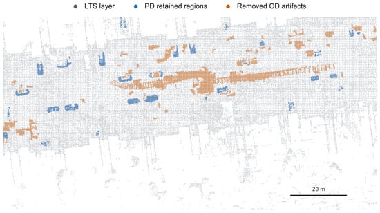
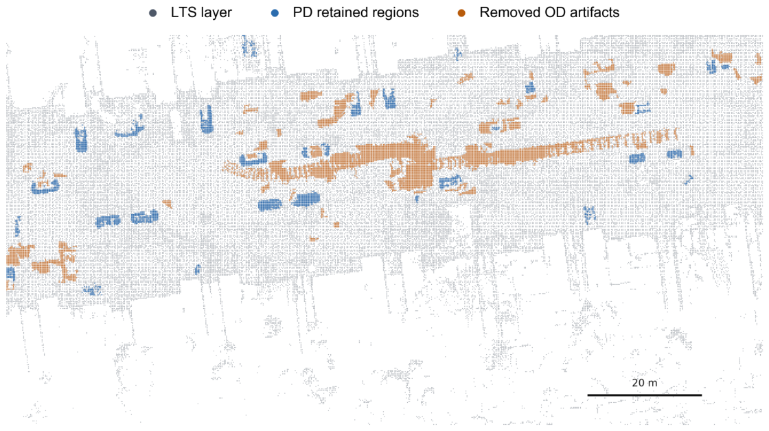
Figure 3 illustrates the qualitative transfer result. The predicted-movable layer appears as localized retained regions rather than being uniformly absorbed into the LTS layer or removed as OD artifacts. This visual result suggests that the layered decision process remains applicable to another urban LiDAR dataset using the same configuration.
Figure 3.
Qualitative Apollo SouthBay transfer result. Gray denotes the long-term static layer, blue denotes predicted-movable regions retained as an explicit layer, and orange denotes removed observed-dynamic artifacts.
Table 8 reports the Apollo transfer results. The first two columns report binary map-quality metrics and should not be interpreted as validation of true LTS/PD separation. The last column is an Apollo-specific diagnostic based on predicted movable labels; it is not an annotation-based PD accuracy metric. The dual-memory output before recovery achieves , with 13.762% of predicted-movable voxels retained in the explicit PD layer. With PD-preserving recovery, increases to 98.256%, the predicted-movable fraction in increases to 14.163%, and remains 95.771%.
Table 8.
Supporting Apollo SouthBay transfer results. The first two columns report binary map-quality metrics; the last column reports a predicted-movable layer diagnostic. For the two binary map-quality metrics, an upward arrow indicates that a higher value is preferred.
5. Discussion
The results support the proposed LTS/PD/OD decomposition under per-frame predicted semantic input conditions. The final operating points expose a PD-retention versus OD-suppression trade-off mainly through PD-preserving boundary redistribution. The mechanism analysis further shows the role of the dual-timescale semantic memory under conflicting or temporally sparse semantic predictions.
The mechanism analysis identifies two effects of the dual-timescale semantic memory: slow-state adaptation improves PD separation under conflicting semantic predictions, while map-side semantic accumulation preserves PD cues under temporal sparsification compared with simpler endpoint-count or fast-memory-only alternatives. PD-preserving recovery then acts as a boundary-redistribution stage that increases and reduces , with lower OD suppression at more retention-oriented operating points.
The single-layer collapsed comparison shows that the layered output can be compressed into a conventional retained map with stronger static and PD retention, although it does not maximize OD suppression. The ERASOR-based relabeling control further shows that adding semantics after a fixed retained-map cleaner cannot recover PD content already removed by the upstream geometric stage.
The framework uses ERASOR-style pseudo-occupancy consistency as a fixed source of geometric candidate evidence. This design isolates how binary retain/remove evidence is converted into LTS/PD/OD layers through semantic memory and PD-preserving recovery. The formulation is compatible with alternative candidate detectors or online free-space modules.
For practical deployment, the required inputs are synchronized LiDAR scans, pose estimates from SLAM, odometry, or GNSS/INS, and per-frame semantic labels or probabilities. Semantic predictions may be produced online on a GPU or provided by offline preprocessing, while the reported runtime isolates the subsequent layer-assignment pipeline. This pipeline can run on an onboard workstation or an edge/offline mapping server; accordingly, the communication load depends on whether the deployment transfers sensor-level data or compact preprocessed layer-assignment information.
Two limitations remain. First, PD-preserving recovery reduces PD over-cutting inside the geometric rejection set, but it does not attempt general static-structure repair; fine-scale or weakly observed static structures may therefore remain in the removed OD set. Second, the current experiments focus on road-scene mobile LiDAR. SemanticKITTI supports controlled in-sequence LTS/PD/OD reference construction rather than true multi-session persistence annotation, and Apollo SouthBay provides only transfer observations based on binary annotations. Broader multi-session benchmarks with richer map-side semantic supervision are needed for more comprehensive validation.
6. Conclusions
This paper formulates the LTS/PD/OD layer-assignment problem within long-term LiDAR map maintenance for geometry-only maps with per-frame semantic predictions. The proposed layer-assignment framework combines geometric candidate detection, dual-timescale map-side semantic memory, PD admission, and PD-preserving risk-controlled recovery to separate long-term static support, potentially dynamic content, and removed observed-dynamic artifacts.
Experiments on SemanticKITTI show that, under the in-sequence evaluation protocol, the framework improves PD retention and reduces PD over-cutting with a controllable OD-suppression trade-off. Mechanism analysis indicates that the dual-timescale semantic memory helps preserve PD evidence through slow-state adaptation under semantic conflicts and map-side semantic accumulation under temporal sparsification. PD-preserving recovery provides boundary redistribution with an explicit OD-suppression cost.
The single-layer collapsed comparison and qualitative Apollo SouthBay transfer observations further support the layered output as a more explicit representation than a conventional single retained-map cleaning result, while broader multi-session benchmarks remain necessary for more comprehensive validation.
Supplementary Materials
The following supporting information can be downloaded at: https://www.mdpi.com/article/10.3390/rs18142385/s1.
Author Contributions
Conceptualization, X.C. and B.S.; methodology, X.C.; software, X.C.; validation, X.C.; formal analysis, X.C.; investigation, X.C.; resources, B.S.; data curation, X.C.; writing—original draft preparation, X.C.; writing—review and editing, X.C. and B.S.; visualization, X.C.; supervision, B.S.; project administration, B.S.; funding acquisition, B.S. All authors have read and agreed to the published version of the manuscript.
Funding
This research was supported by the Chinese Academy of Sciences. No specific grant number was assigned.
Data Availability Statement
The public datasets analyzed in this study are available from SemanticKITTI (https://www.semantic-kitti.org/ (accessed on 3 February 2026)) and Apollo SouthBay (https://developer.apollo.auto/southbay.html (accessed on 3 February 2026)). The binary static/dynamic annotation protocol used for Apollo SouthBay follows the dataset resources described by Arora et al. [40]. The fixed evaluation scopes, used-scan counts, path lengths, and key decision parameters used in the reported experiments are provided in the article and Supplementary Material. The relevant code components, trained network weight files, configuration/parameter files, and evaluation scripts including metric-computation code supporting this study are available from the corresponding author upon reasonable request. A cleaned standalone implementation is planned for public release after the related follow-up work is completed.
Acknowledgments
The authors thank the providers of the SemanticKITTI and Apollo SouthBay datasets. During the preparation of this manuscript, the authors used OpenAI’s ChatGPT (GPT-5.5) for translation from Chinese into English and language editing. The authors reviewed and edited the output and take full responsibility for the content of this publication.
Conflicts of Interest
The authors declare no conflicts of interest.
References
- Pomerleau, F.; Krusi, P.; Colas, F.; Furgale, P.; Siegwart, R. Long-term 3D map maintenance in dynamic environments. In Proceedings of the 2014 IEEE International Conference on Robotics and Automation (ICRA), Hong Kong, China, 31 May–5 June 2014; IEEE: Piscataway, NJ, USA, 2014; pp. 3712–3719. [Google Scholar] [CrossRef] [Scilit]
- Kim, G.; Kim, A. LT-mapper: A Modular Framework for LiDAR-based Lifelong Mapping. In Proceedings of the 2022 International Conference on Robotics and Automation (ICRA), Philadelphia, PA, USA, 23–27 May 2022; IEEE: Piscataway, NJ, USA, 2022; pp. 7995–8002. [Google Scholar] [CrossRef] [Scilit]
- Rowell, J.; Zhang, L.; Fallon, M. LiSTA: Geometric Object-Based Change Detection in Cluttered Environments. In Proceedings of the 2024 IEEE International Conference on Robotics and Automation (ICRA), Yokohama, Japan, 13–17 May 2024; IEEE: Piscataway, NJ, USA, 2024; pp. 3632–3638. [Google Scholar] [CrossRef] [Scilit]
- Lu, W.; Zhou, Y.; Wan, G.; Hou, S.; Song, S. L3-Net: Towards Learning Based LiDAR Localization for Autonomous Driving. In Proceedings of the 2019 IEEE/CVF Conference on Computer Vision and Pattern Recognition (CVPR), Long Beach, CA, USA, 15–20 June 2019; IEEE: Piscataway, NJ, USA, 2019; pp. 6382–6391. [Google Scholar] [CrossRef] [Scilit]
- Lim, H.; Hwang, S.; Myung, H. ERASOR: Egocentric Ratio of Pseudo Occupancy-Based Dynamic Object Removal for Static 3D Point Cloud Map Building. IEEE Robot. Autom. Lett. 2021, 6, 2272–2279. [Google Scholar] [CrossRef] [Scilit]
- Kim, G.; Kim, A. Remove, then Revert: Static Point cloud Map Construction using Multiresolution Range Images. In Proceedings of the 2020 IEEE/RSJ International Conference on Intelligent Robots and Systems (IROS), Las Vegas, NV, USA, 25–29 October 2020; pp. 10758–10765. [Google Scholar] [CrossRef] [Scilit]
- Fu, H.; Xue, H.; Xie, G. MapCleaner: Efficiently Removing Moving Objects from Point Cloud Maps in Autonomous Driving Scenarios. Remote Sens. 2022, 14, 4496. [Google Scholar] [CrossRef] [Scilit]
- Gil, H.; Lee, D.; Kim, G.; Kim, A. Ephemerality Meets Lidar-Based Lifelong Mapping. In Proceedings of the 2025 IEEE International Conference on Robotics and Automation (ICRA), Atlanta, GA, USA, 19–23 May 2025; IEEE: Piscataway, NJ, USA, 2025; pp. 3312–3319. [Google Scholar] [CrossRef] [Scilit]
- Woo, S.; Jung, D.; Kim, S.W. No More Potentially Dynamic Objects: Static Point Cloud Map Generation Based on 3D Object Detection and Ground Projection. arXiv 2024, arXiv:2407.01073. [Google Scholar]
- Zhang, J.; Singh, S. LOAM: Lidar Odometry and Mapping in Real-time. In Proceedings of the Robotics: Science and Systems X, Berkeley, CA, USA, 12–16 July 2014. [Google Scholar] [CrossRef] [Scilit]
- Shan, T.; Englot, B. LeGO-LOAM: Lightweight and Ground-Optimized Lidar Odometry and Mapping on Variable Terrain. In Proceedings of the 2018 IEEE/RSJ International Conference on Intelligent Robots and Systems (IROS), Madrid, Spain, 1–5 October 2018; IEEE: Piscataway, NJ, USA, 2018; pp. 4758–4765. [Google Scholar] [CrossRef] [Scilit]
- Shan, T.; Englot, B.; Meyers, D.; Wang, W.; Ratti, C.; Rus, D. LIO-SAM: Tightly-coupled Lidar Inertial Odometry via Smoothing and Mapping. In Proceedings of the 2020 IEEE/RSJ International Conference on Intelligent Robots and Systems (IROS), Las Vegas, NV, USA, 24 October 2020–24 January 2021; IEEE: Piscataway, NJ, USA, 2020; pp. 5135–5142. [Google Scholar] [CrossRef] [Scilit]
- Xu, W.; Zhang, F. FAST-LIO: A Fast, Robust LiDAR-Inertial Odometry Package by Tightly-Coupled Iterated Kalman Filter. IEEE Robot. Autom. Lett. 2021, 6, 3317–3324. [Google Scholar] [CrossRef] [Scilit]
- Xu, W.; Cai, Y.; He, D.; Lin, J.; Zhang, F. FAST-LIO2: Fast Direct LiDAR-Inertial Odometry. IEEE Trans. Robot. 2022, 38, 2053–2073. [Google Scholar] [CrossRef] [Scilit]
- Milioto, A.; Vizzo, I.; Behley, J.; Stachniss, C. RangeNet++: Fast and Accurate LiDAR Semantic Segmentation. In Proceedings of the 2019 IEEE/RSJ International Conference on Intelligent Robots and Systems (IROS), Macau, China, 3–8 November 2019; pp. 4213–4220. [Google Scholar] [CrossRef] [Scilit]
- Cortinhal, T.; Tzelepis, G.; Aksoy, E.E. SalsaNext: Fast, Uncertainty-Aware Semantic Segmentation of LiDAR Point Clouds. In Advances in Visual Computing; Lecture Notes in Computer Science; Springer International Publishing: Cham, Switzerland, 2020; Volume 12510, pp. 207–222. [Google Scholar] [CrossRef] [Scilit]
- Yan, X.; Gao, J.; Zheng, C.; Zheng, C.; Zhang, R.; Cui, S.; Li, Z. 2DPASS: 2D Priors Assisted Semantic Segmentation on LiDAR Point Clouds. In Computer Vision–ECCV 2022; Lecture Notes in Computer Science; Springer: Cham, Switzerland, 2022; pp. 677–695. [Google Scholar] [CrossRef] [Scilit]
- He, M.; Yue, X.; Zheng, Y.; Chen, J.; Wu, S.; Heng, Z.; Zhou, X.; Cai, Y. State of the art and future trends in obstacle-surmounting unmanned ground vehicle configuration and dynamics. Robotica 2023, 41, 2625–2647. [Google Scholar] [CrossRef] [Scilit]
- Yue, X.; Zhang, Y.; Chen, J.; Chen, J.; Zhou, X.; He, M. LiDAR-based SLAM for robotic mapping: State of the art and new frontiers. Ind. Robot. Int. J. Robot. Res. Appl. 2024, 51, 196–205. [Google Scholar] [CrossRef] [Scilit]
- Sun, L.; Yan, Z.; Zaganidis, A.; Zhao, C.; Duckett, T. Recurrent-OctoMap: Learning State-Based Map Refinement for Long-Term Semantic Mapping with 3-D-Lidar Data. IEEE Robot. Autom. Lett. 2018, 3, 3749–3756. [Google Scholar] [CrossRef] [Scilit]
- Jang, S.; Lee, A.J.; Nahrendra, I.M.A.; Myung, H. Chamelion: Reliable Change Detection for Long-Term LiDAR Mapping in Transient Environments. IEEE Robot. Autom. Lett. 2026, 11, 4361–4368. [Google Scholar] [CrossRef] [Scilit]
- Du, Y.; Yang, S.; Wang, L.; Hou, Z.; Cai, C.; Tan, Z.; Chen, M.; Huang, S.S.; Li, Q. RTMap: Real-Time Recursive Mapping with Change Detection and Localization. In Proceedings of the 2025 IEEE/CVF International Conference on Computer Vision (ICCV), Honolulu, HI, USA, 19–25 October 2025; IEEE: Piscataway, NJ, USA, 2025; pp. 28021–28030. [Google Scholar] [CrossRef] [Scilit]
- Lim, H.; Nunes, L.; Mersch, B.; Chen, X.; Behley, J.; Myung, H.; Stachniss, C. ERASOR2: Instance-Aware Robust 3D Mapping of the Static World in Dynamic Scenes. In Proceedings of the Robotics: Science and Systems XIX. Robotics: Science and Systems Foundation, Daegu, Republic of Korea, 10–14 July 2023. [Google Scholar] [CrossRef] [Scilit]
- Zhang, J.; Zhang, Y. ERASOR++: Height Coding plus Egocentric Ratio Based Dynamic Object Removal for Static Point Cloud Mapping. In Proceedings of the 2024 IEEE International Conference on Robotics and Automation (ICRA), Yokohama, Japan, 13–17 May 2024; IEEE: Piscataway, NJ, USA, 2024; pp. 4067–4073. [Google Scholar] [CrossRef] [Scilit]
- Yan, Z.; Wu, X.; Jian, Z.; Lan, B.; Wang, X. RH-Map: Online Map Construction Framework of Dynamic Object Removal Based on 3D Region-Wise Hash Map Structure. IEEE Robot. Autom. Lett. 2024, 9, 1492–1499. [Google Scholar] [CrossRef] [Scilit]
- Fan, T.; Shen, B.; Chen, H.; Zhang, W.; Pan, J. DynamicFilter: An Online Dynamic Objects Removal Framework for Highly Dynamic Environments. In Proceedings of the IEEE International Conference on Robotics and Automation (ICRA), Philadelphia, PA, USA, 23–27 May 2022; IEEE: Piscataway, NJ, USA, 2022; pp. 7988–7994. [Google Scholar] [CrossRef] [Scilit]
- Qian, C.; Xiang, Z.; Wu, Z.; Sun, H. RF-LIO: Removal-First Tightly-coupled LiDAR Inertial Odometry in High Dynamic Environments. In Proceedings of the 2021 IEEE/RSJ International Conference on Intelligent Robots and Systems (IROS), Prague, Czech Republic, 27 September–1 October 2021; pp. 4421–4428. [Google Scholar] [CrossRef] [Scilit]
- Li, C.; Li, W.; Liu, W.; Shu, Y.; Lou, Y. FreeDOM: Online Dynamic Object Removal Framework for Static Map Construction Based on Conservative Free Space Estimation. IEEE Robot. Autom. Lett. 2025, 10, 5577–5584. [Google Scholar] [CrossRef] [Scilit]
- Yoon, D.J.; Tang, T.Y.; Barfoot, T.D. Mapless Online Detection of Dynamic Objects in 3D LiDAR. In Proceedings of the 2019 16th Conference on Computer and Robot Vision (CRV), Kingston, QC, Canada, 29–31 May 2019; IEEE: Piscataway, NJ, USA, 2019; pp. 113–120. [Google Scholar] [CrossRef] [Scilit]
- Chen, X.; Milioto, A.; Palazzolo, E.; Giguère, P.; Behley, J.; Stachniss, C. SuMa++: Efficient LiDAR-based Semantic SLAM. In Proceedings of the 2019 IEEE/RSJ International Conference on Intelligent Robots and Systems (IROS), Macau, China, 3–8 November 2019; IEEE: Piscataway, NJ, USA, 2019; pp. 4530–4537. [Google Scholar] [CrossRef] [Scilit]
- Chen, X.; Li, S.; Mersch, B.; Wiesmann, L.; Gall, J.; Behley, J.; Stachniss, C. Moving Object Segmentation in 3D LiDAR Data: A Learning-Based Approach Exploiting Sequential Data. IEEE Robot. Autom. Lett. 2021, 6, 6529–6536. [Google Scholar] [CrossRef] [Scilit]
- Chen, X.; Mersch, B.; Nunes, L.; Marcuzzi, R.; Vizzo, I.; Behley, J.; Stachniss, C. Automatic Labeling to Generate Training Data for Online LiDAR-Based Moving Object Segmentation. IEEE Robot. Autom. Lett. 2022, 7, 6107–6114. [Google Scholar] [CrossRef] [Scilit]
- Lim, H.; Jang, S.; Mersch, B.; Behley, J.; Myung, H.; Stachniss, C. HeLiMOS: A Dataset for Moving Object Segmentation in 3D Point Clouds From Heterogeneous LiDAR Sensors. In Proceedings of the 2024 IEEE/RSJ International Conference on Intelligent Robots and Systems (IROS), Abu Dhabi, United Arab Emirates, 14–18 October 2024; IEEE: Piscataway, NJ, USA, 2024; pp. 14087–14094. [Google Scholar] [CrossRef] [Scilit]
- Zeng, K.; Shi, H.; Lin, J.; Li, S.; Cheng, J.; Wang, K.; Li, Z.; Yang, K. MambaMOS: LiDAR-based 3D Moving Object Segmentation with Motion-aware State Space Model. In Proceedings of the 32nd ACM International Conference on Multimedia, Melbourne, Australia, 28 October–1 November 2024; ACM: New York, NY, USA, 2024; pp. 1505–1513. [Google Scholar] [CrossRef] [Scilit]
- Miao, Z.; Chen, R.; Cai, Y.; He, B.; Zhao, W.; Shao, W.; Zhang, B.; Zhang, F. Temporal Overlapping Prediction: A Self-supervised Pre-training Method for LiDAR Moving Object Segmentation. In Proceedings of the 2025 IEEE/CVF International Conference on Computer Vision (ICCV), Honolulu, HI, USA, 19–25 October 2025; IEEE: Piscataway, NJ, USA, 2025; pp. 26653–26663. [Google Scholar] [CrossRef] [Scilit]
- Dewan, A.; Caselitz, T.; Tipaldi, G.D.; Burgard, W. Motion-based detection and tracking in 3D LiDAR scans. In Proceedings of the 2016 IEEE International Conference on Robotics and Automation (ICRA), Stockholm, Sweden, 16–21 May 2016; IEEE: Piscataway, NJ, USA, 2016; pp. 4508–4513. [Google Scholar] [CrossRef] [Scilit]
- Dewan, A.; Caselitz, T.; Tipaldi, G.D.; Burgard, W. Rigid scene flow for 3D LiDAR scans. In Proceedings of the 2016 IEEE/RSJ International Conference on Intelligent Robots and Systems (IROS), Daejeon, Republic of Korea, 9–14 October 2016; IEEE: Piscataway, NJ, USA, 2016; pp. 1765–1770. [Google Scholar] [CrossRef] [Scilit]
- Behley, J.; Garbade, M.; Milioto, A.; Quenzel, J.; Behnke, S.; Stachniss, C.; Gall, J. SemanticKITTI: A Dataset for Semantic Scene Understanding of LiDAR Sequences. In Proceedings of the 2019 IEEE/CVF International Conference on Computer Vision (ICCV), Seoul, Republic of Korea, 27 October–2 November 2019; IEEE: Piscataway, NJ, USA, 2019; pp. 9296–9306. [Google Scholar] [CrossRef] [Scilit]
- Apollo Open Platform. Apollo-SouthBay Dataset. 2020. Available online: https://developer.apollo.auto/southbay.html (accessed on 3 February 2026).
- Arora, M.; Wiesmann, L.; Chen, X.; Stachniss, C. Static map generation from 3D LiDAR point clouds exploiting ground segmentation. Robot. Auton. Syst. 2023, 159, 104287. [Google Scholar] [CrossRef] [Scilit]
- Choy, C.; Gwak, J.; Savarese, S. 4D Spatio-Temporal ConvNets: Minkowski Convolutional Neural Networks. In Proceedings of the 2019 IEEE/CVF Conference on Computer Vision and Pattern Recognition (CVPR), Long Beach, CA, USA, 15–20 June 2019; IEEE: Piscataway, NJ, USA, 2019; pp. 3070–3079. [Google Scholar] [CrossRef] [Scilit]
- Liu, Y.; Chen, R.; Li, X.; Kong, L.; Yang, Y.; Xia, Z.; Bai, Y.; Zhu, X.; Ma, Y.; Li, Y.; et al. UniSeg: A Unified Multi-Modal LiDAR Segmentation Network and the OpenPCSeg Codebase. In Proceedings of the 2023 IEEE/CVF International Conference on Computer Vision (ICCV), Paris, France, 1–6 October 2023; IEEE: Piscataway, NJ, USA, 2023; pp. 21605–21616. [Google Scholar] [CrossRef] [Scilit]
- Schauer, J.; Nuchter, A. The Peopleremover—Removing Dynamic Objects From 3-D Point Cloud Data by Traversing a Voxel Occupancy Grid. IEEE Robot. Autom. Lett. 2018, 3, 1679–1686. [Google Scholar] [CrossRef] [Scilit]
- Hornung, A.; Wurm, K.M.; Bennewitz, M.; Stachniss, C.; Burgard, W. OctoMap: An efficient probabilistic 3D mapping framework based on octrees. Auton. Robot. 2013, 34, 189–206. [Google Scholar] [CrossRef] [Scilit]

Disclaimer/Publisher’s Note: The statements, opinions and data contained in all publications are solely those of the individual author(s) and contributor(s) and not of MDPI and/or the editor(s). MDPI and/or the editor(s) disclaim responsibility for any injury to people or property resulting from any ideas, methods, instructions or products referred to in the content. |
© 2026 by the authors. Licensee MDPI, Basel, Switzerland. This article is an open access article distributed under the terms and conditions of the Creative Commons Attribution (CC BY) license.