


Error in Figure
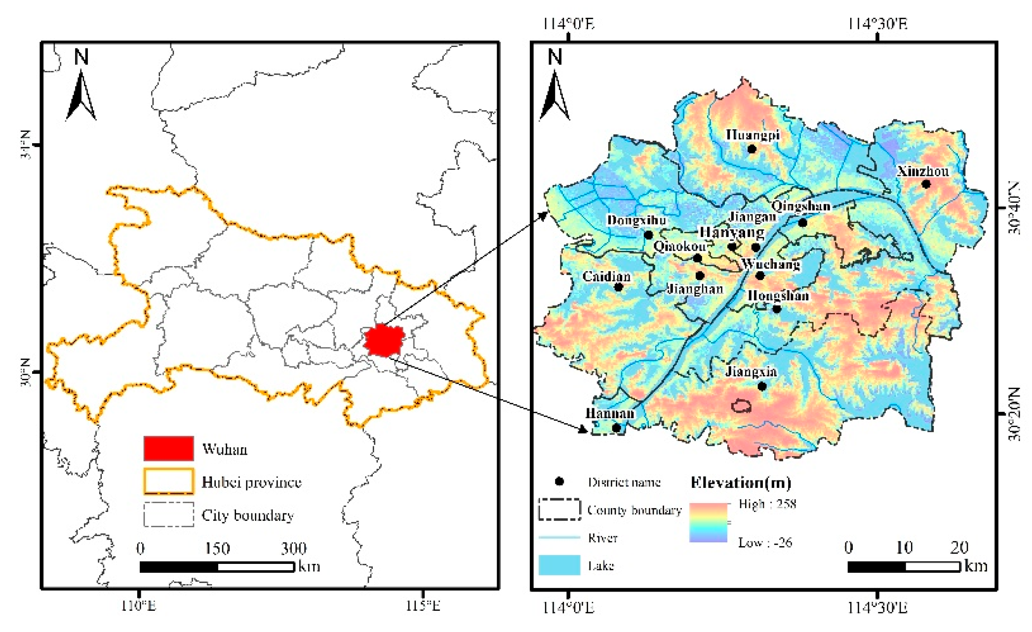
In the original publication [1], there was an issue with Figure 1 as published. The study area in the figure has been updated to improve administrative boundary accuracy, visual clarity, and copyright compliance.
The corrected Figure 1 has been redrawn using publicly available administrative boundary data. The revised figure clearly illustrates the spatial extent of Wuhan’s main urban and peripheral districts as defined in the Wuhan Urban Master Plan (2010–2020).
Text Correction
There was an error in the original publication regarding the clarity and precision of the study area description in Section 2.1 (Study Area).
A correction has been made to Section 2.1 (Study Area):
Wuhan is one of the largest metropolises in China, the core of the Yangtze River Economic Belt and the capital of Hubei Province. The Wuhan Metropolitan Area specified in the Wuhan City Master Planning (2010–2020) was selected as the study area [11]. The Wuhan Metropolitan Area refers to the main agglomeration of urban function and the expansion area of urban development, including built-up areas and the urban fringe [12]. The study area includes all areas of Hanyang, Hongshan, Jiang’an, Jianghan, Qiaokou, Qingshan and Wuchang Districts and parts of Caidian, Dongxihu, Hannan, Huangpi, Jiangxia and Xinzhou Districts, covering an area of 4398.83 km2 [13] (Figure 1).
References
With this correction, one additional reference [2] has been added to support the revised study area description. The numbering of references has been updated accordingly throughout the manuscript.
The authors state that the scientific conclusions are unaffected. This correction was approved by the Academic Editor. The original publication has also been updated.
References
- Tu, S.; Zhan, Q.; Qiu, R.; Yu, J.; Qubi, A. A Study on Urban Built-Up Area Extraction Methods and Consistency Evaluation Based on Multi-Source Nighttime Light Remote Sensing Data: A Case Study of Wuhan City. Remote Sens. 2025, 17, 2879. [Google Scholar] [CrossRef] [Scilit]
- Yu, P.; Zhang, S.; Yung, E.H.K.; Chan, E.H.W.; Luan, B.; Chen, Y. On the urban compactness to ecosystem services in a rapidly urbanising metropolitan area: Highlighting scale effects and spatial non–stationary. Environ. Impact Assess. Rev. 2022, 96, 106975. [Google Scholar] [CrossRef] [Scilit]
Disclaimer/Publisher’s Note: The statements, opinions and data contained in all publications are solely those of the individual author(s) and contributor(s) and not of MDPI and/or the editor(s). MDPI and/or the editor(s) disclaim responsibility for any injury to people or property resulting from any ideas, methods, instructions or products referred to in the content. |
© 2026 by the authors. Licensee MDPI, Basel, Switzerland. This article is an open access article distributed under the terms and conditions of the Creative Commons Attribution (CC BY) license.