Abstract
Accurate delineation of urban built-up areas is critical for urban monitoring and planning. We evaluated the performance and consistency of three widely used methods—thresholding, multi-temporal image fusion, and support vector machine (SVM)—across three major nighttime light (NTL) datasets (DMSP/OLS, SNPP/VIIRS, and Luojia-1). We developed a unified methodological framework and applied it to Wuhan, China, encompassing data preprocessing, feature construction, classification, and cross-dataset validation. The results show that SNPP/VIIRS combined with thresholding or SVM achieved highest accuracy (kappa coefficient = 0.70 and 0.61, respectively) and spatial consistency (intersection over union, IoU = 0.76), attributable to its high radiometric sensitivity and temporal stability. DMSP/OLS exhibited robust performance with SVM (kappa = 0.73), likely benefiting from its long historical coverage, while Luojia-1 was constrained by limited temporal availability, hindering its suitability for temporal fusion methods. This study highlights the critical influence of sensor characteristics and method–dataset compatibility on extraction outcomes. While traditional methods provide interpretability and computational efficiency, the findings suggest a need for integrating deep learning models and hybrid strategies in future work. These advancements could further improve accuracy, robustness, and transferability across diverse urban contexts.
1. Introduction
With the rapid pace of global urbanization, the need for precise, timely, and scalable approaches for monitoring built-up areas has intensified. As cities continue to expand, both horizontally and vertically, effective urban monitoring approaches are essential to support policy decisions, infrastructure development, and sustainable land use management [1]. Remote sensing technologies, particularly those utilizing nighttime lights (NTL) data, have demonstrated utility for mapping the spatial extent and dynamics of urban growth due to their sensitivity to anthropogenic light emissions [1,2].
NTL data serve as a proxy for human activity and economic development, which is particularly valuable in areas where traditional statistical data are scarce or outdated. Satellites such as DMSP/OLS, SNPP/VIIRS, and Luojia-1 provide broad spatiotemporal coverage of nighttime lights, enabling researchers to analyze urbanization patterns at multiple scales [3]. However, each of these data sources has distinct radiometric and spatial characteristics, posing challenges for achieving consistent and accurate extraction of urban built-up areas across different datasets [4].
Two primary limitations of DMSP/OLS are its coarse spatial resolution (approximately 2.7 km) and radiometric saturation in bright urban centers [5]. SNPP/VIIRS offers finer resolution (700 m) and a broader dynamic range, improving detection of smaller and less brightly lit urban features [6]. Luojia-1, a Chinese satellite, provides even finer spatial resolution (130 m), resolving more detailed urban morphology, but has limited temporal coverage and geographic scope [7]. These differences necessitate tailored extraction approaches and underscore the importance of evaluating method–dataset compatibility.
Urban built-up area extraction methods vary in complexity, robustness, and sensitivity to sensor characteristics. Thresholding remains a widely used technique due to its simplicity and computational efficiency, though it often requires empirical calibration. Multi-temporal image fusion leverages time-series information to detect changes in urban extent, offering insights into the dynamics of urbanization but demanding intensive preprocessing [8]. Machine learning approaches, such as support vector machines (SVMs), can generalize across heterogeneous datasets but depend on training data quality and hyperparameter optimization [9].
This study systematically assesses the compatibility of these three extraction methods with DMSP/OLS, SNPP/VIIRS, and Luojia-1 NTL datasets. Using Wuhan—one of China’s most dynamic and complex urban regions—as a representative case, we propose an integrated evaluation framework that accounts for methodological performance, sensor properties, and urban morphological characteristics. By quantifying the strengths and limitations of each method–dataset pairing, we provide practical guidance for selecting optimal appropriate strategies under diverse urban monitoring scenarios [10].
Moreover, this study advances multi-source data integration in urban studies, promoting a deeper understanding of urban growth processes through improved remote sensing analytics. The insights derived from this research have broader implications for urban planners, geospatial scientists, and policymakers aiming to leverage NTL data for sustainable development and strategic spatial planning.
2. Materials and Methods
2.1. Study Area
Wuhan is one of the largest metropolises in China, the core of the Yangtze River Economic Belt and the capital of Hubei Province. The Wuhan Metropolitan Area specified in the Wuhan City Master Planning (2010–2020) was selected as the study area [11]. The Wuhan Metropolitan Area refers to the main agglomeration of urban function and the expansion area of urban development, including the built-up areas and urban fringe [12] The study area includes all areas of Hanyang, Hongshan, Jiang’an, Jianghan, Qiaokou, Qingshan and Wuchang Districts and parts of Caidian, Dongxihu, Hannan, Huangpi, Jiangxia and Xinzhou Districts, covering an area of 4398.83 km2 (Figure 1).
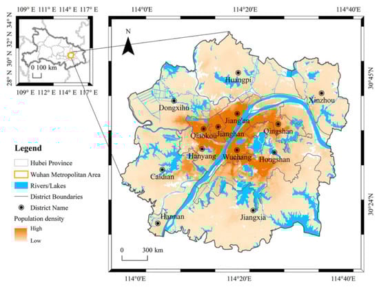
Figure 1.
Research area.
2.2. Data and Processing
2.2.1. Nighttime Light Data Sources
- (1)
- SNPP–VIIRS Monthly Composite Data
Offering 700 m spatial resolution and reduced saturation, this dataset is well-suited for intra-urban analysis and the delineation of urban edges [6].
- (2)
- Luojia-1 Data
A Chinese NTL sensor providing high spatial detail (130 m), enabling fine-scale urban mapping with strong regional adaptability [7].
- (3)
- DMSP/OLS Data
A long time-series (1992–2012) dataset with 2.7 km resolution, primarily used for assessing historical urban expansion trends [5] (Table 1).

Table 1.
Data sources.
2.2.2. Urban Built-Up Area Extraction Methods
To assess the accuracy, scalability, and robustness of various classification approaches, we implemented three representative methods under a unified preprocessing-and-evaluation pipeline.
- (1)
- Thresholding Method
This method applies a fixed or adaptive threshold to the radiance values (DN) of nighttime light data to distinguish built-up from non-built-up pixels. When data calibration is consistent, thresholding offers fast and effective results [13,14]. However, performance deteriorates under inter-sensor or interannual radiometric variability. The binary classification formula is expressed as:
where is the output mask and is the empirically/statistically determined threshold. In this study, the threshold was determined using Otsu’s method applied to Luojia-1 imagery histograms, resulting in an optimal threshold of = 43.5 (DN units).
- (2)
- Multi-Temporal Image Fusion Method
This method integrates multiple temporal NTL acquisitions to suppress short-term variability and improve boundary-delineation stability. Temporal composites are generated via mean or median radiance, followed by unsupervised classification (e.g., K-means). It is particularly effective for identifying stable urban cores while filtering transient light sources [8,15,16]. The fused radiance is calculated as:
where is the number of time periods. In this study, the number of clusters was set to , aiming to differentiate built-up and non-built-up classes. K-means clustering used 10 random restarts with a maximum of 100 iterations to promote convergence stability.
- (3)
- Support Vector Machine (SVM) Method
This supervised learning approach classifies each pixel based on a hybrid feature vector incorporating radiance, texture (e.g., GLCM contrast), and temporal metrics (e.g., stability index) [9,17]. The model is trained using high-confidence sample points from Luojia-1 and applied to other datasets. The decision function of the SVM is:
where is the radial basis function kernel. Post-processing with a majority filter is applied to reduce salt-and-pepper noise. In this study, the Radial Basis Function (RBF) kernel was adopted. The SVM hyperparameters were optimized via five-fold cross-validation, and the final settings were as follows: C = 10, gamma = 0.01. Post-processing using majority filtering was applied to remove salt-and-pepper noise (Table 2).
Table 2.
Summary of methodological trade-offs.
2.2.3. Cross-Dataset Evaluation Protocol
To ensure methodological robustness and facilitate fair comparisons across heterogeneous NTL datasets, we propose a standardized cross-dataset evaluation protocol. This protocol includes three key metrics designed to assess spatial, temporal, and computational consistency: (1) Consistency Index (CI): Quantifies the spatial agreement of built-up area extraction results across datasets (e.g., SNPP/VIIRS vs. DMSP/OLS). CI is computed based on the Intersection-over-Union (IoU) metric between binary extraction masks. Higher CI values indicate greater spatial robustness and cross-sensor compatibility; (2) Stability Score (SS): Evaluates the temporal consistency of built-up delineations across seasonal variability. This score is calculated as the inverse of the standard deviation of built-up area extent across monthly composites. A higher SS reflects greater temporal stability; (3) Processing Efficiency: Measures the computational efficiency and scalability of each method by recording execution time on standardized 10-million-pixel scenes. This benchmark is used to compare the operational efficiency of thresholding and SVM implementations, particularly under high-resolution constraints [18].
Together, these indicators complement traditional accuracy metrics (e.g., kappa, F1-score) and offer a multi-dimensional framework for evaluating methodological performance across diverse nighttime light datasets (Table 3).
Table 3.
Indicators used in the cross-dataset evaluation protocol.
2.3. Methodological Framework Overview
To systematically investigate the delineation and consistency evaluation of urban built-up areas using multi-source Nighttime Light Remote Sensing (NTL) data, a comprehensive research framework was established (Figure 2). The framework comprises four core modules: (1) theoretical foundations, (2) data acquisition and preprocessing, (3) methodological implementation, and (4) evaluation and optimization.
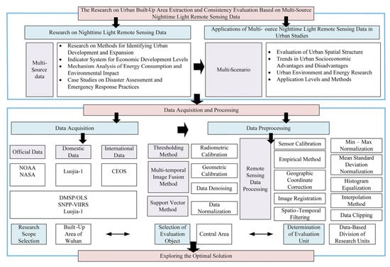
Figure 2.
Research framework.
The above section outlines the dual research basis of the study. On one side, it builds upon foundational studies on nighttime light remote sensing, including urban expansion detection, energy consumption analysis, disaster assessment, and environmental assessment. On the other side, it explores the practical application of multi-source NTL data in urban studies, such as socioeconomic pattern recognition, spatial structure evaluation, and urban energy dynamics.
The data acquisition and preprocessing module integrates various NTL data sources, including official datasets (e.g., NOAA, NASA), domestic datasets (e.g., Luojia-1), and international sources (e.g., CEOS). Three key NTL satellite products—DMSP/OLS, SNPP/VIIRS, and Luojia-1—are utilized to represent different spatial and radiometric characteristics. The study area is the built-up area of Wuhan and the research focuses on the central urban region using representative evaluation units.
Data preprocessing involves a multi-stage procedure, including radiometric calibration, geometric correction, and denoising. These steps are followed by intensity normalization, employing methods such as min–max scaling, z-score standardization, and histogram equalization. In parallel, spatial–temporal processing is conducted, involving image registration, coordinate correction, and spatial filtering to enhance data consistency across time and space. The processed data are then clipped and partitioned into analysis units using empirical rules and spatial interpolation. Three extraction approaches are implemented: thresholding, support vector machine (SVM), and multi-temporal image fusion, each applied across datasets. These methods are selected to reflect both traditional and machine learning paradigms in urban extent delineation.
Finally, the evaluation module encompasses consistency assessment through inter-method comparison and cross-dataset analysis. Evaluation units and the central urban area are defined to ensure comparability. The framework culminates in a comprehensive evaluation of performance and suitability, aiming to identify the most appropriate combination of dataset and method for built-up area delineation.
3. Results
3.1. Comparison of Extraction Accuracy Across Methods and Datasets
To quantitatively assess the performance of different urban built-up area extraction approaches based on multi-source nighttime light (NTL) data, kappa coefficients were computed for three methods (thresholding, SVM, and multi-temporal image fusion) across three datasets (SNPP/VIIRS, DMSP/OLS, and Luojia-1). The results are illustrated in Figure 3.
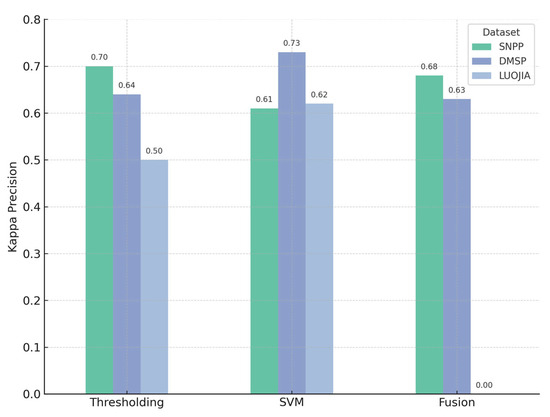
Figure 3.
Performance comparison across different datasets and methods.
Among all combinations, the SNPP/VIIRS dataset generally achieved high accuracy [19,20], especially with the thresholding method (kappa = 0.70) and fusion method (kappa = 0.68). The DMSP/OLS dataset performed best with the SVM method (kappa = 0.73), outperforming SNPP and Luojia-1 under the same method.
In contrast, the Luojia-1 dataset exhibited relatively poor delineation accuracy. The kappa coefficient for thresholding was 0.50, and for multi-temporal image fusion, it was reported as 0.00. This value does not reflect algorithmic failure; it reflects insufficient multi-temporal Luojia-1 coverage, which precluded running the fusion procedure (i.e., not applicable). This analysis highlights the critical role of both data availability and temporal consistency in ensuring effective fusion-based delineation. The results confirm that SNPP/VIIRS and DMSP/OLS datasets provide more stable and reliable support for urban built-up area delineation, particularly when paired with robust methods such as thresholding and SVM.
3.2. Purpose and Scope of Data Source Applicability Analysis
To supplement the quantitative assessment of delineation accuracy presented in Section 3.1 and to provide a more intuitive understanding of spatial performance, this section conducts a visual assessment of the applicability of different nighttime lights (NTL) datasets across multiple delineation methods. Specifically, it investigates how spatial resolution, radiometric quality, and data characteristics influence the delineation of urban built-up areas. By comparing the spatial outputs side-by-side, this section links the numerical evaluation and the subsequent consistency analysis in Section 3.3, thereby strengthening the overall coherence of the results chapter.
Figure 4 presents the spatial delineation results generated using three methods—thresholding, multi-temporal image fusion, and support vector machine (SVM)—applied to three NTL datasets: DMSP/OLS, SNPP/VIIRS, and Luojia-1.
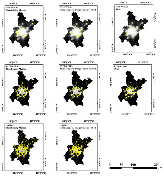
Figure 4.
Comprehensive performance evaluation.
The DMSP/OLS-based results (top row) exhibit relatively coarse spatial resolution, with significant light blooming effects observed around urban centers [6]. The thresholding and SVM outputs show smoother and more generalized urban boundaries, while the multi-temporal image fusion yields in a fragmented and blurred built-up pattern, likely due to radiometric saturation and temporal misalignment.
The SNPP/VIIRS-based outputs (middle row) demonstrate finer spatial detail and sharper urban-edge delineation. Thresholding and multi-temporal image fusion generate compact and centralized urban forms, consistent with known built-up regions. The SVM output moderately overestimates peripheral development, potentially due to the influence of ambient lighting and surrounding semi-urban features.
The Luojia-1-based visualizations (bottom row) showcase the highest spatial resolution [21], capturing intricate urban morphology. However, the thresholding method introduces noticeable noise in non-urban areas, while the multi-temporal image fusion can overestimate built-up extent owing to brightness accumulation from temporal compositing. Because of data limitations, SVM results for Luojia-1 were unavailable, precluding a complete method-wise comparison. In summary, the spatial visualizations corroborate the quantitative findings from Section 3.1: SNPP/VIIRS achieves a balance between spatial clarity and delineation completeness, DMSP/OLS is affected by saturation and coarse resolution, and Luojia-1, while spatially rich, may lead to overestimation and noise interference. These visual insights provide a necessary and complementary qualitative context for the consistency evaluation in the next section.
3.3. Consistency Evaluation Conclusion
To assess the spatial agreement of urban built-up area delineation results across different methods and nighttime lights (NTL) datasets, we conducted a consistency analysis using overlay-based spatial overlap metrics. Specifically, we calculated the intersection over union (IoU) between binary delineation masks from various method–dataset pairs [22]. This metric measures the proportion of spatial overlap relative to the union of built-up regions, thereby quantifying spatial agreement. The IoU analysis revealed that the following facts: (1) The highest spatial consistency was observed between SNPP/VIIRS-thresholding and SNPP/VIIRS-fusion, with an average IoU of 0.76, indicating high internal agreement within the same dataset. (2) Cross-dataset comparison (e.g., SNPP vs. DMSP, SNPP vs. Luojia-1) showed moderate consistency, with IoU values ranging from 0.52 to 0.64, depending on the method used. This suggests that dataset characteristics (e.g., radiometric sensitivity/dynamic range and spatial resolution) substantially influence delineation similarity. (3) The lowest agreement was observed between Luojia-1-fusion and other methods/datasets (average IoU < 0.40), likely due to the brightness accumulation, noise amplification, and overestimation introduced by temporal compositing of Luojia-1 imagery (Figure 5).
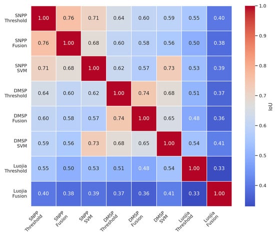
Figure 5.
IoU consistency matrix across methods and datasets.
These findings imply that method–dataset consistency is strongest when both temporal sampling and spatial resolution are stable (e.g., SNPP/VIIRS), and weakest when data variability or noise is high (e.g., Luojia-1-fusion). Moreover, methods such as SVM, which rely heavily on training samples, may introduce additional inconsistency when transferred across datasets with differing sensor characteristics [23].
Therefore, for applications requiring high inter-method consistency—such as long-term urban growth monitoring or comparative urbanization studies—SNPP/VIIRS combined with thresholding or SVM provides a reliable and reproducible delineation approach.
4. Discussion
4.1. Influence of Dataset Characteristics on Extraction Accuracy
The delineation accuracy of built-up areas is significantly influenced by the spatial resolution, radiometric quality, and temporal coverage of different nighttime light (NTL) datasets [24,25]. The SNPP/VIIRS dataset consistently achieved high kappa coefficients with multiple methods, particularly in the thresholding (0.70) and fusion (0.68) approaches. This superior performance is attributable to its high radiometric sensitivity and daily temporal granularity, which provide stable and continuous representations of urban lighting patterns [26].
In contrast, the DMSP/OLS dataset demonstrated the highest accuracy with the SVM method (kappa = 0.73), despite its coarse spatial resolution (≈1 km). This result may stem from the long-term historical coverage of DMSP/OLS data, which enables the identification of persistent urban lighting patterns over time, thereby enhancing the model’s ability to distinguish built-up areas [27,28]. However, its radiometric saturation and limited radiometric resolution likely limit its effectiveness in thresholding and multi-temporal image fusion approaches [29].
The Luojia-1 dataset, although featuring the highest spatial resolution (~130 m), exhibited the lowest extraction accuracy overall. Notably, the kappa value for the fusion method dropped to zero due to the unavailability of multi-temporal Luojia-1 imagery, which is a prerequisite for temporal fusion algorithms. This indicates that spatial resolution alone does not guarantee better performance in the absence of sufficient temporal information [30,31].
Although the delineation results based on different NTL datasets and methods exhibit consistent trends—particularly the superior performance of SNPP/VIIRS in both accuracy and consistency—the absence of ground-truth data (e.g., official built-up area maps or field survey data) hinders comprehensive validation [32]. Without reliable ground-truth data, the accuracy of the extracted delineated built-up areas can only be indirectly appraised using internal evaluation metrics such as the kappa coefficient and IoU. As a result, while the relative performance among methods and datasets is interpretable, the absolute accuracy remains uncertain, limiting the scope of conclusions that can be drawn from these results.
These findings underscore the importance of selecting appropriate NTL datasets not only on spatial resolution but also on temporal continuity and data richness [33]. Furthermore, the availability of reliable ground-truth references is crucial for robust accuracy validation and benchmarking across delineation approaches.
4.2. Methodological Comparison
The visual comparison of spatial delineation outputs further confirms the patterns observed in the quantitative accuracy metrics. Each of the three methods—thresholding, multi-temporal image fusion, and SVM—exhibits distinct strengths and weaknesses when applied across the three NTL datasets [34,35]. Thresholding offers computational simplicity and the stable delineation of central urban cores but is sensitive to background noise, especially in high-resolution data such as Luojia-1 [36]. The fusion method captures temporal trends and enhances continuity in urban form recognition but suffers from brightness accumulation and artifacts in datasets with limited or inconsistent temporal coverage. SVM generally performs well in capturing spatial variability and suburban expansion, particularly with DMSP/OLS, yet can overestimate urban boundaries in contexts with radiometrically noisy contexts such as SNPP/VIIRS [37,38].
Importantly, while the study evaluates these three commonly used methods independently, it does not explore hybrid frameworks that may integrate their respective advantages. For example, threshold-based masking followed by SVM classification could improve both accuracy and noise reduction, particularly for complex urban-peri-urban transitions [39]. The current experimental design also lacks -fold cross-validation or spatial hold-out validation, which are crucial for assessing the generalizability of machine learning models across different urban subregions [40].
To partially address this limitation, Section 3.3 introduces the use of intersection over union (IoU) as an internal consistency metric, providing an additional layer of robustness assessment. However, IoU analysis alone cannot substitute for the absence of rigorous external validation or ensemble-based approaches [41]. Future work should consider incorporating cross-method pipelines and validation strategies to improve delineation reliability and transferability (Table 4).
Table 4.
Urban built-up area extraction method comparison.
4.3. Evaluation of Inter-Method Agreement and Future Advancements
The spatial consistency analysis based on intersection over union (IoU) metrics provides critical insights into the robustness and agreement of delineation results across methods and datasets. High IoU scores—particularly between SNPP/VIIRS–thresholding and SNPP/VIIRS–fusion (average IoU = 0.76)—highlight that when temporal sampling and radiometric characteristics are stable, within-dataset inter-method agreement is high [42]. Conversely, lower IoU values (<0.40) observed in combinations involving Luojia-1 multi-temporal image fusion suggest that brightness accumulation, compositing artifacts, and temporal inconsistencies undermine spatial agreement [43]. These findings indicate that both data quality and methodological design jointly determine the reliability of urban built-up area delineation.
Moreover, the variability in inter-method consistency is more pronounced in machine learning-based approaches like SVM, especially when applied to datasets with differing radiometric characteristics and spatial resolutions [44]. This suggests that classifier-based methods may struggle to generalize across heterogeneous sensor inputs, thereby reducing the comparability of results in multi-source contexts.
The selection of traditional approaches (thresholding, multi-temporal image fusion, and SVM) in this study ensures interpretability and backward compatibility, particularly for legacy datasets like DMSP/OLS. However, recent advances in deep learning—especially convolutional neural networks (CNNs) such as U-Net—have demonstrated superior segmentation capabilities in remote sensing applications [45,46,47]. These models offer improved edge detection, better adaptation to urban form heterogeneity, and the ability to learn spatial hierarchies from labeled data [48].
Future research should benchmark CNN-based models (e.g., U-Net, DeepLabV3+) or Transformer-based architectures (e.g., TransUNet) against traditional methods, not only in terms of pixel-wise accuracy but also in terms of spatial consistency and generalization across cities [49,50]. In addition, integrating NTL with complementary data sources—such as daytime multispectral imagery, high-resolution land cover maps, and socioeconomic indicators—may further enhance both the semantic richness and precision of urban delineation outcomes [51,52,53]. Such data fusion strategies could be especially valuable for fine-scale planning, urban growth forecasting, and cross-city comparative studies [54,55].
5. Conclusions
This study systematically compared three urban built-up area delineation methods—thresholding, multi-temporal image fusion, and support vector machine (SVM)—across three major nighttime lights (NTL) datasets—DMSP/OLS, SNPP/VIIRS, and Luojia-1—using Wuhan as a representative case study. Results show that SNPP/VIIRS combined with thresholding or SVM yielded the most reliable delineation outcomes, achieving both high accuracy and inter-method consistency. In contrast, Luojia-1 performance was constrained by the lack of temporal coverage, and the DMSP/OLS dataset exhibited strong historical stability but was affected by radiometric saturation.
The findings emphasize that no single method–dataset combination universally outperforms others; instead, delineation reliability is jointly shaped by sensor characteristics (e.g., spatial resolution, temporal sampling, radiometric sensitivity/dynamic range) and methodological design. Particularly, consistent results are more likely when data sources offer stable temporal coverage and sufficient radiometric sensitivity.
Nevertheless, several limitations remain. First, the absence of authoritative ground-truth data constrained validation to internal metrics such as the kappa coefficient and intersection over union (IoU), which may not fully capture map accuracy. Second, the study did not implement hybrid frameworks or deep learning models such as U-Net, which may outperform traditional classifiers in complex urban settings. Third, the lack of -fold cross-validation may limit the assessed generalizability of SVM across heterogeneous urban forms. Additionally, the geographical generalizability is limited. Because the analysis focuses solely on Wuhan, the findings may not directly apply to cities with different urbanization stages, topographies, or data accessibility. We recommend that future research examine typical city types—especially those sharing similar characteristics with Wuhan, such as fast-growing plain-terrain cities with available Luojia-1 coverage—to improve the transferability and applicability of delineation strategies. Future work should incorporate authoritative ground-reference datasets, adopt hybrid frameworks that combine traditional techniques with deep learning-based delineation approaches, and integrate additional geospatial features (e.g., multispectral imagery, socioeconomic indicators) to enhance robustness and scalability. Building on the current comparative evaluation of thresholding, multi-temporal image fusion, and SVM—which provides valuable guidance for method selection—future studies should explore advanced architectures (e.g., CNNs, Transformers) while also deepening investigations into foundational methods. For example, assessing how thresholding performance varies under different atmospheric conditions and across seasons could refine applicability in diverse contexts. Evaluating model performance across varied urban environments will be critical for developing adaptive and transferable urban monitoring frameworks.
Author Contributions
S.T.: Conceptualization; Data Processing; Formal Analysis; Investigation; Methodology Validation; Visualization; Writing—original draft; and Writing—review and editing. Q.Z.: Conceptualization; Funding Acquisition; Supervision, Writing—review and editing. R.Q.: Formal Analysis, Investigation, Software, Visualization. J.Y.: Data Processing, Formal Analysis, Software. A.Q.: Data Processing, Formal Analysis, Visualization, Software. All authors have read and agreed to the published version of the manuscript.
Funding
This research is funded by the National Natural Science Foundation of China (No. 52078389).
Institutional Review Board Statement
This study does not involve human participants or animal subjects. Therefore, ethical approval was not required.
Data Availability Statement
The data are open source.
Acknowledgments
The authors also thank the editor and the four anonymous reviewers for their insightful comments that have been very helpful in improving this paper.
Conflicts of Interest
The authors declare no conflicts of interest.
References
- Zhou, Y.; Smith, S.J.; Zhao, K.; Imhoff, M.L.; Thomson, A.M.; Bond-Lamberty, B.; Asrar, G.R.; Zhang, X.; He, C.; Elvidge, C.D. A global map of urban extent from nightlights. Environ. Res. Lett. 2014, 9, 054009. [Google Scholar] [CrossRef]
- Xiao, Y.; Wang, Q.; Zhou, D. Exploring the spatial heterogeneity of urban land expansion and its driving forces in China using geographically weighted regression. Appl. Geogr. 2018, 94, 89–98. [Google Scholar]
- Chen, Y.; Zheng, Z.; Wu, Z.; Qian, Q. Review and prospect of nighttime light remote sensing data applications. Prog. Geogr. 2019, 38, 205–223. [Google Scholar]
- Ye, X.; Liu, X.; Li, X. Spatiotemporal patterns of global urbanization and its relationship with economic development using nighttime light data. Sustainability 2021, 13, 8609. [Google Scholar]
- Huang, X.; Shi, K.; Cui, Y.; Li, Y. A saturated light correction method for DMSP-OLS nighttime stable light data. IEEE JSTARS 2021, 14, 1885–1894. [Google Scholar]
- Chen, Z.; Yu, B.; Yang, C.; Zhou, Y.; Yao, S.; Qian, X.; Wang, C.; Wu, B.; Wu, J. An extended time series (2000–2018) of global NPP-VIIRS-like nighttime light data. Earth Syst. Sci. Data 2021, 13, 889–906. [Google Scholar] [CrossRef]
- Zhong, L.; Liu, X. Application potential analysis of new-type nighttime light data from Luojia-1. Bull. Surv. Mapp. 2019, 7, 132–137. [Google Scholar]
- Hong, Y.; Wu, B.; Song, Z.; Li, Y.; Wu, Q.; Chen, Z.; Liu, S.; Yang, C.; Wu, J.; Yu, B. A monthly night-time light composite dataset of NOAA-20 in China: A multi-scale comparison with S-NPP. Int. J. Remote Sens. 2021, 42, 7931–7951. [Google Scholar] [CrossRef]
- Mantero, P.; Moser, G.; Serpico, S.B. A simple and effective method for the classification of remote sensing images using SVM. IEEE Trans. Geosci. Remote Sens. 2005, 43, 598–608. [Google Scholar]
- Liu, Q.; Zhan, Q.; Li, J.; Yang, C.; Liu, W. Application of Luojia-1 nighttime light images in built-up land extraction: A case study of Wuhan. Geomat. Inf. Sci. Wuhan Univ. 2021, 46, 30–39. [Google Scholar]
- Turen, Y.; Sanli, D.U. Accuracy of Deformation Rates from Campaign GPS Surveys Considering Extended Observation Session and Antenna Set-Up Errors. Remote Sens. 2019, 11, 1225. [Google Scholar] [CrossRef]
- Huang, X.; Wang, Y. Investigating the effects of 3D urban morphology on the surface urban heat island effect in urban functional zones by using high-resolution remote sensing data: A case study of Wuhan, Central China. ISPRS J. Photogramm. Remote Sens. 2019, 152, 119–131. [Google Scholar] [CrossRef]
- Zhang, Q.; Schaaf, C.; Seto, K.C. The vegetation adjusted NTL urban index: A new approach to reduce saturation and increase variation in nighttime luminosity. Remote Sens. Environ. 2013, 129, 32–41. [Google Scholar] [CrossRef]
- Wu, Z.; Liu, X.; Zhan, Q. An object-based method for detecting urban expansion using nighttime light data. Remote Sens. Lett. 2022, 13, 141–149. [Google Scholar]
- Ma, T. An Estimate of the Pixel Level Connection between Visible Infrared Imaging Radiometer Suite Day/Night Band (VIIRS DNB) Nighttime Lights and Land Features across China. Remote Sens. 2018, 10, 723. [Google Scholar] [CrossRef]
- Lu, H.; Zhang, M.; Sun, W.; Li, W. Expansion Analysis of Yangtze River Delta Urban Agglomeration Using DMSP/OLS Nighttime Light Imagery for 1993 to 2012. ISPRS Int. J. Geo-Inf. 2018, 7, 52. [Google Scholar] [CrossRef]
- Feng, X.; Shao, Z.; Huang, X.; He, L.; Lv, X.; Zhuang, Q. Integrating Zhuhai-1 hyperspectral imagery with Sentinel-2 multispectral imagery to improve high-resolution impervious surface area mapping. IEEE J. Sel. Top. Appl. Earth Obs. Remote Sens. 2022, 15, 2410–2424. [Google Scholar] [CrossRef]
- Liu, Z.; He, C.; Zhou, Y.; Wu, J. How much of the world’s land has been urbanized, really? A hierarchical framework for avoiding confusion. Landsc. Ecol. 2020, 35, 1911–1925. [Google Scholar] [CrossRef]
- Shi, K.; Yu, B.; Huang, C.; Hu, Y.; Yin, B.; Chen, Z.; Wu, J. Evaluating the ability of NPP–VIIRS nighttime light data to extract built-up urban areas: A comparison with DMSP–OLS data. Remote Sens. Lett. 2014, 5, 358–366. [Google Scholar] [CrossRef]
- Wang, J.; Li, Y. Evaluating VIIRS nighttime light data for urban spatial analysis. ISPRS Int. J. Geo-Inf. 2021, 10, 280. [Google Scholar]
- Zhai, W.; Han, B.; Cheng, C. Evaluation of Luojia 1-01 Nighttime Light Imagery for Built-Up Urban Area Extraction: A Case Study of 16 Cities in China. IEEE Geosci. Remote Sens. Lett. 2020, 17, 1802–1806. [Google Scholar] [CrossRef]
- Ma, L.; Liu, Y.; Zhang, X.; Ye, Y.; Yin, G.; Johnson, B.A. Deep learning in remote sensing applications: A meta-review. ISPRS J. Photogramm. Remote Sens. 2018, 145, 134–153. [Google Scholar] [CrossRef]
- Goldblatt, R.; Stuhlmacher, M.F.; Tellman, B.; Clinton, N.; Hanson, G.; Georgescu, M.; Wang, C.; Serrano-Candela, F.; Balling, R.C., Jr. Mapping Urban Land Cover: A Novel Machine Learning Approach Using Landsat and Night-time Lights. Remote Sens. Environ. 2018, 217, 221–232. [Google Scholar]
- Elvidge, C.D.; Baugh, K.E.; Zhizhin, M.; Hsu, F.C. Why VIIRS data are superior to DMSP for mapping nighttime lights. Int. J. Remote Sens. 2017, 38, 5860–5879. [Google Scholar] [CrossRef]
- Li, X.; Zhou, Y. Urban mapping using nighttime light data: A review. Remote Sens. Environ. 2021, 256, 112307. [Google Scholar]
- Zhang, Q.; Pandey, B.; Seto, K.C. High-frequency VIIRS nighttime light data reveal dynamic urban expansion. ISPRS J. Photogramm. Remote Sens. 2022, 183, 321–333. [Google Scholar]
- Li, X.; Xu, H.; Chen, X.; Li, C. Potential of NPP-VIIRS nighttime light imagery for modeling the regional economy of China. Remote Sens. 2013, 5, 3057–3081. [Google Scholar] [CrossRef]
- Shao, Z.; Zhang, Y.; Huang, X. Spatiotemporal patterns of urban expansion using DMSP/OLS nighttime light data in China. Cities 2020, 96, 102415. [Google Scholar]
- Small, C.; Pozzi, F.; Elvidge, C.D. Nighttime satellite imagery: Interpretation and applications for socioeconomic studies. Remote Sens. Environ. 2021, 247, 111872. [Google Scholar]
- Yang, L.; Yang, Y.; Shen, H. Comparative evaluation of Luojia-1 and VIIRS NTL data for urban analysis. Remote Sens. Environ. 2023, 284, 113330. [Google Scholar]
- Chen, Z.; Yin, H.; Fang, S. Assessing the performance of high-resolution Luojia-1 imagery in urban studies. Int. J. Remote Sens. 2022, 43, 3224–3240. [Google Scholar]
- Zhao, N.; Cao, G.; Samson, E.L.; Wang, J. Challenges in validating NTL-based urban extent maps due to limited ground truth data. Urban Stud. 2020, 57, 498–517. [Google Scholar]
- Huang, Q.; Lu, Y. A framework for selecting appropriate NTL data for urban studies. Remote Sens. Lett. 2019, 10, 875–884. [Google Scholar]
- Ma, T.; Zhou, Y.; Pei, T. Comparison of threshold and SVM for nighttime light-based urban classification. Sensors 2018, 18, 1138. [Google Scholar]
- Shi, K.; Chen, Y.; Yu, B.; Xu, T.; Chen, Z.; Wu, J. Multi-temporal image fusion for improving nighttime light-based urban area extraction. Remote Sens. 2020, 12, 2125. [Google Scholar]
- Levin, N.; Zhang, Q. A global analysis of threshold-based urban boundary detection using nighttime light data. ISPRS J. Photogramm. Remote Sens. 2020, 167, 86–99. [Google Scholar]
- Zhang, J.; Li, Z.; Ma, L. Nighttime light fusion and temporal stability for improved urban monitoring. IEEE J. Sel. Top. Appl. Earth Obs. Remote Sens. 2022, 15, 2111–2123. [Google Scholar]
- Yao, X.; Sun, X.; Liu, H. Overestimation of urban extents in SVM-based classification of NTL data. Comput. Environ. Urban Syst. 2021, 85, 101543. [Google Scholar]
- Wang, W.; Gong, J.; Lin, L. Hybrid approaches to enhance nighttime urban detection. Int. J. Appl. Earth Obs. Geoinf. 2020, 90, 102123. [Google Scholar]
- Ghamisi, P.; Plaza, J.; Benediktsson, J.A. Validation protocols for classification algorithms in remote sensing. IEEE Geosci. Remote Sens. Mag. 2019, 7, 54–65. [Google Scholar]
- Bai, Y.; Zhou, Y.; Chen, H. Evaluating spatial agreement using IoU for urban area extraction. J. Urban Technol. 2023, 30, 54–71. [Google Scholar]
- Zhang, Q.; Pandey, B. The influence of radiometric resolution on method agreement in urban extraction. Remote Sens. Environ. 2020, 248, 111983. [Google Scholar]
- Wu, W.; Xu, H.; Zhang, X. Artifact-induced spatial inconsistencies in Luojia-1 temporal fusion. ISPRS J. Photogramm. Remote Sens. 2021, 175, 92–105. [Google Scholar]
- Xie, Y.; Fang, S.; Yin, H. Sensitivity of machine learning methods to radiometric heterogeneity in NTL data. Remote Sens. 2022, 14, 2135. [Google Scholar]
- Ronneberger, O.; Fischer, P.; Brox, T. U-Net: Convolutional Networks for Biomedical Image Segmentation. In Medical Image Computing and Computer-Assisted Intervention–MICCAI 2015; Navab, N., Hornegger, J., Wells, W.M., Frangi, A.F., Eds.; Springer: Cham, Switzerland, 2015; pp. 234–241. [Google Scholar]
- Zhang, Y.; Wang, J.; Wu, J. Urban feature extraction using U-Net from high-resolution remote sensing imagery. Remote Sens. 2021, 13, 712. [Google Scholar]
- Xie, H.; Liu, Y.; Gao, B. Comparative study of CNN-based and traditional classification for urban land use. ISPRS J. Photogramm. Remote Sens. 2022, 187, 235–248. [Google Scholar]
- Bischke, B.; Helber, P.; Borth, D. Deep learning for pixel-level mapping in urban environments. IEEE Geosci. Remote Sens. Lett. 2019, 16, 1128–1132. [Google Scholar]
- Liu, J.; Wang, S.; Hu, M. DeepLabV3+ for accurate urban boundary extraction from remote sensing data. Remote Sens. Environ. 2023, 290, 113378. [Google Scholar]
- Chen, L.C.; Zhu, Y.; Papandreou, G.; Schroff, F.; Adam, H. Encoder-Decoder with Atrous Separable Convolution for Semantic Image Segmentation. In Computer Vision–ECCV 2018; Ferrari, V., Hebert, M., Sminchisescu, C., Weiss, Y., Eds.; Springer: Cham, Switzerland, 2018; pp. 801–818. [Google Scholar]
- Hu, X.; Xu, H.; Fang, S. Fusion of nighttime light and multispectral data for refined urban area extraction. Int. J. Remote Sens. 2021, 42, 5004–5021. [Google Scholar]
- Zhang, H.; Li, X.; Wang, L. Integrating socioeconomic data into NTL-based urban delineation. Comput. Environ. Urban Syst. 2020, 80, 101452. [Google Scholar]
- Yu, B.; Liu, H.; Wu, J.; Zhang, L. Urban form recognition from fused optical and nighttime light data. IEEE J. Sel. Top. Appl. Earth Obs. Remote Sens. 2019, 12, 2135–2147. [Google Scholar]
- Tang, J.; Zhang, Y.; Yang, X. High-resolution monitoring of urban microstructures using fused remote sensing data. Remote Sens. Environ. 2022, 281, 113197. [Google Scholar]
- Gong, P.; Li, X.; Wang, J.; Zhang, C. Annual maps of global artificial impervious area (GAIA) from 1985 to 2018. Nat. Sustain. 2020, 3, 529–540. [Google Scholar]


Disclaimer/Publisher’s Note: The statements, opinions and data contained in all publications are solely those of the individual author(s) and contributor(s) and not of MDPI and/or the editor(s). MDPI and/or the editor(s) disclaim responsibility for any injury to people or property resulting from any ideas, methods, instructions or products referred to in the content. |
© 2025 by the authors. Licensee MDPI, Basel, Switzerland. This article is an open access article distributed under the terms and conditions of the Creative Commons Attribution (CC BY) license (https://creativecommons.org/licenses/by/4.0/).