


Highlights
What are the main findings?
- GS-TreeAttn significantly improves tree point cloud completion under occlusion and non-uniform sampling conditions.
- The structure-guided density-adaptive attention mechanism effectively captures both global topology and local geometric details.
What are the implications of the main findings?
- Enhanced point cloud reconstruction supports more accurate tree structural parameter estimation, including height and canopy structure.
- The method is robust for real-world urban forestry and LiDAR applications, improving downstream ecological and inventory analyses.
Abstract
Accurate reconstruction of complete tree point clouds is essential for estimating ecosystem structural characteristics from LiDAR data. In urban forestry environments, however, terrestrial laser scanning (TLS) and mobile laser scanning (MLS) frequently produce incomplete observations. Occlusion caused by neighboring trees, together with interference from surrounding urban objects such as buildings and vehicles, often leads to missing regions within scanned point clouds. These defects may further affect the reliability of tree structural analysis and parameter estimation. Although recent learning-based point cloud completion methods have improved reconstruction performance, several limitations remain when they are applied to complex tree structures. Many existing networks depend on farthest point sampling (FPS) for feature extraction, which can result in the loss of fine-scale branching information. Furthermore, local feature aggregation methods based on the traditional k-nearest neighbor (KNN) strategy are highly sensitive to regions with uneven point cloud distribution, such as the canopy region where density variations are significant in tree point clouds. To alleviate these issues, this study proposes GS-TreeAttn, an attention-guided framework specifically for tree point cloud completion. This network models density and structural representation as a coupled problem and employs a structure-guided density-adaptive attention mechanism to jointly capture global structural dependencies and local geometric features. We comprehensively evaluate the proposed method using publicly available datasets and urban forestry data collected under real-world scanning conditions. Experimental results show that even in complex scenarios with severe occlusion and uneven sampling density, GS-TreeAttn generates more complete reconstruction results. This improvement is particularly evident in regions where the canopy and branches mutually occlude each other, where information loss is very common in real-world urban forestry.
1. Introduction
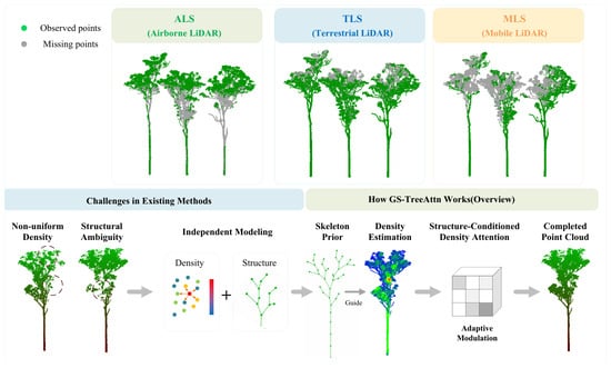
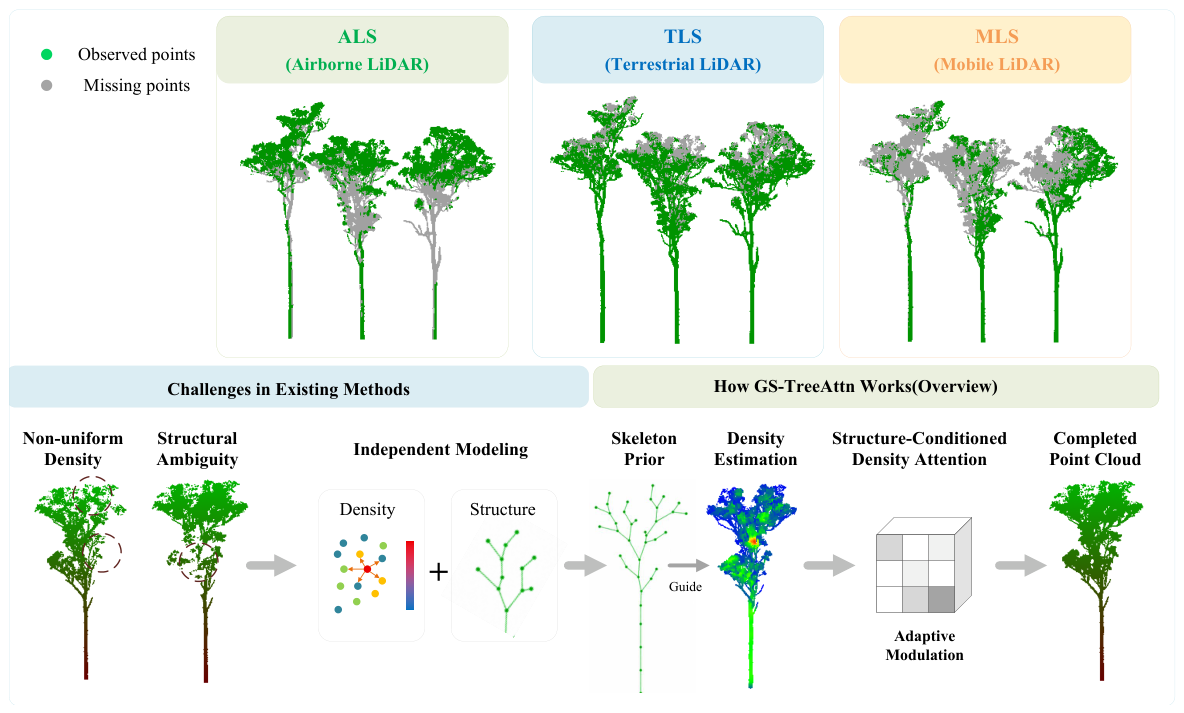
Forests are a vital component of terrestrial ecosystems, and accurate characterization of individual tree structures is crucial for ecological assessment and urban forest management [1]. Structural parameters such as diameter at breast height (DBH), tree height, and biomass are widely used to assess forest condition and ecosystem function [2]. LiDAR has been widely used to acquire these parameters because it provides a detailed three-dimensional characterization of tree morphology [3,4]. Depending on the acquisition platform, including terrestrial laser scanning (TLS), mobile laser scanning (MLS), and airborne laser scanning (ALS), the generated point clouds often contain incomplete areas due to occlusion, limited viewing angles, and platform-specific scanning limitations as shown in Figure 1 [5,6]. As illustrated in the upper part of Figure 1, the missing regions exhibit distinct patterns across different acquisition platforms. For ALS, the missing points are mainly concentrated in the lower part of the tree, particularly around the trunk, due to the top-down observation geometry. In contrast, TLS primarily suffers from missing points in the canopy caused by occlusions from lower branches and foliage. MLS tends to exhibit missing regions on the side of the tree farther from the sensor trajectory, where the laser beams are more susceptible to occlusion and limited visibility. This systematic data gap often leads to biased or unreliable estimations of tree structural attributes. Therefore, reconstructing complete tree point clouds from incomplete observation data has become a key challenge in the field of remote sensing.
Figure 1.
The figure illustrates the scanning results of TLS, ALS, and MLS. The general workflow of point cloud completion is also depicted at the bottom.
To better understand the causes of such incompleteness, we analyze LiDAR point clouds from both occlusion patterns and sampling characteristics. Specifically, in ALS data, occlusion mainly results from the tree canopy blocking the lower parts of the tree, often leading to missing trunk information [7,8]. In contrast, for TLS and MLS scanning methods, occlusion primarily comes from nearby trees and surrounding urban objects such as buildings and vehicles, which obscure parts of the tree structure [9,10]. Besides the aforementioned issues, the point clouds acquired by these scanning platforms typically exhibit a non-uniform density distribution, specifically, points closer to the sensor tend to be denser, while points farther from the sensor are significantly sparser [11,12]. This density heterogeneity further affects the accurate assessment of tree structural features [13].
In summary, tree point clouds face unique challenges compared to general 3D objects due to their complex branch structures and highly irregular point distribution. These features are particularly evident in LiDAR-based acquisitions, where uneven sampling and occlusion frequently occur due to sensor viewpoint and canopy structure [11]. The structural topology and point density of tree point clouds are closely related. In practical LiDAR scanning, sparse regions are often accompanied by broken branch structures, while dense canopy regions may lead to blurred neighborhood features during aggregation [14]. This coupling between geometry and density indicates that treating these two factors separately is insufficient for reliably completing tree point clouds [15].
Currently, point cloud completion methods mainly include point-based methods, voxel-based methods, and Transformer-based methods. Point-based networks, such as PCN [16], TopNet [17], MSN, and FoldingNet, all utilize global feature representations to reconstruct missing regions [2]. While these methods can effectively recover coarse shapes, they often lose fine tree structure and local geometric information in the field of complex tree completion. Voxel-based methods, such as GRNet [18] and VRCNet [19], improve structural continuity by converting irregular point clouds into regular meshes. However, voxelizing point clouds usually reduces geometric accuracy and increases computational cost, especially for dense tree-like point clouds with complex branching patterns [5,6]. In recent years, attention-based models have attracted increasing attention in the field of point cloud completion. Methods such as PoinTr [15], AdaPoinTr [20], SeedFormer [21], and SnowflakeNet [22] enhance feature representation by capturing long-range geometric relationships [3,4,23,24]. However, these frameworks are primarily designed for objects with relatively regular shapes and typically assume a relatively uniform point cloud distribution [5]. This assumption often contradicts real-world tree scan data collected in urban environments.
Recent studies have incorporated tree-related prior information into point cloud completion tasks. For example, TC-Net uses density-aware feature extraction to improve robustness under non-uniform sampling [25], while SK-TreePCN [26] introduces skeleton constraints to maintain structural stability during completion [13]. While both methods improve reconstruction quality, they primarily focus on geometric topology or point distribution [27,28]. In real-world LiDAR data, missing geometric structures and non-uniform point cloud density often coexist due to factors such as occlusion, sensor distance, and scanning viewpoint [25]. Furthermore, missing branches are usually accompanied by locally sparse and irregular point cloud distributions, making feature aggregation and geometric recovery more difficult [29]. In these cases, traditional sampling and neighborhood operations are not entirely reliable.
Farthest point sampling (FPS) may remove fine branch structures during downsampling, while neighborhood grouping based on irregular point distributions easily leads to local feature instability [5,30]. These problems are particularly pronounced in severely occluded canopy regions.
This paper proposes a GS-TreeAttn framework for tree-like point cloud completion under heterogeneous sampling conditions caused by varying LiDAR acquisition geometries, non-uniform point density, and occlusion-induced irregular point distributions. As illustrated in the lower part of Figure 1, the figure is divided into two sections. The left section (“Challenges in Existing Methods”) summarizes the limitations of existing point cloud completion approaches, which typically treat structural information and point density as independent modeling tasks. Such separate modeling strategies may overlook the intrinsic relationship between tree topology and density variation, making it difficult to effectively reconstruct incomplete tree structures under heterogeneous sampling conditions. The right section (“How GS-TreeAttn Works”) presents the proposed framework, which addresses these challenges by jointly modeling structural topology and density variation through a Structure-Guided Density-Adaptive Attention mechanism. To this end, the proposed GS-TreeAttn framework combines skeleton-guided structural information with density-adaptive feature learning to jointly model tree topology and spatial point distribution, thereby improving the reconstruction consistency and completeness of missing regions. The main contributions of this paper are summarized as follows:
- (1)
- We formulate tree point cloud completion as a structure–density coupled reconstruction problem, providing a new perspective for modeling incomplete LiDAR data.
- (2)
- We propose a unified framework that jointly integrates structural priors and density-adaptive feature learning, and develop a structure-guided density-adaptive attention mechanism to capture both global topology and local geometric details under heterogeneous point distributions.
- (3)
- Extensive experiments on both simulated and real-world datasets demonstrate that the proposed method improves reconstruction quality and benefits tree height estimation from incomplete point clouds.
2. Methods
2.1. Overview
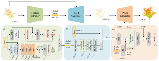
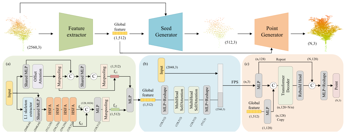
GS-TreeAttn is designed for completing individual tree point clouds from incomplete LiDAR observations. The overall architecture is shown in the Figure 2. This framework integrates structure-aware feature extraction, density-sensitive feature aggregation, and progressive point cloud generation into a unified reconstruction process. Given an incomplete point cloud , the network aims to recover a complete point cloud set while preserving the continuity of branches and geometric details. Compared to common object datasets, tree point clouds contain more irregular branch patterns and stronger density variations. In practical TLS and MLS acquisition processes, occlusion, scan distance, and viewpoint often simultaneously affect structural integrity and local sampling density.
Figure 2.
GS-TreeAttn adopts an encoder–decoder architecture with three main components: (a) feature extractor that learns global features from downsampled and skeleton point clouds, (b) seed generator that enhances geometric representations via adversarial learning and self-attention, and (c) Point Generator that progressively generates the final point cloud. HSFA denotes the Hybrid Structural Feature Attention module. The example outputs N points, while different resolutions can be obtained by adjusting the parameters.
Although FPS and KNN are employed in the proposed framework, they are not used in the same manner as conventional point cloud completion methods. Rather than relying solely on FPS-sampled geometric features, the proposed framework introduces an L1-skeleton branch to provide complementary structural topology information, alleviating the loss of fine branch structures caused by geometric sampling. Similarly, KNN is used only for local density estimation, while feature aggregation is jointly regulated by density descriptors and skeleton-derived structural priors through the proposed Hybrid Structural Feature Attention (HSFA) module. Consequently, the sensitivity of conventional KNN-based feature learning to non-uniform point distributions is significantly reduced.
During preliminary experiments, sparse canopy regions were found to be more prone to broken branches and unstable neighborhood features, whereas densely sampled foliage sometimes produced ambiguous local representations. To account for these characteristics, structural information and point density are modeled jointly during feature learning rather than treated separately. The framework contains three connected components. A dual-branch encoder extracts structural and geometric representations from the input point cloud. The HSFA module then adjusts feature aggregation according to local density variation and structural context. Finally, a progressive decoder reconstructs missing regions from coarse structures to refined geometric details. To better match real scanning conditions, realistic LiDAR missing patterns are simulated during training. The proposed framework is further evaluated using field-collected TLS datasets with complex occlusion and heterogeneous sampling distributions.
2.2. Feature Extractor
Although the point cloud obtained via skeleton-based downsampling preserves most of the local structural information of trees, relying solely on skeletal point clouds as a single-source input may lead the model to overlook important global contextual information. To address this limitation, we propose an improved feature extractor with a dual-branch architecture. Specifically, the proposed feature extractor consists of two complementary branches: the Point Feature Extraction Branch (upper branch) and the Hybrid Feature Extraction Branch (lower branch). The Point Feature Extraction Branch follows a conventional design and takes the downsampled point cloud as input. Its primary objective is to extract both global and local geometric features, which serve as essential geometric constraints for the reconstruction process. By learning these features, the model ensures that the generated point cloud remains within a geometrically plausible space.
In contrast, the Hybrid Feature Extraction Branch takes both the skeletal point cloud and the downsampled point cloud as inputs. This branch is specifically designed to capture structural and semantic information of trees at both global and local scales. The incorporation of skeletal representations enables the network to better preserve the underlying topology and branching patterns, while the inclusion of raw point cloud information supplements missing contextual details.
By jointly leveraging these two branches, the proposed feature extractor effectively balances geometric fidelity and structural awareness. This design allows the model to produce more refined and structurally consistent reconstructions in the subsequent completion stages. This dual-branch design also alleviates the information loss caused by aggressive downsampling and improves the robustness of feature representation under sparse and incomplete conditions.
Point Feature Extraction Branch: The point feature extraction branch of the network adopts a two-stage stacked architecture inspired by the two-stage architecture of PCN, with modifications to incorporate structure-aware features. In the first stage, a multilayer perceptron (Shared MLP) transforms the input point cloud into a feature matrix . This matrix is then processed by an offset-attention module followed by a max-pooling layer to obtain the feature vector . In the second stage, is broadcast to each row of a new feature matrix , which is subsequently fed into another Shared MLP and a max-pooling layer to produce the feature . The concatenation of and yields the feature representation , which effectively captures both global and local characteristics of the point cloud.
Hybrid Feature Extraction Branch: Existing deep-learning–based point cloud completion methods often struggle with structural detail reconstruction in tree point clouds due to density- sensitive KNN-based local partitioning and insufficient modeling of complex tree structures. The hybrid branch is implemented using the proposed HSFA module, which jointly models structural and geometric features,
where denotes the incomplete input point cloud after farthest point sampling (FPS), and represents the skeleton-guided point cloud generated via L1-skeleton-based [31] downsampling. Here, preserves the geometric distribution information of the original point cloud, while provides structural topology priors for subsequent structure-aware feature interaction.
The structure branch encodes skeleton representations derived from the input, which provide a compact description of the underlying tree topology. Let denote geometric features and denote structural features. Instead of treating them independently, we project both features into a shared latent space:
where denotes a feature fusion function. This design allows structural priors to guide feature extraction, especially in sparse regions where geometric information is insufficient. The dual-branch feature extractor enables effective capture of global, local, and structural information from tree point clouds.
2.3. Seed Generator
The Seed Generator reconstructs an initial coarse point cloud from the hybrid feature representation and connects the encoder to the subsequent refinement stage. Its overall design follows the FSC [32] model and introduces improvements to better handle structure and density-related information in tree point clouds. The hybrid features are first fused into a compact latent representation. Before point decoding, these features pass through a refinement network , which consists of an adversarial regularization branch and two self-attention layers. In initial experiments, directly decoding the latent features often produces fragmented branches and unstable local distributions, especially in sparsely sampled canopy regions. Therefore, an adversarial branch is introduced to constrain the generated features, making their distribution closer to that of real tree point clouds. A discriminator is trained to distinguish between the generated representation and the ground truth features, resulting in a more stable coarse reconstruction during optimization. Subsequent self-attention layers further refine feature interactions by fusing contextual information from distant regions. This operation is particularly useful for tree-like structures with long and irregular branches, as local neighborhoods alone are insufficient to describe their geometric continuity. After refinement, the features are mapped to 3D coordinates through a multilayer perceptron (MLP) and several linear layers to generate a coarse point cloud. The generated coarse point cloud preserves the main branch topology and provides stable initialization for the subsequent fine reconstruction stage under non-uniform sampling conditions.
2.4. Point Generator
The Point Generator refines the coarse reconstruction from the previous stage and outputs a completed point cloud with a resolution of , as illustrated in Figure 2c. The coarse point set and global feature representation are jointly used as inputs for dense reconstruction. Point coordinates and feature embeddings are first mapped into a higher-dimensional feature space through several MLP layers. The resulting features are merged point-wise to combine local geometry with global structural information. In early experiments, direct propagation of coarse features often led to branch breaks and unstable density transitions in sparsely sampled regions. To mitigate this, we employ a Transformer decoder to further refine the fused features. This decoder captures dependencies between spatially separated regions and improves structural consistency during reconstruction.
Based on a self-attention mechanism, we progressively increase the point cloud resolution through three cascaded upsampling modules. Each stage upsamples the current point set by a factor of two while refining local feature responses. Unlike uniform feature propagation, the attention mechanism adaptively adjusts feature aggregation based on local point cloud density. This strategy enables smoother transitions between sparse and dense regions and reduces reconstruction artifacts around incomplete canopy structures. After feature refinement, the decoder maps the learned feature representations to 3D coordinates through multiple linear layers to obtain the final complete point cloud. This progressive reconstruction process provides more stable geometric restoration even with irregular sampling and incomplete observations.
2.5. HSFA Module
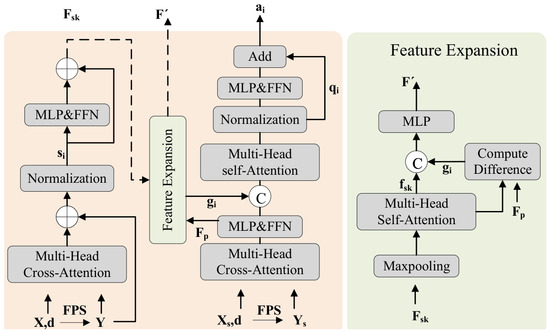
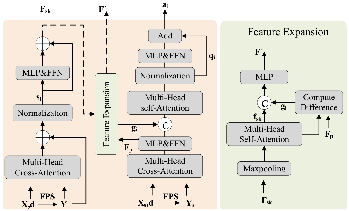
The HSFA module is designed to address the structure–density coupling problem by jointly modeling structural priors and global geometric context for missing region prediction. Its architecture is shown in Figure 3. The module input is represented as , where X denotes the incomplete input point cloud, represents the skeleton-guided point cloud generated using the L1-skeleton extraction algorithm, and both X and have the shape . Here, d denotes the downsampling rate. Since the distribution characteristics of the original point cloud and the skeleton-guided structural point cloud differ significantly, direct feature fusion may lead to unstable feature interactions and inconsistent reconstruction results. Therefore, the HSFA module adopts a dual-branch architecture, where the left branch processes geometric point cloud features and the right branch models skeleton-guided structural features. By applying FPS on X and , two sampled point clouds Y and with the shape are obtained. During each HSFA stage, the module progressively learns the structural discrepancy between the two feature spaces and iteratively embeds topology-aware structural information into the point-wise feature representation through cross-attention and self-attention interactions. Specifically, cross-attention is adopted to enable each structural point to aggregate global contextual information from the full point cloud. We first use the cross-attention mechanism to learn the feature matrix F, which integrates information from all points in X:
Figure 3.
The figure illustrates the Hybrid Structural Feature Attention module.It takes the FPS-downsampled point cloud and the skeleton point cloud as inputs, and learns their differences to predict points in the missing regions.
The implementation of is identical to that in [33]. After the attention operation, each structural point aggregates global contextual features from the full point cloud. To further enhance the representational capacity of the spatial attention block, we apply an MLP with residual connections and a feed-forward network (FFN) to update the feature matrix :
where denotes the concatenation operation. The residual geometric features from X are preserved through skip connections.
We also apply CrossAttention on the point cloud to obtain the feature matrix . To explicitly model the interaction between structure and density, we employ Structure-Guided Density-Adaptive Attention at the feature expansion stage together with a series of linear layers to learn the interaction between the pooled feature vector and the point features , resulting in the feature representation of the missing regions .
where represents the discrepancy between geometric features and structure-guided density-aware features, enabling the model to focus on missing or underrepresented regions. Since both and are generated in the same latent feature space after nonlinear feature embedding, the subtraction operation mainly models relative structural deviations rather than directly operating on raw point representations. This formulation is conceptually similar to residual feature learning and helps enhance discrepancy-aware feature aggregation during feature expansion.
The ComputeDifference module further models this discrepancy to enhance adaptive feature aggregation during feature expansion. Next, a self-attention module is applied to enhance geometric consistency across features, followed by feed-forward refinement.
The outputs of the HSFA module consist of the structure-enhanced point feature and the coupled structure–density feature representation . Specifically, is propagated to the left path of the subsequent HSFA module, while is forwarded to the right path for continued structure–density interaction. Through this dual-path propagation mechanism, stacked HSFA modules progressively embed structural topology information into geometric point features. In the overall network architecture, four consecutive HSFA modules are employed to perform multi-stage structure–density feature interaction. At each stage, skeleton-guided structural information is gradually integrated into the point-wise feature representation, improving topology consistency in incomplete regions. Preliminary experiments and empirical observations indicate that fewer HSFA modules limit hierarchical feature interaction capability, whereas deeper stacking introduces increased computational complexity with only marginal performance gains. Therefore, four HSFA modules were adopted as a trade-off between reconstruction performance and computational efficiency.
Overall, the HSFA module is not a simple feature extraction pipeline, but a structured design that enables the interaction between global context, structural priors, and density-adaptive feature learning.
2.6. Structure-Guided Density-Adaptive Attention
In the feature expansion stage of the HSFA module, where multi-scale features are aggregated and structure–geometry interactions become critical, we design a structure-guided density-adaptive attention mechanism. Unlike conventional attention mechanisms that rely solely on feature similarity, our design explicitly couples structural priors with density-aware modulation, where structural information dynamically governs how point density influences feature aggregation. For each point , a local density descriptor is first estimated based on neighborhood statistics:
where denotes the K-nearest neighbors. This density descriptor captures local sampling characteristics and serves as the basis for adaptive modulation.
To model the interaction between structure and density, we formulate the attention weights as:
where and denote the query and key features, and is a learnable function that performs structure-conditioned density modulation.
Here, provides a structure-dependent scaling factor that modulates the density descriptor , while introduces an additional structure-aware bias term. In contrast to conventional formulations where density and structure are incorporated as independent additive terms, the proposed formulation conditions the density response on structural context through a structure-dependent modulation mechanism. Consequently, the contribution of density information varies according to local structural characteristics rather than acting as a fixed density bias.
Structural features , derived from the skeleton representation, encode topological information such as branch continuity and hierarchical relationships, and act as a guiding signal that regulates density-aware feature aggregation. In this coupled formulation, the attention weights are jointly determined by structural constraints and density variations. In sparse regions, the model prioritizes structural continuity to compensate for missing observations, while in dense regions, it emphasizes local geometric details without over-smoothing.
Without density-aware modulation, feature aggregation becomes unstable under non-uniform sampling, whereas the absence of structural guidance often leads to geometrically plausible but topologically inconsistent reconstructions. By explicitly conditioning density-aware attention on structural priors, the proposed mechanism fundamentally alters the feature aggregation process, enabling joint modeling of structural topology and point distribution. This unified design provides a principled solution to the coupled challenges of occlusion-induced incompleteness and heterogeneous sampling in tree point clouds.
2.7. Loss Function
To effectively address this challenge, the overall objective is designed to jointly enforce geometric accuracy, distribution realism, and structural consistency. Therefore, the loss function is designed to consist of three main components: the completion loss, the adversarial loss and a structure-aware regularization term. The completion loss measures the discrepancy between the completed point cloud and the Ground Truth (G.T.) point cloud, while the adversarial loss encourages the generated features from the adversarial network to approach those of real point clouds. The Chamfer Distance (CD) is employed in the computation of the completion loss, and its formulation is given by:
The completion loss ensures geometric fidelity but is sensitive to non-uniform point distributions, which motivates the introduction of additional constraints. The adversarial loss adopts the standard adversarial objective. Let F denote the generator, whose primary role is to map the input features into a feature space that more closely resembles real features. Let D denote the discriminator, which is trained to distinguish real features from those produced by the generator. The adversarial loss is formulated as:
The adversarial loss serves as an auxiliary constraint to improve the realism of the reconstructed point cloud. The structure-aware loss encourages consistency between reconstructed points and the underlying skeleton representation, promoting topology preservation during completion.
where S denotes the skeleton point set. The formulation of the joint loss function is given as follows:
where denotes the weighting coefficient and is set to 0.1, β balances the structural consistency constraint and is set to 0.3. The structure-aware term plays a crucial role in preserving branching topology, which cannot be guaranteed by geometric reconstruction alone.
3. Results
3.1. Datasets and Implementation Details
TreeNet3D [34] is a synthetic dataset developed for 3D tree structure analysis and point-cloud processing. The dataset contains 13,000 procedurally generated tree models from 10 species with different branching patterns and structural characteristics. Each sample provides point clouds, mesh models, and skeleton annotations. Point clouds include semantic labels for stems, branches, and leaves. Additional structural attributes, such as branch topology, branch radius, tree height, DBH, and tree volume, are also available.
FOR-species20K [35] contains more than 20,000 individual tree point clouds collected from real forest environments. The data were acquired using TLS, MLS, and UAV laser scanning platforms, resulting in different sampling densities and acquisition conditions. Unlike TreeNet3D, where incomplete observations are generated synthetically, FOR-species20K contains natural occlusion and density variation caused by real scanning environments.
To adapt this dataset for the point cloud completion task, incomplete inputs are generated by simulating missing regions using the same strategy as in previous experiments. Based on this dataset, we conduct a systematic evaluation to compare GS-TreeAttn with several baseline methods. Experiments are further performed under different occlusion ratios to assess model robustness under varying levels of incompleteness. In addition, a subset of samples with severe missing regions is selected to evaluate performance under extreme occlusion conditions. For fair comparison, we follow the same train/validation/test split strategy as PCN and evaluate the model using the CD- distance and the score [16,17]. To simulate the uneven data incompleteness commonly observed in real-world TLS and MLS acquisitions, we adopt the distance-decay missing pattern. This pattern mimics the attenuation of LiDAR signals with increasing distance. Specifically, a random point is selected as the observation origin, and points are removed probabilistically according to their distance to this observation point. To comprehensively evaluate the performance of the proposed model, different missing ratios were introduced to simulate varying levels of data incompleteness. Specifically, five missing levels of 12.5%, 25%, 37.5%, 50%, and 62.5% were designed, and the model performance was evaluated under each missing condition. The missing probability is defined as:
where p represents the probability that a point appears in the point set, is set to 1, is the known decay parameter, and d denotes the distance between the given point and the observation point. For the simulated TreeNet3D dataset, a 25% masking ratio was adopted as a standard controlled incompleteness setting for quantitative comparison. In contrast, the FOR-species20K dataset was evaluated under a 37.5% masking ratio to assess model robustness under more severe incomplete conditions commonly observed in real forest scanning scenarios. The model is trained for 300 epochs using the Adam optimizer, with the learning rate initialized to and decayed by a factor of 0.7 every 40 epochs. The batch size is set to 48, and .
3.2. Results on the TreeNet3D Dataset
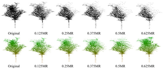
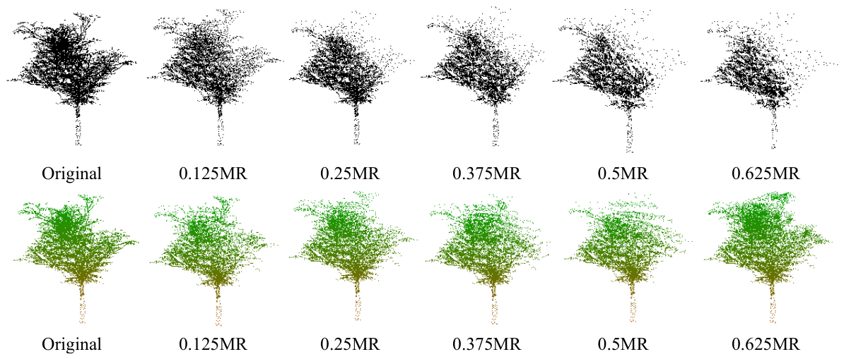
Incomplete point clouds were generated from the TreeNet3D dataset under different missing conditions based on the simulated missing-pattern generation strategy described in Section 3.1. Five missing ratios were considered, including 12.5%, 25%, 37.5%, 50%, and 62.5%. Examples of the simulated incomplete point clouds are shown in Figure 4. The 62.5% setting was treated as a severe occlusion condition similar to those encountered in practical LiDAR acquisition. Instead of completely removing points inside the missing regions, a small number of sparse points were retained to approximate partial occlusion artifacts and irregular sampling effects observed in real scans. For the TreeNet3D dataset, quantitative comparisons with representative baseline methods under the 25% missing setting are reported in Table 1 and Table 2. The performance under different missing ratios is further summarized in Table 3.
Figure 4.
The figure presents examples of point cloud samples with different missing ratios generated from TreeNet3D using the proposed simulation strategy, along with their corresponding completion results. The first row shows the incomplete point clouds, while the second row presents the completed outputs. As the missing ratio increases, the missing regions become larger, and the point density within these regions gradually decreases.
Table 1.
Quantitative results on the TreeNet3D dataset at 25% masking ratio in terms of CD_L1 (). Latin species names are abbreviated using genus initials. The best results are highlighted in boldface. All ten species in the TreeNet3D dataset were included in the training and testing procedures. For brevity and readability, results for five representative species with diverse tree architectures and canopy structures are reported. (Bold font denotes the best results. All methods were evaluated over five independent runs with different random seeds. Improvements achieved by GS-TreeAttn over all competing methods are statistically significant (paired t-test, p < 0.05)).
Table 2.
Quantitative results on the TreeNet3D dataset at 25% masking ratio in terms of F-Score@1%. Latin species names are abbreviated using genus initials. The best results are highlighted in boldface. All ten species in the TreeNet3D dataset were included in the training and testing procedures. For brevity and readability, results for five representative species with diverse tree architectures and canopy structures are reported. (Bold font denotes the best results. All methods were evaluated over five independent runs with different random seeds. Improvements achieved by GS-TreeAttn over all competing methods are statistically significant (paired t-test, p < 0.05)).
Table 3.
Performance comparison between GS-TreeAttn and PointAttN under different mask ratios.
Table 3 compares PointAttN and GS-TreeAttn under different occlusion settings. Across all missing ratios, GS-TreeAttn produces lower reconstruction errors and more stable recovery of tree structures from incomplete point clouds. Visual reconstruction results are shown in Figure 4. In the rendered point clouds, colors vary with height, with trunk regions displayed in brown and canopy regions shown in green.
GS-TreeAttn achieves lower reconstruction errors than PointAttN across all occlusion settings from 12.5% to 62.5%. Under the 12.5% missing condition, the CD-L1 decreases from 7.21 to 5.78, while RMSE is reduced from 0.067 to 0.063. Similar trends can be observed at 25%, 37.5%, and 50% occlusion levels. The most pronounced RMSE improvement appears at the 37.5% missing ratio, where both geometric accuracy and structural continuity are noticeably enhanced. Model performance declines as the missing ratio increases, especially under the 62.5% occlusion setting. In this case, PointAttN produces fragmented structures in sparse canopy regions, whereas GS-TreeAttn still preserves the main branching topology. The proposed model achieves a CD-L1 of 6.21 and an RMSE of 0.078, compared with 8.46 and 0.085 for PointAttN, respectively. This behavior suggests that combining structural priors with density-aware feature aggregation improves reconstruction stability when local observations become sparse or irregular.
Some limitations remain under severe occlusion. As shown in Figure 4, large continuous missing regions occasionally lead to deviations from the original branch geometry, particularly near tree crowns with limited observations. In these regions, insufficient structural information weakens geometric constraints during reconstruction. Additional comparisons were conducted under the 25% missing setting using several representative baseline methods, including SK-TreePCN. Quantitative results are reported in Table 1 and Table 2. GS-TreeAttn achieves the lowest CD-L1 value of 5.84 together with the highest F1-score of 0.802. Traditional methods such as TopNet, PCN, and GRNet show relatively large reconstruction errors on complex tree structures. Transformer-based methods, including PoinTr, improve overall reconstruction quality but still exhibit discontinuities in sparse regions. SeedFormer and PointAttN further reduce reconstruction errors, although their performance remains lower than that of GS-TreeAttn.
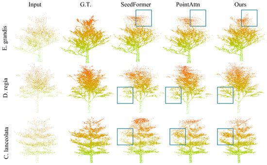
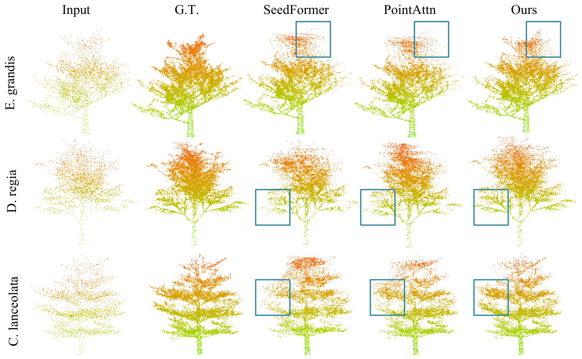
Compared with SK-TreePCN, the proposed method reduces CD-L1 from 6.48 to 5.84 and increases the F1-score from 0.765 to 0.802. Relative to PointAttN, the CD-L1 decreases by 19.8%, while the F1-score increases from 0.744 to 0.802. Visual comparisons in Figure 5 show that GS-TreeAttn reconstructs canopy structures more smoothly in heavily occluded regions. Fine branches can still be recovered from sparse observations because structural and neighborhood features are aggregated jointly during attention-based feature learning. The feature enhancement module in the Seed Generator also helps suppress redundant points, producing cleaner crown structures and smoother geometric transitions.
Figure 5.
Visualization comparison of point cloud completion results on the TreeNet3D dataset, where GS-TreeAttn generates more detailed point clouds. (Colors indicate height values, with brown representing lower regions and green representing higher regions. Blue boxes highlight representative local regions for detailed comparison).
Figure 5 presents a visual comparison between the proposed method and representative completion methods, including SeedFormer and PointAttN. The visualization results show that our method effectively addresses the challenges of local feature extraction, while the introduction of structural features enables the model to generate more refined and accurate point clouds. For example, in severely missing tree-top regions, the model is able to reconstruct fine branches from only a few points, since GS-TreeAttn can globally select and aggregate neighborhood and structural features through attention weights. In addition, the feature enhancement network in the seed generator further enhances the model’s feature capture ability and reduces redundant points, which is particularly evident in the tree-top region, resulting in smoother and more structurally clear point clouds.
3.3. Results Under Simulated LiDAR Acquisition
Since the simulated missing patterns we adopt may not fully represent real-world conditions, we utilize the LiDAR simulation functionality provided in LESS [36] to emulate the data acquisition process. The generated incomplete point clouds are then applied to the test set. Instead of using heuristic point removal strategies, we approximate realistic scanning processes by explicitly defining sensor trajectories and acquisition parameters. All LiDAR-simulated point clouds are generated from the original TreeNet3D dataset.
For MLS-like simulation, a linear sensor trajectory is defined along the ground in the x-axis direction to mimic a moving scanning scenario. The virtual sensor is placed at a height of 1.5 m above the ground, with scanning positions generated at intervals of 0.5 m. At each position, a spherical scanning pattern is applied with a horizontal field of view of and a vertical field of view of . The point cloud is further downsampled based on visibility and distance to the sensor, resulting in single-sided coverage and occlusion effects similar to real MLS data. For airborne laser scanning (ALS)-like simulation, the virtual sensor is positioned 20 m above the scene to approximate airborne acquisition. A nadir-view scanning configuration is adopted with a field of view of , and a ground sampling grid spacing of 0.2 m. The resulting sampling density decreases with increasing distance from the nadir direction, while lower canopy and trunk regions are partially occluded due to the top-down acquisition geometry. All simulations are conducted under the same software environment and parameter settings to ensure fairness. The generated point clouds capture key geometric characteristics of real ALS and MLS acquisitions, including viewpoint-dependent occlusions and non-uniform sampling density, while maintaining full control over experimental conditions.
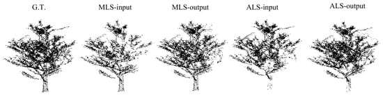
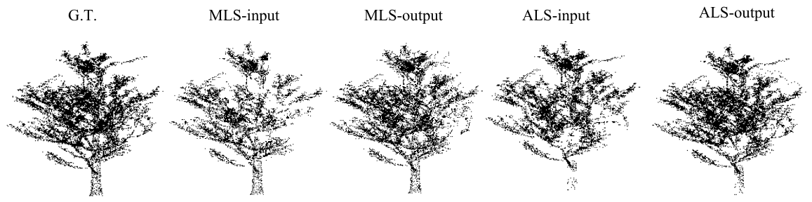
The model is trained on synthetic incomplete data and evaluated on LiDAR-simulated point clouds. The quantitative results are presented in Table 4, and the corresponding qualitative results are shown in Figure 6. It can be observed that the proposed method maintains strong performance under simulated LiDAR acquisition conditions. The visualization results further demonstrate that the model is able to preserve the overall tree structure and generate relatively complete point clouds, even in the presence of realistic occlusion patterns.
Table 4.
Performance comparison under simulated LiDAR acquisition scenarios. (↑ indicates higher values are better, ↓ indicates lower values are better, and the best results are highlighted in bold).
Figure 6.
The figure shows ALS-like and MLS-like point clouds generated using the LESS framework. “MLS-input” and “ALS-input” represent the simulated incomplete point clouds under MLS-like and ALS-like acquisition, respectively, while “MLS-output” and “ALS-output” denote the corresponding completion results. The comparison highlights the different occlusion patterns and reconstruction performance under the two acquisition scenarios.
3.4. Results on the FOR-Species20k Data
Table 5 compares the completion performance of PointAttN and GS-TreeAttn under different missing ratios. Similar trends to those observed on TreeNet3D can be found across all occlusion settings, where GS-TreeAttn consistently achieves lower reconstruction errors. Under the 12.5% missing condition, CD-L1 decreases from 7.21 to 5.78, while RMSE is reduced from 0.068 to 0.061. The advantage remains stable as the missing ratio increases, with noticeable improvements in both geometric accuracy and structural recovery. Compared with TreeNet3D, the performance gap between the two methods follows a slightly different trend on this dataset. The difference becomes larger again under severe occlusion, particularly at the 62.5% missing level, where the CD-L1 and RMSE improvements reach 25.64% and 11.76%, respectively. Even under substantial data loss, GS-TreeAttn maintains relatively stable reconstruction quality. In sparse regions with limited observations, the reconstructed branch structures remain more continuous than those produced by PointAttN. This behavior is related to the use of structural priors during feature aggregation, which helps preserve geometric consistency when point distributions become highly irregular.
Table 5.
Comparison of completion performance under different occlusion ratios.
Table 6 summarizes the reconstruction results under the 37.5% occlusion setting. GS-TreeAttn achieves the lowest CD-L1 value of 5.89 and the highest F1-score of 0.803 among all compared methods. Relative to PointAttN, CD-L1 decreases by 20.08%, while the F1-score increases by 5.78%. The difference becomes larger when compared with earlier completion methods. For example, GS-TreeAttn reduces the CD-L1 from 11.36 to 5.89 relative to TopNet, corresponding to a 48.15% reduction in reconstruction error. Visual inspection also shows that the proposed model preserves branch continuity more effectively in sparse and incomplete canopy regions.
Table 6.
Comparison of different methods at 37.5% masking ratio. (↑ indicates higher values are better, ↓ indicates lower values are better, and the best results are highlighted in bold).
3.5. Effect of Point Cloud Completion on Tree Height Estimation
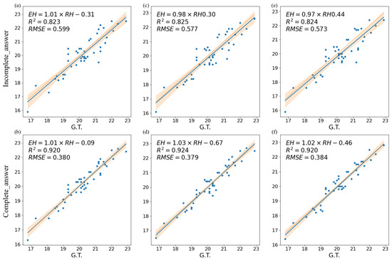
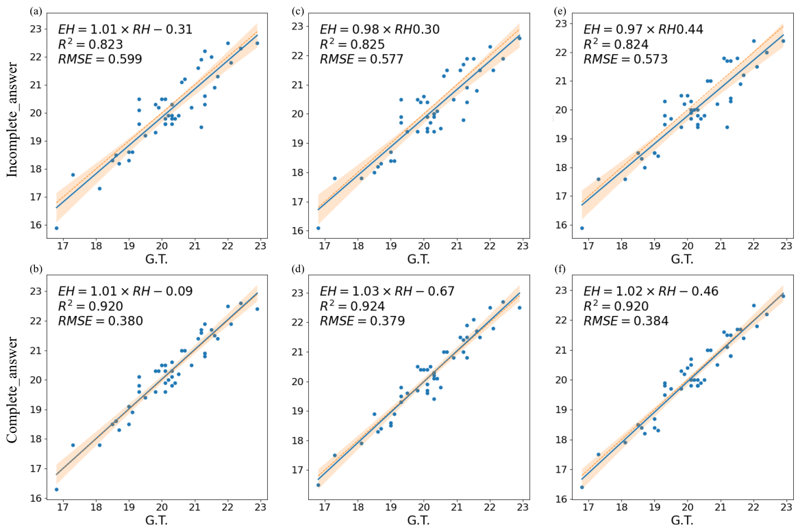
To evaluate whether the completed point clouds generated by GS-TreeAttn improve the accuracy of parameter extraction, tree height was estimated before and after point cloud completion. To ensure robustness, three commonly used estimation methods were adopted: (1) direct height difference between the highest and lowest points, (2) the 95th percentile height method, and (3) the local maximum treetop method. As illustrated in Figure 7, the upper row shows the estimation results before completion, while the lower row presents the results after completion. All three methods exhibit consistent improvements after point cloud completion. Specifically, the R2 values increase from 0.823, 0.825, and 0.824 to 0.920, 0.924, and 0.920, corresponding to improvements of approximately 11–12%. Meanwhile, the RMSE values decrease from 0.599, 0.577, and 0.573 to 0.380, 0.379, and 0.384, representing a reduction of approximately 33%.
Figure 7.
Comparative analysis of tree height estimation, where (a,c,e) show the tree height fitting results based on incomplete point clouds and (b,d,f) show the tree height fitting result based on complete point clouds.
The improvement in tree height estimation is mainly related to the recovery of missing crown regions and the reduction of irregular point distribution in incomplete observations. In sparse or partially occluded point clouds, missing treetop information often results in underestimated height measurements or unstable predictions. After completion, the reconstructed point clouds provide more continuous vertical structures, which improves the identification of tree tops and canopy extent. A similar trend can be observed across the three estimation methods. This suggests that the reconstructed point clouds preserve the overall geometric structure of trees while reducing the influence of local missing regions. The effect is particularly noticeable in trees affected by severe occlusion, where incomplete crown structures can strongly influence height estimation results. More stable tree height measurements may further benefit downstream tasks such as biomass estimation, forest inventory, and ecological analysis.
3.6. Ablation Study
To further evaluate the contribution of each component in the proposed architecture, we conduct an ablation study by selectively enabling individual modules on top of a baseline model. All experiments are performed on the TreeNet3D dataset, where missing patterns are simulated to mimic MLS data characteristics, with a fixed occlusion ratio of 25%. The performance is evaluated using CD-L1 and F1-score metrics. Four configurations are considered: (1) the baseline model without any additional components; (2) a variant with only the HSFA module; (3) a variant with only the GAN module; and (4) the full model (GS-TreeAttn), which integrates skeletal point clouds, HSFA, and GAN. To ensure a fair comparison, all configurations are trained using identical hyperparameters, optimization strategies, and training data. When HSFA is removed, the GDP and SFA modules from PointAttn are used as substitutes. The results are summarized in Table 7. Incorporating the HSFA module significantly improves performance, reducing CD-L1 from 7.53 to 6.14 (an 18.46% improvement) and increasing the F1-score from 0.731 to 0.792. Introducing the GAN module also leads to performance gains, achieving a CD-L1 of 6.82 and an F1-score of 0.752, indicating that adversarial learning helps improve feature realism and geometric completeness. The full model (GS-TreeAttn) achieves the best performance, with a CD-L1 of 5.84 and an F1-score of 0.801. Compared with the baseline, this corresponds to a 22.44% reduction in CD-L1 and a notable improvement in F1-score. These results demonstrate that while both HSFA and GAN contribute individually to performance improvements, their integration with structural priors (skeletal representation) produces a clear synergistic effect. Although HSFA already achieves strong performance in terms of F1-score, the integration of GAN further improves geometric completeness and structural consistency, leading to the best overall performance. Overall, the performance gains can be attributed to the complementary roles of multi-scale feature extraction (HSFA), enhanced feature generation (GAN), and structural guidance provided by skeletal representations, enabling more accurate and structurally consistent tree point cloud reconstruction.
Table 7.
Ablation study on the contribution of key components in GS-TreeAttn. “SK-Point” denotes the skeleton point representation extracted using the L1 skeleton extraction algorithm and used as structural guidance in the proposed framework. The best results are highlighted in bold.
While the above ablation validates the effectiveness of individual components, it does not explicitly verify the core design motivation of our method.
To further validate the effectiveness of the proposed coupling between structure and density, we conduct additional ablation experiments by decoupling structural and density-aware components. As shown in Table 8, both the structure-only and density-only variants improve performance over the baseline, indicating that each factor independently contributes to point cloud completion. The simple fusion strategy, which combines structural and density features without explicit interaction modeling, achieves further improvement. However, the proposed coupled model significantly outperforms all variants, achieving the lowest CD-L1 and highest F1-score. This demonstrates that explicitly modeling the interaction between structural priors and density heterogeneity is crucial for accurate reconstruction. These results confirm that tree point cloud completion is inherently a structure–density coupled problem, and treating them independently leads to suboptimal performance.
Table 8.
Ablation study on the structure–density coupling mechanism. The symbols “↓” and “↑” indicate that lower and higher values correspond to better performance, respectively. The best results are highlighted in bold.
To evaluate the sensitivity of the proposed method to different skeleton extraction strategies, we conduct an ablation study by replacing the default skeletonization module with alternative methods. Specifically, we consider three types of skeleton representations: (1) a graph-based minimum spanning tree (MST) approach, (2) a voxel-based thinning method, and (3) the default method used in our framework (L1 skeleton extractor), These methods represent different structural modeling strategies. The results are shown in Table 9, the performance of GS-TreeAttn remains relatively stable across different skeleton extraction methods, with only minor variations in evaluation metrics. This indicates that the proposed model is robust to the choice of skeleton representation and does not rely on a specific skeletonization technique.
Table 9.
Impact of different skeleton extraction methods on completion performance. The symbols “↓” and “↑” indicate that lower and higher values correspond to better performance, respectively. The best results are highlighted in bold.
4. Discussion
The proposed framework maintains relatively stable performance under varying occlusion levels and heterogeneous point cloud distributions. Ablation results show that both the skeleton-guided representation and the HSFA module contribute to reconstruction quality, with the best performance achieved when combined. The improvement is more evident in sparse canopy regions, where incomplete observations often disrupt local geometric continuity. As the missing rate increases, GS-TreeAttn demonstrates a clearer advantage over baseline methods. Under severe occlusion, many existing approaches struggle to preserve continuous branch structures due to insufficient local geometric cues. In contrast, GS-TreeAttn can still recover the main tree topology from limited observations, although reconstruction accuracy degrades when structural fragmentation becomes extreme.
Nevertheless, limitations remain under extreme missing conditions. When large continuous regions are absent, the reconstructed point clouds may contain redundant points or locally inconsistent geometries.This phenomenon may be related to the increased reliance on global structural priors when local context becomes insufficient, which can occasionally produce overly smooth or unrealistic branch patterns. Performance gains are less significant under relatively uniform missing patterns. For example, at 37.5% occlusion, improvements are smaller compared to more severe and structured occlusion cases, since weaker structural discontinuities reduce the benefit of structure-guided feature aggregation. We further evaluate the runtime efficiency of the proposed model, as shown in Table 10. Due to the computationally expensive L1 skeleton extraction used in the data preprocessing stage, as well as the additional attention and structural encoding operations introduced by GS-TreeAttn, the overall computational cost is relatively high. Although this is still acceptable under the current experimental settings, it may limit the scalability of the method in large-scale urban forestry applications.
Table 10.
Quantitative comparison of reconstruction performance and efficiency. CD denotes Chamfer Distance. Lower is better for all metrics. The best results are highlighted in bold.
The training data is based on simulated missing patterns, which approximate LiDAR occlusion but cannot fully capture real-world complexity such as dense canopy overlap and seasonal variation. This may affect generalization in practical deployments. Overall, GS-TreeAttn is effective under severe structured occlusion, but handling large continuous missing regions remains challenging. Future work will explore more robust structural constraints and realistic data simulation strategies for improved real-world performance.
5. Conclusions
GS-TreeAttn improves tree point cloud completion on incomplete lidar observation data by combining structural priors and density-adaptive feature aggregation. This framework exhibits stable reconstruction performance under varying degrees of occlusion and heterogeneous sampling conditions, particularly in sparse canopy regions with missing branches and irregular point cloud distribution. Experiments on both synthetic and field-collected datasets demonstrate more continuous branch reconstruction and improved stability in downstream tree height estimation. Several challenges remain in the current framework. Large continuous missing regions can still lead to locally inconsistent geometry, especially in heavily occluded crown areas. In addition, the attention-based architecture introduces higher computational cost than lightweight completion networks. The current experiments are also mainly based on simulated missing patterns and urban tree scenes, so further evaluation is still needed for complex forest environments and natural occlusion conditions. Large-scale forest reconstruction and temporal LiDAR observations remain challenging problems. More realistic missing-pattern simulation and lightweight reconstruction strategies may help improve robustness and computational efficiency in future applications. Extending the framework to multi-source and long-term ecological monitoring datasets is another possible direction for subsequent research.
Author Contributions
Conceptualization, H.L. and L.L.; Methodology, H.L.; Software, H.L.; Validation, W.Z. and W.J.; Formal Analysis, H.L.; Investigation, H.L.; Data Curation, W.Z. and W.J.; Writing—Original Draft Preparation, H.L.; Writing—Review and Editing, L.L.; Visualization, H.L.; Supervision, L.L.; Funding Acquisition, L.L. All authors have read and agreed to the published version of the manuscript.
Funding
This research was funded by the Fundamental Research Funds for the Central Universities, Grant No. 2572023CT16.
Data Availability Statement
The data used in this study are available from the corresponding author upon reasonable request.
Acknowledgments
The authors would like to thank colleagues and collaborators for their support during this research.
Conflicts of Interest
The authors declare no conflict of interest.
References
- Guo, Y.; Wang, H.; Hu, Q.; Liu, H.; Liu, L.; Bennamoun, M. Deep Learning for 3D Point Clouds: A Survey. IEEE Trans. Pattern Anal. Mach. Intell. 2021, 43, 4338–4364. [Google Scholar] [CrossRef] [Scilit] [PubMed]
- Weiser, H.; Schäfer, J.; Winiwarter, L.; Krašovec, N.; Fassnacht, F.E.; Höfle, B. Individual tree point clouds and tree measurements from multi-platform laser scanning in German forests. Earth Syst. Sci. Data 2022, 14, 2989–3012. [Google Scholar] [CrossRef] [Scilit]
- Ye, Q.; Zhao, Z. Remote Sensing Based Modeling of Forest Structural Parameters: Advances and Challenges. Forests 2026, 17, 209. [Google Scholar] [CrossRef] [Scilit]
- Coops, N.C.; Tompalski, P.; Goodbody, T.R.; Queinnec, M.; Luther, J.E.; Bolton, D.K.; White, J.C.; Wulder, M.A.; van Lier, O.R.; Hermosilla, T. Modelling lidar-derived estimates of forest attributes over space and time: A review of approaches and future trends. Remote Sens. Environ. 2021, 260, 112477. [Google Scholar] [CrossRef] [Scilit]
- Liang, X.; Kankare, V.; Hyyppä, J.; Wang, Y.; Kukko, A.; Haggrén, H.; Yu, X.; Kaartinen, H.; Jaakkola, A.; Guan, F.; et al. Terrestrial laser scanning in forest inventories. ISPRS J. Photogramm. Remote Sens. 2016, 115, 63–77. [Google Scholar] [CrossRef] [Scilit]
- Chen, S.; Feng, Z.; Chen, P.; Ullah Khan, T.; Lian, Y. Nondestructive Estimation of the Above-Ground Biomass of Multiple Tree Species in Boreal Forests of China Using Terrestrial Laser Scanning. Forests 2019, 10, 936. [Google Scholar] [CrossRef] [Scilit]
- Popescu, S.C. Estimating tree crown diameter with LiDAR. Photogramm. Eng. Remote Sens. 2007, 73, 589–597. [Google Scholar] [CrossRef] [Scilit]
- Jakubowski, M.K.; Guo, Q.; Kelly, M. LiDAR-based estimation of forest structure. Remote Sens. Environ. 2013, 128, 15–26. [Google Scholar]
- Newnham, G.J.; Armston, J.D.; Calders, K.; Disney, M.I.; Lovell, J.L.; Schaaf, C.B.; Strahler, A.H.; Danson, F.M. Terrestrial laser scanning for plot-scale forest measurement. Curr. For. Rep. 2015, 1, 239–251. [Google Scholar] [CrossRef] [Scilit]
- Raumonen, P.; Kaasalainen, M.; Åkerblom, M.; Kaasalainen, S.; Kaartinen, H.; Vastaranta, M.; Holopainen, M.; Disney, M.; Lewis, P. Fast automatic precision tree models from terrestrial laser scanner data. Remote Sens. 2013, 5, 491–520. [Google Scholar] [CrossRef] [Scilit]
- Disney, M. Terrestrial LiDAR: A three-dimensional revolution in how we look at trees. New Phytol. 2019, 222, 1736–1741. [Google Scholar] [CrossRef] [Scilit] [PubMed]
- Calders, K.; Adams, J.; Armston, J.; Bartholomeus, H.; Bauwens, S.; Bentley, L.P.; Chave, J.; Danson, F.M.; Demol, M.; Disney, M.; et al. Terrestrial laser scanning in forest ecology: Expanding the horizon. Remote Sens. Environ. 2020, 251, 112102. [Google Scholar] [CrossRef] [Scilit]
- Bogdanovich, E.; Perez-Priego, O.; El-Madany, T.S.; Guderle, M.; Pacheco-Labrador, J.; Levick, S.R.; Moreno, G.; Carrara, A.; Pilar Martín, M.; Migliavacca, M. Using terrestrial laser scanning for characterizing tree structural parameters and their changes under different management in a Mediterranean open woodland. For. Ecol. Manag. 2021, 486, 118945. [Google Scholar] [CrossRef] [Scilit]
- Charles, R.Q.; Su, H.; Kaichun, M.; Guibas, L.J. PointNet: Deep Learning on Point Sets for 3D Classification and Segmentation. In Proceedings of the 2017 IEEE Conference on Computer Vision and Pattern Recognition (CVPR), Honolulu, HI, USA, 21–26 July 2017; pp. 77–85. [Google Scholar] [CrossRef] [Scilit]
- Yu, X.; Rao, Y.; Wang, Z.; Liu, Z.; Lu, J.; Zhou, J. PoinTr: Diverse Point Cloud Completion with Geometry-Aware Transformers. In Proceedings of the IEEE/CVF International Conference on Computer Vision (ICCV), Montreal, QC, Canada, 10–17 October 2021; pp. 12498–12507. [Google Scholar]
- Yuan, W.; Khot, T.; Held, D.; Mertz, C.; Hebert, M. PCN: Point Completion Network. In Proceedings of the 2018 International Conference on 3D Vision (3DV), Verona, Italy, 5–8 September 2018; pp. 728–737. [Google Scholar] [CrossRef] [Scilit]
- Tchapmi, L.P.; Kosaraju, V.; Rezatofighi, H.; Reid, I.; Savarese, S. TopNet: Structural Point Cloud Decoder. In Proceedings of the 2019 IEEE/CVF Conference on Computer Vision and Pattern Recognition (CVPR), Long Beach, CA, USA, 15–20 June 2019; pp. 383–392. [Google Scholar] [CrossRef] [Scilit]
- Xie, H.; Yao, H.; Zhou, S.; Mao, J.; Zhang, S.; Sun, W. GRNet: Gridding Residual Network for Dense Point Cloud Completion. In Proceedings of the Computer Vision—ECCV 2020; Vedaldi, A., Bischof, H., Brox, T., Frahm, J.M., Eds.; Springer Nature: Cham, Switzerland, 2020; pp. 365–381. [Google Scholar]
- Pan, L.; Chen, X.; Cai, Z.; Zhang, J.; Zhao, H.; Yi, S.; Liu, Z. Variational Relational Point Completion Network. In Proceedings of the IEEE/CVF Conference on Computer Vision and Pattern Recognition (CVPR), Nashville, TN, USA, 20–25 June 2021; pp. 8524–8533. [Google Scholar]
- Yu, X.; Rao, Y.; Wang, Z.; Lu, J.; Zhou, J. AdaPoinTr: Diverse Point Cloud Completion with Adaptive Geometry-Aware Transformers. IEEE Trans. Pattern Anal. Mach. Intell. 2023, 45, 14114–14130. [Google Scholar] [CrossRef] [Scilit] [PubMed]
- Zhou, H.; Cao, Y.; Chu, W.; Zhu, J.; Lu, T.; Tai, Y.; Wang, C. SeedFormer: Patch Seeds Based Point Cloud Completion with Upsample Transformer. In Proceedings of the Computer Vision—ECCV 2022; Avidan, S., Brostow, G., Cissé, M., Farinella, G.M., Hassner, T., Eds.; Springer Nature: Cham, Switzerland, 2022; pp. 416–432. [Google Scholar]
- Qian, G.; Abualshour, A.; Li, G.; Thabet, A.; Ghanem, B. SnowflakeNet: Point Cloud Completion by Snowflake Point Deconvolution with Skip-Transformer. In Proceedings of the IEEE/CVF International Conference on Computer Vision (ICCV), Montreal, QC, Canada, 10–17 October 2021. [Google Scholar]
- Yu, X.; Tang, L.; Rao, Y.; Huang, T.; Zhou, J.; Lu, J. Point-BERT: Pre-training 3D Point Cloud Transformers with Masked Point Modeling. In Proceedings of the 2022 IEEE/CVF Conference on Computer Vision and Pattern Recognition (CVPR), New Orleans, LA, USA, 18–24 June 2022; pp. 19291–19300. [Google Scholar] [CrossRef] [Scilit]
- Qian, G.; Li, Y.; Peng, H.; Mai, J.; Hammoud, H.; Elhoseiny, M.; Ghanem, B. PointNeXt: Revisiting PointNet++ with Improved Training and Scaling Strategies. In Proceedings of the Advances in Neural Information Processing Systems; Koyejo, S., Mohamed, S., Agarwal, A., Belgrave, D., Cho, K., Oh, A., Eds.; Curran Associates, Inc.: Red Hook, NY, USA, 2022; Volume 35, pp. 23192–23204. [Google Scholar]
- Li, Y.; Peng, F.; Dou, F.; Xiao, Y.; Li, Y. PCCDiff: Point Cloud Completion with Conditional Denoising Diffusion Probabilistic Models. Symmetry 2024, 16, 1680. [Google Scholar] [CrossRef] [Scilit]
- Xu, H.; Huai, Y.; Zhao, X.; Meng, Q.; Nie, X.; Li, B.; Lu, H. SK-TreePCN: Skeleton-Embedded Transformer Model for Point Cloud Completion of Individual Trees from Simulated to Real Data. Remote Sens. 2025, 17, 656. [Google Scholar] [CrossRef] [Scilit]
- Li, S.; Gao, P.; Tan, X.; Wei, M. ProxyFormer: Proxy Alignment Assisted Point Cloud Completion with Missing Part Sensitive Transformer. In Proceedings of the 2023 IEEE/CVF Conference on Computer Vision and Pattern Recognition (CVPR), Vancouver, BC, Canada, 17–24 June 2023; pp. 9466–9475. [Google Scholar] [CrossRef] [Scilit]
- Xu, J.; Wan, Z.; Wei, J. Learning Contours for Point Cloud Completion. Remote Sens. 2023, 15, 4338. [Google Scholar] [CrossRef] [Scilit]
- Tesema, K.W.; Hill, L.; Jones, M.W.; Ahmad, M.I.; Tam, G.K. Point Cloud Completion: A Survey. IEEE Trans. Vis. Comput. Graph. 2024, 30, 6880–6899. [Google Scholar] [CrossRef] [Scilit] [PubMed]
- Thomas, H.; Qi, C.R.; Deschaud, J.E.; Marcotegui, B.; Goulette, F.; Guibas, L.J. KPConv: Flexible and Deformable Convolution for Point Clouds. In Proceedings of the IEEE/CVF International Conference on Computer Vision (ICCV), Seoul, Republic of Korea, 27 October–2 November 2019. [Google Scholar]
- Huang, H.; Wu, S.; Cohen-Or, D.; Gong, M.; Zhang, H.; Li, G.; Chen, B. L1-medial skeleton of point cloud. ACM Trans. Graph. 2013, 32, 1–8. [Google Scholar] [CrossRef] [Scilit]
- Wu, X.; Wu, X.; Luan, T.; Bai, Y.; Lai, Z.; Yuan, J. FSC: Few-point Shape Completion. In Proceedings of the IEEE/CVF Conference on Computer Vision and Pattern Recognition (CVPR), Seattle, WA, USA, 16–22 June 2024; pp. 26077–26087. [Google Scholar]
- Wang, J.; Cui, Y.; Guo, D.; Li, J.; Liu, Q.; Shen, C. PointAttN: You Only Need Attention for Point Cloud Completion. Proc. AAAI Conf. Artif. Intell. 2024, 38, 5472–5480. [Google Scholar] [CrossRef] [Scilit]
- Tang, S.; Ao, Z.; Li, Y.; Huang, H.; Xie, L.; Wang, R.; Wang, W.; Guo, R. TreeNet3D: A large scale tree benchmark for 3D tree modeling, carbon storage estimation and tree segmentation. Int. J. Appl. Earth Obs. Geoinf. 2024, 130, 103903. [Google Scholar] [CrossRef] [Scilit]
- Puliti, S.; Lines, E.R.; Müllerová, J.; Frey, J.; Schindler, Z.; Straker, A.; Allen, M.J.; Winiwarter, L.; Rehush, N.; Hristova, H.; et al. Benchmarking tree species classification from proximally sensed laser scanning data: Introducing the FOR-species20K dataset. Methods Ecol. Evol. 2025, 16, 801–818. [Google Scholar] [CrossRef] [Scilit]
- Qi, J.; Xie, D.; Yin, T.; Yan, G.; Gastellu-Etchegorry, J.P.; Li, L.; Zhang, W.; Mu, X.; Norford, L.K. LESS: LargE-Scale remote sensing data and image simulation framework over heterogeneous 3D scenes. Remote Sens. Environ. 2019, 221, 695–706. [Google Scholar] [CrossRef] [Scilit]

Disclaimer/Publisher’s Note: The statements, opinions and data contained in all publications are solely those of the individual author(s) and contributor(s) and not of MDPI and/or the editor(s). MDPI and/or the editor(s) disclaim responsibility for any injury to people or property resulting from any ideas, methods, instructions or products referred to in the content. |
© 2026 by the authors. Licensee MDPI, Basel, Switzerland. This article is an open access article distributed under the terms and conditions of the Creative Commons Attribution (CC BY) license.