


Highlights
What are the main findings?
- A dense optical flow method can retrieve wildfire smoke plume motion from geostationary, deep-space, and airborne remote sensing imagery.
- Across multiple wildfire cases, the method improved alignment between image pairs and produced consistent smoke motion vectors under different spatial and temporal sampling conditions.
What are the implications of the main findings?
- Remote sensing imagery can be used not only to detect wildfire smoke but also to quantify how smoke plumes move and evolve over time.
- The resulting smoke motion vectors can support plume analysis, comparison with model winds, and future wildfire hazard-monitoring applications.
Abstract
This paper evaluates a dense, total-variation-based optical flow method for retrieving wildfire smoke plume motion vectors from geostationary, deep-space, and airborne remote sensing imagery. Using multiple major fire events, we assess the robustness of the approach across a range of spatial resolutions and time intervals. The test cases include Geostationary Operational Environmental Satellite (GOES) observations of the 2025 Los Angeles Fires and the 2024 Park Fire, imagery from NASA’s Enhanced MODIS Airborne Simulator (eMAS) for the 2019 Sheridan and Williams Flats Fires, and a complementary Park Fire image pair from the Earth Polychromatic Imaging Camera (EPIC) aboard the Deep Space Climate Observatory (DSCOVR). Optical flow is computed directly on radiance fields, and smoke plumes are isolated using smoke masks derived from the Segmentation, Instance Tracking, and data Fusion Using multi-SEnsor imagery (SIT-FUSE) framework where available. Performance is evaluated by comparing the root mean square error (RMSE) between original image pairs and between the first image and the second image after warping with the retrieved motion field. RMSE is computed both globally and over smoke-only regions. Across GOES and eMAS cases, optical flow systematically reduces RMSE, often by more than a factor of two within smoke regions, indicating substantially improved frame-to-frame alignment of plume structures after motion correction. The DSCOVR/EPIC case, despite its coarser spatial resolution and longer temporal separation, also shows a marked reduction in global RMSE, demonstrating that the method remains informative under a broader range of observational conditions. For a selected subset of 10 consecutive GOES Park Fire pairs, we additionally compare the retrieved smoke motion vectors with collocated winds from the High-Resolution Rapid Refresh (HRRR) model and find the closest agreement in a broad lower-tropospheric layer centered near 875 hPa. These results show that dense optical flow can capture fine-scale plume evolution in high-temporal-resolution datasets while also providing useful motion estimates in coarser, global-view imagery. RMSE reduction is interpreted here as evidence of improved motion-compensated alignment, while the HRRR comparison provides initial physical context rather than independent validation. The resulting smoke motion vector fields provide a foundation for future comparison with model winds and for applications in plume analysis, fire hazard monitoring, and air quality studies.
1. Introduction
Wildfires are increasing in frequency, severity, and spatial extent, posing growing threats to public health, infrastructure, and ecosystems [1,2,3,4]. The smoke plumes generated by these events can be transported over large distances, degrading air quality far from the source and complicating situational awareness and response [1,2,5,6]. Monitoring and characterizing the motion of wildfire smoke plumes is therefore critical for understanding their dispersion, evaluating air quality impacts, constraining and validating transport models, and improving forecasting and decision-making tools for hazard mitigation [7,8].
Spaceborne and airborne remote sensing offer unique capabilities for observing wildfire smoke, providing broad spatial coverage and repeated sampling during active events [9,10,11]. Geostationary imagers such as NOAA’s Geostationary Operational Environmental Satellite (GOES) provide high-temporal-resolution views of plume evolution, while instruments such as NASA’s Enhanced MODIS Airborne Simulator (eMAS) deliver fine spatial detail over targeted scenes [9,12]. More distant platforms, such as the Earth Polychromatic Imaging Camera (EPIC) instrument aboard the Deep Space Climate Observatory (DSCOVR), provide complementary global-view observations [13,14,15]. However, converting these radiance fields into quantitative estimates of horizontal smoke motion remains challenging. Traditional approaches often rely on relatively sparse feature tracking or on model-based wind fields which may not fully capture plume-scale transport. This is especially true in complex or rapidly evolving flow regimes [16,17]. At the same time, model wind products provide an important point of reference for interpreting the retrieved smoke motion vectors and assessing their consistency with the surrounding meteorological environment [18].
Optical flow, which was originally developed in the computer vision community, has been adapted for atmospheric motion estimation and generates dense and high-resolution retrievals of horizontal motion fields directly from image sequences. In previous work, a total-variation (TV)–based optical flow algorithm was systematically evaluated for Atmospheric Motion Vector (AMV) retrieval from water vapor imagery using high-resolution numerical simulations across multiple weather regimes and time intervals [19]. In that study, the total-variation (TV)–L1 implementation consistently outperformed a state-of-the-art pattern-matching algorithm [16] and showed reduced sensitivity to temporal separation and flow complexity, with the retrieved AMVs closely resembling the simulated winds. These results demonstrate that dense optical flow provides a robust and physically consistent way to derive atmospheric motion from satellite imagery.
This paper extends that framework to wildfire smoke applications. To our knowledge, this is the first systematic application of a dense optical flow framework to wildfire smoke motion retrieval across geostationary, deep-space, and airborne remote sensing datasets, together with smoke-specific evaluation using SIT-FUSE masks and an initial comparison with collocated model winds. We explore the performance of a dense TV–L1 optical flow method for retrieving motion vectors of smoke plumes from geostationary, deep-space, and airborne remote sensing datasets. Smoke plume motion datasets are generated for multiple major fire events that have varying spatial and temporal resolution, including the 2025 Los Angeles Fires and the 2024 Park Fire observed by GOES, the 2019 Sheridan and Williams Flats Fires observed by eMAS, and a complementary 2024 Park Fire image pair observed by DSCOVR/EPIC. Smoke regions are isolated using masks from the Segmentation, Instance Tracking, and data Fusion Using multi-SEnsor imagery (SIT-FUSE) framework, where available, which has demonstrated efficacy in multi-sensor smoke and fire segmentation using self-supervised learning [20,21,22]. This allows us to assess optical flow performance both globally and specifically within smoke plumes.
To quantify alignment improvements due to optical flow, we compute root mean square error (RMSE) between each original image pair and between the first image and the second image warped using the retrieved motion field. RMSE is evaluated over the full scene and over smoke-only regions. Quality-control masks are used to exclude invalid radiances and unrealistically large motion estimates. By applying a common methodology across platforms and fire events, we can examine how optical flow performance depends on spatial resolution, temporal sampling, and scene complexity. In addition, for the Park Fire GOES case, we compare the retrieved smoke motion vectors for a selected subset of 10 consecutive image pairs with collocated winds from the High-Resolution Rapid Refresh (HRRR) model [23,24] to provide an initial assessment of the correspondence between apparent smoke motion and modeled atmospheric flow.
The objectives of this study are fourfold: (1) to demonstrate that a dense TV–L1 optical flow method can reliably capture smoke plume motion across different observing systems and various fire events; (2) to quantify the extent to which optical flow improves image alignment, particularly within smoke regions, as measured by RMSE reductions; (3) to generate smoke motion vector datasets that can serve as a basis for future comparison with model winds and for applications such as plume analysis, fire hazard monitoring, and air quality studies; and (4) to perform an initial comparison between the retrieved smoke motion vectors and collocated HRRR winds for the Park Fire GOES case. In this way, the work provides a proof-of-concept for using dense optical flow to translate radiance imagery into a quantitative characterization of smoke transport across multi-platform wildfire observations.
2. Materials and Methods
2.1. Input Data
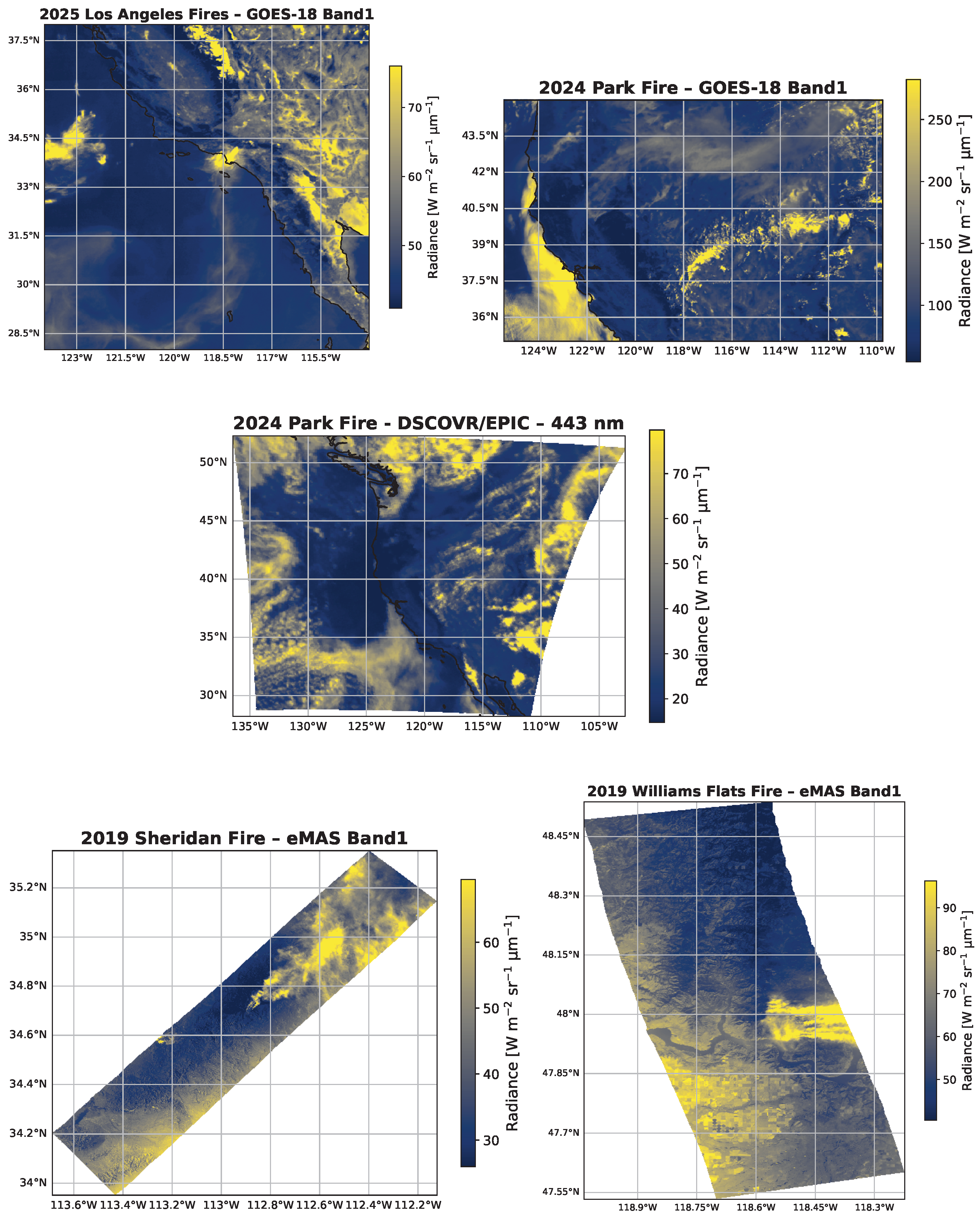
The datasets used to analyze the fire events in our study are summarized in Table 1. Corresponding geographic domains for these datasets are illustrated in Figure 1. The five datasets, which correspond to four major fire events, are as follows:
- The 2025 Los Angeles Fires (Eaton and Palisades) dataset was acquired by the Geostationary Operational Environmental Satellite (GOES) over Southern California on 9 January 2025, between 16:01 and 21:26 UTC. It consists of 66 images, each with a spatial resolution of 2000 m, a temporal resolution of 5 min, and a frame size of 556 × 556 pixels. The smoke plume associated with this event extended well beyond the immediate fire area, spread across much of Southern California, and was characterized by coherent and region-wide motion patterns. These broad and drifting smoke structures provide a valuable test case for evaluating optical flow performance on large-scale and diffuse plumes.
- The 2024 Park Fire dataset was acquired by the GOES satellite over Northern California between 25 July 2024, 14:08 UTC and 31 July 2024, 23:58 UTC (excluding the 15:00 UTC hour). It consists of 711 images, each with a spatial resolution of 2000 m, a temporal resolution of 5 min, and a frame size of 556 × 873 pixels. The smoke plume extended significantly across the region, which enabled long duration tracking of its transport and dispersion.
- A complementary 2024 Park Fire dataset was acquired by the EPIC instrument aboard the DSCOVR spacecraft over Northern California on 25 July 2024, between 20:52 and 21:57 UTC. It consists of 2 images, each with a spatial resolution of 8652 m, a temporal separation of approximately 65 min, and a frame size of 300 × 300 pixels. This dataset is coarser in space and time than GOES, and it provides an additional test case for evaluating optical flow performance under lower temporal resolution and coarse global-view conditions.
- The 2019 Sheridan Fire dataset was acquired by NASA’s eMAS over northwestern Arizona near the Prescott National Forest, Yavapai County, between 16 August 2019, 23:13 UTC and 17 August 2019, 00:57 UTC. It consists of 7 images, each with a spatial resolution of 50 m, a temporal separation of approximately 17 min. This dataset has varying frame sizes depending on the flight segment and swath geometry. The dataset captures complex smoke structures with high spatial detail, including significant variations in plume thickness, dispersion direction, and interactions with underlying terrain. The airborne vantage point and multi-angle viewing geometry of eMAS provide a good opportunity to resolve fine-scale smoke features and to test motion-tracking algorithms under variable illumination and platform motion.
- The 2019 Williams Flats Fire dataset was acquired by NASA’s eMAS over northeastern Washington between 6 August 2019, 18:15 UTC and 8 August 2019, 18:06 UTC. It consists of 6 images, each with a spatial resolution of 50 m. The dataset has irregular temporal sampling with varying time intervals between overpasses, as well as varying frame sizes, which reflect changes in aircraft track and viewing geometry between flight segments. This dataset captures the evolving smoke plume over multiple days, which is characterized by significant spatial extent and structural variability. As with Sheridan, the airborne vantage point and high spatial resolution provide detailed views of plume structure. The irregular temporal sampling and changing viewing geometry make Williams Flats a complementary and challenging test case for evaluating the robustness of smoke motion-tracking algorithms under nonuniform observational conditions.
The imagery was used to compute high-resolution smoke motion vectors via optical flow, which formed key test cases for validating our motion-tracking methodology.
Table 1.
Description of Analyzed Datasets.
Figure 1.
Geographic domains for the datasets described in Table 1. Radiances are shown.
2.2. Methods
To provide a brief overview, the processing workflow used in this study is summarized as follows. First, radiance datasets are prepared, and smoke regions are identified using SIT-FUSE masks where available. Second, for airborne eMAS data, undefined pixels outside the swath are filled using fast-marching inpainting after reprojection to a common grid. Third, dense TV–L1 optical flow is applied to each image pair to retrieve smoke motion vectors. Finally, performance is assessed using RMSE before and after warping and, for the GOES Park Fire case, by comparing retrieved vectors with collocated HRRR winds using the root mean square vector difference (RMSVD).
2.2.1. SIT-FUSE Masks
For each dataset, an accompanying set of smoke plume masks was generated using the Segmentation, Instance Tracking, and data Fusion Using multi-SEnsor imagery (SIT-FUSE) segmentation framework [21,22]. SIT-FUSE is a self-supervised learning framework that applies representation learning and hierarchical deep clustering to uncover the underlying structure of input imagery and associated geophysical object instances without the need for labeled training data. A limited number of human-labeled examples can subsequently be leveraged to associate specific output clusters with particular object types, such as smoke or active fire regions, in remote sensing imagery. Leveraging radiance data from the FIREX-AQ campaign as well as other spatiotemporal datasets, SIT-FUSE has undergone extensive quantitative and qualitative evaluation, including comparisons with expert-curated fire front and smoke plume annotations and direct analytical assessments [20,21,25]. A key strength of the SIT-FUSE framework is its sensor-agnostic design; it can be applied to multiple instruments and detect smoke plumes in both single- and multi-sensor fused datasets. This versatility makes it especially valuable in contexts with sparse labeled training samples.
The generated masks enable objective spatial delineation of smoke-affected regions over time, providing critical support for localized motion vector evaluation, difference imaging, and statistical analysis. By integrating SIT-FUSE segmentation, smoke-affected regions can be consistently and automatically targeted while excluding confounding background elements such as terrain, clouds, and clear skies. This targeted spatial filtering improves both the interpretability and statistical reliability of downstream motion and radiometric analyses. This ensures that derived optical flow fields reflect true plume motion rather than spurious background variation.
2.2.2. Inpainting of Missing Data
Airborne eMAS imagery contains regions with undefined radiance values outside the instrument swath. These regions with missing data produce irregular masks within the image domain. If not properly handling these regions, they can negatively affect the variational optical flow estimation by introducing artificial gradients or numerical artifacts near the swath boundaries. Similar issues can arise in other remote sensing datasets with internal gaps or cloud masks that remove large contiguous regions.
To obtain radiance fields that are suitable for optical flow computation and at the same time preserving the original signal where data are available, we apply a fast-marching inpainting method [26,27]. In this approach, missing pixels are filled by propagating information from the boundary of the region with valid data into the surrounding areas with undefined data. The algorithm determines a filling order for unknown pixels using a fast marching scheme and assigns values based on a weighted average of nearby known pixels, with weights that depend on distance and local gradient orientation. This construction allows the inpainted values to follow the surrounding intensity structure and to smoothly extend radiance patterns into the gaps.
In the Sheridan and Williams Flats eMAS cases, we first reproject the second image of each pair onto the grid of the first, initialize missing pixels using the median of valid radiances, and then apply the fast marching inpainting to fill regions with undefined data outside the swath before computing optical flow. It is important to note that inpainting is used only as a preprocessing step to provide well-defined inputs for the variational optical flow solver. All performance metrics (e.g., RMSE and RMSVD) are subsequently evaluated over quality-control masks that restrict the analysis to pixels with originally valid radiance and, where applicable, to smoke regions identified by SIT-FUSE.
2.2.3. Optical Flow Methodology
Optical flow refers to the apparent motion of image intensity patterns between two consecutive frames. In this work, we use a variational dense optical flow algorithm to estimate a two-dimensional displacement field that maps each pixel in the first image to its corresponding location in the second image. The method assumes approximate brightness constancy between frames and uses regularization to enforce spatial coherence of the motion field.
We employ the TV–L1 optical flow formulation [27,28,29,30], in which the displacement field is obtained by minimizing an energy functional of the form
where and are the radiance (or reflectance) fields at two times. The first term in the functional measures the L1 discrepancy between the warped second image and the first image, and is the total variation of the vector field [31]. The L1 data term [32,33] provides robustness to noise, illumination changes, and shifts from strict brightness constancy, while TV regularization preserves sharp gradients and discontinuities in the motion field, such as plume edges, without oversmoothing fine structures. The minimization is carried out using a coarse–to–fine warping strategy with iterative updates of the flow field.
The algorithm produces a dense motion vector at every pixel in the domain, including regions where traditional feature tracking methods provide few or no reliable vectors. In previous work, the optical flow methodology was systematically evaluated for Atmospheric Motion Vector (AMV) retrieval from water vapor imagery using high-resolution numerical simulations across multiple weather regimes and time intervals [19]. In that study, it consistently outperformed the pattern matching algorithm described in [16] and showed reduced sensitivity to temporal separation between images. The results also demonstrated that the optical flow-derived AMVs closely resemble simulated winds.
In the present study, we apply this TV–L1 optical flow framework to radiance imagery from geostationary (GOES), airborne (eMAS), and deep-space (DSCOVR/EPIC) sensors to retrieve dense smoke plume motion vectors. For GOES cases, the algorithm is applied directly to the 0.47 μm “Blue” band images. For DSCOVR/EPIC, we use the 0.443 μm blue channel and map both images to a common grid prior to flow estimation. For airborne eMAS scenes, we use the 0.465 μm blue channel; missing data outside the swath are first filled using inpainting, and all images are then mapped to a common grid prior to flow estimation. The resulting motion fields are then analyzed within SIT-FUSE smoke masks (where available) and over the full scene to assess smoke-specific and global alignment performance.
2.2.4. RMSE-Based Evaluation
To quantify the effect of optical flow-based motion correction, we evaluated the RMSE between image pairs before and after warping. For a given image pair p with images and , the RMSE over a set of valid pixels (e.g., a global quality-control mask or a smoke-region mask) is defined as
For the entire dataset, consisting of P image pairs, the mean RMSE is defined as
After estimating the optical flow between the two images, we warped the second image using the retrieved motion field and recomputed the RMSE relative to the first image. The difference between the pre-warp and post-warp RMSE values provides a quantitative measure of how much the motion correction improves pixel-level alignment between the two frames.
RMSE was evaluated over two types of masks where available: (i) a global quality-control mask, and (ii) a smoke-region mask which is derived from SIT-FUSE labels and further restricted by the quality-control conditions. The quality-control mask excluded pixels with invalid radiances and pixels with unrealistically large retrieved speeds exceeding 100 m s−1. This threshold was chosen as a conservative upper bound that is well above typical horizontal wildfire-smoke transport speeds and is intended only to remove obvious retrieval outliers associated with poor local correspondence, image artifacts, or swath-boundary effects. For each dataset, all image pairs listed in Table 1 were included in the RMSE analysis. Because the TV–L1 optical flow formulation is designed to reduce radiance mismatch between successive images, RMSE before and after warping provides an internally consistent diagnostic of motion-compensation performance and image alignment [28,29,30]. We emphasize, however, that RMSE reduction alone does not constitute independent physical validation of the retrieved smoke motion vectors. Rather, it quantifies how effectively the retrieved motion field explains the observed frame-to-frame radiance displacement.
2.2.5. Comparison with HRRR Winds
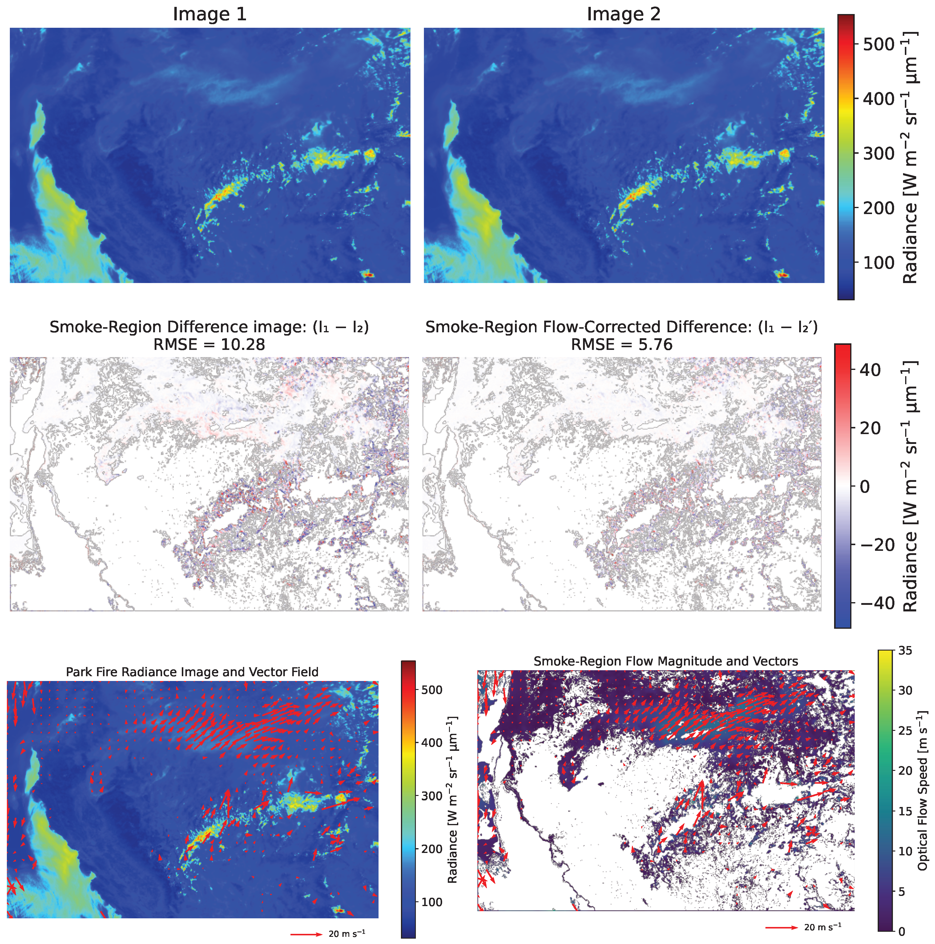
To provide an initial physical interpretation of the retrieved smoke motion vectors, we compared the optical flow results for the 2024 Park Fire GOES case with collocated winds from the HRRR model [23,24]. HRRR is an hourly-updating, convection-allowing numerical weather prediction system that provides three-dimensional wind fields over the continental United States. For this comparison, we used 10 consecutive GOES image pairs spanning 18:36 to 19:26 UTC on 26 July 2024, beginning with the same GOES image pair displayed in Figure 2. Because HRRR output is hourly, all ten GOES pairs were compared with the nearest available HRRR analysis time at 19:00 UTC.
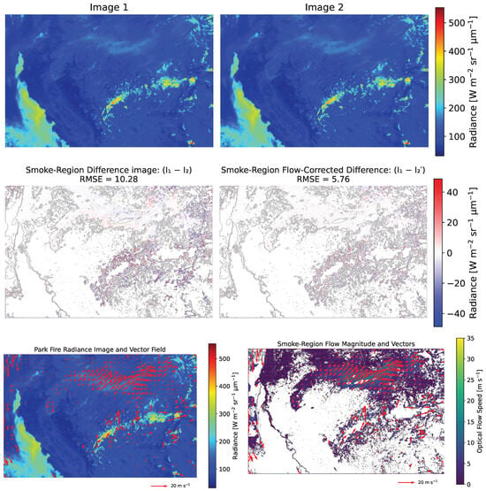
Figure 2.
(Top row) GOES satellite images of the 2024 Park Fire, acquired 5 min apart at 18:36 and 18:41 UTC on 26 July 2024. (Middle row) (Left) Raw difference image over the smoke region. (Right) Difference image after optical flow correction, showing improved alignment of smoke features. (Bottom row) (Left) Radiance image overlaid with optical flow–derived smoke motion vectors. (Right) Magnitude of smoke motion overlaid with the same motion vectors.
HRRR wind components were extracted at all available pressure levels and interpolated horizontally onto the optical flow grid. Specifically, the HRRR u- and v-wind fields were cropped to the optical-flow domain, then interpolated to the GOES latitude/longitude. The comparison was restricted to pixels satisfying the same optical flow quality-control conditions that were used in the GOES analysis.
For each pressure level and for each GOES pair in the analyzed subset, we computed the RMSVD between the optical flow smoke motion vectors and the collocated HRRR winds :
where denotes the set of valid comparison pixels. The RMSVD profiles were then averaged across the 10 consecutive GOES pairs, and the pressure level with the minimum mean RMSVD was identified as the level whose HRRR winds most closely matched the retrieved smoke motion vectors for this case. The variability across pairs was summarized using the standard deviation at each pressure level.
3. Results
Optical-flow performance was evaluated using the RMSE metric defined in Section 2.2.4, computed over both global and smoke-only masks where available. For the Park Fire GOES case, we additionally evaluated the consistency of the retrieved smoke motion vectors with collocated HRRR winds using the RMSVD metric defined in Section 2.2.5. For each dataset, all image pairs listed in Table 1 were included in the RMSE analysis. Table 2 summarizes the mean global and smoke-region RMSE values before and after optical-flow-based motion correction for all datasets.
Table 2.
Summary of mean RMSE values before and after optical-flow-based motion correction. Smoke-region RMSE is unavailable for the DSCOVR/EPIC case because SIT-FUSE smoke masks were not available.
3.1. Satellite Retrieval of Wildfire Smoke Motion
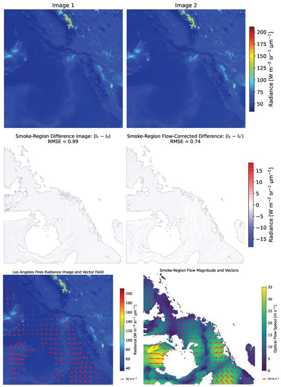
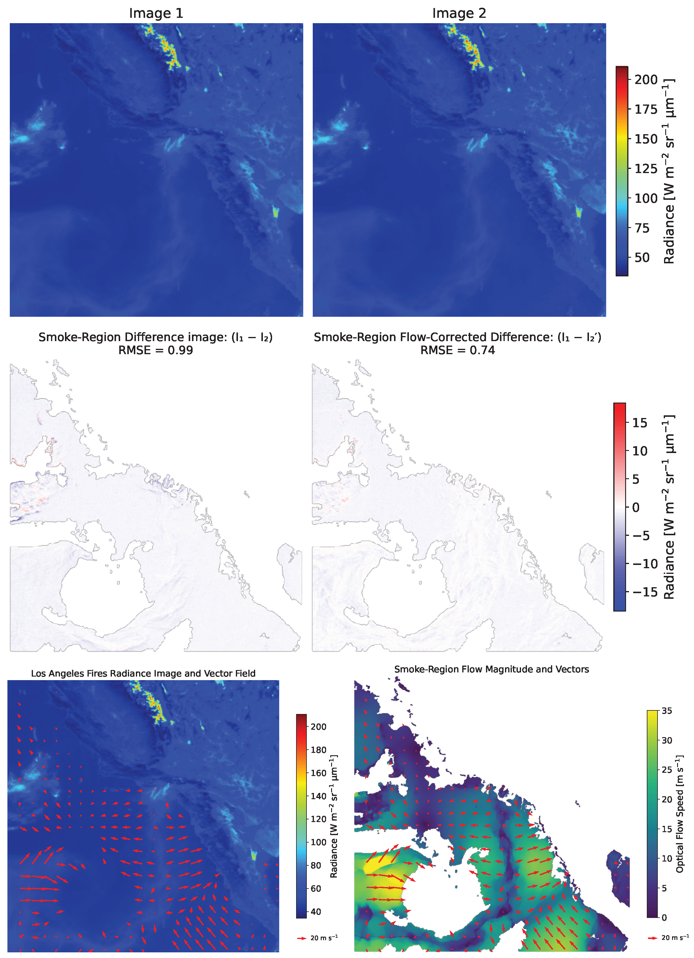
For the 2025 Los Angeles Fires (Eaton and Palisades), the high temporal resolution (5-min intervals) allowed for detailed tracking of the evolving smoke plumes. We evaluated both the global RMSE over the full scene and the smoke-only RMSE, where the error was computed only within smoke regions identified using the SIT-FUSE labels. Optical flow reduced the mean global RMSE from 1.437 to 1.133 and the mean RMSE over smoke regions from 1.994 to 1.078. This demonstrated significantly improved spatial alignment of the smoke plume structures after motion correction. Figure 3 illustrates these results: the top row shows two GOES radiance images acquired 5 min apart; the middle row shows the smoke-region difference images before (left) and after (right) optical flow correction; and the bottom row shows, on the left, the radiance field overlaid with smoke-motion vectors and, on the right, the corresponding smoke-motion magnitude overlaid with the same vectors. Together, these panels show the RMSE reduction and the corresponding improvement in frame-to-frame plume alignment after motion correction.
Figure 3.
(Top row) Two images from the Geostationary Operational Environmental Satellites (GOES), showing the 2025 Los Angeles Fires, acquired 5 min apart at 17:21 and 17:26 UTC on 9 January 2025. (Middle row) (Left) Raw difference image over the smoke region. (Right) Difference image after optical flow correction, showing improved alignment of smoke features after motion correction. (Bottom row) (Left) Radiance image overlaid with optical flow–derived smoke motion vectors. (Right) Magnitude of smoke motion overlaid with the same motion vectors.
For the 2024 Park Fire (see Figure 2), the 5-min GOES imagery over multiple days provided a long and high-temporal-resolution record of plume evolution. We assessed both the global RMSE over the full scene and the smoke-only RMSE, where the error was computed exclusively within smoke regions identified using the SIT-FUSE labels. Optical flow reduced the mean global RMSE from 17.036 to 7.646 and the mean RMSE over smoke regions from 13.047 to 6.653. Smoke-only difference images (Figure 2) show improved frame-to-frame alignment of plume structures after motion correction. Smoke plume vector plots overlaid on radiance images further illustrate the spatial variability in the retrieved plume motion.
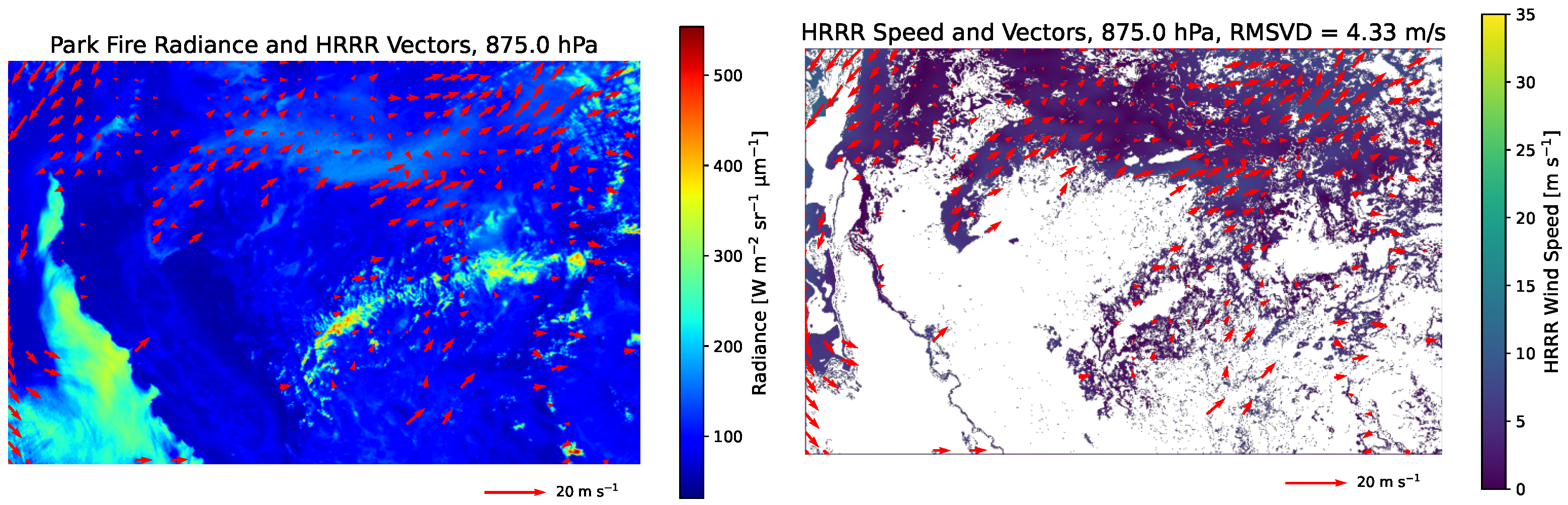
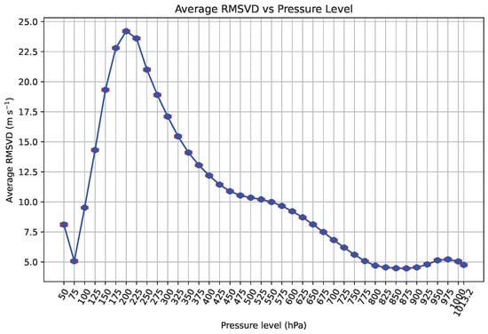
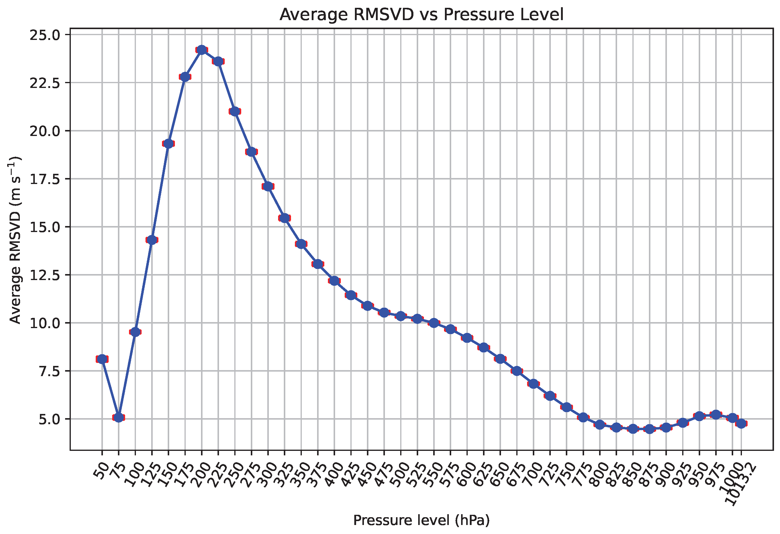
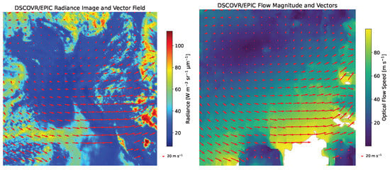
For the Park Fire case, we compared the retrieved smoke motion vectors with collocated HRRR winds using the procedure described in Section 2.2.5. We considered a selected subset of 10 consecutive GOES image pairs spanning 18:36 to 19:26 UTC on 26 July 2024, all referenced to the nearest HRRR analysis time at 19:00 UTC. Figure 4 shows the radiance field for the first GOES pair in the comparison sequence, overlaid with the HRRR vector field at the selected comparison level. The radiance field corresponds to the same GOES image pair shown in Figure 2, while the HRRR field is taken from the nearest available analysis time (19:00 UTC). To assess consistency across the subset, we computed the RMSVD between the optical flow motion vectors and HRRR winds at 40 pressure levels ranging from 50.0 to 1013.2 hPa for each of the 10 pairs and then averaged the resulting RMSVD profiles. The minimum mean RMSVD was 4.47 (±) 0.11 m s−1 at 875 hPa, with similarly low values over neighboring lower-tropospheric levels (Figure 5). Relatively small RMSVD values at some very low-pressure levels coincide with weak modeled winds, meaning that the vector difference can remain small even without a physically meaningful match to plume transport. For this reason, these levels are not interpreted as evidence that the smoke plume is moving at those altitudes. Instead, the broad minimum between 800 and 900 hPa provides the more physically plausible consistency range for this case.
Figure 4.
High-Resolution Rapid Refresh (HRRR) wind fields for the 2024 Park Fire case at 875 hPa, the pressure level yielding the lowest mean root mean square vector difference (RMSVD) across 10 consecutive GOES image pairs spanning 18:36 to 19:26 UTC on 26 July 2024. (Left) Park Fire radiance image overlaid with HRRR wind vectors at the 875 hPa pressure level interpolated to the optical flow grid. (Right) HRRR wind-speed magnitude and vectors at the same pressure level. The radiance field corresponds to the first GOES pair in the comparison sequence (18:36 and 18:41 UTC), and the nearest HRRR analysis time is 19:00 UTC.
Figure 5.
Mean RMSVD between optical flow smoke motion vectors and collocated HRRR winds for 10 consecutive GOES Park Fire image pairs spanning 18:36 to 19:26 UTC on 26 July 2024, plotted as a function of HRRR pressure level. Error bars in red denote (±1) standard deviation across the 10 pairs. A broad minimum occurs in the lower troposphere, with the smallest mean RMSVD at 875 hPa.
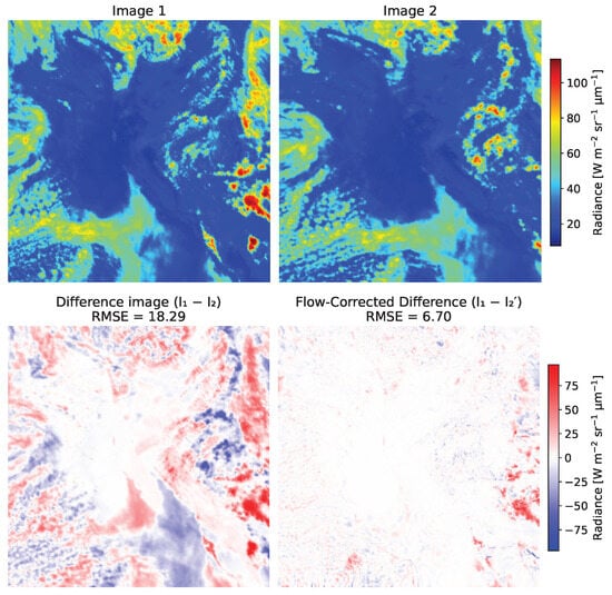
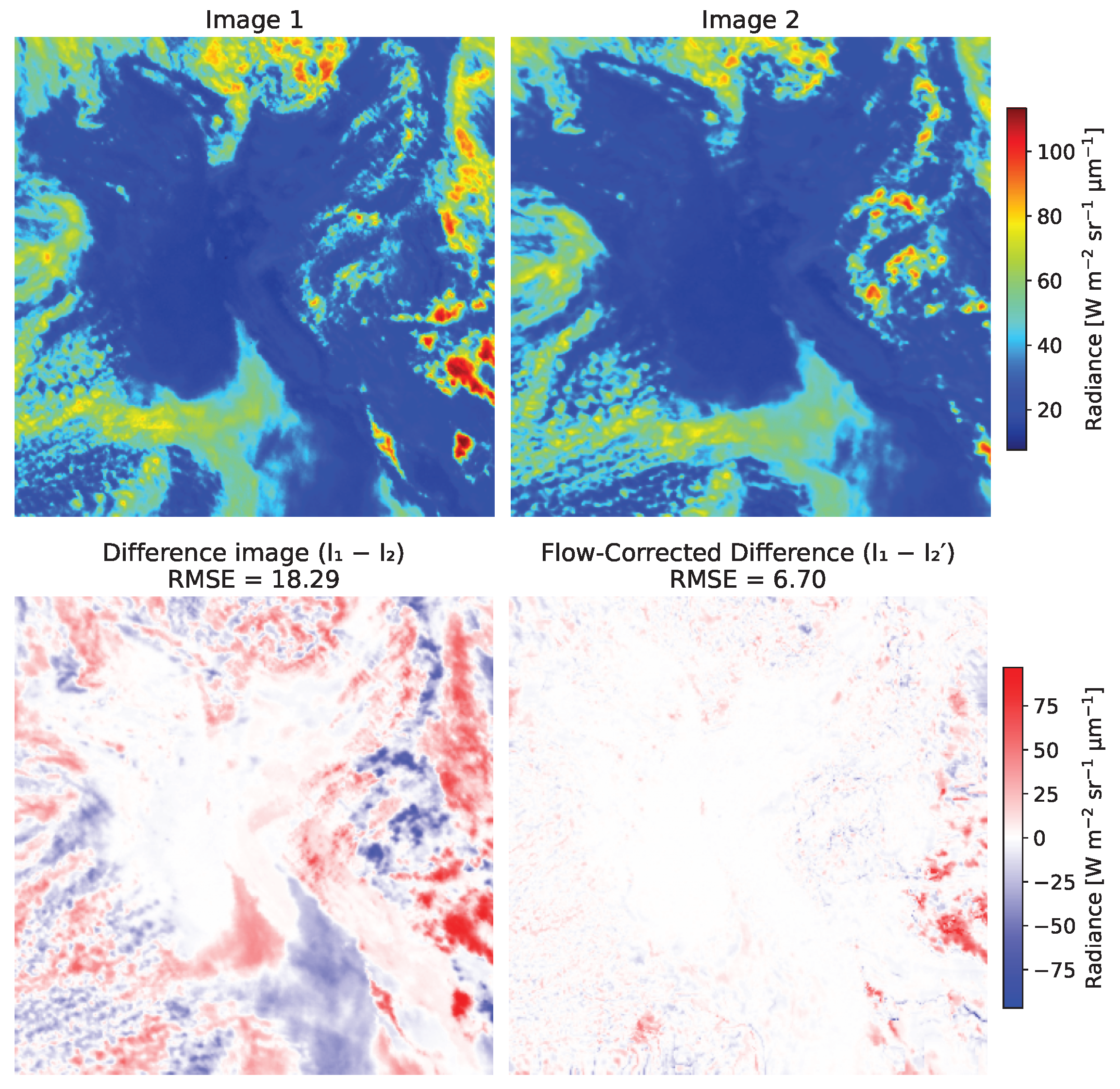
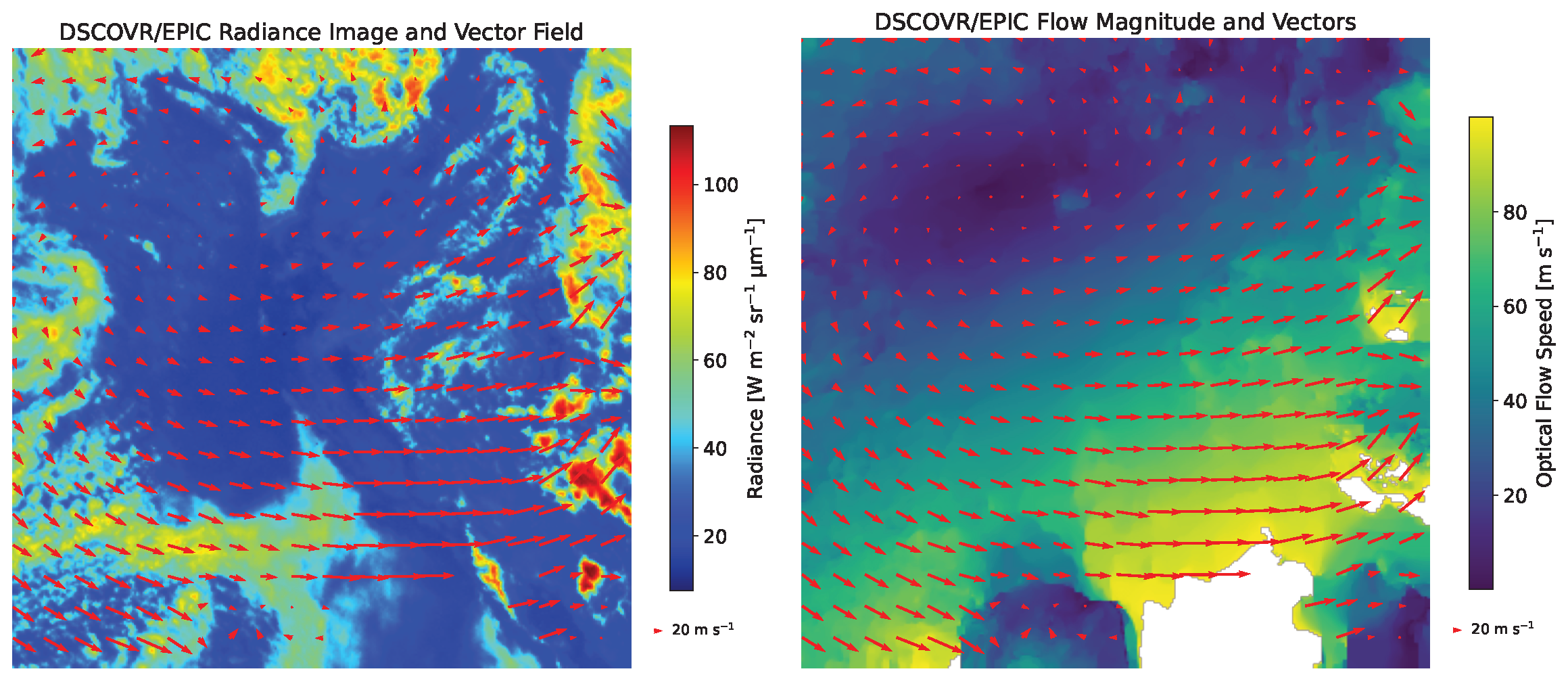
For the 2024 Park Fire, we also analyzed a complementary pair of DSCOVR/EPIC images acquired approximately 65 min apart (see Figure 6). Because SIT-FUSE smoke masks were unavailable for EPIC, we evaluated only the global RMSE across the full scene. Optical flow reduced the mean global RMSE from 18.29 to 6.70. Difference images and flow-magnitude fields (Figure 6) show improved alignment of large-scale plume-related structures after motion correction.
Figure 6.
(Top row) Images from the Earth Polychromatic Imaging Camera (EPIC) aboard the Deep Space Climate Observatory (DSCOVR), showing the 2024 Park Fire and acquired approximately 65 min apart at 20:52 and 21:57 UTC on 25 July 2024. (Middle row) (Left) Raw difference image. (Right) Difference image after optical flow correction, showing improved alignment of smoke features. (Bottom row) (Left) Radiance image overlaid with optical flow–derived motion vectors. (Right) Magnitude of smoke motion overlaid with the same motion vectors.
3.2. Airborne Retrieval of Wildfire Smoke Motion
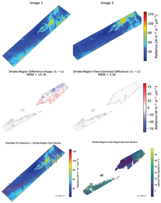
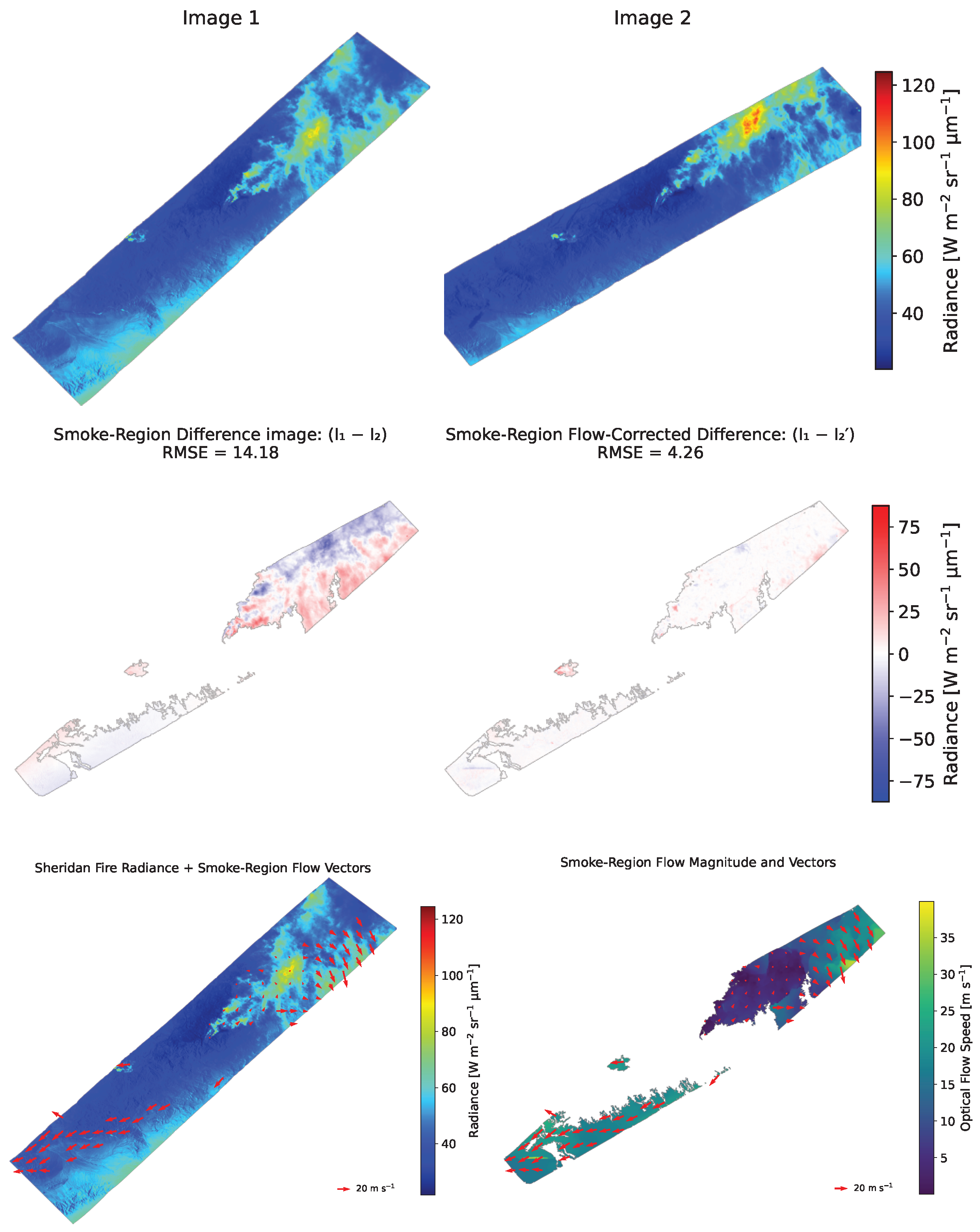
For the 2019 Sheridan Fire (see Figure 7), seven sequential high-resolution images from NASA’s eMAS were used to evaluate the method. The images were taken approximately 17 min apart. Optical flow was applied and evaluated using SIT-FUSE smoke labels to quantify region-specific alignment statistics. Because the airborne eMAS data contain undefined pixels away from the swaths, we first reprojected the second image onto the grid of the first image and applied a Fast Marching inpainting method [26,27] to fill missing pixels, using the median of valid radiances as an initialization. Optical flow was then computed on these inpainted radiance fields.
Figure 7.
(Top row) Two airborne images from NASA’s Enhanced MODIS Airborne Simulator (eMAS) of the 2019 Sheridan Fire, acquired 17 min apart at 00:06 and 00:23 UTC on 17 August 2019. The second image has been reprojected to spatially align with the first. (Middle row) (Left) Raw difference image over the overlapping region and smoke plume. (Right) Difference image after optical flow correction, showing improved alignment of smoke structures. (Bottom row) (Left) Radiance image overlaid with optical flow–derived smoke motion vectors. (Right) Magnitude of smoke motion overlaid with the same motion vectors.
To evaluate the performance of optical flow on the Sheridan fire case, we defined a global quality-control mask which consisted of pixels with valid radiance in both images and excluded those with unrealistically large retrieved speeds. We also defined a smoke-region mask given by the union of SIT-FUSE smoke labels at the two times intersected with the global quality-control mask. RMSE before and after warping was computed separately over these two masks. Optical flow reduced the mean global RMSE from 12.712 to 6.103 and the mean RMSE over smoke regions from 17.240 to 8.289. This corresponds to improved alignment of smoke plume structures after motion correction. As in the Los Angeles and Park Fire cases, Figure 7 includes raw and flow-corrected difference images over the smoke region, as well as radiance fields and motion-magnitude maps overlaid with smoke-motion vectors. These visualizations show reduced mismatch between frames after motion correction.
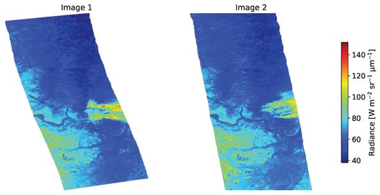
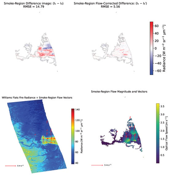
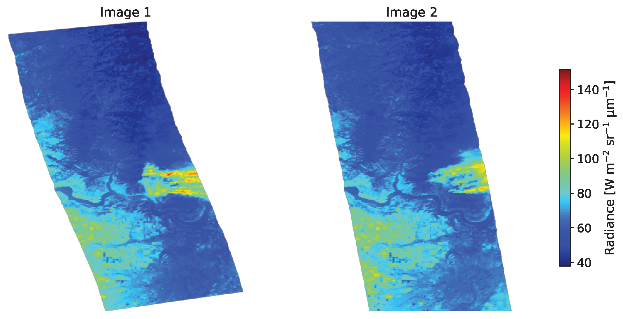
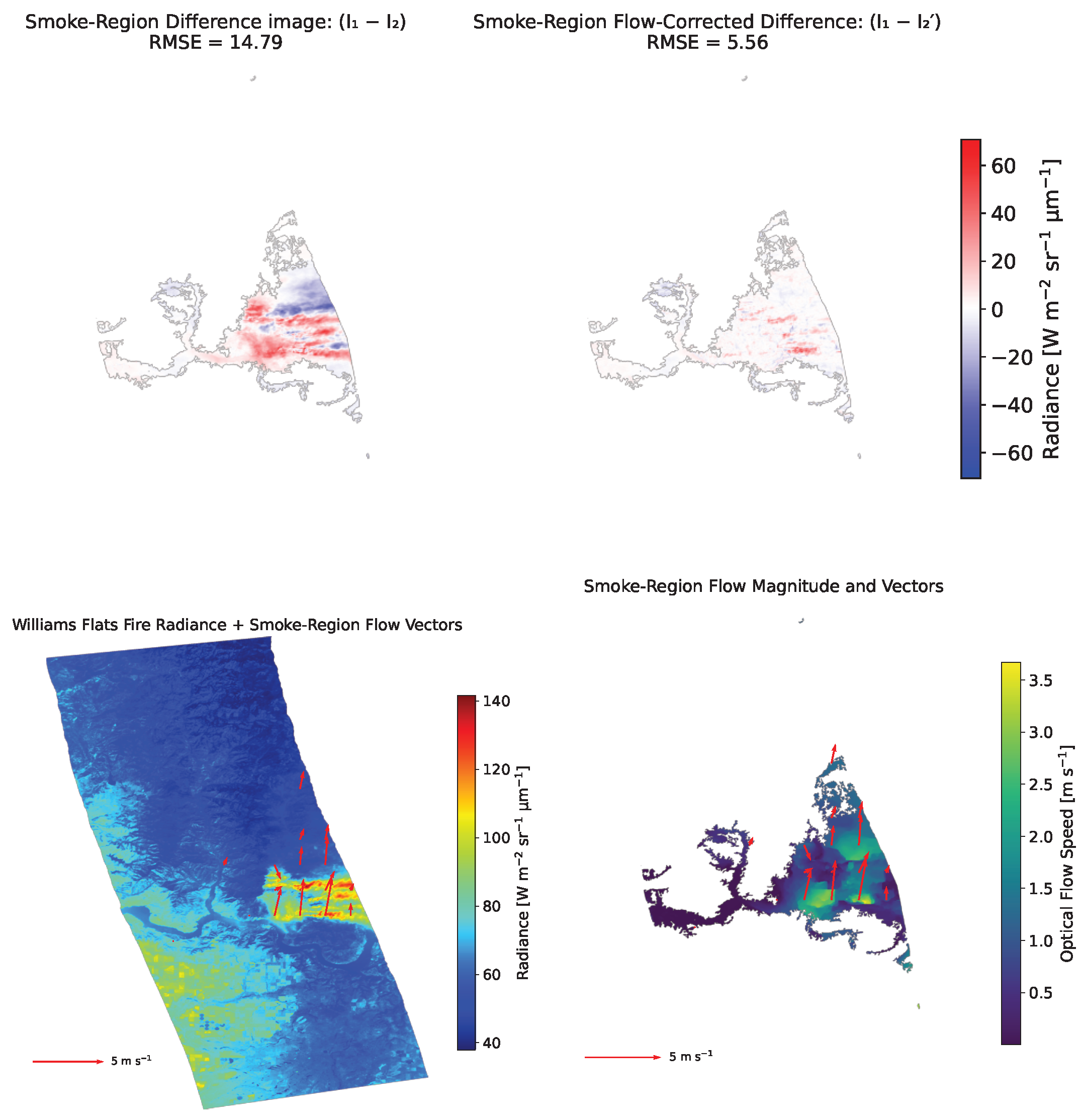
For the 2019 Williams Flats Fire (see Figure 8), six sequential high-resolution images from NASA’s eMAS were used to evaluate the method. The images were acquired with irregular temporal separations between overpasses. As in the Sheridan case, we reprojected the second image of each pair onto the grid of the first image, applied Fast Marching inpainting to fill undefined pixels away from the swaths, and computed optical flow on the resulting inpainted radiance fields. Performance was assessed using the same global quality-control and smoke-region masks defined from valid radiance and SIT-FUSE smoke labels. Optical flow reduced the mean global RMSE from 36.164 to 21.974 and the mean RMSE over smoke regions from 39.903 to 19.306. As in the Los Angeles, Park, and Sheridan Fire experiments, Figure 8 presents raw and flow-corrected difference images over the smoke region, as well as radiance fields and motion-magnitude maps overlaid with smoke-motion vectors. These figures show reduced mismatch after motion correction.
Figure 8.
(Top row) Two eMAS airborne images of the 2019 Williams Flats Fire, acquired 43 min apart at 18:15 and 18:58 UTC on 6 August 2019. The second image has been reprojected to spatially align with the first. (Middle row) (Left) Raw difference image over the overlapping region and smoke plume. (Right) Difference image after optical flow correction, showing improved alignment of smoke structures. (Bottom row) (Left) Radiance image overlaid with optical flow–derived smoke motion vectors. (Right) Magnitude of smoke motion overlaid with the same motion vectors.
4. Discussion
The results show that dense TV–L1 optical flow can retrieve smoke plume motion vectors from GOES, eMAS, and DSCOVR/EPIC imagery. Across all GOES and eMAS cases, the method reduced RMSE both globally and within SIT-FUSE smoke regions, with smoke-region RMSE decreasing by roughly a factor of two. These findings extend earlier work on AMV retrieval from simulated water-vapor imagery [19] by showing that the same variational framework can be applied directly to observed wildfire smoke radiance fields across multiple instruments and sampling regimes.
The individual test cases further illustrate the flexibility of the approach. GOES provided consistent performance in high-temporal-resolution satellite sequences, eMAS demonstrated that the method remains effective at much finer spatial resolution and under changing airborne viewing geometry, and DSCOVR/EPIC showed that useful large-scale smoke motion information can still be recovered from coarser global-view imagery. Together, these cases indicate that the method is applicable across a wide range of observing conditions, while the physical interpretation of the retrieved vectors depends on the observing geometry, the visible structure of the plume, and the time separation between images.
An important aspect of this study is the distinction between global and smoke-only metrics. Using SIT-FUSE masks to focus on smoke regions allows us to compute RMSE selectively over the plume, rather than averaging over background surface, cloud, and clear-sky areas that are not the primary target of the analysis. In several cases, smoke-only RMSE changes provide a clearer indication of plume alignment than global metrics, which average over large areas outside the plume and therefore mix behavior of smoke motion with that of the background scene. This underscores the value of combining segmentation-based approaches such as SIT-FUSE with optical flow, where segmentation identifies where smoke is present and optical flow describes how it moves. Restricting metrics to smoke masks also reduces the influence of non-smoke features that may have different radiative behavior or motion characteristics.
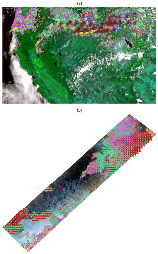
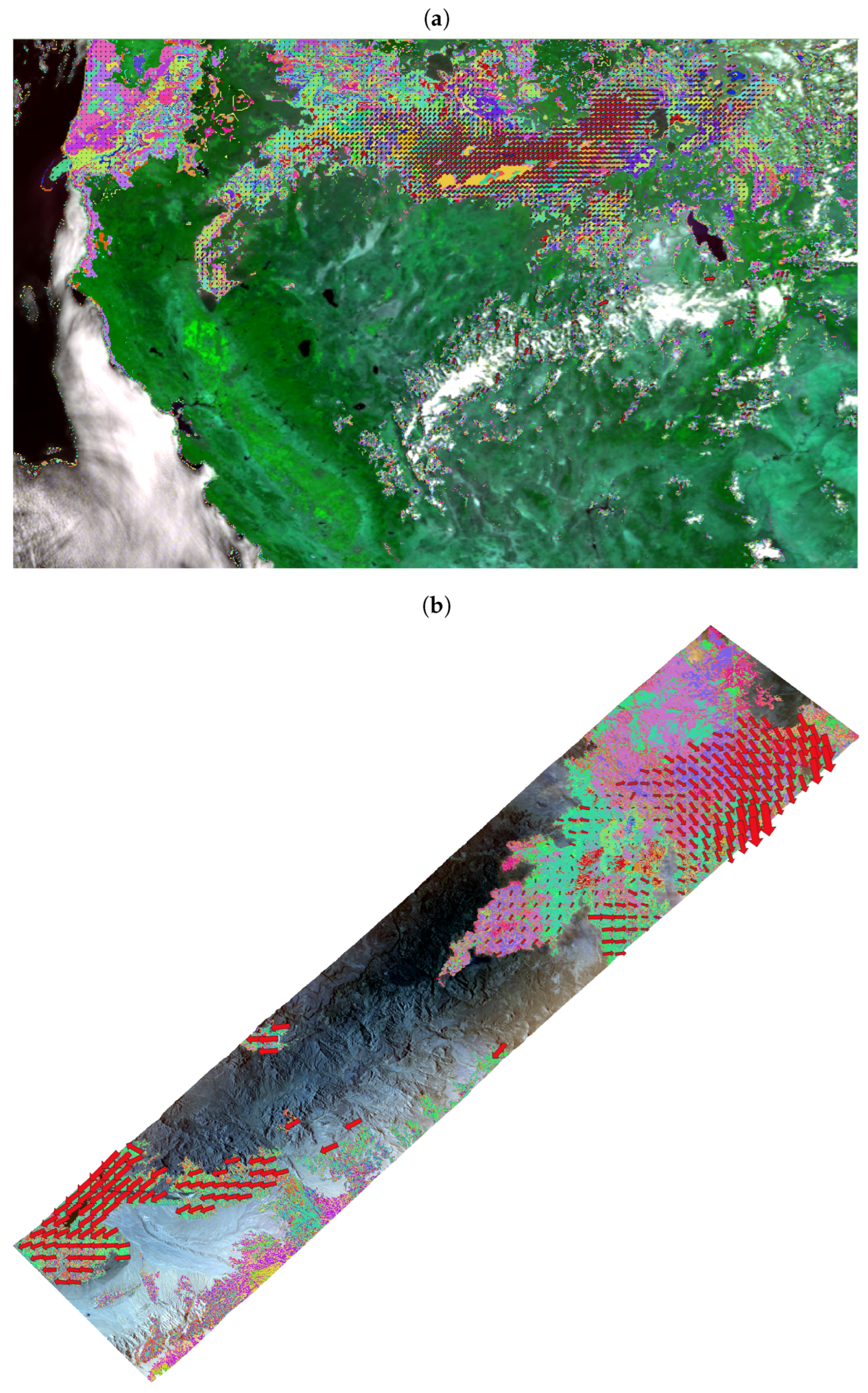
Figure 9 illustrates this combined use of SIT-FUSE and optical flow for two representative cases. In each example, the smoke mask provides the spatial distribution of segmented plume regions, while the overlaid optical flow vectors describe their local motion. This joint representation is useful not only for evaluating plume alignment within a scene, but also for supporting multi-scene and cross-sensor smoke tracking, where both spatial label structure and motion information can help determine whether a localized plume observed at a different time or by a different sensor corresponds to the same smoke feature.
Figure 9.
Integration of Segmentation, Instance Tracking, and data Fusion Using multi-SEnsor imagery (SIT-FUSE) smoke segmentation and optical-flow smoke motion vectors for multi-scene and cross-sensor smoke tracking. The figure shows multi-class smoke masks overlaid with smoke plume motion vectors for the GOES Park Fire scene (a) and the eMAS Sheridan Fire scene (b). Together, the smoke motion vectors and spatial label distributions provide information that can help determine whether a localized smoke plume observed in another scene or at another time corresponds to the same plume.
We note that RMSE reduction should be interpreted as an image-alignment metric rather than as independent validation of physical accuracy. Because the optical flow formulation is based on reducing radiance mismatch between frames, lower post-warp RMSE indicates that the retrieved motion field more effectively accounts for the observed image displacement [28,29,30]. However, wildfire smoke imagery is influenced not only by horizontal transport but also by plume growth, spreading and mixing, illumination changes, and departures from strict brightness constancy. For this reason, RMSE should be interpreted here as evidence of improved motion-compensated alignment and physically plausible smoke-motion retrieval, rather than as stand-alone proof that the retrieved vectors represent the surrounding wind at a single atmospheric level.
Related geometric limitations also affect physical interpretation. The retrieved vectors are inferred from two-dimensional, column-integrated radiance patterns and therefore reflect the apparent motion of the visible plume rather than a direct wind measurement at a single altitude. Variations in plume injection height, vertical wind shear, plume rise, and sensor viewing geometry can all modify the observed motion field. For GOES, elevated smoke layers can introduce plume-height-dependent apparent displacement relative to the surface projection, while for eMAS changing aircraft viewing geometry adds sensitivity near swath edges even after reprojection. Accordingly, the HRRR comparison is best viewed as a consistency check with the surrounding meteorological environment rather than a definitive plume-height retrieval or independent validation of the vectors [34].
Preprocessing choices play a significant role in airborne data. For the Sheridan and Williams Flats eMAS datasets, missing radiances outside the swath were filled using a fast marching inpainting method [26,27] after reprojection onto a common grid. This step is necessary to provide well-defined inputs to the variational optical flow solver and to avoid spurious gradients at swath boundaries. At the same time, all performance metrics were restricted to pixels with originally valid radiance and, where applicable, to SIT-FUSE smoke regions. This ensured that the evaluation reflects physical plume structures rather than inpainted areas. The success of the method in these high-resolution and irregularly sampled airborne cases suggests that similar preprocessing strategies could be applied to other instruments with partial coverage or internal gaps.
The comparison with collocated HRRR winds for the Park Fire case provides additional physical context for the retrieved smoke motion vectors. Across 10 consecutive GOES pairs, a broad minimum in mean RMSVD occurred between 800 and 900 hPa, with the lowest mean RMSVD at 875 hPa. This suggests that the retrieved smoke motion is most consistent, for this case, with lower-tropospheric flow. HRRR itself, however, carries uncertainties in wind structure, timing, and vertical representation, and its hourly sampling interval is coarser than the 5-min GOES imagery. In addition, relatively small RMSVD values at some very low-pressure levels are not interpreted physically, because the modeled winds there are weak and can produce artificially small vector differences. The HRRR comparison should therefore be regarded as an initial consistency check rather than independent validation, and additional comparisons with external datasets, plume-height information, and trajectory or dispersion products would provide a more comprehensive basis for evaluating the relationship between retrieved smoke motion and the surrounding meteorological environment.
These results also point naturally to several directions for future work. Closer integration with SIT-FUSE, beyond the use of static masks, would enable joint segmentation and automated instance tracking of smoke plumes and fire fronts, potentially supporting near-real-time monitoring applications and studies of long-range transport. Beyond comparison with model winds, the smoke motion vectors produced here could be used to initialize or evaluate Lagrangian smoke-dispersion calculations, diagnose sub-grid transport behavior in coupled fire-atmosphere simulations, and provide observational constraints for inverse emissions studies. In operational settings, near-real-time motion vectors could complement forecast systems by providing scene-specific guidance on plume advection for smoke hazard assessments and air-quality alerts. The same framework should also be transferable to additional sensors, such as VIIRS or Sentinel-3, provided that suitable spectral bands, geolocation accuracy, and temporal sampling are available. Similar adaptations may also be useful for tracking other transported atmospheric features, including volcanic ash and dust plumes.
5. Conclusions
This study evaluated a dense optical flow method for retrieving motion of wildfire smoke plumes from geostationary, deep-space, and airborne remote sensing imagery. Using five datasets covering four major fire events, we showed that applying optical flow to blue-band radiance fields systematically reduces RMSE between image pairs, both globally and within smoke regions identified by SIT-FUSE. In GOES and eMAS cases, smoke-region RMSE decreased by approximately a factor of two, which indicates a substantial improvement in alignment of plume structures after motion correction. Optical flow yielded a notable reduction in global RMSE even for the coarse-resolution widely separated DSCOVR/EPIC images.
The method proved effective across a range of spatial resolutions (from 50 m to several kilometers), temporal separations (from 5 min to roughly an hour), and scene characteristics. By combining optical flow with segmentation-based smoke masks, we were able to focus the evaluation on plume behavior and separate smoke-specific improvements from background effects. A comparison with collocated HRRR winds for 10 consecutive Park Fire pairs showed the closest agreement in a broad lower-tropospheric layer centered near 875 hPa, providing initial physical context rather than independent observational validation.
The resulting smoke motion vector fields provide a new observational resource for analyzing plume evolution and represent a step toward quantitative, multi-platform characterization of wildfire smoke transport. Future work will extend this analysis through additional comparisons with wind and trajectory products, uncertainty quantification, closer integration with segmentation and tracking frameworks such as SIT-FUSE, and application to operational plume and hazard-monitoring systems. In this context, dense optical flow offers a promising tool for translating radiance imagery into quantitative descriptions of smoke motion, with potential benefits for air quality applications, fire weather research, and operational wildfire response.
Author Contributions
Conceptualization, I.Y., N.L. and O.V.K.; methodology, I.Y., N.L. and D.J.P.; software, I.Y. and N.L.; validation, I.Y.; formal analysis, I.Y. and N.L.; investigation, I.Y., N.L. and O.V.K.; data curation, I.Y., N.L. and W.C.P.; writing—original draft, I.Y.; writing—review and editing, I.Y., N.L., O.V.K., D.J.P. and W.C.P.; visualization, I.Y. and N.L.; supervision, I.Y.; project administration, I.Y.; funding acquisition, I.Y., N.L. and O.V.K. All authors have read and agreed to the published version of the manuscript.
Funding
The research was carried out at the Jet Propulsion Laboratory, California Institute of Technology, under a contract with the National Aeronautics and Space Administration and funded through the internal Innovative Spontaneous Concepts program and NASA ROSES A.46 DSCOVR Science Team. ©2026. All rights reserved.
Data Availability Statement
The radiance datasets and associated smoke masks analyzed in this study are publicly available via Zenodo at https://doi.org/10.5281/zenodo.15428368 [25]. The smoke motion vector products derived in this work are publicly available via Zenodo at https://doi.org/10.5281/zenodo.19744076 [35].
Acknowledgments
The authors gratefully acknowledge Hugo Lee of the Jet Propulsion Laboratory for helpful discussions, and Michael J. Garay of the Aerospace Corporation for providing the DSCOVR/EPIC radiance data. We would like to express our sincere gratitude to the anonymous peer reviewers for their invaluable contributions to this paper. Their insightful comments and constructive suggestions have significantly enhanced the quality and clarity of our work. We deeply appreciate their expertise and the time they dedicated to reviewing our manuscript.
Conflicts of Interest
Author Nicholas LaHaye was employed by the company Spatial Informatics Group, LLC. The remaining authors declare that the research was conducted in the absence of any commercial or financial relationships that could be construed as a potential conflict of interest.
Abbreviations
The following abbreviations are used in this manuscript:
| AMV | Atmospheric Motion Vector |
| DSCOVR | Deep Space Climate Observatory |
| eMAS | Enhanced MODIS Airborne Simulator |
| EPIC | Earth Polychromatic Imaging Camera |
| GOES | Geostationary Operational Environmental Satellite |
| HRRR | High-Resolution Rapid Refresh |
| MODIS | Moderate Resolution Imaging Spectroradiometer |
| NASA | National Aeronautics and Space Administration |
| NOAA | National Oceanic and Atmospheric Administration |
| RMSE | root mean square error |
| RMSVD | root mean square vector difference |
| SIT-FUSE | Segmentation, Instance Tracking, and data Fusion Using multi-SEnsor imagery |
| TV | Total Variation |
| UTC | Coordinated Universal Time |
References
- Jaffe, D.A.; O’Neill, S.M.; Larkin, N.K.; Holder, A.L.; Peterson, D.L.; Halofsky, J.E.; Rappold, A.G. Wildfire and prescribed burning impacts on air quality in the United States. J. Air Waste Manag. Assoc. 2020, 70, 583–615. [Google Scholar] [CrossRef] [Scilit] [PubMed]
- National Oceanic and Atmospheric Administration, Chemical Sciences Laboratory. Unmasking the Complicated Chemistry of Wildfire Smoke: How Far Have Scientists Come? 2025. Available online: https://csl.noaa.gov/news/2025/429_0514.html (accessed on 12 April 2026).
- Burke, M.; Driscoll, A.; Heft-Neal, S.; Xue, J.; Burney, J.; Wara, M. The changing risk and burden of wildfire in the United States. Proc. Natl. Acad. Sci. USA 2021, 118, e2011048118. [Google Scholar] [CrossRef] [Scilit]
- Xu, R.; Ye, T.; Yue, X.; Yang, Z.; Yu, W.; Zhang, Y.; Bell, M.L.; Morawska, L.; Yu, P.; Zhang, Y.; et al. Global population exposure to landscape fire air pollution from 2000 to 2019. Nature 2023, 621, 521–529. [Google Scholar] [CrossRef] [Scilit]
- Black, C.; Tesfaigzi, Y.; Bassein, J.A.; Miller, L.A. Wildfire smoke exposure and human health: Significant gaps in research for a growing public health issue. Environ. Toxicol. Pharmacol. 2017, 55, 186–195. [Google Scholar] [CrossRef] [Scilit]
- Hung, W.T.; Lu, C.H.S.; Alessandrini, S.; Kumar, R.; Lin, C.A. The impacts of transported wildfire smoke aerosols on surface air quality in New York State: A multi-year study using machine learning. Atmos. Environ. 2021, 259, 118513. [Google Scholar] [CrossRef] [Scilit]
- Prichard, S.; Larkin, N.S.; Ottmar, R.; French, N.H.; Baker, K.; Brown, T.; Clements, C.; Dickinson, M.; Hudak, A.; Kochanski, A.; et al. The fire and smoke model evaluation experiment—a plan for integrated, large fire–atmosphere field campaigns. Atmosphere 2019, 10, 66. [Google Scholar] [CrossRef] [Scilit]
- Yao, J.; Brauer, M.; Henderson, S.B. Evaluation of a wildfire smoke forecasting system as a tool for public health protection. Environ. Health Perspect. 2013, 121, 1142. [Google Scholar] [CrossRef] [Scilit]
- Huff, A.K.; Kondragunta, S.; Zhang, H.; Laszlo, I.; Zhou, M.; Caicedo, V.; Delgado, R.; Levy, R. Tracking Smoke from a Prescribed Fire and Its Impacts on Local Air Quality Using Temporally Resolved GOES-16 ABI Aerosol Optical Depth (AOD). J. Atmos. Ocean. Technol. 2021, 38, 963–976. [Google Scholar] [CrossRef] [Scilit]
- Liu, Y.; Heilman, W.E.; Potter, B.E.; Clements, C.B.; Jackson, W.A.; French, N.H.; Goodrick, S.L.; Kochanski, A.K.; Larkin, N.K.; Lahm, P.W.; et al. Smoke plume dynamics. In Wildland Fire Smoke in the United States: A Scientific Assessment; Springer: Cham, Switzerland, 2022; pp. 83–119. [Google Scholar] [CrossRef] [Scilit]
- Wiggins, E.B.; Soja, A.J.; Gargulinski, E.; Halliday, H.S.; Pierce, R.B.; Schmidt, C.C.; Nowak, J.B.; DiGangi, J.P.; Diskin, G.S.; Katich, J.M.; et al. High Temporal Resolution Satellite Observations of Fire Radiative Power Reveal Link Between Fire Behavior and Aerosol and Gas Emissions. Geophys. Res. Lett. 2020, 47, e2020GL090707. [Google Scholar] [CrossRef] [Scilit]
- Ellis, T.A.; Myers, J.; Grant, P.; Platnick, S.; Guerin, D.C.; Fisher, J.; Song, K.; Kimchi, J.; Kilmer, L.; LaPorte, D.D.; et al. The NASA Enhanced MODIS Airborne Simulator. In Earth Observing Systems XVI; SPIE: Stockholm, Sweden, 2011; Volume 8153. [Google Scholar] [CrossRef] [Scilit]
- Marshak, A.; Herman, J.; Adam, S.; Karin, B.; Carn, S.; Cede, A.; Geogdzhayev, I.; Huang, D.; Huang, L.K.; Knyazikhin, Y.; et al. Earth Observations from DSCOVR EPIC Instrument. Bull. Am. Meteorol. Soc. 2018, 99, 1829–1850. [Google Scholar] [CrossRef] [Scilit]
- Yang, W.; Marshak, A.; Várnai, T.; Knyazikhin, Y. EPIC Spectral Observations of Variability in Earth’s Global Reflectance. Remote Sens. 2018, 10, 254. [Google Scholar] [CrossRef] [Scilit]
- Choi, M.; Lyapustin, A.; Schuster, G.L.; Go, S.; Wang, Y.; Korkin, S.; Kahn, R.; Reid, J.S.; Hyer, E.J.; Eck, T.F.; et al. Light-absorbing black carbon and brown carbon components of smoke aerosol from DSCOVR EPIC measurements over North America and central Africa. Atmos. Chem. Phys. 2024, 24, 10543–10565. [Google Scholar] [CrossRef] [Scilit]
- Posselt, D.J.; Wu, L.; Mueller, K.; Huang, L.; Irion, F.W.; Brown, S.; Su, H.; Santek, D.; Velden, C.S. Quantitative Assessment of State-Dependent Atmospheric Motion Vector Uncertainties. J. Appl. Meteorol. Climatol. 2019, 58, 2479–2495. [Google Scholar] [CrossRef] [Scilit]
- Mallia, D.V.; Kochanski, A.K.; Kelly, K.E.; Whitaker, R.; Xing, W.; Mitchell, L.E.; Jacques, A.; Farguell, A.; Mandel, J.; Gaillardon, P.E.; et al. Evaluating Wildfire Smoke Transport Within a Coupled Fire-Atmosphere Model Using a High-Density Observation Network for an Episodic Smoke Event Along Utah’s Wasatch Front. J. Geophys. Res. Atmos. 2020, 125, e2020JD032712. [Google Scholar] [CrossRef] [Scilit]
- Kumar, A.; Pierce, R.B.; Ahmadov, R.; Pereira, G.; Freitas, S.; Grell, G.; Schmidt, C.; Lenzen, A.; Schwarz, J.P.; Perring, A.E.; et al. Simulating wildfire emissions and plume rise using geostationary satellite fire radiative power measurements: A case study of the 2019 Williams Flats fire. Atmos. Chem. Phys. 2022, 22, 10195–10219. [Google Scholar] [CrossRef] [Scilit]
- Yanovsky, I.; Posselt, D.J.; Wu, L.; Hristova-Veleva, S. Quantifying Uncertainty in Atmospheric Winds Retrieved from Optical Flow: Dependence on Weather Regime. J. Appl. Meteorol. Climatol. 2024, 63, 1113–1135. [Google Scholar] [CrossRef] [Scilit]
- LaHaye, N.; Garay, M.J.; Bue, B.D.; El-Askary, H.; Linstead, E. A Quantitative Validation of Multi-Modal Image Fusion and Segmentation for Object Detection and Tracking. Remote Sens. 2021, 13, 2364. [Google Scholar] [CrossRef] [Scilit]
- LaHaye, N.; Easley, A.; Yun, K.; Lee, H.; Linstead, E.; Garay, M.J.; Kalashnikova, O.V. Development and Application of Self-Supervised Machine Learning for Smoke Plume and Active Fire Identification from the Fire Influence on Regional to Global Environments and Air Quality Datasets. Remote Sens. 2025, 17, 1267. [Google Scholar] [CrossRef] [Scilit]
- LaHaye, N.; Pan, X.; Mahmoud, H.; Munashinge, T.; Abad, G.G.; Wei, J.; Lee, H. Harnessing Self-Supervised Deep Learning and Geostationary Remote Sensing for Advancing Wildfire and Associated Air Quality Monitoring: Improved Smoke and Fire Front Masking using GOES and TEMPO Radiance Data. In Proceedings of the IGARSS 2025—2025 IEEE International Geoscience and Remote Sensing Symposium, Brisbane, Australia, 3–8 August 2025; pp. 6359–6363. [Google Scholar] [CrossRef] [Scilit]
- Dowell, D.C.; Alexander, C.R.; James, E.P.; Weygandt, S.S.; Benjamin, S.G.; Manikin, G.S.; Blake, B.T.; Brown, J.M.; Olson, J.B.; Hu, M.; et al. The High-Resolution Rapid Refresh (HRRR): An Hourly Updating Convection-Allowing Forecast Model. Part I: Motivation and System Description. Weather. Forecast. 2022, 37, 1371–1395. [Google Scholar] [CrossRef] [Scilit]
- James, E.P.; Alexander, C.R.; Dowell, D.C.; Weygandt, S.S.; Benjamin, S.G.; Manikin, G.S.; Brown, J.M.; Olson, J.B.; Hu, M.; Smirnova, T.G.; et al. The High-Resolution Rapid Refresh (HRRR): An Hourly Updating Convection-Allowing Forecast Model. Part II: Forecast Performance. Weather. Forecast. 2022, 37, 1397–1417. [Google Scholar] [CrossRef] [Scilit]
- Chen, Y.; LaHaye, N.; Choi, J.W.; Zhen, Z.; Davis, P.E.; Lee, H.; Parashar, M.; Gel, Y.R.; Zagvozdkin, A.; Garay, M.; et al. Fire-D: Analysis and ML-Ready NASA-Centric Remote Sensing of Wildfire and Smoke [Data Set]; Zenodo: Geneva, Switzerland, 2025. [Google Scholar] [CrossRef]
- Telea, A. An Image Inpainting Technique Based on the Fast Marching Method. J. Graph. Tools 2004, 9, 23–34. [Google Scholar] [CrossRef] [Scilit]
- van der Walt, S.; Schönberger, J.L.; Nunez-Iglesias, J.; Boulogne, F.; Warner, J.D.; Yager, N.; Gouillart, E.; Yu, T.; scikit-image contributors. scikit-image: Image processing in Python. PeerJ 2014, 2, e453. [Google Scholar] [CrossRef] [Scilit] [PubMed]
- Zach, C.; Pock, T.; Bischof, H. A Duality Based Approach for Realtime TV-L1 Optical Flow. In Pattern Recognition; Hamprecht, F.A., Schnörr, C., Jähne, B., Eds.; Springer: Berlin/Heidelberg, Germany, 2007; pp. 214–223. [Google Scholar] [CrossRef] [Scilit]
- Wedel, A.; Pock, T.; Zach, C.; Bischof, H.; Cremers, D. An Improved Algorithm for TV-L1 Optical Flow. In Statistical and Geometrical Approaches to Visual Motion Analysis; Cremers, D., Rosenhahn, B., Yuille, A.L., Schmidt, F.R., Eds.; Springer: Berlin/Heidelberg, Germany, 2009; pp. 23–45. [Google Scholar] [CrossRef] [Scilit]
- Pérez, J.S.; Meinhardt-Llopis, E.; Facciolo, G. TV-L1 optical flow estimation. Image Process. Line 2013, 2013, 137–150. [Google Scholar] [CrossRef] [Scilit]
- Rudin, L.I.; Osher, S.; Fatemi, E. Nonlinear total variation based noise removal algorithms. Phys. D Nonlinear Phenom. 1992, 60, 259–268. [Google Scholar] [CrossRef] [Scilit]
- Alliney, S. Digital filters as absolute norm regularizers. IEEE Trans. Signal Process. 1992, 40, 1548–1562. [Google Scholar] [CrossRef] [Scilit]
- Meyer, Y. Oscillating Patterns in Image Processing and Nonlinear Evolution Equations; American Mathematical Society: Providence, RI, USA, 2001. [Google Scholar]
- Huang, J.; Loría-Salazar, S.M.; Deng, M.; Lee, J.; Holmes, H.A. Assessment of smoke plume height products derived from multisource satellite observations using lidar-derived height metrics for wildfires in the western US. Atmos. Chem. Phys. 2024, 24, 3673–3698. [Google Scholar] [CrossRef] [Scilit]
- Yanovsky, I.; LaHaye, N.; Kalashnikova, O.; Posselt, D.; Porter, W. Multi-Platform Wildfire Smoke Radiance and Motion-Vector Datasets from GOES, DSCOVR/EPIC, and Airborne eMAS Imagery [Data set]; Zenodo: Geneva, Switzerland, 2026. [Google Scholar] [CrossRef]

Disclaimer/Publisher’s Note: The statements, opinions and data contained in all publications are solely those of the individual author(s) and contributor(s) and not of MDPI and/or the editor(s). MDPI and/or the editor(s) disclaim responsibility for any injury to people or property resulting from any ideas, methods, instructions or products referred to in the content. |
© 2026 by the authors. Licensee MDPI, Basel, Switzerland. This article is an open access article distributed under the terms and conditions of the Creative Commons Attribution (CC BY) license.