


Highlights
What are the main findings?
- A fully integrated coherent Doppler wind lidar (CDWL) system designed for compact unmanned aerial vehicles (UAVs) is presented and has been validated through comparative experiments.
- A wind retrieval algorithm for UAV-based sensing is proposed based on a self-compensating mechanism and HHO optimization, offering high sensitivity and low reliance on external data.
What are the implications of the main findings?
- The reported CDWL system establishes a reliable novel paradigm for UAV-based wind sensing, which has been scarcely documented in prior research.
- The proposed algorithm advances the autonomy and real-time capability of the CDWL, fulfilling the requirements of UAV-based wind measurement.
Abstract
With the rapid development of low-altitude UAVs, accurate wind detection is crucial for ensuring flight safety and enabling broader applications. To address this need, this paper introduces a highly integrated CDWL system specifically designed for compact UAV platforms. The system incorporates a self-compensating Harris Hawks Optimization (SC-HHO) retrieval algorithm, which is tailored to the high-dynamic flight environment and stringent payload constraints of UAVs. This algorithm enables real-time wind retrieval with low dependence on external reference data while effectively compensating for platform motion. The performance of the proposed system was validated through the comparative experiment and the UAV-borne experiment. In the comparative experiment, the CDWL showed correlation coefficients above 0.976 in horizontal wind speed and 0.987 in horizontal wind direction relative to a benchmark airborne CDWL system, with corresponding root-mean-square errors better than 0.395 m/s and 4.135°, respectively. During the UAV-borne experiment, the CDWL retrieved platform velocity using the self-compensating mechanism, achieving a standard deviation of 0.080 m/s relative to global navigation satellite system (GNSS) measurements, and successfully acquired wind field information. These results confirm that the developed system provides a viable and practical technical solution for UAV-based remote wind sensing.
1. Introduction
The application of unmanned aerial vehicles (UAVs, or drones) has become increasingly prevalent across diverse fields such as logistics delivery, agricultural plant protection, and urban management [1]. Small UAVs, in particular, hold substantial potential for enhancing productivity and fostering economic growth [2]. However, the low-altitude atmospheric environment, especially the airspace below 1000 m, is characterized by complex meteorological phenomena, including significant wind shear and turbulence. These conditions pose considerable challenges to UAV flight safety, path planning, and operational efficiency [3]. Conventional meteorological detection systems, such as meteorological towers and fixed weather stations, are often inadequate for providing the real-time, high-resolution wind field data required for low-altitude flight operations. This limitation stems primarily from their insufficient spatial resolution, high deployment costs, and lack of mobility. Therefore, there is a pressing need to address this technological gap through innovative measurement methodologies.
In this context, researchers have investigated various UAV-based wind detection techniques. For compact UAVs, which hold considerable developmental promise, current studies focus primarily on two approaches. The first involves equipping drones with lightweight, low-power in situ anemometry devices, such as ultrasonic anemometers [4,5], Pitot tubes [6,7], and pressure sensors [8]. A key limitation of these onboard systems is their narrow detection range. Additionally, rotor-induced turbulence can substantially degrade measurement accuracy. Some studies have therefore devoted effort to developing specialized correction algorithms to counteract the influence of such turbulence on in situ measurements [9]. A more direct mitigation strategy involves mounting sensors on extended structures attached to compact UAVs for comparative testing [10,11]. Nevertheless, these solutions remain constrained by the inherent drawback of in situ devices. They can only measure wind conditions at the UAV’s immediate location, resulting in relatively low efficiency for mapping regional wind fields. Furthermore, elongated mounting structures can significantly alter the UAV’s aerodynamic characteristics and impede its maneuverability in confined spaces. An alternative approach explored in other studies employs computational fluid dynamics simulations coupled with neural networks to model and predict large-scale wind field distributions, thereby circumventing the limitations of in situ measurement [12,13]. However, the accuracy of such predictions depends heavily on extensive prior data collection, demonstrates limited adaptability to varying scenarios, and requires substantial computational resources.
Consequently, developing a compact UAV-borne device capable of remote wind measurement represents a critical objective. Such a system would facilitate the efficient remote sensing of real-time wind fields, directly overcoming the limitations outlined above. Moreover, it could supply high-fidelity data to improve both the robustness across varied conditions and the predictive accuracy of numerical forecasting algorithms.
Coherent Doppler wind Lidar (CDWL) has become a pivotal technology for low-altitude wind field detection, owing to its high precision, real-time monitoring capability, and non-contact measurement principle [14]. By analyzing the Doppler frequency shift in light backscattered by atmospheric aerosol particles, CDWL can accurately retrieve three-dimensional wind velocity and direction. Nevertheless, conventional ground-based or airborne CDWL systems are typically bulky and heavy [15,16]. Although research on miniaturized CDWL is advancing, reports of their complete integration with small UAV platforms remain limited. For example, Vasiljević et al. mounted only the optical antenna of a ZXT2 CDWL onto a small UAV, connecting it to the main radar body via a long optical fiber, and performed comparative validation against a meteorological tower [17]. This study effectively highlighted the feasibility and potential of CDWL for UAV-based wind sensing. However, the configuration differed from a fully integrated, self-contained UAV-borne system. In another investigation, Wang et al. deployed a CDWL on an unmanned helicopter, acquiring valid wind profile data at a flight altitude of 1.2 km [18]. Similarly, other studies have reported CDWL installations on UAV operating above a 3 km altitude. Based on the technical specifications of the CDWL units employed, these systems exceeded 20 kg in weight, necessitating a UAV platform with a payload capacity far beyond that of typical small UAVs [19].
Building upon existing research to advance UAV-based wind measurement technology, this paper presents a miniaturized CDWL system designed for complete integration with small UAVs. The system reliably performs effective detection of three-dimensional wind profiles below the UAV during flight operations. Given that UAVs often undergo frequent attitude changes, which can distort wind measurements due to relative motion between the platform and atmospheric aerosols, motion compensation is essential. Traditional motion compensation algorithms for airborne CDWL rely on multiple inputs from integrated navigation systems, including attitude and velocity data. To address this constraint, this paper proposes a novel three-dimensional wind field retrieval algorithm for miniaturized UAV-borne CDWL that operates with greater data autonomy. A series of verification experiments was conducted to evaluate the performance of the proposed system, comparing its measurements with those from reference instruments to assess wind measurement accuracy. Finally, based on the experimental results, the study examines the data utility of the system and discusses its potential application scenarios.
2. Miniaturized UAV-Borne Coherent Doppler Wind Lidar System
2.1. System Description
Compared to instruments such as ultrasonic anemometers and wind cups, CDWL typically exhibit significantly larger size, weight, and power consumption (SWaP), which poses a challenge for integration onto compact UAVs. The core components influencing the SWaP performance of a CDWL system include the laser source, signal processing module, optical antenna, and scanning mechanism. Notably, the parameters of the laser and optical lenses also directly influence the detection performance of the CDWL.
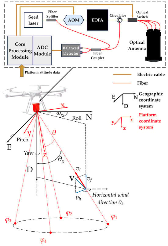
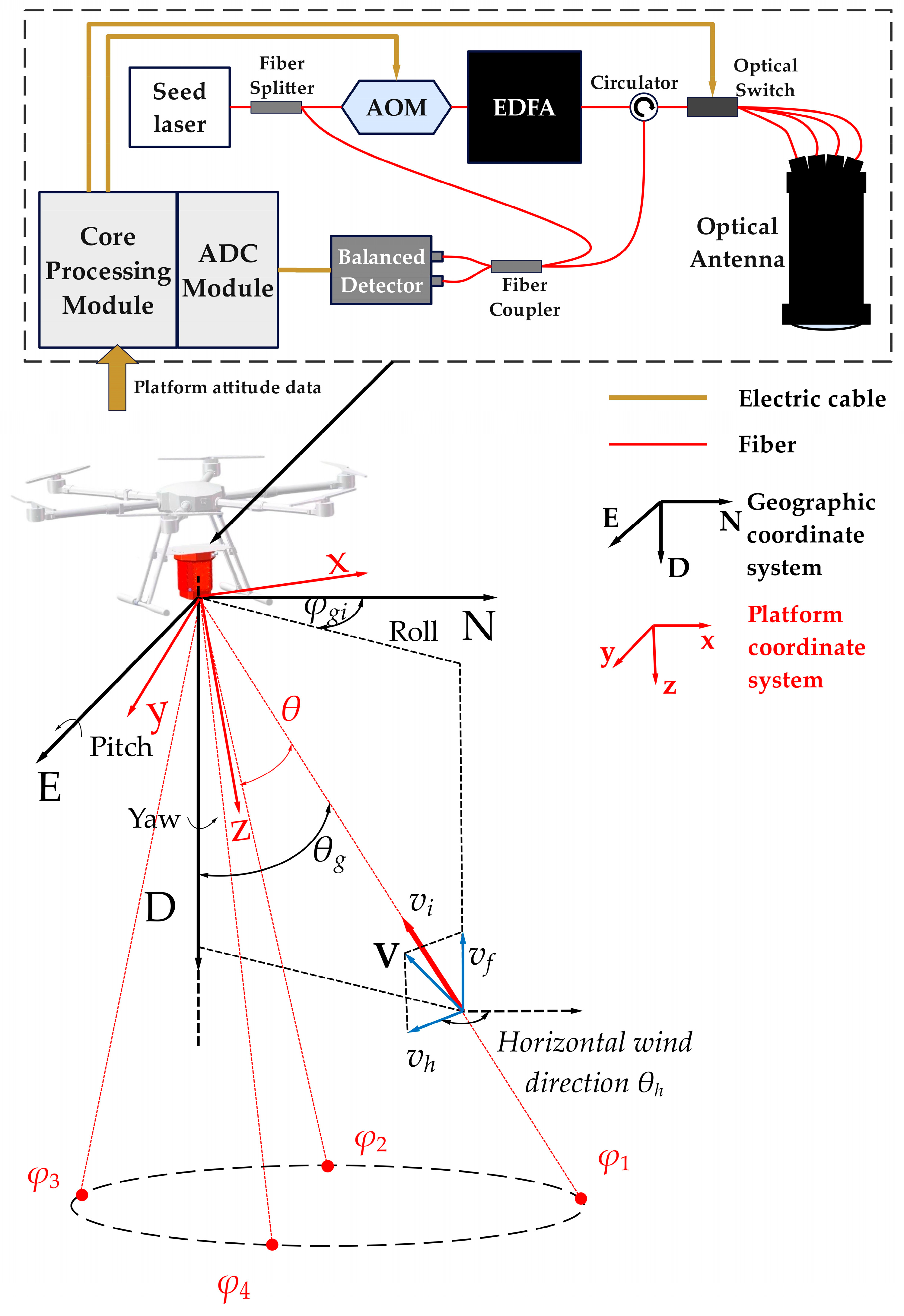
To meet the payload constraints of compact UAVs while considering their typical operational altitude, the Aerospace Information Research Institute, Chinese Academy of Sciences (AIRCAS) has designed and developed a miniaturized CDWL for UAV-borne applications, designated as CDWL-10H-4P. The system utilizes an all-fiber laser architecture operating at a wavelength of 1550 nm. A seed laser generates a single-frequency continuous-wave output with a linewidth of 5 kHz. This output is transmitted into a fiber splitter, which divides the beam into two paths with a power ratio of 9:1. The lower-power beam serves as the local laser (LO) for coherent detection. The higher-power beam is directed to an Acousto-Optic Modulator (AOM), where it undergoes a frequency shift of 120 MHz and is modulated into pulsed form. The pulsed laser is then amplified by an Erbium-Doped Fiber Amplifier (EDFA), achieving a typical output pulse energy of 10 μJ, a pulse width of 200 ns, and a pulse repetition frequency of 20 kHz. The CDWL-10H-4P system architecture and its onboard detection configuration are illustrated in Figure 1.
Figure 1.
The system layout and onboard detection configuration of the CDWL-10H-4P.
In conventional airborne CDWL systems, laser beam steering and scanning are typically accomplished using servo-controlled rotating wedge prisms [20,21,22]. This method introduces relatively complex servo-mechanical structures and associated electrical wiring. To reduce the complexity associated with such components, our system implements a more compact configuration that employs a fiber-optic switch paired with a multi-channel common-aperture optical antenna for laser channel selection [23]. The optical antenna is designed as a coaxial transceiver system with four fiber input channels. Each channel is oriented at a fixed 15° off-axis angle relative to the antenna’s central axis, and the four channels are arranged in azimuthally orthogonal pairs. For scanning measurements, a high-velocity optical switch selects the desired output fiber channel. This design offers extremely fast switching speeds and a long operational lifetime, providing significant advantages over traditional servo-mechanical scanners in terms of SWaP, scanning robustness, and pointing accuracy. The output laser pulses are guided through a fiber circulator to the optical switch. Upon receiving control commands, the switch directs the pulses to the corresponding channel of the optical antenna.
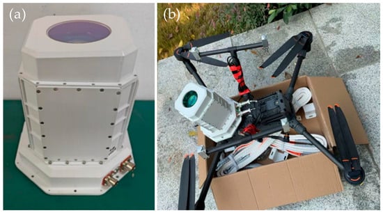
The antenna collimates and emits the laser pulses into the atmosphere. Backscattered light from aerosol particles is collected by the same antenna, coupled back into the receiving fiber, and routed through the circulator to a fiber coupler. Within the coupler, the backscattered signal coherently mixes with the LO. The resulting mixed optical signal is detected by a balanced photodetector and converted into a photocurrent. This electrical signal is then passed to the core processing module, where it undergoes analog-to-digital conversion, digital filtering, and Fast Fourier Transform (FFT) processing to generate raw spectrum data. Finally, the three-dimensional wind field information is retrieved by a dedicated wind retrieval algorithm implemented within the core processing module. An overview of the CDWL-10H-4P system is presented in Figure 2.
Figure 2.
An overview of the CDWL-10H-4P system: (a) Photograph of the CDWL-10H-4P; (b) an example of CDWL-10H-4P mounted on the DJI Matrice 400.
To ensure synchronized timing, the core processing module generates a time-synchronized TTL signal. This trigger signal initiates the laser pulse sequence, thereby synchronizing the entire data acquisition process. Compared to conventional aerial platforms, UAVs demonstrate more dynamic and complex motion. Mounting the CDWL on a UAV platform imposes higher demands on the real-time performance of its detection. Based on prior research experience, we consider that a data rate better than 1 Hz is sufficient for real-time detection, and a higher data rate further improves real-time capability. To enable responsive wind sensing, the number of non-coherent accumulations in the signal processing chain is typically set to 4000. This configuration yields a spectrum data rate of 5 Hz, while a higher rate can be achieved for specific application scenarios. Following the methodology established for traditional CDWLs [24,25], the motion compensation procedure requires importing platform motion data from external sensors. Consequently, information from an integrated navigation system (INS) must also be input into the core processing module. The core processing module subsequently transmits the generated multi-level data products to cloud storage via a network interface, making them available for user access. Based on the implementation of a lightweight integrated structure, the total weight of the complete wind lidar system is less than 4 kg. It operates on a 24 V direct-current (DC) power supply with a typical power consumption of 50 W, ensuring compatibility with common UAV power systems. Detailed system parameters are summarized in Table 1.
Table 1.
System parameters of CDWL-10H-4P.
To verify the performance of the miniaturized UAV-borne CDWL, validation experiments were carried out using a conventional helicopter and a UAV. The UAV-based experiments reported in this work were carried out with a quadcopter, DJI Matrice 400 (Shenzhen Dajiang Innovation Technology Co., Ltd., Shenzhen, China). This platform offers a maximum payload of 6 kg, a maximum working altitude of 7000 m, a maximum flight velocity of 25 m/s, and a maximum flight time of 59 min. Its detailed specifications are provided in Table 2. The CDWL-10H-4P was mounted securely onto the UAV using a custom adapter plate, with its optical window facing downward to enable detecting wind profiles. A rigid adapter structure was implemented to minimize relative motion and ensure stable mounting throughout the flight experiments.
Table 2.
System parameters of DJI Matrice 400.
2.2. Wind Retrieval Method Based on SC-HHO Algorithm
2.2.1. Algorithm Design
Wind retrieval algorithms for the CDWL generally can be classified into two categories. The first approach involves calculating the line-of-sight (LOS) wind velocity and combining it with the corresponding azimuth and elevation angles from multiple scans. The three-dimensional wind vector is subsequently derived by solving the geometric relationship between the LOS velocities and the wind components [26]. This method is advantageous for its computational speed and algorithmic simplicity. Its performance, however, depends critically on the accuracy and signal-to-noise ratio (SNR) of the LOS wind velocity calculation. Despite ongoing efforts to optimize these algorithms, substantial improvements for practical airborne deployment have yet to be realized [27,28].
The second approach directly retrieves the three-dimensional wind vector from the spectrum data acquired along different scanning directions [29]. This method provides distinct advantages in estimation accuracy and robustness under low-SNR conditions. The algorithms operate by searching for the wind vector within a predefined velocity space that maximizes a specific objective function, thereby providing an estimate that best approximates the true wind field. Since this problem lacks an analytical solution, a brute-force search for the optimal wind vector would entail prohibitive computational complexity, making real-time processing impractical. In existing research, optimization techniques such as Genetic Algorithms (GAs) [30], Simulated Annealing (SA) [31], and Particle Swarm Optimization (PSO) [32] have been employed to accelerate the calculation. While the fastest reported algorithms approach near-real-time performance, they still fall short of meeting the requirements for high maneuverability and the desired data rates in UAV-based wind sensing applications. The relationship between the LOS wind velocity and the wind vector can be expressed as:
Here, V represents the components of the wind vector along the three axes of the geographic coordinate system. According to Figure 1, φi is the azimuth angle of the i-th scanning channel, vi is the corresponding LOS wind velocity, and θ is the angle between the laser path and the CDWL’s central axis. On this basis, the horizontal wind speed Vh and the horizontal wind direction θh are the important meteorological parameters. The Vh is generally defined as the projection of the wind vector onto the horizontal plane, while the θh is defined as the angle between the horizontal wind velocity vector and north. The above parameters can be expressed as:
The above formula describes the basic principle of three-dimensional wind field retrieval, with the implicit assumption that angles such as wind direction θh, azimuth φi, and nadir angle θ are defined in the geographic coordinate system. In practical wind measurement scenarios where the CDWL is installed on a moving platform, the directly obtained angle information is expressed in the body coordinate system of the platform. Therefore, a coordinate transformation must be performed during wind field retrieval to correctly resolve the wind direction in the geographic coordinate system. For wind retrieval under such conditions, after transformation into the geographic coordinate system, the azimuth angle of the i-th scanning channel is denoted as φgi, and the angle between the laser scanning channel and the central axis of the lidar is denoted as θg. Based on the Doppler principle, the peak frequency in the measured spectrum for the i-th scanning channel can be described as a function, which is expressed as:
where λ is the laser wavelength, and fAOM is the frequency shift introduced by the AOM. vn, ve, and vu represent the platform velocity in the north, east, and up directions within the geographic coordinate system, respectively. An objective function E(V) is defined by accumulating the spectrum peak amplitudes from different scanning azimuth angles, which can be expressed as:
fi = 2/λ·[(vx + vn)·cosφgi·sinθg + (vy + ve)·sinφgi·sinθg + (vz + vu)·cosθg] + fAOM
In the equation, N denotes the number of azimuth angles, and S(fᵢ) signifies the spectrum amplitude at fᵢ corresponding to the i-th azimuth angle. In airborne wind measurement applications, Equation (3) indicates that compensation for the effects introduced by platform motion is essential during wind retrieval. Typically, a GNSS device or an inertial navigation system provides the platform’s motion velocity and attitude angles. The platform velocity is then projected onto the direction of the laser path for compensation. However, these exogenous motion data often exhibit certain deviations from the platform’s actual motion. Particularly during sudden changes in the platform’s motion state, such data can suffer from information lag, leading to compensation failure.
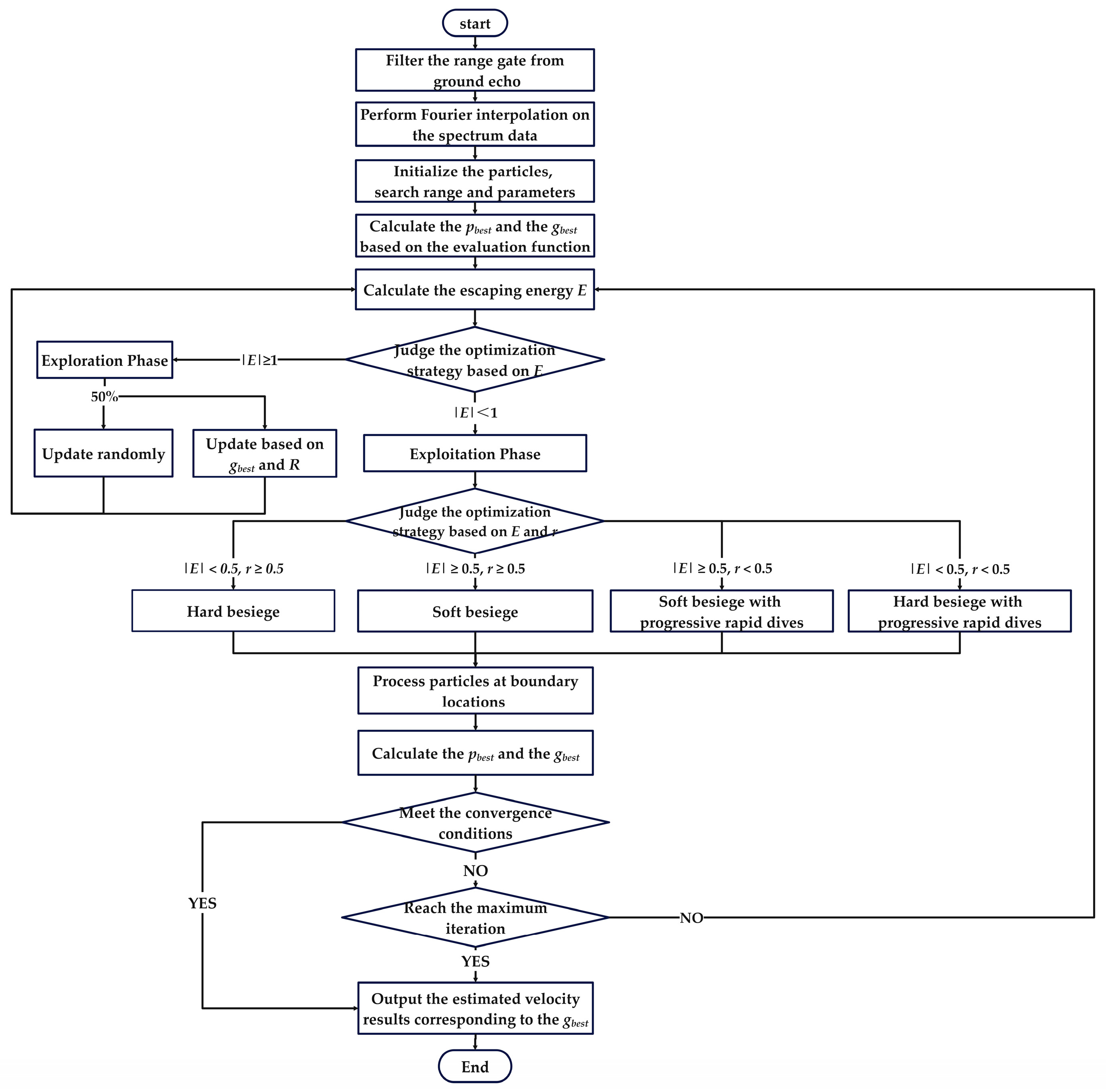
To address these limitations, this paper proposes a three-dimensional wind retrieval algorithm for UAV platforms that integrates a self-compensating (SC) mechanism with the HHO algorithm. Inspired by calibration experiments using stationary hard targets and a servo platter, the proposed algorithm leverages ground echoes acquired during airborne measurements as a precise reference for platform motion. Specifically, it extracts Doppler information arising from the relative motion between the platform and the stationary ground surface and applies this information to correct the wind measurement process, thereby achieving self-compensation.
The HHO algorithm is a novel meta-heuristic optimization algorithm based on swarm intelligence [33,34]. Its core workflow simulates the three-phase hunting behavior of Harris’ hawks: the exploration phase, the transition phase, and the exploitation phase. In the exploration phase, the algorithm mimics the hawks randomly perching and waiting to discover prey, employing two distinct strategies for global search. The transition phase dynamically controls the optimization process through a key parameter, the escape energy E, defined as E = 2E0·(1 − t/T). Here, E0 is a random initial energy within the range [−1, 1], t is the current iteration number, and T is the maximum number of iterations. This mechanism facilitates a natural transformation from global exploration during the initial phase to focused local exploitation in the later stage. As |E| decreases with iterations, the algorithm remains in the exploration phase when |E| ≥ 1 and switches to the exploitation phase when |E| < 1. The exploitation phase simulates the encircling prey tactic, forming four optimization strategies: soft besiege, hard besiege, soft besiege with progressive rapid dives, and hard besiege with progressive rapid dives. This design effectively balances rapid convergence with the ability to escape local optima. The core parameters of the HHO algorithm include population size P, maximum iterations T, problem dimension D, search range R, escape energy E, and a set of random variables. Among these, E and the random variables are dynamically adjusted during iterations to control the optimization strategy. D is determined by the objective function. P and R define the search range, while T sets the iteration bound. In practice, these parameters must be appropriately balanced to achieve both optimization accuracy and computational efficiency.
Based on the design principles outlined above, the SC-HHO algorithmic workflow proceeds as follows:
- (1)
- Spectrum Data Processing and Ground Target Selection. During spectrum data acquisition, the peak value at each range gate is recorded. After completing the data read, a combination of peak-value differencing and an empirical spectrum-peak threshold is applied to identify the range gate strongly affected by the ground [35]. This range gate is designated as G1 and is reserved for platform motion velocity calculation. Subsequently, Fourier interpolation is applied to the full spectrum to refine the frequency resolution to approximately 0.1 MHz.
- (2)
- Particle Initialization. The three-dimensional wind velocity vector is defined as V = (vx, vy, vz). The candidate solution population is initialized after processing the spectrum data from G1. The search space R is defined as (±30 m/s, ±30 m/s, ±5 m/s), with population size P = 50, maximum iterations T = 200, and dimension D = 3.
- (3)
- Layered Initialization and Baseline Retrieval. A layered initialization strategy is adopted for the population: 50% of the particles are randomly initialized within the global search space, while the remaining 50% are initialized within a constrained neighborhood around the retrieval result from the previous range gate, with bounds set to (vx0 ± 6 m/s, vy0 ± 6 m/s, vz0 ± 3 m/s). This design promotes temporal continuity in the retrieved wind field. Equations (3) and (4) are employed as the fitness function to map the estimated velocity vector to the frequency domain. Based on the fitness evaluation, the initial individual best position (pbest) for each particle and the initial global best position (gbest) for the entire population are determined.
- (4)
- Transition Control Parameter Update. The escape energy E, which governs the transition between exploration and exploitation, is updated for the current iteration t using E = 2E0(1 − t/T). E0 is randomly initialized in [−1, 1]. The algorithm phase is then determined according to |E|. During optimization, |E| varies dynamically with the iteration count and random parameters.
- (5)
- Exploration Phase Execution. If |E| ≥ 1, the algorithm enters the Exploration Phase. One of the following two search strategies is selected with equal probability (50%). One strategy is to update the particle’s position randomly within the search space. Another strategy is to update the particle’s position based on a weighted combination of the current gbest and the search space boundaries.
- (6)
- Exploitation Phase Selection. If |E| < 1, the algorithm enters the Exploitation Phase. The specific attack strategy is selected based on |E| and a random number r (uniformly distributed in [0, 1]). If |E| ≥ 0.5 and r ≥ 0.5, the Soft Besiege strategy is selected for local optimization. Its update formula is:
ΔX(t) = Xb(t) − X(t)
X(t + 1) = ΔX(t) − E × |J × Xb(t) − X(t)|
J = 2 × (1 − rs)
Here, J simulates the random jumps of the prey during the escape, Xb(t) is the current gbest, and rs is a random number between 0 and 1.
If |E| < 0.5 and r ≥ 0.5, the Hard Besiege strategy is selected for optimization. Its update formula is:
X(t + 1) = Xb(t) − E × |ΔX(t)|
If |E| ≥ 0.5 and r < 0.5, the Soft Besiege with Progressive Rapid Dives strategy is selected for optimization. Its update formula is:
Y = Xb(t) − E × |J × Xb(t) − X(t)|
Z = Y + S × LF(D)
LF = 0.01 × (μ × σ)/|v|1/β
Here, S is a D-dimensional random vector, LF denotes the Levy flight function, and μ and v are D-dimensional random vectors. After calculating two candidate particle positions using Equations (9) and (10), they are evaluated based on the fitness function, and the superior particle is selected.
If |E| < 0.5 and r < 0.5, the Hard Besiege with Progressive Rapid Dives strategy is selected for optimization. The update formula is accordingly adapted as follows:
Y = Xb(t) − E × |J × Xb(t) − Xmean(t)|
Z = Y + S × LF(D)
Here, Xmean(t) is the mean position of the current particles.
- (7)
- Following the aforementioned decision-making and update procedures, any particle that exceeds the defined search boundaries undergoes a boundary reflection process, wherein it is repositioned within the permissible estimation range before proceeding to the next optimization iteration.
- (8)
- Utilizing a vectorized processing mode, all particles are evaluated according to the fitness function. Subsequently, both the pbest for each particle and the gbest for the population are updated accordingly.
- (9)
- Convergence criterion is applied. Specifically, the standard deviation of the best fitness values from the most recent 20 consecutive iterations is calculated. If this standard deviation falls below a predefined threshold of 10−5, the algorithm is deemed to have converged, and the current optimal three-dimensional velocity vector is output as the final solution.
- (10)
- Once the three-dimensional velocities for all ground-echo range gates (G1) have been successfully computed, these values are recorded as the platform motion components (vn, ve, vu). The algorithm then processes the spectrum data corresponding to the wind field, starting from the first range gate. Using the precisely derived ground-echo velocities for motion compensation, the final three-dimensional wind field retrieval is performed.
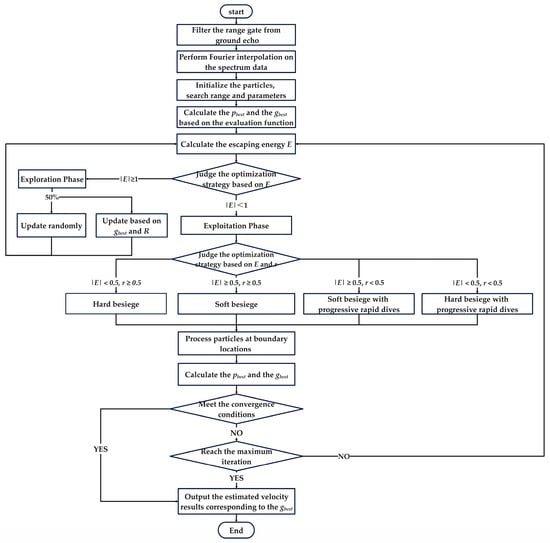
A flowchart illustrating the complete procedure of the proposed algorithm is presented in Figure 3.
Figure 3.
Flowchart of the SC-HHO algorithm.
Compared with other optimization algorithms, the HHO algorithm exhibits advantages in wind retrieval applications. In terms of global optimization capability, it employs diverse exploration strategies that effectively mitigate premature convergence and adeptly handle multimodal characteristics. Regarding local exploitation precision, the algorithm adaptively selects its optimization tactics based on the escape energy E and probabilistic mechanisms, enabling a refined search near the optimal solution. Compared with the PSO algorithm, HHO requires fewer defined parameters and demonstrates superior adaptive parameter tuning, resulting in lower sensitivity to initial conditions. Compared with the GA, HHO achieves faster convergence and higher computational efficiency. According to the fitness function and spectrum data, HHO’s distinctive cooperative hunting strategies empower it to escape local optima effectively and reliably locate the global or near-global optimum. Furthermore, the algorithm exhibits strong robustness against noise and incomplete data, which provides a practical advantage in UAV-based detection scenarios.
2.2.2. Algorithm Performance Validation
To evaluate the performance of the proposed algorithm, multiple wind retrieval methods were applied to process the measured data from a previously developed and validated airborne CDWL system (designated as ADWL-5). The parameters of the ADWL-5 are listed in Table 3. In the previous study, the LM-DSWF algorithm and the GA-PSO algorithm were validated using this CDWL [32]. The LM-DSWF algorithm is a classical wind retrieval method that first obtains the LOS wind velocities at multiple azimuth angles, then rapidly fits the three-dimensional wind components using the Levenberg–Marquardt method. This algorithm has been validated against the sounding balloon and offers high computational speed, but its performance degrades in low-SNR regions. In contrast, the GA-PSO algorithm directly retrieves three-dimensional wind velocities from spectrum data and performs better in low-SNR regions. It has been validated against the meteorological tower in ground-based experiments, but its processing speed is lower than that of the LM-DSWF algorithm. In this section, the LM-DSWF, GA-PSO, and SC-HHO algorithms are applied to the same airborne ADWL-5 data, with the two validated algorithms serving as benchmarks for preliminary evaluation of the proposed algorithm.
Table 3.
System parameters of the ADWL-5.
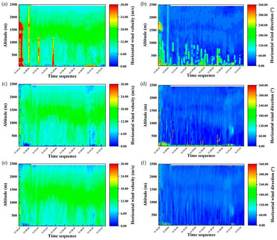
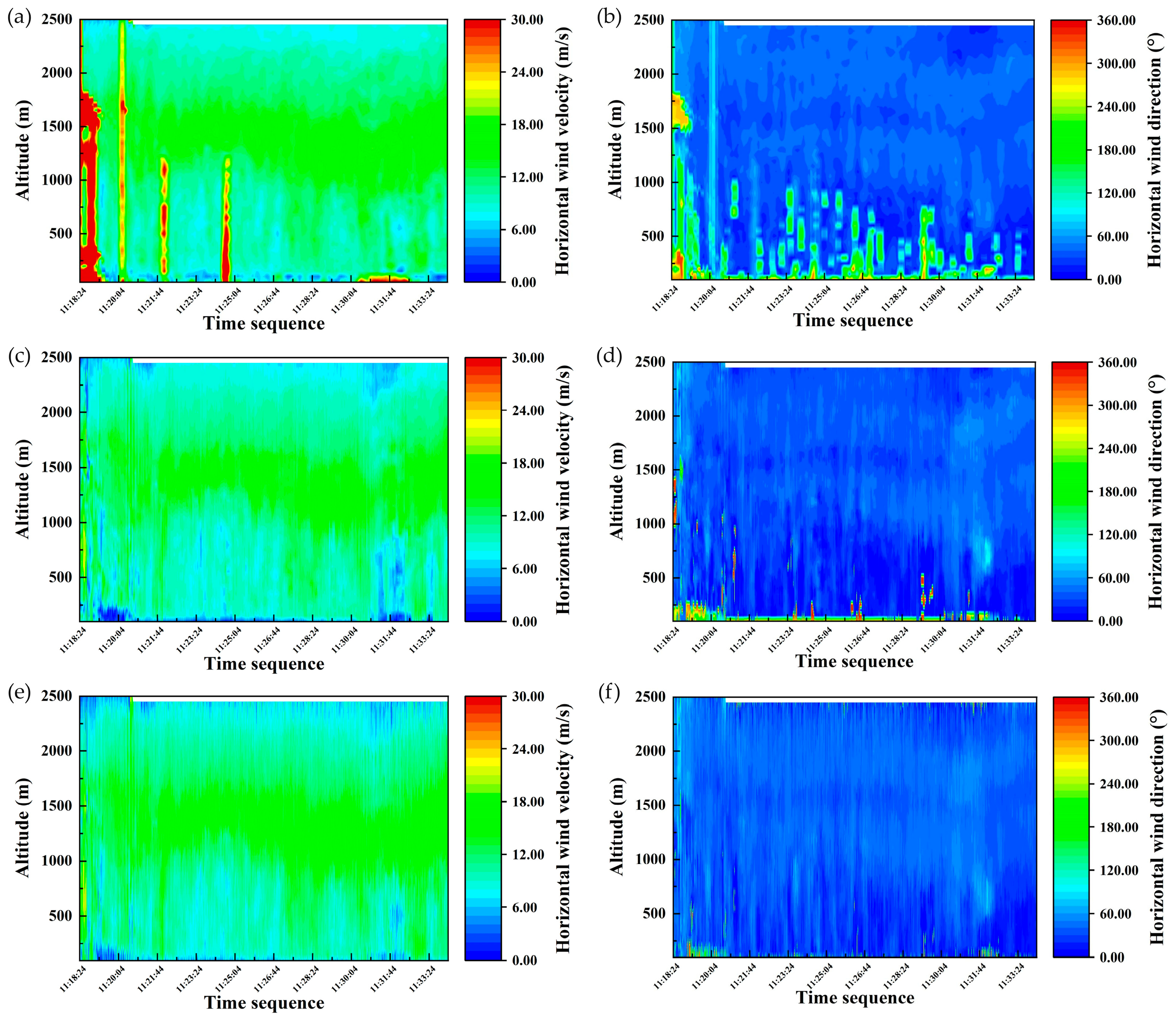
The spectrum data were acquired on 20 September 2024, during a level flight of a Y-12E aircraft at an altitude of 2.5 km equipped with the ADWL-5 system. To ensure a fair comparison of computational efficiency under identical hardware conditions, all processing in this section was performed on the same workstation equipped with an Intel Core i7-1255U processor and 16 GB of RAM. Figure 4 presents the continuously retrieved profiles of horizontal wind velocity and direction from the same data segment as processed by the three algorithms.
Figure 4.
Comparison of horizontal wind velocity and direction using different algorithms: (a,b) Wind retrieval results with LM-DSWF algorithm; (c,d) wind retrieval results with GA-PSO algorithm; (e,f) wind retrieval results with SC-HHO algorithm.
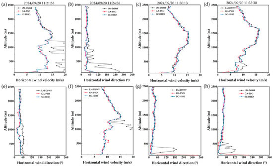
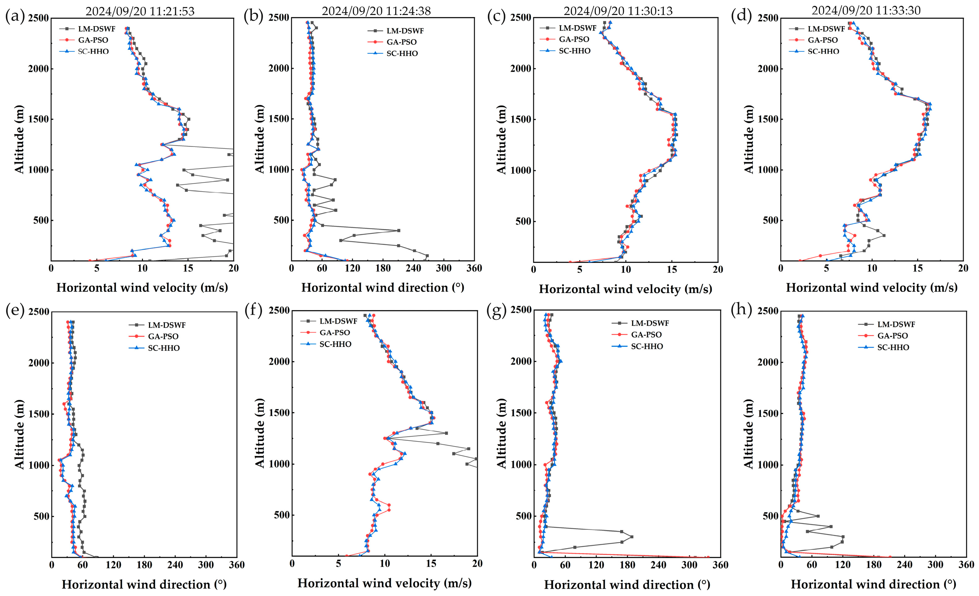
As shown in Figure 4, the continuous retrieved wind results from the three algorithms display broadly consistent spatial structures and temporal evolution. However, the LOS velocity retrieval in the LM-DSWF algorithm is constrained by SNR limitations, resulting in invalid data points, which are most notably during the initial phase of the results. This yields the poorest overall retrieval performance. In contrast, both the GA-PSO algorithm and the SC-HHO algorithm employ three-dimensional wind velocity estimation combined with spectrum-peak accumulation. This approach employs a form of additional accumulation, which enhances robustness for low-SNR range gates. As a result, both methods successfully reconstruct wind field features that the LM-DSWF algorithm fails to resolve. The retrieval performance of the proposed SC-HHO algorithm is comparable to that of the GA-PSO algorithm. A visual comparison of the retrieval results is provided in Figure 5, which shows four representative time points selected from Figure 4. Among the four selected time points, the first two correspond to failures of the LM-DSWF algorithm below 1500 m, whereas the latter two represent successful retrievals by all three algorithms. The results show strong consistency between the GA-PSO and the SC-HHO algorithms. The horizontal wind velocity results across all four time points exhibit similar distribution patterns, indicating relatively stable wind conditions during the flight. The low-altitude wind velocity and direction results from the latter two time points provide validation for the effectiveness of the wind fields reconstructed by the GA-PSO and SC-HHO algorithms during the first two time points.
Figure 5.
Wind retrieval results at four representative time points: (a–d) Horizontal wind velocity; (e–h) horizontal wind direction.
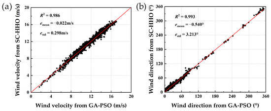
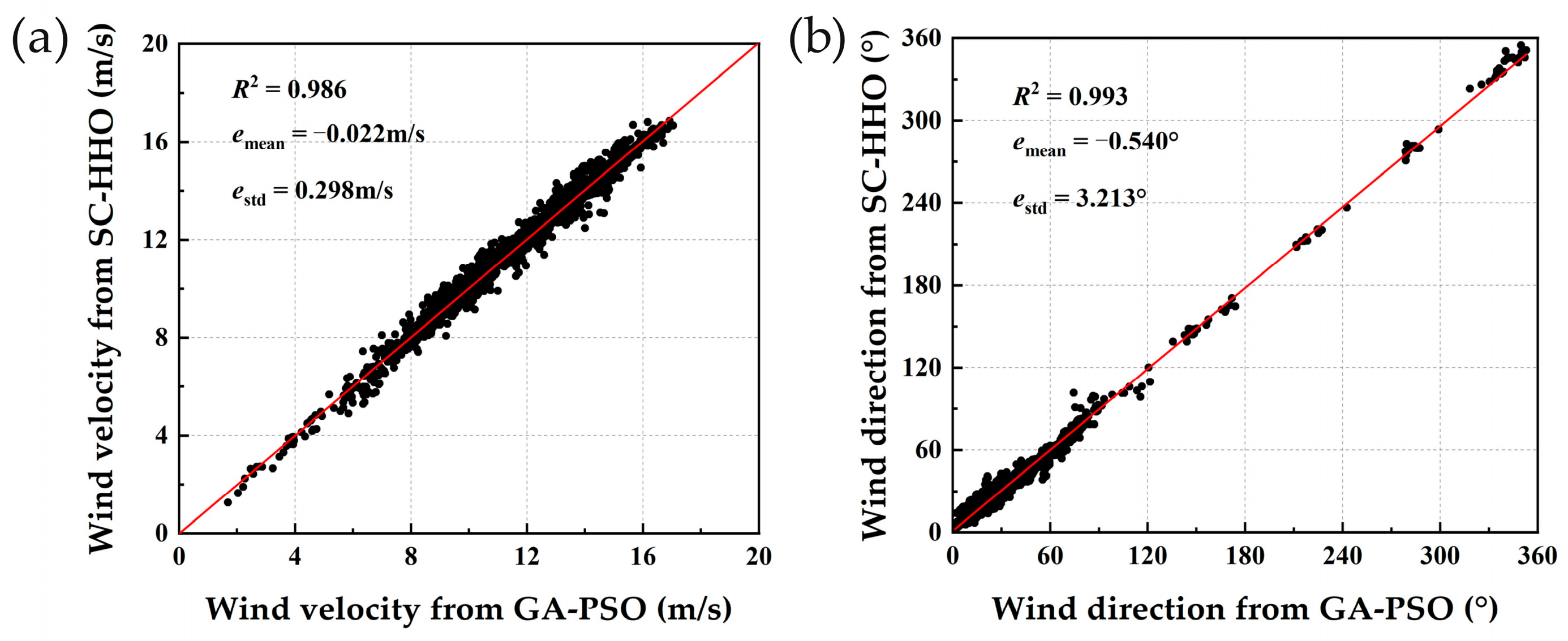
Since the SC-HHO algorithm significantly outperforms the LM-DSWF algorithm in low-SNR regions, a linear analysis and direct comparison with the GA-PSO algorithm, which also performs well under low-SNR conditions, is necessary to thoroughly evaluate its performance. Figure 6 presents the linear analysis results for the horizontal wind velocity and direction retrieved from the same spectrum data using the two algorithms. This analysis primarily focused on the altitude range from 200 m to 2000 m. The retrieved wind velocity and direction showed good consistency, with correlation coefficients of 0.986 and 0.993, respectively. Since the same raw data were processed, the mean deviations were close to zero, which is expected. The standard deviations of the differences were 0.298 m/s for wind velocity and 3.213° for wind direction, indicating that the SC-HHO algorithm yields slightly larger fluctuations than the GA-PSO algorithm.
Figure 6.
Comprehensive comparison of results retrieved by the GA-PSO and SC-HHO algorithms: (a) Wind velocity; (b) wind direction.
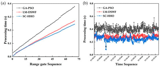
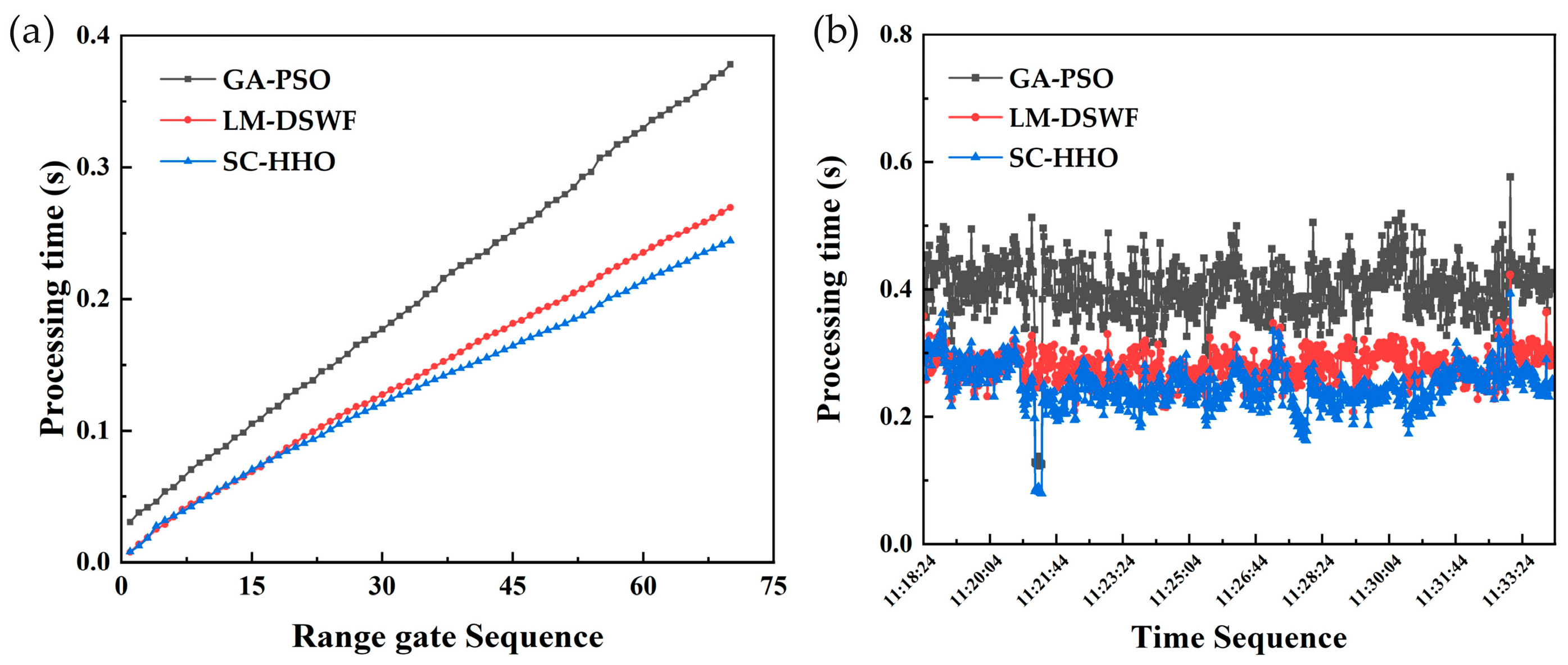
Figure 7 presents a statistical comparison of the processing times required by the three algorithms for the same data segment, which contains 70 range gates. The SC-HHO algorithm exhibits a clear computational speed advantage over the GA-PSO algorithm. When processing the first five range gates, the SC-HHO algorithm initially operates slightly slower than the LM-DSWF algorithm. However, its processing efficiency steadily improves with an increasing number of range gates and eventually surpasses that of LM-DSWF. Figure 7b summarizes the processing times for multiple consecutive data segments. The average processing time is 0.27 s for the LM-DSWF algorithm, 0.24 s for the SC-HHO algorithm, and 0.40 s for the GA-PSO algorithm. The SC-HHO algorithm agrees reasonably well with the GA-PSO results, although its performance is slightly lower than anticipated. This indicates that the specific optimization strategy adopted significantly influences both the final solution and the convergence behavior. Choosing the computationally faster HHO algorithm thus entails a trade-off that affects the accuracy of the retrieved velocities to some degree.
Figure 7.
Comparison of the processing times using different algorithms: (a) Processing time distribution over range gates for different algorithms; (b) processing time statistics for different algorithms.
3. Results
3.1. Comparative Detection Performance Experiment
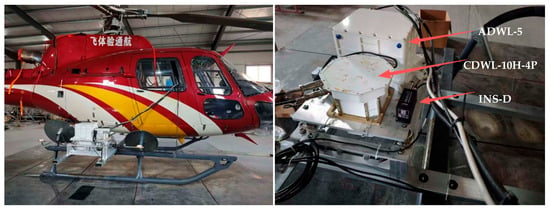
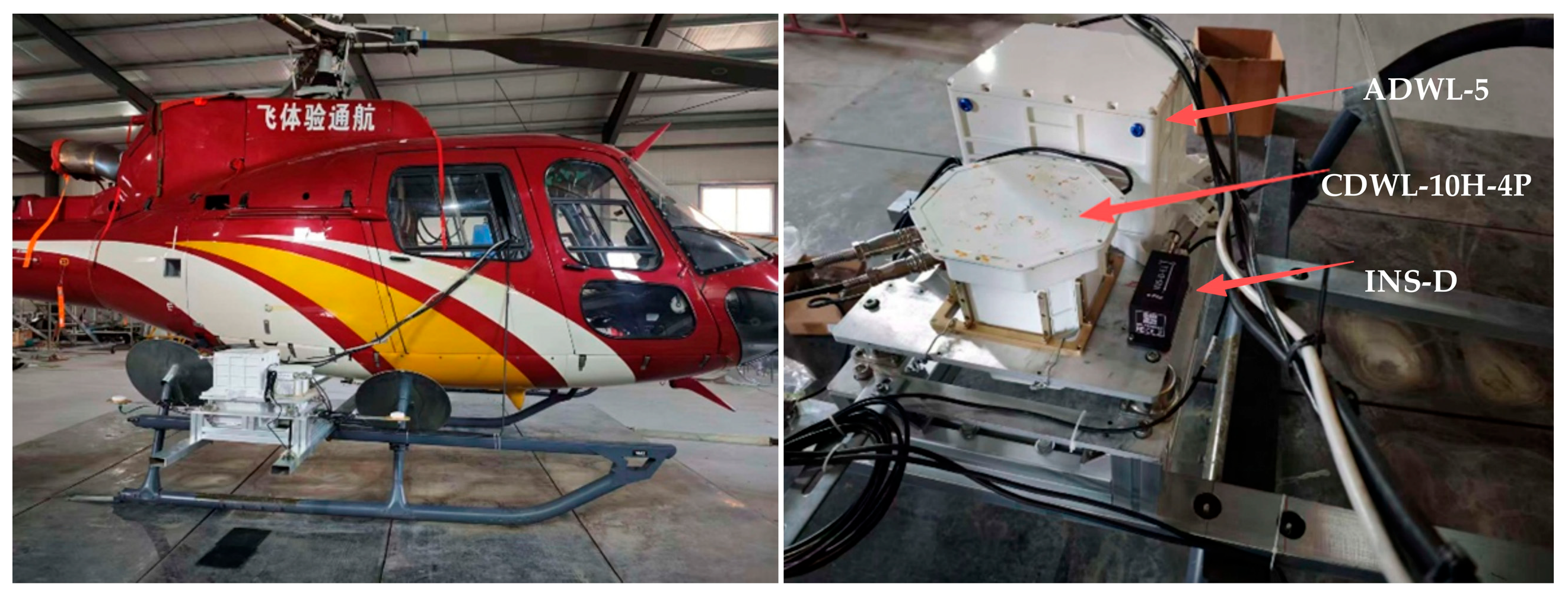
To evaluate the detection performance, the CDWL-10H-4P and the ADWL-5 were co-installed on an Airbus AS350 B3e helicopter in the comparative experiment. Both lidars were mounted on the helicopter’s landing gear using a shared fixed bracket, each configured for downward wind profile detection. An integrated navigation unit (INS-D, Beijing BDStar Navigation Co., Ltd., Beijing, China) was also mounted on the same bracket, providing GNSS velocity accuracy better than 0.05 m/s and attitude accuracy better than 0.1°. Although the unit has a data output rate of 20 Hz, its internal configuration limits the effective velocity data update rate to 1 Hz. This unit provided platform velocity and attitude data to the ADWL-5 and transmitted platform attitude information to the CDWL-10H-4P. During the flight, the helicopter maintained level flight. The experimental setup is illustrated in Figure 8.
Figure 8.
The experimental setup for the detection performance comparative experiment.
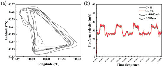
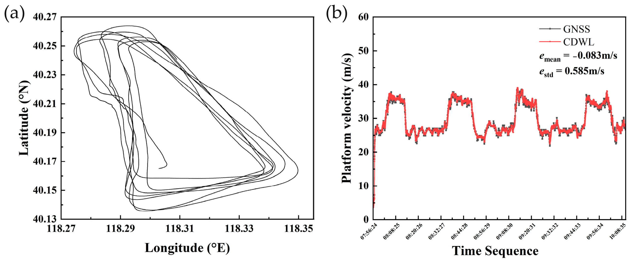
As shown in Figure 8, the CDWL-10H-4P exhibits a substantially higher level of integration than the ADWL-5, with its overall volume and weight reduced to approximately 30% and 20% of the latter, respectively. During the experiment, the ADWL-5 system employed the LM-DSWF algorithm, a combination previously validated through comparisons with the sounding balloon in flight experiments at approximately 6 km altitude. The CDWL-10H-4P system applied the SC-HHO algorithm for wind retrieval. To validate the effectiveness of the SC-HHO algorithm under field conditions, the three-dimensional velocity data derived from ground-echo range gates were extracted and compared with GNSS data, with the results presented in Figure 9.
Figure 9.
Analysis of platform velocity retrieval performance: (a) Flight test trajectory in the comparative experiment; (b) comparison between the platform velocity retrieved by CDWL and the platform velocity recorded by GNSS.
The results indicate that the platform motion velocity derived by the CDWL-10H-4P using the self-compensating mechanism agrees well with the GNSS-recorded velocity. As shown in Figure 9, the velocity curve from the CDWL-10H-4P appears smoother, whereas the GNSS-recorded velocity exhibits a noticeable lag. This observation suggests that the effective update rate of the GNSS velocity measurement is lower than that of the CDWL, contributing to a larger standard deviation in the velocity error. Additionally, the relatively high flight altitude in this experiment results in a more complex ground footprint of the laser beam, which may further contribute to the velocity deviation. On this basis, the continuous measurements from both instruments during the comparative experiment are presented in Figure 10.
Figure 10.
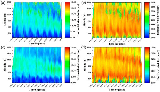
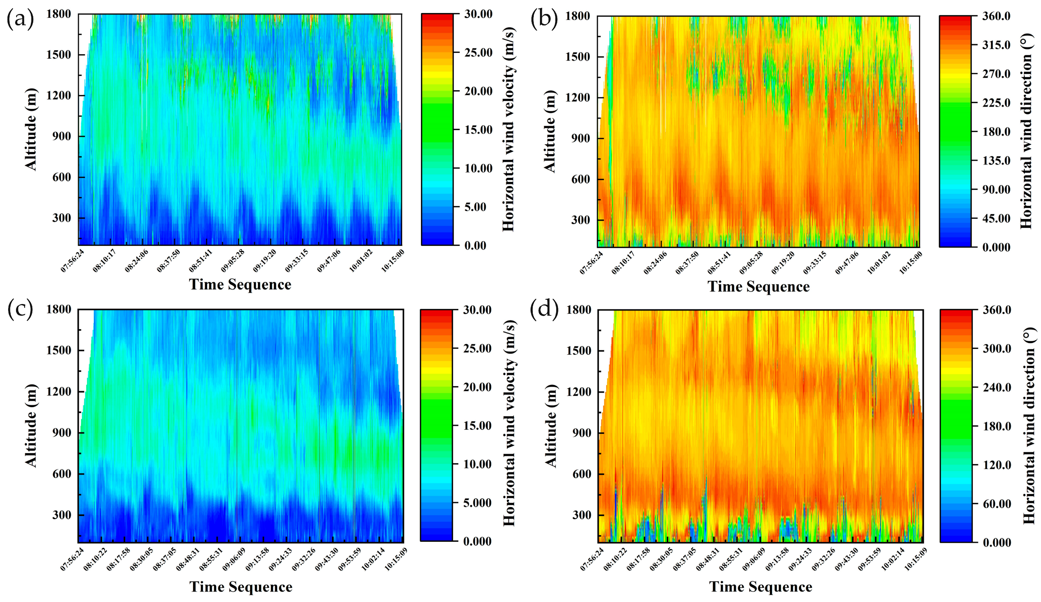
Continuous wind retrieval results in comparative experiment: (a,b) Wind field results from ADWL-5; (c,d) wind field results from CDWL-10H-4P with the SC-HHO algorithm.
As shown in Figure 10, the wind fields retrieved by the two systems show strong consistency in both temporal continuity and spatial structure. Notably, the results processed with the LM-DSWF algorithm contain extended segments of invalid data around 1500 m and 1800 m altitude. The corresponding spectrum data exhibit significantly degraded SNR, which is likely attributable to sparse aerosol distributions at higher altitudes. The LM-DSWF algorithm fails to reliably estimate LOS wind speed under such low-SNR conditions, leading to a breakdown of the three-dimensional wind retrieval. This condition reduces backscattered laser while avoiding significant laser attenuation, thereby still permitting effective wind retrieval at lower altitudes. Based on the data in Figure 10, the vertical extent of invalid wind retrieval by the LM-DSWF algorithm between 09:19 and 10:01 spans at least 450 m. In contrast, the SC-HHO algorithm successfully recovers the wind retrieval in this region. When implemented on the CDWL-10H-4P system, the SC-HHO algorithm extends the effective detection range by approximately 33.3% compared to the conventional airborne CDWL system. This improvement stems mainly from spectrum accumulation over multiple scanning azimuths, which enhances the effective SNR while embedding spatiotemporal continuity constraints into the retrieval process.
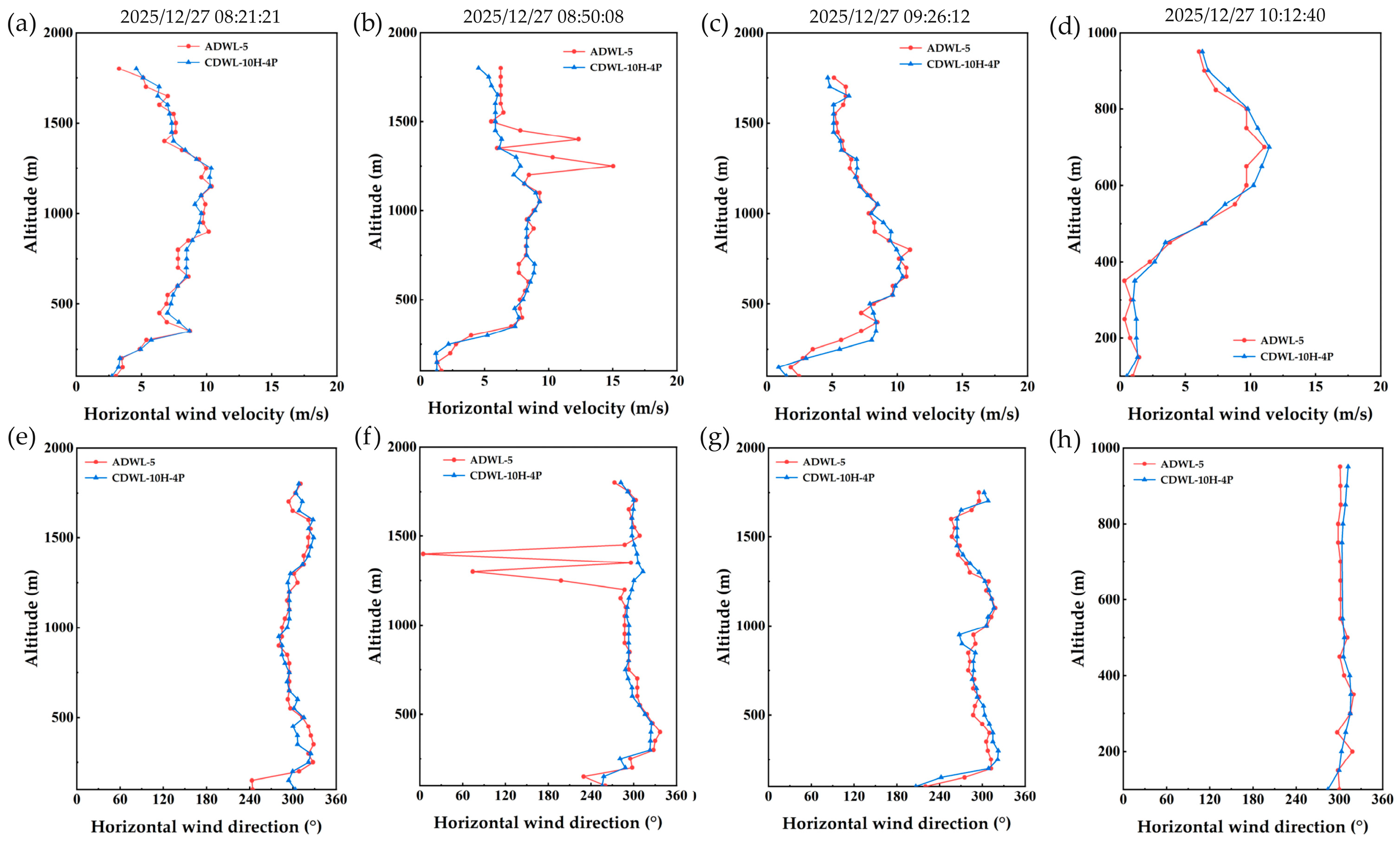
To further evaluate the detection performance at discrete time intervals, four sample sets were extracted from the continuous measurement series for detailed comparison. The results are presented in Figure 11.
Figure 11.
Wind retrieval result at selected time intervals: (a–d) Horizontal wind velocity; (e–h) horizontal wind direction.
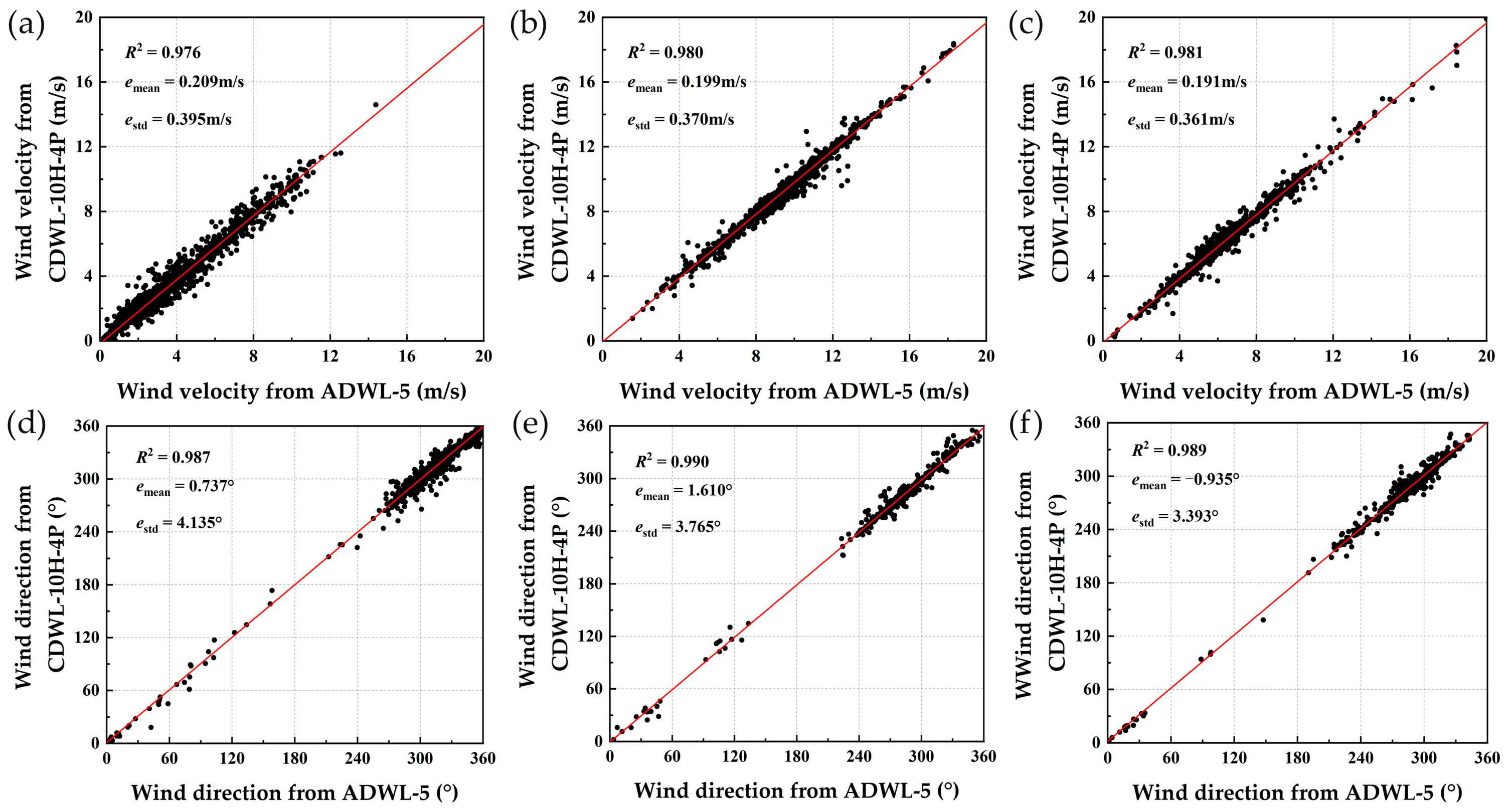
The wind velocity and direction retrieved by the CDWL-10H-4P show close consistency with the measurements from the ADWL-5 in the distribution patterns. The linear analysis was performed between the results retrieved by ADWL-5 and CDWL-10H-4P in different altitude regions, as presented in Figure 12.
Figure 12.
Comparison of horizontal wind velocity and direction at different altitude gates: (a,d) Approximately 500 m; (b,e) 900 m; (c,f) 1700 m.
Linear analysis indicates that the horizontal wind velocity retrieved by the CDWL-10H-4P and the ADWL-5 are highly correlated across all altitude levels, with a correlation coefficient exceeding 0.976 and a standard deviation of the velocity differences better than 0.395 m/s. For wind direction, the two systems achieve a correlation coefficient above 0.987 with a standard deviation of the direction differences within 4.135°. These results confirm that the CDWL-10H-4P system, combined with the SC-HHO algorithm, can retrieve wind profiles with reasonable precision, meeting the operational demands for low-altitude wind field detection. Furthermore, the discrepancy in retrieved wind velocity between the two systems diminishes at higher altitudes. This trend can be attributed to the more stable wind conditions typically present at elevated levels, in contrast to the complex turbulent structures prevalent at lower altitudes. Such turbulence introduces more intricate noise into the spectrum data, leading to greater dispersion in the optimization results of the different retrieval algorithms.
3.2. UAV-Borne Wind Measurement Experiment
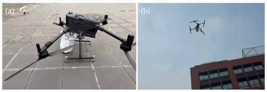
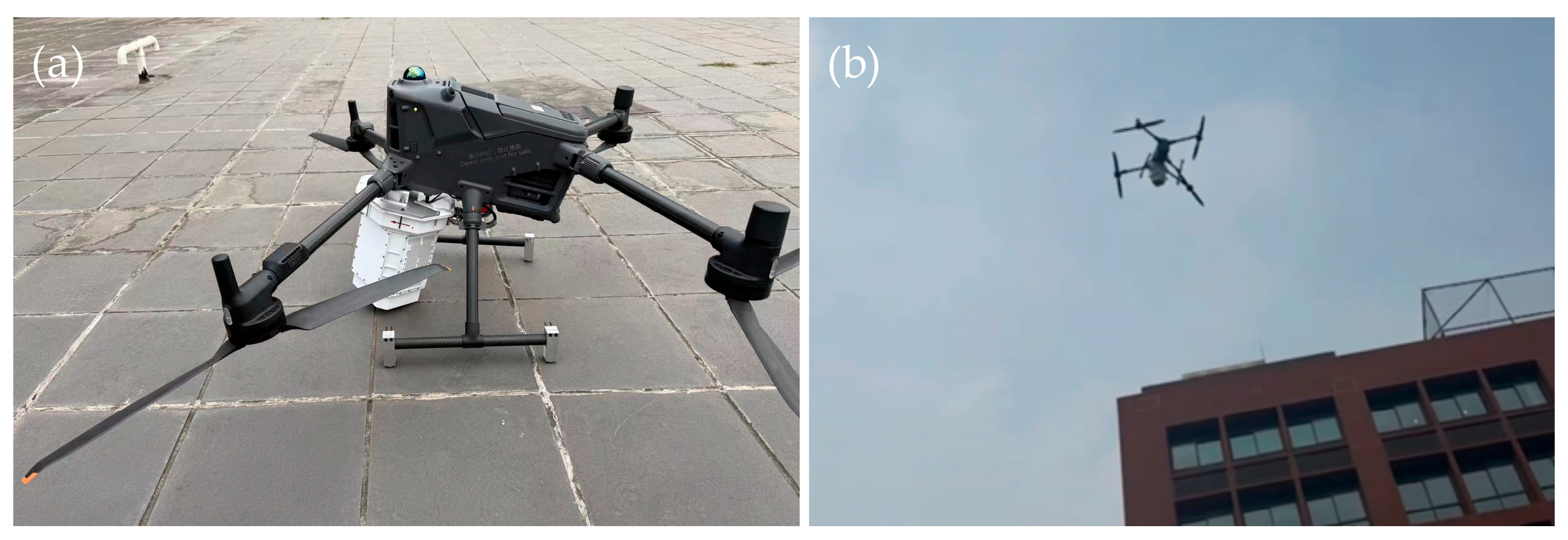
Given that compact UAVs typically operate below 1 km in altitude, the CDWL-10H-4P was installed on a payload platform beneath the DJI Matrice 400. Motion velocity and attitude data from the UAV’s navigation module were transmitted to the core processing unit of the CDWL-10H-4P. The attitude information was used for motion compensation during wind field retrieval, while the velocity data served to validate the feasibility of the SC-HHO algorithm. By utilizing GNSS signals, the DJI Matrice 400 provides position measurements with an accuracy better than 0.02 m, allowing precise monitoring of platform motion. Owing to the relatively low flight altitude, the CDWL-10H-4P was configured to reduce the accumulated number, achieving a high data rate of 10 Hz. On 8 January 2026, a UAV-borne experiment was conducted near Beijing, China. The UAV maintained a constant altitude of 500 m while performing primarily level-flight maneuvers. The flight trajectory was designed as a rectangular path within the latitude range of 40.184°N to 40.194°N and the longitude range of 117.226°E to 117.238°E. The experimental setup for the UAV-borne wind measurement experiment is illustrated in Figure 13.
Figure 13.
The experimental setup for the UAV-borne wind measurement experiment: (a) DJI Matrice 400 equipped with the CDWL-10H-4P; (b) DJI Matrice 400 performing a wind sensing mission.
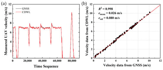
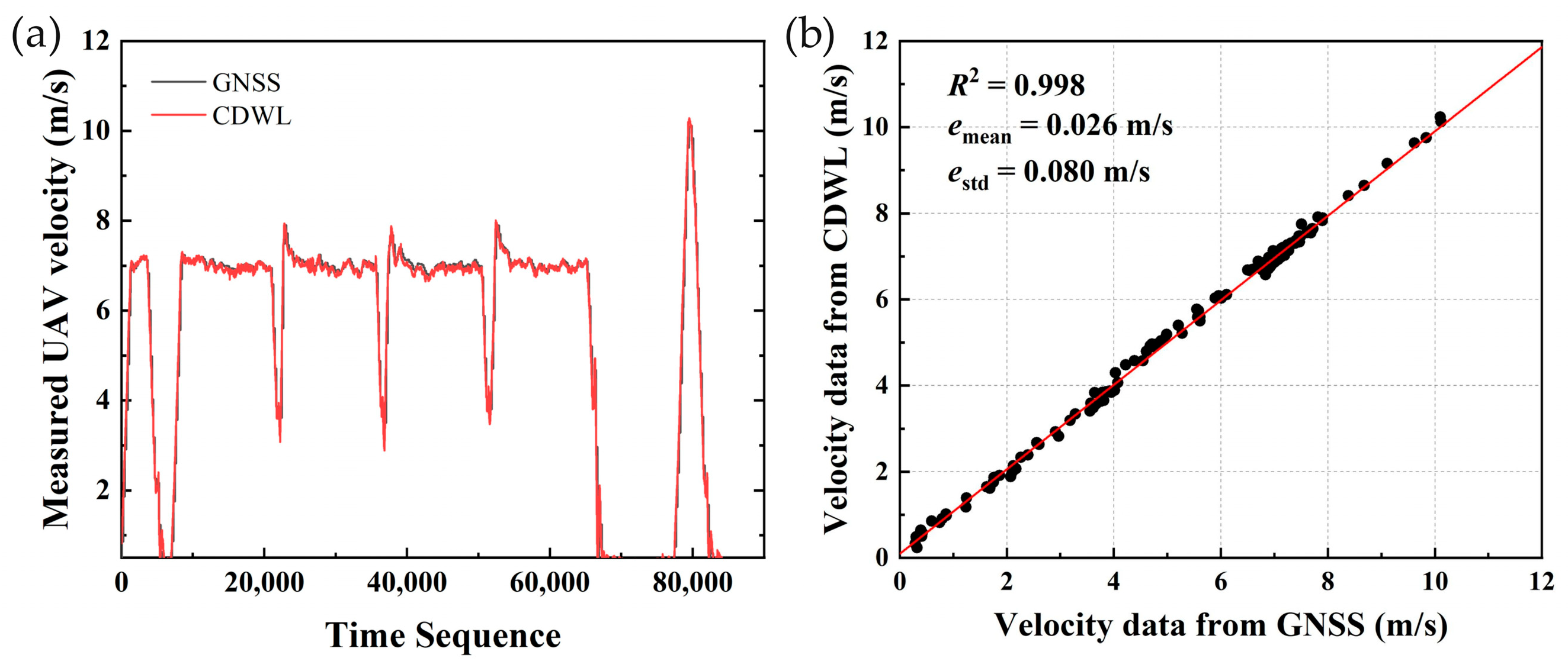
A comparison of the retrieved velocities is provided in Figure 14 for evaluating the CDWL’s ability to retrieve platform velocity from ground-echo range gates. To provide a clearer assessment of the velocity retrieval performance, the magnitudes of the retrieved platform motion velocity vectors were directly compared with reference measurements.
Figure 14.
Analysis of platform velocity retrieval performance: (a) Comparison between the platform velocity retrieved by CDWL and the platform velocity recorded by GNSS; (b) the linear analysis between CDWL-retrieved results and GNSS-recorded results at the GNSS update instants.
As shown in Figure 14a, the CDWL-10H-4P successfully retrieves platform motion velocity from ground-echo range gates. The retrieved velocity closely follows the trend of the GNSS-based reference. At the GNSS update instants, the CDWL measurements align well with the GNSS values. Therefore, Figure 14b presents a linear analysis between the GNSS velocity at these synchronized moments and the corresponding CDWL measurements. The results yield a correlation coefficient of 0.998, a mean velocity deviation of 0.026 m/s, and a standard deviation of 0.080 m/s. Compared with previous experimental results, the UAV-borne CDWL achieved improved platform velocity measurement performance, likely due to the lower flight altitude and reduced test range. Additionally, the CDWL was configured with a higher data rate in this experiment, further mitigating data inconsistencies caused by the scanning process during flight. Overall, the platform velocity derived from the CDWL-10H-4P satisfies the requirements for motion compensation in airborne wind retrieval, demonstrating low dependence on external references while maintaining high sensitivity to platform dynamics. This comparative analysis further enables the calibration of residual installation misalignments and actual laser pointing angles of the CDWL system.
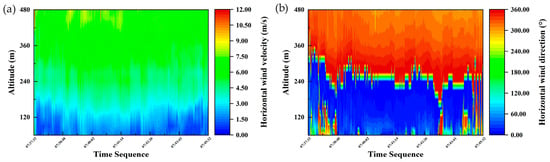
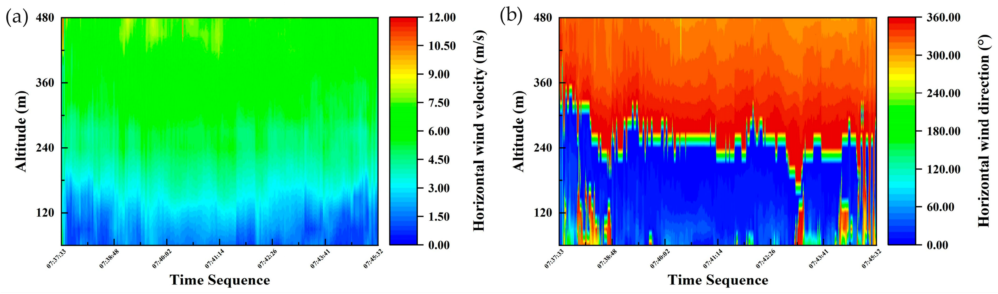
Figure 15 presents the continuous wind measurement data obtained during the UAV-borne wind measurement experiment. The results indicate that the CDWL-10H-4P effectively suppresses errors induced by UAV platform motion, allowing robust and continuous retrieval of wind profiles throughout low-altitude flight operations.
Figure 15.
Wind field results obtained during the UAV-borne wind measurement experiment: (a) Horizontal wind velocity; (b) horizontal wind direction.
As shown in Figure 15, both wind velocity and direction exhibit distinct vertical stratification with notable numerical differences, underscoring the importance of UAV-borne wind sensing for obtaining dynamic wind profile information. Pronounced oscillations in wind velocity and direction appear at around 120 m altitude, particularly during two periods: 07:37:33–07:38:48 and 07:43:41–07:52:13. These variations may be related to fluctuations in wind direction near 360°, as well as to a sharp reduction in SNR at this altitude or rapid changes in UAV attitude. In low-altitude detection scenarios, complex terrain and turbulence induce localized wind field variations, leading to inhomogeneous aerosol distributions. Moreover, frequent attitude adjustments of the UAV during flight can cause discontinuities in the detection area from the scanning process. All these factors affect the continuity of three-dimensional wind retrieval and represent a typical challenge in UAV-based wind sensing. To address this issue, further UAV-borne flight experiments and data analyses are needed, along with optimization of the data processing algorithm and comparative validation of the UAV-borne CDWL against wind measurement devices based on different principles.
4. Discussion
The miniaturized CDWL system developed for compact UAV platforms achieves a significant reduction in SWaP through an optimized optical antenna design and a highly consolidated single-core-board architecture. Through ongoing parameter optimization, component refinement, and opto-mechanical iteration, the next-generation CDWL is projected to weigh under 2 kg, enabling compatibility with a broader range of UAV models. Conventional ground-based CDWL systems are fixedly deployed on the ground and operate in a long-term stable observation mode, typically with a data rate no higher than 1 Hz and offering limited spatial coverage. In contrast, the CDWL proposed in this paper, when mounted on a UAV, can dynamically measure wind profiles over a much larger geographical area. This capability has the potential to provide low-altitude meteorological services with higher timeliness for future tasks such as coordinated UAV swarm flights and routine UAV inspections. Furthermore, forward-looking wind measurement appears to offer broader application potential for UAV-borne wind sensing, and we will therefore pursue related research in our future work.
To balance accuracy and efficiency, we retained the combined framework of optimization algorithms and spectrum accumulation method, which achieves processing speeds reaching those of traditional LM-DWSF-based methods. Owing to differences in optimization mechanisms, the results of the SC-HHO algorithm show slight deviations from those of the GA-PSO method. After evaluating both detection performance and computational efficiency, the faster HHO algorithm was selected for this study. Although no decisive breakthrough was achieved in this direction, we propose that integrating further acceleration techniques into the GA-PSO framework could better balance computational speed and wind-retrieval accuracy in future research.
The ground-echo-based self-compensation mechanism enables estimation of platform motion velocity while reducing reliance on external data sources such as GNSS, thereby helping to lower SWaP and system cost. A prerequisite for this mechanism is the presence of stationary ground targets with sufficient backscattering, which defines its applicability boundary. Over most land areas, the mechanism can accurately retrieve platform velocity. However, over dynamic surfaces such as oceans or rivers, the flow velocity of the water introduces an interference term, potentially causing this mechanism to fail. In the Comparative Detection Performance Experiment, the platform was a helicopter operating at relatively high altitudes over a wide area, resulting in complex ground conditions including towns, mountains, and reservoirs. Consequently, the velocity obtained from the self-compensation mechanism exhibited a standard deviation with respect to GNSS velocity that, although acceptable, was relatively large. In contrast, the UAV-borne experiment was conducted over a relatively flat area where the ground targets were essentially stationary, leading to better velocity estimation performance. Thus, the mechanism’s effectiveness depends mainly on ground target conditions, with flight altitude having a limited impact. It should remain valid in most UAV scenarios, though further flight experiments are needed for confirmation.
Furthermore, experiments revealed that ground-echo effects are similar to the near-field blind zone in CDWL systems. It can be observed that ground targets with high reflectivity produce echoes significantly stronger than aerosol echoes. This results in spectrum peaks at the range gate corresponding to the ground position that are significantly higher than those of wind signals. The two types of signals can be separated using an empirical threshold based on the spectrum peak magnitude. In data processing, continuous time-domain signals are decomposed by range gates and processed via FFT. As a result, the spatial range affected by ground echoes is generally larger than the actual range, and this influence range is related to the laser pulse width. This constraint poses a challenge for wind measurement applications using low-altitude UAVs. Existing research has explored dynamic temporal signal truncation to suppress such hard-target interference, representing a possible way for advancing airborne CDWL technology.
5. Conclusions
In summary, this study meets the need for remote wind sensing on compact UAVs through the development of a lightweight CDWL system, the CDWL-10H-4P. To the best of our knowledge, this is the smallest fully functional CDWL reported to date that can be completely integrated onto a small UAV platform. A corresponding SC-HHO algorithm is also proposed for efficient downward wind-profile retrieval under UAV-borne conditions. The performance of the CDWL-10H-4P and the proposed algorithm was validated through the comparative experiment and the UAV-borne experiment. Processing of earlier airborne data demonstrated that the proposed algorithm outperforms the conventional LM-DSWF method in terms of processing speed and retrieval performance. In a comparative detection performance experiment conducted with a reference airborne CDWL system, the CDWL-10H-4P demonstrated consistent wind field detection capability. The retrieved horizontal wind velocity showed a correlation coefficient exceeding 0.976 with a standard deviation below 0.395 m/s across altitude levels. For wind direction, the correlation coefficient exceeded 0.987, with a standard deviation of directional differences within 4.135°. In UAV-borne experiments, the CDWL-10H-4P successfully retrieved platform velocity from ground echoes, showing strong agreement with GNSS data. The correlation coefficient achieves above 0.998, with a mean velocity deviation of 0.026 m/s and a standard deviation of 0.080 m/s. Although the continuous wind measurement results exhibit some fluctuation, they demonstrate that the system can operate reliably on a moving UAV platform while reducing dependence on external sensors.
This study, therefore, provides a viable and previously limited technical solution for UAV-based atmospheric remote sensing. Future research will incorporate comparative reference devices based on different measurement principles. Considering the limited flight altitude of UAVs and the inherent limitations of sounding balloons, a meteorological tower remains a more suitable reference. By designing UAV-borne CDWL flights that hover near or circle a meteorological tower while continuously measuring wind profiles, the wind measurement performance of the UAV-borne CDWL under various motion states can be thoroughly validated.
Author Contributions
Conceptualization, X.Z. and Z.L.; methodology, X.Z. and Z.L.; software, X.Z. and S.H.; validation, S.H. and Y.Z.; formal analysis, R.W.; investigation, X.Z. and Y.Z.; resources, D.M.; data curation, X.Z. and S.H.; writing—original draft preparation, X.Z.; writing—review and editing, Z.L. and R.W.; visualization, X.Z.; supervision, Z.L.; project administration, Z.L. and C.K.; funding acquisition, Z.L. and R.W. All authors have read and agreed to the published version of the manuscript.
Funding
This research was funded by the Key Research Project of the Chinese Academy of Sciences (KGFZD-145-23-17) and the Project (3050502).
Data Availability Statement
The data presented in this study are available on request from the corresponding author.
Conflicts of Interest
The authors declare no conflicts of interest.
References
- Ilyas, M.; Noack, B.R.; Hu, G.; Xiong, H.; Gao, N.; Khan, A.; Yang, Y. Drone anemometry of atmospheric winds—A review Available to Purchase. Phys. Fluids 2025, 37, 061302. [Google Scholar] [CrossRef] [Scilit]
- Campagna, L.M.; Carlucci, F.; Fiorito, F.; Marinelli, E.R.; Ottomanelli, M.; Marinelli, M. Mapping the Integration of Urban Air Mobility into the Built Environment: A Bibliometric Analysis and a Scoping Review. Drones 2025, 9, 692. [Google Scholar] [CrossRef] [Scilit]
- Gu, T.J.; Zhao, Y.F.; Ren, X.H. Integrating wind field analysis in UAV path planning: Enhancing safety and energy efficiency for urban logistics. Chin. J. Aeronaut. 2026, 39, 103605. [Google Scholar] [CrossRef] [Scilit]
- Li, Z.N.; Pu, O.; Pan, Y.Y.; Huang, B.; Zhao, Z.F.; Wu, H.H. A Study on Measuring the Wind Field in the Air Using a Multi-rotor UAV Mounted with an Anemometer. Bound.-Layer. Meteorol. 2023, 188, 1–27. [Google Scholar] [CrossRef] [Scilit]
- Zhang, X.F.; Luo, B.S.; Liu, Y.X.; Li, J.Q.; Liang, T.W.; Hong, J.R.; Li, C. Development of UAV-based system for simultaneous wind and particle measurements in the atmospheric boundary layer. Exp. Fluids 2025, 66, 139. [Google Scholar] [CrossRef] [Scilit]
- Rautenberg, A.; Schön, M.; zum Berge, K.; Mauz, M.; Manz, P.; Platis, A.; van Kesteren, B.; Suomi, I.; Kral, S.T.; Bange, J. The Multi-Purpose Airborne Sensor Carrier MASC-3 for Wind and Turbulence Measurements in the Atmospheric Boundary Layer. Sensors 2019, 19, 2292. [Google Scholar] [CrossRef] [Scilit]
- Abichandani, P.; Lobo, D.; Ford, G.; Bucci, D.; Kam, M. Wind Measurement and Simulation Techniques in Multi-Rotor Small Unmanned Aerial Vehicles. IEEE Access 2020, 8, 54910–54927. [Google Scholar] [CrossRef] [Scilit]
- Stuber, L.; Jeger, S.L.; Zufferey, R.; Floreano, D. Miniature Multihole Airflow Sensor for Lightweight Aircraft Over Wide Velocity and Angular Range. IEEE Robot. Autom. Lett. 2025, 10, 10722–10728. [Google Scholar] [CrossRef] [Scilit]
- Yang, Y.R.; Zhang, Y.H.; Han, T.R.; Xie, C.H.; Liu, Y.Y.; Huang, Y.F.; Zhou, J.T.; Sun, H.J.; Zhao, D.L.; Zhang, K.; et al. A correction algorithm for rotor-induced airflow and flight attitude changes during three-dimensional wind velocity measurements made from a rotary unoccupied aerial vehicle. Atmos. Meas. Tech. 2025, 18, 3035–3050. [Google Scholar] [CrossRef] [Scilit]
- Palomaki, R.T.; Rose, N.T.; Bossche, M.V.D.; Sherman, T.J.; Wekker, S.F.D. Wind estimation in the lower atmosphere using multirotor aircraft. J. Atmos. Ocean. Technol. 2017, 34, 1183–1191. [Google Scholar] [CrossRef] [Scilit]
- Shimura, T.; Inoue, M.; Tsujimoto, H.; Sasaki, K.; Iguchi, M. Estimation of wind vector profile using a hexarotor unmanned aerial vehicle and its application to meteorological observation up to 1000 m above surface. J. Atmos. Ocean. Technol. 2018, 35, 1621–1631. [Google Scholar] [CrossRef] [Scilit]
- BenMoshe, N.; Fattal, E.; Leitl, B.; Arav, Y. Using Machine Learning to Predict Wind Flow in Urban Areas. Atmosphere 2023, 14, 990. [Google Scholar] [CrossRef] [Scilit]
- Zhu, S.; Zhao, T.; Zhang, H.; Chen, Y.; Yang, D.; Liu, Y.; Cao, J. UAVs’ Flight Dynamics Is All You Need for Wind Velocity and Direction Measurement in Air. Drones 2025, 9, 466. [Google Scholar] [CrossRef] [Scilit]
- Liu, Z.; Barlow, J.F.; Chan, P.-W.; Fung, J.C.H.; Li, Y.; Ren, C.; Mak, H.W.L.; Ng, E. A Review of Progress and Applications of Pulsed Doppler Wind LiDARs. Remote Sens. 2019, 11, 2522. [Google Scholar] [CrossRef] [Scilit]
- Schroeder, P.; Brewer, W.A.; Choukulkar, A.; Weickmann, A.; Zucker, M.; Holloway, M.W.; Sandberg, S. A Compact, Flexible, and Robust Micropulsed Doppler Lidar. J. Atmos. Ocean. Technol. 2020, 37, 1387–1402. [Google Scholar] [CrossRef] [Scilit]
- Xia, H.; Chen, Y.; Yuan, J.; Su, L.; Yuan, Z.; Huang, S.; Zhao, D. Windshear Detection in Rain Using a 30 km Radius Coherent Doppler Wind Lidar at Mega Airport in Plateau. Remote Sens. 2024, 16, 924. [Google Scholar] [CrossRef] [Scilit]
- Vasiljević, N.; Harris, M.; Tegtmeier Pedersen, A.; Rolighed Thorsen, G.; Pitter, M.; Harris, J.; Bajpai, K.; Courtney, M. Wind sensing with drone-mounted wind lidars: Proof of concept. Atmos. Meas. Tech. 2020, 13, 521–536. [Google Scholar] [CrossRef] [Scilit]
- Wang, Q.C.; Wu, S.H.; Zhang, H.W.; Liu, B.Y.; Zhang, K.L. Observation and data processing of offshore wind field based on UAV-borne Doppler lidar. J. Infrared Millim. Waves 2021, 40, 516–529. [Google Scholar] [CrossRef]
- Yew, R.L.; Johnson, B.C.; Gibson, B.C.; Mohamed, A. A review of airborne Doppler lidar for wind-sensing. Progress. Aerosp. Sci. 2025, 157, 101127. [Google Scholar] [CrossRef] [Scilit]
- Spuler, S.M.; Richter, D.; Spowart, M.P.; Kathrin Rieken, K. Optical fiber-based laser remote sensor for airborne measurement of wind velocity and turbulence. Appl. Opt. 2011, 50, 842–851. [Google Scholar] [CrossRef] [Scilit] [PubMed]
- Kavaya, M.; Beyon, J.; Koch, G.; Petros, M.; Petzar, P.; Singh, U.; Trieu, B.; Yu, J. The Doppler Aerosol Wind (DAWN) Airborne, Wind-Profiling Coherent-Detection Lidar System: Overview and Preliminary Flight Results. J. Atmos. Ocean. Technol. 2014, 31, 826–842. [Google Scholar] [CrossRef] [Scilit]
- Witschas, B.; Rahm, S.; Dörnbrack, A.; Wagner, J.; Rapp, M. Airborne Wind Lidar Measurements of Vertical and Horizontal Winds for the Investigation of Orographically Induced Gravity Waves. J. Atmos. Ocean. Technol. 2017, 34, 1371–1386. [Google Scholar] [CrossRef] [Scilit]
- Gasch, P.; Kasic, J.; Maas, O.; Wang, Z. Advancing airborne Doppler lidar wind profiling in turbulent boundary layer flow—An LES-based optimization of traditional scanning-beam versus novel fixed-beam measurement systems. Atmos. Meas. Tech. 2023, 16, 5495–5523. [Google Scholar] [CrossRef] [Scilit]
- Peña, A.; Mann, J.; Angelou, N.; Jacobsen, A. A Motion-Correction Method for Turbulence Estimates from Floating Lidars. Remote Sens. 2022, 14, 6065. [Google Scholar] [CrossRef] [Scilit]
- Malekmohammadi, S.; Duscha, C.; Jenkins, A.D.; Kelberlau, F.; Gottschall, J.; Reuder, J. Evaluating the Performance of Pulsed and Continuous-Wave Lidar Wind Profilers with a Controlled Motion Experiment. Remote Sens. 2024, 16, 3191. [Google Scholar] [CrossRef] [Scilit]
- Zhu, J.S.; Li, Z.G.; Liu, Z.S. Horizontal wind velocity retrieval using a Levenberg-Marquardt algorithm for an airborne wind lidar. J. Appl. Remote Sens. 2016, 10, 026009. [Google Scholar] [CrossRef] [Scilit]
- Lin, R.; Guo, P.; Chen, H.; Chen, S.; Zhang, Y. Smoothed accumulated spectra based wDSWF method for real-time wind vector estimation of pulsed coherent Doppler lidar. Opt. Express 2022, 30, 180–194. [Google Scholar] [CrossRef] [Scilit]
- Yu, J.; Guo, P.; Chen, S.Y.; Chen, H.; Cao, R.Z.; Xie, Y.X.; Zou, Z.F.; Yin, S.L.; Yu, Y.H.; Liu, J.S.; et al. Wind vector retrieval algorithm for a coherent Doppler lidar based on KNN-COOKS. Appl. Opt. 2025, 64, 2640–2652. [Google Scholar] [CrossRef] [Scilit]
- Stephan, A.; Wildmann, N.; Smalikho, I.N. Effectiveness of the MFAS Method for Determining the Wind Velocity Vector from Windcube 200s Lidar Measurements. Atmos. Ocean. Opt. 2019, 32, 555–563. [Google Scholar] [CrossRef] [Scilit]
- Yuan, L.C.; Liu, H.; Liu, J.Q.; Zhu, X.P.; Hu, G.Y.; Chen, W.B. Wind vector estimation of coherent doppler wind Lidar based on genetic algorithm. Chin. J. Lasers 2020, 47, 0810004. [Google Scholar] [CrossRef] [Scilit]
- Liu, Z.; Yuan, L.C.; Tang, J.; Zhang, Y.P.; Liu, J.Q.; Zhu, X.P.; Yang, J.X.; Shi, W.; Chen, W.B. Coherent Doppler lidar wind retrieval for a typhoon based on the genetic simulated annealing algorithm. Chin. Opt. Lett. 2024, 22, 040101. [Google Scholar] [CrossRef] [Scilit]
- Zhang, X.; Zang, X.; Sang, Y.; Lian, X.; Gao, C. An Enhanced Three-Dimensional Wind Retrieval Method Based on Genetic Algorithm-Particle Swarm Optimization for Coherent Doppler Wind Lidar. Remote Sens. 2025, 17, 1616. [Google Scholar] [CrossRef] [Scilit]
- Heidari, A.A.; Mirjalili, S.; Faris, H.; Aljarah, I.; Mafarja, M.; Chen, H. Harris hawks optimization: Algorithm and applications. Future Gener. Comput. Syst. 2019, 97, 849–872. [Google Scholar] [CrossRef] [Scilit]
- Ouyang, C.; Liao, C.; Zhu, D.; Zheng, Y.; Zhou, C.; Li, T. Integrated improved Harris hawks optimization for global and engineering optimization. Sci. Rep. 2024, 14, 7445. [Google Scholar] [CrossRef] [Scilit] [PubMed]
- Godwin, K.S.; De Wekker, S.F.J.; Emmitt, G.D. Retrieving Winds in the Surface Layer over Land Using an Airborne Doppler Lidar. J. Atmos. Ocean. Technol. 2012, 29, 487–499. [Google Scholar] [CrossRef] [Scilit]

Disclaimer/Publisher’s Note: The statements, opinions and data contained in all publications are solely those of the individual author(s) and contributor(s) and not of MDPI and/or the editor(s). MDPI and/or the editor(s) disclaim responsibility for any injury to people or property resulting from any ideas, methods, instructions or products referred to in the content. |
© 2026 by the authors. Licensee MDPI, Basel, Switzerland. This article is an open access article distributed under the terms and conditions of the Creative Commons Attribution (CC BY) license.