


Highlights
What are the main findings?
- Multichannel Stream C GPR captured fine-scale lateral root networks in the field (27 trees, 294 detected roots, down to ~1 cm diameter), and the excavation of 21 roots confirmed that the radar-based lengths and depths match reality (no significant differences).
- Scots pine root-system traits are strongly site-dependent: both planar root extent, and more distinctly, 3D rooting-envelope volume, increase along the soil-fertility gradient and are further shaped by tree size (DBH), stand age, and competitive status (RSI).
What are the implications of the main findings?
- The high sensitivity of the 3D root system range to soil conditions and competitive pressure indicates that volumetric root traits provide robust indicators of adaptive plasticity and potential drought resilience in Scots pine.
- High-resolution multichannel GPR makes it feasible to quantify the lateral root architecture non-destructively at operational (stand) scales, providing transferable below-ground traits that can be incorporated into forest monitoring and growth models and used to optimize silvicultural decisions such as planting density, spacing, and site-matched species/stock selection under climate stress.
Abstract
Tree root-system architecture is vital for forest resilience under rising climate stress, yet techniques like excavation are destructive, slow, and unsuitable for large surveys. We evaluated how Scots pine (Pinus sylvestris) root architecture varies across contrasting environments using non-invasive, high-resolution multichannel ground-penetrating radar (GPR). Plots in the Olkusz Forest District (southern Poland) spanned gradients of soil fertility and stand age. A multichannel radar array produced 3D subsurface volumes, from which two traits were derived: the 2D planar root extent and the 3D rooting-envelope volume. Generalized additive models linked these metrics to site, stand, and tree characteristics. Multichannel GPR revealed clear site-driven differences in root structure and delivered markedly better data quality than single-channel systems. Selective excavation of visible roots confirmed close agreement between radar estimates and true root positions. Root architecture shifted along the fertility gradient and depended strongly on tree size, stand density, and age: rooting volume increased with site productivity and diameter at breast height but declined with stand age and relative spacing. Overall, Scots pine shows strong adaptive plasticity, and multichannel GPR provides a powerful way to integrate below-ground traits into monitoring, modeling, and climate-smart forest management.
1. Introduction
Understanding the architecture of tree root systems is essential for forest ecology, climate-smart silviculture, and modeling the vulnerability of trees under accelerating climate change. Traditional in situ techniques such as trenching, soil coring or full excavation provide valuable information but are destructive, labor-intensive, and impractical for large areas or repeated measurements [1,2,3]. These limitations have been overcome using indirect approaches based on above-ground traits or soil properties [4,5,6], but these often lack the spatial precision and ecological context required to capture below-ground variability in real conditions [7].
Over the past two decades, ground-penetrating radar (GPR) has emerged as a promising non-invasive method of detecting coarse roots. Advancements in GPR technology offer new opportunities to quantify below-ground traits across larger spatial scales, enabling more accurate assessments of root system variability. This, in turn, can significantly enhance our understanding of forest responses to environmental stressors and inform adaptive management strategies. A major step toward non-invasive root system analysis occurred at the end of the 20th century with the introduction of professional single-channel GPR systems. However, single-channel systems commonly used in early forestry applications face well-known challenges: data acquired using this technique are often difficult to interpret unambiguously due to numerous subsurface anomalies [8], such as stones, excessive soil moisture, or vertically oriented roots, which are typically undetectable by radar [9,10,11]. Additionally, high root density can generate uniform reflections that hinder the identification of individual roots [12]. While the use of lower-frequency antennas may partially mitigate these issues [11], this approach still does not provide highly accurate estimations of root system architecture [13]. As a result, GPR-based studies have typically focused on single trees growing in simplified or controlled environments, such as botanical gardens or agricultural settings [11,14]. Single-channel GPR has been applied in such contexts to estimate root biomass and spatial distribution in a non-invasive manner [12]. Its effectiveness in mapping coarse roots in mature trees was further demonstrated by [15], who highlighted its potential for both ecological and engineering applications, despite persistent challenges related to signal noise and resolution.
Overcoming these challenges requires a more advanced solution, namely, the application of modern multichannel GPR systems. Recent multichannel GPR systems alleviate several of these constraints by combining dense, parallel antenna arrays with automated positioning and high acquisition speeds. This improves lateral resolution, reduces operator-dependent variability, and enables systematic surveys over larger areas within operational timeframes [16]. While single-channel systems operate in specific frequency ranges tailored to the research context, multichannel GPR technologies additionally operate in multiple channels simultaneously [17]. Unlike earlier systems that required the manual setting of radar scanning intervals [18], multichannel GPR enables rapid, automated data acquisition. This efficiency allows for the upscaling of research efforts and the analysis of a greater number of root systems within shorter timeframes. Despite these advances, multichannel GPR studies examining root system variability across site conditions constitute an emerging field in forestry [16].
Understanding root system variability is critical from both ecological and forest management perspectives, especially in the context of accelerating climate change and the resulting adaptive shifts observed in plant communities [19]. As fundamental components of tree physiology, root systems are responsible for water and nutrient uptake, mechanical stability, and carbon sequestration, all of which are key to ensuring tree survival, sustaining forest productivity, and maintaining long-term ecosystem resilience [20]. Their high morphological plasticity enables trees to adjust root development in response to diverse environmental conditions [21,22]. Therefore, understanding how root architecture varies under different site conditions and how it responds to environmental stressors is essential for accurately predicting forest dynamics, mitigating the adverse effects of drought, and informing the development of adaptive silvicultural practices. This is particularly relevant in the face of increasingly frequent and intense fluctuations in soil moisture observed over the past decade. For instance, between 2015 and 2019, Central Europe experienced a series of severe drought events, with 2015 identified as the second driest year in the last fifty years [23]. Among the species most impacted by these anomalies was Scots pine (Pinus sylvestris), the predominant forest-forming tree in Poland, which also holds substantial ecological, economic, and landscape significance across Europe. These climatic extremes contributed to elevated mortality rates in Scots pine stands, highlighting the urgent need for a better understanding of root system responses under varying environmental pressures [24,25].
Therefore, the aim of our study was to investigate the variability in the root system architecture of Scots pine in relation to different site conditions. To accomplish this, we used a Stream C 3D multichannel GPR system from IDS. We examined Scots pine trees across different age classes and site conditions. Specifically, we investigated two key research questions: (1) How do site conditions shape the two-dimensional (2D) and three-dimensional (3D) variability of Scots pine root systems, as quantified with multichannel GPR? and (2) How do stand age, diameter at breast height and competition indices relate to 2D and 3D root architecture at tree and plot scales?
2. Materials and Methods
2.1. Study Area
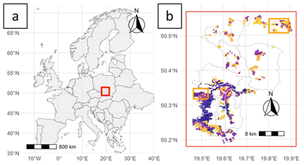
The research was conducted in southern Poland, in the Olkusz Forest District, representing contrasting site and soil conditions (Figure 1, Table 1). The sample plots were established to reflect the variability of growth conditions across the study area, starting from an exceptionally dry coniferous forest ecosystem near the Błędowska Desert, one of the most distinctive anthropogenic inland deserts in Central Europe. According to [26], this region contains the highest concentration of sandy-gravel deposits in the country. In the forested areas of this region, soils are predominantly classified as protic arenosols, often accompanied by aeolian dune formations. Vegetation includes xerothermic species adapted to arid and sun-exposed habitats. Poor soil conditions cause exceptionally low site productivity for Scots pine. Subsequent study plots were located in medium-fertile forest site conditions, including typical forest type for Scots pine, fresh coniferous forest and fresh mixed coniferous forest. The last sample plots were located on a fertile forest site type, fresh mixed forest. The dominant soil type in the area is brownic arenosol, making it one of the most fertile soil types found in forested areas in Poland [27].
Figure 1.
Geographic location and spatial characteristics of the study area. (a) Location of the study site within Europe. (b) Close-up view of the research area, with yellow rectangles indicating the established sample plots. Site index values are visualized using a color gradient, where dark blue denotes the lowest values and yellow denotes the highest values.
Table 1.
Key features of stand structure and site conditions across sampling locations.
Based on site index (SI) values, these plots were then grouped into three site productivity classes: low (SI < 20), medium (SI 21–30), and high (SI > 30) (Table 1). Site index (SI) was estimated using the model developed by [28] for Scots pine in Poland, which is based on the top height (TH) at a specified reference age. The TH was derived following the methodology outlined by [29]. To minimize the effect of stand age on root system development, all plots were established within the same age class (stand age between 42 and 99 years). The analyzed forest stands were subject to active management and characterized by an even-aged structure, reflecting standard silvicultural practices applied to Scots pine in Poland. Plots selected for analysis comprised a minimum of 70% Scots pine in species composition. From each SI group, soil samples were taken from excavations made to a depth of 2 m. Approximately one kilogram of organic and mineral soil was used for the subsequent analysis of carbon and nitrogen content in the soil. Before testing, the samples were cleaned of root fragments and dried. Finally, they were sieved through a 2-mm sieve. The content of elements in the soil was determined using a LECO CNS TruMack analyzer. In addition, the pH of the soils was measured by an electrochemical method using electrodes suspended in distilled water.
2.2. Fundamental Geophysical Concepts Behind the Use of GPR
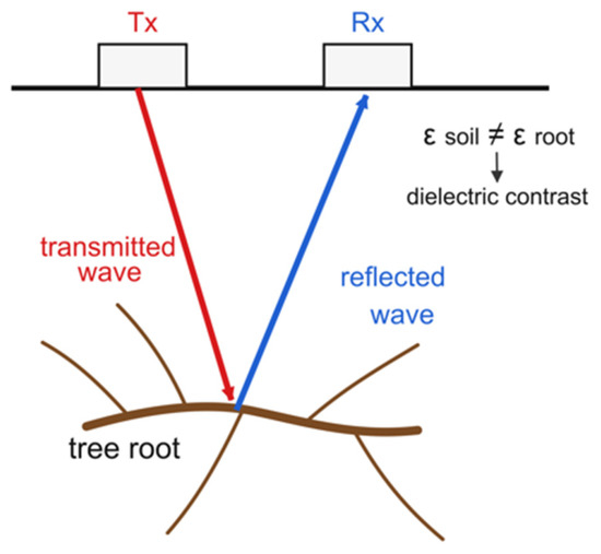
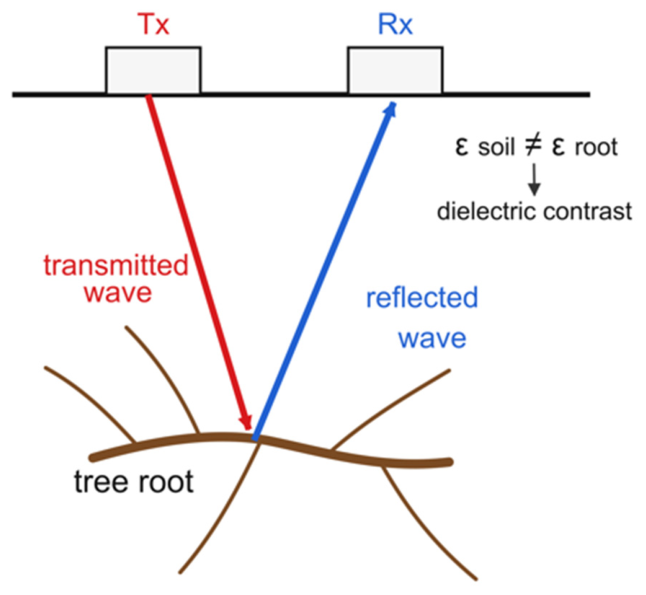
In this article, we present the measurement method using multichannel GPR for the non-invasive analysis of the root system architecture of Scots pine. The GPR system is designed to detect objects underground using microwaves. The antenna emits an electromagnetic signal toward the soil, and when the wave encounters a target, part of the energy is reflected, scattered, and subsequently received by the receiving antenna [30] (Figure 2).
Figure 2.
Principle of ground-penetrating radar (GPR) root detection: the transmitting antenna (Tx) emits an electromagnetic pulse into the soil, which is reflected by tree roots due to the dielectric permittivity contrast between root tissue and the surrounding soil and recorded by the receiving antenna (Rx).
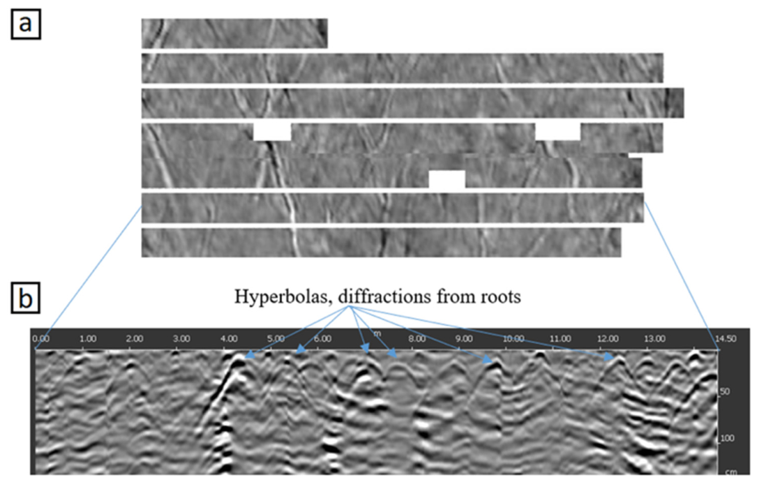
These reflections then appear in the scans as characteristic hyperbolas in cross-sectional profiles (Figure 3). The fundamental physical phenomenon enabling object detection with the GPR method is dielectric permittivity (ε), which defines the ability of a scanned material to store electric charge within an electric field.
Figure 3.
GPR-based visualization of Scots pine root systems and subsurface signal reflections. (a) Image created from GPR scanning of Scots pine roots, with white areas corresponding to tree trunks. (b) Cross-section through the soil showing signal reflections from root obstructions beneath the soil surface, caused by their dielectric contrast relative to the surrounding soil.
As the electromagnetic wave propagates through the soil and encounters a subsurface anomaly, a portion of its energy is reflected. The greater the dielectric contrast between adjacent materials, the stronger the reflected signal [31]. Ground-penetrating radar is specifically designed for imaging shallow subsurface objects in various environments, including forest soils. Due to the high water content of root tissues resulting from their role in water uptake, roots typically exhibit significantly higher dielectric permittivity compared to the surrounding soil matrix [32]. This contrast enables GPR to produce high-quality images in which root systems are distinguishable. The quality of the radar image also depends on the soil structure and type [33]. In sandy or podzolic soils, where electrical conductivity is low, signal attenuation is minimal. Therefore, GPR performance is significantly enhanced compared to that in compacted soils, especially those with a large amount of clay fractions [34].
2.3. Root System Scanning with Ground-Penetrating Radar
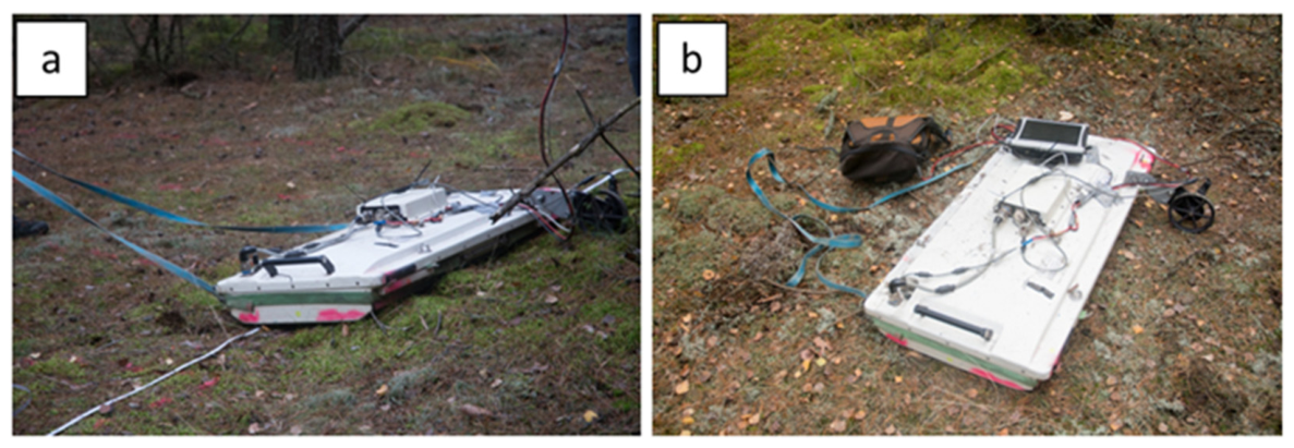
For the purpose of root system measurements, an advanced multichannel GPR system, specifically the Stream C system (IDS Georadar), was employed (Figure 4). The device, equipped with 34 measurement antennas (32 recording channels), enabled data acquisition to a maximum depth of approximately 3 m below the ground surface. With 32 channels distributed across a 1-m-wide array, the scanned area was sampled at 4 cm intervals, providing high spatial resolution. The use of dual-polarized antennas allowed for the simultaneous capture of longitudinal and transverse signals, resulting in a 4 cm resolution in both directions. Sample plots were surveyed statically with GNSS RTK, allowing for accurate georeferencing in the Polish national coordinate system (PUWG 2000, zone 7). GPR operates within the microwave frequency spectrum and, depending on the required depth and resolution, allows for the selection of frequencies ranging from a few MHz to as high as 4000 MHz for shallow, high-resolution applications. The selection of antenna frequency plays a critical role in determining data resolution and detection depth [35]; lower frequencies enable deeper subsurface penetration, whereas higher frequencies yield higher-resolution imagery. The chosen center frequency of 600 MHz for the wideband antennas offered an effective compromise between signal resolution and penetration depth. Based on classical resolution limits, a 600 MHz antenna operating in soil with an average relative dielectric permittivity of approximately εr = 9 cannot be assumed to reliably resolve subsurface targets smaller than about 4 cm solely on the basis of antenna frequency. However, moist roots embedded in a background medium with εr ≈ 9 may still produce detectable reflections because of their dielectric contrast with the surrounding soil, particularly under favorable soil conditions and root orientations.
Figure 4.
Field setup of the multichannel Stream C ground-penetrating radar system used for non-invasive root-system scanning under forest conditions. (a) Deployment of the Stream C GPR system equipped with a 34-antenna array during data acquisition. (b) Survey configuration showing the antenna arrangement and operational setup used in the field.
2.4. Scanning Transect
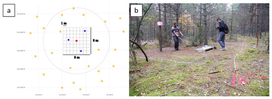
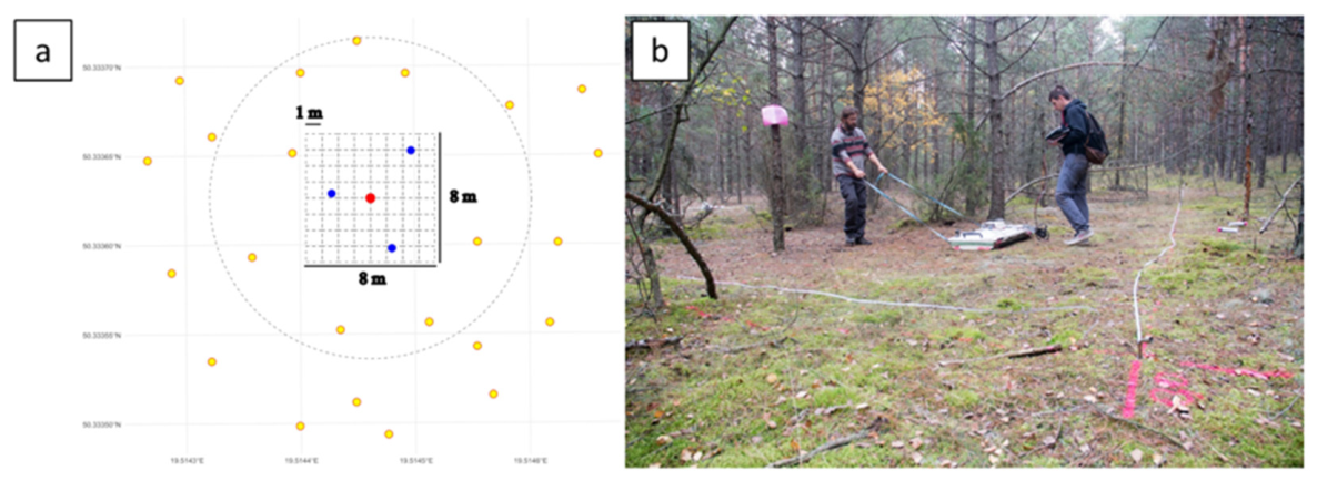
The scanning campaign was conducted between 28 and 29 October 2024. This period was preceded by two weeks with no recorded precipitation because higher soil moisture levels may introduce interference and noise into the acquired dataset [36]. GPR data acquisition was conducted on pre-selected plots that were cleared of understory vegetation, woody debris, and branches to minimize signal interference during scanning. Each study plot consisted of an 8 × 8 m grid centered on the measured tree (Figure 5); for the largest trees, the plot dimensions were extended to 12 × 12 m to capture the full extent of the root system. The plots were systematically scanned at 1-m intervals, corresponding to the maximum effective swath width of the GPR system. At least three Scots pine trees were measured in each plot.
Figure 5.
Layout and field organization of the research plot used for GPR data acquisition. (a) Plot layout used for root scanning. Blue dots indicate scanned trees, yellow dots indicate neighboring trees, and the red dot marks the plot center. Transects were spaced at 1 m intervals, forming an 8 × 8 m grid around the central tree. (b) Field photograph showing the marked plot boundaries and on-site organization during the GPR measurements.
2.5. Measurement of Above-Ground Tree Characteristics and Forest Inventory Data Collection
In order to characterize the features of the trees for which GPR measurements were made, circular plots with a radius of 10 m were established, including trees whose roots were scanned and those growing nearby. On these plots, basic dendrometric parameters were measured for each tree, including diameter at breast height (DBH), using a caliper, and tree height, using a Vertex hypsometer. The azimuth of each tree relative to the center of the plot was determined using a compass, along with the distance from the plot center; moreover, the azimuths of visible stumps were also recorded. In addition to field-based measurements, additional information on stand characteristics such as age, species composition, forest site type, and soil classification (type and subtype) was obtained from the Forest Data Bank (Table 1). To describe the structural attributes and site productivity of the analyzed stands, several key indicators were calculated. Stand density was assessed using the relative spacing index (RSI), which quantifies tree spacing relative to tree height and is commonly used to characterize intra-stand competition. The RSI was calculated using Equation (1) [37]:
where N is the number of trees per hectare and TH is the top height of trees in meters.
2.6. GPR Data Processing, Analysis, and Modeling
The multichannel GPR data processing workflow comprised four sequential stages: (I) field data acquisition and antenna configuration, (II) signal preprocessing and noise suppression, (III) three-dimensional reconstruction of coherent root-related reflections, and (IV) derivation of quantitative root-system metrics from the reconstructed volumes. In stage I, field data were acquired using a multichannel GPR system configured with vertical polarization, a center frequency of 600 MHz, a sampling step of 0.0403 m, and a sampling time of 0.104167 ns. These acquisition settings were used consistently throughout the survey to ensure comparability among profiles and trees. In stage II, signal preprocessing and noise suppression were carried out in IQMaps v. 15.2 software (IDS GeoRadar) using a standardized macro-based workflow designed to enhance the visibility of root-related reflections in complex radargrams. The preprocessing sequence began with time-zero correction, which aligned radar traces in time. This was followed by start-time shifting using a 40.0 m sliding window with trace averaging. Next, background removal was applied using a 20.0 m sliding window with trace averaging in order to suppress laterally continuous soil reflections. A time-domain band-pass filter (150–1500 MHz) was then used to isolate the frequency range most relevant for root detection and to reduce broadband noise. To further improve the detectability of root signatures, STC (SENSITIVITY TIME CONTROL) smoothed gain was applied using a 20.0 m sliding window with trace averaging and a smoothing time of 2.0 ns. Altogether, this preprocessing chain was intended to reduce soil-related clutter, suppress laterally continuous background reflections, and enhance the visibility of coherent hyperbolic reflections associated with roots. In stage III, the preprocessed data were used for the three-dimensional reconstruction of subsurface root-related reflections. To improve the geometric consistency of reflectors across adjacent profiles, time-domain migration was additionally applied in the cross-direction, using a migration width of 1.50 m. The same sequence of processing operations was applied throughout the dataset to stabilize the continuity of reflections in the reconstructed 3D volume prior to interpretation. Within this reconstructed volume, root objects were identified as coherent, spatially continuous reflection patterns observed across adjacent channels and parallel transects. These reflections were subsequently converted into three-dimensional point clouds representing individual root trajectories in the subsurface, and the resulting root positions were exported as XYZ coordinates in CSV format for further quantitative analysis. In stage IV, quantitative root-system characteristics were derived from the reconstructed root volumes for each tree. The two-dimensional range (2D-range) was defined as the plan-view area of the minimum bounding rectangle enclosing all detected root tips, calculated from the extreme X and Y coordinates. The three-dimensional range (3D-range) was defined as the volume of a rectangular prism with a horizontal base determined by the extreme X and Y coordinates and a height corresponding to the maximum detected rooting depth (Z). Both 2D-range and 3D-range therefore represent geometric descriptors derived directly from the spatial extent of roots detected by GPR, and should be interpreted as proxies of explored soil space, rather than as direct estimates of root biomass or total below-ground volume. Finally, the resulting root-system characteristics were compared across site productivity groups (low, medium, and high) in order to assess site-related variation in Scots pine root architecture.
To investigate how the volume of the root system of Scots pine derived from GPR data varied across different site and stand conditions, generalized additive models (GAMs) [38] were developed. GAMs were chosen due to their ability to flexibly model complex, non-linear relationships between root system metrics and environmental variables such as site type, stand age, or competition indices without the need to predefine the shape of these relationships [39]. This flexibility is particularly important in ecological research, where response patterns often deviate from simple linear assumptions. By applying spline smoothing, GAMs allow the data to determine the nature of the response while avoiding overfitting, which is especially valuable when working with field-derived datasets characterized by natural variability and noise. The GAM can be expressed in the following form (2):
where g(E(Y)) denotes the link function applied to the expected value of the response variable Y; β0 represents the intercept; and f1(x1), f2(x2), …, fp(xp) are smooth functions describing the relationships between the response and each explanatory variable x1, x2, …, xp.
g(E(Y)) = β0 + f1(x1) + f2(x2) + … + fp(xp)
This modeling approach enabled us to quantify the effect size of individual predictors and detect non-linear trends in root architecture across varying site conditions. Prior to model fitting, all explanatory variables were assessed for multicollinearity. Variance inflation factors (VIF) were calculated using functions compatible with the mgcv package in R (version 4.2.2, Vienna, Austria). Variables exceeding acceptable VIF thresholds were excluded to maintain model robustness and interpretability. Only statistically significant and non-redundant predictors were retained for inclusion in the final model. The GAMs were fitted using the mgcv package, employing restricted maximum likelihood (REML) estimation to determine smoothing parameters, following the methodology proposed by [40]. Among the tested predictors, diameter at breast height (DBH), relative spacing index (RSI), and site type were identified as the most influential variables shaping root system variability.
2.7. Data Validation
To validate the results obtained from the GPR data, individual tree roots that were clearly visible on the radargrams were manually excavated. The roots were successfully uncovered without damaging their structure, allowing for direct verification of their position and orientation. Next, the data from GPR and traditional measurements were compared using a Student’s t-test.
3. Results
3.1. Root Detection Results and Accuracy Assessment
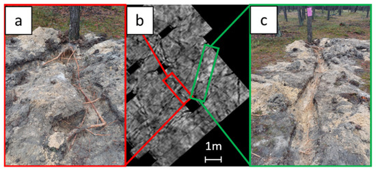
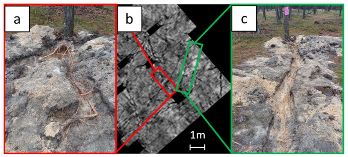
Using the Stream C multichannel GPR system (IDS GeoRadar), a total of 27 trees were scanned across three site productivity classes, resulting in the detection of 294 individual roots. Roots with diameters of approximately 1 cm were detected across all site types. To evaluate the accuracy of GPR-derived root geometry, 21 roots from 21 trees were selectively excavated, and their measured geometry was compared with corresponding radar-derived estimates (Figure 6). Mean root length measured in the field was 4.63 m compared with 4.71 m derived from GPR data, while the mean rooting depth was 0.26 m and 0.25 m, respectively. Paired Student’s t-tests were applied to assess potential systematic differences between the field measurements and GPR-based estimates. No statistically significant differences were detected for either root length or rooting depth (p > 0.05), indicating no clear systematic deviation between methods. For root length, the comparison was additionally supported by correlation analysis and Bland–Altman agreement analysis. Excavation- and GPR-derived root lengths were very strongly correlated (Pearson’s r = 0.987, p < 0.001), and Bland–Altman analysis showed a small mean bias of −0.073 (GPR − excavation), with 95% limits of agreement from −1.109 to 0.963. These results indicate good agreement between the two methods and confirm that GPR reproduced root length with no substantial systematic bias under field conditions.
Figure 6.
GPR-based detection of Scots pine roots and field verification using excavated root samples. (a) Photographic documentation of an excavated individual root used to verify the GPR results. (b) Transverse slice of the Scots pine root-system scan obtained using the multichannel Stream C GPR system on one of the study plots. (c) Photographic documentation of another excavated individual root used for validation of the GPR-based root detection.
Soil properties were found to significantly affect the radar signal quality. The clearest signals and greatest penetration depths, reaching up to 3 m, were recorded on low-productivity plots (dry coniferous forest) with coarse-textured dystric arenosols. These substrates, rich in quartz and low in electrical conductivity, provided ideal conditions for GPR scanning, producing deep and well-defined echograms. In contrast, high-productivity plots (fresh mixed forest) showed reduced radar penetration (approx. 2 m), associated with finer-textured soils containing higher clay and organic matter content, which are known to attenuate electromagnetic waves. The elevated electrical conductivity of clay-rich soils further decreased the signal clarity and propagation depth. Notably, radar wave velocity varied between sites, measured at 13 cm/ns on the poorest sandy soils and 11 cm/ns on the most fertile plots, highlighting the influence of soil composition on wave behavior. Despite these variations, root detection was successful across all site types.
3.2. Differences in GPR-Derived Root Spatial Metrics Among Site Classes
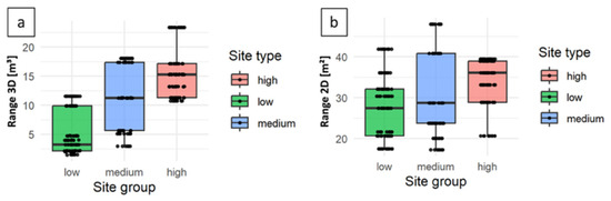
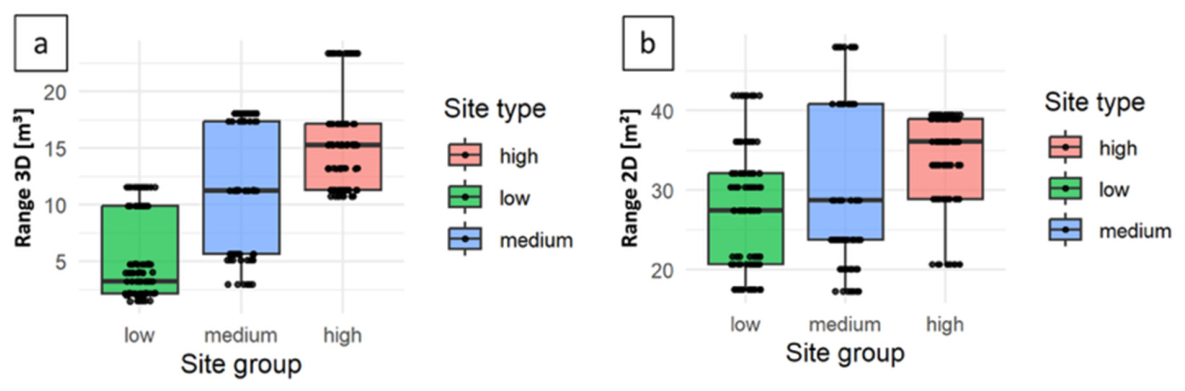
We compared the two-dimensional (2D) range and the three-dimensional (3D) range of Scots pine root systems across site types (Figure 7). Mean 3D-range increased from approximately 3 m3 on low-productivity sites to 11 m3 on medium-productivity sites and 15 m3 on high-productivity sites. Mean 2D-range also increased along the same gradient, from 27 m2 to 29 m2 and 36 m2, respectively. Thus, both metrics increased with site fertility, but the pattern was much more pronounced for the 3D-range, which showed substantially larger between-group contrasts than the 2D-range.
Figure 7.
Variation in the spatial extent of Scots pine root systems across site condition classes, defined as low, medium, and high, as determined from GPR surveys. (a) Variation in 3D range. (b) Variation in 2D range.
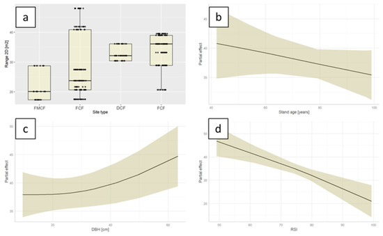
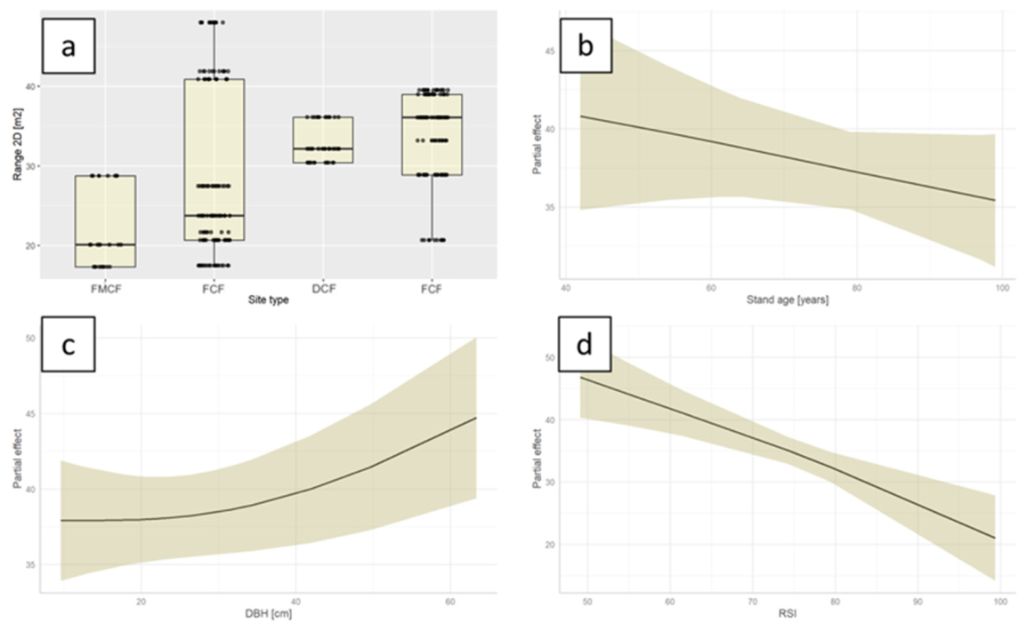
The developed GAM identified the effects of stand- and site-related attributes on the two-dimensional (2D) root-system range (Figure 8a–d). Observed values of the two-dimensional root-system range differed among forest site types (Figure 8a). The mean 2D-range was lowest in the fresh mixed coniferous forest (FMCF; 20 m2) and increased slightly in the fresh coniferous forest (FCF; 24 m2), where several high-value outliers were also observed. Higher mean values were predicted for the dry coniferous forest (DCF; >30 m2). The fresh mixed forest (FMF) exhibited the greatest 2D-range, with a mean of 36 m2, although several low outliers were also observed. The interquartile ranges indicated greater variability in the medium- and high-productivity site types than in the poorest sites. The partial effect of stand age was negative and approximately linear, with the predicted 2D-range values decreasing gradually across the observed age gradient (Figure 8b). Diameter at breast height (DBH) showed a positive, non-linear effect: model predictions remained relatively stable at lower DBH values, but increased more rapidly above approximately 30 cm (Figure 8c). The relative spacing index (RSI) exhibited a consistently negative effect, with the predicted 2D-range declining across the observed range of RSI values (Figure 8d).
Figure 8.
GAM-predicted variation in the two-dimensional root-system range (2D range) of Scots pine across forest site types and along stand- and tree-level predictors, as estimated by the GAM. (a) Observed 2D range by forest site type: FMCF, fresh mixed coniferous forest; FCF, fresh coniferous forest; DCF, dry coniferous forest; and FMF, fresh mixed forest. (b) GAM-fitted partial effect of stand age on 2D range, (c) diameter at breast height, (d) relative spacing index. Shaded areas represent 95% confidence intervals.
Model performance was satisfactory, as the GAM achieved a robust goodness-of-fit, with an adjusted R2 = 0.469 and a percentage deviance explained of 48.1%, indicating substantial explanatory power.
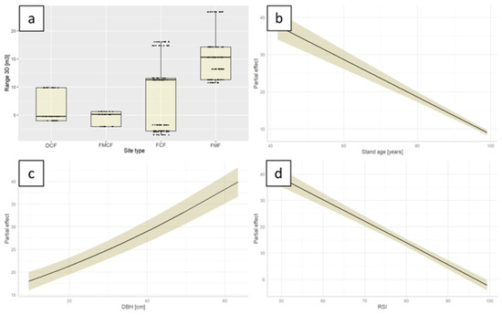
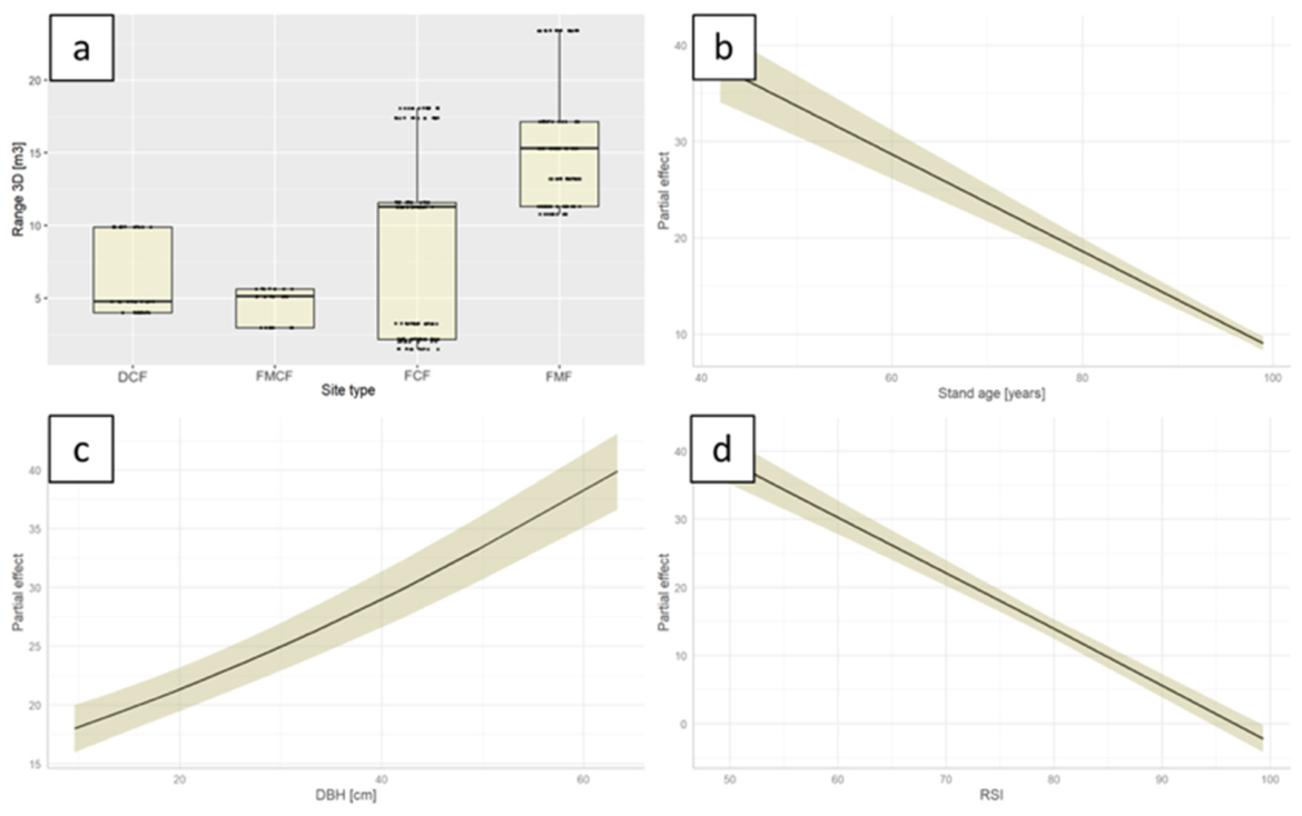
The GAM analysis revealed associations between stand- and site-related attributes and variation in the three-dimensional (3D) root-system range (Figure 9a–d). Predicted 3D-range varied among forest site types (Figure 9a). The lowest mean values were predicted for the dry coniferous forest (DCF; 5 m3), with upper values reaching approximately 10 m3. The mean was only slightly higher in the fresh mixed coniferous forest (FMCF), which also showed relatively low variability. In the fresh coniferous forest (FCF), the mean predicted 3D-range was approximately 11 m3, although some low values occurred around 2.5 m3. The highest mean 3D-range was predicted for the fresh mixed forest (FMF), at approximately 15 m3. The interquartile ranges indicated increasing variability in 3D-range toward more productive site types. The partial effect of stand age was negative and approximately linear, with the predicted 3D-range decreasing across the observed age gradient (Figure 9b). Diameter at breast height (DBH) showed a positive effect, with the predicted 3D-range increasing monotonically across the observed DBH range (Figure 9c). The relative spacing index (RSI) exhibited a negative effect, with predicted 3D-range decreasing as RSI increased (Figure 9d).
Figure 9.
GAM-predicted variation in the three-dimensional root-system range (3D range) of Scots pine across forest site types and along stand- and tree-level predictors, as estimated by the GAM. (a) Observed 3D range by forest site type: FMCF, fresh mixed coniferous forest; FCF, fresh coniferous forest; DCF, dry coniferous forest; and FMF, fresh mixed forest. (b) GAM-fitted partial effect of stand age on 3D range, (c) diameter at breast height, and (d) relative spacing index. Shaded areas represent 95% confidence intervals.
Model performance was solid, as the GAM achieved a robust goodness-of-fit, with an adjusted R2 = 0.811 and percentage deviance explained (81.5%), indicating substantial explanatory power. The generalized additive model identified a significant effect of site type on the total 3D root-system volume of Scots pine. Generally, the 3D root-system range increased along the fertility gradient. The largest contrasts occurred between the poorer sites (FMCF/DCF) and the more fertile ones (FCF/FMF). Overall, the model supports a strong, positive association between site fertility and below-ground 3D-range.
4. Discussion
Knowledge of forest tree root architecture has traditionally been derived from invasive approaches such as excavation, trenching, and soil coring. While these methods can provide detailed structural information, they are destructive, labor-intensive, and typically restrict sample sizes and spatial replication, thereby limiting inference at the stand scale. In addition, fine and highly branched lateral roots, which are often most relevant for resource uptake and plastic responses, are particularly prone to damage and undercounting during excavation, introducing systematic bias into reconstructed architectures. These constraints motivate the use of non-invasive remote sensing methods capable of capturing below-ground structure with sufficient spatial sampling for comparative analyses. In this context, our findings indicate that multichannel GPR provides a practical, non-invasive means of quantifying lateral root-system geometry at operational plot scales. In contrast to earlier single-channel applications constrained by sparse sampling and limited resolution [41,42], multichannel acquisition delivered dense coverage that supported consistent mapping of lateral root networks and the derivation of robust geometric descriptors (2D-range and 3D-range). This shift from “single-tree feasibility mapping” toward stand-level comparative root phenotyping represents a key methodological contribution of the present study. More broadly, the study positions below-ground structural sensing within the wider frontier of forest remote sensing by showing how spatially explicit root traits can support stand-level phenotyping and future integration with above-ground remote sensing products.
Across the investigated productivity gradient, both 2D-range and 3D-range varied systematically among site types, with the strongest contrasts expressed in 3D-range. This pattern suggests that improved site conditions translate primarily into an expansion of the detectable rooting envelope in the vertical–volumetric dimension rather than a proportional increase in horizontal spread. The GAM results further indicate that tree size (DBH) is positively associated with rooting-envelope volume, whereas stand structure (RSI) and stand age are associated with lower predicted values, consistent with competitive limitation and ontogenetic shifts in below-ground allocation. Notably, model performance differed between the two response variables, with a substantially higher adjusted R2 for 3D-range than for 2D-range, indicating that the current predictor set captures vertical–volumetric variation more effectively than planar spread. The lower explanatory power for 2D-range is plausibly related to additional, unmeasured drivers of lateral expansion that are not represented by DBH, age, RSI, and site class alone. Variables that directly characterize above-ground space occupation and site productivity, such as crown size or crown volume, canopy projection area, or stand-level site index, could help account for this residual variability and improve the interpretability of 2D-range patterns. Importantly, this points to a broader remote-sensing opportunity: below-ground geometric descriptors derived from multichannel GPR could be analyzed jointly with above-ground structural metrics from ALS, TLS, UAV photogrammetry, or airborne laser scanning in order to better explain how rooting architecture co-varies with canopy form, stand density, and site conditions. In this sense, the present study not only characterizes root-system variation across site types, but also highlights the potential of multichannel GPR to fill a persistent observational gap in forest remote sensing, where the below-ground structure remains far less accessible than above-ground traits.
These results are broadly consistent with excavation-based evidence that Scots pine exhibits strong below-ground plasticity in response to edaphic conditions. Our results also accord with the classic work of [43], who, based on extensive root excavations, documented the capacity of Scots pine to adjust its below-ground architecture to changing edaphic conditions. In particular, trees growing on sandy, well-drained soils were shown to develop a pronounced taproot accompanied by an extensive lateral root network, a pattern further facilitated by the low mechanical resistance of coarse-textured substrates [44]. Easy root penetration and limited physical constraints in dystric arenosols promote extensive lateral exploration, which may explain why trees on dry coniferous forest sites reached nearly the highest values of the 2D-range despite low site fertility. Conversely, the stronger site contrasts in the 3D-range indicate that the depth-related component of the rooting envelope is particularly sensitive to site conditions, consistent with the notion that deeper exploitation becomes more feasible where the soil physical conditions allow deeper penetration and sustained resource availability. From a methodological perspective, the relevance of this pattern extends beyond Scots pine ecology alone. Because below-ground structure has remained one of the least observed components of forest organization, the ability to recover site-related variation in rooting envelopes at stand scale positions multichannel GPR within an emerging frontier of below-ground forest sensing. Rather than serving only as a tool for local root detection, it can contribute spatially explicit root traits that are potentially comparable across stands, site classes, and management contexts, thereby extending forest remote sensing toward a more integrated representation of whole-tree structure.
Methodologically, the central innovation of our approach lies not only in the use of a multichannel array itself, but in the combination of dense, geometrically stable acquisition, standardized preprocessing, and three-dimensional reconstruction that together enable stand-scale inference on lateral root architecture. In contrast to many earlier GPR applications conducted in relatively accessible managed settings (e.g., parks or botanical gardens) [10], our study demonstrates the feasibility of root characterization in forest environments spanning a broad gradient of productivity and soil conditions. Earlier GPR studies of tree roots repeatedly reported practical limitations, including high signal noise, low-contrast radargrams that are difficult to interpret, time-consuming acquisition, and reduced detectability of small roots and roots with unfavorable orientation, especially vertical structures [41,42,45,46]. These constraints are consistent with the broader root-GPR literature, which emphasizes that detectability is strongly dependent on soil properties and root orientation, with reduced performance in conductive, heterogeneous, or water-saturated substrates and limited sensitivity to vertically oriented roots, including the taproot, which contributes substantially to mechanical anchorage [47]. Because our ecological interpretation focuses on laterally oriented, resource-acquiring roots that are primarily responsible for water and nutrient uptake [48], this limitation is unlikely to compromise the central inferences of the study, although it may bias volumetric descriptors in the vertical dimension. A fuller accounting of below-ground biomass would therefore benefit from complementary approaches, including predictive taproot models calibrated against targeted ground truth (e.g., selective coring/augering or limited excavations). Within this context, multichannel surveying mitigates several well-known limitations of single-channel GPR by increasing the spatial sampling density, improving continuity across adjacent profiles, and reducing the likelihood of discontinuous or missed reflections when mapping lateral root networks. However, these gains in coverage and interpretability do not remove uncertainty; rather, they make transparent and repeatable processing even more important. Steps such as time-zero correction, background removal, filtering and gain adjustment, migration, and time-to-depth conversion directly control the visibility and geometric consistency of root-related reflections and the stability of the derived metrics [49]. Recent methodological studies likewise demonstrate that workflow choice strongly affects the interpretability and metric stability of GPR-derived root attributes [49]. With respect to accuracy, published validation studies commonly report close agreement between GPR-derived and field-measured geometry for coarse roots above a detectable diameter threshold, often around 1–2 cm, whereas detectability and depth accuracy deteriorate for smaller roots and in more conductive soils [49,50]. The effective accuracy and interpretability of GPR images are also influenced by the selected antenna frequency. Higher frequencies provide improved spatial resolution but typically allow detection only at shallower depths because of stronger signal attenuation in the ground, whereas lower frequencies increase penetration depth at the cost of reduced resolution and lower sensitivity to small targets. Therefore, frequency selection represents a practical compromise between resolving fine root features and achieving sufficient depth coverage for the target rooting zone. In this study, the use of a 600 MHz configuration follows common practice in tree-root investigations and is consistent with published GPR applications to below-ground root mapping, particularly in coarse-textured soils where penetration and resolution can be balanced effectively. Depth-related metrics remain conditional on site-specific EM wave velocity and attenuation, so reporting the adopted velocity model and soil context is essential for reproducible comparisons across site types. This allows for the effective detection of roots with diameters around 1 cm and of roots at depths reaching approximately 3 m under favorable coarse-grained soil conditions. Nonetheless, Scots pine in Poland occurs predominantly on sandy and gravelly substrates shaped by post-glacial geomorphology [51], which are generally favorable for GPR signal penetration [52]. This pattern aligns with our validation strategy and supports interpreting our metrics as reliable descriptors of lateral coarse-root architecture under the soil conditions represented in the study.
A key implication of these findings is that multichannel GPR should be viewed not merely as a specialized root-detection tool, but as a component of integrated forest remote sensing workflows. At present, forest structure is typically characterized above-ground using ALS, TLS, LiDAR, or UAV-based products, whereas below-ground organization remains largely unobserved. By providing spatially explicit descriptors of the explored soil volume and lateral rooting extent, multichannel GPR offers a way to connect these two domains and to support joint analyses of canopy architecture, stand structure, and root-system geometry. Such integration could improve models linking crown size, canopy projection area, competition intensity, and site productivity with below-ground allocation patterns, and could ultimately support more mechanistic stand-level phenotyping. This is particularly relevant because one of the missing frontiers in forest remote sensing is the ability to describe whole-tree architecture rather than only its above-ground component.
The multichannel configuration also has clear implications for scalability and operational forest monitoring. By acquiring multiple channels simultaneously, such systems markedly increase the survey efficiency and spatial sampling density, enabling rapid coverage of larger plots while maintaining stable and repeatable survey geometry under realistic forest conditions. This is difficult to achieve with traditional single-channel transects, especially in uneven or densely vegetated terrain. The Stream C configuration further improves field applicability through dual-polarization channels, which support single-directional scanning when orthogonal grid layouts are impractical, and through variable-offset measurements that provide multiple transmitter–receiver separations within a single pass. These features strengthen the repeatability, precision, and operational relevance of GPR-based surveys in forest environments. Although GPR will not replace area-wide airborne methods for large-scale mapping, it can serve as an operational plot-scale technology for repeated monitoring, calibration studies, and the development of transferable below-ground indicators that complement broader Earth observation frameworks. In the context of increasingly frequent drought events in Europe [24,53,54], such non-invasive monitoring of root-system architecture may support assessments of site-related adaptive capacity and provide useful information for climate-smart silviculture and restoration planning [55].
5. Conclusions
In this study, we demonstrated that multichannel Stream C GPR enables the non-invasive, high-resolution quantification of Scots pine root-system architecture across forest stands differing in site productivity. By deriving geometric metrics of the two-dimensional (2D) and three-dimensional (3D) root-system range from three-dimensional radar volumes and relating them to stand- and tree-level variables using generalized additive models, we showed that variation in below-ground architecture is systematically associated with site fertility, stand density, and tree size. Rooting-envelope volume increased along the site fertility gradient and with diameter at breast height, while decreased with stand age and relative spacing index. The close agreement between radar-derived root patterns and selective excavations confirms the reliability of multichannel GPR for characterizing lateral root networks under field conditions. Overall, our results indicate that multichannel GPR provides robust, transferable below-ground metrics that can support forest monitoring and modeling efforts, and offer a methodological basis for incorporating root-system traits into studies of forest structure and management under changing environmental conditions.
Author Contributions
Conceptualization, L.T.-C.; Methodology, L.T.-C., B.N., J.M. and F.B.; Software, J.M. and A.Z.; Validation, A.Z. and F.B.; Formal analysis, L.T.-C., J.M. and F.B.; Investigation, F.B. and I.P.; Resources, J.M. and L.T.-C.; Data curation, L.T.-C.; J.M. and I.P.; Writing—original draft preparation, F.B., L.T.-C. and A.Z.; Writing—review and editing, F.B.; Project administration, L.T.-C.; Funding acquisition, L.T.-C. and J.S. All authors have read and agreed to the published version of the manuscript.
Funding
This research was carried out under the project “Use of GPR with 3D scanner to measure root system variability of Scots pine trees” (No 2024/08/X/NZ9/00152) funded by the National Science Center, Poland.
Data Availability Statement
The raw data supporting the conclusions of this article will be made available by the authors on request.
Conflicts of Interest
The authors declare no conflicts of interest.
References
- Nadezhdina, N.; Čermák, J. Instrumental methods for studies of structure and function of root systems of large trees. J. Exp. Bot. 2003, 54, 1511–1521. [Google Scholar] [CrossRef] [Scilit]
- Freschet, G.T.; Pagès, L.; Iversen, C.M.; Comas, L.H.; Rewald, B.; Roumet, C.; Klimešová, J.; Zadworny, M.; Poorter, H.; Postma, J.A.; et al. A starting guide to root ecology: Strengthening ecological concepts and standardising root classification, sampling, processing and trait measurements. New Phytol. 2021, 232, 973–1122. [Google Scholar] [CrossRef] [Scilit]
- Butnor, J.R.; Doolittle, J.A.; Johnsen, K.H.; Samuelson, L.; Stokes, T.; Kress, L. Utility of ground-penetrating radar as a root-biomass survey tool in forest systems. Soil Sci. Soc. Am. J. 2003, 67, 1607–1615. [Google Scholar] [CrossRef] [Scilit]
- Bijak, S.; Zasada, M. Oszacowanie biomasy korzeni w drzewostanach sosnowych Borów Lubuskich. Sylwan 2007, 12, 21–29. [Google Scholar] [CrossRef]
- Annighöfer, P.; Mund, M.; Seidel, D.; Ammer, C.; Ameztegui, A.; Balandier, P.; Bebre, I.; Collet, C.; Coll, L.; Hamm, T.; et al. Examination of above-ground attributes to predict below-ground biomass of young trees. For. Ecol. Manag. 2022, 505, 119942. [Google Scholar] [CrossRef] [Scilit]
- Zhao, Y.; Zhang, L.; Lei, S.; Liao, L.; Zhang, C. Machine-learning-based prediction of below-ground biomass from above-ground biomass and soil properties. Environ. Model. Softw. 2025, 185, 106313. [Google Scholar] [CrossRef] [Scilit]
- Ragland, C.J.; Shih, K.Y.; Dinneny, J.R. Choreographing root architecture and rhizosphere interactions through synthetic biology. Nat. Commun. 2024, 15, 1370. [Google Scholar] [CrossRef] [Scilit]
- Rajchel, B. Próba wykorzystania georadaru do badań płytkich zmian antropogenicznych w podłożu. Biul. Państw. Inst. Geol. 2011, 446, 225–232. [Google Scholar]
- Hruška, J.; Čermák, J.; Šustek, S. Mapping tree root systems with ground-penetrating radar. Tree Physiol. 1999, 19, 125–130. [Google Scholar] [CrossRef] [Scilit] [PubMed]
- Nichols, P.; McCallum, A.; Lucke, T. Using ground-penetrating radar to locate and categorise tree roots under urban pavements. Urban For. Urban Green. 2017, 27, 9–14. [Google Scholar] [CrossRef] [Scilit]
- Hugenschmidt, J.; Kay, S. Unmasking adaptation of tree root structure in agroforestry systems in Switzerland using GPR. Geoderma Reg. 2023, 34, e00659. [Google Scholar] [CrossRef] [Scilit]
- Butnor, J.; Doolittle, J.A.; Kress, L.; Cohen, S.; Johnsen, K.H. Use of ground-penetrating radar to study tree roots in the southeastern United States. Tree Physiol. 2001, 21, 1269–1278. [Google Scholar] [CrossRef] [Scilit]
- Alani, A.M.; Lantini, L. Recent advances in tree root mapping and assessment using non-destructive testing methods: A focus on ground penetrating radar. Surv. Geophys. 2019, 41, 605–646. [Google Scholar] [CrossRef] [Scilit]
- Kurowska, E.E.; Kasztelan, A.; Czerniak, A. Test skuteczności badań systemów korzeniowych sosny zwyczajnej i sosny żółtej georadarem wyposażonym w antenę 750 MHz. Pol. J. For. 2021, 20, 199–206. [Google Scholar] [CrossRef] [Scilit]
- Lantini, L.; Tosti, F.; Giannakis, I.; Zou, L.; Benedetto, A.; Alani, A.M. An enhanced data-processing framework for mapping tree root systems using ground penetrating radar. Remote Sens. 2020, 12, 3417. [Google Scholar] [CrossRef] [Scilit]
- Tymińska-Czabańska, L.; Polak, M.; Miszczyszyn, J.; Dąbrowski, M.; Socha, J. First application of multichannel GPR for root system variability analysis in Scots pine forests. Ecol. Indic. 2025, 179, 114282. [Google Scholar] [CrossRef] [Scilit]
- Fabregat, I.; Gutiérrez, F.; Roqué, C.; Zarroca, M.; Linares, R.; Comas, X.; Guerrero, J.; Carbonel, D. Subsidence mechanisms and sedimentation in alluvial sinkholes inferred from trenching and ground penetrating radar (GPR). Quat. Int. 2019, 519, 100–115. [Google Scholar] [CrossRef] [Scilit]
- Potępa, B.; Szynkiewicz, A.; Udyrysz-Kraweć, M. GPR survey for fir (Abies alba) and spruce (Picea abies) root systems in different locations in the Western Carpathians Mountains (Poland). J. Geol. Resour. Eng. 2018, 6, 194–209. [Google Scholar] [CrossRef] [Scilit]
- Meier, I.C.; Brunner, I.; Godbold, D.L.; Helmisaari, H.-S.; Ostonen, I.; Soudzilovskaia, N.A.; Prescott, C.E. Roots and rhizospheres in forest ecosystems: Recent advances and future challenges. For. Ecol. Manag. 2018, 430, 213–233. [Google Scholar] [CrossRef] [Scilit]
- Brunner, I.; Godbold, D. Tree roots in a changing world. J. For. Res. 2007, 12, 78–82. [Google Scholar] [CrossRef] [Scilit]
- El Amrani, B. Exploring the importance of root architecture plasticity in plant adaptation to environmental constraints. Plant Species Biol. 2023, 38, 234–244. [Google Scholar] [CrossRef] [Scilit]
- La Bella, G.; Acosta, A.T.R.; Jucker, T.; Bricca, A.; Ciccarelli, D.; Stanisci, A.; Migliore, M.; Carboni, M. Below-ground traits, rare species and environmental stress regulate the biodiversity–ecosystem function relationship. Funct. Ecol. 2024, 38, 2378–2394. [Google Scholar] [CrossRef] [Scilit]
- Hauke-Kowalska, M.; Borowiak, E.; Jagiełło, R. Effect of drought on variability of cones and seeds of Pinus sylvestris L. Sylwan 2022, 166, 159–170. [Google Scholar] [CrossRef]
- Socha, J.; Hawryło, P.; Tymińska-Czabańska, L.; Reineking, B.; Lindner, M.; Netzel, P.; Grabska-Szwagrzyk, E.; Vallejos, R.; Reyer, C.P. Higher site productivity and stand age enhance forest susceptibility to drought-induced mortality. Agric. For. Meteorol. 2023, 341, 109680. [Google Scholar] [CrossRef] [Scilit]
- Tymińska-Czabańska, L.; Janiec, P.; Hawryło, P.; Ślopek, J.; Zielonka, A.; Netzel, P.; Janczyk, D.; Socha, J. Modeling the effect of stand and site characteristics on the probability of mistletoe infestation in Scots pine stands using remote sensing data. For. Ecosyst. 2024, 11, 100191. [Google Scholar] [CrossRef] [Scilit]
- Rahmonow, O. Procesy zarastania Pustyni Błędowskiej; Wydział Nauk o Ziemi Uniwersytetu Śląskiego: Sosnowiec, Poland, 1999. [Google Scholar]
- Piwowarski, B. Vascular Plants of the Jędrzejów Plateau (Małopolska Upland); Institute of Botany of the Jagiellonian University: Kraków, Poland, 2014. [Google Scholar]
- Socha, J.; Hawryło, P.; Leszczyński, K.; Tymińska-Czabańska, L. Height growth and site index models for main forest forming tree species in Poland. Sylwan 2023, 167, 617–632. [Google Scholar] [CrossRef]
- Hawryło, P.; Socha, J.; Wężyk, P.; Ochał, W.; Krawczyk, W.; Miszczyszyn, J.; Tymińska-Czabańska, L. How to adequately determine the top height of forest stands based on airborne laser scanning point clouds. For. Ecol. Manag. 2024, 551, 121528. [Google Scholar] [CrossRef] [Scilit]
- Webster, J.G.; Catapano, I.; Gennarelli, G.; Ludeno, G.; Soldovieri, F.; Persico, R. Ground-penetrating radar: Operation principle and data processing. In Wiley Encyclopedia of Electrical and Electronics Engineering; Wiley: Hoboken, NJ, USA, 2019. [Google Scholar] [CrossRef] [Scilit]
- Kuznetsov, A.I.; Miroshnichenko, A.E.; Brongersma, M.L.; Kivshar, Y.S.; Luk’yanchuk, B. Optically resonant dielectric nanostructures. Science 2016, 354, aag2472. [Google Scholar] [CrossRef] [Scilit]
- Cseresnyés, I.; Füzy, A.; Kabos, S.; Kelemen, B.; Rajkai, K.; Takács, T. Monitoring plant water uptake by measuring root dielectric properties on a fine timescale: Diurnal changes and response to leaf excision. Plant Methods 2024, 20, 5. [Google Scholar] [CrossRef] [Scilit] [PubMed]
- Ruan, W.; Liu, B.; Liu, H.; Dong, H.; Sui, Y. Ground penetrating radar (GPR) identification method for agricultural soil stratification in a typical mollisols area of Northeast China. Chin. Geogr. Sci. 2023, 33, 664–678. [Google Scholar] [CrossRef] [Scilit]
- Doolittle, J.A.; Collins, M.E. Use of soil information to determine application of ground-penetrating radar. J. Appl. Geophys. 1995, 33, 101–108. [Google Scholar] [CrossRef]
- Guo, L.; Chen, J.; Cui, X.; Fan, B.; Lin, H. Application of ground-penetrating radar for coarse root detection and quantification: A review. Plant Soil 2013, 362, 1–23. [Google Scholar] [CrossRef] [Scilit]
- Wróbel, A.; Ortyl, Ł. Georadar and thermovision method for the acquisition of geodata on subsurface voids. Arch. Fotogram. Kartogr. I Teledetekcji 2007, 17B, 59–68. [Google Scholar]
- Socha, J.; Hawryło, P.; Pierzchalski, M.; Stereńczak, K.; Krok, G.; Wężyk, P.; Tymińska-Czabańska, L. An allometric area-based approach—A cost-effective method for stand volume estimation based on ALS and NFI data. Forestry 2020, 93, 344–358. [Google Scholar] [CrossRef] [Scilit]
- Hastie, T.J.; Tibshirani, R.J. Generalized Additive Models; CRC Press: Boca Raton, FL, USA, 1990. [Google Scholar]
- Viet, H.D.X.; Tymińska-Czabańska, L.; Socha, J. Modeling the effect of stand characteristics on oak volume increment in Poland using generalized additive models. Forests 2023, 14, 123. [Google Scholar] [CrossRef] [Scilit]
- Wood, S.N. Fast stable restricted maximum likelihood and marginal likelihood estimation of semiparametric generalized linear models. J. R. Stat. Soc. Ser. B Stat. Methodol. 2011, 73, 3–36. [Google Scholar] [CrossRef] [Scilit]
- Butnor, J.R.; Pruyn, M.L.; Shaw, D.C.; Harmon, M.E.; Mucciardi, A.N.; Ryan, M.G. Detecting defects in conifers with ground penetrating radar: Applications and challenges. For. Pathol. 2009, 39, 309–322. [Google Scholar] [CrossRef] [Scilit]
- Trinks, I.; Hinterleitner, A.; Neubauer, W.; Nau, E.; Löcker, K.; Wallner, M.; Gabler, M.; Filzwieser, R.; Wilding, J.; Schiel, H.; et al. Large-area high-resolution ground-penetrating radar measurements for archaeological prospection. Archaeol. Prospect. 2018, 25, 279–292. [Google Scholar] [CrossRef] [Scilit]
- Köstler, J.; Brückner, E.; Bibelriether, H. Wurzelatlas Mitteleuropäischer Waldbäume und Sträucher; Paul Parey: Hamburg/Berlin, Germany, 1968. [Google Scholar]
- Kramer-Walter, K.R.; Bellingham, P.J.; Millar, T.R.; Smissen, R.D.; Richardson, S.J.; Laughlin, D.C. Root traits are multidimensional: Specific root length is independent from root tissue density and the plant economic spectrum. J. Ecol. 2016, 104, 1299–1310. [Google Scholar] [CrossRef] [Scilit]
- Rhee, J.-Y.; Park, K.-T.; Cho, J.-W.; Lee, S.-Y. A study of the application and the limitations of GPR investigation on underground survey of Korean expressways. Remote Sens. 2021, 13, 1805. [Google Scholar] [CrossRef] [Scilit]
- Hirano, Y.; Dannoura, M.; Aono, K.; Igarashi, T.; Ishii, M.; Yamase, K.; Makita, N.; Kanazawa, Y. Limiting factors in the detection of tree roots using ground-penetrating radar. Plant Soil 2009, 319, 15–24. [Google Scholar] [CrossRef] [Scilit]
- Sinacore, K.; Hall, J.S.; Potvin, C.; Royo, A.A.; Ducey, M.J.; Ashton, M.S. Unearthing the hidden world of roots: Root biomass and architecture differ among species within the same guild. PLoS ONE 2017, 12, e0185934. [Google Scholar] [CrossRef] [Scilit]
- Gilroy, S.; Jones, D. Through form to function: Root-hair development and nutrient uptake. Trends Plant Sci. 2000, 5, 56–60. [Google Scholar] [CrossRef] [Scilit] [PubMed]
- Rocha, A.A.; Borges, W.R.; Giannoccaro, V.H.; Ferreira Rodrigues de Oliveira e Sousa, F.R.; Ramalho Maciel, S.T.; de Almeida Rocha, J.; Baiocchi Jacobson, T.K. Imaging tree root systems using ground penetrating radar (GPR) data in Brazil. Front. Earth Sci. 2024, 12, 1353572. [Google Scholar] [CrossRef] [Scilit]
- Bi, B.; Shen, L.; Zhang, P.; Huang, X.; Jin, Q.X.T. GPR Missing Data Recovery via Deep Unfolding Network with Mask Guidance. In Proceedings of the 2023 8th International Conference on Signal and Image Processing (ICSIP), Wuxi, China, 8–10 July 2023; pp. 838–842. [Google Scholar] [CrossRef] [Scilit]
- Mycielska-Dowgiałło, E. Estimates of late-glacial and Holocene aeolian activity in Belgium, Poland and Sweden. Boreas 1993, 22, 165–170. [Google Scholar] [CrossRef] [Scilit]
- Castro, K.C.P.L.; Cunha, L.S.; Sousa, A.C.A.; Nogueira, P.V.; Borges, W.R. Influence of the sand–clay ratio of the burial material of forensic targets on ground-penetrating radar (GPR) responses: Comparison of dry and rainy season data. Front. Earth Sci. 2024, 12, 1305496. [Google Scholar] [CrossRef] [Scilit]
- Spinoni, J.; Vogt, J.V.; Naumann, G.; Barbosa, P.; Dosio, A. Will drought events become more frequent and severe in Europe? Int. J. Climatol. 2018, 38, 1718–1736. [Google Scholar] [CrossRef] [Scilit]
- Pińskwar, I.; Choryński, A.; Kundzewicz, Z.W. Severe drought in the spring of 2020 in Poland—More of the same? Agronomy 2020, 10, 1646. [Google Scholar] [CrossRef] [Scilit]
- Bassirirad, H. Kinetics of nutrient uptake by roots: Responses to global change. New Phytol. 2000, 147, 155–169. [Google Scholar] [CrossRef] [Scilit]

Disclaimer/Publisher’s Note: The statements, opinions and data contained in all publications are solely those of the individual author(s) and contributor(s) and not of MDPI and/or the editor(s). MDPI and/or the editor(s) disclaim responsibility for any injury to people or property resulting from any ideas, methods, instructions or products referred to in the content. |
© 2026 by the authors. Licensee MDPI, Basel, Switzerland. This article is an open access article distributed under the terms and conditions of the Creative Commons Attribution (CC BY) license.