


Highlights
What are the main findings?
- AI-based building damage assessment models have weak generalization across geographically diverse disaster locations, and their performance is strongly affected by geographic and structural differences.
- Structural feature enhancement using auxiliary channels is critical for improving robustness, and the proposed methods increased the overall F1 score, with especially large gains in the minor and major damage classes.
What are the implications of the main findings?
- Simply increasing the amount of training data is not enough; model design must account for environmental context, architectural diversity, and terrain complexity to reduce geographic bias.
- Domain adaptation methods such as Supervised fine-tuning and Unsupervised CORAL can substantially improve performance in unseen locations, making AI damage assessment more reliable for real-world disaster response.
Abstract
Automated building damage assessment from satellite imagery has become increasingly critical for rapid disaster response and humanitarian relief operations. However, current state-of-the-art deep learning models exhibit significant generalization challenges when deployed to geographically and environmentally diverse regions. This study investigates the nature and extent of geographic bias in building damage detection systems, revealing that model performance degradation occurs primarily from geographic and structural characteristics rather than insufficient training data representation. Through a systematic evaluation of top-performing xView2 competition solutions across 17 disaster locations across multiple climate zones, we found that even state-of-the-art models struggle with generalization under geographic shift, particularly for the minor and major damage classes, and exhibit strong geographic biases toward certain regions. In this work, we explore a six-channel Fusion Augmentation strategy that enriches RGB imagery with auxiliary structural enhancement channels, together with supervised fine-tuning and unsupervised CORAL-based domain adaptation for three unseen regions. The experimental results demonstrate a substantial improvement of 7.1% overall F1 score, with notable gains for intermediate damage categories such as minor and major damage. Domain adaptation experiments on three unseen locations show that combining Fusion Augmentation with supervised fine-tuning yields 40.8% and 60.0% improvements over the minor and major classes, while unsupervised CORAL achieves 24.2% and 39.5% improvements over the minor and major damage classes compared to benchmarks. These findings highlight persistent geographic bias and demonstrate that structural feature enhancement combined with domain adaptation is essential for globally deployable damage assessment systems.
1. Introduction
Climate change is increasing the frequency and intensity of natural disasters such as hurricanes, earthquakes, floods, and wildfires, affecting communities worldwide [1]. Natural disasters globally displaced 26.4 million people in 2023, causing economic damages of roughly USD 380 billion [2]. Emergency action following such events is crucial, as a timely and precise assessment of building damage can save trapped survivors. Due to infrastructure damage, safety hazards, and the scale of affected areas, manual field inspections by structural engineers are generally insufficient for damage assessment. These constraints necessitate automated, scalable, and reliable post-disaster building damage assessment. Satellite and airborne photos provide speedy, wide-area coverage of disaster-affected areas without endangering assessment crews [3]. Within hours of a tragedy, modern Earth observation satellites may acquire high-resolution photos of structural damage across cities or regions. Manual interpretation of this footage is challenging and time-consuming, especially when studying hundreds of thousands of buildings in large catastrophe zones. This bottleneck slows emergency response decision making, which is crucial for search-and-rescue and resource allocation.
Recent advancements in deep learning (DL), especially CNNs, have enabled automated detection of building damage from satellite images [4]. These models can analyze large volumes of visual data and classify damage severity with accuracy that approaches or exceeds that of human specialists. The xView2 Challenge, organized by the Defense Innovation Unit (DIU), has advanced building damage assessment by providing the largest publicly available dataset of annotated satellite imagery, spanning 19 disasters and 850,000 labeled buildings [5]. Top-performing solutions from this competition achieved F1 scores above 0.85 for building location and damage classification, proving automated damage assessment systems are technically feasible. Despite these impressive benchmark results, artificial intelligence systems for building damage assessment face critical challenges when deployed across geographically and environmentally diverse regions. Models trained on specific disasters often fail to generalize due to domain shift, systematic differences in data distributions caused by varying architectural styles, environmental conditions, and disaster types. Recent operational deployments by humanitarian organizations have revealed that models achieving 90% accuracy in North American contexts may perform at only 30–40% accuracy in South Asian or tropical environments, highlighting fundamental limitations in AI generalization.
Despite impressive benchmark results, a critical gap remains between controlled evaluation and real-world deployment: deep learning models trained on specific disasters frequently fail when applied to new geographic regions, different disaster types, or unfamiliar architectural contexts [5,6,7]. This degradation arises from geographic skew in training data, class imbalance favoring undamaged structures, and climate zone variability, not merely from insufficient data volume [5]. The consequences are severe: models achieving high accuracy on North American hurricanes have shown dramatic performance drops when deployed to earthquake-affected regions in South Asia, as documented in operational use by the United Nations and World Bank [8]. A system that systematically underestimates damage in tropical or Mediterranean environments risks delayed humanitarian aid and preventable loss of life.
Our work addresses this gap by examining geographic bias in AI-based building damage assessment and investigating whether structural feature enhancement and domain adaptation can improve cross-location robustness. Specifically, we investigate these challenges through systematic empirical analysis across locations and assess whether structurally enriched input representations, combined with domain adaptation, can improve transfer performance under geographic shifts. Our main contributions are as follows:
- Geographic bias analysis: We conduct a systematic evaluation of the top-performing xView2 solutions across 17 disaster locations and show substantial variation in performance across regions and damage categories. The results indicate that cross-location generalization cannot be explained by training sample quantity alone and is strongly affected by geographic, structural, and environmental differences.
- Integrated augmentation–adaptation framework: We systematically evaluate supervised fine-tuning and unsupervised CORAL domain adaptation combined with Fusion Augmentation across three out-of-domain locations (Texas, Ayiti, Portugal), while also examining whether structurally enriched input representations improve transfer performance under geographic domain shift.
The remainder of this paper is organized as follows: Section 2 reviews related work in building damage classification, data augmentation, domain adaptation, and model bias. Section 3 discusses methods and material, including the dataset, distribution, our approach, Fusion Augmentation, and domain adaptation methodologies, experimental setup, and evaluation protocols. Section 4 presents in-domain and out-of-domain test results and geographic bias patterns. Section 5 concludes with an overview of contributions and their potential impact on operational disaster response systems.
2. Related Work
This section reviews recent advancements in deep learning models for building damage detection, focusing on damage classification approaches, model biases, data augmentation strategies, and domain adaptation techniques.
2.1. State-of-the-Art Models for Building Damage Detection
Deep learning and high-resolution Earth observation data have advanced satellite-based building damage classification. Satellite imagery is now widely used by the International Charter and Copernicus Emergency Management Service for disaster damage evaluation and reference maps [9]. The use of convolutional neural networks (CNNs) for object segmentation [10] has led to robust capabilities in automated building damage detection [11]. Two of the main types of method for assessing building damage are bi-temporal methods (analyzing pre- and post-disaster imagery) [11,12] and single-image methods (assessing damage using only post-disaster imagery) [13,14]. However, bi-temporal techniques require temporally aligned image pairs to measure changes and give more thorough damage assessment information. Single-image methods are faster and useful for sudden, unexpected disasters when pre-disaster imagery is unavailable. Following the publication of the xBD dataset and the xView2 Challenge, building damage detection models have quickly evolved to focus on architectural improvements, class-imbalance handling, and cross-domain generalization. Kaur et al. [15] developed DAHiTrA, a transformer-based approach that maps pre- and post-disaster images into a common feature space using hierarchical spatial features, capturing long-range dependencies crucial for damage assessment. The Ordinal Class Distance Penalty Loss (OCDPL) by Tsai and Lin [16] addresses class imbalance by penalizing misclassifications based on the difference between predicted and actual damage levels. This approach uses the damage category structure to improve minority-class performance. According to Wiguna et al. [7], a semi-supervised framework that uses pseudo-labeling and iterative fine-tuning improved accuracy by 21% on the Noto Peninsula Earthquake dataset, highlighting the potential of leveraging abundant unlabeled disaster data. Jakubik et al. [17] developed foundation models for Earth monitoring, using large-scale pretraining and unsupervised domain adaptation to produce transferable representations that adapt to new locations and hazards with minimal fine-tuning. More recent work has continued this trend. Ref. [18] proposed DAVI, a vision foundation model-based framework for building damage assessment that does not requiring target-region labels on unseen regions. Ref. [19] introduced ViPDE; the study uses the Segment Anything Model (SAM) and visual prompt learning for post-disaster damage evaluation. Also, Ref. [20] proposed GAMSF, a transformer-based spatial–frequency fusion network, and validated its transferability on an independent benchmark.
2.2. Bias and Generalization Challenges
Despite impressive performance on benchmark datasets, deep learning models for building damage detection face significant challenges related to bias and limited generalization. Bias refers to systematic errors that cause models to perform inconsistently across different datasets or deployment scenarios, particularly when the training data fails to represent the full variety of real-world conditions [21]. Many types of bias have been recognized [22]: Class imbalance bias is caused by the xBD dataset’s imbalance, where undamaged buildings outnumber damaged ones, leading to model bias towards the majority class [5,7,11,15]. Geographic bias arises when training data is concentrated in North America, leading models to encode region-specific building materials, architectural styles, and landscape attributes. Melamed et al. [21] found that damaged structures are spatially grouped, with building damage levels substantially associated with surrounding buildings. The top-5 xView2 solutions perform well in highly damaged locations but poorly in isolated damaged structures, which could lead to important oversights and delayed emergency assistance. Real-world applicability is further limited by sensor- and image-quality biases arising from satellite sensors, atmospheric conditions, and acquisition parameters. These biases drive our research on data augmentation and domain adaptation to improve generalization.
2.3. Data Augmentation Techniques
Data augmentation is essential for deep learning, especially in resource-constrained domains such as building damage detection. Research from various fields shows that effective augmentation must be task-specific, preserve crucial traits, and offer meaningful variability. Augmentation in computer vision relies on traditional geometric transformations, such as flips, rotations, scale adjustments, and color jittering [23,24]. Adedeji et al. [23] systematically evaluated these techniques for satellite image classification, noting that while they improve robustness to orientation and perspective changes, their impact is somewhat limited for satellite imagery due to inherent uniformity. DCGAN-based generative techniques for satellite image synthesis are more effective at producing diverse instances but require more computational resources [23]. Advanced techniques include fusion-based augmentation, where auxiliary information channels combine with RGB data to enrich representations [25]; RICAP, which patches multiple images together [26]; the Albumentations library, offering efficient transformations [27]; and Cutout, which masks regions to force broader context utilization [28]. Critically, research demonstrates that effective augmentation must be quality-aware and task-specific: strategies should adapt to input quality characteristics [29], work synergistically with representation learning [30], and most importantly, preserve task-relevant features while introducing meaningful variability [31]. For building damage assessment, this implies retaining structural boundaries while enhancing environmental resilience. Advances in building damage identification have not addressed structural edge preservation and enhancement, which are vital for distinguishing damage levels, especially in “minor” and “major” categories [32,33].
2.4. Domain Adaptation Methods
Domain adaptation transfers knowledge from source domains (training data) to target domains (deployment scenarios) with different data distributions. Supervised approaches utilize labeled target samples for fine-tuning, while unsupervised methods align representations without labels [34,35,36]. Jakubik et al. [17] used unsupervised domain adaptation, combining pretraining on related tasks with zero-shot adaptation to new hazard types, thereby enhancing generalizability and reducing the need for labeled data. UniDA allows adaptation without target label set knowledge [34], while source-free adaptation works when source data is unavailable [35]. Successful adaptation requires both feature distribution alignment and preservation of task-relevant characteristics, with effectiveness enhanced when combined with task-specific augmentation under significant domain shift [29,30,36]. Hu and Tang [35] found that employing CycleGAN and adversarial training for transfer learning and domain adaptation enhanced cross-disaster generalization for building damage assessment across 14 events. Recent research by Parupati et al. [32,33] suggests that combining augmentation and adaptation leads to better generalization than either strategy alone. In line with this, Mouradi et al. [37] investigated cross-disaster building damage detection using a two-stage ensemble framework with supervised domain adaptation. The results showed that supervised domain adaptation was essential for robust four-class damage classification in unseen geographic regions.
3. Materials and Methods
This section describes the dataset, preprocessing procedures, fusion augmentation approach, domain adaptation techniques, baseline models, and evaluation metrics.
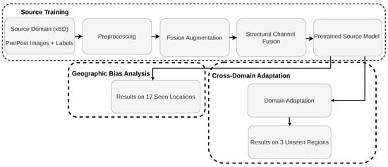
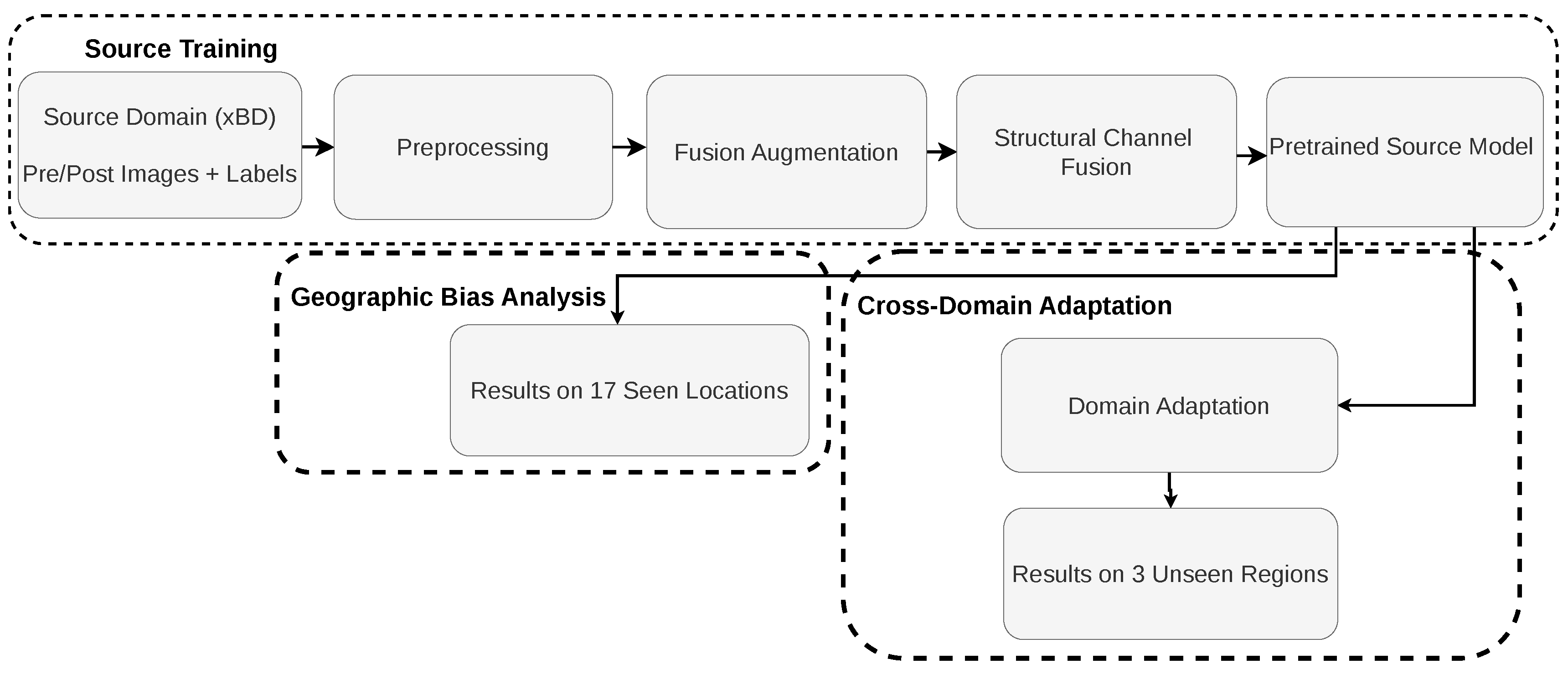
Figure 1 presents the overall pipeline of the proposed framework for building damage detection and geographic bias analysis. First, the source-domain pre- and post-disaster images are preprocessed. Next, Fusion Augmentation is applied to enrich the original input representation with auxiliary structural channels. The resulting enhanced representation is then used to train the source model. Finally, the framework supports two downstream analyses: in-domain geographic bias analysis across 17 locations and cross-domain adaptation to unseen target regions using supervised or unsupervised adaptation methods.
Figure 1.
End-to-end pipeline of the proposed framework for geographic bias analysis and cross-domain building damage assessment.
3.1. Dataset
For building damage assessment, the xBD (xView2 Building Damage) dataset [5] is the largest publicly available dataset from satellite imagery. The dataset consists of paired pre- and post-disaster images collected by Maxar/DigitalGlobe satellites (Maxar Technologies Inc., Westminster, CO, USA) at a spatial resolution of 0.3–0.8 m. The dataset covers approximately 45,362 square kilometers and includes more than 850,000 annotated building polygons, collected from 19 disaster events across five continents. A wide range of hazard types are included in the xBD dataset, such as severe wildfires (Santa Rosa, Woolsey, Pinery, SoCal, Portugal), major hurricanes (Michael, Harvey, Matthew, Florence), destructive tornadoes (Moore, Joplin), volcanic eruptions (Guatemala, Lower Puna), earthquakes (Nepal, Mexico), floods (Midwest), and the Palu tsunami. These events take place across diverse climate zones, including tropical, volcanic, arid, temperate, and mountainous regions, making xBD one of the most diverse datasets available. Each building instance is labeled with a polygon footprint, and a damage level is assigned according to the four-tier Joint Damage Scale, which includes four categories: No damage, minor damage, major damage, and destroyed. The dataset also offers global disaster maps of affected locations and illustrative pre- and post-disaster image pairs.
Table 1 outlines four damage classes presented in the xBD dataset, ranging from undamaged buildings to completely destroyed structures. These classes describe the level of damage to each building, ranging from no structural issues to full collapse or destruction. The xBD dataset has a severe damage-class distribution imbalance, a pattern commonly seen in damage-related datasets. Table 2 presents the frequency of each category across the 19 disaster events. Out of a total of 411,357 labeled buildings, 76% fall in the no damage class, whereas minor damage, major damage, and destroyed make up only 7–9% of the whole dataset. This skewed distribution underscores the class imbalance challenge when training models on the xBD dataset.
Table 1.
Damage scale descriptions. Adapted from the xBD dataset [5], used under the Creative Commons license stated by the dataset source and the table formatting was prepared by the authors.
Table 2.
Class distribution in xBD dataset.
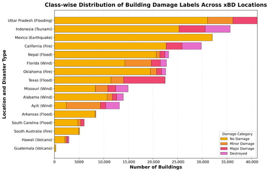
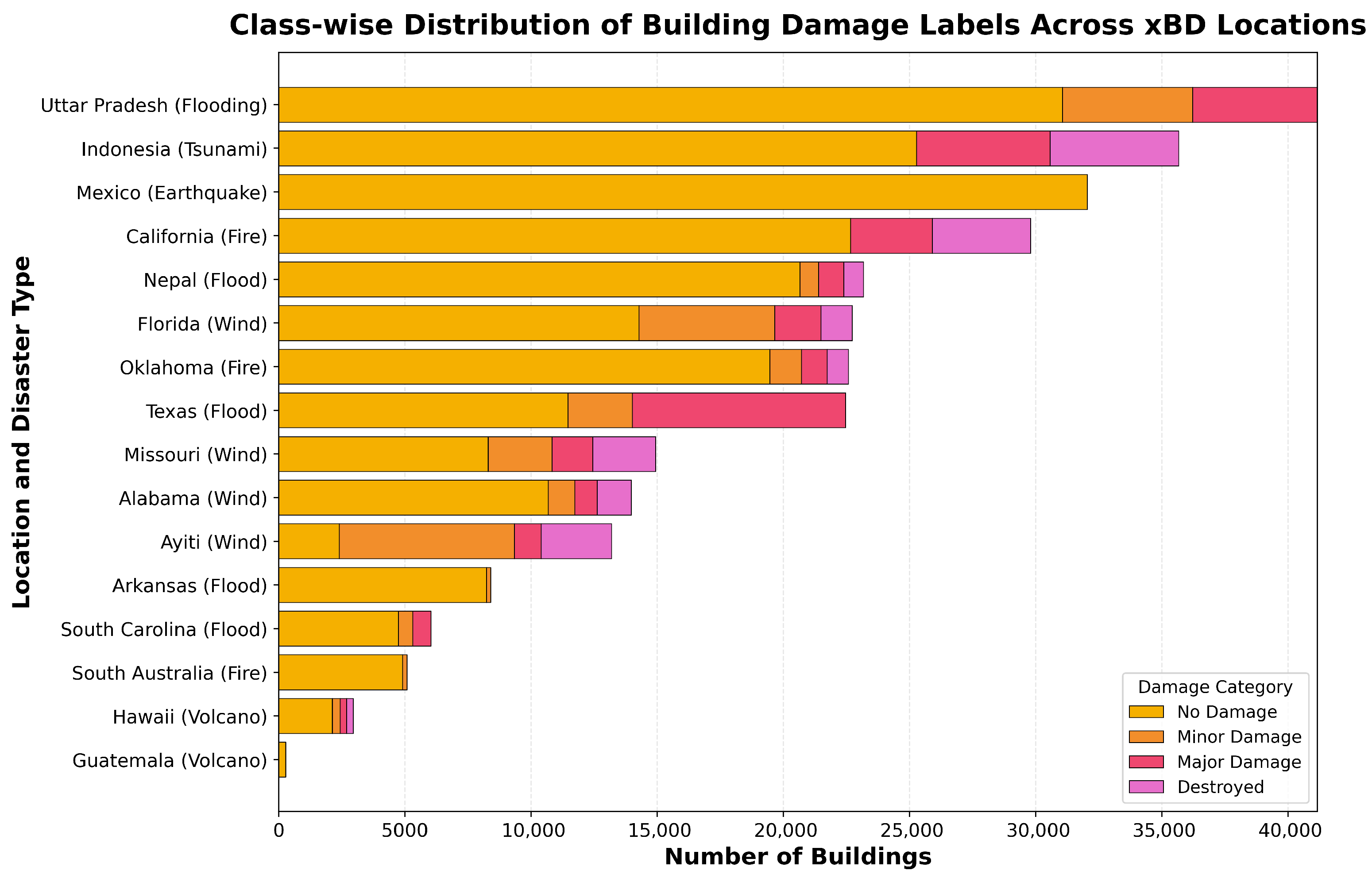
Furthermore, the distribution of samples varies significantly across disaster types and geographic regions, as illustrated in Figure 2. Some locations, such as Uttar Pradesh (flooding), Indonesia (tsunami), Mexico (earthquake), and California (fire), contribute a comparatively large number of labeled buildings, whereas others, including Hawaii (volcano), Guatemala (volcano), and South Australia (fire), are represented by substantially fewer samples. This geographic skew introduces an inherent bias, which is the central focus of our investigation.
Figure 2.
Class-wisedistribution of building damage labels across xBD locations used in this study. The figure highlights class imbalance and regional variation in sample composition [5].
3.2. Image Preprocessing
The xBD dataset includes building damage annotations in GeoJSON format, each containing polygon coordinates for a structure, along with metadata such as damage level, disaster type, and image identifiers. We converted these annotations to pixel-wise masks for model training using the following pipeline.
3.2.1. Polygon Extraction and Mask Generation
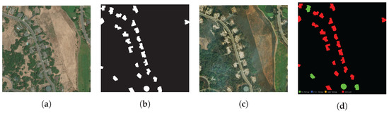
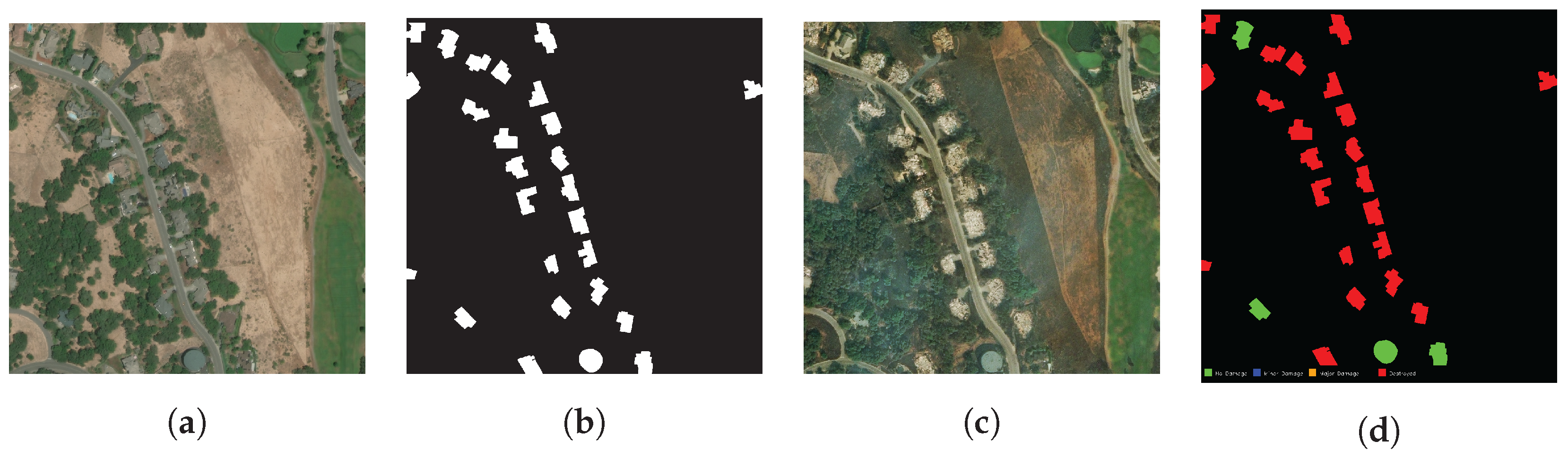
First, we parsed the GeoJSON files to extract the polygon coordinates (x,y), where each point represents a vertex of a building. We then converted these geographic coordinates into pixel coordinates using the geotransformation information of each image. Next, we generated masks for each building polygon using OpenCV’s fillPoly function. For building localization, pixels belonging to buildings were labeled as 1, and background pixels as 0. For damage classification, labels 0,1,2,3,4 represent background, no damage, minor, major, and destroyed, respectively. When multiple buildings overlapped at the same pixel, we assigned the label with the highest damage level. This ensured that regions with severe damage were properly captured. Figure 3 shows the full preprocessing pipeline from raw GeoJSON data to final masks.
Figure 3.
Pre-disaster and post-disaster images of the Santa Rosa wildfire with their corresponding masks. The pre- and post-disaster satellite images are from the publicly available xBD dataset [5] used under the Creative Commons Attribution-Non Commercial-ShareAlike 4.0 International license. The corresponding masks were generated by the authors. (a) Pre-disaster image. (b) Pre-disaster mask. (c) Post-disaster image. (d) Post-disaster mask.
3.2.2. Image Normalization
All satellite imagery is normalized using ImageNet statistics [38] to enable transfer learning from pretrained encoders.
where and represent the mean and standard deviation for the RGB channels. All images are downsized to 1024 × 1024 pixels, with zero-padding for smaller ones. To process images larger than , we adopt a sliding-window technique with 50% overlap and aggregate predictions via majority voting during inference.
3.3. Fusion Augmentation
Post-disaster satellite imagery presents significant challenges for AI-based damage detection: structural edges are obscured by debris, contrast is reduced by atmospheric or illumination effects, fine-grained damage features are masked by environmental factors, and buildings in vegetation-dense environments may be partially occluded, making structural boundaries difficult to isolate from RGB imagery alone. Conventional augmentation strategies—such as rotation, flipping, or color jittering—modify existing images but do not address these limitations; they may even degrade critical structural cues by reducing edge sharpness or amplifying noise [25].
To explicitly address these limitations, we employ a fusion-based input enhancement strategy that enriches standard RGB inputs with auxiliary structural channels, increasing the information available to the model without requiring additional training samples [25]. Unlike instance-based augmentation, which operates on image-level transformations, Fusion Augmentation encodes domain-relevant structural information directly into the input representation, preserving the features most critical for distinguishing damage levels across diverse environmental conditions. To achieve this, we use three auxiliary representations: Canny edge detection to emphasize building boundaries and structural discontinuities; contrast enhancement to improve local visibility of subtle damage patterns; and unsharp masking to sharpen fine structural details such as cracks, roof degradation, and boundary irregularities.
3.3.1. Canny Edge Detection
Structural edges are critical for AI-based damage detection, as damage manifests through geometric discontinuities. Edges play a crucial role in characterizing building layouts, especially in post-disaster images, where environmental factors may obscure these features [39]. In this study, we employ the Canny detector [40] due to its robustness and proven effectiveness in extracting well-defined structural boundaries. The algorithm consists of the following stages:
1. Noise reduction: A Gaussian filter is applied to suppress high-frequency noise while preserving key structural edges intact. The Gaussian kernel is defined as
where we use a Gaussian kernel with .
2. Gradient calculation: Image gradients and are computed using Sobel operators. The gradient magnitude and orientation are then derived as
3. Non-maximum suppression: To produce thin, well-localized edges, non-maximum suppression retains only pixels whose gradient magnitude is a local maximum along the gradient direction.
4. Double thresholding: Edge pixels are classified using high () and low () thresholds. We set and based on validation experiments.
5. Edge tracking by hysteresis: Weak edges that are connected to the strong edges are retained, whereas isolated weak edges are suppressed. These steps remove noise while guaranteeing edge continuity.
The resulting edge map highlights building boundaries, structural discontinuities, and damage-related features. Integrating these edge maps into the network enables an early emphasis on geometric cues essential for identifying building damage.
3.3.2. Contrast Enhancement
Contrast enhancement is applied to improve the visibility of subtle damage features by redistributing pixel intensities across the full dynamic range. In this study, we apply Contrast Limited Adaptive Histogram Equalization (CLAHE) [41], which performs contrast enhancement locally with small image tiles of pixels, while limiting the amplification of histogram bins through a clip limit of 2.0. This prevents the excessive noise enhancement that often occurs using global histogram equalization. CLAHE is applied independently to each RGB channel; the redistribution of histogram values is controlled by the following formulation:
where is the histogram count for bin . The resulting enhanced image reveals finer texture variations, weathering patterns, and subtle structural differences that help distinguish visually altered yet structurally intact surfaces, such as soot or ash deposits, from genuine damage.
3.3.3. Unsharp Masking
Unsharp masking [42] is applied to emphasize fine structural details by sharpening the image through the combination of the original and a blurred version. The sharpened output is computed as
where denotes the Gaussian-blurred image using a kernel with , and the sharpening strength is set to . This enhancement improves the visibility of subtle structural cues, such as small cracks and missing roof elements, while avoiding the artifacts that conventional sharpening filters may introduce.
3.3.4. Channel Fusion Strategy
After generating the auxiliary representations, including the edge map, contrast-enhanced image, and unsharp-masked image, each auxiliary output is converted into a single-channel grayscale representation and combined with the original RGB image. The fused input is constructed as
where denotes the three-channel RGB image, and E, C, and S denote the edge, contrast, and sharpness channels, respectively. This results in a six-channel input comprising three RGB channels and three auxiliary structural enhancement channels. The resulting representation preserves the visual content of the original image while providing additional information about boundaries, fine structural details, and local contrast that may not be clearly separable in RGB space alone. Using single-channel auxiliary features keeps the design compact while still capturing the structural cues relevant to damage assessment. Thus, the six-channel design balances richer input features with computational efficiency.
3.4. Domain Adaptation Techniques
Domain adaptation addresses the challenge of transferring knowledge learned from a source domain to a target domain with different underlying data distribution [43]. This capability is especially important in building damage assessment, where models trained on specific disasters and geographic regions must generalize to new and unseen scenarios. In this study, we investigate two complementary strategies: supervised fine-tuning, which depends on a small amount of labeled target data; and CORAL [44], an unsupervised feature alignment approach.
3.4.1. Supervised Fine-Tuning
Supervised fine-tuning adapts pretrained models to target domains using a limited number of labeled samples [45]. In this study, we use 30 labeled target-domain samples as a fixed, limited-label setting to examine whether a small amount of target supervision can improve transfer under geographic shift. In this approach, the early encode layers remain frozen to preserve low-level, transferable features such as edges and textures, while the deep encode layers and decoders are updated to learn domain-specific building characteristics and damage patterns. This selective updating allows the model to retain generalizable representations while effectively adapting to structural and environmental variations in the target domain. The fine-tuning process follows a standard training loop. Let be the pretrained model and the labeled target dataset. The early encoder layers are kept fixed, while the final encoder blocks and the decoder are unfrozen. For each training batch , predictions are computed, and the parameters of the unfrozen layers are updated to minimize the composite loss.
with weights , , and , following the top-performing xView2 formulation [44]. In the present study, this composite loss formulation was adopted from the xView2 implementation, and the loss weights were kept fixed rather than re-optimized for the six-channel input setting. The model was optimized using AdamW for 10 epochs with a learning rate of 0.001. Through this procedure, the model gradually aligns its higher-level representations with the target distribution while preserving useful pretrained structure.
3.4.2. Unsupervised CORAL Domain Adaptation
Unsupervised domain adaptation is performed using CORrelation ALignment (CORAL) [44], which aligns second-order statistics between the source and target domains by matching their feature covariance matrices. CORAL minimizes the distributional discrepancy through the covariance-matching objective
where and denote the covariance matrices of the source and target features, respectively, and is the Frobenius norm. The covariance matrices are computed as
where and are the source and target feature sets, respectively. To improve adaptation, CORAL loss is applied at multiple network layers, and the total multi-layer objective is
3.5. Benchmark Systems
In this paper, we used three xView2 competition winners as benchmark systems. The first-place xView2 solution [46] employs a combination of UNet-like architectures for building localization and Siamese neural networks for damage classification. Localization models are trained on pre-disaster images using several encoder backbones (e.g., ResNet34, SE-ResNeXt50, SENet154), which are then converted into Siamese networks for analyzing paired pre- and post-disaster inputs. The approach incorporates extensive data augmentation and a composite loss consisting of Dice, Focal, and cross-entropy terms.
The second-place solution [47] adopts UNet-like networks with pretrained DPN92 and DenseNet161 encoders for binary localization. Mixed-precision training (Apex) is used to improve computational efficiency, and localization and classification stages are optimized separately. Multiclass damage classification is performed using a Focal-with-Dice loss.
The third-place system [48] ensembles multiple semantic segmentation models trained with weighted cross-entropy to mitigate class imbalance. A shared encoder processes pre- and post-disaster imagery, whose extracted features are concatenated before entering the decoder. The ensemble spans several encoder families, including ResNets, DenseNets, and EfficientNets paired with UNet or FPN decoders, and integrates pseudo-labeling and weighted model averaging to enhance robustness. All three benchmark systems report F1 scores above 0.85 on the official xView2 test set, reflecting the effectiveness of ensemble modeling and advanced training strategies. However, as demonstrated in our experiments, these approaches degrade substantially when evaluated on geographically out-of-distribution regions, motivating the development of our Fusion Augmentation and domain adaptation methods.
3.6. Evaluation Metrics
Model performance is assessed using metrics that capture both localization accuracy and damage classification quality, consistent with the official xView2 evaluation protocol.
F1 score. The primary metric is the F1 score [49], defined as the harmonic mean of precision and recall:
where
We compute F1 scores separately for localization and for each damage category (no damage, minor, major, and destroyed). Following the xView2 protocol, overall damage-classification performance is reported as the harmonic mean of the class-wise F1 scores:
where ensuring that all categories contribute equally despite the dataset imbalance.
4. Results and Discussion
This section presents the experimental results and discusses the findings in the context of the existing literature.
4.1. Baseline Performance
The top three winning solutions from the xView2 challenge [46,47,48] represent the current state of the art in automated building damage assessment from satellite imagery. Table 3 presents the performance of these models on the official competition test set, demonstrating overall capabilities with localization F1 scores exceeding 0.84 and particularly high accuracy on the “no damage” class (F1 > 0.90). However, these models exhibit substantial performance degradation across two damage categories: minor and major. This pattern aligns with findings from the original xBD dataset paper [5].
Table 3.
Performance of top three winning solutions on the xView2 Challenge test set adapted from the reported first-, second-, and third-place xView2 winning solutions [46,47,48].
4.2. Geographic Bias
To investigate geographic biases, we constructed 17 location-specific test sets by withholding 10% of images from each disaster location in the xBD dataset. This approach allows a systematic evaluation of model generalization across diverse geographic contexts, disaster types, and environmental conditions. Table 4, Table 5 and Table 6 present comprehensive performance results for the top three winning solutions across all 17 xBD disaster locations and reveal substantial variation across regions and damage categories. A clear pattern emerges in several temperate U.S. regions, including Arkansas, Alabama, Florida, Missouri, Oklahoma, South Carolina, and Texas, where the models achieve localization F1 values above 0.87 and perform well across all damage categories. Several factors contributed to this achievement. Most of the training data in the xBD dataset comes from these locations, accounting for about 60% [5]. Second, they have relatively similar terrain, vegetation density, consistent building materials (mostly wood-frame construction with asphalt roofing), and architectural layouts, creating a homogeneous feature space that models can reliably learn. Third, the dominant disaster types in these regions, such as hurricanes, floods, and tornadoes, exhibit damage patterns well represented in the training corpus. This confirms Weber and Kané’s findings [50] that the similarity of training data greatly impacts model performance in remote sensing applications.
Table 4.
Location-wise performance of the top solution across 17 xBD disaster locations. Per-class F1 scores (localization, no damage, minor, major, destroyed) reveal significant geographic variability, forming the basis for subsequent geographic bias analysis [33,48] on each location from the xBD dataset.
Table 5.
Performance of second place solution [33,48] on each location from the xBD Dataset.
Table 6.
Performance of third place solution [33,48] on each location from the xBD dataset.
In contrast to temperate regions, Mediterranean and tropical regions (Hawaii, Portugal, South Australia, Indonesia, Ayiti) show modest performance degradation, with F1 scores typically 10–15% lower. The training distribution does not account for environmental variability in these places. For instance, Hawaii’s volcanic landscapes feature dense tropical vegetation and unique geological formations that obscure the boundaries of buildings. The Mediterranean climate of Portugal affects sunlight, vegetation (eucalyptus forests), and construction materials (stone and concrete) differently than North American training data. High humidity, dense vegetation, and informal settlement patterns, combined with non-Western architectural styles, characterize Indonesia’s tropical climate. Environmental variability leads to domain shift [51], where visual characteristics from temperate training data may not transfer well to climatically diverse test conditions. Vegetation and other non-building objects can introduce false alarms and reduce the accuracy of building detection in high-resolution satellite imagery [52].
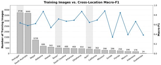
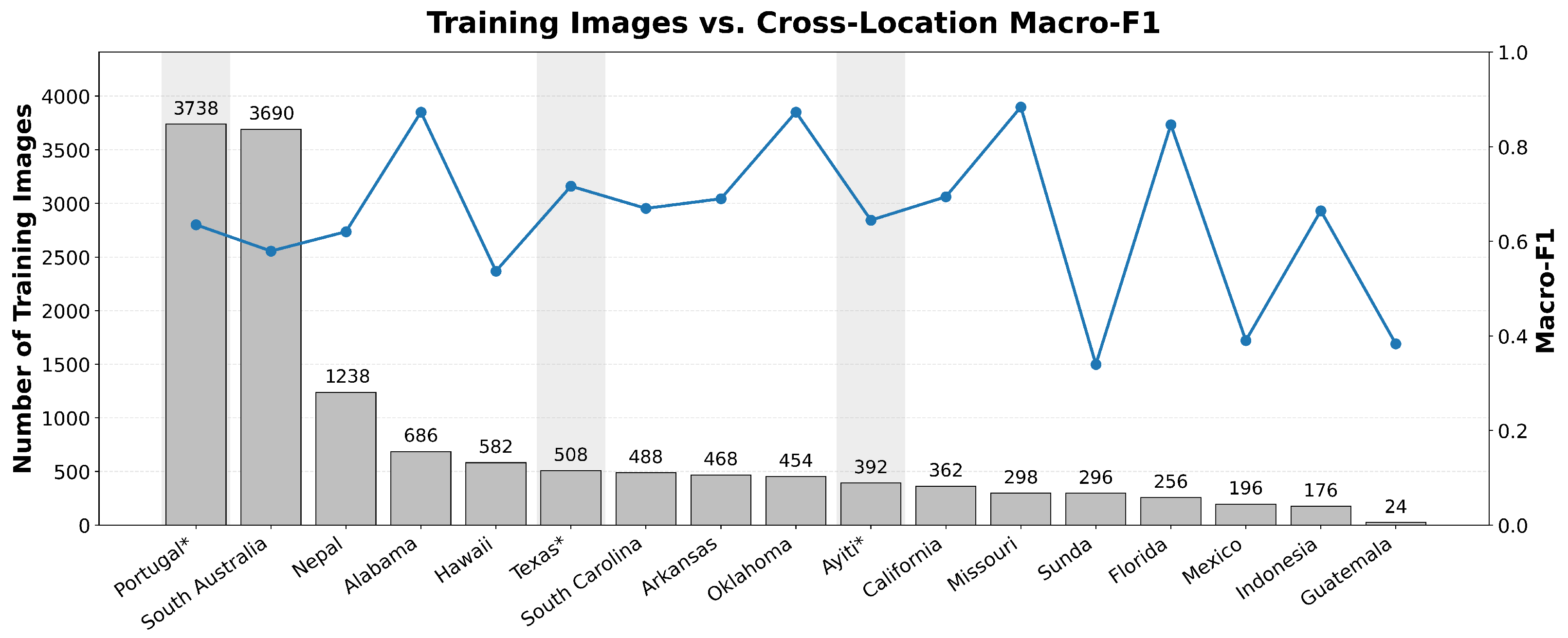
To better understand whether regional performance differences are primarily explained by training sample quantity, Figure 4 compares the number of training images per location with the corresponding macro-F1 score. No clear relationship emerges: Portugal and South Australia, despite having among the largest training sets in the benchmark, achieve macro-F1 scores substantially below locations such as Missouri and Oklahoma, which are trained on comparatively fewer samples. Conversely, several low-sample locations outperform high-sample counterparts on the same metric.
Figure 4.
Relationship between training sample count and macro-F1 across xBD locations. Bars show the number of training images, and the line shows the corresponding macro-F1 score. Locations marked with * denote out-of-domain test locations. The results show that having more training images does not necessarily correspond to better cross-location generalization.
The Nepal case illustrates this more clearly. Nepal does not have the largest training sample in the dataset. However, it still contains a substantial number of training images and exhibits weak performance for certain damage categories, particularly minor damage (F1 = 0.304) and Destroyed (F1 = 0.206), while major damage remains comparatively strong (F1 = 0.869). This class-dependent behavior suggests that transfer performance cannot be attributed solely to limited sample availability. Instead, it likely reflects a combination of geographic and structural mismatch, including terrain complexity, shadow effects, dense settlement patterns, and local architectural characteristics that differ from the dominant patterns in the training data.
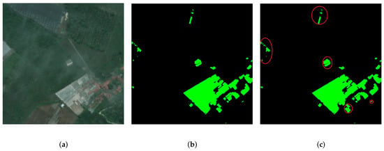
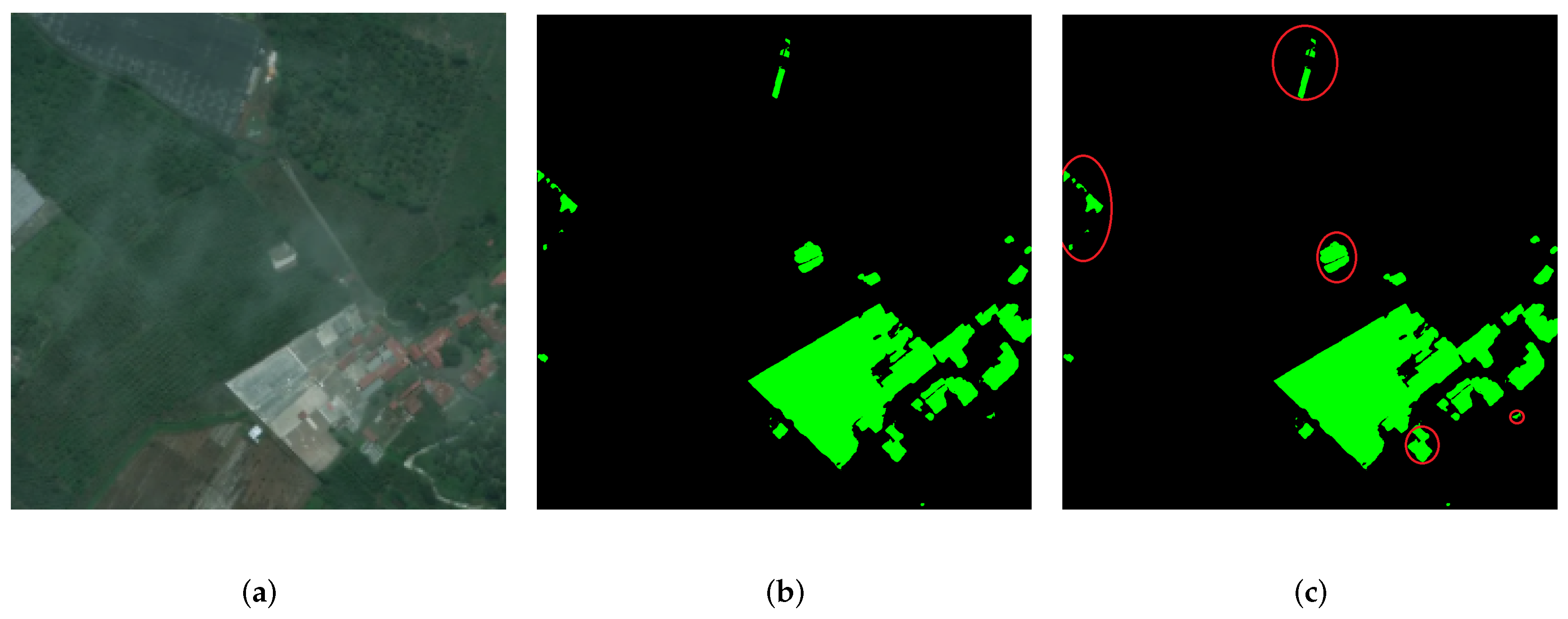
Similar behavior can be observed in other low-performing regions, as shown in Table 4, Table 5 and Table 6. For example, Mexico and Guatemala show near-zero or zero F1 scores for some damage categories, while Sunda also performs poorly across multiple classes. To provide qualitative insight into this behavior, Figure 5 shows a representative example from Guatemala comparing localization results before and after Fusion Augmentation. These cases likely reflect a combination of environmental variation, hazard-specific damage appearance, class imbalance, and reduced class separability due to domain shift, rather than a simple shortage of training examples. Overall, the results indicate that cross-location degradation in building damage assessment is shaped not only by how much data is available, but also by how well the source data captures the structural and environmental characteristics of the target region.
Figure 5.
Representative qualitative comparison from Guatemala. Panel (a) shows a post-disaster satellite image obtained from the publicly available xBD dataset [5], used under the Creative Commons license stated by the dataset source. Panels (b) and (c) show localization results before and after Fusion Augmentation, respectively, generated by the authors using the proposed method. Green regions in subfigures (b) and (c) indicate segmented building areas. Red circles were added by the authors to highlight representative regions where additional building structures are recovered after augmentation.
Geographic bias has major effects on practical disaster response. Despite strong aggregate performance metrics, state-of-the-art models may perform poorly in settings with environmental or structural differences from the training data. A model trained on North American disasters may have 90% accuracy in Florida but only 30% accuracy in Nepal, making it unreliable for worldwide humanitarian applications. The variety in dependability defies the universality assumption implicit in many catastrophe informatics systems and highlights the necessity for domain adaptation strategies that explicitly address geographic bias.
4.3. Domain Adaptation to Unseen Geographic Regions
To rigorously quantify geographic bias and evaluate mitigation strategies, we designed controlled out-of-domain experiments using three representative locations—Texas (temperate), Ayiti (tropical), and Portugal (Mediterranean)—that were completely excluded from model training. This experimental design simulates realistic deployment scenarios, where emergency responders must assess damage in regions for which pretrained models have no direct experience. In this setting, the domain adaptation analysis is used to examine how representative adaptation strategies affect cross-location performance under geographic shifts in the xBD benchmark. For each target location, we trained the first-place winning solution [46] from scratch on the remaining 16 xBD locations, creating truly out-of-domain test conditions. We then evaluated six configurations: (i) pretrained baseline model, (ii) pretrained model with Fusion Augmentation applied during training, (iii) pretrained model with supervised fine-tuning on 30 labeled target samples, (iv) pretrained model with both fine-tuning and Fusion Augmentation, (v) pretrained model with unsupervised CORAL domain adaptation [44], and (vi) pretrained model with CORAL and Fusion Augmentation. This comprehensive evaluation enables isolation of individual technique contributions and assessment of synergistic effects. The results, presented in Table 7, Table 8 and Table 9, reveal nuanced patterns of adaptation effectiveness across geographic contexts.
Table 7.
Domain adaptation results for Texas (temperate region). SDA: supervised domain adaptation, FA: Fusion Augmentation, and UDA: unsupervised domain adaptation. Bold values indicate the best performance for each metric.
Table 8.
Domain adaptation results for Ayiti (tropical region). SDA: supervised domain adaptation, FA: Fusion Augmentation, and UDA: unsupervised domain adaptation. Bold values indicate the best performance for each metric.
Table 9.
Domain adaptation results for Portugal (Mediterranean region). SDA: supervised domain adaptation, FA: Fusion Augmentation, and UDA: unsupervised domain adaptation. Bold values indicate the best performance for each metric.
Table 7 reveals moderate domain shift in climatically similar but geographically diverse locations. Under these conditions of moderate domain-shift due to geographic specificity, the pretrained baseline localization performance (F1 = 0.824) is acceptable, but intermediate damage categories (minor: 0.411, major: 0.553) show significant degradation (33% and 19%, respectively) compared to in-domain performance on similar climatic disasters. This degradation, despite Texas being a temperate flood scenario similar to training data from Arkansas and South Carolina, reveals that geographic specificity—urban development patterns, building codes, construction practices—introduces sufficient feature distribution shift to impair model performance. Fusion Augmentation alone shows slight improvements (minor: +5.8%, major: +3.5%), indicating that explicit structural feature enhancement can withstand domain transfer without target-specific adaptation.
Supervised fine-tuning has a significantly greater impact (minor: +15.0%, major: +9.2%), highlighting the significance of target-domain supervision. Combining fine-tuning with Fusion Augmentation yields the highest results (minor: 0.505, major: 0.632), with 23% and 14% improvements above baseline. For Texas, unsupervised CORAL domain adaptation [44] yields mixed results, improving minor damage (+10.9%) but reducing major damage performance (−19.6%). A possible explanation is negative transfer: although CORAL reduces the global feature distribution mismatch between the source and target domains, second-order alignment may also weaken class-discriminative boundaries when target-domain damage patterns are not well aligned with those of the source domain. In the Texas case, this may have reduced the separability of the major damage class, leading to degraded performance despite moderate gains in other categories. This suggests that supervised adaptation with limited labeled target data is more effective than unsupervised feature alignment under modest domain shift.
Table 8 shows more significant domain shift effects in tropical conditions. The pretrained baseline severely fails under domain shift in tropical conditions characterized by dense vegetation and environmental occlusion (localization: 0.685, minor: 0.311, major: 0.189), indicating that temperate disaster models are unsuitable for tropical environments. Tropical deployments demonstrate a significant geographic bias, with a 60% decrease in minor damage performance and a 76% decrease in major damage performance compared to temperate regions. Ji et al. [53] found that tropical vegetation presents unique challenges for building detection, including dense canopy cover, confusing shadows, and moisture-dependent reflectance changes, hindering damage assessment. Fusion Augmentation significantly improves performance (minor: +26.0%, major: +39.0%), indicating that edge detection and contrast enhancement partially compensate for environmental occlusion by highlighting structural boundaries despite vegetation covering RGB features. Combined fine-tuning with Fusion Augmentation yields the best tropical performance (localization: 0.841, minor: 0.496, major: 0.342), with 59% and 81% gains over the baseline. In significant-domain-shift scenarios, unsupervised CORAL adaptation shows noteworthy outcomes (minor: +30.4%, major: +33.8%), indicating that statistical feature distribution alignment can be beneficial even without target labels. CORAL + Fusion Augmentation enhances unsupervised adaptation (minor: +35.5%, major: +61.7%), comparable to supervised fine-tuning without labeled target data. This has crucial implications for rapid natural-disaster response, where labeled data may not be available during the initial evaluation.
Table 9 shows that Portugal presents a distinct domain shift scenario combining Mediterranean climate characteristics with wildfire-specific damage patterns. Even though Portugal’s Mediterranean environment is closer to tropical training regions, intermediate damage detection dropped to tropical Ayiti levels (localization: 0.705, minor: 0.305, major: 0.199). A number of factors cause this poor generalization. Portugal’s eucalyptus forests have dense, uniform vegetation canopies with spectral signatures distinct from those of temperate deciduous forests and tropical rainforests in the training data. Ash covering from the 2017 Portuguese wildfires can mask building boundaries and create false damage signatures, as ash-covered roofs may resemble collapsed structures [54]. Additionally, Portuguese construction predominantly features stone and concrete, with terracotta roofing, and architectural characteristics that diverge from wood-frame North American structures, creating fundamental feature mismatches. Fusion Augmentation yields slightly smaller increases (minor: +6.8%, major: +6.3%) than Ayiti, possibly due to ash coverage affecting edge-recognition techniques. Supervised fine-tuning yields significant improvements (minor: +33.9%, major: +52.9%), whereas the combined technique achieves the best performance (minor: 0.427, major: 0.369), representing 40% and 85% over the baseline, respectively. CORAL + Fusion Augmentation enhances unsupervised performance (minor: +24.5%, major: +75.4%), with CORAL adaptation showing significant benefits (minor: +14.2%, major: +24.4%).
A number of patterns show up across all three out-of-domain locations, indicating geographic bias and adaptation techniques. As shown in Table 10, the proposed method achieves consistent improvements across all three locations. First, baseline performance degradation is proportional to environmental dissimilarity rather than geographic distance. Ayiti and Portugal experience severe degradation despite being geographically and climatically distinct, whereas Texas experiences moderate degradation despite being far from training regions. This shows that domain shift in disaster damage assessment is environmental and structural rather than geographical. Fusion Augmentation has constant gains (5–40% depending on shift severity) across every location, demonstrating the fundamental robustness of specific structural feature encoding to environmental variations. Next, fine-tuning and Fusion Augmentation work together to provide complementary advantages, resulting in 23–85% enhancements based on damage category and location. Fusion Augmentation yields superior structural representations that fine-tuning can more effectively adjust to target-domain characteristics, possibly due to complementary mechanisms. Finally, unsupervised CORAL adaptation shows variable effectiveness, with limited benefit for moderate domain shifts (Texas) but substantial gains for extreme shifts (Ayiti, Portugal), suggesting that statistical feature alignment becomes more valuable as shift severity increases and label distributions diverge.
Table 10.
Performance improvement for each damage class across out-of-domain locations using the top solution. We report the pretrained baseline, the proposed method (pretrained model + supervised domain adaptation + fusion augmentation), absolute improvement (), and relative improvement ().
This study has several limitations that should be considered when interpreting the findings. First, and most significantly, all domain adaptation experiments are conducted within the xBD benchmark; the absence of external validation on an independent post-disaster dataset limits the generalizability of the reported improvements beyond this benchmark. Second, the unsupervised adaptation setting evaluates CORAL with a fixed low-resource budget of 30 labeled samples, without systematic comparison against more recent domain adaptation methods, such as DANN [51], or adversarial feature alignment approaches. Third, loss-weight configurations (, , ) were adopted from the baseline xView2 formulation without re-optimization for the six-channel input setting; a dedicated sensitivity analysis of alternative weighting schemes remains an important direction for future work.
5. Conclusions
In this study, we investigate generalization challenges and geographic biases in AI-based building damage assessment from satellite imagery. Through extensive evaluation of the top-performing xView2 solutions across 17 disaster locations, we found that geographic and structural characteristics, as well as insufficient training data, degrade model performance. Our results demonstrate that structural feature enhancement through auxiliary channels is not merely beneficial but essential for robust AI-based damage detection across geographically diverse disaster scenarios. The Nepal case, together with the broader location-wise analysis, shows that environmental context, architectural diversity, and terrain complexity impact generalization behavior, and that training sample quantity alone does not fully explain regional performance differences. The experimental results show a 7.1% increase in overall F1 score, with significant gains in intermediate damage categories like minor and major damage. Domain adaptation experiments on three unseen locations demonstrate that Fusion Augmentation with supervised fine-tuning improves the minor and major classes by 40.8% and 60.0%, respectively, while unsupervised CORAL improves the minor and major damage classes by 24.2% and 39.5% over the benchmarks.
Future research could explore several directions to further improve cross-domain generalization in building damage assessment. First, incorporating foundation models, such as large-scale vision transformers pretrained on diverse remote sensing datasets, could help learn more transferable features and reduce the need for domain-specific fine-tuning. In addition, generative approaches like GAN-based domain adaptation (e.g., CycleGAN) could be used to synthesize realistic target-domain images from source data, improving performance under strong domain shifts. Finally, exploring more diverse data augmentation strategies and domain adaptation techniques on larger and more varied datasets could further enhance model robustness and generalization.
Author Contributions
Conceptualization, S.K., R.B. and A.D.; data curation, B.C. and U.T.; formal analysis, B.C. and U.T.; funding acquisition, S.K., R.B. and A.D.; investigation, B.C.; methodology, S.K., R.B. and A.D.; project administration, S.K., R.B. and A.D.; resources, S.K., R.B. and A.D.; software, B.C. and U.T.; supervision, S.K., R.B. and A.D.; validation, B.C. and U.T.; visualization, B.C. and U.T.; writing—original draft, B.C. and U.T.; writing—review and editing, S.K., U.T. and R.B. All authors have read and agreed to the published version of the manuscript.
Funding
This research was supported by the Kansas NSF EPSCoR grant (R55156).
Data Availability Statement
The xBD dataset used in this study is publicly available for download through the xView2 Challenge website: https://xview2.org/ (accessed on 1 January 2023). Further dataset details are available via the DOI record: https://doi.org/10.1184/R1/8135576.v1.
Conflicts of Interest
The authors declare no conflicts of interest.
References
- NASA. What Are the Effects of Climate Change on Extreme Weather? 2024. Available online: https://science.nasa.gov/climate-change/extreme-weather/ (accessed on 26 November 2024).
- United Nations Office for Disaster Risk Reduction (UNDRR). Hazard Definition and Classification Review: Technical Report. 2024. Available online: https://www.undrr.org/publication/hazard-definition-and-classification-review-technical-report (accessed on 26 November 2024).
- Defense Innovation Unit (DIU). Assessing Building Damage from Satellite Imagery. 2024. Available online: https://www.diu.mil/ai-xview-challenge (accessed on 26 November 2024).
- xView2 Challenge Team. Computer Vision for Building Damage Assessment. 2024. Available online: https://xview2.org/ (accessed on 26 November 2024).
- Gupta, R.; Goodman, B.; Patel, N.; Hosfelt, R.; Sajeev, S.; Heim, E.; Doshi, J.; Lucas, K.; Choset, H.; Gaston, M. Creating xBD: A dataset for assessing building damage from satellite imagery. In Proceedings of the IEEE/CVF Conference on Computer Vision and Pattern Recognition Workshops, Long Beach, CA, USA, 16–17 June 2019. [Google Scholar]
- Melamed, Z.; Shahar, Y.; Waisglass, N.; Kliger, M.; Averbuch-Elor, H. Bias in Building Damage Detection from Satellite Imagery. arXiv 2021, arXiv:2104.06533. [Google Scholar]
- Wiguna, S.; Adriano, B.; Mas, E.; Koshimura, S. Evaluation of deep learning models for building damage mapping in emergency response settings. IEEE J. Sel. Top. Appl. Earth Obs. Remote Sens. 2024, 17, 5651–5667. [Google Scholar] [CrossRef] [Scilit]
- Ryan-Mosley, T. How AI Can Actually Be Helpful in Disaster Response. 2023. Available online: https://www.technologyreview.com/2023/02/20/1068824/ai-actually-helpful-disaster-response-turkey-syria-earthquake/ (accessed on 26 November 2024).
- Duarte, D.; Nex, F.; Kerle, N.; Vosselman, G. Satellite image classification of building damages using airborne and satellite image samples in a deep learning approach. ISPRS Ann. Photogramm. Remote Sens. Spat. Inf. Sci. 2018, 4, 89–96. [Google Scholar] [CrossRef] [Scilit]
- He, K.; Gkioxari, G.; Dollár, P.; Girshick, R. Mask R-CNN. In Proceedings of the IEEE International Conference on Computer Vision, Venice, Italy, 22–29 October 2017; pp. 2961–2969. [Google Scholar]
- Wu, C.; Zhang, F.; Xia, J.; Xu, Y.; Li, G.; Xie, J.; Du, Z.; Liu, R. Building damage detection using U-Net with attention mechanism from pre- and post-disaster remote sensing datasets. Remote Sens. 2021, 13, 905. [Google Scholar] [CrossRef] [Scilit]
- Dong, L.; Shan, J. A comprehensive review of earthquake-induced building damage detection with remote sensing techniques. ISPRS J. Photogramm. Remote Sens. 2013, 84, 85–99. [Google Scholar] [CrossRef] [Scilit]
- Kim, D.; Won, J.; Lee, E.; Park, K.R.; Kim, J.; Park, S.; Yang, H.; Cha, M. Disaster assessment using computer vision and satellite imagery: Applications in detecting water-related building damages. Front. Environ. Sci. 2022, 10, 969758. [Google Scholar] [CrossRef] [Scilit]
- Zheng, Z.; Zhong, Y.; Wang, J.; Ma, A.; Zhang, L. Building damage assessment for rapid disaster response with a deep object-based semantic change detection framework: From natural disasters to man-made disasters. Remote Sens. Environ. 2021, 265, 112636. [Google Scholar] [CrossRef] [Scilit]
- Kaur, N.; Lee, C.C.; Mostafavi, A.; Mahdavi-Amiri, A. Large-scale building damage assessment using a novel hierarchical transformer architecture on satellite images. Comput.-Aided Civ. Infrastruct. Eng. 2023, 38, 2072–2091. [Google Scholar] [CrossRef] [Scilit]
- Tsai, F.J.; Lin, S.Y. A class distance penalty deep learning method for post-disaster building damage assessment. KSCE J. Civ. Eng. 2024, 28, 2005–2019. [Google Scholar] [CrossRef] [Scilit]
- Jakubik, J.; Muszynski, M.; Vössing, M.; Kühl, N.; Brunschwiler, T. Toward foundation models for earth monitoring: Generalizable deep learning models for natural hazard segmentation. In Proceedings of the IGARSS 2023—2023 IEEE International Geoscience and Remote Sensing Symposium, Pasadena, CA, USA, 16–21 July 2023. [Google Scholar]
- Ahn, K.; Han, S.; Park, S.; Kim, J.; Park, S.; Cha, M. Generalizable disaster damage assessment via change detection with vision foundation model. In Proceedings of the AAAI Conference on Artificial Intelligence, Philadelphia, PA, USA, 25 February–4 March 2025. [Google Scholar]
- Zhao, F.; Zhang, C.; Zhang, R.; Wang, T. Visual prompt learning of foundation models for post-disaster damage evaluation. Remote Sens. 2025, 17, 1664. [Google Scholar] [CrossRef] [Scilit]
- Yu, B.; Sun, Y.; Hu, J.; Chen, F.; Wang, L. Post-disaster building damage assessment based on gated adaptive multi-scale spatial-frequency fusion network. Int. J. Appl. Earth Obs. Geoinf. 2025, 141, 104629. [Google Scholar] [CrossRef] [Scilit]
- Melamed, D.; Johnson, C.; Gerg, I.D.; Zhao, C.; Blue, R.; Hoogs, A.; Clipp, B.; Morrone, P. Uncovering bias in building damage assessment from satellite imagery. In Proceedings of the IGARSS 2024—2024 IEEE International Geoscience and Remote Sensing Symposium, Athens, Greece, 7–12 July 2024. [Google Scholar]
- Gevaert, C.M.; Buunk, T.; van den Homberg, M.J.C. Auditing geospatial datasets for biases: Using global building datasets for disaster risk management. IEEE J. Sel. Top. Appl. Earth Obs. Remote Sens. 2024, 17, 12579–12590. [Google Scholar] [CrossRef] [Scilit]
- Adedeji, O.; Owoade, P.; Ajayi, O. Image augmentation for satellite images. arXiv 2022, arXiv:2207.14580. [Google Scholar] [CrossRef] [Scilit]
- Hao, X.; Liu, L.; Yang, R. A review of data augmentation methods of remote sensing image target recognition. Remote Sens. 2023, 15, 827–867. [Google Scholar] [CrossRef] [Scilit]
- Ghaffar, M.A.A.; McKinstry, A.; Maul, T.; Vu, T.T. Data augmentation approaches for satellite image super-resolution. ISPRS Ann. Photogramm. Remote Sens. Spat. Inf. Sci. 2019, 4, 47–54. [Google Scholar] [CrossRef] [Scilit]
- Takahashi, R.; Matsubara, T.; Uehara, K. Data augmentation using random image cropping and patching for deep CNNs. IEEE Trans. Circuits Syst. Video Technol. 2019, 30, 2917–2931. [Google Scholar] [CrossRef] [Scilit]
- Buslaev, A.; Iglovikov, V.I.; Khvedchenya, E.; Parinov, A.; Druzhinin, M.; Kalinin, A.A. Albumentations: Fast and flexible image augmentations. Information 2020, 11, 125. [Google Scholar] [CrossRef] [Scilit]
- DeVries, T. Improved regularization of convolutional neural networks with Cutout. arXiv 2017, arXiv:1708.04552. [Google Scholar] [CrossRef] [Scilit]
- Kshirsagar, S.R.; Falk, T.H. Quality-aware bag of modulation spectrum features for robust speech emotion recognition. IEEE Trans. Affect. Comput. 2022, 4, 1892–1905. [Google Scholar] [CrossRef] [Scilit]
- Kshirsagar, S.; Falk, T.H. Cross-language speech emotion recognition using bag-of-word representations, domain adaptation, and data augmentation. Sensors 2022, 22, 6445. [Google Scholar] [CrossRef] [Scilit] [PubMed]
- Kshirsagar, S.; Pendyala, A.; Falk, T.H. Task-specific speech enhancement and data augmentation for improved multimodal emotion recognition under noisy conditions. Front. Comput. Sci. 2023, 5, 1039261. [Google Scholar] [CrossRef] [Scilit]
- Parupati, B.C.R.; Kshirsagar, S.; Bagai, R.; Dutta, A. Towards robust building damage detection: Leveraging augmentation and domain adaptation. In Proceedings of the 2025 IEEE Green Technologies Conference (GreenTech), Wichita, Kansas, 26–28 March 2025. [Google Scholar]
- Parupati, B.C.R. Enhancing Generalizability in Building Damage Detection: Domain Adaptation and Augmentation Approaches for Post-Disaster Assessment. Ph.D. Thesis, Wichita State University, Wichita, KS, USA, 2024. [Google Scholar]
- Xu, Q.; Shi, Y.; Yuan, X.; Zhu, X.X. Universal domain adaptation for remote sensing image scene classification. IEEE Trans. Geosci. Remote Sens. 2023, 61, 4700515. [Google Scholar] [CrossRef] [Scilit]
- Hu, Y.; Tang, H. On the generalization ability of a global model for rapid building mapping from heterogeneous satellite images of multiple natural disaster scenarios. Remote Sens. 2021, 13, 984–1008. [Google Scholar] [CrossRef] [Scilit]
- Kshirsagar, S.R. Affective Human-Machine Interfaces: Towards Multi-lingual, Environment-Robust Emotion Detection from Speech; Institut National de la Recherche Scientifique: Quebec, QC, Canada, 2022. [Google Scholar]
- Mouradi, A.; Kshirsagar, S. Robust Building Damage Detection in Cross-Disaster Settings Using Domain Adaptation. arXiv 2026, arXiv:2603.14694. [Google Scholar] [CrossRef] [Scilit]
- Deng, J.; Dong, W.; Socher, R.; Li, L.J.; Li, K.; Fei-Fei, L. Imagenet: A large-scale hierarchical image database. In Proceedings of the 2009 IEEE Conference on Computer Vision and Pattern Recognition; IEEE: New York, NY, USA, 2009; pp. 248–255. [Google Scholar]
- Yang, S.; Peng, B.; Sui, T.; Wu, M.; Huang, Q. Advancing Self-Supervised Learning for Building Change Detection and Damage Assessment: Unified Denoising Autoencoder and Contrastive Learning Framework. Remote Sens. 2025, 17, 2717. [Google Scholar] [CrossRef] [Scilit]
- Canny, J. A computational approach to edge detection. IEEE Trans. Pattern Anal. Mach. Intell. 1986, PAMI-8, 679–698. [Google Scholar] [CrossRef] [Scilit]
- Zuiderveld, K. Contrast limited adaptive histogram equalization. In Graphics Gems; Academic Press Professional, Inc.: San Diego, CA, USA, 1994; pp. 474–485. [Google Scholar]
- Polesel, A.; Ramponi, G.; Mathews, V.J. Image enhancement via adaptive unsharp masking. IEEE Trans. Image Process. 2000, 9, 505–510. [Google Scholar] [CrossRef] [Scilit] [PubMed]
- Wilson, G.; Cook, D.J. A survey of unsupervised deep domain adaptation. ACM Trans. Intell. Syst. Technol. (TIST) 2020, 11, 1–46. [Google Scholar] [CrossRef] [Scilit]
- Sun, B.; Saenko, K. Deep CORAL: Correlation alignment for deep domain adaptation. In Proceedings of the Computer Vision—ECCV 2016 Workshops, Amsterdam, The Netherlands, 8–10, 15–16 October 2016; pp. 443–450. [Google Scholar]
- Yosinski, J.; Clune, J.; Bengio, Y.; Lipson, H. How transferable are features in deep neural networks? In Proceedings of the Advances in Neural Information Processing Systems, Montreal, QC, Canada, 8–13 December 2014. [Google Scholar]
- Durnov, V. xView2 First Place Solution. 2019. Available online: https://github.com/vdurnov/xview2_1st_place_solution (accessed on 10 September 2024).
- Seferbekov, S. xView2 Second Place Solution. 2019. Available online: https://github.com/selimsef/xview2_solution (accessed on 10 September 2024).
- Khvedchenya, E. xView2 Third Place. 2020. Available online: https://github.com/DIUx-xView/xView2_third_place (accessed on 10 September 2024).
- Powers, D.M. Evaluation: From precision, recall and F-measure to ROC, informedness, markedness and correlation. arXiv 2020, arXiv:2010.16061. [Google Scholar] [CrossRef] [Scilit]
- Weber, E.; Kané, H. Building Disaster Damage Assessment in Satellite Imagery with Multi-Temporal Fusion. arXiv 2020, arXiv:2004.05525. [Google Scholar] [CrossRef] [Scilit]
- Ganin, Y.; Ustinova, E.; Ajakan, H.; Germain, P.; Larochelle, H.; Laviolette, F.; Marchand, M.; Lempitsky, V. Domain-Adversarial Training of Neural Networks. J. Mach. Learn. Res. 2016, 17, 1–35. [Google Scholar]
- You, Y.; Wang, S.; Ma, Y.; Chen, G.; Wang, B.; Shen, M.; Liu, W. Building Detection from VHR Remote Sensing Imagery Based on the Morphological Building Index. Remote Sens. 2018, 10, 1287. [Google Scholar] [CrossRef] [Scilit]
- Ji, S.; Wei, S.; Lu, M. Building Extraction in Tropical Regions from High-Resolution Satellite Imagery Using Multispectral and Shadow Information. Remote Sens. 2019, 11, 2005. [Google Scholar] [CrossRef] [Scilit]
- Silva, P.R.D.; Pereira, J.C.; Moreira, F.; Oliveira, T.M. Wildfire Damage Assessment in Portugal Using High-Resolution Satellite Imagery. Remote Sens. 2018, 10, 1792. [Google Scholar] [CrossRef] [Scilit]

Disclaimer/Publisher’s Note: The statements, opinions and data contained in all publications are solely those of the individual author(s) and contributor(s) and not of MDPI and/or the editor(s). MDPI and/or the editor(s) disclaim responsibility for any injury to people or property resulting from any ideas, methods, instructions or products referred to in the content. |
© 2026 by the authors. Licensee MDPI, Basel, Switzerland. This article is an open access article distributed under the terms and conditions of the Creative Commons Attribution (CC BY) license.