Skip to Content
You are currently on the new version of our website. Access the old version .

Remote Sensing, Volume 14, Issue 12

2022 June-2 - 229 articles

Cover Story: 
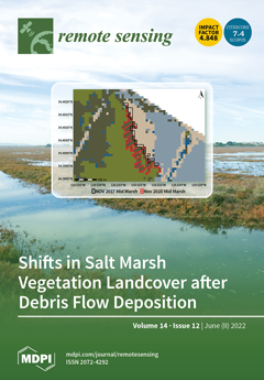
Carpinteria Salt Marsh Reserve, like many coastal salt marshes, is a dynamic and productive ecosystem that provides a wide variety of ecosystem services for coastal environments and communities. However, disturbances such as debris flows and sea level rise have the potential to degrade those services. In the absence of field data, we employed Sentinel-2 imagery and random forest classification to quantify landcover change associated with the Montecito Debris Flows of 2018. While total vegetated area remained constant after debris flow, the proportion of the high marsh vegetation community decreased, accompanied by a potential loss of species diversity. Such plant community shifts, identifiable through post-classification change detection, may negatively impact marsh function and resilience, especially in deposition-prone wetlands. View this paper
  • Issues are regarded as officially published after their release is announced to the table of contents alert mailing list .
  • You may sign up for email alerts to receive table of contents of newly released issues.
  • PDF is the official format for papers published in both, html and pdf forms. To view the papers in pdf format, click on the "PDF Full-text" link, and use the free Adobe Reader to open them.

Articles (229)

  • Article
  • Open Access
6 Citations
2,810 Views
14 Pages

20 June 2022

A long-strip differential interferometric synthetic aperture radar (DInSAR) measurement based on multi-frame image mosaicking is currently the realizable approach to measure large-scale ground deformation. As the spatial range of the mosaicked images...

  • Article
  • Open Access
8 Citations
3,260 Views
20 Pages

Classification of Electronic Devices Using a Frequency-Swept Harmonic Radar Approach

  • Handan Ilbegi,
  • Halil Ibrahim Turan,
  • Imam Samil Yetik and
  • Harun Taha Hayvaci

20 June 2022

A new method to classify electronic devices using a Frequency-Swept Harmonic Radar (FSHR) approach is proposed in this paper. The FSHR approach enables us to utilize the frequency diversity of the harmonic responses of the electronic circuits. Unlike...

  • Article
  • Open Access
3 Citations
4,141 Views
18 Pages

20 June 2022

Magnesian suite (Mg-suite) rocks represent plutonic materials from the lunar crust, and their global distribution can provide critical information for the early magmatic differentiation and crustal asymmetries of the Moon. Visible and near-infrared (...

  • Article
  • Open Access
29 Citations
5,779 Views
25 Pages

20 June 2022

The refractive index structure constant (Cn2) is a key parameter used in describing the influence of turbulence on laser transmissions in the atmosphere. Three different methods for estimating Cn2 were analyzed in detail. A new method that uses a com...

  • Article
  • Open Access
13 Citations
6,624 Views
21 Pages

Damage Properties of the Block-Stone Embankment in the Qinghai–Tibet Highway Using Ground-Penetrating Radar Imagery

  • Shunshun Qi,
  • Guoyu Li,
  • Dun Chen,
  • Mingtang Chai,
  • Yu Zhou,
  • Qingsong Du,
  • Yapeng Cao,
  • Liyun Tang and
  • Hailiang Jia

20 June 2022

The block-stone embankment is a special type of embankment widely used to protect the stability of the underlying warm and ice-rich permafrost. Under the influence of multiple factors, certain damages will still occur in the block-stone embankment af...

  • Article
  • Open Access
14 Citations
4,613 Views
22 Pages

A Dual-Generator Translation Network Fusing Texture and Structure Features for SAR and Optical Image Matching

  • Han Nie,
  • Zhitao Fu,
  • Bo-Hui Tang,
  • Ziqian Li,
  • Sijing Chen and
  • Leiguang Wang

20 June 2022

The matching problem for heterologous remote sensing images can be simplified to the matching problem for pseudo homologous remote sensing images via image translation to improve the matching performance. Among such applications, the translation of s...

  • Article
  • Open Access
6 Citations
3,247 Views
20 Pages

On-Orbit Calibration for Spaceborne Line Array Camera and LiDAR

  • Xiangpeng Xu,
  • Sheng Zhuge,
  • Banglei Guan,
  • Bin Lin,
  • Shuwei Gan,
  • Xia Yang and
  • Xiaohu Zhang

20 June 2022

For a multi-mode Earth observation satellite carrying a line array camera and a multi-beam line array LiDAR, the relative installation attitude of the two sensors is of great significance. In this paper, we propose an on-orbit calibration method for...

  • Article
  • Open Access
15 Citations
3,112 Views
15 Pages

20 June 2022

Although desertification has greatly increased across the Mongolian Plateau during the last decades of the 20th century, recent satellite records documented increasing vegetation growth since the 21st century in some areas of the Mongolian Plateau. C...

  • Article
  • Open Access
2,888 Views
18 Pages

20 June 2022

Dryland ecosystems are fragile to climate change due to harsh environmental conditions. Climate change affects vegetation growth primarily by altering some key bio-temperature thresholds. Key bio-temperatures are closely related to vegetation growth,...

  • Article
  • Open Access
12 Citations
5,123 Views
21 Pages

20 June 2022

Quadruped robots, an important class of unmanned aerial vehicles, have broad potential for applications in education, service, industry, military, and other fields. Their independent positioning plays a key role for completing assigned tasks in a com...

  • Technical Note
  • Open Access
8 Citations
5,366 Views
14 Pages

20 June 2022

Wildfire simulations depend on fuel representation. Present fuel models are mainly based on the density and properties of different vegetation types. This study aims to improve the accuracy of WRF-Fire wildfire simulations, by using synthetic-apertur...

  • Technical Note
  • Open Access
12 Citations
3,007 Views
14 Pages

Ant Colony Pheromone Mechanism-Based Passive Localization Using UAV Swarm

  • Yongkun Zhou,
  • Dan Song,
  • Bowen Ding,
  • Bin Rao,
  • Man Su and
  • Wei Wang

20 June 2022

The problem of passive localization using an unmanned aerial vehicle (UAV) swarm is studied. For multi-UAV localization systems with limited communication and observation range, the challenge is how to obtain accurate target state consistency estimat...

  • Article
  • Open Access
29 Citations
4,967 Views
29 Pages

Risk Assessment of Debris Flow in a Mountain-Basin Area, Western China

  • Yanyan Zhou,
  • Dongxia Yue,
  • Geng Liang,
  • Shuangying Li,
  • Yan Zhao,
  • Zengzu Chao and
  • Xingmin Meng

20 June 2022

Debris flow risk comprehensively reflects the natural and social properties of debris flow disasters and is composed of the risk of the disaster-causing body and the vulnerability of the carrier. The Bailong River Basin (BRB) is a typical mountainous...

  • Article
  • Open Access
5 Citations
2,708 Views
16 Pages

20 June 2022

Global Navigation Satellite System (GNSS) can provide high-precision three-dimensional real-time or quasi-real-time changes of monitoring points automatically in house monitoring applications. However, due to the signal sheltering problem, large obse...

  • Review
  • Open Access
18 Citations
7,008 Views
21 Pages

20 June 2022

Tidal wetlands, widely considered the most extensive reservoir of soil organic carbon (SOC), can benefit from remote sensing studies enabling spatiotemporal estimation and mapping of SOC stock. We found that a majority of the remote-sensing-based SOC...

  • Article
  • Open Access
36 Citations
7,479 Views
22 Pages

A Mask-Guided Transformer Network with Topic Token for Remote Sensing Image Captioning

  • Zihao Ren,
  • Shuiping Gou,
  • Zhang Guo,
  • Shasha Mao and
  • Ruimin Li

20 June 2022

Remote sensing image captioning aims to describe the content of images using natural language. In contrast with natural images, the scale, distribution, and number of objects generally vary in remote sensing images, making it hard to capture global s...

  • Article
  • Open Access
9 Citations
3,472 Views
18 Pages

20 June 2022

In this study, we investigate the characteristics of atmospheric parameters before, during, and after rain events in Bern, Switzerland. Ground-based microwave radiometer data of the TROpospheric WAter RAdiometer (TROWARA) with a time resolution of 7...

  • Article
  • Open Access
8 Citations
3,650 Views
11 Pages

A Martian Analogues Library (MAL) Applicable for Tianwen-1 MarSCoDe-LIBS Data Interpretation

  • Changqing Liu,
  • Zhongchen Wu,
  • Xiaohui Fu,
  • Ping Liu,
  • Yanqing Xin,
  • Ayang Xiao,
  • Hongchun Bai,
  • Shangke Tian,
  • Sheng Wan and
  • Zongcheng Ling
  • + 5 authors

20 June 2022

China’s first Mars exploration mission, named Tianwen-1, landed on Mars on 15 May 2021. The Mars Surface Composition Detector (MarSCoDe) payload onboard the Zhurong rover applied the laser-induced breakdown spectroscopy (LIBS) technique to acqu...

  • Article
  • Open Access
18 Citations
3,284 Views
30 Pages

19 June 2022

Reliable precipitation is crucial for hydrological studies over Tibetan Plateau (TP) basins with sparsely distributed rainfall gauges. In this study, four widely used precipitation products, including the Asian Precipitation Highly Resolved Observati...

  • Article
  • Open Access
4 Citations
4,295 Views
16 Pages

19 June 2022

In high-frequency surface wave radar (HFSWR) systems, clutter is a common phenomenon that causes objects to be submerged. Space-time adaptive processing (STAP), which uses two-dimensional data to increase the degrees of freedom, has recently become a...

  • Technical Note
  • Open Access
8 Citations
3,626 Views
13 Pages

Eye-Safe Aerosol and Cloud Lidar Based on Free-Space Intracavity Upconversion Detection

  • Wenjie Yue,
  • Tao Chen,
  • Wei Kong,
  • Xin Chen,
  • Genghua Huang and
  • Rong Shu

19 June 2022

We report an eye-safe aerosol and cloud lidar with an Erbium-doped fiber laser (EDFL) and a free-space intracavity upconversion detector as the transmitter and receiver, respectively. The EDFL was home-made, which could produce linearly-polarized pul...

  • Article
  • Open Access
14 Citations
3,827 Views
18 Pages

19 June 2022

Satellite-based PM2.5 estimation has been widely used to assess health impact associated with PM2.5 exposure and might be affected by spatial resolutions of satellite input data, e.g., aerosol optical depth (AOD). Here, based on Multi-Angle Implement...

  • Article
  • Open Access
15 Citations
3,697 Views
20 Pages

Variability in the Spatiotemporal Distribution Patterns of Greater Amberjack in Response to Environmental Factors in the Taiwan Strait Using Remote Sensing Data

  • Mubarak Mammel,
  • Muhamad Naimullah,
  • Ali Haghi Vayghan,
  • Jhen Hsu,
  • Ming-An Lee,
  • Jun-Hong Wu,
  • Yi-Chen Wang and
  • Kuo-Wei Lan

19 June 2022

The environmental characteristics of the Taiwan Strait (TS) have been linked to variations in the abundance and distribution of greater amberjack (Seriola dumerili) populations. Greater amberjack is a commercially and ecologically valuable species in...

  • Article
  • Open Access
20 Citations
4,439 Views
17 Pages

Wide and Deep Fourier Neural Network for Hyperspectral Remote Sensing Image Classification

  • Jiangbo Xi,
  • Okan K. Ersoy,
  • Ming Cong,
  • Chaoying Zhao,
  • Wei Qu and
  • Tianjun Wu

19 June 2022

Hyperspectral remote sensing image (HSI) classification is very useful in different applications, and recently, deep learning has been applied for HSI classification successfully. However, the number of training samples is usually limited, causing di...

  • Article
  • Open Access
25 Citations
4,121 Views
19 Pages

19 June 2022

Artificial islands and land reclamation are one of the most important ways to expand urban space in coastal cities. Long-term consolidation of reclaimed material and compaction of marine sediments can cause ground subsidence, which may threaten the b...

  • Article
  • Open Access
14 Citations
3,832 Views
23 Pages

19 June 2022

As two main drivers of vegetation dynamics, climate variability and human activities greatly influence net primary productivity (NPP) variability by altering the hydrothermal conditions and biogeochemical cycles. Therefore, studying NPP variability a...

  • Article
  • Open Access
8 Citations
4,112 Views
20 Pages

19 June 2022

The Ice, Cloud, and Land Elevation Satellite-2 (ICESat-2) with its land and vegetation height data product (ATL08), and Global Ecosystem Dynamics Investigation (GEDI) with its terrain elevation and height metrics data product (GEDI Level 2A) missions...

  • Article
  • Open Access
31 Citations
6,859 Views
24 Pages

UAV Remote Sensing for High-Throughput Phenotyping and for Yield Prediction of Miscanthus by Machine Learning Techniques

  • Giorgio Impollonia,
  • Michele Croci,
  • Andrea Ferrarini,
  • Jason Brook,
  • Enrico Martani,
  • Henri Blandinières,
  • Andrea Marcone,
  • Danny Awty-Carroll,
  • Chris Ashman and
  • Stefano Amaducci
  • + 5 authors

19 June 2022

Miscanthus holds a great potential in the frame of the bioeconomy, and yield prediction can help improve Miscanthus’ logistic supply chain. Breeding programs in several countries are attempting to produce high-yielding Miscanthus hybrids better...

  • Article
  • Open Access
10 Citations
4,420 Views
17 Pages

Smartphone-Based Unconstrained Step Detection Fusing a Variable Sliding Window and an Adaptive Threshold

  • Ying Xu,
  • Guofeng Li,
  • Zeyu Li,
  • Hao Yu,
  • Jianhui Cui,
  • Jin Wang and
  • Yu Chen

19 June 2022

Step detection for smartphones plays an important role in the pedestrian dead reckoning (PDR) for indoor positioning. Aiming at the problem of low step detection accuracy of smartphones in complex unconstrained states in PDR, smartphone-based unconst...

  • Article
  • Open Access
39 Citations
4,733 Views
19 Pages

Attention-Unet-Based Near-Real-Time Precipitation Estimation from Fengyun-4A Satellite Imageries

  • Yanbo Gao,
  • Jiping Guan,
  • Fuhan Zhang,
  • Xiaodong Wang and
  • Zhiyong Long

18 June 2022

Reliable near-real-time precipitation estimation is crucial for scientific research and resistance to natural disasters such as floods. Compared with ground-based precipitation measurements, satellite-based precipitation measurements have great advan...

  • Article
  • Open Access
13 Citations
3,636 Views
21 Pages

18 June 2022

Theoretically, the spectral efficiency of in-band full-duplex underwater acoustic communications (IBFD-UWAC) is twice that of a half-duplex one. However, the actual achievable spectral efficiency of IBFD-UWAC is determined by the performance of the s...

  • Technical Note
  • Open Access
13 Citations
2,527 Views
12 Pages

Impact of Lock-In Time Constant on Remote Monitoring of Trace Gas in the Atmospheric Column Using Laser Heterodyne Radiometer (LHR)

  • Fengjiao Shen,
  • Gaoxuan Wang,
  • Zhengyue Xue,
  • Tu Tan,
  • Zhensong Cao,
  • Xiaoming Gao and
  • Weidong Chen

18 June 2022

The time constant selected for lock-in amplification (LIA) has a crucial impact on observed line shapes in laser heterodyne spectroscopy, in particular in the case of ground-based remote monitoring of trace gas in the atmospheric column using laser h...

  • Article
  • Open Access
5 Citations
4,036 Views
15 Pages

A Newly Developed Algorithm for Cloud Shadow Detection—TIP Method

  • Viktoria Zekoll,
  • Raquel de los Reyes and
  • Rudolf Richter

18 June 2022

The masking of cloud shadows in optical satellite imagery is an important step in automated processing chains. A new method (the TIP method) for cloud shadow detection in multi-spectral satellite images is presented and compared to current methods. T...

  • Article
  • Open Access
7 Citations
3,154 Views
22 Pages

18 June 2022

In order to combine the spectral information of the multispectral (MS) image and the spatial information of the panchromatic (PAN) image, a pan-sharpening method based on β-divergence Non-negative Matrix Factorization (NMF) in the Non-Subsampled...

  • Article
  • Open Access
15 Citations
3,066 Views
19 Pages

18 June 2022

The lakes distributed in permafrost areas on the Tibetan Plateau (TP) have been experiencing significant changes during the past few decades as a result of the climate warming and regional wetting. In September 2011, an outburst occurred on an endorh...

  • Article
  • Open Access
14 Citations
5,092 Views
17 Pages

Can Mangrove Silviculture Be Carbon Neutral?

  • Giovanna Wolswijk,
  • Africa Barrios Trullols,
  • Jean Hugé,
  • Viviana Otero,
  • Behara Satyanarayana,
  • Richard Lucas and
  • Farid Dahdouh-Guebas

18 June 2022

Matang Mangrove Forest Reserve (MMFR) in peninsular Malaysia has been managed for pole and charcoal production from Rhizophora stands with a 30-year rotation cycle since 1902. The aim of this study is to estimate the carbon budget of the MMFR by cons...

  • Article
  • Open Access
19 Citations
3,369 Views
20 Pages

Characteristics of the Total Suspended Matter Concentration in the Hongze Lake during 1984–2019 Based on Landsat Data

  • Chenggong Du,
  • Yunmei Li,
  • Heng Lyu,
  • Kun Shi,
  • Naisen Liu,
  • Chen Yan,
  • Jinheng Pan,
  • Yulong Guo and
  • Yuan Li

18 June 2022

The Hongze Lake is the fourth largest freshwater lake in China and an important lake for the East Route of the South-to-North Water Diversion Project. The water quality of the lake affects social development and the lives of residents. To assess the...

  • Article
  • Open Access
10 Citations
3,772 Views
26 Pages

Drag and Attitude Control for the Next Generation Gravity Mission

  • Stefano Cesare,
  • Sabrina Dionisio,
  • Massimiliano Saponara,
  • David Bravo-Berguño,
  • Luca Massotti,
  • João Teixeira da Encarnação and
  • Bruno Christophe

18 June 2022

The Next Generation Gravity Mission (NGGM), currently in a feasibility study phase as a candidate Mission of Opportunity for ESA-NASA cooperation in the frame of the Mass Change and Geo-Sciences International Constellation (MAGIC), is designed to mon...

  • Review
  • Open Access
75 Citations
12,268 Views
22 Pages

Satellite Imagery to Map Topsoil Organic Carbon Content over Cultivated Areas: An Overview

  • Emmanuelle Vaudour,
  • Asa Gholizadeh,
  • Fabio Castaldi,
  • Mohammadmehdi Saberioon,
  • Luboš Borůvka,
  • Diego Urbina-Salazar,
  • Youssef Fouad,
  • Dominique Arrouays,
  • Anne C. Richer-de-Forges and
  • Bas Van Wesemael
  • + 2 authors

18 June 2022

There is a need to update soil maps and monitor soil organic carbon (SOC) in the upper horizons or plough layer for enabling decision support and land management, while complying with several policies, especially those favoring soil carbon storage. T...

  • Article
  • Open Access
27 Citations
3,793 Views
22 Pages

Drying–Wetting Changes of Surface Soil Moisture and the Influencing Factors in Permafrost Regions of the Qinghai-Tibet Plateau, China

  • Hongying Li,
  • Fenggui Liu,
  • Shengpeng Zhang,
  • Chaokun Zhang,
  • Cungui Zhang,
  • Weidong Ma and
  • Jing Luo

18 June 2022

Soil moisture (SM), an important variable in water conversion between the atmosphere and terrestrial ecosystems, plays a crucial role in ecological processes and the evolution of terrestrial ecosystems. Analyzing and exploring SM’s processes an...

  • Article
  • Open Access
6 Citations
2,262 Views
30 Pages

18 June 2022

Clustering-based methods of polarimetric synthetic aperture radar (PolSAR) image superpixel generation are popular due to their feasibility and parameter controllability. However, these methods pay more attention to improving boundary adherence and a...

  • Article
  • Open Access
5 Citations
3,163 Views
20 Pages

18 June 2022

The Northwest (NW) Atlantic has experienced extreme ecological impacts from Marine Heatwaves (MHWs) within the past decade. This paper focuses on four MHW active years (2012, 2016, 2017, and 2020) and the relationship between Sea Surface Temperature...

  • Article
  • Open Access
7 Citations
3,257 Views
22 Pages

Dynamic Antenna Selection for Colocated MIMO Radar

  • Gangsheng Zhang,
  • Junwei Xie,
  • Haowei Zhang,
  • Zhengjie Li and
  • Cheng Qi

18 June 2022

Antenna distribution plays an important role for the performance gain in multiple-input–multiple-output (MIMO) radar target tracking. Since to meet the requirements of the low probability of interception, especially in a hostile environment, on...

  • Article
  • Open Access
12 Citations
2,981 Views
15 Pages

17 June 2022

The coastline plays an important role in indicating the conditions of social-economic development in the coastal zone. In this study, an integrated assessment framework was proposed to address the provincial and county-level spatiotemporal dynamics o...

  • Article
  • Open Access
8 Citations
3,620 Views
18 Pages

Composite Electromagnetic Scattering and High-Resolution SAR Imaging of Multiple Targets above Rough Surface

  • Qingkuan Wang,
  • Chuangming Tong,
  • Ximin Li,
  • Yijin Wang,
  • Zhaolong Wang and
  • Tong Wang

17 June 2022

Aiming at the high efficiency of composite electromagnetic scattering analysis and radar target detection and recognition utilizing high-range resolution profile (HRRP) characteristics and high-resolution synthetic aperture radar (SAR) images, a near...

  • Article
  • Open Access
25 Citations
4,885 Views
28 Pages

17 June 2022

Vegetation phenology is an important indicator of vegetation dynamics. The boreal forest ecosystem is the main part of terrestrial ecosystem in the Northern Hemisphere and plays an important role in global carbon balance. In this study, the dynamic t...

  • Article
  • Open Access
4 Citations
2,846 Views
20 Pages

17 June 2022

In recent years, the Beijing–Tianjin–Hebei region has become one of the worst areas for haze pollution in China. Sun photometers are widely used for aerosol optical property monitoring due to the advantages of fully automatic acquisition,...

  • Article
  • Open Access
6 Citations
2,244 Views
24 Pages

Subpixel Snow Mapping Using Daily AVHRR/2 Data over Qinghai–Tibet Plateau

  • Ji Zhu,
  • Shuqin Cao,
  • Guofei Shang,
  • Jiancheng Shi,
  • Xinyun Wang,
  • Zhaojun Zheng,
  • Chenzou Liu,
  • Huicai Yang and
  • Baoni Xie

17 June 2022

Based on a linear spectral mixture model and multiple endmember spectral mixture analysis, using daily advanced very-high-resolution radiometer (AVHRR/2) data of the Qinghai–Tibet Plateau, a subpixel snow mapping algorithm was proposed in this...

  • Article
  • Open Access
5 Citations
2,802 Views
21 Pages

Diverse-Region Hyperspectral Image Classification via Superpixelwise Graph Convolution Technique

  • Yan Huang,
  • Xiao Zhou,
  • Bobo Xi,
  • Jiaojiao Li,
  • Jian Kang,
  • Shiyang Tang,
  • Zhanye Chen and
  • Wei Hong

17 June 2022

In this paper, a diverse-region hyperspectral image classification (DRHy) method is proposed by considering both irregularly local pixels and globally contextual connections between pixels. Specifically, the proposed method is operated on non-Euclide...

  • Article
  • Open Access
2 Citations
3,448 Views
17 Pages

17 June 2022

Monocular depth estimation is a fundamental yet challenging task in computer vision as depth information will be lost when 3D scenes are mapped to 2D images. Although deep learning-based methods have led to considerable improvements for this task in...

of 5

Get Alerted

Add your email address to receive forthcoming issues of this journal.

XFacebookLinkedIn
Remote Sens. - ISSN 2072-4292