Evaluation of Tidal Effect in Long-Strip DInSAR Measurements Based on GPS Network and Tidal Models

Abstract
1. Introduction
2. Materials and Methods
2.1. Traditional Tidal Models
2.2. Spatiotemporal Modelling of OTL Displacement Estimated from PPP Time Series
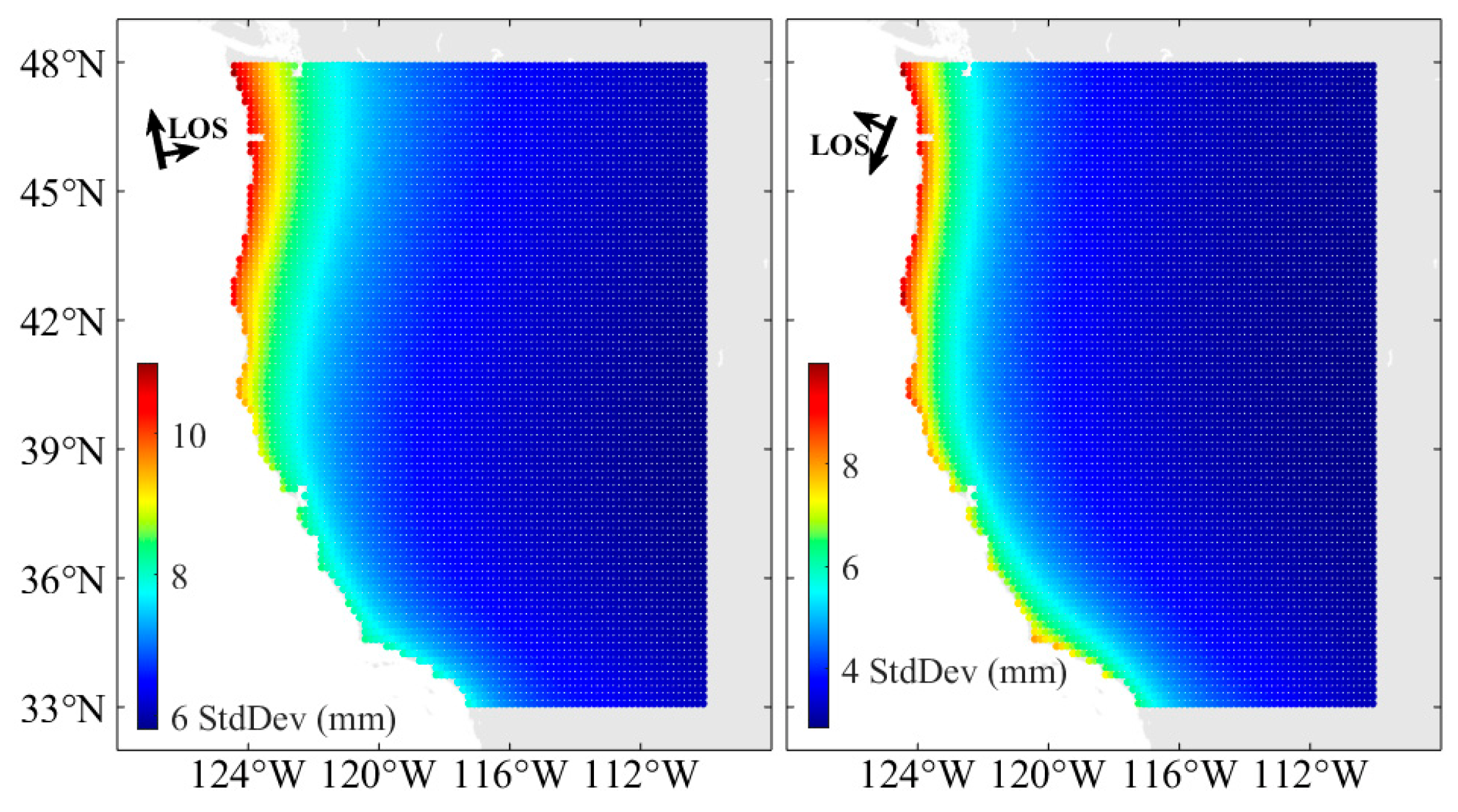
2.3. Tidal Displacements in the Long-Strip Differential Interferogram
2.4. Tidal Data Analysis and Processing
- (i).
- Image registration, interferogram generation, removal of the flat phase using SRTM with a 30 m resolution, phase unwrapping follows the minimum cost flow method, and geocoding is performed on the Sentinel-1 SLC image using GAMMA software [29]. The precise orbital file is added in the data processing, and the plane fitting is not implemented until the ground tidal displacement correction.
- (ii).
- The 29 differential interferograms are selected based on the principle of a small baseline [30].
- (iii).
- The differential interferograms of the nine adjacent frames are mosaicked to obtain the long-strip differential interferograms.
3. Results
3.1. The OTL Estimation Based on Kinematic PPP and Ocean Tide Models
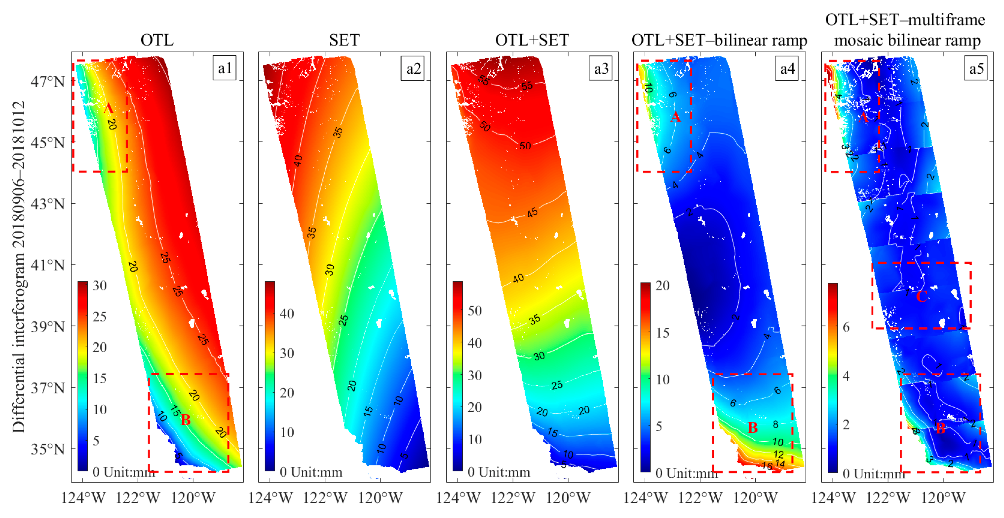
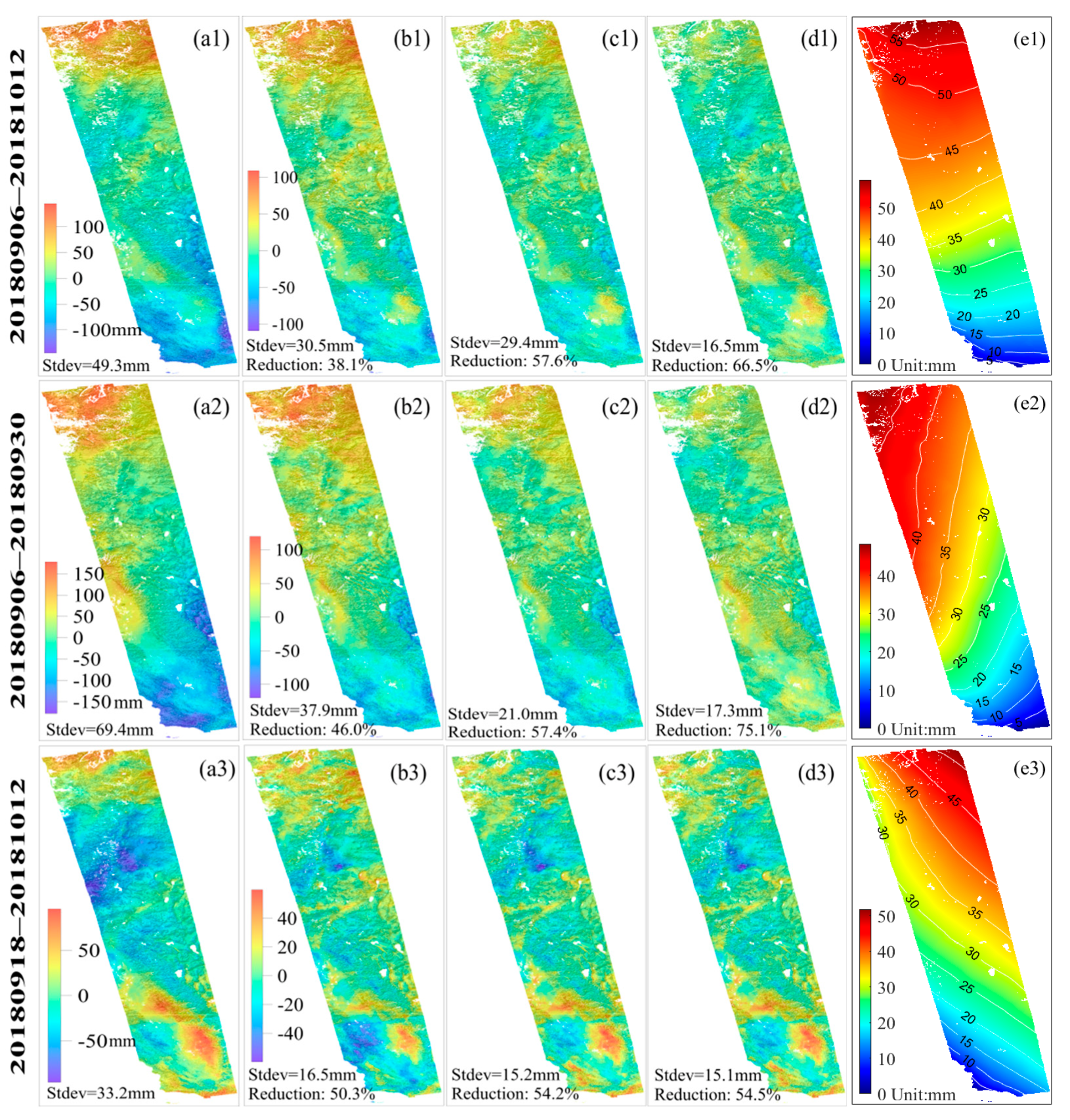
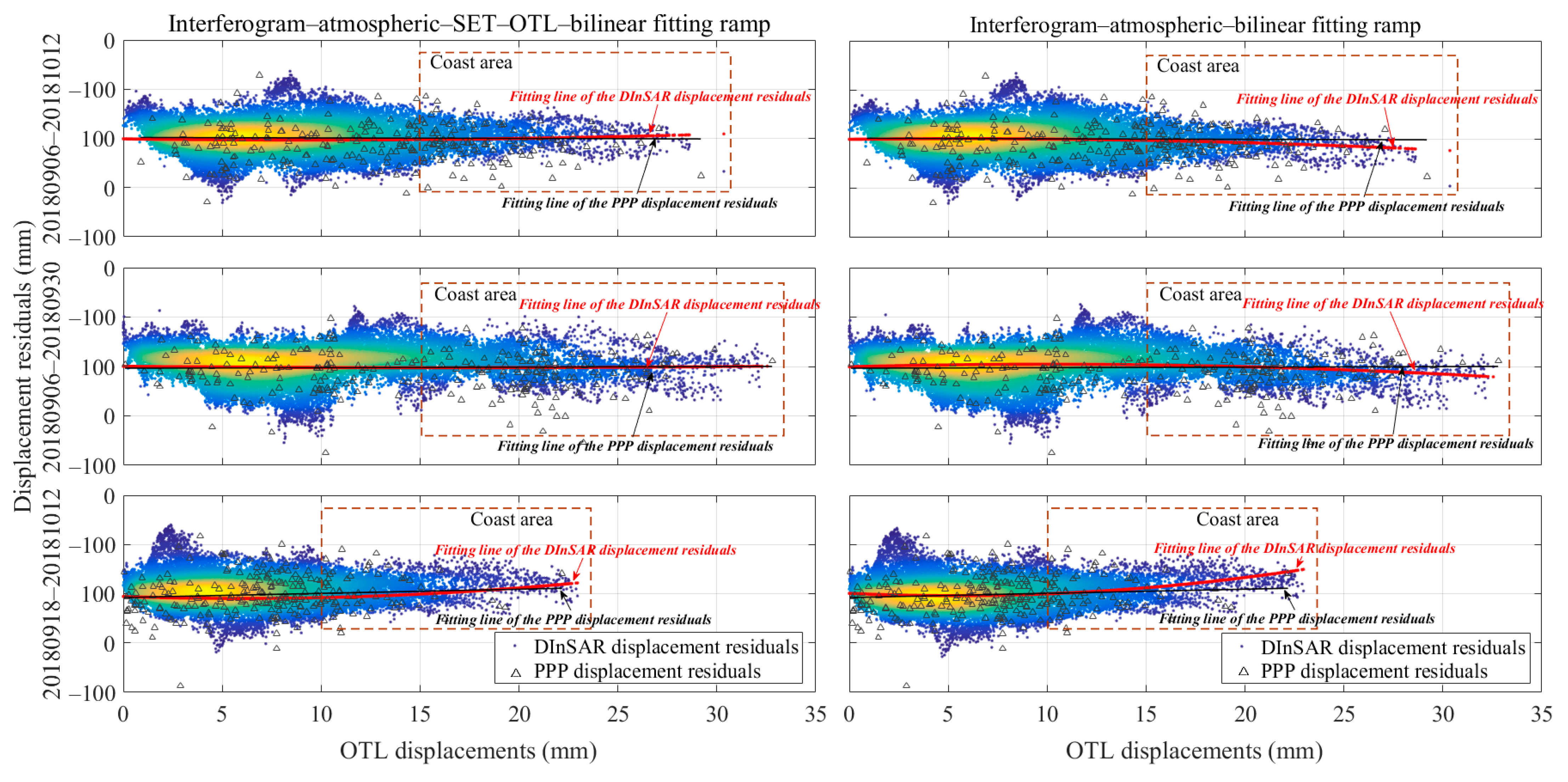
3.2. Assessment and Removal of Tide Displacements in a Long-Strip Differential Interferogram
4. Discussion
5. Conclusions
Author Contributions
Funding
Data Availability Statement
Acknowledgments
Conflicts of Interest
References
- Xu, X.; Sandwell, D.T. Toward Absolute Phase Change Recovery With InSAR: Correcting for Earth Tides and Phase Unwrapping Ambiguities. IEEE Trans. Geosci. Remote Sens. 2020, 58, 726–733. [Google Scholar] [CrossRef]
- Bähr, H.; Hanssen, R.F. Reliable estimation of orbit errors in spaceborne SAR interferometry. J. Geod. 2012, 86, 1147–1164. [Google Scholar] [CrossRef] [Scilit]
- Du, Y.; Fu, H.; Liu, L.; Feng, G.; Peng, X.; Wen, D. Orbit error removal in InSAR/MTInSAR with a patch-based polynomial model. Int. J. Appl. Earth Obs. 2021, 102, 102438. [Google Scholar] [CrossRef] [Scilit]
- Kowalczyk, K.; Pajak, K.; Wieczorek, B.; Naumowicz, B. An Analysis of Vertical Crustal Movements along the European Coast from Satellite Altimetry, Tide Gauge, GNSS and Radar Interferometry. Remote Sens. 2021, 13, 2173. [Google Scholar] [CrossRef] [Scilit]
- Francis, O.; Mazzega, P. Global charts of ocean tide loading effects. J. Geophys. Res. 1990, 95, 11411. [Google Scholar] [CrossRef] [Scilit]
- Melachroinos, S.A.; Biancale, R.; Llubes, M.; Perosanz, F.; Lyard, F.; Vergnolle, M.; Bouin, M.N.; Masson, F.; Nicolas, J.; Morel, L.; et al. Ocean tide loading (OTL) displacements from global and local grids: Comparisons to GPS estimates over the shelf of Brittany, France. J. Geod. 2008, 82, 357–371. [Google Scholar] [CrossRef] [Scilit]
- Wu, K.; Ji, C.; Luo, L.; Wang, X. Simulation Study of Moon-Based InSAR Observation for Solid Earth Tides. Remote Sens. 2020, 12, 123. [Google Scholar] [CrossRef] [Scilit]
- Jolivet, R.; Agram, P.S.; Lin, N.Y.; Simons, M.; Doin, M.P.; Peltzer, G.; Li, Z. Improving InSAR geodesy using Global Atmospheric Models. J. Geophys. Res. Solid Earth 2014, 119, 2324–2341. [Google Scholar] [CrossRef] [Scilit]
- DiCaprio, C.J.; Simons, M. Importance of ocean tidal load corrections for differential InSAR. Geophys. Res. Lett. 2008, 35, L22309. [Google Scholar] [CrossRef] [Scilit]
- Lyard, F.; Lefevre, F.; Letellier, T.; Francis, O. Modelling the global ocean tides: Modern insights from FES2004. Ocean Dyn. 2006, 56, 394–415. [Google Scholar] [CrossRef] [Scilit]
- Peng, W.; Wang, Q.; Cao, Y. Analysis of Ocean Tide Loading in Differential InSAR Measurements. Remote Sens. 2017, 9, 101. [Google Scholar] [CrossRef] [Scilit]
- Peng, W.; Wang, Q.; Zhan, F.B.; Cao, Y. Spatiotemporal Ocean Tidal Loading in InSAR Measurements Determined by Kinematic PPP Solutions of a Regional GPS Network. IEEE J. Sel. Top. Appl. Earth Obs. Remote Sens. 2020, 13, 3772–3779. [Google Scholar] [CrossRef] [Scilit]
- Yu, C.; Penna, N.T.; Li, Z. Ocean Tide Loading Effects on InSAR Observations Over Wide Regions. Geophys. Res. Lett. 2020, 47, e2020GL088184. [Google Scholar] [CrossRef] [Scilit]
- Wu, Z.; Jiang, M.; Xiao, R.; Xu, J. Ocean tide loading correction for InSAR measurements: Comparison of different ocean tide models. Geod. Geodyn. 2022, 13, 170–178. [Google Scholar] [CrossRef] [Scilit]
- Egbert, G.D.; Erofeeva, S.Y. Efficient Inverse Modeling of Barotropic Ocean Tides. J. Atmos. Ocean. Technol. 2002, 19, 183–204. [Google Scholar] [CrossRef] [Scilit]
- Shum, C.K.; Woodworth, P.L.; Andersen, O.B.; Egbert, G.D.; Francis, O.; King, C.; Klosko, S.M.; Le Provost, C.; Li, X.; Molines, J.-M.; et al. Accuracy assessment of recent ocean tidal models. J. Geophys. Res. 1997, 102, 125–173. [Google Scholar] [CrossRef] [Scilit]
- Thomas, I.D.; King, M.A.; Clarke, P.J. A comparison of GPS, VLBI and model estimates of ocean tide loading displacements. J. Geod. 2007, 81, 359–368. [Google Scholar] [CrossRef] [Scilit]
- Dehant, V.; Defraigne, P.; Wahr, J.M. Tides for a convective Earth. J. Geophys. Res. 1999, 104, 1035–1058. [Google Scholar] [CrossRef] [Scilit]
- Petit, G.; Luzum, B. IERS Conventions (2010), Technical Report DTIC Document; International Earth Rotation and Reference Systems Service: Frankfurt, Germany, 2010; No. 36; p. 180. [Google Scholar]
- Lu, F.; Konecny, M.; Chen, M.; Reznik, T. A Barotropic Tide Model for Global Ocean Based on Rotated Spherical Longitude-Latitude Grids. Water 2021, 13, 2670. [Google Scholar] [CrossRef] [Scilit]
- Bos, M.S.; Penna, N.T.; Baker, T.F.; Clarke, P.J. Ocean tide loading displacements in western Europe: 2. GPS-observed anelastic dispersion in the asthenosphere. J. Geophys. Res. Solid Earth 2015, 120, 6540–6557. [Google Scholar] [CrossRef] [Scilit]
- Abbaszadeh, M.; Clarke, P.J.; Penna, N.T. Benefits of combining GPS and GLONASS for measuring ocean tide loading displacement. J. Geod. 2020, 94, 63. [Google Scholar] [CrossRef] [Scilit]
- Yuan, L.; Chao, B.F. Analysis of tidal signals in surface displacement measured by a dense continuous GPS array. Earth Planet. Sci. Lett. 2012, 355–356, 255–261. [Google Scholar] [CrossRef] [Scilit]
- Wei, G.; Wang, Q.; Peng, W. Accurate Evaluation of Vertical Tidal Displacement Determined by GPS Kinematic Precise Point Positioning: A Case Study of Hong Kong. Sensors 2019, 19, 2559. [Google Scholar] [CrossRef] [Scilit] [PubMed]
- Agnew, D.C. NLOADF; a program for computing ocean-tide loading. J. Geophys. Res. Solid Earth 1997, 102, 5109–5110. [Google Scholar] [CrossRef] [Scilit]
- Suykens, J.A.K.; Vandewalle, J. Recurrent least squares support vector machines. IEEE Trans. Circuits Syst. I Fundam. Theory Appl. 2000, 47, 1109–1114. [Google Scholar] [CrossRef]
- Hooper, A.; Bekaert, D.; Spaans, K.; Arıkan, M. Recent advances in SAR interferometry time series analysis for measuring crustal deformation. Tectonophysics 2012, 514–517, 1–13. [Google Scholar] [CrossRef] [Scilit]
- Cao, Y.; Joónsson, S.; Li, Z. Advanced InSAR Tropospheric Corrections From Global Atmospheric Models that Incorporate Spatial Stochastic Properties of the Troposphere. J. Geophys. Res. Solid Earth 2021, 126, e2020JB020952. [Google Scholar] [CrossRef] [Scilit]
- Wegnüller, U.; Werner, C.; Strozzi, T.; Wiesmann, A.; Frey, O.; Santoro, M. Sentinel-1 Support in the GAMMA Software. Procedia Comput. Sci. 2016, 100, 1305–1312. [Google Scholar] [CrossRef] [Scilit]
- Berardino, P.; Fornaro, G.; Lanari, R.; Sansosti, E. A new algorithm for surface deformation monitoring based on small baseline differential SAR interferograms. IEEE Trans. Geosci. Remote Sens. 2002, 40, 2375–2383. [Google Scholar] [CrossRef] [Scilit]
- Bekaert, D.P.S.; Walters, R.J.; Wright, T.J.; Hooper, A.J.; Parker, D.J. Statistical comparison of InSAR tropospheric correction techniques. Remote Sens. Environ. 2015, 170, 40–47. [Google Scholar] [CrossRef] [Scilit]


Publisher’s Note: MDPI stays neutral with regard to jurisdictional claims in published maps and institutional affiliations. |
© 2022 by the authors. Licensee MDPI, Basel, Switzerland. This article is an open access article distributed under the terms and conditions of the Creative Commons Attribution (CC BY) license (https://creativecommons.org/licenses/by/4.0/).
Share and Cite
Peng, W.; Wang, Q.; Cao, Y.; Xing, X.; Hu, W. Evaluation of Tidal Effect in Long-Strip DInSAR Measurements Based on GPS Network and Tidal Models. Remote Sens. 2022, 14, 2954. https://doi.org/10.3390/rs14122954
Peng W, Wang Q, Cao Y, Xing X, Hu W. Evaluation of Tidal Effect in Long-Strip DInSAR Measurements Based on GPS Network and Tidal Models. Remote Sensing. 2022; 14(12):2954. https://doi.org/10.3390/rs14122954
Chicago/Turabian StylePeng, Wei, Qijie Wang, Yunmeng Cao, Xuemin Xing, and Wenjie Hu. 2022. "Evaluation of Tidal Effect in Long-Strip DInSAR Measurements Based on GPS Network and Tidal Models" Remote Sensing 14, no. 12: 2954. https://doi.org/10.3390/rs14122954
APA StylePeng, W., Wang, Q., Cao, Y., Xing, X., & Hu, W. (2022). Evaluation of Tidal Effect in Long-Strip DInSAR Measurements Based on GPS Network and Tidal Models. Remote Sensing, 14(12), 2954. https://doi.org/10.3390/rs14122954