You are currently viewing a new version of our website. To view the old version click .

Remote Sensing, Volume 11, Issue 14

July-2 2019 - 106 articles

  • Issues are regarded as officially published after their release is announced to the table of contents alert mailing list .
  • You may sign up for email alerts to receive table of contents of newly released issues.
  • PDF is the official format for papers published in both, html and pdf forms. To view the papers in pdf format, click on the "PDF Full-text" link, and use the free Adobe Reader to open them.
Cover Story: 
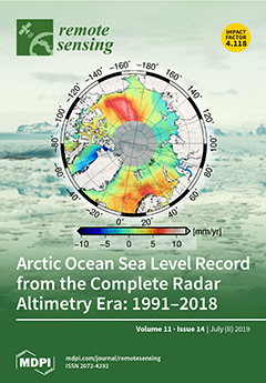
In recent years, there has been a large focus on the Arctic due to the rapid changes in the region. Arctic sea level determination is challenging due to the seasonal to permanent sea-ice cover, lack of regional coverage of satellites, satellite instruments’ ability to measure ice, insufficient geophysical models, residual orbit errors, and challenging retracking of satellite altimeter data. This study presents the ESA CCI DTU/TUM Sea Level Anomaly (SLA) record based on radar satellite altimetry data in the Arctic Ocean from ERS-1 (1991) to CryoSat-2 (2018). This is the longest time series available to date. The study focuses on the transition between conventional and synthetic aperture radar altimeter data to make a smooth time series regarding the measurement method. The SLA record was validated against tide gauges and shows good results. View this paper.

Articles (106)

  • Article
  • Open Access
16 Citations
6,180 Views
18 Pages

23 July 2019

Soil erosion affects food production, biodiversity, biogeochemical cycles, hydrology, and climate. Land-use changes accelerated by intensive human activities are a dominant anthropogenic factor inducing soil erosion globally. However, the impacts of...

  • Article
  • Open Access
10 Citations
6,775 Views
29 Pages

23 July 2019

Climate change and variability, soil types and soil characteristics, animal and microbial communities, and photosynthetic plants are the major components of the ecosystem that affect carbon sequestration potential of any location. This study used NAS...

  • Article
  • Open Access
34 Citations
6,916 Views
16 Pages

Advantages of Geostationary Satellites for Ionospheric Anomaly Studies: Ionospheric Plasma Depletion Following a Rocket Launch

  • Giorgio Savastano,
  • Attila Komjathy,
  • Esayas Shume,
  • Panagiotis Vergados,
  • Michela Ravanelli,
  • Olga Verkhoglyadova,
  • Xing Meng and
  • Mattia Crespi

23 July 2019

In this study, we analyzed signals transmitted by the U.S. Wide Area Augmentation System (WAAS) geostationary (GEO) satellites using the Variometric Approach for Real-Time Ionosphere Observation (VARION) algorithm in a simulated real-time scenario, t...

  • Article
  • Open Access
93 Citations
14,238 Views
19 Pages

Giving Ecological Meaning to Satellite-Derived Fire Severity Metrics across North American Forests

  • Sean A. Parks,
  • Lisa M. Holsinger,
  • Michael J. Koontz,
  • Luke Collins,
  • Ellen Whitman,
  • Marc-André Parisien,
  • Rachel A. Loehman,
  • Jennifer L. Barnes,
  • Jean-François Bourdon and
  • Jonathan Boucher
  • + 9 authors

23 July 2019

Satellite-derived spectral indices such as the relativized burn ratio (RBR) allow fire severity maps to be produced in a relatively straightforward manner across multiple fires and broad spatial extents. These indices often have strong relationships...

  • Article
  • Open Access
13 Citations
5,653 Views
18 Pages

Improvement of Remote Sensing-Based Assessment of Defoliation of Pinus spp. Caused by Thaumetopoea pityocampa Denis and Schiffermüller and Related Environmental Drivers in Southeastern Spain

  • Javier Pérez-Romero,
  • Rafael María Navarro-Cerrillo,
  • Guillermo Palacios-Rodriguez,
  • Cristina Acosta and
  • Francisco Javier Mesas-Carrascosa

23 July 2019

This study used Landsat temporal series to describe defoliation levels due to the Pine Processionary Moth (PPM) in Pinus forests of southeastern Andalusia (Spain), utilizing Google Earth Engine. A combination of remotely sensed data and field survey...

  • Article
  • Open Access
16 Citations
4,469 Views
19 Pages

22 July 2019

Identifying hydrothermal zoning pattern associated with porphyry copper deposit is important for indicating its economic potential. Traditional approaches like systematic sampling and conventional geological mapping are time-consuming and labor exten...

  • Article
  • Open Access
27 Citations
8,414 Views
29 Pages

22 July 2019

The Arctic-Boreal regions experience strong changes of air temperature and precipitation regimes, which affect the thermal state of the permafrost. This results in widespread permafrost-thaw disturbances, some unfolding slowly and over long periods,...

  • Article
  • Open Access
31 Citations
7,999 Views
20 Pages

Revealing Kunming’s (China) Historical Urban Planning Policies Through Local Climate Zones

  • Stéphanie Vandamme,
  • Matthias Demuzere,
  • Marie-Leen Verdonck,
  • Zhiming Zhang and
  • Frieke Van Coillie

22 July 2019

Over the last decade, Kunming has been subject to a strong urbanisation driven by rapid economic growth and socio-economic, topographical and proximity factors. As this urbanisation is expected to continue in the future, it is important to understand...

  • Article
  • Open Access
42 Citations
9,370 Views
29 Pages

21 July 2019

Many urban applications require building polygons as input. However, manual extraction from point cloud data is time- and labor-intensive. Hough transform is a well-known procedure to extract line features. Unfortunately, current Hough-based approach...

  • Article
  • Open Access
16 Citations
5,679 Views
19 Pages

Automatic Vector-Based Road Structure Mapping Using Multibeam LiDAR

  • Junqiao Zhao,
  • Xudong He,
  • Jun Li,
  • Tiantian Feng,
  • Chen Ye and
  • Lu Xiong

21 July 2019

The high-definition map (HD-map) of road structures is crucial for the safe planning and control of autonomous vehicles. However, generating and updating such maps requires intensive manual work. Simultaneous localization and mapping (SLAM) is able t...

of 11