Impacts of Land-Use Changes on Soil Erosion in Water–Wind Crisscross Erosion Region of China


Abstract
1. Introduction
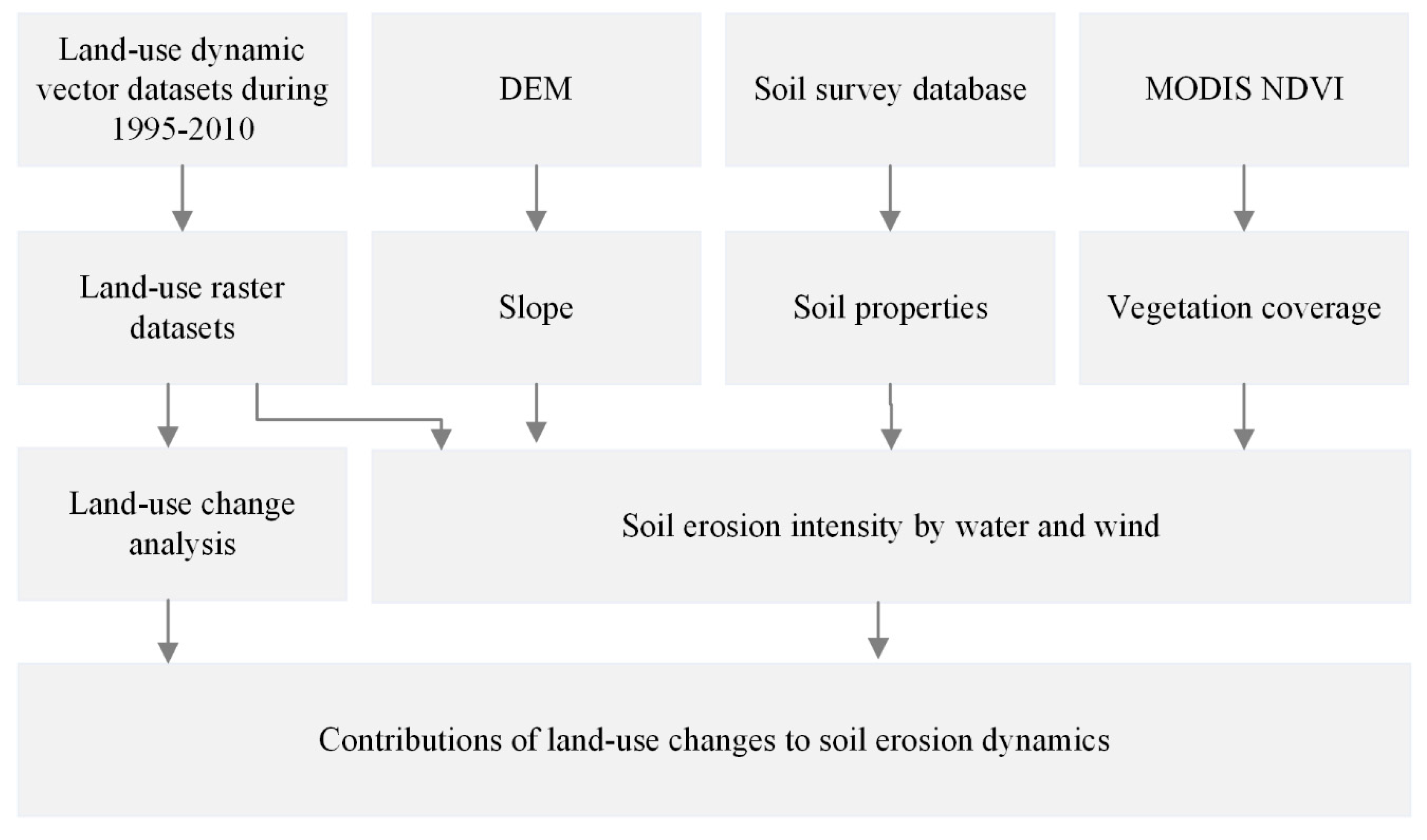
2. Materials and Methods
2.1. Study Area
2.2. Data
2.2.1. Soil Erosion Dataset
2.2.2. Land-Use Datasets from 1995 to 2010
2.2.3. Vegetation Index
2.2.4. Topography
2.2.5. Soil Survey Database
2.3. Methods
2.3.1. Analysis of Land-Use Dynamics
2.3.2. Classification of Soil Erosion Intensity
2.3.3. Effects of Land-Use Change on Soil Erosion Dynamics
3. Results
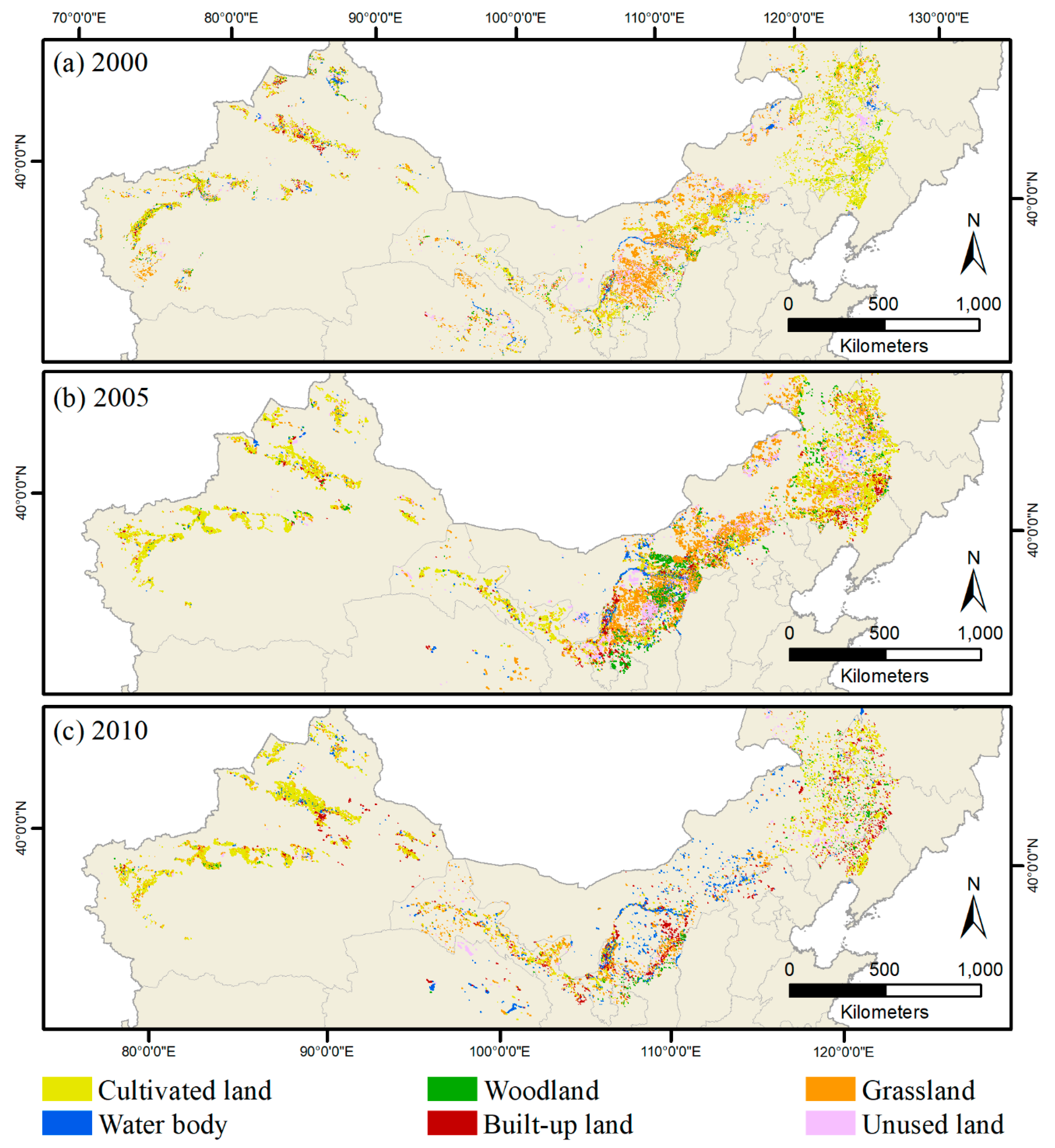
3.1. Land-Use Changes during 1995 to 2010
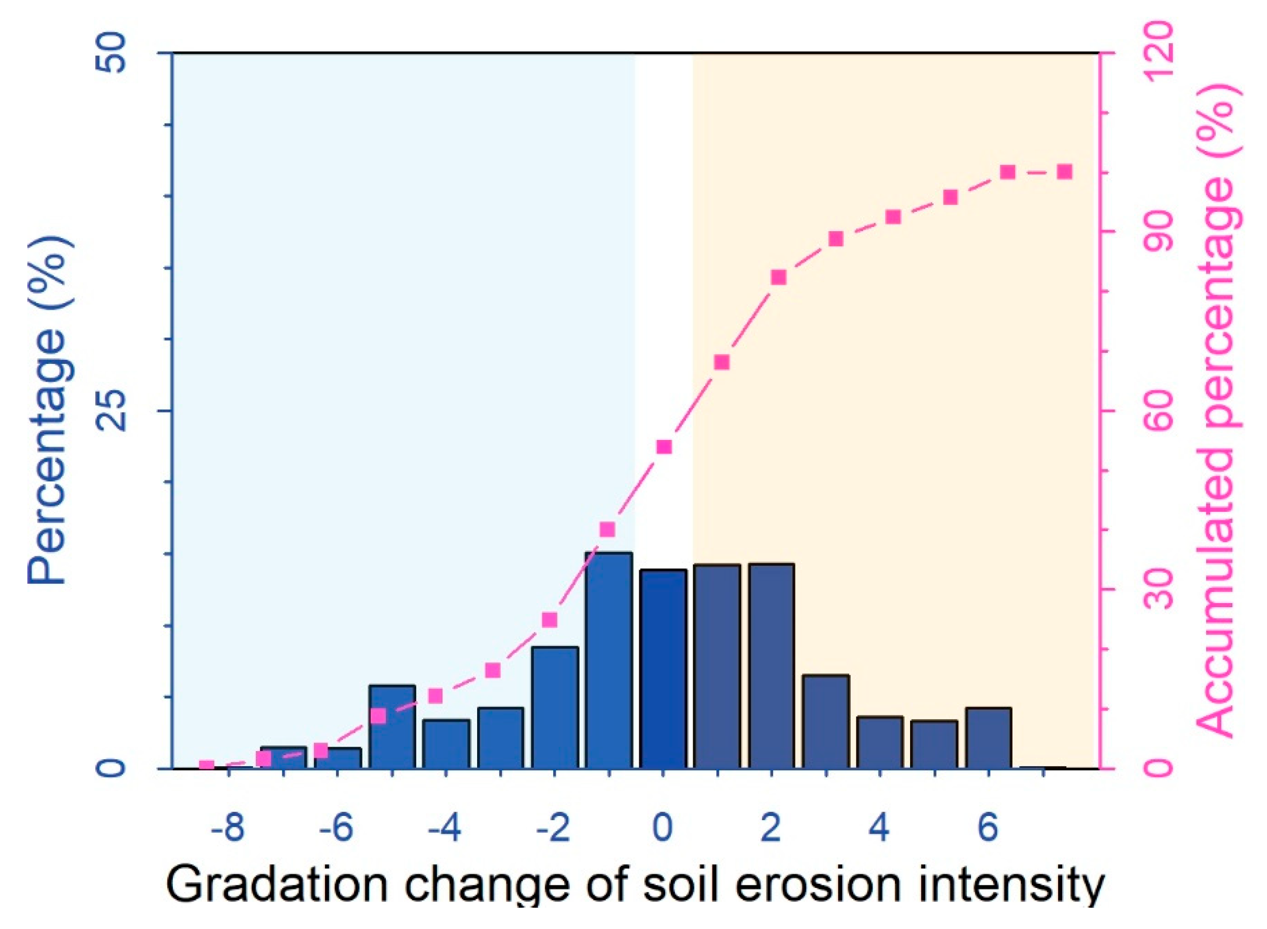
3.2. Dynamics of Soil Erosion During 1995 to 2010
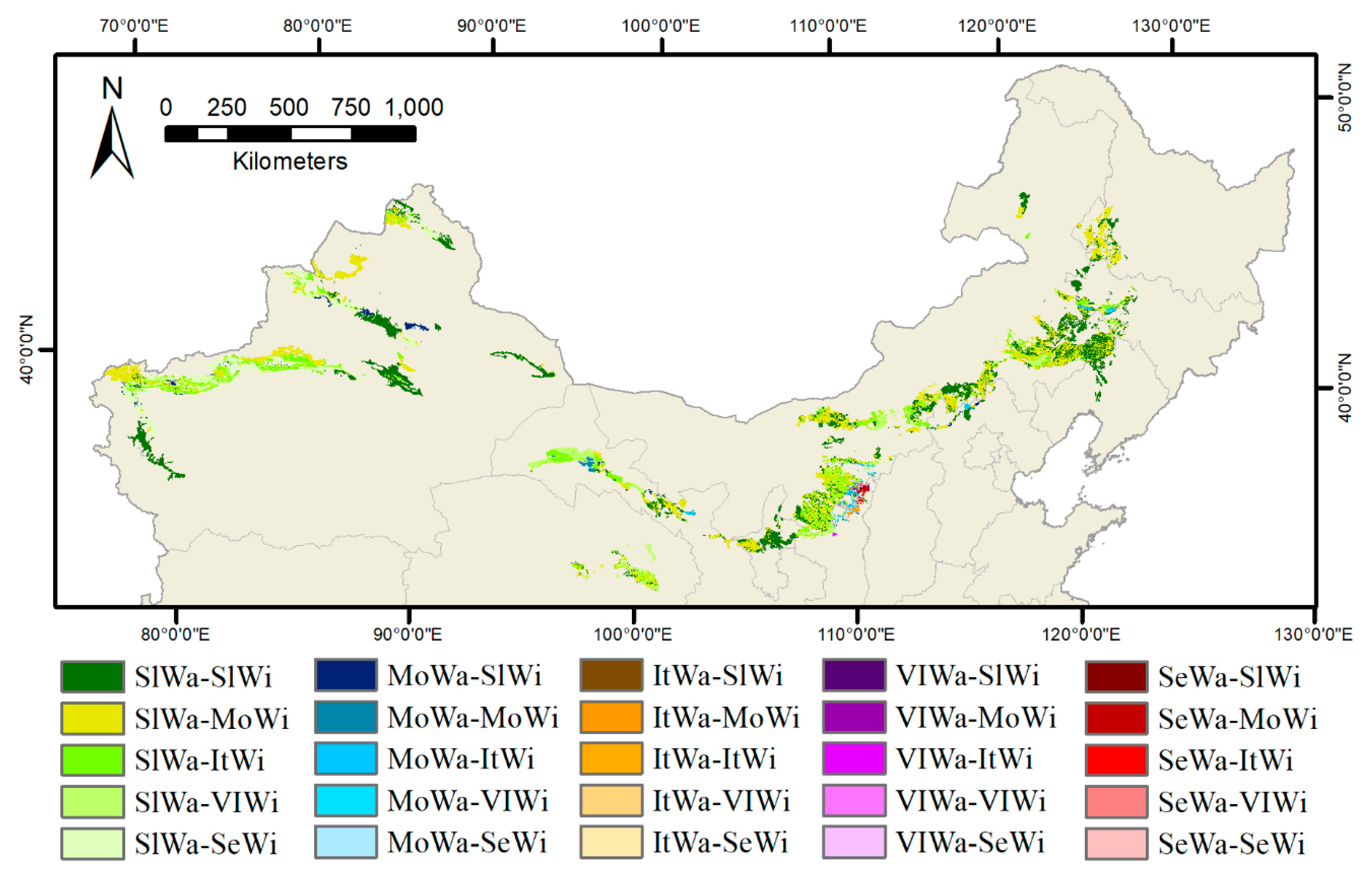
3.3. Contributions of Land-Use Changes to Soil Erosion Dynamics
4. Discussion
4.1. Soil Erosion in Water–Wind Crisscross Erosion Region During 1995–2010
4.2. Effects of Land Use Change on Soil Erosion
5. Conclusions
Supplementary Materials
Author Contributions
Funding
Acknowledgments
Conflicts of Interest
References
- Smith, P.; House, J.I.; Bustamante, M.; Sobocka, J.; Harper, R.; Pan, G.X.; West, P.C.; Clark, J.M.; Adhya, T.; Rumpel, C.; et al. Global change pressures on soils from land use and management. Glob. Chang. Biol. 2016, 22, 1008–1028. [Google Scholar] [CrossRef] [PubMed]
- Borrelli, P.; Robinson, D.A.; Fleischer, L.R.; Lugato, E.; Ballabio, C.; Alewell, C.; Meusburger, K.; Modugno, S.; Schütt, B.; Ferro, V.; et al. An assessment of the global impact of 21st century land use change on soil erosion. Nat. Commun. 2017, 8, 2013. [Google Scholar] [CrossRef]
- Doran, J.W.; Zeiss, M.R. Soil health and sustainability: Managing the biotic component of soil quality. Appl. Soil Ecol. 2000, 15, 3–11. [Google Scholar] [CrossRef]
- Gholoubi, A.; Emami, H.; Alizadeh, A. Soil quality change 50 years after forestland conversion to tea farming. Soil Res. 2018, 56, 509. [Google Scholar] [CrossRef]
- Pimentel, D.; Harvey, C.; Resosudarmo, P.; Sinclair, K.; Kurz, D.; Mcnair, M.; Crist, S.; Shpritz, L.; Fitton, L.; Saffouri, R.; et al. Environmental and Economic Costs of Soil Erosion and Conservation Benefits. Science 1995, 267, 1117–1123. [Google Scholar] [CrossRef] [PubMed]
- Wang, X.; Zhao, X.; Zhang, Z.; Yi, L.; Zuo, L.; Wen, Q.; Liu, F.; Xu, J.; Hu, S.; Liu, B. Assessment of soil erosion change and its relationships with land use/cover change in China from the end of the 1980s to 20010. Catena 2016, 137, 256–268. [Google Scholar] [CrossRef]
- Millward, A.A.; Mersey, J.E. Adapting the RUSLE to model soil erosion potential in a mountainous tropical watershed. Catena 1999, 38, 109–129. [Google Scholar] [CrossRef]
- Angima, S.; Stott, D.; O’Neill, M.; Ong, C.; Weesies, G.; Stott, D. Soil erosion prediction using RUSLE for central Kenyan highland conditions. Agric. Ecosyst. Environ. 2003, 97, 295–308. [Google Scholar] [CrossRef]
- Vanwalleghem, T.; Gomez, J.; Infante-Amate, J.; De Molina, M.G.; Vanderlinden, K.; Guzmán, G.; Laguna, A.; Giráldez, J. Impact of historical land use and soil management change on soil erosion and agricultural sustainability during the Anthropocene. Anthropocene 2017, 17, 13–29. [Google Scholar] [CrossRef]
- Chen, N.; Ma, T.; Zhang, X. Responses of soil erosion processes to land cover changes in the Loess Plateau of China: A case study on the Beiluo River basin. Catena 2016, 136, 118–127. [Google Scholar] [CrossRef]
- Liu, J.G.; Diamond, J. China’s environment in a globalizing world. Nature 2005, 435, 1179–1186. [Google Scholar] [CrossRef] [PubMed]
- Huang, J.; Rozelle, S. Environmental Stress and Grain Yields in China. Am. J. Agric. Econ. 1995, 77, 853. [Google Scholar] [CrossRef]
- Lu, Y.; Jenkins, A.; Ferrier, R.C.; Bailey, M.; Gordon, I.J.; Song, S.; Huang, J.; Jia, S.; Zhang, F.; Liu, X.; et al. Addressing China’s grand challenge of achieving food security while ensuring environmental sustainability. Sci. Adv. 2015, 1, e1400039. [Google Scholar] [CrossRef] [PubMed]
- Wang, H.; Jia, X.; Li, K.; Li, Y. Horizontal wind erosion flux and potential dust emission in arid and semiarid regions of China: A major source area for East Asia dust storms. Catena 2015, 133, 373–384. [Google Scholar] [CrossRef]
- Dong, Z.B.; Wang, X.M.; Liu, L.Y. Wind erosion in arid and semiarid China: An overview. J. Soil Water Conserv. 2000, 55, 439–444. [Google Scholar]
- Wang, L.Y.; Xiao, Y.; Rao, E.M.; Jiang, L.; Xiao, Y.; Ouyang, Z.Y. An Assessment of the Impact of Urbanization on Soil Erosion in Inner Mongolia. Int. J. Environ. Res. Public Health 2018, 15, 550. [Google Scholar] [CrossRef]
- Fu, B.J.; Wang, Y.F.; Lu, Y.H.; He, C.S.; Chen, L.D.; Song, C.J. The effects of land-use combinations on soil erosion: A case study in the Loess Plateau of China. Prog. Phys. Geogr. Earth Environ. 2009, 33, 793–804. [Google Scholar] [CrossRef]
- Li, X.; Nan, Z.; Wu, L.; Ran, Y.; Wang, J.; Pan, X.; Wang, L.; Li, H.; Zhu, Z. Environmental and Ecological Science Data Center for West China: Integration and sharing of environmental and ecological data. Adv. Earth Sci. 2008, 23, 628–637. [Google Scholar]
- Deng, L.; Shangguan, Z.P.; Li, R. Effects of the grain-for-green program on soil erosion in China. Int. J. Sediment Res. 2012, 27, 120–127. [Google Scholar] [CrossRef]
- Deng, L.; Liu, G.B.; Shangguan, Z.P. Land-use conversion and changing soil carbon stocks in China’s ‘Grain-for-Green’ Program: A synthesis. Glob. Chang. Biol. 2014, 20, 3544–3556. [Google Scholar] [CrossRef]
- Fu, B.; Liu, Y.; Lü, Y.; He, C.; Zeng, Y.; Wu, B. Assessing the soil erosion control service of ecosystems change in the Loess Plateau of China. Ecol. Complex. 2011, 8, 284–293. [Google Scholar] [CrossRef]
- Wang, J.; Zhang, W.; Zhang, Z. Quantifying the Spatio-Temporal Dynamics of Rural Settlements and the Associated Impacts on Land Use in an Undeveloped Area of China. Sustainability-(Basel) 2018, 10, 1490. [Google Scholar] [CrossRef]
- Liu, Y.; Fang, F.; Li, Y. Key issues of land use in China and implications for policy making. Land Use Policy 2014, 40, 6–12. [Google Scholar] [CrossRef]
- Lal, R. Soil Erosion by Wind and Water: Problems and Prospects. In Soil Erosion Research Methods; Routledge: Abingdon, UK, 2017; pp. 1–10. [Google Scholar]
- Zhao, G.; Mu, X.; Wen, Z.; Wang, F.; Gao, P. Soil Erosion, Conservation, And Eco-Environment Changes in the Loess plateau of China. Land Degrad. Dev. 2013, 24, 499–510. [Google Scholar] [CrossRef]
- García-Ruiz, J.M. The effects of land uses on soil erosion in Spain: A review. Catena 2010, 81, 1–11. [Google Scholar] [CrossRef]
- Renard, K.G.; Foster, G.R.; Weesies, G.; McCool, D.; Yoder, D. Predicting Soil Erosion by Water: A guide to Conservation Planning with the Revised Universal Soil Loss Equation (RUSLE); United States Department of Agriculture: Washington, DC, USA, 1997; Volume 703.
- Yang, D.; Kanae, S.; Oki, T.; Koike, T.; Musiake, K. Global potential soil erosion with reference to land use and climate changes. Hydrol. Process. 2003, 17, 2913–2928. [Google Scholar] [CrossRef]
- Ministry of Water Resources of the People’s Republic of China; Chinese Academy of Engineering. Soil Erosion Control and Ecological Security in China (Agro-pastoral Transitional Zone in Northern China); Science Press: Beijing, China, 2010.
- Li, Z.G. Quantitative Monitoring of Regional Soil Erosion; Northwest A&F University: Yangling, China, 2001. [Google Scholar]
- Yue, S.P.; Yang, R.X.; Yan, Y.C.; Yang, Z.W.; Wang, D.D. Spatial and temporal variations of wind erosion climatic erosivity in the farming-pastoral zone of Northern China. Theor. Appl. Clim. 2019, 135, 1339–1348. [Google Scholar] [CrossRef]
- Liu, Z.J.; Liu, Y.S.; Li, Y.R. Anthropogenic contributions dominate trends of vegetation cover change over the farming-pastoral ecotone of northern China. Ecol Indic 2018, 95, 370–378. [Google Scholar] [CrossRef]
- Song, Y.; Yan, P.; Liu, L. A review of the research on complex erosion by wind and water. J. Geogr. Sci. 2006, 16, 231–241. [Google Scholar] [CrossRef]
- Wang, Y.Q.; Shao, M.A. Spatial Variability of Soil Physical Properties in a Region of the Loess Plateau of Pr China Subject to Wind and Water Erosion. Land Degrad. Dev. 2013, 24, 296–304. [Google Scholar] [CrossRef]
- Zhang, Z.; Wang, X.; Zhao, X.; Liu, B.; Yi, L.; Zuo, L.; Wen, Q.; Liu, F.; Xu, J.; Hu, S. A 2010 update of National Land Use/Cover Database of China at 1:100000 scale using medium spatial resolution satellite images. Remote Sens. Environ. 2014, 149, 142–154. [Google Scholar] [CrossRef]
- Tucker, C.J. Red and photographic infrared linear combinations for monitoring vegetation. Remote Sens. Environ. 1979, 8, 127–150. [Google Scholar] [CrossRef]
- Ahl, D.E.; Gower, S.T.; Burrows, S.N.; Shabanov, N.V.; Myneni, R.B.; Knyazikhin, Y. Monitoring spring canopy phenology of a deciduous broadleaf forest using MODIS. Remote Sens. Environ. 2006, 104, 88–95. [Google Scholar] [CrossRef]
- Galvão, L.S.; Dos Santos, J.R.; Roberts, D.A.; Breunig, F.M.; Toomey, M.; De Moura, Y.M. On intra-annual EVI variability in the dry season of tropical forest: A case study with MODIS and hyperspectral data. Remote Sens. Environ. 2011, 115, 2350–2359. [Google Scholar] [CrossRef]
- McCool, D.K.; Brown, L.C.; Foster, G.R.; Mutchler, C.K.; Meyer, L.D. Revised Slope Steepness Factor for the Universal Soil Loss Equation. Trans. ASAE 1987, 30, 1387–1396. [Google Scholar] [CrossRef]
- Liu, J.; Liu, M.; Zhuang, D.; Zhang, Z.; Deng, X. Study on spatial pattern of land-use change in China during 1995–2000. Sci. China Ser. D Earth Sci. 2003, 46, 373–384. [Google Scholar]
- Gutman, G.; Ignatov, A. The derivation of the green vegetation fraction from NOAA/AVHRR data for use in numerical weather prediction models. Int. J. Remote Sens. 1998, 19, 1533–1543. [Google Scholar] [CrossRef]
- Jiang, L.; Xiao, Y.; Zheng, H.; Ouyang, Z. Spatio-temporal variation of wind erosion in Inner Mongolia of China between 2001 and 2010. Chin. Geogr. Sci. 2016, 26, 155–164. [Google Scholar] [CrossRef]
- Wang, J.; Xiao, X.; Bajgain, R.; Starks, P.; Steiner, J.; Doughty, R.B.; Chang, Q. Estimating leaf area index and aboveground biomass of grazing pastures using Sentinel-1, Sentinel-2 and Landsat images. Isprs. J. Photogramm. 2019, 154, 189–201. [Google Scholar] [CrossRef]
- Feng, X.M.; Wang, Y.F.; Chen, L.D.; Fu, B.J.; Bai, G.S. Modeling soil erosion and its response to land-use change in hilly catchments of the Chinese Loess Plateau. Geomorphology 2010, 118, 239–248. [Google Scholar] [CrossRef]
- Gessesse, B.; Bewket, W.; Brauning, A. Model-Based Characterization and Monitoring of Runoff and Soil Erosion in Response to Land Use/land Cover Changes in the Modjo Watershed, Ethiopia. Land Degrad. Dev. 2015, 26, 711–724. [Google Scholar] [CrossRef]
- Montgomery, D.R. Soil erosion and agricultural sustainability. Proc. Natl. Acad. Sci. USA 2007, 104, 13268–13272. [Google Scholar] [CrossRef] [PubMed]


| Level | Water Erosion | Wind Erosion |
|---|---|---|
| Slight | Water bodies, built-up areas, paddy fields, swampland; woodland or grassland with VC greater than 75% or slope less than 5°; cultivated land with slope less than 5° | Water bodies, paddy fields, built-up areas, swampland; SC is less than 55% and VC is greater than 50% |
| Light | Woodland or grassland with VC of 60%–75% and slope of 5°–25°; VC of 45%-60% and slope of 5°–15°; VC of 30%–45% and slope of 5°–8°; cultivated land with slope of 5°–8° | SC is less than 55% and VC is of 20%–50%; SC is greater than 55% and VC is greater than 70% |
| Moderate | Woodland or grassland with VC of 60%–75% and slope larger than 25°; VC of 45%–60% and slope of 15°–35°; VC of 30%–45% and slope of 8°–15°; VC less than 30% and slope less than 15°; cultivated land with slope of 8°–15° | SC is less than 55% and VC is of 10%–20%; SC is greater than 55% and VC is of 50%–70% |
| Intensive | Woodland or grassland with VC of 45%–60% and slope larger than 35°; VC of 30% - 45% and slope of 25°–35°; VC less than 30% and slope of 15°–25°; cultivated land with slope of 15°–25° | SC is greater than 55% and VC is of 5%–10%; built-up area under construction; saline-alkali land |
| Very intensive | Woodland or grassland with VC of 30%–45% and slope larger than 35°; VC less than 30% and slope of 25°–35°; cultivated land with slope of 25°–35° | SC is greater than 55% and VC is of 5% - 10% and VC is of 1%–5%; bare land with SC less than 55% |
| Severe | Woodland or grassland with VC less than 30% and slope greater than 35°; cultivated land with slope greater than 35°; loess plateau in broken terrain with VC less than 10%, bare soil with slope greater than 8° or sand with slope greater than 25° | SC is greater than 55% and VC is less than 1%; Gobi Desert, and bare soil with SC greater than 55% |
| CL | WL | GL | WB | BU | UL | |||||||||||||
|---|---|---|---|---|---|---|---|---|---|---|---|---|---|---|---|---|---|---|
| 1st | 2nd | 3rd | 1st | 2nd | 3rd | 1st | 2nd | 3rd | 1st | 2nd | 3rd | 1st | 2nd | 3rd | 1st | 2nd | 3rd | |
| CL | 0 | 0 | 0 | 78.9 | 151.3 | 27.3 | 472.2 | 680.5 | 85.3 | 6.9 | 5.6 | 5.7 | 11.1 | 26.3 | 29.1 | 80.2 | 153.5 | 7.1 |
| WL | 87.0 | 50.5 | 15.02 | 0 | 0 | 0 | 12.8 | 57.2 | 8.1 | 1.5 | 1.5 | 0.2 | 0.4 | 2.9 | 2.4 | 5.9 | 16.2 | 3.7 |
| GL | 1942.2 | 863.3 | 511.5 | 77.0 | 274.4 | 6.4 | 0 | 0 | 0 | 60.4 | 19.4 | 13.4 | 49.5 | 64.7 | 93.1 | 715.7 | 934.5 | 165.0 |
| WB | 0 | 0 | 0 | 0 | 0 | 0 | 0 | 0 | 0 | 0 | 0 | 0 | 0 | 0 | 0 | 0 | 0 | 0 |
| BU | 0 | 0 | 0 | 0 | 0 | 0 | 0 | 0 | 0 | 0 | 0 | 0 | 0 | 0 | 0 | 0.2 | 0 | 0 |
| UL | 55.4 | 352.2 | 340.8 | 34.9 | 42.0 | 3.1 | 264.1 | 295.3 | 383.1 | 19.1 | 12.4 | 36.4 | 22.3 | 31.7 | 58.9 | 0 | 0 | 0 |
© 2019 by the authors. Licensee MDPI, Basel, Switzerland. This article is an open access article distributed under the terms and conditions of the Creative Commons Attribution (CC BY) license (http://creativecommons.org/licenses/by/4.0/).
Share and Cite
Wang, J.; Zhang, W.; Zhang, Z. Impacts of Land-Use Changes on Soil Erosion in Water–Wind Crisscross Erosion Region of China. Remote Sens. 2019, 11, 1732. https://doi.org/10.3390/rs11141732
Wang J, Zhang W, Zhang Z. Impacts of Land-Use Changes on Soil Erosion in Water–Wind Crisscross Erosion Region of China. Remote Sensing. 2019; 11(14):1732. https://doi.org/10.3390/rs11141732
Chicago/Turabian StyleWang, Jie, Weiwei Zhang, and Zengxiang Zhang. 2019. "Impacts of Land-Use Changes on Soil Erosion in Water–Wind Crisscross Erosion Region of China" Remote Sensing 11, no. 14: 1732. https://doi.org/10.3390/rs11141732
APA StyleWang, J., Zhang, W., & Zhang, Z. (2019). Impacts of Land-Use Changes on Soil Erosion in Water–Wind Crisscross Erosion Region of China. Remote Sensing, 11(14), 1732. https://doi.org/10.3390/rs11141732