


Abstract
Objective: Given the global trend of ecological protection and sustainable development, Global Geoparks have become an essential platform for resource conservation and regional growth. Changzhi City in Shanxi Province, China, is actively applying for Global Geopark status, relying on its rich geoheritage sites, cultural history, and natural landscapes. This paper presents a systematic evaluation of the city’s geodiversity and relic value, analyzes the feasibility of establishing a Global Geopark in Changzhi City, and provides scientific support for Changzhi City’s Global Geopark application. Methods: Geodiversity data were collected by region using a 1:25,000 grid for sampling. Four methods were adopted for evaluation, namely, the Shannon diversity index, Simpson diversity index, entropy weight method (EWM), and Pielou evenness index. Upon comprehensive comparison of the four approaches, the most suitable approach was selected to produce the final results. For the value evaluation of the geoheritage, a combination of the analytic hierarchy process and the entropy weight method was employed. Results: (1) According to the results of all four methods, the geodiversity of Changzhi City is higher in the eastern and western regions and lower in the central area. (2) The geoheritage sites are mainly distributed in the eastern part of the city and have relatively high relic value. (3) Changzhi City contains abundant natural reserves and cultural resources, meeting the fundamental requirements for Global Geopark construction. Specifically, 38 townships across eight counties were identified as potential geopark areas, encompassing 54 geoheritage sites, 76 provincial-level or higher cultural-relic protection sites, and 15 provincial-level or higher natural protected areas, with a total area of 4458.51 km2. Conclusions: Our results suggest that the Shannon diversity index is an effective tool for evaluating geodiversity in Changzhi City. Based on the region’s geological and natural conditions, the delineated geopark area is feasible. In summary, our findings provide essential references for the protection and sustainable development of geoheritage sites, geodiversity, and geoparks and offer strong theoretical and data support for Changzhi City’s Global Geopark application.
1. Introduction
The 41st United Nations Educational, Scientific, and Cultural Organization (UNESCO) General Conference in 2021 designated 6 October as International Geodiversity Day, marking a shift in the global understanding of geodiversity from theoretical research to practical application. Geodiversity focuses on rocks, minerals, fossils, landforms, soils, and their interrelationships. It forms the foundation of Earth’s life systems. It not only influences the formation of soil, vegetation, and animal communities in ecosystems but also becomes integrated into human life through interactions with socio-cultural factors [1]. Geodiversity assessment is the cornerstone of scientific development, protection, and management of geological resources. Scientific assessment methods can provide data support for policymaking and can contribute to sustainable development [2,3]. In geodiversity assessment, grid-based statistical methods are widely applied [4,5,6,7], and most approaches often combine qualitative and quantitative analyses [8,9,10]. In recent years, the α, β, and γ assessment framework from biodiversity studies has been introduced into geodiversity assessment. Tukiainen et al. [11] applied this framework to evaluate geodiversity and analyzed the geological characteristics using nonmetric multidimensional scaling (NMDS). They found that geological diversity is correlated with biodiversity, offering a novel approach to geological conservation. They also emphasized the need to standardize existing indicators. Wang et al. [12] calculated the Shannon diversity index and Rao’s quadratic entropy in the Lancang–Mekong River Basin, demonstrating that geodiversity can explain the variations in the fish diversity in this region. Thus, they proposed conservation strategies using geodiversity as a proxy indicator. However, current research still lacks a unified and universally applicable evaluation system.
Chinese geoheritage sites are an important component of global geodiversity, which are resource-rich, diverse, and widely distributed [13]. These geoheritages span multiple disciplines—such as geography, structural geology, and petrology—and they hold great significance for studying Earth’s evolution and biodiversity and for science education. Geodiversity and geoheritage are closely connected: understanding the former helps explain the origins and evolution of the latter, while the latter provides empirical data for analyzing the former [14,15,16]. Evaluation of geoheritage originated in the 1960s and evolved from single qualitative assessments to multi-factor quantitative analyses. Currently, most studies use refined quantitative methods [17,18,19,20,21]. However, quantitative analyses often overlook non-measurable factors, while qualitative evaluations are prone to subjectivity. Therefore, it is essential to establish a comprehensive evaluation system that integrates both subjective and objective factors, improving the scientific rigor and reliability of evaluations by combining the precision of quantitative methods with the comprehensiveness of qualitative analysis [22].
In recent years, research on geodiversity and geoheritage has developed rapidly, promoting geological tourism, ecological conservation, and international geological cultural exchange, as well as facilitating the construction of geological parks [23,24,25]. China has been one of the earliest and most active participants in the Global Geoparks initiative and places great emphasis on geoheritage protection. As of October 2025, China has 49 Global Geoparks—the highest number worldwide—distributed across 23 provinces (autonomous regions and municipalities) and the Hong Kong Special Administrative Region. The division of geoparks primarily depends on the scientific, esthetic, rarity, integrity, and ecological values of geoheritage. Among these, scarcity and scientific significance are the core criteria for park designation. Geodiversity assessment provides technical support for geopark delineation, while geopark management measures, by supporting the conservation of geodiversity and geoheritage sites, form a sustainable development model of value identification, diversity quantification, and protection implementation [26,27,28,29,30].
Changzhi City in Shanxi Province, China, is actively applying for UNESCO Global Geopark status. Located at the southeastern edge of the Loess Plateau, the city’s unique terrain is a basin flanked by two mountain ranges, which, through long-term geological evolution, has shaped a diverse range of geoheritage. This includes paleontological fossils, peak clusters, gorges, well-developed karst landscapes, and abundant springs, which harbor geoheritage of global significance. To scientifically advance the application process, establishing a systematic evaluation framework is essential for delineating the proposed park boundaries and informing related decision-making.
In this paper, we address three core issues—methodological suitability, current state assessment, and spatial integration—to construct a systematic evaluation and spatial decision-making framework tailored for Changzhi City, thereby filling the research gap in comprehensive assessments of the region’s geodiversity and geoheritage. First, we employ an integrated analytic hierarchy process (AHP) and entropy weight method to conduct a combined subjective and objective comprehensive evaluation of the geoheritage sites. Second, based on grid-based zoning and multi-source data collection, we systematically compare and select the optimal quantitative method for assessing the geodiversity from among the Shannon diversity index, Simpson diversity index, entropy weight method, and Pielou’s evenness index. Finally, the framework integrates the evaluation results of the geoheritage value and geodiversity to scientifically delineate the proposed boundary for the Global Geopark.
This system not only provides direct and reliable quantitative evidence to support Changzhi City’s Global Geopark application, facilitating the synergistic protection of geoheritage and the ecological environment, but through the systematic assessment of geological resources, it also offers scientific support for regional geoscience education, sustainable tourism, and socio-economic development. This promotes the deep integration of geological cultural heritage with regional development.
2. Study Area
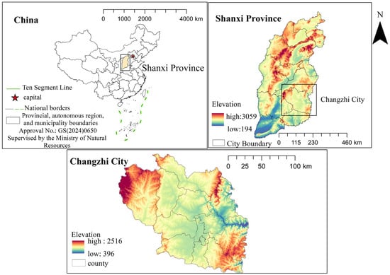
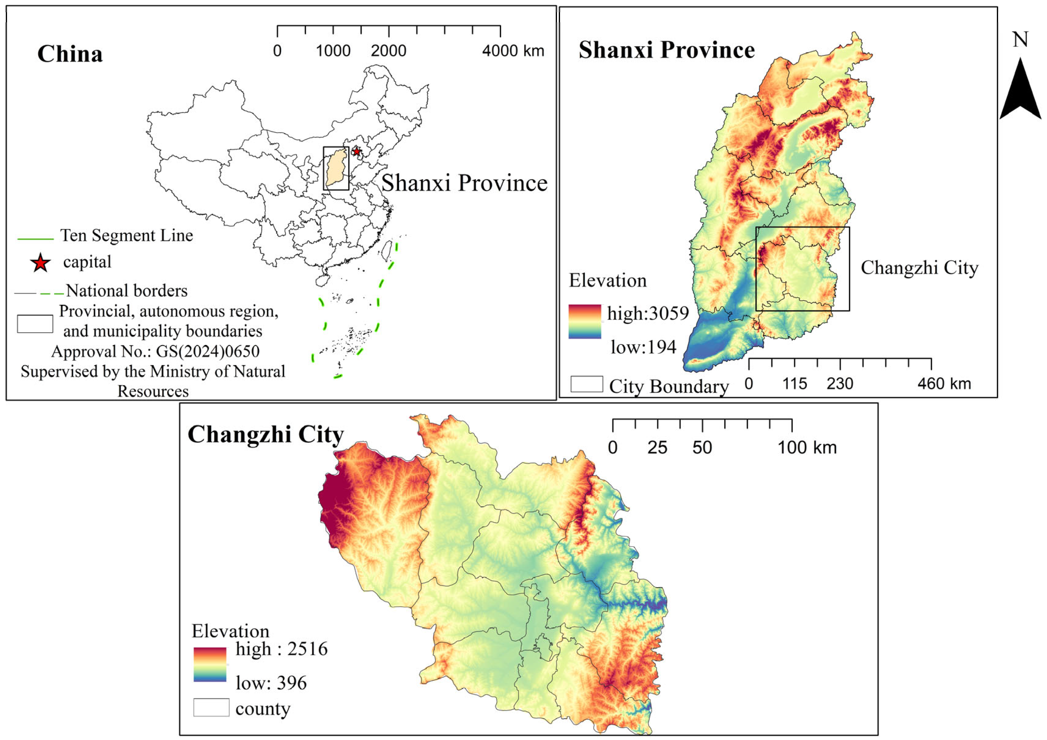
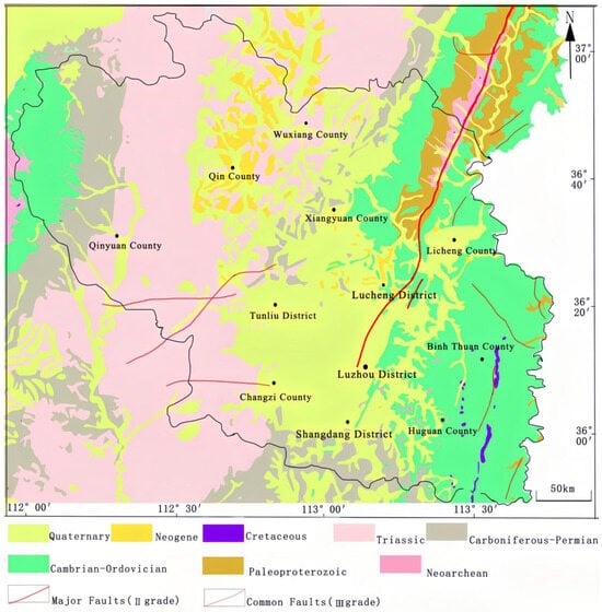
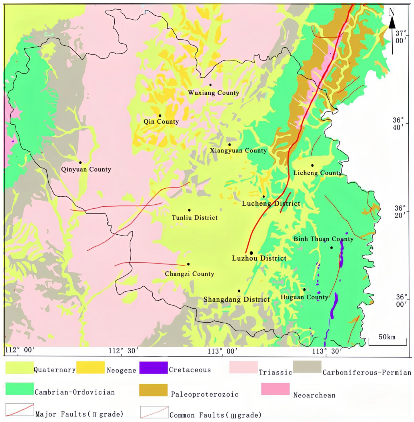
The topography of Changzhi City is characterized by undulating mountains and complex terrain. Its landforms can be classified into four types: mountains, hills, basins, and valleys (Figure 1). The vegetation mainly consists of mixed coniferous and broad-leaved forests, interspersed with shrubs and herbaceous plants. More than 20 species of wild plants are under national and provincial protection. The forest coverage is 26.82%, ranking second in the province. Moreover, Changzhi has a warm temperate continental climate, with mild dry conditions, clear seasonal variations, and abundant water resources. The major rivers in the region include the Zhuozhang River, Qingzhang River, and Wei River in the Haihe River Basin, and the Qin River in the Yellow River Basin. The city’s average annual temperature is 9.1 °C, and the average annual precipitation is 618.9 mm [31]. According to the 1:250,000 geological survey report for Changzhi City (J49C004004), the exposed metamorphic strata belong to the Neoarchean Zanhuang Group, the sedimentary cover includes the Paleoproterozoic Great Wall System, the Paleozoic Cambrian, Ordovician, Carboniferous, and Permian systems, the Mesozoic Triassic system, and the Cenozoic Neogene and Quaternary systems (Figure 2).
Figure 1.
Changzhi City location map.
Figure 2.
Geological map of Changzhi City.
3. Materials and Methods
3.1. Geodiversity Assessment
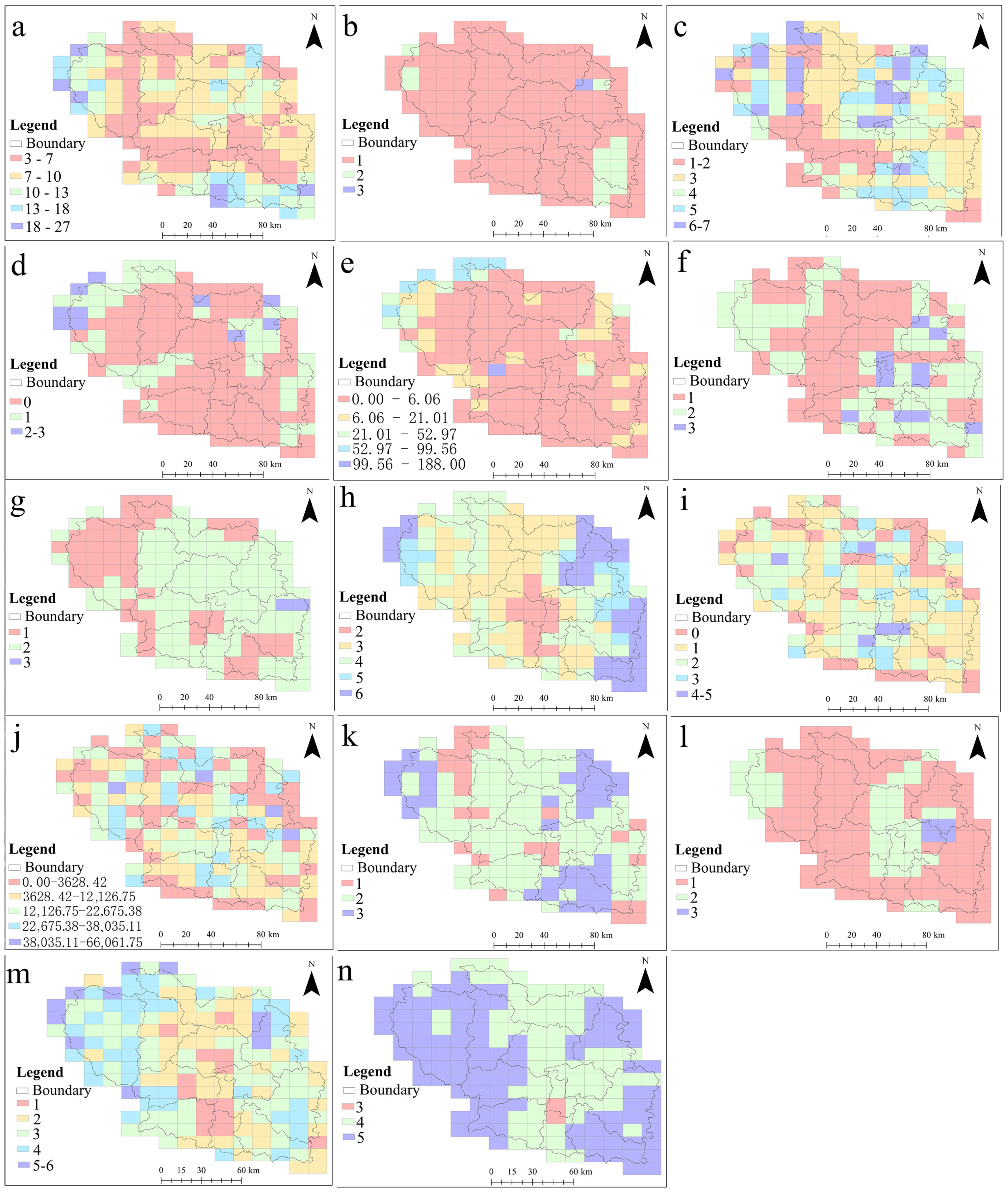
In this study, we established an evaluation index system for geodiversity in Changzhi City, Shanxi Province [32,33,34,35,36,37,38,39,40,41,42]. The system consists of four layers: the target layer, the comprehensive layer (geological elements and manifestations), the element layer (strata and rocks, structures, geomorphological diversity, surface water, groundwater, and plant diversity), and the factor layer (number of lithostratigraphic units, rock types, number of geological ages, number and length of structures, soil types, geomorphological types, slope grade types, number and length of rivers, groundwater types, water abundance, and vegetation types and coverage). The details are presented in Table 1.
Table 1.
Geodiversity evaluation factors and entropy-weight values in Changzhi City.
Compared with the evaluation system proposed by Xiong Jihong [32], in this study, we added a hydrological evaluation layer to incorporate hydrological elements into the indicators. This addition draws on the research of Miros Gómez et al. [38], and the fact that the geodiversity evaluation systems of researchers such as Scammacca et al. [39], Ahmadi et al. [40], and Dias et al. [41] all include hydrological elements further supports its necessity. Furthermore, compared to the evaluation system of Miros Gómez et al. [42], in this study, we added a plant species evaluation layer to more comprehensively reflect the biological aspects of the geodiversity. This aligns with the evaluation approach in Xiong Jihong’s [32] system, which includes biological factors. Limited by practical survey conditions, we did not include an animal species evaluation layer. In future work, we will consider incorporating factors such as animal species, climate, and precipitation to build a more comprehensive evaluation system for a holistic analysis of geodiversity.
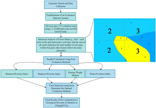
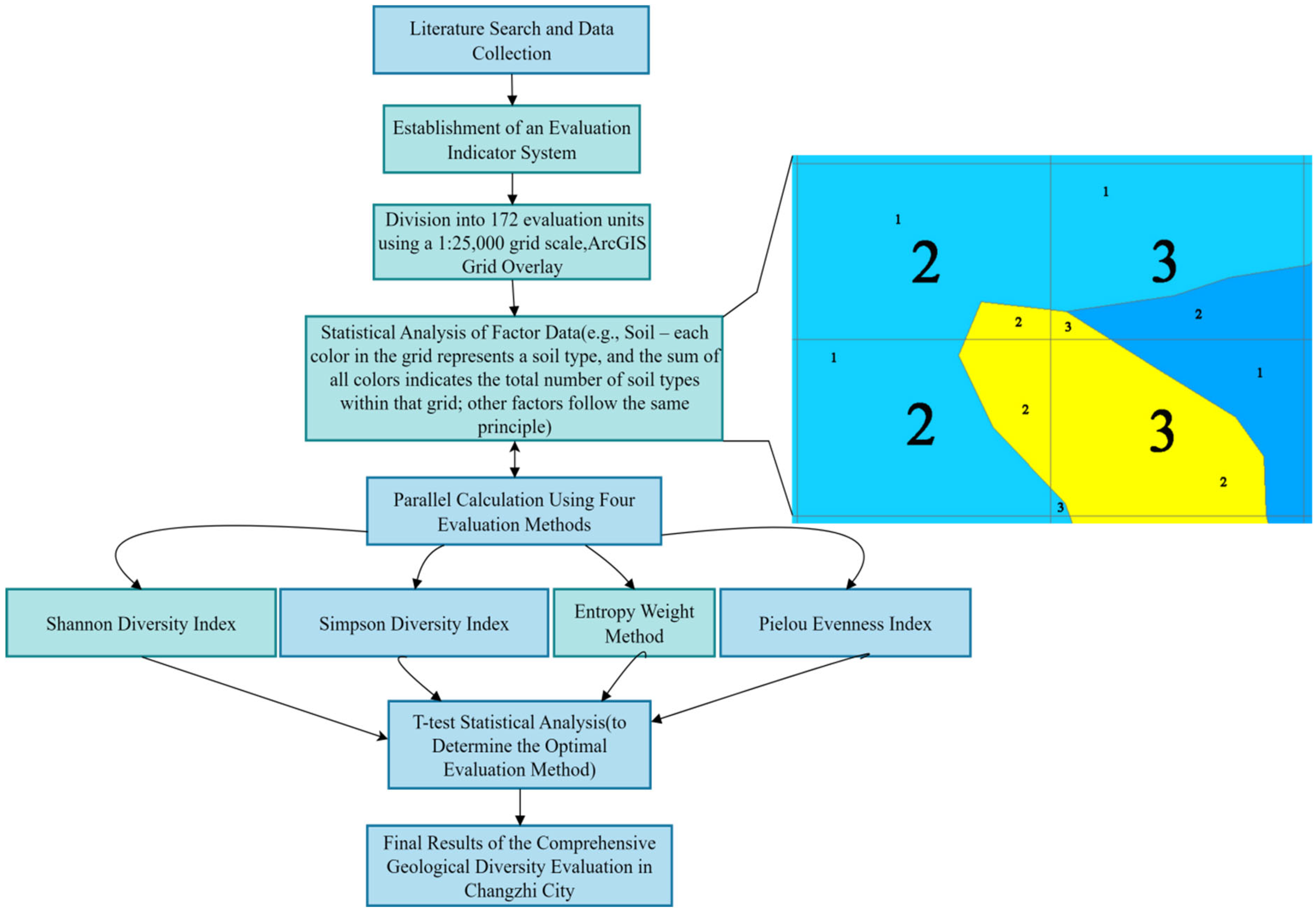
Regarding the zoning method, in this study, we employed grid analysis (also known as fishnet analysis) to partition Changzhi City. The advantage of this method lies in its flexibility to adjust the grid size according to the study area, making it suitable for evaluations at different scales, and it has widespread application in geodiversity assessments [4,9]. The specific operation followed the quantitative method proposed by Pereira et al. [37] and improved by scholars such as Bétard [43] and Menezes [44]. This involves overlaying a grid onto thematic maps of each indicator and counting the values of various geodiversity indicators within each grid cell. The statistical method is illustrated in Figure 3. Taking soil types as an example, each color in the figure represents one type, and the sum of all of the types within a grid cell constitutes the total number of soil types for that cell. The statistical methods for the other data are similar. Based on the area of Changzhi City (approximately 14,000 km2) and considering research experience regarding the spatial scale in regional geodiversity evaluation, in this study, we used a 1:25,000 scale for the grid division, resulting in 172 grid cells with an average area of about 81 km2. This scale selection references the work of Lopes et al. [45] on mainland Portugal, which suggests that grid cells of 25–100 km2 can effectively balance detailed information with overall patterns in regional-scale assessments. From an international perspective, the grid size typically corresponds to the scale of the study area: for instance, for the Slovak mountainous region [46] (about 5000 km2), 25 km2 grids were used, while for the state of Paraná, Brazil [37] (about 200,000 km2), 625 km2 grids were used. The area considered in this study falls between these two, and the chosen 81 km2 grid cell is within the recommended range. It ensures that there is sufficient geological information within each unit while keeping the total number of units manageable for systematic analysis, thus balancing scientific rigor and practicality.
Figure 3.
Geodiversity Evaluation Flowchart. The four grids on the right side of the flowchart represent soil types. Each color in the figure denotes one type, and the sum of the quantities of all types within a grid equals the total number of soil types for that grid.
To comprehensively and scientifically evaluate geodiversity, in this study, we selected four methods for calculation: the Shannon diversity index, the Simpson diversity index, the entropy weight method, and the Pielou evenness index. The Shannon index, based on information entropy theory, reflects the richness of the geological types. The Simpson index focuses on measuring the dominance of the predominant types and their contribution to the overall diversity. The entropy weight method objectively determines the indicator weights based on data dispersion, enhancing the scientific nature of the evaluation. The Pielou index is used to assess the evenness of the spatial distribution of the various geological types. To compare the applicability of each method in this local evaluation, a T-test will subsequently be performed on the results obtained from the four methods to identify the one that most accurately and comprehensively reflects the true state of the geodiversity in Changzhi City.
The evaluation process is shown in Figure 3, and the data sources are listed in Table 2. The data processing and mapping were performed using ArcGIS 10.7. Each grid cell was evaluated using the four methods mentioned above, ultimately yielding the geodiversity evaluation results for Changzhi City.
Table 2.
Data source.
3.2. Evaluation of Geoheritage
The AHP has commonly been used to determine the index weights for the evaluation of geoheritage [48,49]. To improve the scientific rigor and rationality of the evaluation, in this study, we combined the weights of the geoheritage indices obtained via the AHP with those obtained using the entropy weight method (EWM), and the combined weights were used as the final weights.
The indices for the geoheritage evaluation were divided into three layers: a target layer, a comprehensive layer (e.g., natural attributes, value attributes, and protection conditions), and an index layer (e.g., typicality, rarity, integrity of the natural system, scientific value, esthetic value, socio-economic value, degree of preservation, and protectability).
In this study, 65 geoheritage sites in Changzhi City were evaluated and graded (Table A3) by five geological experts from Shanxi Province. Fuzzy scoring was applied, with a full score of 100 points for each index, which was divided into four levels: Level 1 (90–100 points), Level 2 (80–89 points), Level 3 (70–79 points), and Level 4 (≤69 points). The final score for each site was calculated as the arithmetic mean of the five experts’ total scores. The experts used Saaty’s scale of 1–9 [50,51] to determine the weights of the geoheritage evaluation indices (Table 3). The results were processed using the Yaahp 10.3 software, and the AHP weights were derived through its group decision function. The AHP weights and the EWM weights, which were calculated using EvaGear 2.7.8389 software, were then combined using Equation (1) to obtain the final weights. Then, the comprehensive value for each geoheritage site was calculated using Equation (2). Thus, the final evaluation outcomes for all of the geoheritage sites in Changzhi City were obtained. The geoheritage and geodiversity evaluation results were compared to identify similarities and differences, interpret the causes of the variations, and discuss the feasibility of establishing a Global Geopark in Changzhi City. In this study, the data processing was conducted using ArcGIS 10.7 (Esri, Redlands, CA, USA), MapGIS 6.7 (Zondy Cyber Group, Wuhan, China), Excel 2021 (Microsoft Corporation, Redmond, WA, USA), Yaahp 10.3 (Beijing Jinjing Wuxian Technology Co., Ltd., Beijing, China), EvaGear 2.7.8389 (Institute of Geographic Sciences and Natural Resources Research, CAS, Beijing, China, and SPSS Statistics 26 (IBM Corporation, Armonk, NY, USA).
where is the final weight of the ith index, is the EWM weight of the ith index, is the AHP weight of the ith index, and γ is the weight factor (γ = 0.5 in this study).
where is the final score of the evaluated object, i is the ith index, n is the total number of indices, is the overall weight of the indices, and is the fuzzy score of the indices.
Table 3.
Meaning of the Importance Scale.
Based on the comprehensive scores of the indices for geoheritage evaluation and with reference to the Classification, Investigation, and Evaluation of Tourism Resources (GB/T 18972-2017) [52] and the Specification for Geoheritage Investigation (DZ/T0303-2017) [53] of the People’s Republic of China (Table A1), the evaluation results were classified into four levels: global-level geoheritage sites (90–100 points), national-level sites (80–89 points), provincial-level sites (70–79 points), and sub-provincial level sites (≤69 points) [49,54].
4. Results
4.1. Geodiversity Distribution
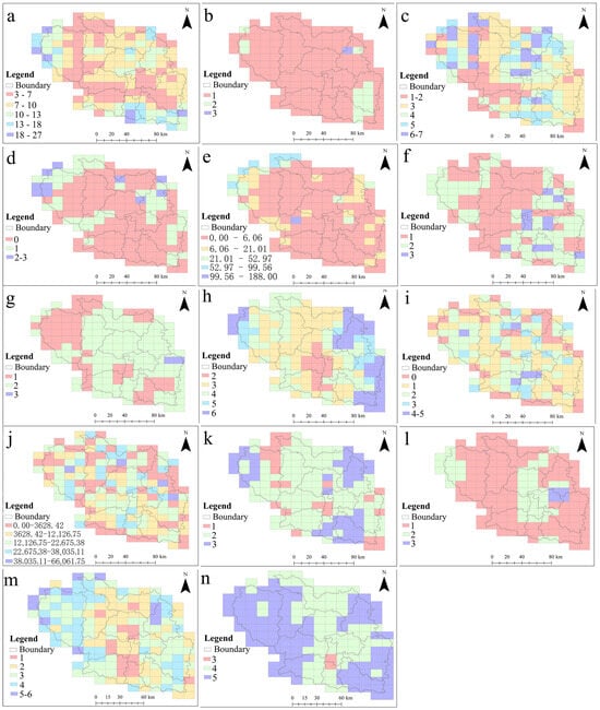
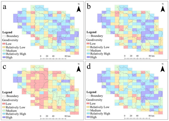
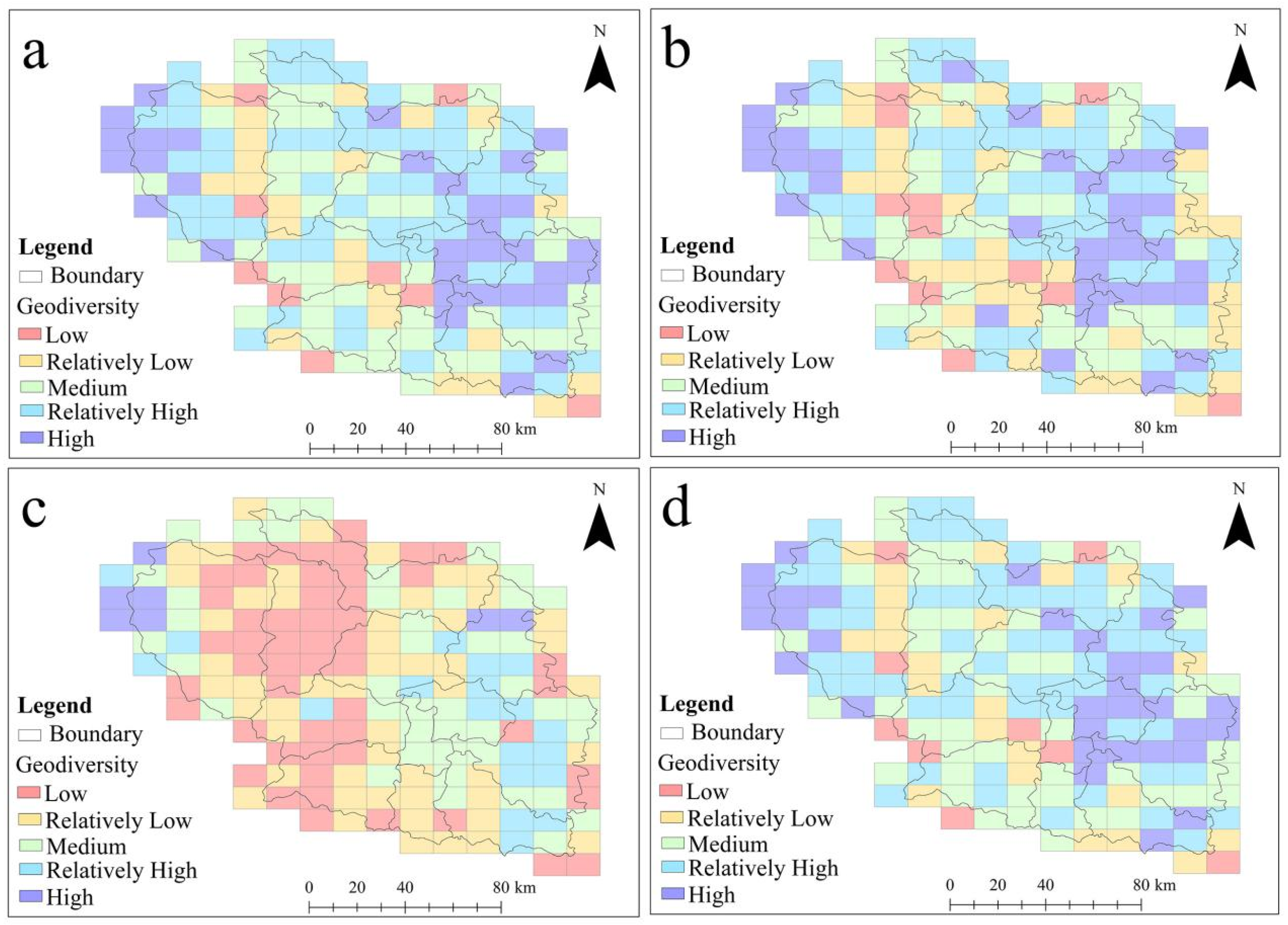
The classification of each evaluation indicator is presented in Figure 4. The geodiversity assessment results, calculated using the Shannon, Simpson, entropy weight, and Pielou methods, were classified into five levels—low, relatively low, medium, relatively high, and high—applying the natural breaks (Jenks) method in ArcGIS (Figure 5).
Figure 4.
Geodiversity indicator map of Changzhi City. (a) Number of Lithostratigraphic Units. (b) Rock Types. (c) Number of geological ages. (d) Number of constructions. (e) Length of the structure. (f) Soil type. (g) Types of landforms. (h) Slope grade type. (i) Number of rivers. (j) River length. (k) Groundwater type. (l) Groundwater water abundance. (m) Vegetation type. (n) Vegetation coverage.
Figure 5.
Evaluation results of the four methods: (a) Shannon, (b) Simpson, (c) entropy-weighted method, (d) Pielou.
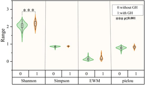
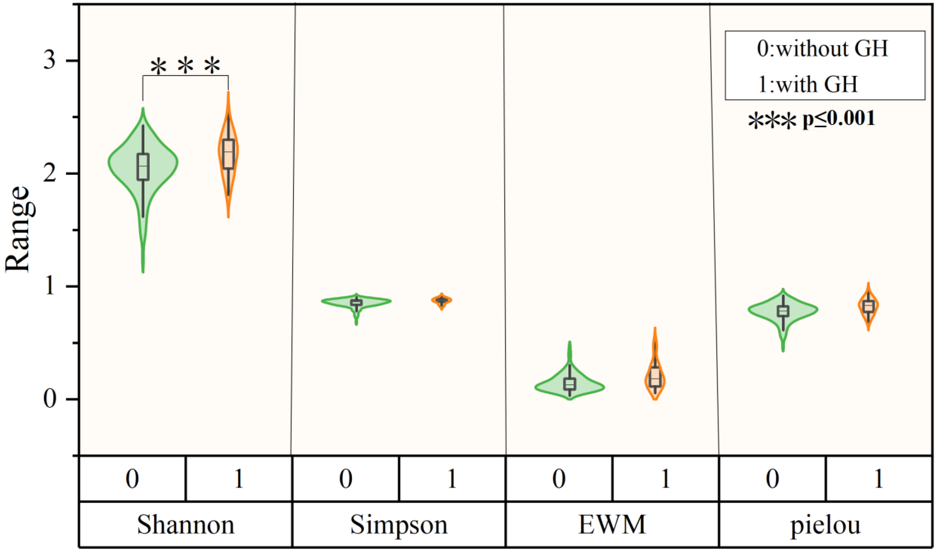
Based on a comprehensive understanding of the spatial distribution of the geoheritage sites, independent sample t-tests were applied to evaluate the performances of the four diversity indices in distinguishing between areas with and without geoheritage (Figure 6). GH stands for geological heritage. The results indicate that the Shannon diversity index was significantly different between areas with and without geoheritage, while the EWM, Simpson, and Pielou indices were not significantly different.
Figure 6.
The independent sample t-test results for the four evaluation methods based on geoheritage.
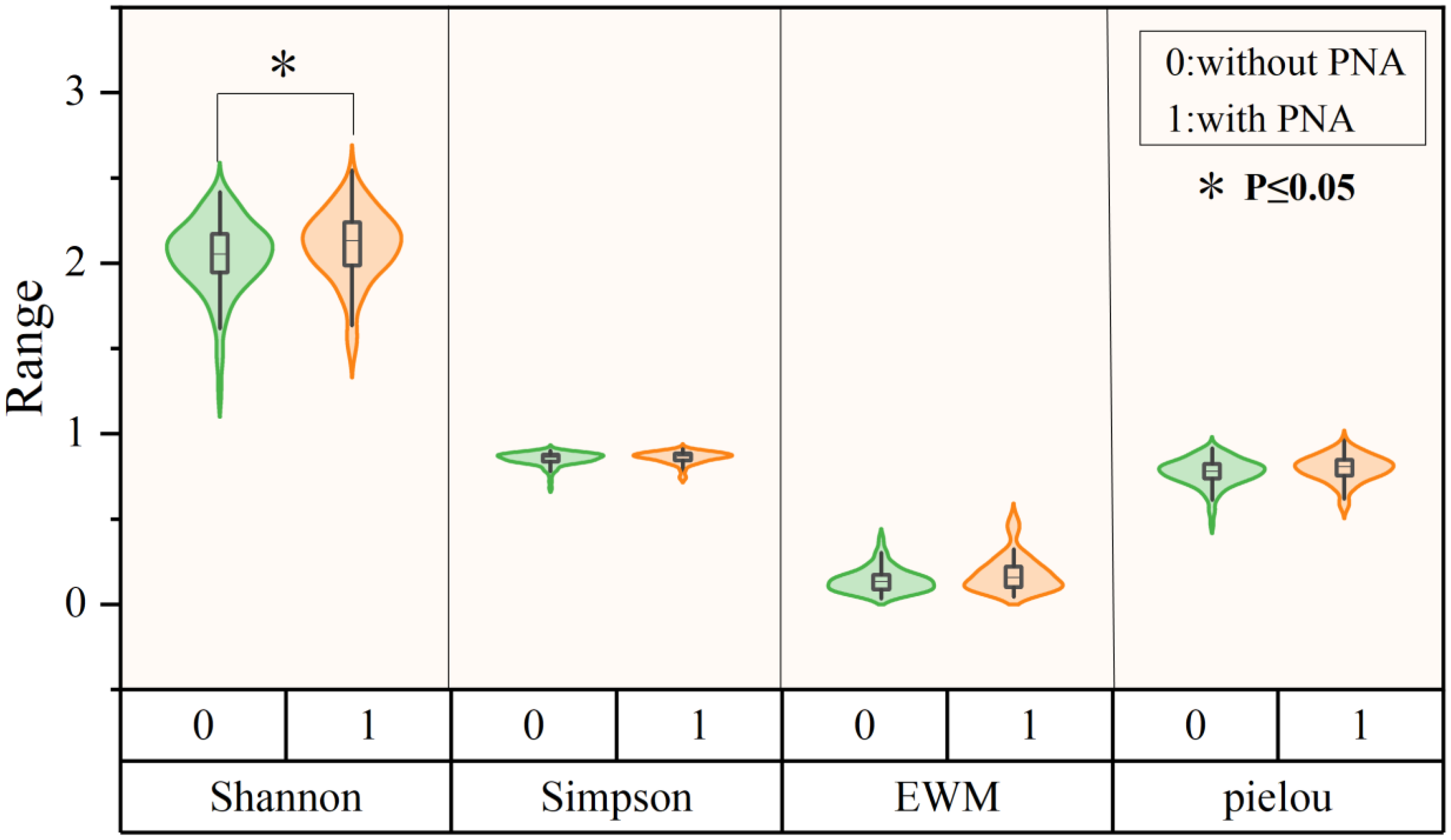
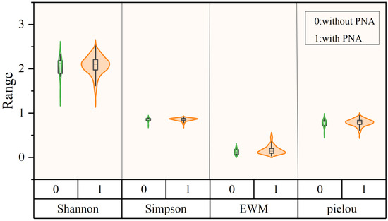
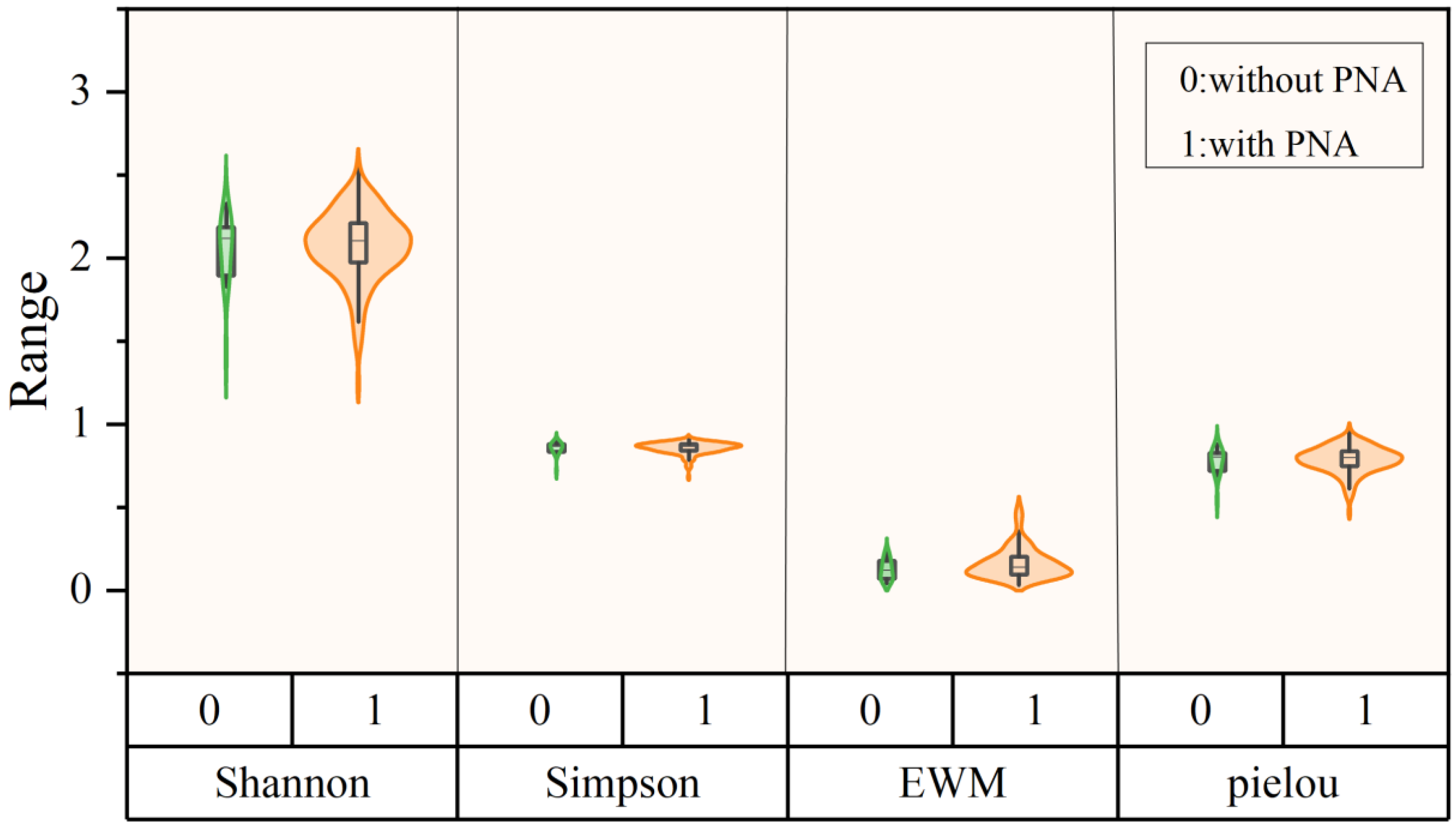
Changzhi City has abundant natural resources, with 34 nature reserves, including nine national-level and 25 provincial-level reserves. These include three geoparks, 12 scenic areas, 12 forest parks, five wetland parks, and two nature reserves, covering approximately 1413.011 km2 (Table A2). Based on this distribution, the four evaluation methods were compared (Figure 7). PNA stands for protected natural areas. The Shannon diversity index showed a significant difference between protected and non-protected areas, while the other three methods did not show significant differences. Considering the high ecological diversity around the reserves, to assess their ecological radiation effect, data from four adjacent grids (above, below, left, and right of each protected area) were included in the analysis and simulated as a protected area. The results of the independent samples t-tests comparing the areas with and without ecological radiation revealed that there were no significant differences among the four evaluation methods (Figure 8).
Figure 7.
Independent sample t-test results of the four evaluation methods based on nature reserves.
Figure 8.
Results of the independent sample T-test of four evaluation methods based on ecological radiation in nature reserves.
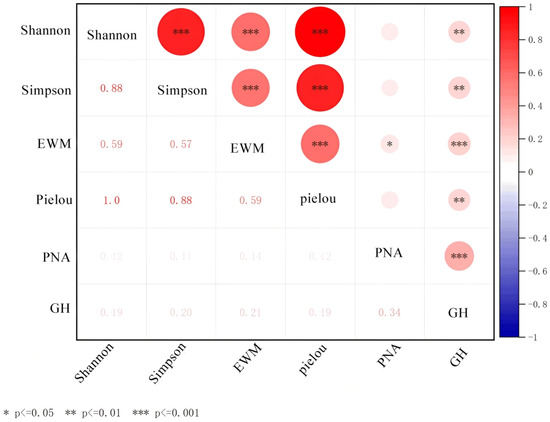
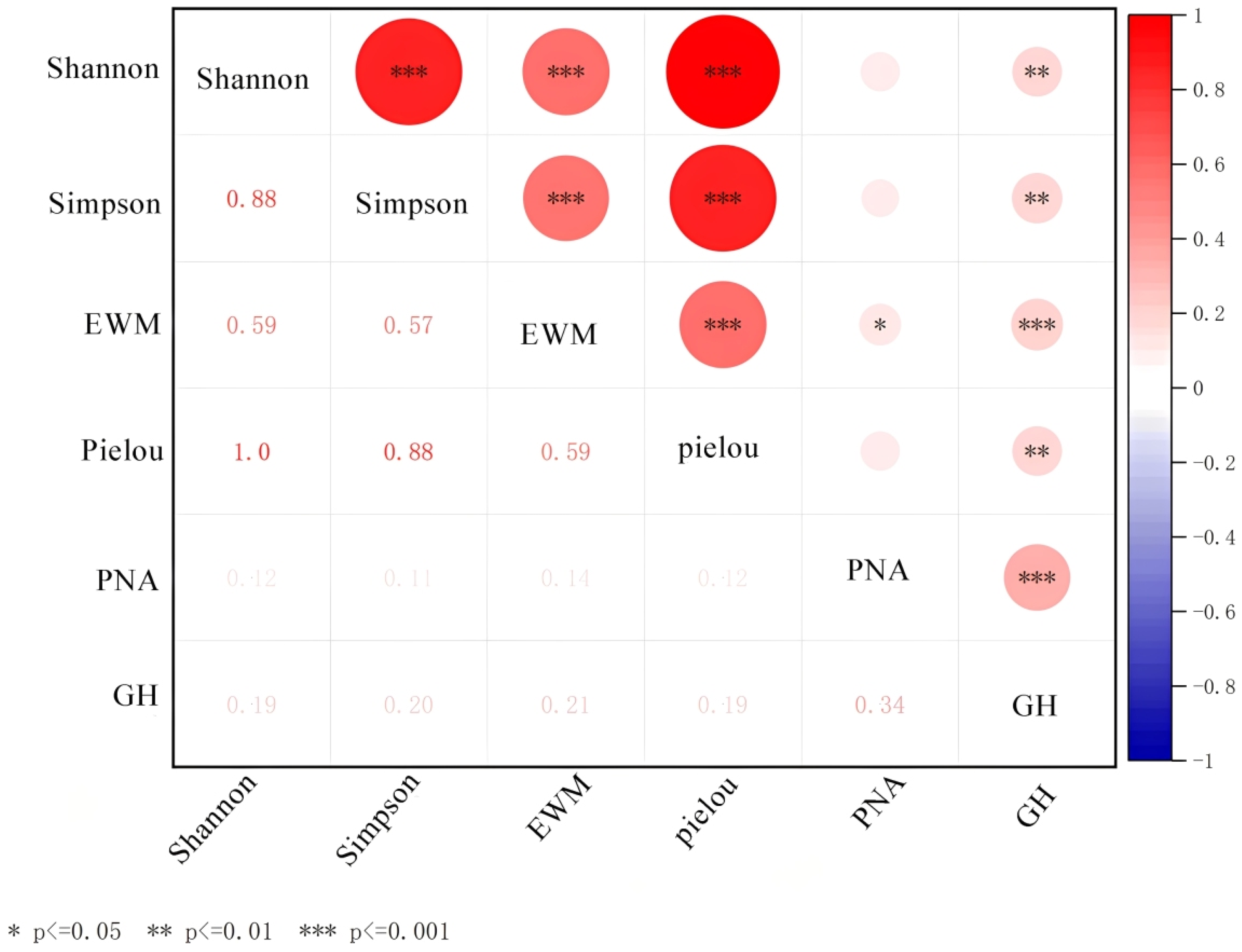
Correlation analysis was conducted between the results of the four evaluation methods and the distributions of the nature reserves and geoheritage sites. The Shannon, Simpson, EWM, and Pielou indices exhibited relatively high positive correlation coefficients. All four indices showed weak correlations with protected natural areas (PNA) and geological heritage (GH), which did not reach significant correlation level. However, their correlation coefficients with PNA and GH were all positive, indicating a weak, positive linear correlation trend (Figure 9).
Figure 9.
Correlation analysis of the four evaluation methods. Three stars (***) indicate an extremely strong correlation at a statistical significance level of p < 0.001; two stars (**) indicate a strong correlation at a statistical significance level of p < 0.01; one star (*) indicates a significant correlation at a statistical significance level of p < 0.05; no stars (no symbol) indicate no significant correlation at a statistical significance level of p > 0.05. The larger the red circle, the stronger the positive correlation.
4.2. Geoheritage Rating
In this study, the 65 geoheritages sites in Changzhi City were classified according to the scheme outlined in the Technical Requirements for the Compilation of National Geopark Planning (Ministry of Land and Natural Resources (2016) No. 83, revision No. 1 by the National Forestry and Grassland Administration of 2019) [55]. The sites were categorized into seven major categories, twelve subcategories, and sixteen tertiary categories.
The categories of all 65 geoheritages sites were determined through survey and assessment. Detailed field investigations were conducted in the study area according to the provisions of the Specification for Geoheritage Investigation (DZ/T0303-2017), and it was found that Changzhi City contains abundant, well-preserved, and highly protectable geoheritages. The overall weights of the evaluation indices, ranked from highest to lowest, are the esthetic value, scientific value, natural system integrity, typicality, socio-economic value, rarity, protectability, and degree of preservation (Table 4). The results indicate that Changzhi City contains four global-level, 18 national-level, 24 provincial-level, and 19 sub-provincial geoheritage sites (Table A3), accounting for 6.15%, 27.69%, 36.92%, and 29.23%, respectively.
Table 4.
Comprehensive weights of evaluation factors for geoheritage in Changzhi City.
Based on sensitivity analysis of the evaluation system for 65 geoheritage sites (Figure A1), in this study, we selected a comprehensive weighting ratio of 0.5, i.e., an equal contribution of subjective and objective weights, owing to its integrated advantages in terms of balance, stability, and rationality. First, this configuration achieves an effective balance between objective data patterns and subjective expert judgment. Second, analytical results confirm the strong stability of the evaluation system under this weighting: the fluctuation of the average composite score of the sites with change in the comprehensive weighting ratio is minimal (only 0.14%); the ranking correlation coefficients under different comprehensive weightings are close to 1; and 95.4% of the sites exhibit negligible changes in ranking. These findings indicate that the evaluation conclusions obtained using a comprehensive weighting of 0.5 are highly reliable. Finally, in terms of the indicator weight distribution, a comprehensive weighting of 0.5 assigns moderate weights to key indicators such as the esthetic value, preservation status, and protectability, thereby comprehensively reflecting both the value and conservation feasibility of the sites without introducing extreme bias. Therefore, a comprehensive weighting of 0.5 represents an optimized choice that integrates subjective and objective information, yields robust results, and ensures reasonable indicator weighting, providing a scientific and reliable basis for classification and management decision-making of geoheritage sites (Figure 10).
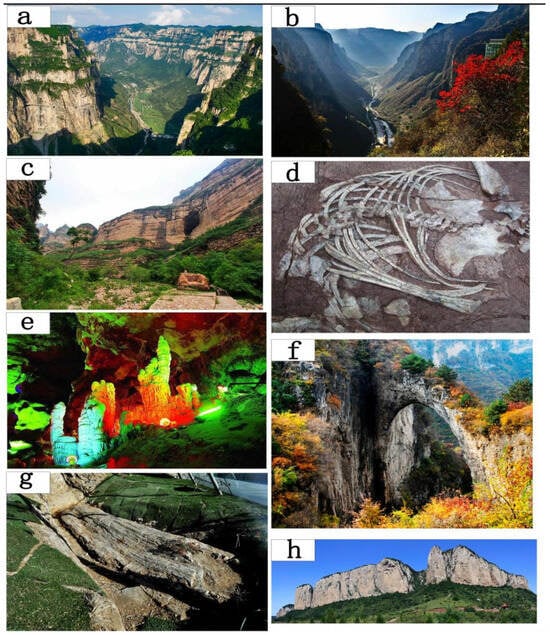
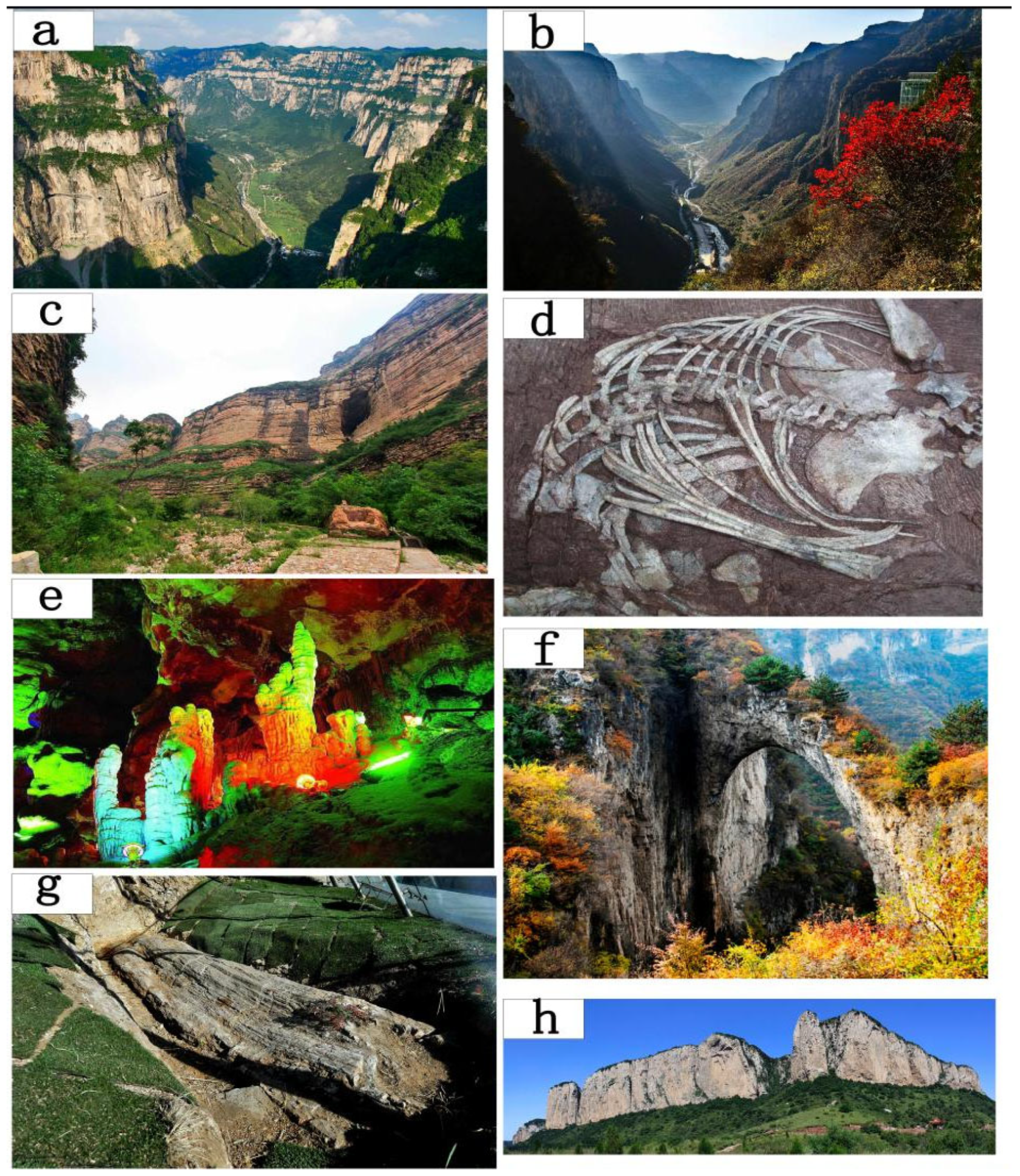
Figure 10.
Map of selected geological sites in Changzhi City. (a) Pingshun Tianji Mountain, Shenlongwan Tianpu Gorge; (b) HuGuan Shan’ao, open section at the starting point of Baquan Gorge; (c) Licheng Huangya Cave; (d) Sinokannemeyeria pischeri; (e) Wuxiang Taihang Dragon Cave; (f) HuGuan Ewu Natural Bridge; (g) Zhangzi Petrified Wood; (h) Wuxiang Zuhui Banshan Steep Cliff Long Wall.
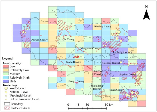
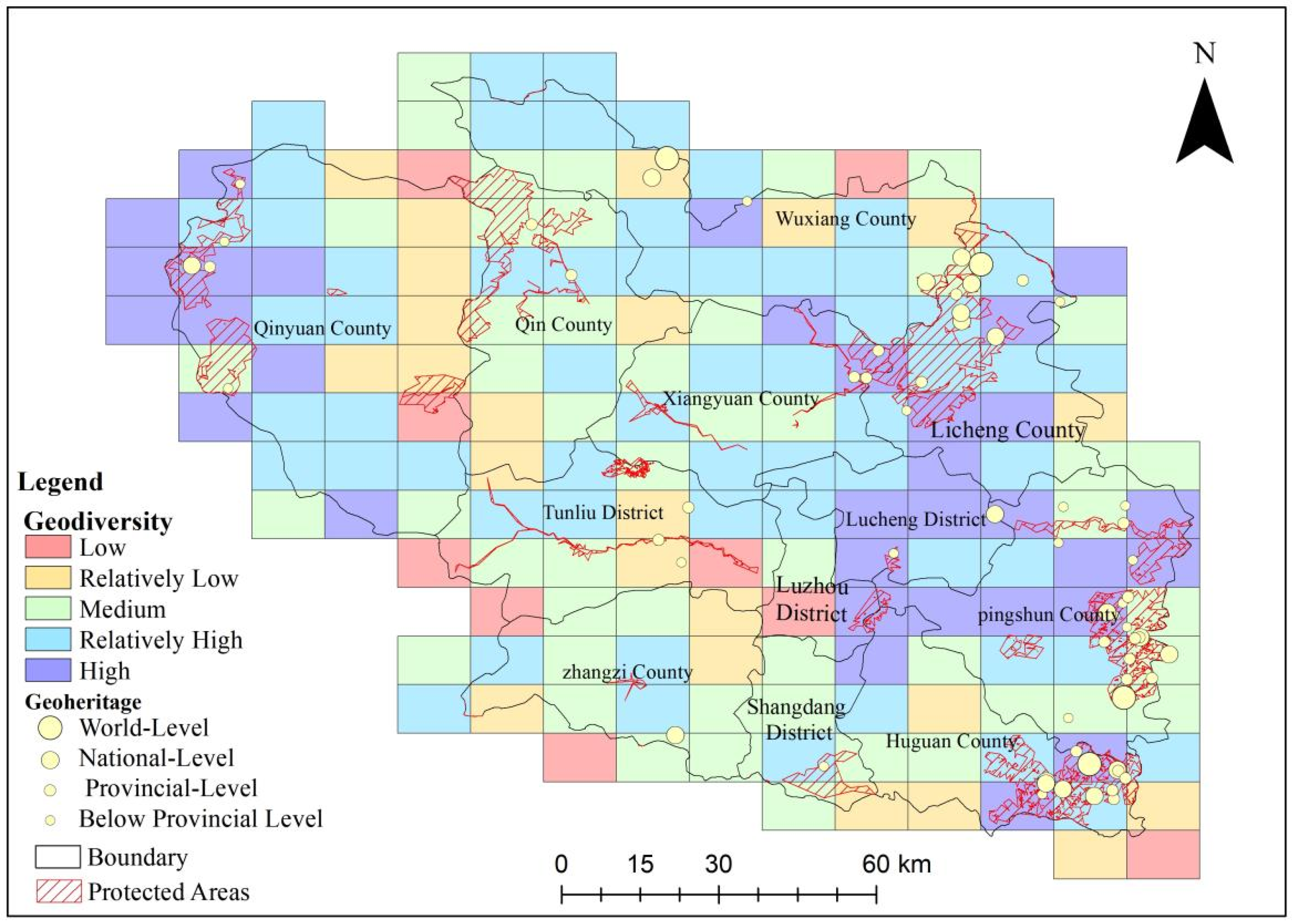
Figure 11 was obtained by combining the geoheritage and geodiversity evaluation results and nature reserves. The results suggest that the geodiversity of Changzhi City is higher in the east and west and lower in the central part. The geoheritage sites are mostly distributed in the east, and the nature reserves are generally distributed in areas with higher geodiversity.
Figure 11.
Comprehensive map of geodiversity evaluation in Changzhi City (entropy-weight method).
4.3. Construction Plan for Changzhi Global Geopark
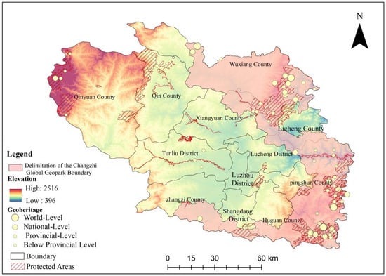
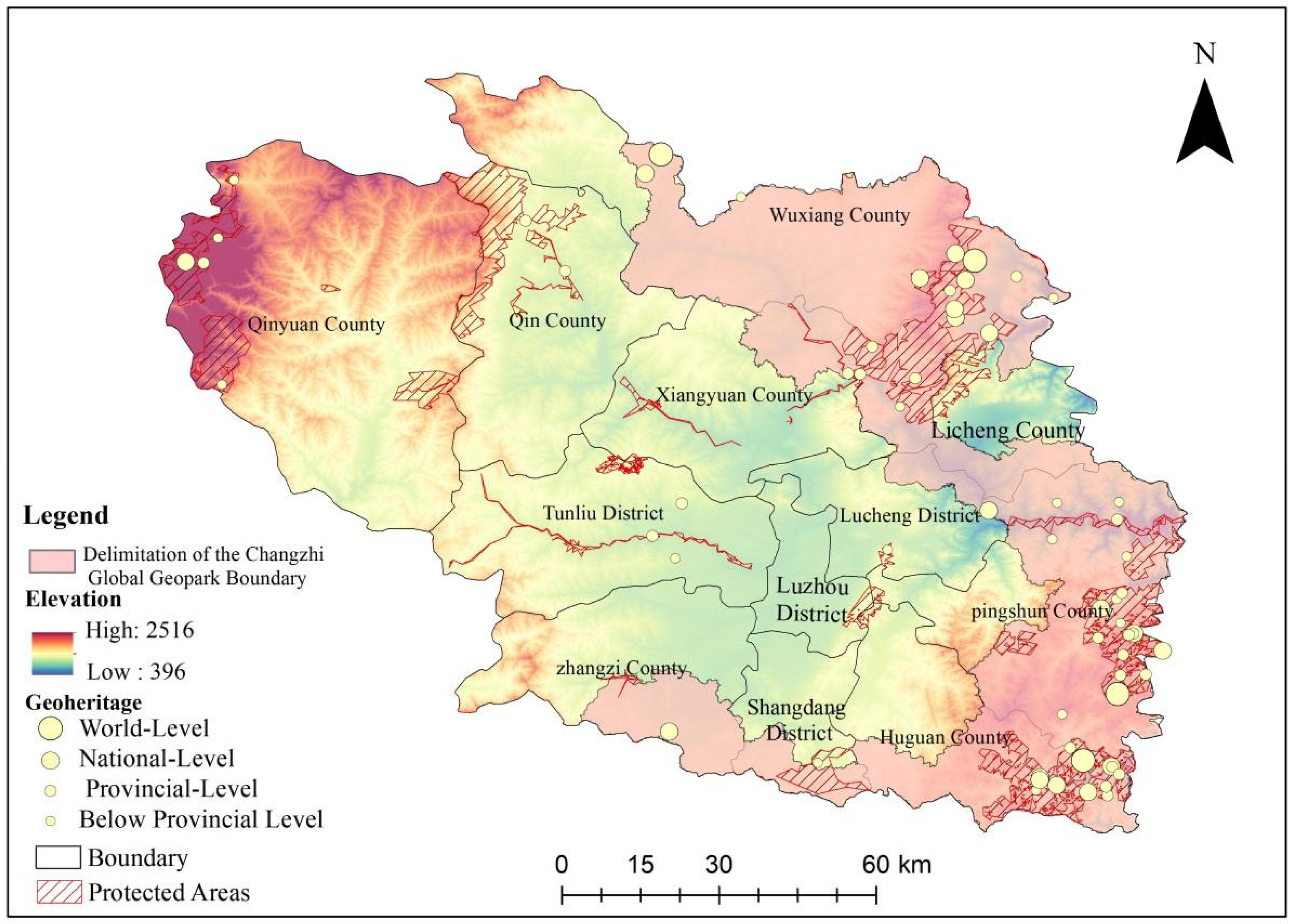
Based on geoheritage, geodiversity, and nature reserves, Changzhi City meets the basic requirements for establishing a UNESCO Global Geopark. Based on the application criteria and the results of this study, the preliminary boundaries of the Changzhi Global Geopark were delineated by following township, district, and county administrative lines, encompassing eight districts/counties and 38 townships, namely, Wuxiang County (Hongshui Town, Panlong Town, Fengzhou Town, Shibei Township, Jiahuo Township, Dayou Township, Shangsi Township, Jianzhang Town, and Hanbei Town), Licheng County (Shangyao Town, Xijing Town, Huangyadong Town, Hongjing Town, Xiwu Town, and Chengjiashan Town), Pingshun County (Beidanche Township, Yanggao Township, Shicheng Town, Hongtiguan Township, Dongsitou Township, Xigou Township, Longxi Town, and Yuxiaguan Town), Huguan County (Baichi Town, Shipo Township, Shuzhang Town, Dongjingling Township, Daxiagu Town), Shangdang District (Xihuo Town, Nansong Town, and Bayi Town), Changzi County (Nanchen Town, Datoubao Town, Cilin Town, and Setou Town), Xiangyuan County (Xiying Town and Xialiang Town), and Lucheng District (Xin’anquan Town), covering a total area of 4458.51 km2 (Table 5, Figure 12). The delineation primarily considers the geoheritage, the geodiversity, and the functions of the nature reserves and geoparks. Following the Technical Requirements for the Compilation of National Geopark Plans and the Specifications for Geoheritage Investigation, the 54 geoheritage sites within the proposed Changzhi Global Geopark (Table A4) were grouped into six major categories, 10 subcategories, and 13 tertiary categories, including geological profiles, paleontology, mineral and ore deposits, landforms, water bodies, and environmental geoheritage landscapes. The boundaries show substantial overlaps with existing plans for ecological protection and historical-cultural conservation. This alignment supports multi-plan integration and coordinated development, enabling resource sharing and synergistic planning. It contributes to ecological conservation, cultural relic protection, and tourism development, thereby promoting sustainable economic, social, and environmental development.
Table 5.
Changzhi World Geopark, Shanxi Province: Divisions List.
Figure 12.
Delineation scope of the Changzhi City World Geopark.
The two UNESCO Global Geoparks nearest to Changzhi City are the Yuntaishan Global Geopark (60 km away) and the Wangwushan–Daimeishan Global Geopark (142.5 km away). Within the proposed area, four global-level geological sites were identified, including Pingshun Shenlongwan Tianpu Gorge (a representative carbonate-rock canyon in the Taihang Mountains); Huguan Baquan Gorge (the most abundant and visually striking canyon in the entire Taihang carbonate-rock region); the Licheng Huangyadong Zhangshiyan landform (a typical example of the Zhangshiyan geomorphology in the Taihang Mountains and comparable to Grand Canyon in the United States); and the Wuxiang Sinokannemeyeria Fauna Fossil Site, which consists of three major regions: Wuxiang Shibi Zhangcungou, Wuxiang Shibi Longhuangou, and Wuxiang Louzeyu. These sites contain Parakannemeyeria dolichocephala (Sun, 1960), Sinokannemeyeria pearsoni, Parakannemeyeria youngi (Sun, 1963), and Shansiuchus shansiensis fossils. The diversity of the fossils provides key evidence for studies of biological evolution, geological age determination, and the interpretation of major evolutionary events.
5. Discussion
5.1. Geodiversity Evaluation
Regarding the evaluation of geodiversity, there is currently no standard method that is applicable across different regions. Petrović et al. [56] applied the method developed by Serrano et al. [57] to integrate various geological elements with topographic roughness and surface characteristics and calculated the geodiversity. Wang et al. [12] used the Shannon diversity index and Rao’s quadratic entropy to quantify the alpha geodiversity of the Lancang-Mekong River Basin. Because the suitability of the different evaluation methods may vary depending on the regional characteristics, we conducted a comparative analysis of the different methods of assessing the geodiversity in Changzhi City.
Among the Shannon diversity index, Simpson diversity index, EWM, and Pielou evenness index, only the Shannon diversity index was significantly different in the areas with and without geoheritage and in the areas with and without nature reserves. Under ecological radiation, none of the four methods exhibited significant differences. The Shannon diversity index meets the multi-dimensional quantitative needs of geological elements, taking into account both the richness and evenness of elements, capturing gradient differences, and maintaining rigorous logic. Compared with other evaluation methods, it exhibits higher sensitivity and better discrimination towards geological heritage elements, and can be used as a preferred method for accurately identifying the value of geological heritage and evaluating regional differences in geodiversity. Ecological radiation may mask true regional differences. After such interference is removed, the Shannon diversity index can effectively identify the impact of nature reserve construction on the geodiversity. Compared with the other methods, the EWM is more suitable for assessing geodiversity without the effects of ecological radiation and provides a scientific foundation for nature reserve planning and geological resource management.
Based on a systematic comparison of the four evaluation methods, it was found that the Shannon diversity index, with its objective weighting mechanism, has advantages in quantifying the complex characteristics of geodiversity and in accurately capturing regional differences. Its evaluation results are more reliable than those of the other three methods. Therefore, to ensure accuracy and objectivity, the Shannon diversity index was selected to conduct an evaluation of the geodiversity in Changzhi City, providing robust data support and a solid theoretical foundation for subsequent research on geological resource protection and development.
5.2. Relationship Between Geodiversity, Geoheritage, and Nature Reserves
Areas with a high geodiversity are more likely to generate and preserve abundant geoheritage sites. For example, three of the four global-level geoheritage sites in Changzhi City are located in the eastern region. However, in some areas with high geodiversity, geoheritage sites have not yet been found, which may be due to factors such as erosion, human disturbances, or survey biases. These findings are consistent with the results of Elkaichi et al. [8] on the M’Goun UNESCO Global Geopark and the results of Zakharovskyi et al. [58] on the geoheritage and geodiversity in Western Samoa. In general, areas with rich geodiversity have a significantly higher probability of developing geoheritage compared to areas with low geodiversity.
Changzhi City exhibits a pattern of higher geodiversity in the east and west and lower geodiversity in the central region, and the east exhibits the highest levels. The high-value areas in the west are primarily located along the boundaries with adjacent regions. The nature reserves are generally distributed in areas with medium to high geodiversity values. However, the Qinxian Nature Reserve has a low level of geodiversity, likely due to a relatively uniform geological background, limited rock and soil variations, and lack of structural and compositional diversity. This underscores the importance of scientific evaluation in developing integrated ecological–geological protection strategies. These findings align with those of previous studies, indicating that there is strong interdependence between nature reserves and geodiversity [59,60,61]. Therefore, nature reserves are mostly distributed in high geodiversity areas. geodiversity and nature reserves are interdependent; areas with a high geodiversity often contain unique ecosystems and biodiversity. Incorporating them into nature reserves helps maintain the ecological chain and protect geological landscapes.
5.3. Characteristics of Changzhi as a Global Geopark Candidate
5.3.1. Comparison of Canyon Landforms Around the World
The proposed Changzhi Global Geopark is a tectonic-geomorphological geopark located on the second major geomorphic step in the southeastern margin of the North China Mountains [62]. It has been influenced by the Cenozoic uplift of the Qinghai–Tibet Plateau, and the region has experienced six stages of uplift and subsidence [63,64,65,66], as well as multiple phases of tectonic uplift associated with neotectonic rift activity [67,68]. Driven by the combined effects of tectonic uplift and fluvial incision, the area has developed a canyon landscape characterized by high mountains, deep valleys, canyon groups, and peak clusters, demonstrating the positive feedback between tectonic processes and climatic responses. In comparison with the canyon landscapes of other UNESCO Global Geoparks such as the Yuntaishan and Wangwushan geoparks, the proposed geopark exhibits even more distinctive and rare geomorphological features. The canyons in the Yuntaishan Global Geopark were formed during the Neogene neotectonic movement, exposing the Paleoproterozoic Yunmengshan Formation and Paleozoic Cambrian-Ordovician strata [69]. The dark purple quartz sandstone deposited in the Paleoproterozoic [70] was shaped into the characteristic Yuntaishan landform during the Quaternary [71]. Wangwushan, located on the southern slope of the Taihang Mountains, showcases geological records spanning five periods and preserves evidence of four Precambrian orogenic events [72]. The canyons are primarily developed in the Mesozoic red sandstone and Paleoproterozoic metamorphic rocks. In contrast, the canyon slopes in Changzhi are mainly formed in the Cambrian-Ordovician carbonate rocks, and only the Qinglong Gorge in Huguan formed in Paleoproterozoic red sandstone. This lithological distinction reflects the unique geological evolutionary history of the area.
Enshi Grand Canyon-Tenglong Cave and the Xiangxi Global Geopark feature karst canyons, which developed in Cambrian strata during the Paleozoic and were formed through fluvial erosion, crustal uplift, and gravity-induced collapse [73]. The Taihang Mountain canyons in Changzhi similarly contain karst landscapes such as stone forests and caves, but they also contain long walls and peak clusters formed in Paleoproterozoic quartz sandstone as a result of differential weathering. In addition, a relatively complete Neoarchean to Quaternary stratigraphic sequence is exposed in this region, preserving a 2.5-billion-year record of the geological history of the North China Block. The canyons in southern Brazil formed approximately 180 million years ago during the breakup of the Gondwana supercontinent [74], while the Grand Canyon in Colorado, USA, was carved into Paleozoic–Mesozoic sandstone [75,76]. In contrast, the canyons in Changzhi expose a nearly continuous sedimentary sequence of the North China Plate and retain the metamorphic deformation records of the Zanhuang Rock Group, revealing key processes that occurred in the early continental core amalgamation stage of the North China Craton. The abundance, density, typicality, and the diversity of canyons and geomorphic features in this region are outstanding on a global scale.
5.3.2. International Comparison of the Sinokannemeyeria Fauna
The Sinokannemeyeria fauna fossils in Wuxiang County are of great scientific significance for understanding terrestrial tetrapod evolution, ancient plate movement and paleogeography, and the co-evolution of environments and organisms. Thousands of fossils have been unearthed, including 11 species across nine genera of archosaurs, therapsids, and amphibians, reflecting the radiation characteristics of early terrestrial vertebrates. The fossils of Shansius (the top predator) exhibit evidence of adaptations for terrestrial predation. Herbivorous animals such as Kannemeyeriidae possessed efficient digestive structures; Sinognathus occupied small to medium ecological niches; and labyrinthodont amphibians adapted to semi-aquatic habitats. This fauna record provides an important source of information for studying the morphology and phylogeny of dicynodonts and archosaurs [77].
The Sinokannemeyeria fauna, together with contemporaneous assemblages from South Africa, Russia, and South America, constitutes a global benchmark for studying the morphology, skeletal structure, and phylogeny of dicynodonts and archosaurs, and plays an irreplaceable role in the traditional tetrapod evolutionary framework. It also provides key geological evidence for reconstructing the paleogeography of Pangaea and determining ancient plate assemblages. Compared with the Early Triassic landscape in the Karoo Basin in South Africa, which was dominated by Lystrosaurus and lacked higher-ranking archosaurs, the Sinokannemeyeria fauna highlights the biogeographical isolation between Laurasia and Gondwana [78,79,80]. The Triassic Erythrosuchus in the Ural region in Russia exhibited morphological similarities to Shansisuchus in Wuxiang County, Shanxi Province, supporting the hypothesis of the occurrence of transcontinental diffusion prior to the breakup of Pangaea [81]. In terms of environment–organism co-evolution, the Xinjiang area may have served as a refuge for plants and animals during the Permian–Triassic mass extinction, and the ecological oases in this area preserved the continuous vegetation evolution and provided conditions for faunal recovery. By the Middle Triassic, the Shanxi region had undergone ecological restoration, leading to the development of Sinokannemeyeria fauna and establishing a complete ecosystem, which functioned as a migration corridor for therapsids [82,83]. As a signal of Triassic terrestrial ecological recovery following the end-Permian mass extinction, the Sinokannemeyeria fauna encapsulates the full process of environment–organism co-evolution from the Late Permian to the Middle Triassic and has become a frontier topic in contemporary Earth science.
5.3.3. International Comparison of the Zhangshiyan Landform
The name and preliminary definition of the Zhangshiyan landform were proposed by Guo Kang in a paper published in Acta Geographica Sinica in 1992 [84]. As one of the three major sandstone landforms in China, the Zhangshiyan landform holds potential for international recognition, although its geological typicality and academic influence remain in the early stages of dissemination. It is primarily distributed in the southern Taihang Mountains at the junction of Hebei, Henan, and Shanxi provinces, extending roughly 400 km along a fault zone and covering an area of about 3200 km2. The landform is named after the Zhangshiyan National Geopark in Zanhuang County, Hebei Province [84,85,86]. The landform exhibits a characteristic structure of three ancient corridors linking nine valleys, featuring stepped red cliff walls over 100 m high and more than 300 km long, Ω-shaped valleys (natural echo walls), blocky micro-landforms (mesa mountains and tower pillars), and complex canyon systems composed of box-shaped valleys and waterfalls [87,88]. Its main lithology is siliceous-cemented quartz sandstone of the Paleoproterozoic Changcheng System, with a thickness of 400–600 m. Controlled by the Taihang Mountains deep fault zone, it has undergone four evolutionary stages: sedimentary deposition (>200 Ma), tectonic uplift (5–25 Ma), valley incision (1–5 Ma), and gravity collapse (1 Ma–present), completing a 2.947 Ma geomorphic cycle [87,89]. Compared with the Danxia landform (Mesozoic red beds) and Zhangjiajie landform (Devonian quartz sandstone), the Zhangshiyan landform consists of older lithology and retains coastal sedimentary structures. Its red cliff domes and tower-peak forests, distinguished by extensive red cliff walls and Ω-shaped ridges [84,90,91], together with its hard sandstone-soft mudstone stratigraphic configuration and its coupled tectonic-climatic evolution, provide a unique case study for exploring global red-bed landform classification, heterogeneous rock-erosion mechanisms, and theories on landform evolutionary stages [92].
6. Conclusions
In this study, we took Changzhi City, Shanxi Province, as a case study and utilized geographic information systems and various ecological indices to quantitatively assess the regional geodiversity and explore synergistic conservation pathways between geoheritage sites and protected natural areas. The main conclusions of this study are summarized below.
(1) Our research confirms that the geodiversity in Changzhi exhibits significant spatial heterogeneity, presenting a pattern of high in the east and west and low in the central area. The geoheritage sites (65 in total) are highly concentrated in the eastern region, and the high-grade sites exhibit notable clustering. Notably, the areas with high geodiversity significantly overlap spatially with existing protected natural areas, providing a crucial natural basis for implementing integrated geo-ecological conservation.
(2) Moving beyond the simple application of a single evaluation method, in this study, we systematically compared the performances of the Shannon index, Simpson index, entropy weight method, and Pielou index within the local context. This provided the first empirical verification that the Shannon diversity index is most suitable for characterizing the complex geodiversity of Changzhi, offering a validated and reliable methodological option for subsequent research in this region. Furthermore, this study is the first systematic quantitative assessment of the geodiversity and geoheritage across the entire Changzhi area, effectively filling a research gap in this field. Based on the evaluation results, a preliminary potential boundary for a UNESCO Global Geopark was delineated, covering eight counties and 39 townships. This boundary proposal forms a comprehensive spatial plan that integrates core geoheritage values, the current ecological protection status, and the principle of multi-plan integration, providing direct technical and scientific support for future geopark nomination and conservation efforts.
(3) In this study, we constructed a comprehensive evaluation system. The inclusion of related biological elements (such as biodiversity) was primarily for the consideration of building a relatively comprehensive indicator system for geodiversity assessment. This represents a common methodological practice in current international quantitative assessments of geodiversity (evaluation frameworks such as alpha, beta, and gamma from biodiversity research have been introduced and applied in geodiversity evaluation). It aims to reflect the biological characterization layer that co-evolves with and is constrained by the geological environment. However, its treatment mainly remains at the level of description and indicator integration. It must be acknowledged that the intrinsic connections and interaction mechanisms between geodiversity and biodiversity (or broader ecosystem attributes) constitute an extremely complex and still-developing frontier scientific field. A great deal of work still needs to be conducted to advance geodiversity assessment towards deep integration with ecosystem processes. Our approach in this study more effectively reflects a common practice in current applied research aimed at enhancing the comprehensiveness of system description, yet it undoubtedly constitutes a limitation in the depth of our theoretical exploration. The primary contribution of this paper is that for the first time, it establishes a complete and operational set of geodiversity evaluation and decision-support systems for Changzhi City, encompassing method comparison and selection, current status assessment, and spatial integration.
Author Contributions
Y.L.: Research conception and design, overall project coordination, manuscript writing and revision, and final version approval. J.C.: Data collection and curation, field investigation, figure preparation, and initial draft writing. S.L.: Data analysis and processing, model construction, and result discussion and analysis. F.T., Z.D. and L.T.: Participation in field investigation, data collection and interpretation, and literature review. B.Y. and M.W.: Participation in comparative study of UNESCO Global Geopark criteria and text revision. T.J.: Data visualization, figure finalization, formatting, editing, and proofreading. Y.Z.: Provision of partial regional geological data and participation in data analysis and result discussion. All authors have read and agreed to the published version of the manuscript.
Funding
This research was funded by the Shanxi Province Basic Research Program General Project (Grant No. 20210302123378) and the 2023 Geopark Construction Project of the Forestry and Grassland Administration of Shanxi Province.
Institutional Review Board Statement
Not applicable.
Informed Consent Statement
Not applicable.
Data Availability Statement
The raw data supporting the conclusions of this article will be made available by the authors upon request.
Acknowledgments
We acknowledge the Shanxi Provincial Bureau of Forestry and Grassland and the Changzhi Municipal Bureau of Urban-Rural Planning and Natural Resources for providing data support.
Conflicts of Interest
The authors declare no conflicts of interest.
Appendix A
Table A1.
Scoring criteria for geoheritage.
Table A2.
List of important nature reserves in Changzhi City.
Table A3.
Changzhi City Geoheritage Rating.
Figure A1.
Weight Sensitivity Analysis.
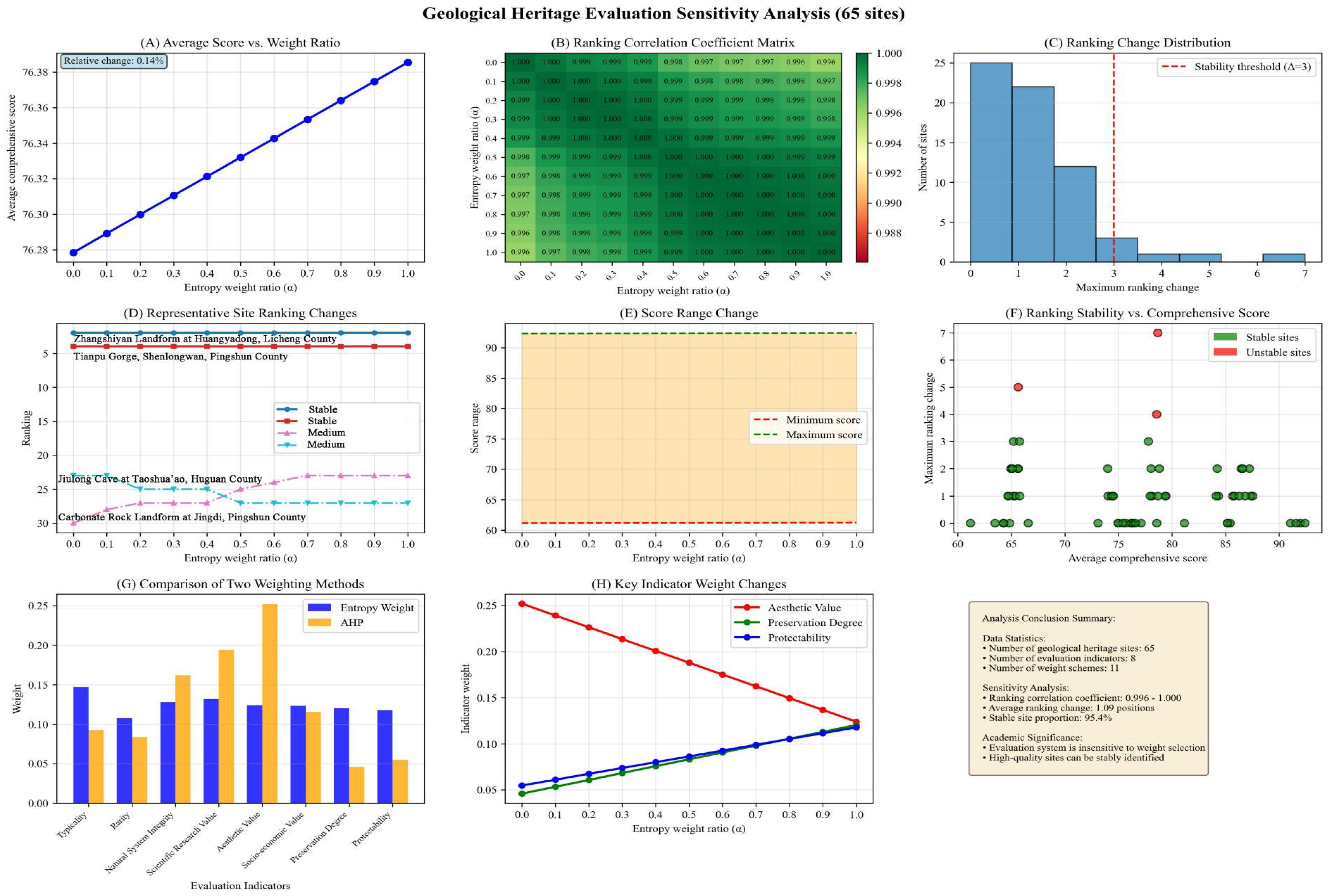
Table A4.
Classification of geoheritage in Changzhi Taihang Mountain Global Geopark.
References
- Hunter, M.L.; Jacobson, G.L.; Webb, T. Paleoecology and the coarse-filter approach to maintaining biological diversity. Conserv. Biol. 1988, 2, 375–385. [Google Scholar] [CrossRef] [Scilit]
- Wallis, C.I.B.; Tiede, Y.C.; Beck, E.; Böhning-Gaese, K.; Brandl, R.; Donoso, D.A.; Espinosa, C.I.; Fries, A.; Homeier, J.; Inclan, D.; et al. Biodiversity and ecosystem functions depend on environmental conditions and resources rather than the geodiversity of a tropical biodiversity hotspot. Sci. Rep. 2021, 11, 24530. [Google Scholar] [CrossRef] [Scilit] [PubMed]
- Somma, R.; Spoto, S.E.; Giacobbe, S. Geological and Structural Framework, Inventory, and Quantitative Assessment of Geodiversity: The Case Study of the Lake Faro and Lake Ganzirri Global Geosites (Italy). Geosciences 2024, 14, 236. [Google Scholar] [CrossRef] [Scilit]
- Carrión-Mero, P.; Dueñas-Tovar, J.; Jaya-Montalvo, M.; Berrezueta, E.; Jiménez-Orellana, N. Geodiversity assessment to regional scale: Ecuador as a case study. Environ. Sci. Policy 2022, 136, 167–186. [Google Scholar] [CrossRef] [Scilit]
- Vera, D.; Simbaña-Tasiguano, M.; Guzmán, O.; Cabascango, E.; Sánchez-Cortez, J.L.; Campos, C.; Grefa, H. Quantitative Assessment of Geodiversity in Ecuadorian Amazon—Case Study: Napo Sumaco Aspiring UNESCO Geopark. Geoheritage 2023, 15, 28. [Google Scholar] [CrossRef] [Scilit]
- Nieto, L.M.; Fernández, T.; Leiva-Lozano, J.E. Assessment of Geodiversity at the Confluence of Different Geological Domains and Delimitation of Natural Protected Areas (Examples from Southern Spain). Geoheritage 2023, 15, 92. [Google Scholar] [CrossRef] [Scilit]
- Rong, T.; Xu, S.; Lu, Y.; Tong, Y.; Yang, Z. Quantitative assessment of spatial pattern of geodiversity in the Tibetan Plateau. Sustainability 2022, 15, 299. [Google Scholar] [CrossRef] [Scilit]
- Elkaichi, A.; Errami, E.; Patel, N. Quantitative assessment of the geodiversity of M’Goun UNESCO Geopark, Central High Atlas (Morocco). Arab. J. Geosci. 2021, 14, 2829. [Google Scholar] [CrossRef] [Scilit]
- Ferrando, A.; Faccini, F.; Paliaga, G.; Coratza, P. A Quantitative GIS and AHP Based Analysis for Geodiversity Assessment and Mapping. Sustainability 2021, 13, 10376. [Google Scholar] [CrossRef] [Scilit]
- Najwert, A.; Jankowski, P.; Niesterowicz, J.; Zwoliński, Z. Geodiversity assessment with global and local spatial multicriteria analysis. Int. J. Appl. Earth Obs. Geoinf. 2022, 107, 102665. [Google Scholar]
- Tukiainen, H.; Maliniemi, T.; Alahuhta, J.; Hjort, J.; Lindholm, M.; Salminen, H.; Snåre, H.; Toivanen, M.; Vilmi, A.; Heino, J. Quantifying alpha, beta and gamma geodiversity. Prog. Phys. Geogr. Earth Environ. 2023, 47, 140–151. [Google Scholar] [CrossRef] [Scilit]
- Wang, J.; Tao, J.; Heino, J.; Huang, M.; Ding, C. Geodiversity as a surrogate to inform freshwater fish diversity conservation and management. J. Appl. Ecol. 2025, 62, 1364–1377. [Google Scholar] [CrossRef] [Scilit]
- Li, M.; Jiang, J. On the Geoheritages in China and Their Protection. Geol. China 2000, 31–34. [Google Scholar]
- Zhao, T.; Zhao, X. Geoheritage Taxonomy and Its Application. Acta Geosci. Sin. 2009, 30, 309–324. [Google Scholar]
- Lü, Y.; Zhang, M.; Sun, P.; Leng, Y.; Dong, Y.; Liu, X.; Ji, Z.; Liang, C. Characteristics of Geoheritage and the Construction of a Proposed Global Geopark in Yan’an. Northwest. Geol. 2019, 52, 27–36. [Google Scholar]
- Ye, F.; Long, X.; Yu, W.; Zhang, R.; Pan, W.; Ren, H.; Lu, Y.; Zhao, S.; Yao, X. A Multidimensional Classification System for Geoheritage and Its Application. China Min. Mag. 2023, 32, 58–64. [Google Scholar]
- Yu, Y.; Wu, F.; Wang, Y.; Chu, H.; Han, J. Classification and Protection of Geoheritages in Dunhuang Geopark of China for the Sustainable Development. China Popul. Resour. Environ. 2016, 26, 300–303. [Google Scholar]
- Chu, H.; Wu, F.; Han, J. Characteristics and Quantitative Evaluation of Geoheritage Resources in Yimengshan Geopark. Sci. Technol. Manag. Land Resour. 2017, 34, 100–106. [Google Scholar]
- Wang, L.; Tian, M.; Zhang, J.; Wu, F.; Cheng, J. Evaluation of Geoheritage Resources and Comprehensive Utilization Value of the Hong Kong UNESCO Global Geopark in China. Geoscience 2024, 38, 520–532. [Google Scholar]
- Somma, R.; Gatì, I.A.; Giacobbe, S. Inventory and Quantitative Assessment of Coastal Geoheritage: Contribution to the Proposal of an Active Geomorphosite. Geosciences 2025, 15, 125. [Google Scholar] [CrossRef] [Scilit]
- Possenelli, M.; Gauci, R.; Devoto, S.; Selmi, L.; Coratza, P.; Vandelli, V. Inventory and Quantitative Assessment of Geosites in the Southern Sector of the Island of Malta. Geosciences 2024, 14, 292. [Google Scholar] [CrossRef] [Scilit]
- Jia, Z.; Wu, F.; Qiang, X.; Cai, Y. Geoheritage classification and assessment in Longyan aspiring Geopark (China). Geoheritage 2022, 14, 20. [Google Scholar] [CrossRef] [Scilit]
- Xie, T.; Gan, Y.; Zhang, Q.; Hu, S.; Zhou, C.; Huang, J.; Wen, W.; Yang, W.; Zhu, G. Characteristics and comprehensive evaluation of geoheritages in the Luoping Biota National Geopark. Geol. China 2013, 40, 1959–1967. [Google Scholar]
- Prosser, C.D. Our rich and varied geoconservation portfolio: The foundation for the future. Proc. Geol. Assoc. 2013, 124, 568–580. [Google Scholar] [CrossRef] [Scilit]
- Brilha, J. Inventory and Quantitative Assessment of Geosites and Geodiversity Sites: A Review. Geoheritage 2016, 8, 119–134. [Google Scholar] [CrossRef] [Scilit]
- Ruban, D.A. Geodiversity as a precious national resource: A note on the role of geoparks. Resour. Policy 2017, 53, 103–108. [Google Scholar] [CrossRef] [Scilit]
- Peng, Y.; Wu, C. The Coordination Between Geoheritage Resources and Their Protection and Utilization: A Case Study of Shaanxi Province. Resour. Sci. 2004, 26, 69–75. [Google Scholar]
- Chen, A. National Geopark Planning: The Key to Building and Managing Geoparks Well. Geol. Bull. China 2010, 29, 1253–1258. [Google Scholar]
- Yao, W.; Chen, J. Regional Synergistic Development of National Geoparks Based on Spatial Heterogeneity. Resour. Ind. 2011, 13, 93–98. [Google Scholar]
- Wang, L.; Zhu, Q. Characteristics of Geoheritages and Their Geological Significance in the Arxan Global Geopark of Inner Mongolia. Geoscience 2023, 37, 1075–1088. [Google Scholar]
- Local Chronicles Compilation Committee of Changzhi City. Changzhi City Annals; Haichao Press: Beijing, China, 1995; pp. 8–44. [Google Scholar]
- Xiong, J. Study on the Geo-diversity Assessment System: A Case Study of Dabie Mountain Area in Hubei Province. J. Anhui Agric. Sci. 2010, 38, 16466–16469. [Google Scholar]
- Zha, F.; Guo, W.; Zhang, J.; Yang, W.; Zhang, D.; Wei, M. Geoheritage Resources and Value Evaluation of the Qinling Zhongnanshan UNESCO Global Geopark. J. Arid Land Resour. Environ. 2016, 30, 182–187. [Google Scholar]
- Zhou, K.; Xu, T.; Xue, H. Value Evaluation of the Main Geoheritage Resources in the Fangshan UNESCO Global Geopark of China. China Popul. Resour. Environ. 2016, 26, 312–315. [Google Scholar]
- Forte, J.P.; Brilha, J.; Pereira, D.I.; Nolasco, M. Kernel Density Applied to the Quantitative Assessment of Geodiversity. Geoheritage 2018, 10, 205–217. [Google Scholar] [CrossRef] [Scilit]
- Da Silva, M.L.N.; do Nascimento, M.A.L.; Mansur, K.L. Quantitative Assessments of Geodiversity in the Area of the Seridó Geopark Project, Northeast Brazil: Grid and Centroid Analysis. Geoheritage 2019, 11, 1177–1186. [Google Scholar] [CrossRef] [Scilit]
- Pereira, D.I.; Pereira, P.; Brilha, J.; Santos, L. Geodiversity assessment of Paraná State (Brazil): An innovative approach. Environ. Manag. 2013, 52, 541–552. [Google Scholar] [CrossRef] [Scilit]
- Miros-Gómez, J.A. Geodiversidad Costera de Bahía San Quintín y Zonas Aledañas, Baja California, México. Master’s Thesis, Universidad Autónoma de Baja California, Mexico City, Mexico, 2017. [Google Scholar]
- Scammacca, O.; Bétard, F.; Aertgeerts, G.; Heuret, A.; Fermet-Quinet, N.; Montagne, D. Geodiversity Assessment of French Guiana: Challenges and Implications for Sustainable Land Planning. Geoheritage 2022, 14, 83. [Google Scholar] [CrossRef] [Scilit]
- Ahmadi, M.; Derafshi, K.; Mokhtari, D.; Khodadadi, M.; Najafi, E. Geodiversity Assessments and Geoconservation in the Northwest of Zagros Mountain Range, Iran: Grid and Fuzzy Method Analysis. Geoheritage 2022, 14, 132. [Google Scholar] [CrossRef] [Scilit]
- Dias, M.C.S.S.; Domingos, J.O.; Costa, S.S.d.S.; Nascimento, M.A.L.D.; da Silva, M.L.N.; Granjeiro, L.P.; Miranda, R.F.d.L. Geodiversity Index Map of Rio Grande do Norte State, Northeast Brazil: Cartography and Quantitative Assessment. Geoheritage 2021, 13, 10. [Google Scholar] [CrossRef] [Scilit]
- Miros-Gómez, J.A.; Canet, C.; Calmus, T. Geodiversity Assessment in the Midriff Islands Region of the Gulf of California (Northwest Mexico). Geoheritage 2024, 16, 51. [Google Scholar] [CrossRef] [Scilit]
- Bétard, F.; Peulvast, J.-P. Geodiversity hotspots: Concept, method and cartographic application for geoconservation purposes at a regional scale. Environ. Manag. 2019, 63, 822–834. [Google Scholar] [CrossRef] [Scilit] [PubMed]
- Menezes dos Santos, F.; de la Corte Bacci, D.; Saad, A.R.; da Silva Ferreira, A.T. Geodiversity index weighted by multivariate statistical analysis. Appl. Geomat. 2020, 12, 361–370. [Google Scholar] [CrossRef] [Scilit]
- Lopes, C.; Teixeira, Z.; Pereira, P. Addressing cell size selection in geodiversity quantitative assessment procedures. In Proceedings of the EGU General Assembly 2023, Vienna, Austria, 24–28 April 2023. EGU23-9821. [Google Scholar] [CrossRef] [Scilit]
- Barančoková, M.; Hutárová, D.; Nikolaj, M. Quantitative Assessment of Geodiversity for Conservation Purposes in Slovenské rudohorie Mountains (Slovakia). Land 2023, 12, 1650. [Google Scholar] [CrossRef] [Scilit]
- Yan, B. Characteristics and Evaluation of Geoheritage in the Southern Section of the Taihang Mountains, Shanxi Province. Ph.D. Thesis, China University of Geosciences (Beijing), Beijing, China, 2023. [Google Scholar] [CrossRef]
- Wu, H.; Wu, F. Classification and Evaluation of Geoheritage Resources in the Qian’an-Qianxi National Geopark of Hebei Province. Acta Geosci. Sin. 2011, 32, 632–640. [Google Scholar]
- Chen, B.; Zhang, C.; Yang, L.; Wang, W.; Wang, Y. Types and Evaluation of Geoheritage Resources in the Zigong UNESCO Global Geopark. Acta Geol. Sichuan 2023, 43, 162–170. [Google Scholar]
- Dong, Y.; Xue, L. Performance Evaluation Model and Algorithm of Green Supply Chain Management Based on ANP Theory. Soft Sci. 2008, 11, 56–63. [Google Scholar]
- Wang, Y. Constructing a Performance Evaluation Model for Applied Undergraduate University Teachers Based on Improved FAHP. Res. Acad. Issues 2017, 13, 72–76. [Google Scholar]
- GB/T 18972-2017; Classification, Investigation and Evaluation of Tourism Resources. National Technical Committee 210 on Tourism of Standardization Administration of China; Standards Press of China: Beijing, China, 2017. Available online: https://openstd.samr.gov.cn/bzgk/std/newGbInfo?hcno=B8AFA5B524438117E00F3BC259B6831C (accessed on 20 January 2026).
- DZ/T 0303-2017; Regulations for Geoheritage Investigation. Ministry of Land and Resources of the People’s Republic of China, China Standards Press: Beijing, China, 2017. Available online: https://std.samr.gov.cn/hb/search/stdHBDetailed?id=8B1827F25274BB19E05397BE0A0AB44A (accessed on 20 January 2026).
- Qu, X.; Gao, X.; Wang, M.; Luo, Y.; Li, J. Evaluation of Geoheritage Resources in the Qaidam Basin, China. J. Desert Res. 2022, 42, 167–174. [Google Scholar]
- Ministry of Land and Resources of the People‘s Republic of China. Technical Requirements for National Geopark Planning (Revised by Announcement No. 1 of the National Forestry and Grassland Administration, 2019) [Regulation]. Document No. [2016]83. 25 July 2016. Available online: https://www.sgnsgeopark.cn/file/sg2024060270022.pdf (accessed on 20 January 2026).
- Petrović, D.; Milinčić, M.; Vukoičić, D.; Ristić, D.; Milinčić, U.; Potić, I. Evaluation and valorization of geoheritage of the Mount Rogozna area. Carpathian J. Earth Environ. Sci. 2023, 18, 213–224. [Google Scholar] [CrossRef] [Scilit]
- Serrano, E.; Ruiz-Flaño, P. Geodiversity: A theoretical and applied concept. Geogr. Helv. 2007, 62, 140–147. [Google Scholar] [CrossRef] [Scilit]
- Zakharovskyi, V.; Németh, K. Scale influence on qualitative–quantitative geodiversity assessments for the geosite recognition of Western Samoa. Geographies 2022, 2, 476–490. [Google Scholar] [CrossRef] [Scilit]
- Alahuhta, J.; Tukiainen, H.; Toivanen, M.; Ala-Hulkko, T.; Farrahi, V.; Hjort, J.; Ikäheimo, T.M.; Lankila, T.; Maliniemi, T.; Puhakka, S.; et al. Acknowledging geodiversity in safeguarding biodiversity and human health. Lancet Planet. Health 2022, 6, e987–e992. [Google Scholar] [CrossRef] [Scilit]
- Yu, Y.; Yang, J. Advances in the Study of the Impact of Geodiversity on Biodiversity. Adv. Earth Sci. 2024, 39, 347–356. [Google Scholar]
- Maliniemi, T.; Tukiainen, H.; Hjort, J.; Toivanen, M.; Vernham, G.; Bailey, J.J.; Baines, O.; Benniston, L.; Brilha, J.; Field, R.; et al. Too much diversity—Multiple definitions of geodiversity hinder its potential in biodiversity research. Divers. Distrib. 2024, 30, e13843. [Google Scholar] [CrossRef] [Scilit]
- Li, X.; Fang, X.; Wu, F.; Miao, Y. Pollen evidence from Baode of the northern Loess Plateau of China and strong East Asian summer monsoons during the Early Pliocene. Chin. Sci. Bull. 2011, 56, 64–69. [Google Scholar] [CrossRef] [Scilit]
- Gong, M.; Ma, Y.; Huang, J.; Xu, J. Study on the Mountain Formation Process of the Southern Taihang Mountains in the Cenozoic. J. Shanxi Datong Univ. (Nat. Sci. Ed.) 2024, 40, 114–120. [Google Scholar]
- Shi, W.; Dong, S.W.; Hu, J.M. Neotectonics around the Ordos Block, North China: A review and new insights. Earth-Sci. Rev. 2020, 200, 102969. [Google Scholar] [CrossRef] [Scilit]
- Yu, J.; Zheng, D.; Pang, J.; Li, C.; Wang, Y.; Wang, Y.; Hao, Y.; Zhang, P. Cenozoic mountain building in eastern China and its correlation with reorganization of the Asian climate regime. Geology 2022, 50, 859–863. [Google Scholar] [CrossRef] [Scilit]
- Liu, Y.-S.; Utescher, T.; Zhou, Z.; Sun, B. The evolution of Miocene climates in North China: Preliminary results of quantitative reconstructions from plant fossil records. Palaeogeogr. Palaeoclimatol. Palaeoecol. 2011, 304, 1080–1090. [Google Scholar] [CrossRef] [Scilit]
- Ma, Y.; Zhao, X.; Zhao, X.; Wu, Z.; Gao, L.; Zhang, Y.; Zhao, T.; Wu, Z.; Yang, S. The Uplift and Rifting Processes of the Southern Margin of the Taihang Mountains in the Cenozoic. Acta Geosci. Sin. 2007, 28, 219–233. [Google Scholar]
- Cao, X.; Li, S.; Xu, L.; Guo, L.; Liu, L.; Zhao, S.; Liu, X.; Dai, L. Mesozoic-Cenozoic evolution and mechanism of tectonic geomorphology in the central North China Block: Constraint from apatite fission track thermochronology. J. Asian Earth Sci. 2016, 114, 41–53. [Google Scholar] [CrossRef] [Scilit]
- Zhao, X. Research on the Main Geological Setting of Yuntai Mountain: Genesis of Yuntai Landform; Geological Publishing House: Beijing, China, 2005. [Google Scholar]
- Zheng, D.; Zheng, W.; Wang, J.; Wu, L.; Ren, Z.; Su, Z.; Meng, F.; Wang, Y.; Yan, J. Characteristics of Red Sandstone of the Mesoproterozoic Yunmengshan Formation in Yuntai Mountain and Its Environmental Significance. J. Henan Polytech. Univ. (Nat. Sci.) 2011, 30, 534–538. [Google Scholar]
- Wang, F.; Zhang, Z. Characteristics of Neotectonic Movement in the Yuntai Shan Global Geopark of China. Geol. Chem. Miner. 2005, 27, 15–20. [Google Scholar]
- Zhang, M.; Zhang, M.; Li, J.; Sun, Y. Discussion on the Genetic Mechanism of Geological Structure and Scientific Value of Landscape in the Wangwushan Global Geopark. J. Henan Polytech. Univ. (Nat. Sci.) 2009, 28, 732–736. [Google Scholar]
- Jiang, Z.; Zhang, J.; Huang, C.; Rong, Y.; Wu, L. Genesis and Geological Significance of Karst Canyon Group in Xiangxi Geopark. Carsologica Sin. 2019, 38, 269–275. [Google Scholar]
- Valdati, J.; Bechtel, A.P.; Gomes, M.C.V.; dos Santos, Y.R.F.; Ricetti, J.H.Z.; Weinschütz, L.C. More than fossils: Paleoburrows as geoheritage and paleoenvironmental archives in the Caminhos dos Canions do Sul UNESCO Global Geopark, Southern Brazil. J. S. Am. Earth Sci. 2024, 149, 105205. [Google Scholar] [CrossRef] [Scilit]
- Polyak, V.; Hill, C.; Asmerom, Y. Age and evolution of the Grand Canyon revealed by U-Pb dating of water table-type speleothems. Science 2008, 319, 1377–1380. [Google Scholar] [CrossRef] [Scilit]
- Karlstrom, K.E.; Lee, J.P.; Kelley, S.A.; Crow, R.S.; Crossey, L.J.; Young, R.A.; Lazear, G.; Beard, L.S.; Ricketts, J.W.; Fox, M.; et al. Formation of the Grand Canyon 5 to 6 million years ago through integration of older palaeocanyons. Nat. Geosci. 2014, 7, 239–244. [Google Scholar] [CrossRef] [Scilit]
- Liu, J.; Sullivan, C. New discoveries from the Sinokannemeyeria-Shansisuchus Assemblage Zone: 3. Archosauriformes from Linxian, Shanxi, China. Vertebr. Palasiat. 2017, 55, 110–128. [Google Scholar]
- Chen, J.Y.; Liu, J. Journey to the east: The oldest tetrapod fauna of east Pangea in early Permian. Natl. Sci. Rev. 2024, 11, nwae249. [Google Scholar] [CrossRef] [Scilit]
- Liu, J.; Li, J.L. A New Material of Kannemeyerid from Xinjiang and the Restudy of Parakann Emeyeria Brevirostris. Vertebr. Palasiat. 2003, 41, 147–156. [Google Scholar]
- Rubidge, B.S.; Erwin, D.H.; Ramezani, J.; Bowring, S.A.; de Klerk, W.J. High-precision temporal calibration of Late Permian vertebrate biostratigraphy: U-Pb zircon constraints from the Karoo Supergroup, South Africa. Geology 2013, 41, 363–366. [Google Scholar] [CrossRef] [Scilit]
- Gower, D.J.; Sennikov, A.G. Morphology and phylogenetic informativeness of early archosaur braincases. Palaeontology 1996, 39, 883–906. [Google Scholar]
- Peng, H.P.; Yang, W.; Wan, M.L.; Liu, J.; Liu, F. Refugium amidst ruins: Unearthing the lost flora that escaped the end-Permian mass extinction. Sci. Adv. 2025, 11, eads5614. [Google Scholar] [CrossRef] [Scilit]
- Liu, J. A New Species of Parakannemeyeria (Therapsida, Dicynodontia) from the Kelamayi Formation of Jimsar, Xinjiang. Vertebr. Palasiat. 2004, 42, 77–80. [Google Scholar]
- Guo, K. The Discovery of the Zhangshiyan Landform and Its Value for Tourism Development. Acta Geogr. Sin. 1992, 47, 459–467. [Google Scholar]
- Li, J.; Wang, A.; Chen, Z. Cenozoic tectonic uplift and geomorphic response of the Taihang Mountains. Geogr. Res. 2015, 34, 501–512. [Google Scholar]
- Wang, A.; Li, J.; Liu, R. Petrological characteristics and geomorphological significance of the Zhangshiyan landform. Acta Petrol. Sin. 2018, 34, 2317–2328. [Google Scholar]
- Guo, K.; Zhang, Y.; Hu, Y. A Study on the Types and Formation Mechanism of Zhangshiyan Landform. Geogr. Res. 2008, 27, 1321–1331. [Google Scholar]
- Wang, H.; Li, J.H.; Wu, T.W. Characteristics and Genetic Analysis of Geoheritage in the Taihang Mountains. J. Sci. Nat. Sci. 2018, 54, 546–554. [Google Scholar]
- Chen, L.; Xu, Q.; Zhao, Y.; Li, Q.; Zhang, J. Evolution Characteristics and Geomorphologic Age of Zhangshiyan Landform. Sci. Geogr. Sin. 2011, 31, 964–968. [Google Scholar]
- Peng, H. Progress in the Research on Danxia Landform in China. Sci. Geogr. Sin. 2003, 23, 365–372. [Google Scholar]
- Chen, C.; Li, T.; Wang, N. Characteristics and Evolution of the Zhangjiajie Landform. Geogr. Res. 2005, 24, 517–525. [Google Scholar]
- Young, R.W.; Wray, R.A.L.; Young, A.R.M. Sandstone Landforms; Cambridge University Press: Cambridge, UK, 2009. [Google Scholar]

Disclaimer/Publisher’s Note: The statements, opinions and data contained in all publications are solely those of the individual author(s) and contributor(s) and not of MDPI and/or the editor(s). MDPI and/or the editor(s) disclaim responsibility for any injury to people or property resulting from any ideas, methods, instructions or products referred to in the content. |
© 2026 by the authors. Licensee MDPI, Basel, Switzerland. This article is an open access article distributed under the terms and conditions of the Creative Commons Attribution (CC BY) license.