


Abstract
Dam regulation alters riverine hydraulic conditions, potentially limiting fish spawning habitat. This study evaluated how discharge allocation could improve hydraulic suitability for Chinese sturgeon (Acipenser sinensis) spawning downstream of Gezhouba Dam. A three-dimensional hydrodynamic model, evaluated against historical near-bed velocities under approximate boundary conditions, simulated nine steady-state scenarios combining total discharges of 7090, 10,500, and 15,100 m3/s with Dajiang-to-Erjiang flow allocation ratios of 3:2, approximately 2:1, and 4:1. Hydraulically suitable areas were quantified using near-bed velocity and water-depth thresholds, and operational feasibility was discussed. Total discharge primarily controlled overall near-bed velocities, whereas flow allocation altered local velocity distributions. Integrated hydraulically suitable areas were largest under an approximately 2:1 allocation at low discharge and 4:1 at medium and high discharges, exceeding those under conventional 3:2 allocation by 34.1%, 23.5%, and 8.4%, respectively. These scenarios generally remained relatively favorable under joint threshold perturbations. Historical mean water-temperature records indicate a shift in the estimated thermal suitability window toward November–December. In a warming climate, these results identify candidate allocations for ecological operation within thermal suitability windows, subject to engineering constraints. Together with the 2025 side-channel spawning observations, they could inform small-scale spawning trials under controlled hydraulic conditions to complement mainstem regulation amid engineering disturbances.
1. Introduction
Sustainable reservoir operation requires integrating freshwater biodiversity conservation with hydropower generation, flood control, navigation, and water supply. Dam construction and reservoir operation alter river connectivity, flow regimes, thermal conditions, and habitat structure, affecting the environmental conditions required for fish reproduction [1]. Ecological operation can help mitigate these effects by adjusting reservoir releases during critical reproductive periods [2,3]. Where extensive channel modification is impractical, adjustments to existing operating practices may offer opportunities to improve hydraulic conditions. Their ecological effectiveness depends on matching the timing and form of regulation to the reproductive requirements of the target species.
Ecological operation has expanded in China since the early 2000s [2]. For fishes producing drifting eggs, these operations aim to create suitable spawning conditions by shaping the rising and falling phases of river flow [3,4]. At the Three Gorges Dam (TGD), ecological operation experiments targeting the four major Chinese carps (FMCC) began in 2011. By 2025, 24 experiments had been conducted over 15 consecutive years [5]. Observations from other regulated rivers also document reproductive responses during ecological operation. In the lower Jinsha River, egg density during the 2017 ecological operation of the Xiluodu–Xiangjiaba cascade was 30% higher than the pre-operation level [6]. In the middle and lower Hanjiang River, monitoring during four coordinated ecological operation trials between 2018 and 2024 yielded an estimated combined egg flux of approximately 2.17 billion eggs [7]. These observations illustrate the potential of flow regulation to support fish reproduction, although responses vary among operations and environmental conditions.
For fishes producing adhesive demersal eggs, ecological operation has placed greater emphasis on maintaining suitable water depths and limiting water-level fluctuations during spawning and incubation [8,9]. Such strategies seek to reduce egg exposure and disturbance while maintaining appropriate hydraulic conditions. International studies further show that the effectiveness of ecological operation depends on local environmental conditions and that its implementation may require balancing conservation goals with other reservoir management objectives [10,11]. In Australian floodplain wetlands, fish recruitment and abundance following environmental watering were associated with the water source, delivery method, and timing [12]. Other studies highlight interactions between flow and temperature and show that experimental flow pulses do not always produce detectable population responses [13,14]. A study of a United States reservoir also documented fishery disruption associated with reoperation for downstream environmental flows [15]. Together, these findings emphasize the need to assess both the ecological suitability and operational implications of proposed flow regulation.
Chinese sturgeon (Acipenser sinensis), a critically endangered anadromous fish of the Yangtze River, presents a particular conservation challenge [16,17,18]. Closure of Gezhouba Dam (GZB) in 1981 blocked access to its historical upstream spawning grounds, leaving a restricted spawning reach downstream of the dam [19,20,21]. No natural spawning by the wild population was detected from 2017 to 2025 [22]. In late 2025, Chinese sturgeon spawning was recorded during a controlled field experiment in the Yanzhiba side channel downstream of GZB, where open-channel diversion had modified both hydraulic and thermal conditions [22]. This experiment provides evidence that Chinese sturgeon can spawn under controlled field conditions and supports further investigation of hydraulic regulation under suitable thermal conditions.
Previous studies have examined changes in spawning-ground ecohydraulic suitability [23] and the relationship between flow velocity and Chinese sturgeon contact behavior [24]. Generating-unit operating patterns at GZB affect local velocity fields and the extent of areas with suitable flow velocities for Chinese sturgeon [25]. The Dajiang (DJ) and Erjiang (EJ) hydropower plants discharge into channels with different geometries. At a given total discharge, changing the DJ flow allocation ratio could modify local hydraulic conditions without increasing total release. However, Chinese sturgeon reproduction also depends on water temperature, substrate conditions, and broodstock maturity and behavior [20,26,27]. Both reservoir operation and atmospheric warming influence the thermal regime of the Yangtze River, with implications for the timing of suitable reproductive temperatures [28,29]. The present assessment is limited to hydraulic suitability, with suitable water temperature treated as an external prerequisite for ecological operation. Within this scope, further assessment is needed to quantify how DJ flow allocation affects near-bed velocity, water depth, and integrated hydraulically suitable area across different total discharges. This includes determining whether relatively favorable allocation ratios vary with total discharge and how operational constraints affect their applicability.
To address these questions, a three-dimensional hydrodynamic model was developed for the reach from GZB to Yichang Hydrological Station. Nine steady-state scenarios combined three representative total discharges with three DJ flow allocation ratios. Scenario comparisons were based on integrated hydraulically suitable area, and joint threshold perturbations were used to examine the sensitivity of area estimates and scenario rankings. Candidate allocations were screened against assumed post-refurbishment plant discharge capacities and selected navigation-related water-level requirements. These comparisons provide preliminary support for incorporating spawning-related hydraulic requirements into sustainable reservoir operation. The reliability and operational applicability of the candidate allocations require further evaluation. Implementation would depend on suitable water temperatures, available discharge, verified unit availability and discharge capacities, and compliance with other operating requirements.
2. Materials and Methods
2.1. Study Area
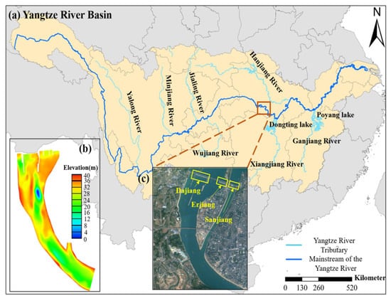
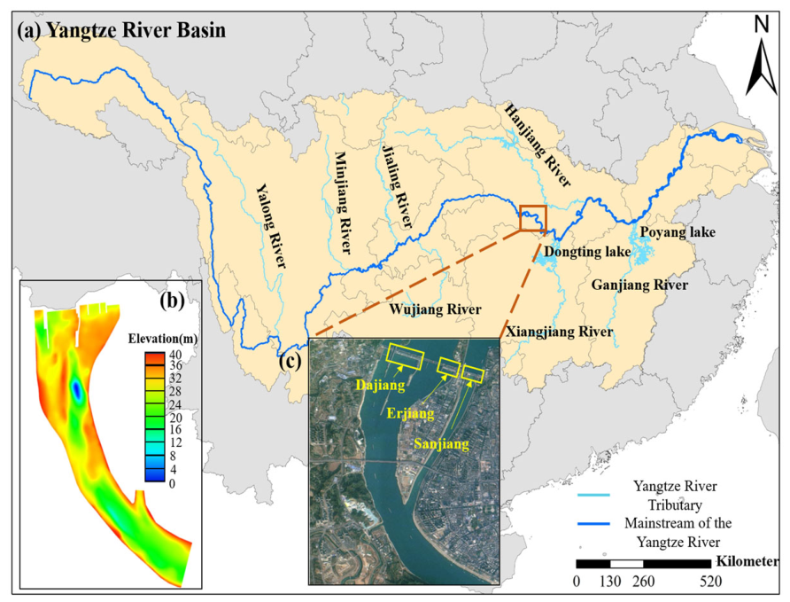
GZB is located in Yichang, Hubei Province, China, and is the lowermost hydropower project on the Yangtze River mainstem. It re-regulates releases from TGD and serves hydropower generation and navigation [30]. At the dam site, Gezhouba Island and Xiba Island divide the river, from right to left when facing downstream, into the DJ, EJ, and Sanjiang (SJ) channels. The main hydraulic structures include the DJ and EJ hydropower plants, discharge sluices, sediment-flushing sluices, ship locks, and guide dikes. The DJ and EJ hydropower plants discharge into separate channels that merge downstream. Figure 1 shows the regional setting, project layout, and riverbed topography.
Figure 1.
Location and physical setting of the study area: (a) the Yangtze River Basin, (b) riverbed topography from GZB to Yichang Hydrological Station, and (c) the layout of the GZB project. The figure was prepared using ArcGIS 10.8 and Tecplot 2025 R1.
The approximately 5 km reach from GZB to Yichang Hydrological Station was selected as the study area. It includes the reach from GZB to Shilihong, approximately 4.5 km downstream of the dam. Historical Chinese sturgeon spawning has been documented in the upper and lower spawning grounds within this reach [20,25,31]. The riverbed downstream of GZB consists mainly of large cobbles, gravel, and bedrock. Pronounced variations in bed elevation, together with alternating deep pools and shoals, generate complex local flow patterns. The study domain encompasses these historical spawning grounds and adjacent river sections, providing a continuous spatial basis for evaluating hydraulic conditions downstream of the two power plants.
2.2. Data Sources
Bathymetric data covering the study reach were provided by the Three Gorges Hydrological Bureau. Historical discharge and water-level data for 1996–2016 were obtained from Li et al. [32]. The hydraulic suitability thresholds were adopted directly from that study. Historical Chinese sturgeon egg-production data were compiled from Liao et al. [33].
Ten-day mean water-temperature data at Yichang Hydrological Station for 1970–1992 and 2004–2016 were provided by the Chinese Sturgeon Research Institute, China Three Gorges Corporation.
Historical near-bed velocity measurements collected on 12 November 2004 were obtained from a non-public report provided by China Yangtze Power Co., Ltd, Yichang, Hubei, China. The report cites Yang et al. [34] as the source of these observations. Additional historical spawning records, the stage–discharge relationship at Yichang Hydrological Station, and engineering parameters and operating requirements were obtained from engineering documentation provided by China Yangtze Power Co., Ltd. Acoustic Doppler current profiler (ADCP) data collected between 12 and 30 June 2025 were provided by the State Key Laboratory of Water Cycle and Water Security, China Institute of Water Resources and Hydropower Research and used for auxiliary evaluation.
2.3. Methods
2.3.1. Overview
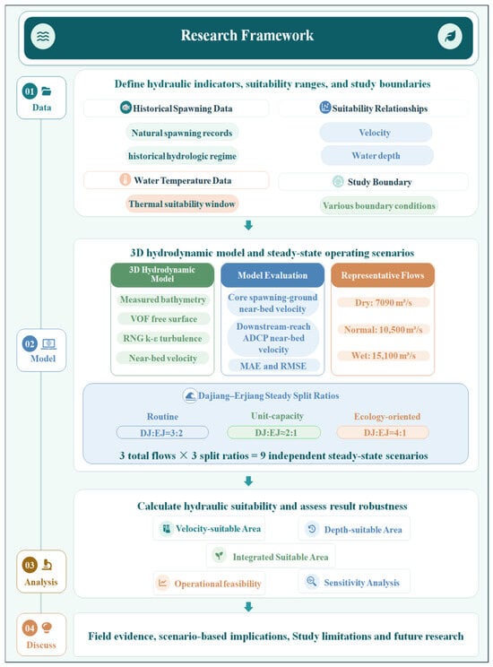
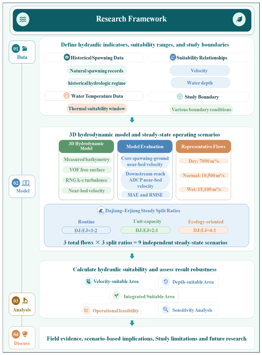
To evaluate whether the near-bed hydraulic conditions of the potential spawning ground can be improved within the existing engineering framework by regulating the total discharge of GZB and the DJ:EJ flow allocation ratio, this study developed a framework for steady-state hydraulic suitability assessment under thermally suitable conditions. The workflow comprised four steps as shown in Figure 2:
Figure 2.
Framework for assessing the hydraulic suitability of potential Chinese sturgeon spawning ground.
- (1)
- Define the hydraulic indicators, suitability ranges, and assessment scope. Near-bed velocity and water depth were selected as the hydraulic indicators, and their suitability ranges were specified. Suitable water temperature was treated as an external prerequisite for ecological operation.
- (2)
- Develop and evaluate the three-dimensional hydrodynamic model. A three-dimensional hydrodynamic model was developed for the reach from GZB to Yichang Hydrological Station. Historical near-bed velocity measurements collected in 2004 within the core spawning area were used to evaluate simulated velocities, while moving-boat ADCP measurements of near-bed velocity collected in 2025 in an adjacent downstream reach outside the model domain provided an auxiliary comparison. Representative discharges for low-, normal-, and high-flow conditions were selected and combined with three DJ flow allocation ratios to define nine steady-state scenarios.
- (3)
- Assess hydraulic suitability, operational feasibility, and threshold sensitivity. Compare the near-bed hydrodynamic characteristics and hydraulically suitable areas among scenarios to identify relatively favorable flow allocation scenarios at each total discharge. Assess operational feasibility against selected engineering constraints and evaluate the sensitivity of suitable-area estimates and scenario rankings to joint shifts in the near-bed velocity and water-depth suitability ranges.
- (4)
- Discuss field evidence, scenario-based implications, study limitations, and future research. Use historical water-temperature records and field-experiment observations to discuss thermal constraints and the implications of the scenario results for ecological operation, including the potential for combining mainstem regulation with local hydraulic enhancement in side channels. Identify study limitations and outline directions for future research.
2.3.2. Ecological Requirements
Water depth and near-bed velocity characterize the vertical space and local flow conditions of the potential spawning ground. Because these conditions can be influenced by GZB releases and the DJ flow allocation ratio, the two variables were selected as indicators of hydraulic suitability [31]. Suitable water temperature was treated as an external prerequisite for ecological operation.
- (1)
- Water depth. Historical records provided by China Yangtze Power Co., Ltd. indicate that water depths during natural spawning events in the Yichang reach from 1996 to 1998 were approximately 4.71–25.0 m. For the present assessment, the narrower range of 5.93–21.29 m was adopted directly from Li et al. as the baseline suitable water-depth range [32].
- (2)
- Near-bed velocity. Historical records from the same source indicate that natural spawning downstream of GZB during 1996–1999 occurred at near-bed velocities of approximately 0.6–2.4 m/s. For the present assessment, the narrower range of 0.73–2.13 m/s was adopted directly from Li et al. as the baseline suitable near-bed velocity range [32].
- (3)
- Water temperature. Water temperature influences gonadal maturation and spawning timing in Chinese sturgeon [33,35]. A water-temperature range of 17.0–20.2 °C was adopted as the thermal prerequisite for ecological operation. All 11 natural spawning events recorded from 2004 to 2016 occurred within this range [32]. Historical spawning records suggest November as a seasonal reference for ecological operation, while the actual timing should be determined from contemporaneous water-temperature observations [35]. Water temperature was not treated as a numerical boundary condition in the three-dimensional hydrodynamic model or as an operational decision variable. It was therefore not included in the calculation of hydraulically suitable area.
- (4)
- Other potential factors. Substrate characteristics and sediment conditions can affect egg attachment, the availability of interstitial spaces, and the risk of egg burial [27,35]. Dissolved oxygen is important for broodstock activity and embryonic development [35]. Temporal variations in discharge and water level should also be considered when planning ecological operation. Reproduction further depends on broodstock gonadal maturity, health, and behavioral responses [35]. This study assumes that the hydraulic regulation scenarios target reproductively capable broodstock that have already entered the study reach.
2.3.3. Three-Dimensional Hydrodynamic Model
Based on the bathymetric data described in Section 2.2, the local geometries of the discharge sluices, sediment-flushing sluices, ship locks, and guide dikes were simplified. A three-dimensional hydrodynamic model of the reach from GZB to Yichang Hydrological Station was then developed using Ansys Fluent 2024 R1, a computational fluid dynamics platform previously applied to river and channel flow simulations [36,37]. The model was used to simulate water levels, velocities, and the spatial distribution of near-bed hydraulic conditions under different total discharges and DJ flow allocation ratios.
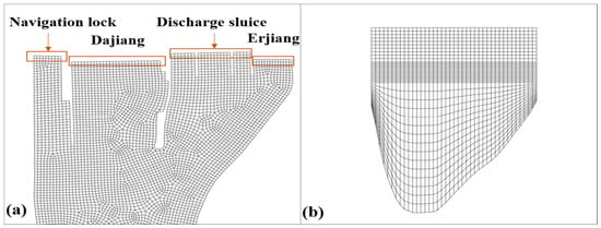
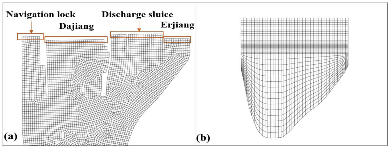
The computational domain was discretized using a structured hexahedral mesh with 40 vertical layers. The mesh was refined near the air–water interface and in areas with pronounced local hydraulic variations. The model contained 475,120 cells, with a minimum grid spacing of 0.1 m and horizontal cell areas ranging from approximately 1.44 to 700 m2. Details of the local mesh are shown in Figure 3.
Figure 3.
Local computational meshes of the three-dimensional hydrodynamic model: (a) plan-view mesh of the reach downstream of GZB; (b) mesh at the outlet cross-section.
Governing equations. The governing equations comprised the continuity equation, the Reynolds-averaged Navier–Stokes (RANS) equations, and a transport equation for the water volume fraction. For incompressible water–air flow without interphase mass transfer, these equations can be expressed as follows.
Continuity equation:
Momentum equation:
Volume fraction transport equation:
where ρ is the fluid density, t is time, is the velocity vector, p is pressure, μeff is the effective dynamic viscosity, g is the gravitational acceleration (g = 9.81 m/s2), Fvol is the surface tension source term, and α is the volume fraction of the water phase in a computational cell (α = 1 indicates that the cell is completely filled with the water phase).
Free-surface treatment. The volume of fluid (VOF) model was used to capture the free surface. It represents water–air two-phase flow on a fixed Eulerian mesh by solving a shared set of momentum equations and tracking the phase volume fractions in each cell. The water volume fraction was used to determine the free-surface position.
Turbulence closure. The renormalization group (RNG) k-ε model was selected for turbulence closure. Its formulation includes a strain-dependent correction to the dissipation-rate equation and has been applied to three-dimensional channel flows [37]. The transport equations for turbulent kinetic energy k and dissipation rate ε in the RNG k-ε model are given as follows:
where ui denotes the mean velocity component in the xi direction; αε and αk are the inverse effective Prandtl numbers for the dissipation rate ε and turbulent kinetic energy k, respectively, and both are set to 1.39; Gk is the turbulent kinetic energy generated by the mean velocity gradient; Gb is the turbulent kinetic energy generated by buoyancy; and are empirical constants ( = 1.42, = 1.68); μeff is the effective viscosity (μeff = μ + μt), μt is the turbulent viscosity coefficient, Cμ is an empirical constants (Cμ = 0.0845).
Near-wall treatment. Non-equilibrium wall functions were used to represent near-wall flow. This treatment accounts for pressure-gradient effects and local departures from equilibrium in the near-wall turbulence.
Numerical solution method. The pressure-implicit with splitting of operators (PISO) algorithm was used for pressure–velocity coupling. Although the algorithm is primarily designed for unsteady-flow calculations, it can also be applied to steady-flow simulations. Its ability to use relatively large time steps substantially improves computational efficiency.
Boundary conditions. The model boundary conditions were specified based on historical hydrological data from Chinese sturgeon spawning periods. The scenarios assumed that the discharge sluices were closed and that releases passed through the DJ and EJ generating units. Accordingly, mass-flow inlet boundary conditions were prescribed at the upstream boundaries, and the total discharge was allocated between the DJ and EJ hydropower plants according to each scenario.
The ship locks operate intermittently, with a discharge of approximately 20–50 m3/s during each operation. This discharge is small relative to the total discharges examined in this study. The ship locks were therefore simplified as stationary wall boundaries, and their discharge effects were neglected. The downstream outlet boundary was specified according to the stage–discharge relationship at Yichang Hydrological Station described in Section 2.2. The sediment-flushing sluices, guide dikes, discharge sluices, riverbanks, and riverbed were all prescribed as no-slip wall boundaries.
Hydraulic variables. Near-bed velocity was extracted at a relative depth of 0.9H below the water surface, where H is the local water depth. This corresponds to a height of 0.1H above the riverbed. Water depth was determined from the difference between the simulated water-surface elevation and the local bed elevation. These variables were used in the subsequent hydraulic suitability assessment.
2.3.4. Model Validation and Auxiliary Evaluation
Model evaluation used historical near-bed velocity measurements within the study reach and ADCP observations from an adjacent downstream reach, as described in Section 2.2. Because the core spawning reach immediately downstream of GZB lies within a restricted safety-control zone, in situ ADCP measurements could not be conducted there during the field surveys of this study. The historical dataset was therefore used to compare simulated and observed near-bed velocities within the model domain. The downstream ADCP observations were compared qualitatively with simulated near-bed velocities at the model outlet, focusing on velocity magnitudes and broad cross-sectional patterns.
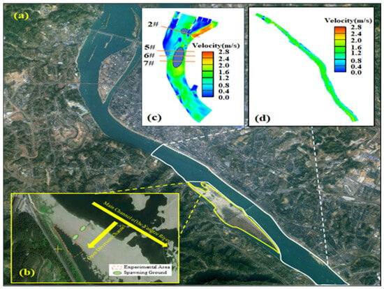
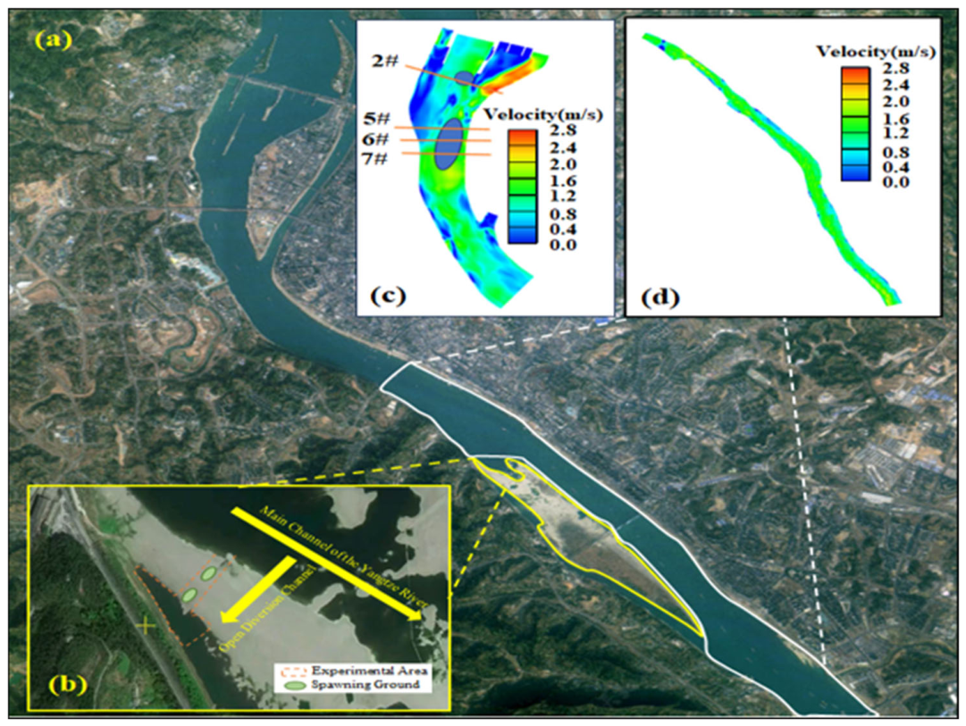
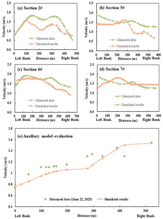
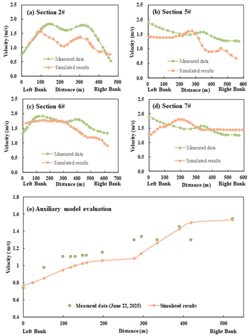
Historical near-bed velocity measurements collected on 12 November 2004 were used for model evaluation. The source of these observations is described in Section 2.2. Measurements at a relative depth of 0.9H below the water surface were compared with simulated velocities at the corresponding locations and relative depth, where H denotes the local water depth. Cross-sections 2#, 5#, 6#, and 7#, located within the upper and lower core spawning areas, were selected for comparison (Figure 4c). The total discharge from GZB on the measurement date was 10,100 m3/s. The comparison used scenario M1.5 (Section 2.3.5), with a total discharge of 10,500 m3/s and a DJ flow allocation ratio of 3:2. The simulated discharge was approximately 4.0% higher than the observed value. The allocation ratio represented conventional GZB operation, based on operational information provided by China Yangtze Power Co., Ltd. Because date-specific allocation records were unavailable, this ratio was assumed for the comparison. The simulation therefore approximated the conditions during the historical measurements.
Figure 4.
Experimental area, model validation sections and ADCP survey area. (a) Reach downstream of GZB; (b) experimental area in the Yanzhiba side channel; (c) model validation sections, “#” denotes a cross-section number.; (d) measured near-bed velocity on 22 June 2025 at 0.9H below the water surface.
Simulated and observed near-bed velocities showed broadly similar magnitudes, with discrepancies in their cross-sectional distributions (Figure 5a–d). Agreement was quantified using the mean absolute error (MAE) and root mean square error (RMSE). The MAE values for cross-sections 2#, 5#, 6#, and 7# were 0.339, 0.283, 0.200, and 0.160 m/s, respectively. The corresponding RMSE values were 0.395, 0.323, 0.247, and 0.189 m/s. Across the 122 comparison points, the overall MAE and RMSE were 0.253 and 0.308 m/s, respectively. These statistics describe model–observation agreement under the approximate boundary conditions used in the comparison.
Figure 5.
Model validation in the core spawning area and auxiliary evaluation in the downstream reach, “#” denotes a cross-section number.
Moving-boat ADCP surveys were conducted from 12 to 30 June 2025 in the reach from Yichang Hydrological Station to Yunchi. Measurements collected at 15: 00 on 22 June 2025 at a relative depth of 0.9H below the water surface were selected for auxiliary evaluation. At that time, the discharge and water level at Yichang Hydrological Station were 15,000 m3/s and 43.57 m, respectively. The comparison used scenario H1.5, with a total discharge of 15,100 m3/s and the assumed conventional DJ allocation ratio of 3:2. The simulated discharge was approximately 0.7% higher than the observed value. Observed velocities at the upstreammost surveyed cross-section were compared with simulated velocities at the model outlet. The two velocity profiles showed broadly comparable magnitudes and an overall increase from the left bank toward the right bank (Figure 5e). Because the surveyed cross-section was downstream of the computational domain (Figure 4d), this comparison provided a qualitative assessment of velocity magnitudes and broad cross-sectional patterns at adjacent locations. It did not constitute a direct validation of velocities within the modeled spawning reach.
Yichang: Hydrological Station, the nearest hydrological station downstream of GZB, is located at the model outlet. Water levels derived from its stage–discharge relationship were used to prescribe the downstream boundary condition. Agreement with these prescribed outlet levels could therefore not serve as independent validation of simulated water levels. Independent water-level observations within the model domain were unavailable, so simulated water levels and depths were not independently validated.
2.3.5. Design of Steady-State Operating Scenarios
Historical records indicate that discharge during the natural spawning season of Chinese sturgeon downstream of GZB was concentrated within approximately 7000–17,000 m3/s. A Pearson type III (P-III) frequency analysis was performed using historical GZB discharge records for the spawning season. Total discharges of 7090, 10,500, and 15,100 m3/s, corresponding to exceedance probabilities of P = 90%, P = 50%, and P = 10%, respectively, were selected to represent low-, normal-, and high-flow conditions.
To examine whether increasing the DJ discharge share could improve hydraulic suitability in its tailrace reach, nine steady-state scenarios were defined by combining the three representative total discharges with three ratios of DJ to EJ discharge. Within each discharge group, total release was held constant and was assumed to pass through the generating units with the discharge sluices closed (Section 2.3.3). According to operational information provided by China Yangtze Power Co., Ltd., the DJ and EJ hydropower plants serve relatively independent power loads and transmission networks. Allocating the entire discharge to DJ would conflict with the requirement to maintain power generation at EJ; therefore, all scenarios retained a share of the total discharge for EJ. Assuming that the specified total discharge is available at GZB, the operational applicability of the scenarios is assessed in Section 3.3 against plant discharge capacities and downstream water-level requirements. The steady-state operating scenarios and the corresponding discharges through the DJ and EJ hydropower plants are summarized in Table 1. The three allocation schemes were defined as follows:
Table 1.
Steady-state operating scenarios and DJ:EJ flow allocation.
- (1)
- Conventional operation scenario (3:2). According to operational information provided by China Yangtze Power Co., Ltd., a DJ flow allocation ratio of 3:2 represents conventional GZB operation [32]. This ratio was adopted as the reference allocation at each representative total discharge.
- (2)
- Installed-capacity-based allocation scenario (approximately 2:1). Discharge was allocated with reference to the installed capacities of the 14 generating units at the DJ hydropower plant and the seven generating units at the EJ hydropower plant, giving a DJ flow allocation ratio of approximately 2:1.
- (3)
- Ecologically oriented operation scenario (4:1). Discharge through DJ was prioritized to examine the potential for expanding hydraulically suitable area in the downstream spawning reach. Meanwhile, 20% of the total discharge was retained for EJ power generation, giving a DJ flow allocation ratio of 4:1.
3. Simulation Results
The nine steady-state scenarios defined in Section 2.3.5 were compared in terms of near-bed velocity, water depth, and hydraulically suitable area. Detailed spatial results for the three scenarios with a total GZB discharge of 15,100 m3/s (H1.5, H2, and H4) are presented in the main text to illustrate differences in hydraulic conditions and the distribution of hydraulically suitable areas among the DJ flow allocation schemes. Corresponding spatial results for the low- and medium-discharge scenarios are provided in Supplementary Figures S1–S12.
3.1. Near-Bed Hydrodynamic Responses in the Spawning Ground Under Different Operating Scenarios
3.1.1. Spatial Distribution of Near-Bed Velocity
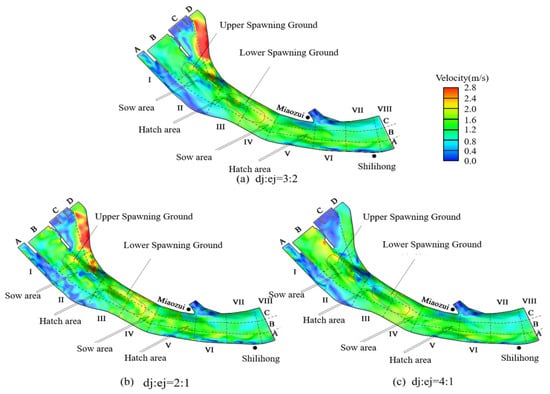
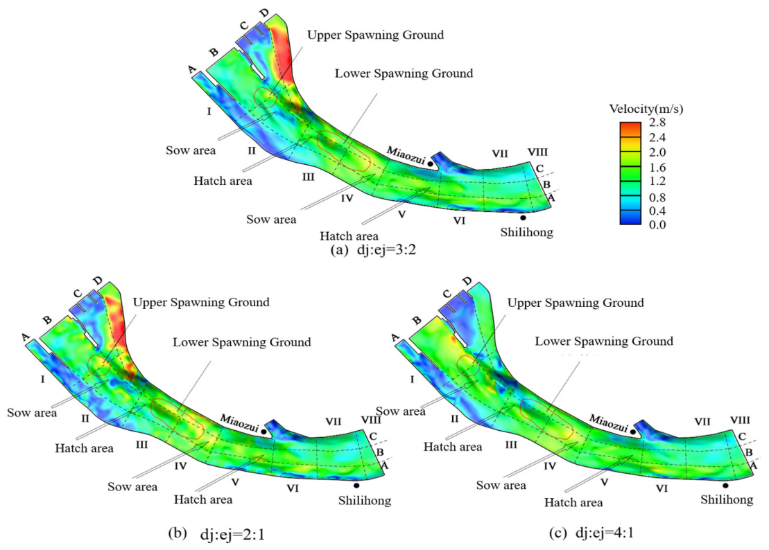
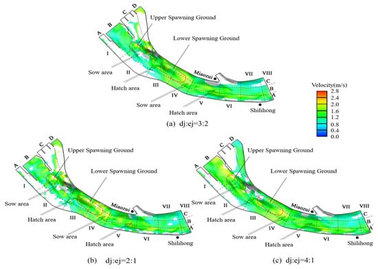
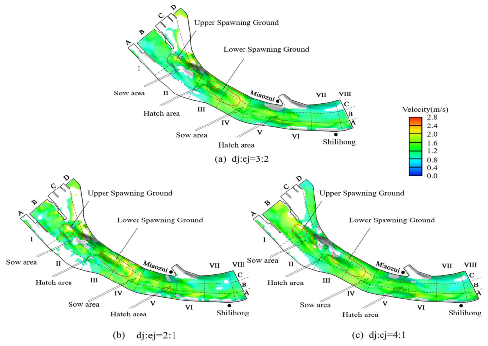
At a total discharge of 15,100 m3/s, adjusting the flow allocation ratio between the DJ and EJ hydropower plants altered the local distribution of near-bed velocity. Figure 6 shows the near-bed velocity fields in the spawning ground under different flow allocation scenarios at a total release of 15,100 m3/s. Because the flow cross-section of the EJ hydropower plant is relatively narrow, near-bed velocity in Zone I-D increased with discharge through EJ. The velocity difference between H1.5 and H4 in Zone I-D was generally 0.2–0.6 m/s, with local differences reaching 1.2 m/s. Excessively high velocity may cause some local areas to exceed the hydraulic suitability range defined in this study. As discharge through the DJ hydropower plant increased, velocity in the downstream reach of DJ also increased. The velocity response was less pronounced in the DJ tailrace than downstream of EJ, consistent with the wider DJ channel. Velocities in most areas downstream of DJ remained within 1.2–2.0 m/s.
Figure 6.
Spatial distributions of near-bed velocity under different scenarios: (Q = 15,100 m3/s) (a) H1.5; (b) H2; (c) H4. Letters A–D and Roman numerals I–VIII provide spatial references across and along the study reach, respectively. Combined labels, such as Zone II-B, identify the areas discussed in the text.
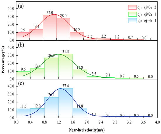
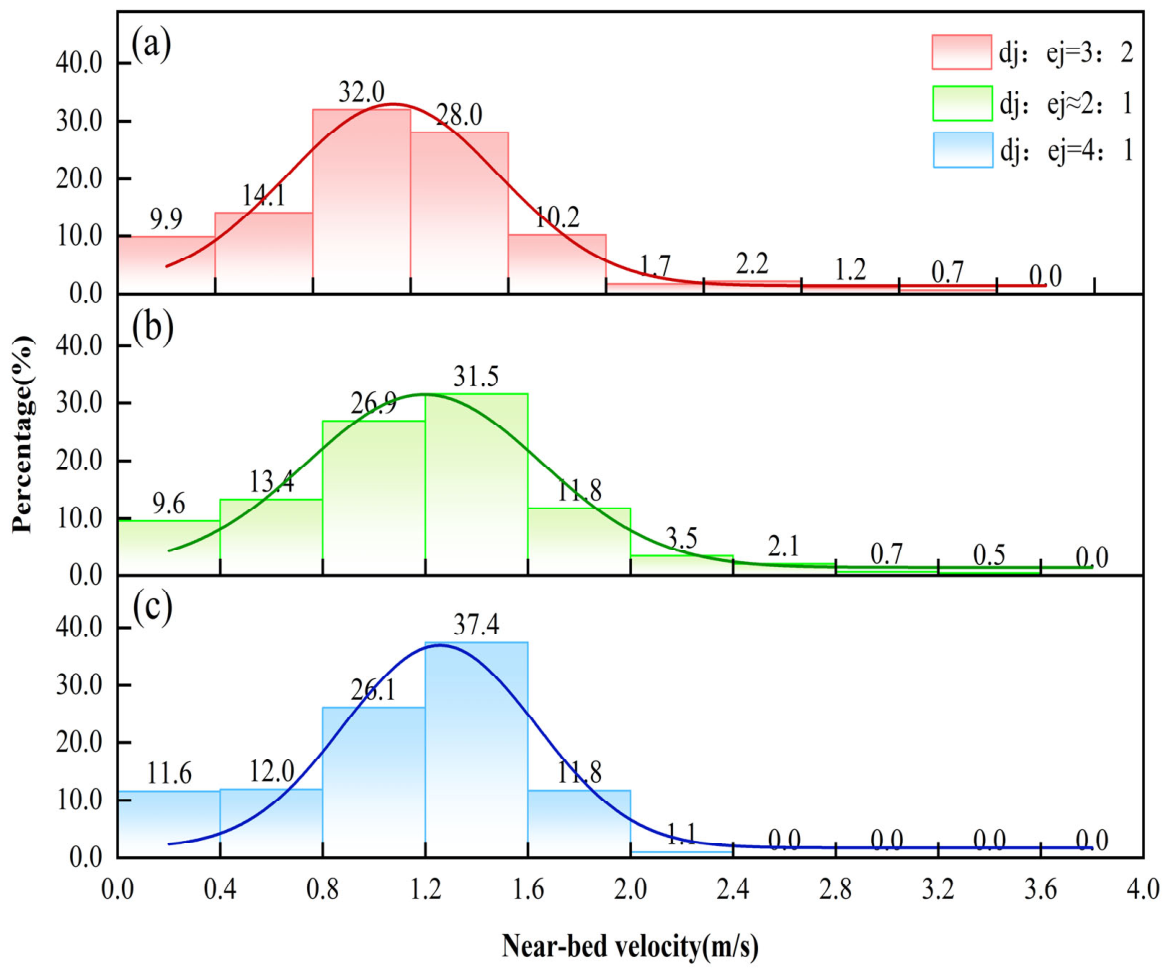
A continuous low-velocity zone persisted near the junction of Zones II-B, II-C, and II-D, coinciding with the deep pool. Figure 7 further summarizes the area proportions within different velocity intervals. Areas with velocities of 0.8–1.6 m/s accounted for 60.0%, 58.4%, and 63.5% of the total area in H1.5, H2, and H4, respectively. In H1.5, the largest proportion of area fell within 0.8–1.2 m/s, accounting for 32%. In H2 and H4, the largest area proportions occurred within 1.2–1.6 m/s, accounting for 31.5% and 37.4%, respectively. Thus, the dominant velocity interval shifted from 0.8–1.2 m/s to 1.2–1.6 m/s as the DJ discharge share increased.
Figure 7.
Area proportions of near-bed velocity classes under different scenarios (Q = 15,100 m3/s). (a) H1.5; (b) H2; (c) H4.
3.1.2. Spatial Distribution of Water Depth
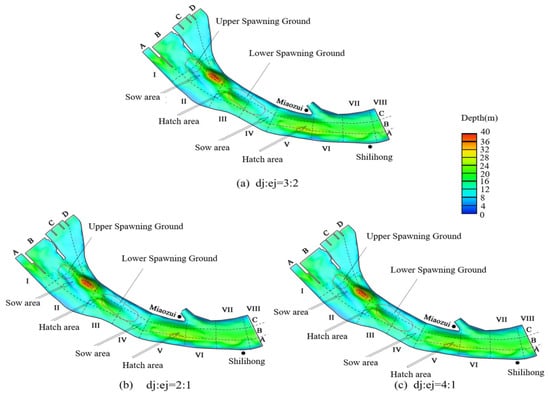
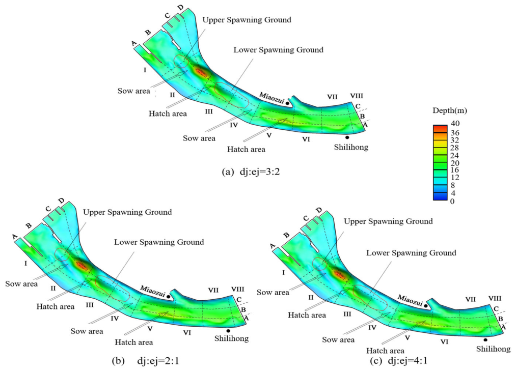
At a total discharge of 15,100 m3/s, the three operating scenarios produced similar spatial patterns of simulated water depth, reflecting the influence of channel topography (Figure 8). The spawning grounds and sow areas are located within Zones I–IV, where much of the riverbed is relatively elevated and simulated water depths generally ranged from 8 to 16 m. However, a deep pool at the confluence of the DJ and EJ channels, near the junction of Zones II-B, II-C, and II-D, had local depths exceeding 30 m. This pool formed the deepest part of the study reach.
Figure 8.
Spatial distributions of water depth under different scenarios: (Q = 15,100 m3/s). (a) H1.5; (b) H2; (c) H4. Letters A–D and Roman numerals I–VIII provide spatial references across and along the study reach, respectively. Combined labels, such as Zone II-B, identify the areas discussed in the text.
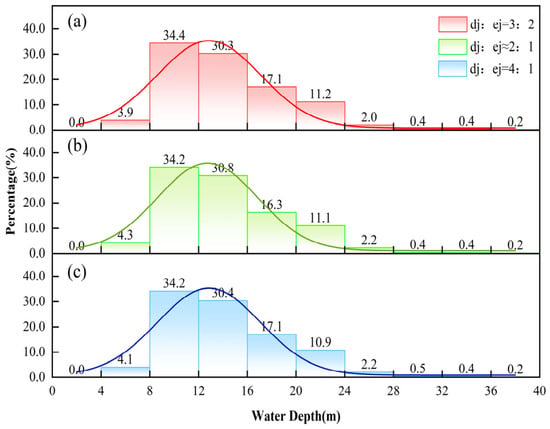
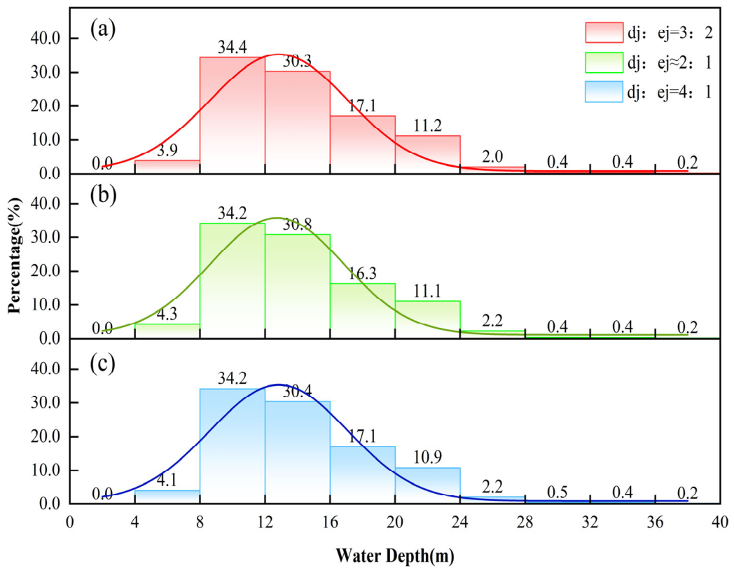
Figure 9 summarizes the area proportions within different water-depth intervals. Under all three scenarios, the 8–12 m interval accounted for the largest proportion of the study area, representing 34.4%, 34.2%, and 34.2% in H1.5, H2, and H4, respectively. More than 90% of the study area had water depths between 8 and 24 m. The similar area proportions across the three scenarios indicate that changing the DJ discharge share had a limited effect on the overall water-depth distribution at this total discharge.
Figure 9.
Area proportions of water-depth classes under different scenarios (Q = 15,100 m3/s). (a) H1.5; (b) H2; (c) H4.
3.2. Hydraulic Suitability of the Potential Spawning Ground
Hydraulic suitability was evaluated using the baseline ranges of 0.73–2.13 m/s for near-bed velocity and 5.93–21.29 m for water depth, as specified in Section 2.3.2 [32]. For each scenario, velocity-suitable and depth-suitable areas were quantified separately, and their spatial overlap defined the integrated hydraulically suitable area, where both criteria were met simultaneously. The spatial distribution of the integrated hydraulically suitable area at a total discharge of 15,100 m3/s is shown in Figure 10, and the area estimates for all nine scenarios are presented in Figure 11.
Figure 10.
Spatial distributions of integrated hydraulically suitable areas under different scenarios (Q = 15,100 m3/s): (a) H1.5; (b) H2; (c) H4. Letters A–D and Roman numerals I–VIII provide spatial references across and along the study reach, respectively. Combined labels, such as Zone II-B, identify the areas discussed in the text.
Figure 11.
Velocity-suitable, depth-suitable, and integrated hydraulically suitable areas under different scenarios.
3.2.1. Areas with Suitable Near-Bed Velocity
Under all three discharge levels, flow through the ship locks and the EJ discharge sluices was excluded from the simulations. Simulated near-bed velocities in extensive, contiguous parts of Zones I-A, I-C, and II-A remained below the lower suitability threshold. The velocity-suitable areas in the upper spawning ground, lower spawning ground, and hatch area remained relatively stable. In contrast, more pronounced differences among scenarios occurred in the upper sow area near the confluence of the DJ and EJ channels, where the channel is deeply incised and flow patterns are complex.
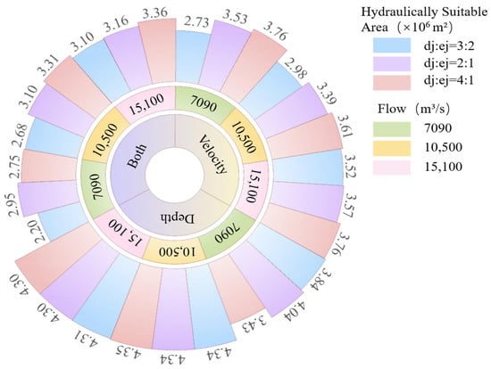
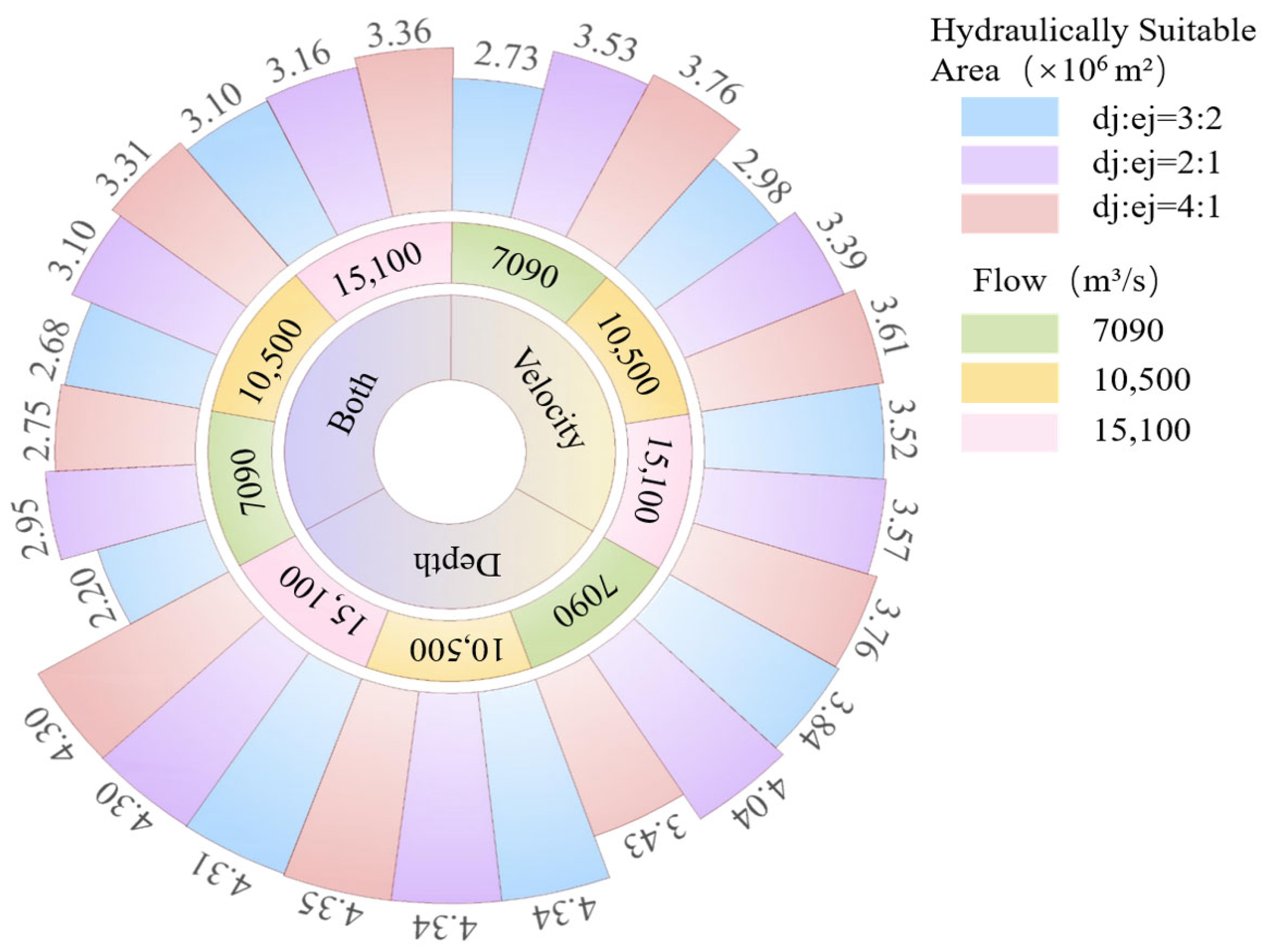
As shown in Figure 11, L1.5 produced the smallest velocity-suitable area, approximately 2.73 × 10⁶ m2, whereas L4 and H4 both yielded the largest area, at 3.76 × 10⁶ m2. At a total discharge of 7090 m3/s, increasing the DJ discharge share from 60% to 80% increased the velocity-suitable area by 1.03 × 10⁶ m2 from L1.5 to L4. At 10,500 m3/s, the corresponding increase from M1.5 to M4 was 0.63 × 10⁶ m2. At 15,100 m3/s, the increase from H1.5 to H4 was 0.24 × 10⁶ m2. Thus, the increase in velocity-suitable area associated with a greater DJ discharge share was smaller at higher total discharges. The velocity-suitable area did not always increase with total discharge. Higher discharge increased velocities in some areas from below the lower threshold to within the suitable range. However, it also caused velocities in parts of the EJ tailrace and confluence zones to exceed the upper threshold. For example, under the 4:1 allocation, the velocity-suitable area was smaller in M4 (3.61 × 10⁶ m2) than in L4 or H4 (both 3.76 × 10⁶ m2).
3.2.2. Areas with Suitable Water Depth
The effects of different flow allocation ratios on the depth-suitable area were relatively limited at total discharges of 10,500 and 15,100 m3/s, whereas larger differences occurred at 7090 m3/s. In Zones I-D and II-B downstream of the EJ hydropower plant, the riverbed elevation is relatively high. When discharge through EJ was low, simulated water depths in these zones fell below the lower suitability threshold. In contrast, the deep pool near the junction of Zones II-B, II-C, and II-D and the main channel within Zones V–VII have relatively low riverbed elevations. Under high-discharge conditions, water depths in these areas could exceed the upper suitability threshold. Water depths in the remaining areas were predominantly within the range of 5.93–21.29 m.
The depth-suitable areas under L1.5, L2, and L4 were 3.84 × 10⁶, 4.04 × 10⁶, and 3.43 × 10⁶ m2, respectively (Figure 11). The largest difference within this discharge group was 0.61 × 10⁶ m2, between L2 and L4. At the two higher total discharges, depth-suitable areas ranged from 4.34 × 10⁶ to 4.35 × 10⁶ m2 at 10,500 m3/s and from 4.30 × 10⁶ to 4.31 × 10⁶ m2 at 15,100 m3/s. Across all nine scenarios, L4 produced the smallest depth-suitable area, whereas M4 produced the largest.
3.2.3. Integrated Hydraulically Suitable Areas
The integrated hydraulically suitable area was determined by applying both the near-bed velocity and water-depth criteria, and its spatial distribution at a total discharge of 15,100 m3/s is shown in Figure 10. Most of the upper spawning ground and lower spawning ground fell within the suitable ranges of both velocity and water depth, with only a few scattered areas where either velocity or water depth exceeded its upper suitability threshold. Under H1.5, the relatively large discharge through EJ caused local near-bed velocities in Zone I-D to exceed the upper suitability threshold. The integrated hydraulically suitable area was approximately 3.10 × 10⁶ m2. Under H2, discharge through EJ decreased, reducing the extent of areas exceeding the upper velocity threshold and increasing the integrated hydraulically suitable area to approximately 3.16 × 10⁶ m2. Under H4, most of the spawning ground and sow area met both suitability criteria, whereas parts of the hatch area exceeded the upper depth threshold. The integrated hydraulically suitable area increased to approximately 3.36 × 10⁶ m2.
When the flow allocation ratio was held constant, increasing total discharge expanded the integrated hydraulically suitable area across the tested scenarios (Figure 11). At 7090 m3/s, L2 produced the largest integrated hydraulically suitable area, reaching 2.95 × 10⁶ m2, which was 34.1% larger than that under L1.5. Under L4, the integrated area decreased to 2.75 × 10⁶ m2. Although its velocity-suitable area was larger than that of L2, its depth-suitable area was smaller. At 10,500 m3/s, M4 produced the largest area, reaching 3.31 × 10⁶ m2, which was 23.5% larger than that under M1.5. At 15,100 m3/s, H4 produced the largest area, reaching 3.36 × 10⁶ m2, which was 8.4% larger than that under H1.5. Thus, L2, M4, and H4 produced the largest integrated hydraulically suitable areas within their respective total-discharge groups.
3.3. Operational Feasibility of the Scenarios
The operational feasibility assessment used the engineering parameters following refurbishment and upgrading, as described in Section 2.2. According to Section 2.2 of the Operating Rules for the Three Gorges (Normal Operation Period)–Gezhouba Cascade (2019 Revision), the DJ hydropower plant originally had a total installed capacity of 1750 MW (14 × 125 MW), a design discharge of 11,550 m3/s (14 × 825 m3/s), and a maximum discharge capacity of 11,928 m3/s. The EJ hydropower plant originally had a total installed capacity of 965 MW (2 × 170 MW + 5 × 125 MW), a design discharge of 6385 m3/s (2 × 1130 m3/s + 5 × 825 m3/s), and a maximum discharge capacity of 6385 m3/s. The refurbishment program was designed to increase the capacity of all 125 MW units to 150 MW. The program envisaged a total installed capacity of 3210 MW (including a separate 20 MW unit), with individual design discharges of 923.1 or 947.9 m3/s for the upgraded 125 MW units. By 2019, turbine refurbishment had been completed for 19 units and generator refurbishment for 14 units. The post-refurbishment aggregate design discharge capacities of the DJ and EJ generating units adopted in this assessment were 13,121 and 6999.5 m3/s, respectively. Among the nine scenarios, the maximum discharges allocated to DJ and EJ were 12,080 and 6040 m3/s, respectively. The DJ discharge prescribed in H4 exceeded the original maximum discharge capacity of 11,928 m3/s but remained below the post-refurbishment design discharge capacity of 13,121 m3/s. Based on these updated parameters, all nine scenarios were within the design discharge limits of the two hydropower plants.
According to section 7.2.3 of the rules, a minimum water level of 39 m at Miaozui is required for downstream navigation. During November–December, GZB releases must meet this requirement, while TGD operation must meet its guaranteed power requirement. The maximum navigable water levels for the DJ and SJ navigation channels and their respective ship locks are 50.6 and 54.5 m, respectively. The downstream water levels corresponding to the design-flood standards of the DJ and EJ hydropower plants are 59.38 and 58.93 m, respectively. Simulated water levels at Miaozui ranged from 40.28 m under L4 to 44.82 m under H2. The corresponding levels under L2, M4, and H4 were 40.84, 42.42, and 44.81 m, respectively. Under the modeled conditions, water levels at Miaozui exceeded the minimum downstream navigation level specified in section 7.2.3 in all nine scenarios.
The field experiment on Chinese sturgeon reproduction conducted in the Yanzhiba side channel from October to December 2025 used mature, captive-reared broodstock, and eggs were detected from 1 to 8 December [22]. Water temperatures during spawning ranged from approximately 18.5 to 19.9 °C in the experimental area, where thermal conditions had been modified by open-channel excavation and diversion [22]. This range was broadly consistent with the suitable spawning-temperature range adopted in this study. Inferred spawning velocities of 0.5–1.0 m/s partially overlapped the adopted velocity range of 0.73–2.13 m/s. However, the experiment took place in a small area enclosed with nets and modified by open-channel excavation and diversion, which differed from the natural GZB spawning reach. Water depths in the experimental area were approximately 2–5 m, below the range of 5.93–21.29 m adopted in this study. As described in Section 2.3.2, historical spawning depths ranged from 4.71 to 25 m. This study adopted the narrower interval reported by Li et al. [32] to evaluate hydraulic suitability in the GZB spawning reach. These field observations provide preliminary evidence of the potential for Chinese sturgeon spawning under managed field conditions.
Although H4 produced the largest integrated hydraulically suitable area among the nine scenarios, its total discharge of 15,100 m3/s may not be available under low- or normal-flow conditions. This study selected three representative total discharges of 7090, 10,500, and 15,100 m3/s to reflect different inflow conditions. L2, M4, and H4 were relatively favorable at these respective discharge levels. Operators could therefore use these scenarios as references for selecting flow allocation ratios according to the available total discharge. In addition, according to section 8.2.5 of the operating rules for the TGD–GZB cascade, targeted ecological operation experiments intended to promote fish reproduction or improve the aquatic environment should be conducted during periods of concentrated fish spawning or when other ecological-operation needs arise, provided that flood-control and hydrological conditions permit. GZB provides re-regulation of releases from the upstream TGD reservoir, while the substantial storage capacity of TGD provides the potential to generate short-duration artificial flow pulses. However, any proposed increase in total release would require a multi-objective cascade-operation assessment of its magnitude, duration, and effects on hydropower generation, navigation, water supply, and reservoir water levels.
At a given available total discharge, the results identify candidate DJ flow allocations that could improve hydraulic suitability without increasing total release. When water temperature is within the suitable reproductive range, GZB operators could use the relatively favorable scenario at the corresponding discharge as a reference for adjusting generating unit operation and allocating turbine discharge between DJ and EJ, in coordination with TGD operation. Implementation would require verification of unit availability and compliance with power system, flood control, navigation, and water supply requirements. Concurrent monitoring of water temperature, hydraulic conditions, generating unit operation, and Chinese sturgeon responses would be needed to evaluate the ecological outcomes and operational effects of the trials.
3.4. Threshold Sensitivity Analysis
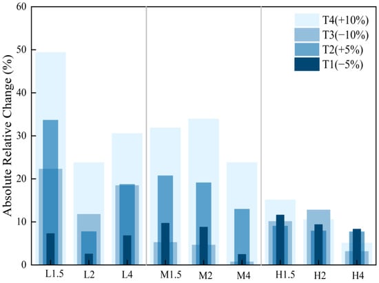
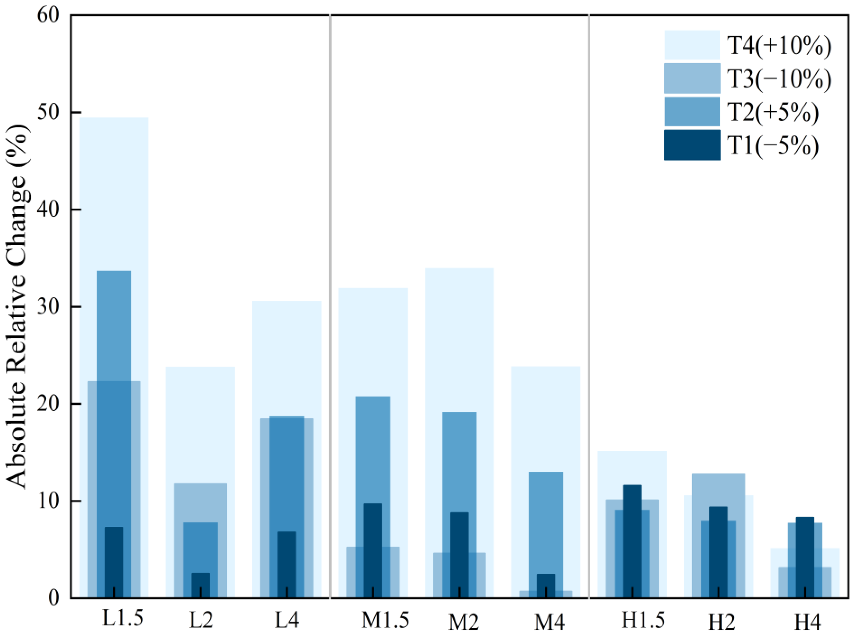
To evaluate the sensitivity of the integrated hydraulically suitable area and the relative ranking of scenarios to the suitability ranges adopted from Li et al. [32], the widths of the suitable near-bed velocity and water-depth intervals were first held constant. The baseline intervals were then shifted jointly to lower and higher values by 5% and 10% of their respective widths. The baseline suitable range for near-bed velocity was 0.73–2.13 m/s, with an interval width of 1.40 m/s, whereas the baseline suitable range for water depth was 5.93–21.29 m, with an interval width of 15.36 m. The ±5% perturbation shifted the velocity and water-depth intervals by ±0.07 m/s and ±0.768 m, respectively, whereas the ±10% perturbation shifted them by ±0.14 m/s and ±1.536 m. The simulated velocity and water-depth fields remained unchanged, and only the thresholds used to classify hydraulic suitability were adjusted. The threshold schemes used in the sensitivity analysis are presented in Table 2. The integrated hydraulically suitable area was recalculated for each of the nine operating scenarios under each threshold-perturbation scheme, and the absolute relative change from the baseline scheme, T0, was then determined. The absolute relative change (ARC) was calculated as follows:
where A0 is the integrated hydraulically suitable area under the baseline thresholds, and Ai is the corresponding area under the ith threshold-perturbation scheme for the same operating scenario.
Table 2.
Joint perturbation schemes for near-bed velocity and water-depth thresholds.
Following the joint perturbation of the velocity and water-depth thresholds, the integrated hydraulically suitable area showed different levels of sensitivity among total-discharge and flow-allocation scenarios (Figure 12). The mean absolute relative changes for the 7090, 10,500, and 15,100 m3/s scenario groups were 19.44%, 14.52%, and 9.25%, respectively, whereas the corresponding maximum absolute relative changes were 49.46%, 33.98%, and 15.17%. For L1.5, the mean and maximum absolute relative changes reached 28.17% and 49.46%, respectively. L1.5 therefore showed the greatest sensitivity among the nine scenarios. In contrast, H4 had a mean absolute relative change of only 6.09% and a maximum absolute relative change of 8.31%, indicating the lowest sensitivity among the nine scenarios. Overall, both the mean and maximum absolute relative changes decreased as total discharge increased. Under all four perturbation schemes, T1–T4, the integrated hydraulically suitable area of L2 remained larger than those of L1.5 and L4. Under T2–T4, the integrated hydraulically suitable areas of M4 and H4 were larger than those of the other two scenarios within their respective discharge groups. Under T1, the areas among the three scenarios were similar within the medium- and high-discharge groups. For M4 and H4, the areas under T0 were larger than those under T1–T4. These results indicate that L2, M4, and H4 generally remained relatively favorable within the tested range of joint threshold perturbations.
Figure 12.
Absolute relative changes in the integrated hydraulically suitable area under joint threshold perturbation.
4. Discussion
4.1. Thermal Suitability Window and Timing of Hydraulic Regulation
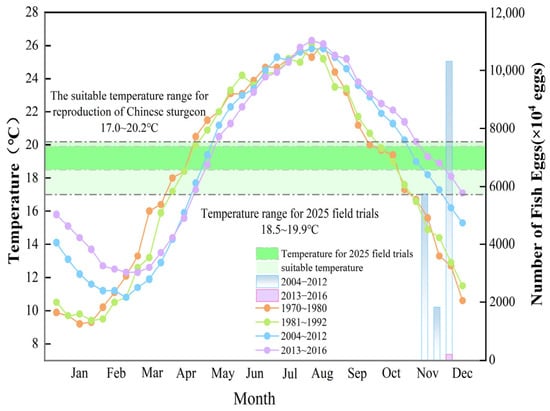
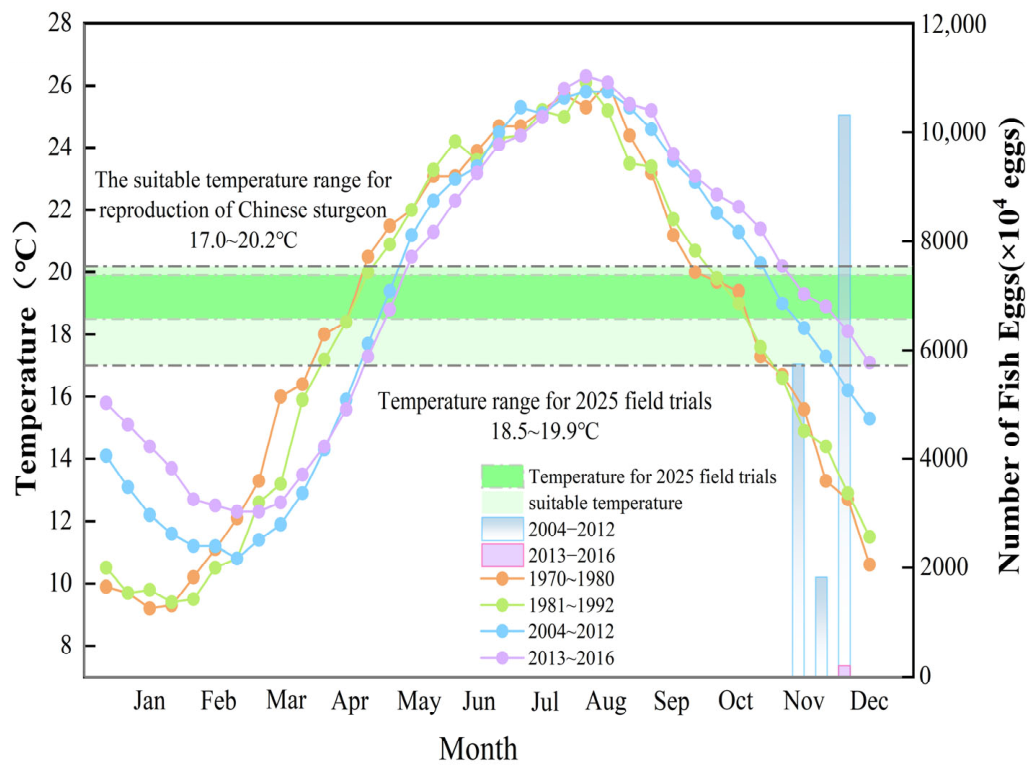
Although this study focuses on hydraulic suitability, the ecological effectiveness of reservoir operation ultimately depends on whether suitable hydraulic conditions can be provided within the suitable thermal window for reproduction. Water temperature has become a critical factor constraining Chinese sturgeon spawning. As shown by the evidence reviewed above, the suitable spawning-temperature range adopted in this study is approximately 17.0–20.2 °C, and natural spawning historically occurred mainly from October to November [27,33]. Mean water temperatures at Yichang Hydrological Station during different periods and historical Chinese sturgeon egg abundance are shown in Figure 13. Based on the historical mean temperature curves, the estimated thermal suitability window shifted from October–November before TGD operation to early November–early December during 2004–2012. During 2013–2016, after the Xiluodu and Xiangjiaba reservoirs began operation, the estimated window shifted further to mid-November–late December. In addition, the intra-annual water-temperature regime has exhibited a pronounced smoothing effect. After TGD began operation, the maximum annual water-temperature range decreased from 16.9 to 15 °C, and it declined further to 14 °C after the Xiluodu and Xiangjiaba reservoirs began operation.
Figure 13.
Mean water temperature at Yichang Hydrological Station during different periods and historical Chinese sturgeon egg abundance.
These thermal changes reflect the combined influences of reservoir operation and climate change. Reservoir operation can delay seasonal cooling and reduce intra-annual temperature variability, while atmospheric warming contributes to the long-term warming trend [28]. An analysis of observations from 2003–2012 also identified air-temperature variations as an important contributor to warming in the Chinese sturgeon spawning reach [29]. Furthermore, upstream cascade reservoirs have been shown to alter the temperature of inflows to the Three Gorges Reservoir, thereby influencing its downstream thermal effects [38]. Climate warming [39] and projected increases in riverine heatwave persistence [40] may further alter the thermal suitability window. Even without additional reservoir construction, changes in upstream inflow temperature, meteorological conditions, and reservoir operation may continue to affect the downstream thermal regime. Further autumn warming could delay cooling into the adopted spawning-temperature range, potentially reducing the temporal overlap of this window with broodstock maturity and suitable hydraulic conditions. Whether the suitable window also becomes shorter would depend on the seasonal temperature trajectory.
Based on the preceding analysis of the Chinese sturgeon reproductive window, November–December provides a seasonal reference for planning ecological operation downstream of GZB. Implementation should be guided by contemporaneous water-temperature observations in the spawning ground and the discharge available during the suitable period. The relatively favorable scenarios L2, M4, and H4 provide references for flow allocation at total discharges of 7090, 10,500, and 15,100 m3/s, respectively. Water temperature was therefore treated as an external prerequisite for implementing the hydraulic regulation scenarios.
The 2025 field experiment provides evidence under specific local management conditions. As discussed in Section 3.3, the 18.5–19.9 °C range was observed during spawning at the Yanzhiba experimental site following open-channel excavation and diversion. By introducing mainstem water into the experimental area, the diversion moderated cooling and extended the period of suitable temperatures [22]. However, differences in bed morphology, hydrodynamic conditions, and thermal structure between the mainstem and the side channel limit the direct applicability of these observations to the modeled GZB spawning reach. Future water-temperature monitoring in downstream reaches should be integrated with three-dimensional coupled hydrodynamic–thermal simulations to assess the timing and duration of the thermal suitability window under different inflow conditions and climate scenarios. Future studies could also apply artificial neural networks (ANNs) to forecast water temperature [41], including recurrent neural networks (RNNs) [42] and their long short-term memory (LSTM) variants [43]. These forecasts could support timely coordination of hydraulic regulation with suitable thermal conditions.
4.2. Implications of Synergizing Mainstem Operation with Local Hydraulic Enhancement in Side Channels
At present, hydraulic conditions in the GZB spawning reach are influenced primarily by releases from the DJ and EJ hydropower plants. Construction of the Three Gorges New Navigation Channel officially began on 8 June 2026. The future construction and operation of this project may impose additional hydraulic disturbances on the historical spawning reach downstream of GZB. Under these circumstances, habitat restoration may benefit from complementary measures alongside mainstem flow regulation. As discussed in Section 3.3 and Section 4.1, the 2025 field experiment provides observational context for managed reproduction trials. Combining mainstem flow regulation with local hydraulic enhancement may offer a complementary engineering approach for expanding potential spawning space.
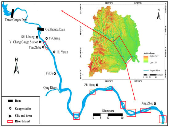
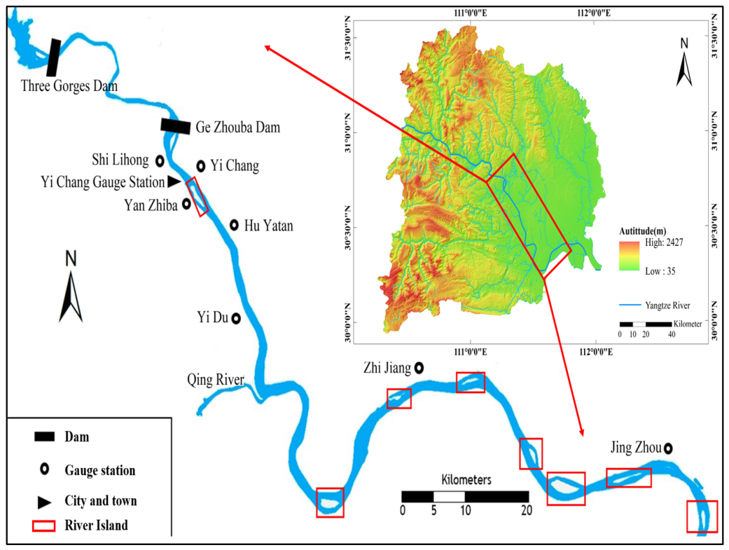
In a related study, Liu et al. [44] developed a three-dimensional hydrodynamic model for an approximately 5 km reach in the Yanzhiba side channel. They quantified the spatial distribution of hydraulic suitability for Chinese sturgeon within the experimental area under different discharge conditions, thereby providing a basis for selecting sites for field experiments on natural Chinese sturgeon spawning. The preliminary success of the 2025 field experiment suggests that, under controlled field conditions, artificially managed hydraulic and thermal conditions may support spawning by mature broodstock. The experimental spawning site was located in a side channel outside the modeled GZB spawning reach. From an ecological-engineering perspective, these observations suggest that the diversity of potential spawning spaces may be increased by combining mainstem flow regulation with targeted local improvements in side channels. Figure 14 shows that numerous mid-channel islands and side channels are distributed throughout the Yichang reach of the middle Yangtze River and the downstream reaches. Their potential as experimental spawning sites would require individual assessments of hydraulic connectivity, substrate conditions, and thermal and hydraulic suitability. Combining reach-scale operating rules with targeted side-channel restoration could distribute reproductive habitats more widely and establish a more adaptive restoration framework.
Figure 14.
Distribution of representative mid-channel islands and anabranching reaches in the Yichang–Jingjiang reach downstream of GZB.
In practice, the three relatively favorable scenarios simulated in this study could be used as candidate mainstem operating conditions for future coupled simulations of the mainstem and side channels. Boundary conditions for individual experimental sites would need to account for local water levels and water exchange with the mainstem. Local hydraulic suitability within side channels could potentially be improved by diverting supplementary flow from the mainstem and generating local currents with submersible pumps. The feasibility and ecological effects of these measures would require site-specific modeling and field trials, subject to hydropower generation, flood-control, navigation, and water-supply constraints. Future studies could further evaluate how modifications to local water-temperature and hydrodynamic conditions affect spawning, hatching, juvenile habitat use, and growth, thereby exploring the small-scale establishment of experimental habitats supporting Chinese sturgeon reproduction and early development.
4.3. Study Limitations and Future Research
The reproductive response of Chinese sturgeon is characterized by pronounced nonlinearity and multifactor coupling. This study focused on near-bed velocity and water depth because these variables can be regulated through reservoir operation and quantified using a three-dimensional hydrodynamic model. Suitable water temperature was treated as an external prerequisite. Other factors, including substrate conditions, dissolved oxygen, sediment deposition, broodstock maturity, and behavioral responses, are equally important but were not incorporated into the hydraulic-screening framework. Accordingly, the results represent only the hydraulic suitability of potential spawning grounds and should not be interpreted as complete spawning-habitat suitability or actual reproductive success.
Model validation also has several limitations. The 2004 validation relied on approximate inlet boundary conditions, and the 2025 ADCP observations provided only a qualitative comparison at an adjacent downstream location outside the model domain. Water levels and depths were not independently validated because independent observations within the model domain were unavailable. The effects of model uncertainty on suitable-area estimates and scenario comparisons require further assessment.
The steady-state scenarios do not resolve transient hydraulic responses or the duration of suitable conditions. The operational assessment considered the adopted post-refurbishment plant discharge capacities and selected navigation-related water-level requirements. Detailed generating unit schedules and trade-offs among hydropower generation, flood control, navigation, and water supply remain to be evaluated. Future studies should integrate more complete generating-unit operation records with synchronous field observations of velocity, water level, discharge, and water temperature under coordinated TGD–GZB cascade operation. These data would support the development of a dynamically coupled evaluation framework incorporating water temperature, hydrodynamics, and other key environmental factors, together with uncertainty assessment. Enhanced field monitoring of Chinese sturgeon behavioral responses is also needed, together with iterative optimization under varying hydrological and operational boundary conditions.
5. Conclusions
This study used a three-dimensional hydrodynamic model to evaluate hydraulic suitability under nine steady-state operating scenarios in the historical spawning reach of Chinese sturgeon downstream of GZB. Water temperature within the suitable reproductive range was treated as a prerequisite for hydraulic regulation. Threshold sensitivity, engineering constraints, and evidence from the 2025 field experiment were considered when interpreting the results. The scenario results concern hydraulic suitability and do not predict reproductive success. The main conclusions are as follows:
- The model was evaluated using historical near-bed velocity measurements from four representative cross-sections within the core spawning area of Chinese sturgeon in 2004, under approximate inlet boundary conditions. The overall MAE and RMSE were 0.253 and 0.308 m/s, respectively. The 2025 ADCP observations provided an auxiliary qualitative comparison outside the model domain.
- Total discharge primarily controlled the overall level of near-bed velocity in the study reach, whereas the DJ:EJ flow allocation ratio mainly altered the local velocity distribution and hydraulic spatial heterogeneity in the tailrace and confluence zones of the two hydropower plants. By comparison, water depth responded less strongly to changes in the flow allocation ratio and was governed mainly by riverbed topography and the downstream controlling water level.
- At total discharges of 7090, 10,500, and 15,100 m3/s, L2, M4, and H4, respectively, produced the largest integrated hydraulically suitable areas among the tested flow allocations. All scenarios were within the adopted post-refurbishment plant discharge capacities, and their operational feasibility was discussed in relation to operating constraints. Application within the thermal suitability window remains subject to verification of actual unit availability and operating requirements.
- Joint threshold perturbation of both velocity and water depth showed that L2, M4, and H4 generally remained relatively favorable under the tested shifts of ±5% and ±10% of their respective interval widths.
- Historical mean water-temperature records indicate a shift in the estimated thermal suitability window toward November–December. Its timing in a given year should be determined from contemporaneous observations. The 2025 field experiment provides preliminary evidence of Chinese sturgeon spawning under locally managed hydraulic and thermal conditions in a side channel. Differences in water depth and local management conditions limit the direct applicability of these observations to the modeled GZB spawning reach.
Supplementary Materials
The following supporting information can be downloaded at: https://www.mdpi.com/article/10.3390/su182211501/s1.
Author Contributions
W.L.: Writing—original draft, Formal analysis. J.L.: Writing—review & editing, Supervision. Y.L.: Data curation, Conceptualization. Y.Z.: Software, Visualization, Investigation. Q.P.: Resources, Funding acquisition, Investigation. Y.R.: Investigation. D.Z.: Methodology. B.Z.: Validation. T.J.: Project administration, Investigation. All authors have read and agreed to the published version of the manuscript.
Funding
This work was supported by the Joint Fund for Yangtze River Water Science Research of the National Natural Science Foundation of China (Grant No. U2240214), the National Key Research and Development Program of China (Grant No. 2025YFD2400105), and the Natural Science Foundation of Hubei Province (Grant No. 2024AFD356).
Institutional Review Board Statement
Not applicable.
Informed Consent Statement
Not applicable.
Data Availability Statement
Restrictions apply to the availability of these data. Data were obtained from China Yangtze Power Co., Ltd. and are available from the authors with the permission of China Yangtze Power Co., Ltd.
Conflicts of Interest
Author Yufeng Ren was employed by the company China Changjiang Power Co., Ltd. The remaining authors declare that the research was conducted in the absence of any commercial or financial relationships that could be construed as a potential conflict of interest.
References
- Goodwell, A.; Campbell, N. An information theory-based approach to characterize drivers of upstream salmon migration. PLoS ONE 2022, 17, e0269193. [Google Scholar] [CrossRef] [Scilit]
- Gong, W.-T.; Li, S.; Jiang, W.; Cao, R.; Zhu, W.-L.; Xing, L. Ecological operation practice of artificial flood peak for fish spawning. China Rural Water Hydropower 2024, 65–72. (In Chinese) [Google Scholar] [CrossRef]
- Lin, J.; Li, Y.; Liu, Y.; Peng, Q.; Zhang, D.; Jin, T. Recent progress in ecological operation and adaptive management for stimulating fish natural spawning. J. Hydraul. Eng. 2022, 53, 483–495. (In Chinese) [Google Scholar] [CrossRef]
- Lv, Z.; Wang, G.; Zhang, P.; Ai, X.; Cao, X.; Zheng, W.; Mu, Z.; Yu, B. Optimizing flow regime for the Four Major Chinese Carps by integrating habitat suitability within reservoir operation. J. Hydrol. 2023, 626, 130226. [Google Scholar] [CrossRef] [Scilit]
- Dai, L.; Liu, X.; Li, Q.; Cao, G.; Liu, H.; Gao, X.; Zhou, W.; Jiang, W. Assessment of habitat suitability for spawning schooling of four major Chinese carps in Yichang River section of Yangtze River. J. Yangtze River Sci. Res. Inst. 2026, 43, 58–66. (In Chinese) [Google Scholar] [CrossRef]
- Ren, Y.; Zhao, L.; Cao, H.; Ruan, Y. Influence of ecological regulation of cascade reservoirs in the lower Jinsha River. Ecol. Environ. Monit. Three Gorges 2020, 5, 8–13. (In Chinese) [Google Scholar] [CrossRef]
- Lei, H.; Huang, G.; Lu, Y.; Xie, S.; Yang, Z.; Li, C.; Tong, D.; Yuan, T.; Huang, D.; Chen, F. Effects of ecological operation of cascaded hydraulic hubs on the reproduction of fish species with drifting eggs in the middle and lower Hanjiang River. J. Hydroecol. 2025, 46, 22–34. (In Chinese) [Google Scholar] [CrossRef]
- Hu, P.; Yang, Z.; Wang, H.; Yan, X.; Zeng, Q. A grouped ecological operation technique to accommodate the spawning needs of different fish species. Sci. Sin. Technol. 2025, 55, 955–967. (In Chinese) [Google Scholar] [CrossRef] [Scilit]
- Cao, G.; Yang, X.; Fan, X.; Lin, Y.; Huang, Y. Ecological and environmental protection work practice of cascade reservoirs from Lower Jinsha River to Three Gorges. Yangtze River 2022, 53, 28–33. (In Chinese) [Google Scholar] [CrossRef]
- Tang, X.-Y.; Cao, X.-Z.; Wang, W.-L. Ecological regulation of hydraulic engineering projects in USA and Canada and its reference for China. J. Ecol. Rural Environ. 2013, 29, 394–402. (In Chinese) [Google Scholar] [CrossRef]
- Loire, R.; Piégay, H.; Malavoi, J.-R.; Beche, L.; Dumoutier, Q.; Mosseri, J.; Kerjean, C. Unclogging improvement based on interdate and interreach comparison of water release monitoring (Durance, France). River Res. Appl. 2019, 35, 1107–1118. [Google Scholar] [CrossRef] [Scilit]
- Beesley, L.; King, A.J.; Gawne, B.; Koehn, J.D.; Price, A.; Nielsen, D.; Amtstaetter, F.; Meredith, S.N. Optimising environmental watering of floodplain wetlands for fish. Freshw. Biol. 2014, 59, 2024–2037. [Google Scholar] [CrossRef] [Scilit]
- Rolls, R.J.; Growns, I.O.; Khan, T.A.; Wilson, G.G.; Ellison, T.L.; Prior, A.; Waring, C.C. Fish recruitment in rivers with modified discharge depends on the interacting effects of flow and thermal regimes. Freshw. Biol. 2013, 58, 1804–1819. [Google Scholar] [CrossRef] [Scilit]
- Rolls, R.J. Assessing Effects of Flow Regulation and an Experimental Flow Pulse on Population Size Structure of Riverine Fish with Contrasting Biological Characteristics. Environ. Manag. 2021, 67, 763–778. [Google Scholar] [CrossRef] [Scilit]
- Hansen, A.G.; Lepak, J.M.; Pate, W.M.; Brauch, D.; Avila, B.W. Just water over the dam? Reservoir fishery disruption following drought-mediated reoperation for environmental flows. Ecosphere 2025, 16, e70412. [Google Scholar] [CrossRef] [Scilit]
- Du, H.-J.; Wang, B.-Z.; Liu, J.-J.; Jiang, W.; Li, Z.-Y. Reflections on the conservation strategies for germplasm resources of Chinese sturgeon (Acipenser sinensis). Acta Hydrobiol. Sin. 2025, 49, 012509. (In Chinese) [Google Scholar] [CrossRef]
- Liu, H.-Z. Discussion on the conservation of Chinese sturgeon. Acta Hydrobiol. Sin. 2024, 48, 1603–1609. (In Chinese) [Google Scholar] [CrossRef]
- Zhuang, P.; Zhang, T.; Zhao, F.; Feng, G.-P.; Zhang, L.-Z.; Liu, J.-Y. Conservation of the wild population of Chinese sturgeon (Acipenser sinensis) and its habitats. Acta Hydrobiol. Sin. 2024, 48, 1625–1632. (In Chinese) [Google Scholar] [CrossRef]
- Wei, Q.; Chen, X.; Yang, D.; Liu, J.; Zhu, Y.; Zheng, W. Variations in spawning stock structure of Acipenser sinensis within 24 years since damming of Gezhouba Dam. J. Fish. Sci. China 2005, 12, 452–457. (In Chinese) [Google Scholar] [CrossRef]
- Wei, Q. Conservation of Chinese sturgeon (Acipenser sinensis) based on its life history: Dilemma and breakthrough. J. Lake Sci. 2020, 32, 1297–1319. (In Chinese) [Google Scholar] [CrossRef] [Scilit]
- Jiang, W.; Du, H.-J.; Chen, P.; Yang, J.; Li, Z.-Y. Process, difficulties, and directions of species conservation of Chinese sturgeon. Acta Hydrobiol. Sin. 2024, 48, 1617–1624. (In Chinese) [Google Scholar] [CrossRef]
- Dai, L.-Q.; Jiang, W.; Li, Z.-Y.; Chang, J.-B.; Su, W.; Liu, X.; Li, Q.-P.; Zhu, J.-Z.; Cao, G.-R. Open-channel diversion on improving water temperature at the natural spawning experimental ground for Chinese sturgeon in the Yanzhiba branch, Yichang. Acta Hydrobiol. Sin. 2026, 50, 082611. (In Chinese) [Google Scholar] [CrossRef] [Scilit]
- Li, P. Assessing Changes in EcoHydraulic Environment Suitability for Chinese Sturgeon (Acipenser sinensis) Spawning Grounds. Master’s Thesis, Shanghai Ocean University, Shanghai, China, 2025. (In Chinese) [Google Scholar] [CrossRef]
- Tu, F.; Huang, Z.; Shi, X.; Zhang, S.; Zhu, J.; Liang, D.; Yao, B.; Chang, J. Velocity response characteristics of contact behavior of Chinese sturgeon in natural aquatic spawning environment. J. Shanghai Ocean Univ. 2026, 35, 270–278. (In Chinese) [Google Scholar] [CrossRef]
- Huang, A.; Yao, J.; Zhu, J.; Gao, X.; Jiang, W. Optimization of the flow conditions in the spawning ground of the Chinese sturgeon (Acipenser sinensis) through Gezhouba Dam generating units. Sci. Rep. 2021, 11, 14403. [Google Scholar] [CrossRef] [Scilit]
- Chen, M.-Q.; Tuo, Y.-C.; Li, J.; Wang, Q.-G. Preliminary study on index system describing hydraulic characteristics of fish spawning ground. J. Hydraul. Eng. 2013, 44, 1303–1308. (In Chinese) [Google Scholar] [CrossRef]
- Liu, W.; Li, J.; Li, P.; Ban, X.; Wu, J.; Zhang, H.; Shen, L.; Liu, Z.; Du, H. Variation regularity of bottom substrate characteristics in spawning ground of Chinese sturgeon downstream the Gezhouba Dam from impounding of the Three Gorge Reservoir. Acta Hydrobiol. Sin. 2024, 48, 568–578. (In Chinese) [Google Scholar] [CrossRef]
- Xiao, Z.; Sun, J.; Lin, B.; Yuan, B. Multi-timescale changes of water temperature due to the Three Gorges Reservoir and climate change in the Yangtze River, China. Ecol. Indic. 2023, 148, 110129. [Google Scholar] [CrossRef] [Scilit]
- Hui, E.; Mao, J.; Dai, H. Effects of temperature variation at upstream of the Three Gorges Reservoir on Chinese sturgeon spawning reach. Adv. Sci. Technol. Water Resour. 2018, 38, 44–48. (In Chinese) [Google Scholar] [CrossRef]
- Li, S.; Jiang, W.; Li, B.; Dang, Y.; Su, W.; Dai, L. Fish Community Structure and Diversity below Gezhouba Dam in Yangtze River. J. Hydroecol. 2024, 45, 121–130. (In Chinese) [Google Scholar] [CrossRef]
- Li, P.; Ban, X.; Wu, J.; Zhang, H.; Li, J.; Shen, L.; Liu, Z.; Du, H. Kernel density estimation of egg attachment areas aids in revealing spatiotemporal changes in Chinese sturgeon spawning grounds. Water Biol. Secur. 2025, 4, 100311. [Google Scholar] [CrossRef] [Scilit]
- Li, Y.; Lin, J.; Liu, Y.; Yao, W.; Zhang, D.; Peng, Q.; Qian, S. Refined operation of cascade reservoirs considering fish ecological demand. J. Hydrol. 2022, 607, 127559. [Google Scholar] [CrossRef] [Scilit]
- Liao, X.; Zhu, B.; Chang, J. Study on conservation of Chinese sturgeon. Yangtze River 2017, 48, 16–20, 35. (In Chinese) [Google Scholar] [CrossRef]
- Yang, Y.; Tan, X.; Chang, J.; Yan, Z. Chinese sturgeon (Acipenser sinensis) preference velocities from river simulation. J. Hydraul. Eng. 2007, 38, 531–534, 541. (In Chinese) [Google Scholar] [CrossRef]
- Luo, H. Key Environmental Factors and Suitability of Chinese Sturgeon Reproduction. Ph.D. Thesis, China Institute of Water Resources and Hydropower Research, Beijing, China, 2013. (In Chinese) [Google Scholar]
- Li, M.; Kong, D.; Guo, Q.; Liu, X.; Yao, J.; Hu, J.; Chen, L. Investigation of Movement and Deposition Behaviors of Solid Particles in Hydraulic Water Reservoir via the CFD-DEM Coupling Method. Chin. J. Mech. Eng. 2022, 35, 118. [Google Scholar] [CrossRef] [Scilit]
- Xie, P.; Li, C.; Lv, S.; Zhang, F.; Jing, H.; Li, X.; Liu, D. Numerical Simulation of 3D Flow Structure and Turbulence Characteristics near Permeable Spur Dike in Channels with Varying Sinuosities. Sustainability 2023, 15, 15862. [Google Scholar] [CrossRef] [Scilit]
- Xiao, Z.; Sun, J.; Lin, B.; Wang, J. Attribution of Thermal Regime Changes in the Upper Yangtze River: Disentangling Discharge- and Temperature-Mediated Pathways. Water 2026, 18, 2495. [Google Scholar] [CrossRef] [Scilit]
- Leslie, M. Climate Change Hammers Hydropower. Engineering 2025, 47, 11–13. [Google Scholar] [CrossRef] [Scilit]
- Chen, Y.; Su, Z.; Woolway, R.I.; Wanders, N.; Wu, S.; Huang, Z.; Luo, M. Persistent river heatwaves are emerging worldwide under climate change. Nat. Commun. 2026, 17, 94. [Google Scholar] [CrossRef] [Scilit]
- Chaves, P.; Chang, F.-J. Intelligent reservoir operation system based on evolving artificial neural networks. Adv. Water Resour. 2008, 31, 926–936. [Google Scholar] [CrossRef] [Scilit]
- Xu, R.; Xia, J.; Li, Z.; Miao, C.; Zhou, M.; Chen, C.; Lu, J. Prediction method of runoff and sediment processes based on RNN and its application: A case study of the Lower Yellow River. Eng. J. Wuhan Univ. 2024, 57, 571–581. (In Chinese) [Google Scholar] [CrossRef]
- Zheng, T.; Wu, M.; Zhang, D.; Jin, J.; Lin, J.; Sun, S. Simulating water temperature in reservoir using improved LSTM model. Trans. Chin. Soc. Agric. Eng. 2025, 41, 144–153. (In Chinese) [Google Scholar] [CrossRef]
- Liu, X.; Zhang, Q.; Jiang, W.; Cao, G.; Li, Q.; Dai, L. Research on the selection strategy for natural spawning trial site of important aquatic species based on hydrological and hydrodynamic requirements. Eng. J. Wuhan Univ. 2025, 1–15. (In Chinese) [Google Scholar] [CrossRef]

Disclaimer/Publisher’s Note: The statements, opinions and data contained in all publications are solely those of the individual author(s) and contributor(s) and not of MDPI and/or the editor(s). MDPI and/or the editor(s) disclaim responsibility for any injury to people or property resulting from any ideas, methods, instructions or products referred to in the content. |
© 2026 by the authors. Licensee MDPI, Basel, Switzerland. This article is an open access article distributed under the terms and conditions of the Creative Commons Attribution (CC BY) license.