


Abstract
From its conception, ICZM has lain at the interface of science, policy and practice; this complexity can be addressed with place-based applications in local case studies. To support coastal decision-making towards sustainability, scientists developed and applied diverse methodologies. This research investigated ICZM research application, following the PRISMA guidelines; the Systematic Literature Review (SLR) included 134 case studies from a Scopus search of 502 results. This SLR examines location, approaches, project rationale, applied methodologies, and stakeholders’ involvement adopted across case studies. The Euro-Mediterranean region is the main territory of case study application, as expected from the support of the ICZM Protocol of the Barcelona Convention and the EU ICZM strategy. From the reviewed literature, the discussion focuses on the involvement of stakeholders, the consideration of climate-change impacts, and fisheries management within ICZM. This research proposes further research to assess the potential of the Fuzzy Cognitive Mapping (FCM) method for ICZM applications based on Local Ecological Knowledge.
1. Introduction
The introduction begins by presenting ICZM’s origin and development, then explains its transdisciplinary facet.
1.1. From Sectoral to “Integrated” Coastal Management
Coastal area management practices started in the late 1960s, were largely sector-specific and focused on limited onshore uses [1]. In 1989, the Charleston Workshop gathered international coastal management experts, who reviewed progress in coastal zone management and recognized scientists’ call to move from sectoral approaches to a certain integration of management programs. “Integration” referred to a holistic acknowledgement of human activities within coastal zones [2]. Sectoral management, where fisheries, tourism, urban development, and conservation are planned isolated, intensifies conflicts, exacerbates resource depletion, and deteriorates ecosystems [3,4,5] and therefore does not improve sustainable solutions in coastal zone issues. The goal of the Charleston Workshop was to define a framework to balance environmental protection, public use and economic development. They agreed on the terminology: Integrated Coastal Zone Management (ICZM), and its definition: “a dynamic process in which a coordinated strategy is developed and implemented for the allocation of environmental, socio-cultural, and institutional resources to achieve the conservation and sustainable multiple use of the coastal zone” [2]. The “integrated” coastal management concept evolved within scientific literature and international political agreements through different terminologies. The Agenda 21 of the 1992 Rio Earth Summit referred to integrated coastal management (ICM) in the 17th chapter “Integrated Management and Sustainable Development of Coastal and Marine Areas, Including Exclusive Economic Zones” [6]. The program adopted by the Intergovernmental Oceanographic Commission (IOC) in 1997 used the integrated coastal area management (ICAM) terminology [7]. Integrated coastal management (ICM) and integrated coastal area management (ICAM) are framed under the ICZM concept defined at the Charleston workshop. Today, “integrated” coastal management is widely regarded as the paradigm for sustainable coastal management [1]. In 1997, UNEP proposed a guideline to expand integrated coastal management to river basins, introducing the “Integrated Coastal Area and River Basin Management” ICARM concept [8].
Distinct interpretations of “integration” exist in the literature [9,10]. Initially, “integration” referred to a holistic approach that considered both the physical coastal environment and human society, acknowledging all sectoral activities and their related issues within coastal management planning. In this SLR, we will apply the framework extracted from Ernoul (2010) [11], which reported nine different “Facets” of integration:
- Vertical: Integration of actors of institutions and administrative levels within the same sector;
- Horizontal: Integration of various actors of sectors at the same administrative level;
- Systemic: Necessity of ensuring that all the socio-ecological interactions and important issues are taken into consideration;
- Functional: Actions that must be in harmony with the management objectives and strategies;
- Spatial: Integration of both terrestrial and marine aspects of the coastal zones;
- Political: Policies, strategies and plans for the development of the coastal region must be incorporated into more general policies, strategies and plans;
- Disciplinary: Integration of various disciplines;
- Planning: Planning on different spatial scales should not have conflicting aims, objectives or strategies;
- Temporal: Coordination between plans and programs in the short, medium and long term.
1.2. Science–Policy–Practices Interface Within ICZM
From its conception, ICZM has lain at the interface of science, policy and practices [2]. Over time, numerous definitions have emerged across scientific literature and policy frameworks, describing ICZM as a dynamic decision-making process that combines human and ecological dimensions to ensure the sustainable use, development and protection of coasts [9]. Considering the geographic scale, ICZM programs can range from transnational plans to locally focused case studies [9]. ICZM has multiple purposes: addressing development implications, conflicting uses, and the interconnections between natural processes and human activities, while fostering land and sea coordination [1]. Vellinga and Klein (1993) [12] recognized coastal vulnerabilities associated with the expansion of human activities, urbanization, resource extraction, and population growth, which are being intensified by global climate change and sea-level rise, and stated the necessity to include climate change impacts within ICZM goals.
The contribution of science in coastal decision-making is intricate, due to the diversity of scientific disciplines involved in the process [13]. As coasts are dynamic and involve complex socio-ecological processes, their analysis requires a combination of social and natural sciences [1,9]. According to McFadden (2007) [14], coastal researchers advance expertise on the overall behavior of coastal processes and the environment. “Coastal behavior” also includes societal factors (local culture, communities’ perception, opinions, views, and values) interacting with physical coasts. ICZM demands not only technical expertise but, above all, the ability to address systemic social issues [13]. In this regard, scientific research has developed diverse methodologies, from environmental assessment to management strategy design [9,14].
An additional challenge identified in the literature is the inclusion of this scientific knowledge in policy and management practices [15,16]. Combining science and management refers to the production of expertise and the translation of scientific insights for decision-makers. Achieving this depends on strengthening communication and exchange between managers and scientific experts across various disciplines [17]. Dale et al. (2019) [15] identified the cultural and political context and uncertainty around scientific knowledge as the persistent issues of the science–policy–practices gap, compromising the resolution of coastal vulnerabilities, and proposed “place-based research” or local case study research as a potential solution.
This science-policy-practice junction of ICZM leads to co-management with stakeholders (policymakers, coastal managers, local community, and private sectors) [14,15]. GESAMP (1996) [18] stated the importance of stakeholders’ participation throughout the entire ICZM process, from the development of the decision-support tool to the decision-making process [18]. Involving stakeholders within ICZM ensures the contextual relevance of the project [9]. Different levels of participation can be achieved, and knowledge exchange through dialogue and discussion is preferred over unidirectional knowledge transfer [15].
1.3. Research Aim
“Place-based research” is a mechanism to foster cooperation between policy, science, and practice within ICZM [15]. A central role of scientists in ICZM is to design methodologies that capture the complexity of socio-ecological coastal interactions and support informed decision-making [9,14]. Through a bibliometric analysis, Jiang et al. (2023) [19] identified methods and technologies as one of the main areas of focus in ICZM research and recommended strengthening the development of tools that effectively support decision-making. Stakeholder involvement is fundamental to ensure the contextual relevance of the ICZM process [9].
Within this perspective, this SLR aims to investigate ICZM “place-based research” applications, their location, coastal issues addressed, methods, possible gaps, the “integration approach” and stakeholders’ involvement. This synthesis of ICZM applications in scientific work intends to support further research in this field by enhancing understanding of how ICZM is applied so far. This study excludes research specifically addressing ICZM evaluation and implementation progress, as literature already exists on these topics [20,21].
2. Materials and Methods
The materials and methods section depicts the search strategy, the PRISMA flow diagram, and the content and data analysis.
2.1. Search Strategy and Screening
The following section outlines the steps undertaken to achieve the study objectives in accordance with the PRISMA guidelines [22]. Based on a preliminary scoping search conducted in Scopus and Web of Science (details provided in Table S1), the search string presented in Table 1 was selected.
Table 1.
Scopus Search string. Selected Scopus search string used to identify ICZM case studies, with the total number of results (conducted on 7 March 2025).
The choice of the final selected query (Table 1) was based on 14 scoping queries run between 25 February and 7 March 2025 (see supplementary material). Applying ICZM search in Web of Science and Scopus presented more published results. This search string restricted access to papers that do not use ICZM wording in the title; to compensate, we added title variants for integrated island management and integrated coastal management. The “method”, “tool”, “case-study” and “project” keywords were applied to capture applied studies.
Only studies on ICZM methodologies applied to specific case studies were included. The first exclusion criterion is the “wrong population”: research that is not an application of an ICZM tool or does not align with the facets of “integration” defined by Ernoul (2010) [11]. The second exclusion criterion is “wrong study design”, for instance, studies focusing on evaluations and progress on ICZM projects.
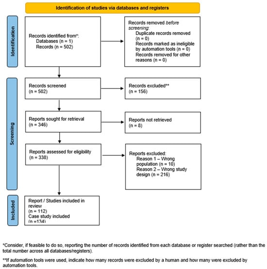
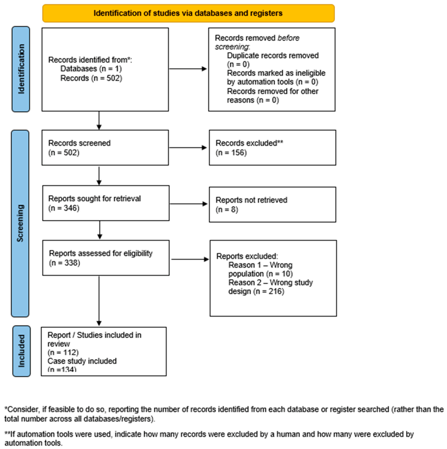
Firstly, titles, abstracts, and keywords were screened, resulting in the exclusion of 156 studies. After a full-text review of 346 studies, 112 articles were included, and 8 were not retrieved. Figure 1 illustrates the article selection process. The database of the 112 selected research is available in Table S2. Among the 112 papers, 134 case studies were assessed for content analysis; some publications depicted several case studies, with different applications of tools in different locations. A publication was counted as containing more than one case when it described applications that differed in location and in application, each with its own context, data, and results. To illustrate, Rodríguez et al. (2009) [23] applied GIS to two case studies in Spain, the Ebro Delta and the Catalan coast, each with its own data and findings, so we coded it as two case studies. Selected publications and their case studies are listed in the supplementary material. The coding framework and ambiguous records were discussed with the co-authors.
Figure 1.
PRISMA 2020 flow diagram. The diagram illustrates the study selection process, including identification, screening, and final inclusion of studies, following PRISMA 2020 guidelines [22].
2.2. Content Analysis Framework
Content analysis was applied to the 134 case studies to identify trends. The coding framework used for this analysis is presented in Table S3. Descriptive statistical methods were then employed to synthesize the findings, which are reported as frequencies of occurrence, relative to the total number of case studies in the sample (n = 134).
Each case study was coded against a structured framework (Table S3) comprising the following thematic dimensions:
Geographical context: The location of each case study was recorded at national and Mediterranean levels.
Coastal issues: The rationale of each ICZM project was characterized by identifying the coastal issues explicitly addressed: pollution (marine and land-based), coastal development, biodiversity loss, climate change, flood, overfishing, erosion, social, over-tourism, conflict between users, and protection. Multiple coastal issues could be attributed to a single case study.
Integration approach: The type of integration pursued in each case study was classified against the nine facets defined by Ernoul (2010) [11]: vertical, horizontal, systemic, functional, spatial, political, disciplinary, planning, and temporal. Multiple facets could be assigned to a single case study where applicable.
Human activities: Human activities identified within each case study were recorded, including tourism, fishing (commercial and non-commercial), industry, recreational activities, agriculture, aquaculture, and transport activities. Multiple human activities could be attributed to a single case study.
Methodology: The methods applied in each case study were categorized into five groups: (a) spatial data analysis, encompassing Geographic Information Systems (GISs) and remote sensing techniques; (b) indicator-based methods (e.g., DPSIR/DAPSI(W)R(M) frameworks, SWOT analysis, and local environmental sustainability indicators); (c) numerical and process-based modelling; (d) Decision Support Systems (DSS); and (e) other methods. Multiple methods could be attributed to a single case study.
Stakeholder involvement: The degree of stakeholder participation was assessed following a ladder of participation framework, distinguishing four levels of engagement: (1) no participation mentioned (stakeholder participation was not reported in the reviewed study); (2) informing (one-way communication from researchers or managers to stakeholders); (3) consultation (stakeholders solicited for their views, without decision-making authority); and (4) active participation [24].
2.3. Data Analysis
Descriptive statistical methods were employed to synthesize the findings, reported as frequencies of occurrence relative to the total number of case studies (n = 134).
3. Results
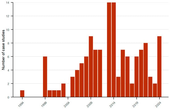
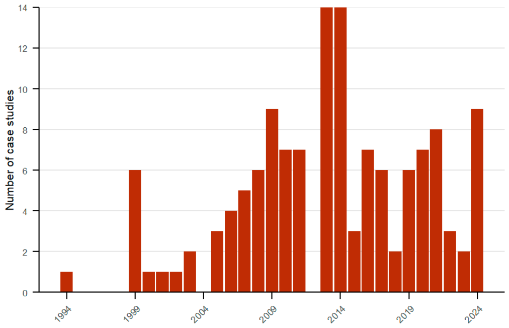
The database contains 134 case studies from 112 publications (database available in the Table S2). The case- median is 2013.5, and the peak extends from 2013 to 2014; each contains 14 cases (Figure 2).
Figure 2.
Timeline of the case studies publication. Distribution of the 134 case studies per publication year.
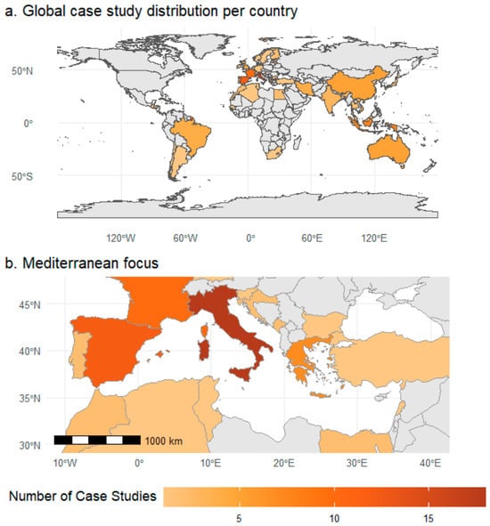
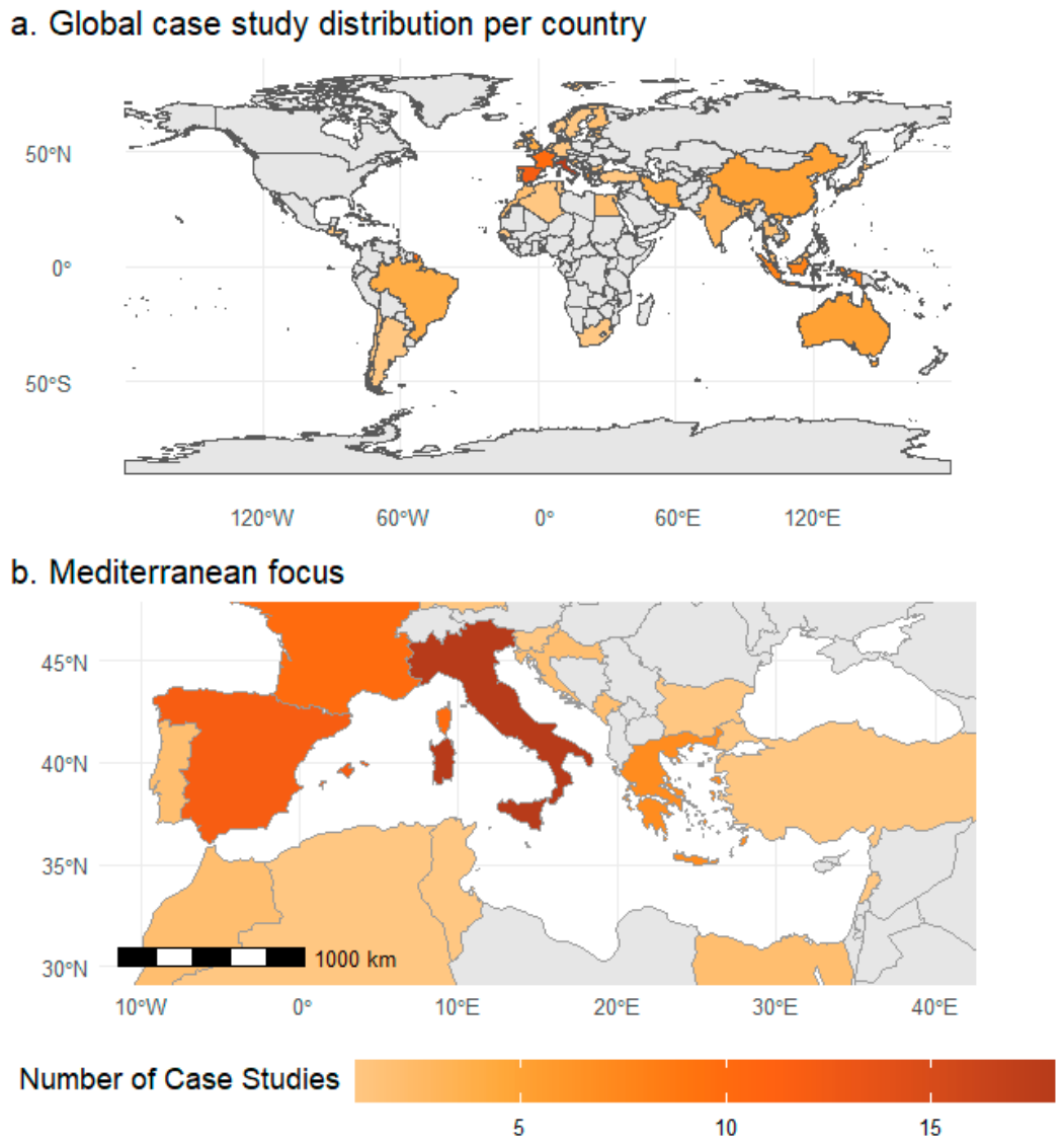
The spatial distribution of ICZM case studies displays the number of case studies per country (Figure 3). Two case studies, presenting a study area overlapping several countries, are being removed from the country distribution analysis. Fifty five case studies are located along the Mediterranean (41%). European Mediterranean countries are a spatial cluster for ICZM application; 74 case studies are based in Europe, with 18 case studies located in Italy, 12 in Spain, 10 in France and 7 in Greece. Figure 3b represents the total number of case studies nationally, with a focus on the Mediterranean Region.
Figure 3.
Spatial distribution of 132 case-study records included in the country-level map. Global distribution (a); Mediterranean focus (b).
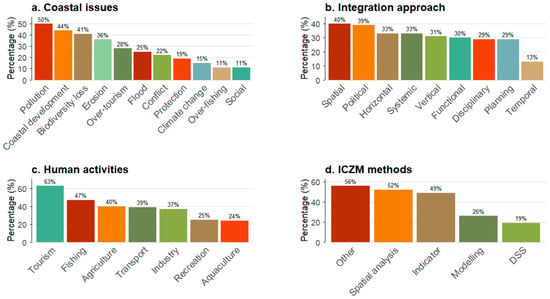
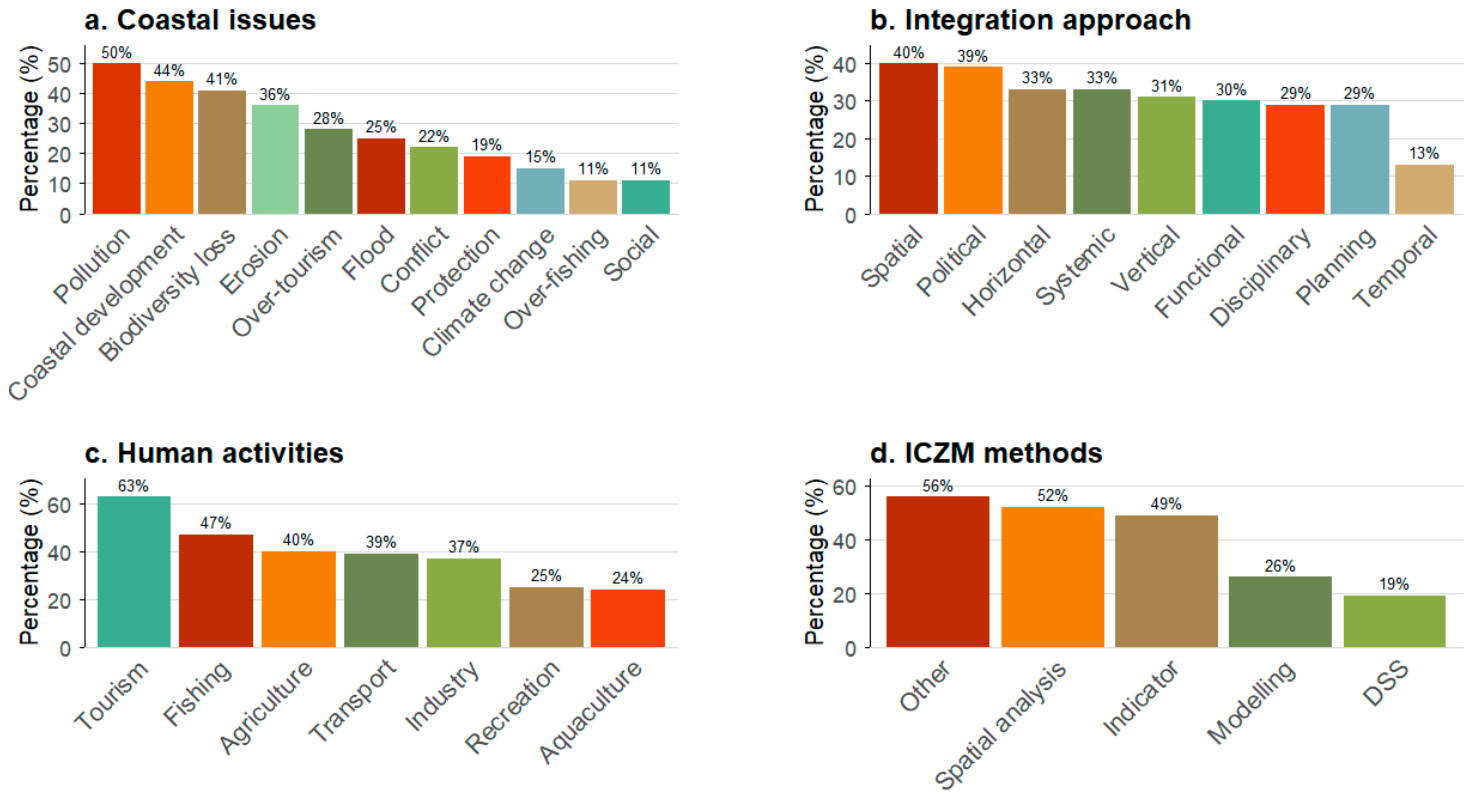
Each case study can identify several “coastal issues”, follow different integration approaches and use a combination of methods. The ICZM case studies addressing “coastal issues” (Figure 4a) include 67 classified as “Pollution” and 59 as “Coastal development”, while only 20 are classified as “Climate Change”. The different research approaches are spread between the nine “integration facets” (Figure 4b), with 53 case studies following a spatial perspective and only 18 a temporal one. The assessment of identified human activities (Figure 4c) highlights the tourism industry (84 mentioned), and 63 case studies identified fishing efforts (for commercial and non-commercial purposes). Regarding applied methods (Figure 4d), 70 case studies used spatial data analysis, and 65 indicator-based methods.
Figure 4.
Proportional distribution of ICZM case studies—coastal issues (a), integration facets (b), human activities (c), and ICZM methods (d) (n = 134).
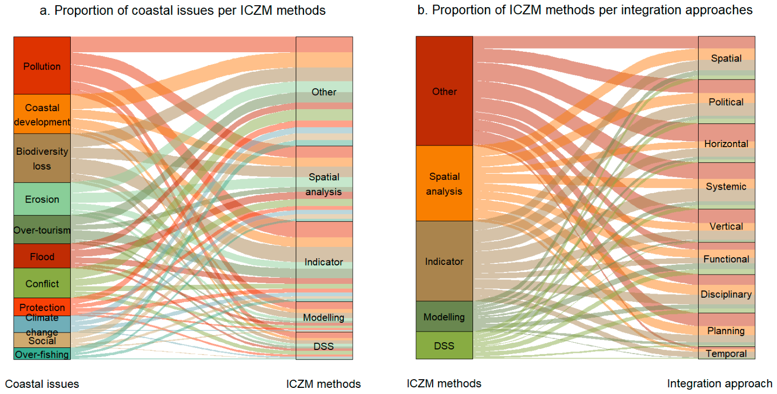
The co-occurrence of ICZM methods with the identified “coastal issues” and with the “integration” approaches was explored descriptively using alluvial graphs (Figure 5).
Figure 5.
Descriptive co-occurrence of ICZM methods (n = 134). Alluvial graphs representing the proportion of coastal issues per ICZM methods (a), and the proportion of ICZM methods per integration approaches (b). The width of a flow between two categories corresponds to the number of case studies identified in both categories.
The assessment of the level of stakeholders’ involvement within case studies indicates that stakeholder participation was not reported in 50 of the 134 cases, stakeholders were consulted in 40 cases, a higher level of participation was reported in 33 cases and stakeholders were informed in 11 cases (Figure 6).
Figure 6.
Proportion of case studies by participatory approach (n = 134). Classification follows the ladder of participation, from non-mention of inclusion, to informing, consulting and active participation.
4. Discussion
4.1. Plurality of ICZM Case Studies
This research reflects the plurality of ICZM case studies, the diversity of coastal issues addressed, different coastal activities, the palette of methodologies used, and their theoretical approaches. ICZM applications use combinations of methods, and there is no consensus on the utilization of a single universal tool [25]. The “integration” assessment, based on the framework extracted from Ernoul (2010) [11], shows that spatial (40%) and political (39%) integration were most frequently addressed, while temporal integration was least frequent (13%). The remaining types were reported in 29–33% of cases, which reflects the diverse understanding of “integration” in ICZM case studies.
The rationale of ICZM projects referred to the assessment or identification of “coastal issues”. Coastal environmental quality, for both terrestrial and marine areas, is affected by pollution, as identified in 50% of the studies reviewed. Marine quality faces pressure from both maritime and land-based pollution sources. In the gulf of Honduras case study, Caviedes et al. (2022) [26] identified pollution as a major threat, with land-based activities leading to agricultural runoff, while maritime activities and port operations deteriorate marine water quality and impact fisheries, aquaculture, and tourism sectors. Coastal development characterized by urbanization and land-cover change is among the most frequently assessed coastal issues (present in 44% of case studies). Yu et al. (2021) [27] explored coastal development through reclamation intensity, to evaluate the extent and trends of urban growth and land-use change within the coastal zone. Biodiversity loss is recognized as one of the crossed planetary boundaries [28] and emerges as the third major concern, identified in 41% of case studies. Larid (2015) [29] conducted a project on the management of the coastal wetland of Réghaia, Algeria, focused on the protection and conservation of the Ramsar site, threatened by an increase in intense human presence.
In this analysis, the European Mediterranean is identified as the main region of ICZM applications. The timeline analysis illustrates a first period of publications from the nineties reaching the peak in 2013–2014. This is explained by the EU support for ICZM development, publishing “Communication from the Commission to the Council and European Parliament on Integrated Coastal Zone Management: A Strategy for Europe” in 2000 [30]. Additionally, the ICZM Protocol of the Barcelona Convention, adopted in 2008, is the first legally binding instrument specifically dedicated to the sustainable management of coastal zones in the Mediterranean region [31]. The Mediterranean Basin is widely recognized as a region highly vulnerable to accelerating climate and environmental change. Beyond climate warming, the region faces multiple and interacting pressures, including shifts in land and sea use, agricultural intensification, urban expansion, rising pollution levels, and ongoing biodiversity decline. In marine systems, ocean warming combined with overfishing may lead to the local extinction of more than 20% of currently exploited fish and marine invertebrate species by 2050 [32].
ICZM applications use a palette of methodologies to address the uniqueness of each coastal case study:
- Spatial data analysis encompasses Geographic Information Systems (GISs) and remote sensing techniques as traditional methods for data collection in ICZM applications (52%). Rodríguez et al. (2009) [23] presented three GIS applications for assessing coastal hazards, shoreline evolution and sand dune evolution. Gourmelon et al. (2014) [33] utilized GIS to map human activities in the Bay of Brest, France. Elnabwy et al. (2020) [34] proposed a method for monitoring the shoreline behavior, based on satellite image analysis. Saad et al. (2022) [35] used a “digital elevation model” to monitor beach profiles for assessing erosion and accretion. Yu et al. (2021) [27] identified coastal reclamation factors through satellite images. Kratzer et al. (2014) [36] applied the ocean color remote sensing tool to assess eutrophication.
- Indicator-based system methods (49%) allow for a holistic understanding of the coastal context. Caviedes et al. (2022) [26] adapted the DPSR Drivers-Pressures-State-Response framework to Drivers–Activities–Pressures–State Changes–Impacts (on Welfare)–Responses (as Measures), DAPSI(W)R(M). Milanés Batista et al. (2020) [37] used the local indicators of environmental sustainability framework, and Sumarmi et al. (2024) [38] used SWOT (Strengths, Weaknesses, Opportunities, and Threats) analysis. Cantasano and Pellicone (2014) [39] applied the Function Analysis based on a system of indicators to determine the environmental quality of the coastal system.
- Modelling methods (26%) are also diverse: Grey et al. (2014) [40] applied a Soil and Water Assessment Tool (SWAT) model, and Oliveira et al. (2014) [41] applied a forecast modelling system based on an interactive WebGIS observatory platform. Guimarães et al. (2014) [42] utilized an Economic Base Model (EBM) to evaluate the economic impact of coastal policies. Morteza et al. (2016) [43] developed an evaluation model based on the analytic network process and a ranking technique to identify ideal tourist site selection.
- Decision-Support Systems (DSS) are described as models providing a user-friendly interface, usually combine different methods. Tan et al. (2018) [44] applied the DSS approach based on system dynamics modelling; Marotta et al. (2011) [45] developed a DSS based on satellite images and indices. Hansen and Fuglsang (2014) [46] combined indicators and land-use modelling for its DSS application.
4.2. Thematic Gaps Identified
Despite the recognition of stakeholder involvement as fundamental for the science–policy–practice junction within the ICZM process, 37% of ICZM applications did not mention any stakeholder involvement. To classify the different levels of “participation”, this study followed the “stakeholder participation ladder” [24]. Information is considered as one-way information flow, from “expert” to “stakeholders”, for consultation; stakeholders provided information within the ICZM process. ICZM applications generally followed consultation (30%) or active participation (25%). Milanés Batista et al. (2020) [37] presented active participation that included the local community within the full stage of the program (preparation, diagnosis, assessment proposal, and implementation), through workshops, various meetings, and focus groups; similarly, Barragán Muñoz et al. (2020) [47] involved stakeholders from the diagnosis to the proposal phase.
Diverse approaches are used to assess stakeholders’ perceptions, views, values and opinions, combining traditional ICZM tools with stakeholder involvement. Participatory mapping is an example of stakeholder engagement applied with spatial data analysis. Hietala et al. (2021) [48] created an online participatory GIS survey in three case studies, using ArcGis and Maptionnaire. The public (residents and visitors) could identify places and describe their views and values of different sites, with reference to coordinated data, and could comment and modify an ICZM draft. This project resulted in an ICZM plan built on perceptions of stakeholders. In parallel with the indicator-based model, Sumarmi et al. (2024) [38] used the SWOT framework to carry out in-depth interviews to determine management strategies and potential development. Niavis et al. (2019) [49] performed a statement ranking through semi-structured interviews in two case studies. Locals involved in waterfront activities evaluated their city waterfront, resulting in the identification of impacts of the proposed ICZM process. Wongthong and Harvey (2014) [50] combined questionnaires and in-depth interviews to propose a combination of the ICZM framework with a community-oriented approach and “self-regulation” and affirmed the difficulty of transferring the accepted ICZM framework within local contexts; they concluded that context is important for selecting or adapting appropriate management strategies.
The multiple climate change impacts on coastal systems are well documented in the literature: global warming leading to water scarcity, rising sea levels and greater storm intensity leading to increased coastal flood risks, shoreline retreat, increasing sea surface temperatures, and ocean acidification [51,52]. These pressures affect biodiversity, compromise ecosystem functioning, and alter the ecosystem services upon which human well-being depends [53]. Despite the recognition of the necessity to integrate climate change-related consequences into ICZM [12], climate change was explicitly identified as a coastal issue in only 20 of the 134 cases reviewed (15%). However, this does not necessarily reflect the extent to which climate-change adaptation was considered in ICZM practice.
Fishing activity was present in 63 of the 134 case studies (47.0%), yet overexploitation of marine resources was identified as a coastal issue in only 15 case studies (11.2%). It does not show how well fisheries management is integrated into them, which we did not assess directly. However, fisheries governance and ICZM have historically evolved separately. Chapter 17th of the Agenda 21 (1992) distinguished “the integrated coastal management” and “the conservation of marine living resources” as complementary programs, leading to the negotiation and adoption of the UN Fish Stocks Agreement, differentiating fisheries management from integrated coastal management [54]. Although the fishery sector is affecting coasts, especially “socio-ecological” coastal dynamics, and a “holistic” approach to coastal management is needed, fisheries management and its governmental structures remain distinct from coastal management ones [2,55]. In the case of over-fishing or destructive habitat fishing techniques, marine protected areas can serve as a tool to implement fisheries management into ICZM through place-based applications [56]. For instance, Nickerson-Tietze (2000) [57] proposed training fishers in alternative livelihoods, such as ecotourism guides, to decrease fishing pressure in the Pulau Payar marine park (Malaysia), as an ICZM management strategy using the Spatial Area Management approach.
4.3. Fuzzy Cognitive Mapping as a Potential Method for ICZM Applications
Based on this review, we propose the use of FCM methods for ICZM applications, to facilitate further research in participatory ICZM applications, especially to achieve “integration”.
Participatory modelling offers a promising approach for addressing complex environmental challenges, as it enables diverse stakeholders to collaboratively build system models that bring together their knowledge, values, and priorities in planning processes. These processes can strengthen local ownership of management strategies, draw on multiple forms of expertise, and support a transition from top–down governance toward more inclusive approaches aligned with community perspectives [58].
FCM is a mental representation of a system. This qualitative model is composed of key variables and the causal links that connect them [59]. You can refer to Figure 2, “Example of Fuzzy Cognitive Mapping”, of the scoping review (Mourhir, 2021 [60]) for a graphical representation of the method [60]. Its graphic representation is composed of nodes, which correspond to concepts, and arrows, which indicate causal relationships between them [16]. Variables may refer to measurable physical elements or more abstract, aggregated concepts. An individual (or a group) constructing the map identifies variables and then specifies causal relationships between them, indicating both direction (using arrows) and relative strength [59]. FCM can be seen as a “mental landscape” of the creator’s knowledge and perceptions of a system, in a graphic representation [61]. Cognitive maps can be developed not only by experts but also by local community members, who often possess detailed ecological knowledge that is valuable for the development of socio-ecological model [59].
This method is used to predict changes of concepts within a system, as they represent causality in dynamic systems. They answer “what if” questions: what happens to the system if some of its components change. As this approach relies on exploring comparable types of system change, it is a suitable method to explore the resilience of SES [62]. This makes it possible to simulate the consequences of alternative policy choices on SES and perform scenario analyses that simulate how different management strategies or development pathways may lead to varying outcomes within the broader system [58,63]. FCMs have been widely applied to explore resilience, socio-ecological systems, and scenario analysis [60,62,63].
FCM bridges the knowledge gap between science, policy and practices [64] as stakeholders can actively contribute to the co-production of decision-support models [58]. Integrated assessment frameworks such as FCMs are commonly employed to address the challenges of complex environmental issues and to support policy-makers in decision-making processes [60], making them well-adapted tools for the implementation of ICZM projects. Nevertheless, the method also presents certain limitations, such as spatial representation, as discussed by (Mourhir, 2021 [60]).
5. Conclusions
Following PRISMA guidelines, this SLR examined the application of ICZM through published case studies. This study provides a database of the selected ICZM case studies in Table S2. This analysis discussed certain patterns emerging from the reviewed literature: the involvement of stakeholders, the consideration of climate-change impacts, and fisheries management within ICZM. This research recommends the exploration of the application of Fuzzy Cognitive Mapping (FCM) to ICZM.
Supplementary Materials
The following supporting information can be downloaded at https://www.mdpi.com/article/10.3390/su182111092/s1, PRISMA 2020 Checklist, Data codebook and Annex.
Author Contributions
Conceptualization, I.V. and G.T.; methodology, I.V.; validation, I.V., G.D.K., S.M. and G.T.; formal analysis, I.V.; data curation, I.V.; writing—original draft preparation, I.V.; writing—review and editing, G.D.K., G.T. and S.M.; visualization, supervision, G.D.K., G.T. and S.M.; project administration, G.D.K.; and funding acquisition, G.D.K. All authors have read and agreed to the published version of the manuscript.
Funding
The European Union’s Horizon Europe research and innovation program under the Marie Skłodowska-Curie Actions Doctoral Network MEDiverSEAty (Grant Agreement No. 101119700).
Institutional Review Board Statement
Not applicable.
Informed Consent Statement
Not applicable.
Data Availability Statement
No new data were created or analyzed in this study. Data sharing is not applicable.
Conflicts of Interest
The authors declare no conflicts of interest. The funders had no role in the design of the study; in the collection, analyses, or interpretation of data; in the writing of the manuscript; or in the decision to publish the results.
Abbreviations
The following abbreviations are used in this manuscript:
| ICZM | Integrated Coastal Zone Management |
| SLR | Systematic Literature Review |
| FCM | Fuzzy Cognitive Mapping |
References
- Le Gentil, E.; Mongruel, R. A Systematic Review of Socio-Economic Assessments in Support of Coastal Zone Management (1992–2011). J. Environ. Manag. 2015, 149, 85–96. [Google Scholar] [CrossRef] [Scilit] [PubMed]
- Sorensen, J.C.; Mc Creary, S.T. Institutional Arrangements for Managing Coastal Resources and Environments; National Park Service, US Department of the Interior: Washington, DC, USA, 1989. [Google Scholar]
- Clark, J.R. Integrated Management of Coastal Zones; FAO Fisheries Technical Paper; FAO: Rome, Italy, 1992. [Google Scholar]
- Le Tissier, M. Unravelling the Relationship between Ecosystem-Based Management, Integrated Coastal Zone Management and Marine Spatial Planning. In Ecosystem-Based Management, Ecosystem Services and Aquatic Biodiversity: Theory, Tools and Applications; O’Higgins, T.G., Lago, M., DeWitt, T.H., Eds.; Springer International Publishing: Cham, Switzerland, 2020; pp. 403–413. ISBN 978-3-030-45843-0. [Google Scholar]
- Müller, S. Integrated Coastal Zone Management: A Sustainable Approach to Protect and Develop Global Coastlines. J. Coast. Zone Manag. 2025, 28, 682. [Google Scholar]
- United Nations. Agenda 21. In Proceedings of the Programme of Action for Sustainable Development, Rio de Janeiro, Brazil, 3–14 June 1992. [Google Scholar]
- UNESCO. Adopted Resolutions of the Intergovernmental Oceanographic Commission IOC of UNESCO. Nineteenth Session of the Assembly; UNESCO: Paris, France, 1997. [Google Scholar]
- Coccossis, H. Integrated Coastal Area and River Basin Management: ICARM; United Nations Environment Programme Water Branch (UNEP)—Priority Actions Programme RegionaI Activity Centre (PAP/RAC): Split, Croatia, 1997. [Google Scholar]
- Nobre, A. Scientific Approaches to Address Challenges in Coastal Management. Mar. Ecol. Prog. Ser. 2011, 434, 279–289. [Google Scholar] [CrossRef] [Scilit]
- Walsh, C. Integration of Expertise or Collaborative Practice?: Coastal Management and Climate Adaptation at the Wadden Sea. Ocean Coast. Manag. 2019, 167, 78–86. [Google Scholar] [CrossRef] [Scilit]
- Ernoul, L. Combining Process and Output Indicators to Evaluate Participation and Sustainability in Integrated Coastal Zone Management Projects. Ocean Coast. Manag. 2010, 53, 711–716. [Google Scholar] [CrossRef] [Scilit]
- Vellinga, P.; Klein, R.J.T. Climate Change, Sea Level Rise and Integrated Coastal Zone Management: An IPCC Approach. Ocean Coast. Manag. 1993, 21, 245–268. [Google Scholar] [CrossRef] [Scilit]
- Coffey, B.; O’Toole, K. Exploring the Role of Science in Coastal and Ocean Management. In Science, Information, and Policy Interface for Effective Coastal and Ocean Management; Taylor & Francis: Abingdon, UK, 2014; p. 28. [Google Scholar]
- McFadden, L. Governing Coastal Spaces: The Case of Disappearing Science in Integrated Coastal Zone Management. Coast. Manag. 2007, 35, 429–443. [Google Scholar] [CrossRef] [Scilit]
- Dale, P.; Sporne, I.; Knight, J.; Sheaves, M.; Eslami-Andergoli, L.; Dwyer, P. A Conceptual Model to Improve Links between Science, Policy and Practice in Coastal Management. Mar. Policy 2019, 103, 42–49. [Google Scholar] [CrossRef] [Scilit]
- Van Kouwen, F.; Dieperink, C.; Schot, P.P.; Wassen, M.J. Interactive Problem Structuring with ICZM Stakeholders. SSRN Electron. J. 2007. [Google Scholar] [CrossRef] [Scilit][Green Version]
- Van Kouwen, F.; Dieperink, C.; Schot, P.; Wassen, M. Applicability of Decision Support Systems for Integrated Coastal Zone Management. Coast. Manag. 2007, 36, 19–34. [Google Scholar] [CrossRef] [Scilit]
- GESAMP. The Contributions of Science to the Integrated Coastal Management; FAO: Rome, Italy, 1996. [Google Scholar]
- Jiang, L.; Yang, T.; Wang, X.; Yu, J.; Liu, J.; Zhang, K. Research on Integrated Coastal Zone Management from Past to the Future: A Bibliometric Analysis. Front. Mar. Sci. 2023, 10, 1201811. [Google Scholar] [CrossRef] [Scilit]
- Meltzer, E. International Review of Integrated Coastal Zone Management: Potential Application to the East and West Coasts of Canada; Department of Fisheries and Oceans: Ottawa, ON, Canada, 1998. [Google Scholar]
- Eger, S.L.; de Loë, R.C.; Pittman, J.; Epstein, G.; Courtenay, S.C. A Systematic Review of Integrated Coastal and Marine Management Progress Reveals Core Governance Characteristics for Successful Implementation. Mar. Policy 2021, 132, 104688. [Google Scholar] [CrossRef] [Scilit]
- Page, M.J.; McKenzie, J.E.; Bossuyt, P.M.; Boutron, I.; Hoffmann, T.C.; Mulrow, C.D.; Shamseer, L.; Tetzlaff, J.M.; Akl, E.A.; Brennan, S.E.; et al. The PRISMA 2020 Statement: An Updated Guideline for Reporting Systematic Reviews. Syst. Rev. 2021, 10, 89. [Google Scholar] [CrossRef] [Scilit] [PubMed]
- Rodríguez, I.; Montoya, I.; Sánchez, M.J.; Carreño, F. Geographic Information Systems Applied to Integrated Coastal Zone Management. Geomorphology 2009, 107, 100–105. [Google Scholar] [CrossRef] [Scilit]
- Dworak, T.; Altvater, S.; Schmidt, S.; Vancauwenbergh, S.; Zamparutti, T. Technical Paper on Public Participation and Marine and Coastal Policies. 2014. Available online: https://circabc.europa.eu/sd/a/3c56efaf-7e4e-4545-8462-9ec8825bc63c/Technical%20paper%20on%20PP_%20MSP_03_02_2015_CLEAN%20-%20formatted.pdf (accessed on 27 October 2026).
- Portman, M.E.; Esteves, L.S.; Le, X.Q.; Khan, A.Z. Improving Integration for Integrated Coastal Zone Management: An Eight Country Study. Sci. Total Environ. 2012, 439, 194–201. [Google Scholar] [CrossRef] [Scilit] [PubMed]
- Caviedes, V.; Arenas-Granados, P.; Barragán-Muñoz, J.M. Integrated Coastal Zone Management on a Transnational Area: The Gulf of Honduras. Mar. Policy 2022, 136, 104931. [Google Scholar] [CrossRef] [Scilit]
- Yu, G.; Liao, Y.; Liao, Y.; Zhao, W.; Chen, Q.; Kou, J.; Liu, X. Research on Integrated Coastal Zone Management Based on Remote Sensing: A Case Study of Guangxi Beibu Gulf. Reg. Stud. Mar. Sci. 2021, 44, 101710. [Google Scholar] [CrossRef] [Scilit]
- Rockström, J.; Steffen, W.; Noone, K.; Persson, Å.; Chapin, F.S.; Lambin, E.; Lenton, T.M.; Scheffer, M.; Folke, C.; Schellnhuber, H.J.; et al. Planetary Boundaries: Exploring the Safe Operating Space for Humanity. Ecol. Soc. 2009, 14, 32. [Google Scholar] [CrossRef] [Scilit]
- Larid, M. L’apport du retour d’expérience au processus de gestion intégrée des zones côtières. Méditerranée Rev. Géographique Pays Méditerranéens J. Mediterr. Geogr. 2015, 141–152. [Google Scholar] [CrossRef] [Scilit]
- COM. Communication from the Commission to the Council and the European Parliament on ICZM: A Strategy for Europe; Commission of the European Communities: Brussels, Belgium, 2000. [Google Scholar]
- UNEP/MAP/PAP. Protocol on the Integrated Coastal Zone Management in the Mediterranean; Priority Actions Programme, Mediterranean Action Plan, United Nations Environment Programme: Split, Croatia, 2008. [Google Scholar]
- MedECC. Climate and Environmental Change in the Mediterranean Basin—Current Situation and Risks for the Future. First Mediterranean Assessment Report; Union for the Mediterranean, Plan Bleu, UNEP/MAP: Marseille, France, 2020. [Google Scholar]
- Gourmelon, F.; Le Guyader, D.; Fontenelle, G. A Dynamic GIS as an Efficient Tool for Integrated Coastal Zone Management. ISPRS Int. J. Geo-Inf. 2014, 3, 391–407. [Google Scholar] [CrossRef] [Scilit]
- Elnabwy, M.T.; Elbeltagi, E.; El Banna, M.M.; Elshikh, M.M.Y.; Motawa, I.; Kaloop, M.R. An Approach Based on Landsat Images for Shoreline Monitoring to Support Integrated Coastal Management—A Case Study, Ezbet Elborg, Nile Delta, Egypt. ISPRS Int. J. Geo-Inf. 2020, 9, 199. [Google Scholar] [CrossRef] [Scilit]
- Saad, R.; Kallas, A.; Gerard, J.A.; Gerard, P. Importance of Beach Evaluation for Integrated Coastal Zone Management A Case Study of Tyre Southern Lebanon. Bull. Société R. Sci. Liège 2022, 91. [Google Scholar] [CrossRef] [Scilit]
- Kratzer, S.; Therese Harvey, E.; Philipson, P. The Use of Ocean Color Remote Sensing in Integrated Coastal Zone Management—A Case Study from Himmerfjärden, Sweden. Mar. Policy 2014, 43, 29–39. [Google Scholar] [CrossRef] [Scilit]
- Milanés Batista, C.; Planas, J.A.; Pelot, R.; Núñez, J.R. A New Methodology Incorporating Public Participation within Cuba’s ICZM Program. Ocean Coast. Manag. 2020, 186, 105101. [Google Scholar] [CrossRef] [Scilit]
- Sumarmi; Irawan, L.Y.; Arinta, D.; Suprianto, A.; Kurniawati, E.; Hidajat, H.G.; Marlina; Fahim, N.B.A.; Arif, M.; Sholeha, A.W.; et al. Tourism Development Strategy Based on Environmental Services with Integrated Coastal Zone Management (ICZM) to Achieve Sustainable Development Goals (SDGs) in Jolosutro Beach of Blitar Regency Indonesia. Geoj. Tour. Geosites 2024, 55, 1377–1391. [Google Scholar] [CrossRef] [Scilit]
- Cantasano, N.; Pellicone, G. Marine and River Environments: A Pattern of Integrated Coastal Zone Management (ICZM) in Calabria (Southern Italy). Ocean Coast. Manag. 2014, 89, 71–78. [Google Scholar] [CrossRef] [Scilit]
- Grey, O.P.; Webber, D.F.S.G.; Setegn, S.G.; Melesse, A.M. Aplicación de la herramienta de evaluación de suelo y agua (modelo SWAT) en una isla tropical pequeña (Gran Cuenca del Río, Jamaica) como una herramienta en la gestión integral de cuencas y manejo de la zona costera. Rev. Biol. Trop. 2014, 62, 293–305. [Google Scholar] [CrossRef] [Scilit]
- Oliveira, A.; Jesus, G.; Gomes, J.; Rogeiro, J.; Azevedo, A.; Rodrigues, M.; Fortunato, A.; Tomas, L.; Vaz, L.; Oliveira, E.; et al. An Interactive WebGIS Observatory Platform for Enhanced Support of Integrated Coastal Management. J. Coast. Res. 2014, 70, 507–512. [Google Scholar] [CrossRef] [Scilit]
- Guimarães, M.H.; Sousa, C.; Dentinho, T.; Boski, T. Economic Base Model for the Guadiana Estuary, Portugal an Application for Integrated Coastal Zone Management. Mar. Policy 2014, 43, 63–70. [Google Scholar] [CrossRef] [Scilit]
- Morteza, Z.; Reza, F.M.; Seddiq, M.M.; Sharareh, P.; Jamal, G. Selection of the Optimal Tourism Site Using the ANP and Fuzzy TOPSIS in the Framework of Integrated Coastal Zone Management: A Case of Qeshm Island. Ocean Coast. Manag. 2016, 130, 179–187. [Google Scholar] [CrossRef] [Scilit]
- Tan, W.-J.; Yang, C.-F.; Château, P.-A.; Lee, M.-T.; Chang, Y.-C. Integrated Coastal-Zone Management for Sustainable Tourism Using a Decision Support System Based on System Dynamics: A Case Study of Cijin, Kaohsiung, Taiwan. Ocean Coast. Manag. 2018, 153, 131–139. [Google Scholar] [CrossRef] [Scilit]
- Marotta, L.; Ceccaroni, L.; Matteucci, G.; Rossini, P.; Guerzoni, S. A Decision-Support System in ICZM for Protecting the Ecosystems: Integration with the Habitat Directive. J. Coast. Conserv. 2011, 15, 393–405. [Google Scholar] [CrossRef] [Scilit]
- Hansen, H.S.; Fuglsang, M. An Operational Web-Based Indicator System for Integrated Coastal Zone Management. ISPRS Int. J. Geo-Inf. 2014, 3, 326–344. [Google Scholar] [CrossRef] [Scilit]
- Barragán Muñoz, J.M.; García Sanabria, J.; de Andrés García, M. ICZM Strategy for the Socioecological System of the Mar Menor (Spain): Methodological Aspects and Public Participation. In Socio-Ecological Studies in Natural Protected Areas: Linking Community Development and Conservation in Mexico; Ortega-Rubio, A., Ed.; Springer International Publishing: Cham, Switzerland, 2020; pp. 243–272. ISBN 978-3-030-47264-1. [Google Scholar]
- Hietala, R.; Ijäs, A.; Pikner, T.; Kull, A.; Printsmann, A.; Kuusik, M.; Fagerholm, N.; Vihervaara, P.; Nordström, P.; Kostamo, K. Data Integration and Participatory Process in Developing Integrated Coastal Zone Management (ICZM) in the Northern Baltic Sea. J. Coast. Conserv. 2021, 25, 47. [Google Scholar] [CrossRef] [Scilit]
- Niavis, S.; Papatheochari, T.; Coccossis, H. Supporting Stakeholder Analysis within ICZM Process in Small and Medium-Sized Mediterranean Coastal Cities with the Use of Q-Method. Theor. Empir. Res. Urban Manag. 2019, 14, 53–74. [Google Scholar]
- Wongthong, P.; Harvey, N. Integrated Coastal Management and Sustainable Tourism: A Case Study of the Reef-Based SCUBA Dive Industry from Thailand. Ocean Coast. Manag. 2014, 95, 138–146. [Google Scholar] [CrossRef] [Scilit]
- Nicholls, R.J.; Wong, P.P.; Burkett, V.; Codignotto, J.; Hay, J.E.; McLean, R.F.; Ragoonaden, S.; Woodroffe, C.D. Coastal Systems and Low-Lying Areas. In Climate Change 2007: Impacts, Adaptation and Vulnerability. Contribution of Working Group II to the Fourth Assessment Report of the Intergovernmental Panel on Climate Change; Cambridge University Press: Cambridge, UK, 2007. [Google Scholar]
- Gonçalves, S.C. Monitoring and Assessment of Environmental Quality in Coastal Environments. Environments 2022, 9, 25. [Google Scholar] [CrossRef] [Scilit]
- Cooley, S.; Schoeman, D.; Bopp, L.; Donner, S.; Ghebrehiwet, D.Y.; Ito, S.-I.; Kiessling, W.; Martinetto, P.; Ojea, E.; Racault, M.-F.; et al. Oceans and Coastal Ecosystems and Their Services in: Climate Change 2022—Impacts, Adaptation and Vulnerability: Working Group II Contribution to the Sixth Assessment Report of the Intergovernmental Panel on Climate Change, 1st ed.; Cambridge University Press: Cambridge, UK, 2022; ISBN 978-1-009-32584-4. [Google Scholar]
- Hoel, A.H.; VanderZwaag, D. The Global Legal Dimension. In Governance of Marine Fisheries and Biodiversity Conservation; John Wiley & Sons, Ltd.: Hoboken, NJ, USA, 2014; pp. 96–109. ISBN 978-1-118-39260-7. [Google Scholar]
- Nunan, F.; Omondi, M.; Nchimbi, A.; Mangora, M.; Kairo, J.; Shalli, M.; Jiddawi, N. The Silos of Natural Resource Governance: Implications of Sector-Led Coastal Management at the Village Level in Kenya and Zanzibar-Tanzania. Conserv. Soc. 2020, 18, 148. [Google Scholar] [CrossRef] [Scilit]
- Done, T.J.; Reichelt, R.E. Integrated Coastal Zone and Fisheries Ecosystem Management: Generic Goals and Performance Indices. Ecol. Appl. 1998, 8, S110–S118. [Google Scholar] [CrossRef] [Scilit]
- Nickerson-Tietze, D.J. Scientific Characterization and Monitoring: Its Application to Integrated Coastal Management in Malaysia. Ecol. Appl. 2000, 10, 386–396. [Google Scholar] [CrossRef]
- Issac, J.; Newell, R. Integrating Stakeholder Knowledge Through a Participatory Approach and Semi-Quantitative Analysis for Local Watershed Management. Systems 2025, 13, 364. [Google Scholar] [CrossRef] [Scilit]
- Özesmi, U.; Özesmi, S.L. Ecological Models Based on People’s Knowledge: A Multi-Step Fuzzy Cognitive Mapping Approach. Ecol. Model. 2004, 176, 43–64. [Google Scholar] [CrossRef] [Scilit]
- Mourhir, A. Scoping Review of the Potentials of Fuzzy Cognitive Maps as a Modeling Approach for Integrated Environmental Assessment and Management. Environ. Model. Softw. 2021, 135, 104891. [Google Scholar] [CrossRef] [Scilit]
- Horstkotte, T.; Löf, A.; Moen, J. Understanding Adaptation Landscapes: Mapping the Complexity of Decision-Making in Reindeer Herding. Arct. Rev. Law Polit. 2024, 15, 202–230. [Google Scholar] [CrossRef] [Scilit]
- Kok, K. The Potential of Fuzzy Cognitive Maps for Semi-Quantitative Scenario Development, with an Example from Brazil. Glob. Environ. Change 2009, 19, 122–133. [Google Scholar] [CrossRef] [Scilit]
- Carvalho, J.P. On the Semantics and the Use of Fuzzy Cognitive Maps and Dynamic Cognitive Maps in Social Sciences. Fuzzy Sets Syst. 2013, 214, 6–19. [Google Scholar] [CrossRef] [Scilit]
- de Jong, C.E.; Kok, K. Ambiguity in Social Ecological System Understanding: Advancing Modelling of Stakeholder Perceptions of Climate Change Adaptation in Kenya. Environ. Model. Softw. 2021, 141, 105054. [Google Scholar] [CrossRef] [Scilit]



Disclaimer/Publisher’s Note: The statements, opinions and data contained in all publications are solely those of the individual author(s) and contributor(s) and not of MDPI and/or the editor(s). MDPI and/or the editor(s) disclaim responsibility for any injury to people or property resulting from any ideas, methods, instructions or products referred to in the content. |
© 2026 by the authors. Licensee MDPI, Basel, Switzerland. This article is an open access article distributed under the terms and conditions of the Creative Commons Attribution (CC BY) license.