


Abstract
Italy’s transition to river basin district governance within the framework of Directive 2000/60/EC unified institutional responsibilities while leaving existing flood and landslide plans in force. District authorities therefore had to integrate instruments with different knowledge bases, classifications and land-use rules. This article examines the integration of nine Hydrogeological Setting Plans (PAIs) into two coordinated plans for the Central Apennine district (42,275 km2), adopted in final form in May 2026. Document analysis compared classifications, intervention conditions and assessment responsibilities, examining 175 public submissions and 118 first-round regional determinations. Geographic information system analysis quantified current classification correspondences and coverage: approximately 1860 km2 within the fluvial planning framework, including safeguard proposals, and 107,045 landslide phenomena occupying approximately 4970 km2. Initial flood transposition retained inherited boundaries, while landslide classification followed a common type–activity matrix. Regulatory comparisons identified conditional extensions of admissibility alongside more selective urban restructuring rules; the plans also established formal updating procedures. Institutional review connected technical choices with regulatory decisions, producing amendments while leaving some precautionary disagreements unresolved. The framework coordinated inherited knowledge without eliminating differences in detail or completeness. The article offers a procedural and regulatory reference for other authorities facing fragmented planning systems; implementation and risk-reduction outcomes require subsequent evaluation.
1. Introduction
Floods and landslides threaten settlements, infrastructure and economic activities. European assessments identify substantial losses from weather and climate extremes and growing risks to infrastructure, ecosystems and economic security [1,2]. Prevention depends on both knowledge of hazards and decisions governing exposure and vulnerability.
Italy has extensive exposure to diverse flood and landslide processes. The 2025 assessment by the Italian Institute for Environmental Protection and Research (ISPRA) records more than 636,000 landslide phenomena and approximately 69,500 km2 in landslide-hazard or attention areas. High and very high landslide-hazard classes cover 9.5% of the national territory. For flooding, the national mosaic based on 2020 data identifies 6.8 million residents in areas covered by the medium-hazard P2 scenario [3]. These figures establish the relevance of land-use regulation alongside structural risk-reduction measures.
The increase in risk, however, is not driven solely by changes in climate-related phenomena. Urbanization, soil sealing, occupation of flood-prone areas, slope modification, aging infrastructure, and maintenance deficiencies continually alter exposure and vulnerability. Hydrogeological risk must therefore be understood as the product of interactions between natural processes and the ways in which land is developed and transformed.
In this context, land-use planning plays a key preventive role. It can prevent new exposure, preserve the space required for flood conveyance and attenuation, protect slope stability, and govern transformations of the existing built environment. To fulfill this role, however, planning must be supported by reliable knowledge, understandable classifications, consistent rules, and clearly organized responsibilities. The availability of maps alone does not ensure that risk is incorporated into decision-making.
European water policy establishes the river basin district as a coordinating scale through Directives 2000/60/EC and 2007/60/EC [4,5]. In Italy, basin planning under Law No. 183/1989 and the subsequent framework of Hydrogeological Setting Plans (Piani di Assetto Idrogeologico, PAIs) connects hazard identification with binding land-use provisions [6,7,8].
The district-authority reform reorganized institutions without immediately replacing existing planning instruments [8,9,10]. District authorities thus brought together plans developed at basin and sub-basin scales, at different dates and with different classifications, knowledge bases and regulatory approaches. Harmonization required integrating these instruments into a common district framework.
Fragmentation affected knowledge bases, maps, regulatory frameworks, procedures, institutional responsibilities, and updating capacity. It consequently influenced both the conditions governing land transformation and the equitable application of rules to comparable physical conditions. Section 4 reconstructs the dimensions and consequences of this fragmentation.
Flood-risk governance research examines institutional arrangements, strategies and coordination [11,12,13]. Within this field, integrating pre-existing plans that remain legally operative raises a specific question: how can heterogeneous hazard knowledge be connected to common classifications and binding land-use provisions?
Harmonization must address differences in both the underlying evidence and the way it is classified. European research has documented variation in flood-mapping practices and their use in spatial planning [14], while landslide research shows how inventory methods, completeness and mapping quality shape the basis for hazard assessment [15]. These differences are also embedded in established institutions: comparative analysis of Floods Directive implementation found that national flood-risk management traditions sometimes prevailed over harmonization objectives [16]. A common classification therefore requires explicit decisions about how different sources and practices are brought together.
ISPRA’s national mosaics reconcile heterogeneous hazard representations to support national assessments and risk indicators [3,17]. District PAI harmonization addresses a further task: establishing common hazard classifications and associated land-use rules through consultation and formal adoption. This requires linking technical classification choices to institutional decisions about their regulatory consequences. By providing a common district framework at the source of the national mosaics, the adopted plans may also facilitate their subsequent compilation.
The 2023 national Policy Guidance identified district PAIs and harmonized safeguards and provisions as priorities [18]. The district draft plans pursued this objective alongside public access to territorial information, supported by the district web-based geographic information system (WebGIS) [19,20,21].
This article analyzes the development of the district Flood and Landslide PAIs prepared by the Central Apennine River Basin District Authority (AUBAC). The district covers 42,275 km2, includes parts of seven regions, 22 provinces and 901 municipalities, and has approximately 8.6 million inhabitants [21]. Its inherited planning framework comprised nine PAIs. Draft plans were adopted on 31 July 2025 through Resolutions Nos. 57 and 58 of the Permanent Institutional Conference (CIP) [19,20]. Following consultation and regional institutional review, the two plans were adopted in final form on 26 May 2026 through Resolutions Nos. 67 and 68 [22,23]. The case permits examination of two hazard-specific harmonization methods within the same institutional setting.
Figure 1 situates the district geographically and illustrates the initial institutional fragmentation.
Figure 1.
The Central Apennine River Basin District and the nine pre-existing PAIs. Source: prepared by the author using AUBAC WebGIS and planning information [24]. PAI boundaries and thematic layers: AUBAC. Basemap credits: Esri, USGS, TomTom, Garmin, FAO and NOAA.
This study addresses three research questions (RQ1–RQ3): (RQ1) How were heterogeneous inherited classifications harmonized while preserving the underlying knowledge and its provenance? (RQ2) How were the resulting classifications connected to common rules, procedures and responsibilities? (RQ3) What changes, disagreements and limits are demonstrated by the documentary record at adoption?
This study makes four connected contributions. Empirically, it documents how classifications and land-use provisions changed and how institutional review led to amendments, clarifications or retained disagreement. Methodologically, it combines document analysis and geographic information system (GIS) comparisons to trace the relationships between source information, district classifications and regulatory provisions. Theoretically, it explains how a common classification can accommodate differences in the underlying evidence and applicable rules while leaving some disagreements over precaution unresolved. In practical terms, it documents how plan preparation was organized through classification harmonization, progressive regulatory drafting, coordinated technical and institutional review, and differentiated handling of observations. Other planning authorities can draw on these procedural choices and regulatory solutions, adapting them to their own data, legal frameworks and administrative capacities. Six analytical functions organize the reconstruction of this process and make its decision points explicit.
Section 2 defines the analytical framework; Section 3 explains the methods; Section 4 and Section 5 reconstruct the inherited system and harmonization operations; Section 6 presents the findings; Section 7 discusses their implications, transferability and limitations; and Section 8 concludes with this study’s contributions and directions for future research.
2. Theoretical Framework
Harmonizing hazard plans requires decisions about which information to retain, how to classify it and what land-use rules to associate with each class. The theoretical framework examines how these decisions are connected and how they can be reconsidered when objections or new evidence arise.
Three bodies of research inform this analysis. Classification and knowledge-infrastructure research helps explain how information from different sources is organized into shared categories while retaining differences in its origin and meaning. Policy integration research addresses how these categories are connected to land-use provisions, administrative procedures and institutional responsibilities. Adaptive planning research examines how planning arrangements allow decisions to be revisited as knowledge and conditions change.
These perspectives guide the examination of three observable relationships: how the district classifications incorporate inherited knowledge; how those classifications shape the conditions under which land-use interventions are permitted; and how institutional review addresses disagreement and additional evidence. The analytical framework summarized at the end of this section links these relationships to the theoretical concepts and documentary evidence used in the analysis.
2.1. Classification and Regulatory Knowledge
Hazard knowledge is produced and maintained through the work of technical experts, public organizations, information systems and shared standards. Knowledge-infrastructure research examines how these elements operate together [25]. In land-use planning, their relationship matters because the information they produce supports decisions about where and under what conditions development may occur. Research on spatially integrated policy infrastructure provides a basis for examining how this knowledge is connected to planning decisions [26].
Classification is a central part of that connection. It organizes diverse observations into categories that make particular conditions visible and relevant to decisions [27]. When plans use different sources and criteria, establishing a common classification requires choices about which distinctions to retain and how to represent them. Shared categories can then serve as “boundary objects”: common references that different professional and institutional communities use together, even when their interpretations or priorities differ [28]. Agreement to use a category therefore need not imply agreement on all its regulatory consequences.
This study uses the term public regulatory knowledge infrastructure to describe the institutional arrangement connecting documented hazard knowledge to official classifications, land-use provisions and formal procedures for revision. The concept focuses on the decisions linking these elements: how source information supports an official class, how provisions determine the interventions admissible within that class, and how objections or new evidence can lead to reconsideration. It allows integration to be examined through these relationships, including where differences or disagreements persist.
Three expectations guide the analysis. First, a common classification may bring together information from different sources without making the underlying evidence equally detailed or reliable. Second, a category may remain a shared reference even when its precautionary adequacy is contested. Third, the rules applicable within a class may be differentiated without changing the class itself. Classification crosswalks, adopted provisions and documented responses to observations are used to examine these expectations in Section 6 and Section 7.
2.2. Integration, Land Use and Revision
Policy integration concerns how institutions coordinate their understanding of a problem, the actors involved and the instruments used to address it [29]. In basin planning, this coordination must connect territories that are physically linked by water flows and slope processes but governed by different administrations [30,31]. A district framework can establish common classification criteria and regulatory provisions, while regional and local authorities contribute territorial knowledge and exercise their respective responsibilities. Integration therefore depends on how these roles work together and how decisions account for effects beyond administrative boundaries.
Land-use planning gives this coordination practical consequences by determining where development may occur and under what conditions existing settlements may be transformed. Research on spatial planning and flood-risk management examines this connection [26,32,33], while landslide-zoning guidelines relate hazard assessment to land-use planning [34]. Italian research on dispersed settlement patterns highlights the importance of these decisions in territories where buildings and infrastructure extend across large areas [35,36]. New development, transformation of existing buildings and mitigation works raise different planning questions: preventing additional exposure, adapting existing settlements and reducing existing hazards or vulnerabilities. These different purposes help explain why a common hazard classification must be connected to provisions tailored to the intervention concerned.
These decisions also depend on how institutions assess uncertain or incomplete knowledge [37]. An inventory entry, a detailed study and an officially classified area may provide different kinds of evidence and have different regulatory status. The analysis therefore examines how planning procedures handle missing attributes and additional studies, including the conditions under which new information can support a change in classification or applicable provisions.
Adaptive planning extends this question over time by examining how decisions can be revised as knowledge and conditions change [38,39,40]. For PAIs, this involves procedures for assessing additional evidence, updating official maps and amending rules. This study examines both the revision procedures established by the plans and their use where documented. Recursion refers here to a documented reconsideration of an earlier classification or regulatory choice in response to objections or additional evidence. Formal updating provides a procedure for revising maps or provisions as new knowledge becomes available. Table 1 summarizes this analytical framework.
Table 1.
Analytical framework of the study.
3. Research Design and Methodology
3.1. Research Strategy and Units of Analysis
This study adopts a single-case design, with the Central Apennine district planning process as the case and flood and landslide harmonization as two embedded units of analysis [41]. Comparing the two units within the same institutional setting makes it possible to distinguish hazard-specific choices about source information and classification from shared arrangements for regulatory drafting, institutional review and formal updating.
The case was selected because it brings together nine pre-existing PAIs across seven regions and documents their integration into two coordinated district plans. It provides evidence of how different technical methods were developed within a common planning process and how classification and regulatory choices were examined through consultation and institutional review.
The comparison is used to develop analytical propositions about how harmonization works and to identify procedural choices that other planning authorities can assess and adapt. Their transferability depends on the available knowledge, legal framework and administrative capacity.
3.2. Temporal Scope and Sources
The reconstruction of plan formation covers the period from the Policy Guidance of July 2023 [18] to final adoption on 26 May 2026 [22,23]. Earlier planning documents establish the inherited baseline; the draft General Reports document the initial district proposals [19,20], while the final reports and NTA establish the adopted framework [42,43]. A complementary spatial analysis uses datasets obtained on 3 October 2026 to describe hazard extent and examine correspondences between the preceding and district planning systems.
The primary research technique is document analysis: a systematic examination and interpretation of sources that considers their provenance, purpose and function [44]. The corpus comprises planning reports, maps, appendices, resolutions, procedural records and Technical Implementation Provisions (Norme Tecniche di Attuazione, NTA). Table 2 summarizes the source groups and their role in the analysis.
Table 2.
Sources and their functions in the analysis.
Sources were selected for their relevance to the preparation, amendment and adoption of the two PAIs and to comparison with the preceding plans. For each document, the issuing body, date, procedural status, subject matter and analytical function were recorded. Intermediate versions were included where they documented changes between draft preparation, consultation and final adoption. Institutional communication materials provided context; technical findings were based on the underlying planning documents and records.
The regional corpus comprises twelve reports containing regional observations and AUBAC’s reasoned responses, transmitted to the Regions on 9 March 2026 [52]. These were organized into an analytical matrix comprising 118 issue-level determinations. For descriptive aggregation, mixed determinations containing both acceptable and partially acceptable components were classified as partially accepted; the original wording was preserved in the internal verification record. The analytical matrix compiled for this study forms part of the internal verification record and is not published. Public consultation reports count submissions, whereas the analytical matrix records issue-level determinations; these units are therefore reported separately.
The spatial analysis uses AUBAC district landslide, fluvial flood and marine flood datasets exported on 3 October 2026, together with preceding-plan maps and safeguard layers retrieved from the public WebGIS on the same date. For flooding, spatial intersections compare the preceding and district categories; the hydraulic extract includes updates under Decrees Nos. 139 and 140/2026. For landslides, retained source-plan and source-class attributes allow comparison with district classifications on the mapped inventory features.
The landslide extract incorporates updates through the July 2026 Operational Conference. Its acquisition date is distinguished from this update cutoff and from the publication status of the live WebGIS. The spatial comparison describes the datasets available at the common acquisition date, with differences in update coverage and unmatched areas recorded explicitly. Initial harmonization is reconstructed through the documented classification rules and adoption-stage sources, while current spatial correspondences may also reflect subsequent studies and updates.
3.3. Analytical Procedure
The analysis combined documentary comparison, reconstruction of selected review cases and spatial calculations. These established how classifications and provisions changed, how observations were assessed, and the territorial extent of current source-to-district relationships. Table 3 specifies the information extracted and the operation performed for each component.
Table 3.
Information extracted and operations performed in the analysis.
Documentary information was organized in a comparison matrix by source/version, hazard domain, analytical dimension and issue–response chain. Each entry retained the relevant article, page or response item. Identical labels were not assumed to represent equivalent physical conditions across plans, and hazard and risk classifications were kept distinct.
An ex post comparison applied source criteria and the district matrix to the same documented combinations of quiescent and inactive slides. Source assignments came from the Marche and Tiber schemes reconstructed in Appendix 1 to the Landslide General Report [24]; district assignments came from Annex 1 to the Landslide NTA [43]. Holding type and activity constant isolated differences between assignment rules. This comparison was conducted for the study and was not presented as an option appraisal undertaken during plan preparation.
Regulatory comparisons used the intervention type as the common basis for reading selected previous and adopted provisions. The analysis distinguished changes in class labels from changes in admissibility, assessment requirements and competent authorities, taking account of territorial and transitional qualifications. It examined adopted rules rather than project authorizations or realized transformations.
Process-tracing literature informed the reconstruction of sequences and documentary links [60]. Selected cases linked observations from regional response reports [52] and public reports [50,51] to institutional assessments and relevant adopted texts. Cases examined amendment with a retained class, unresolved precautionary disagreement and conditional incorporation of knowledge. A source-extraction correction documented in Appendix 1 to the Landslide General Report was considered separately as evidence of source verification [24]. A favorable response was not counted as an implemented amendment unless the change was verified in the adopted text; correspondence between an observation and final wording did not establish exclusive causal attribution.
The 118 regional determinations were aggregated using the categories in Section 3.2. Selected cases explain mechanisms rather than estimate their frequency. Public-consultation reports and regional response documents are identified separately in the case descriptions and references. The author checked reported documentary entries against source texts and numerical results against the analytical datasets. No inter-coder reliability statistic was calculated because coding was undertaken by a single researcher.
Spatial calculations used ETRS89/UTM zone 33N (EPSG:25833). Polygons were dissolved within each class to calculate class coverage and across classes to calculate total coverage. Class areas may overlap and are not necessarily additive; each total union counts overlapping territory once. Fluvial flooding, landslides and marine flooding were analyzed separately. Counts refer to inventory features; coverage percentages use the approximately 42,275 km2 district as the denominator. District-scale areas are generally rounded to the nearest 10 km2, and smaller areas and correspondences to the nearest km2.
For landslides, features were grouped by recorded source plan, source code and district class, with counts and union areas calculated for each group. For flooding, geometric unions of preceding-plan categories were intersected with district categories, keeping approved mapping and safeguard overlays distinct. The Misa and Pescara updates were already included in the district adoption layer. These calculations describe current correspondences, which may include subsequent updates; documentary rules establish initial harmonization. Appendix A reports the complete aggregated provenance and spatial correspondence matrices and summarizes the extraction procedures; geometry checks and detailed extraction records are retained in the internal verification record.
Previous comparisons of landslide inventories identify mapping methods, scale and source information as factors affecting comparability [61,62]. These considerations informed interpretation of recorded correspondences rather than calculation of their areas.
The reconstruction distinguished six functions according to the decision addressed and the link between input and output. Inventory organized source information into a provenance record; classification correspondence related source attributes to district categories; regulatory design connected categories to admissibility provisions; validation linked proposals and objections to institutional assessments; transition defined the relationship between preceding and adopted instruments; and updating established formal routes for incorporating additional evidence. Inventory and classification were reconstructed from the planning reports and Appendix 1 to the Landslide General Report [24,42,43]; regulatory design, transition and updating from the NTA [42,43]; and validation from regional response reports and public-consultation reports [50,51,52]. These functions may overlap and are not separate chronological stages.
Findings were organized by research question: classification and spatial correspondences for RQ1; provisions, procedures and responsibilities for RQ2; and review responses for RQ3. Comparison with the theoretical expectations in Section 2 informed the analytical propositions in Section 7.1. Transferability was examined by separating source-comparison methods and organizational arrangements from Italian statutory requirements and hazard-specific criteria. Other Italian planning pathways provided context rather than an independent test of effectiveness. Figure 2 summarizes the analytical workflow.
Figure 2.
Research workflow from source and version identification to interpretation. Solid arrows indicate the main analytical sequence; dashed arrows indicate analytical and source-verification iterations. The embedded comparison includes GIS coverage calculations and source-to-district class correspondence checks.
The spatial calculations were implemented in custom Python scripts using Shapely and verified using Python 3.12.14 and Shapely 2.2.0 (GEOS 3.14.1).
During the preparation and revision of this manuscript, the author used ChatGPT (OpenAI; GPT-5 series for initial preparation and GPT-6 Astra for revision) and Claude (Anthropic; Opus 5.5) primarily to support English-language refinement and improve the clarity and organization of the author’s text, with additional assistance in figure preparation and the writing and checking of GIS analysis scripts. The author critically reviewed, revised or discarded AI suggestions, verified all retained content, and takes full responsibility for the published article.
3.4. Outputs, Outcomes, and Impacts
The analysis distinguishes planning outputs, implementation outcomes and risk impacts. Outputs include the adopted classifications, regulatory provisions and procedures, together with the mapped areas to which the compared provisions relate. Outcomes concern how these provisions are applied through assessments, authorizations and actual land-use changes. Impacts concern changes in exposure, vulnerability and risk. This study documents planning outputs and their territorial extent; outcomes and impacts require evidence of subsequent implementation.
The territorial extent of the regulatory comparison is identified by linking documented classification rules and current spatial correspondences to the preceding and adopted provisions, taking account of applicable territorial and transitional regimes. Where an adopted provision allows reconstruction subject to a favorable compatibility assessment, that assessment is a condition for authorizing individual projects within the area governed by the provision. The area measure therefore captures the territorial scope of this conditional pathway, irrespective of whether applications have already been submitted or approved. It does not count eligible buildings or completed transformations. Current spatial correspondences are interpreted separately from the initial harmonization where subsequent studies have revised hazard mapping.
3.5. Source Verification
Reported interpretations were checked against primary documents and successive versions, distinguishing proposed changes, institutional responses and adopted provisions. Contextual knowledge of the planning process (see Conflicts of Interest) was used to support reconstruction but was distinguished from the documentary and spatial evidence supporting the findings. The analysis reports non-accepted proposals and unresolved disagreements alongside documented amendments and differences in regulatory treatment.
4. The Initial System: Nine PAIs and Fragmented Planning
At the start of district plan preparation, AUBAC managed a planning system developed over more than two decades by former national, interregional and regional basin authorities. It comprised nine PAIs: Abruzzo–Sangro, Fiora, Lazio Regional Basins, Liri–Garigliano, Marecchia–Conca, Marche Regional Basins, Ombrone, Tiber and Tronto [42,43]. Each brought its own knowledge base, maps, regulatory provisions and procedures, reflecting different planning histories and territorial contexts.
Integrating these instruments required coordination across seven regions and multiple levels of administration. The institutional setting combines AUBAC’s technical bodies, the Operational Conference, the Permanent Institutional Conference and regional programmatic conferences under Article 68 of Legislative Decree No. 152/2006 [8]. The latter involve provinces, municipalities and basin authorities in examining the draft plans and their relationship to territorial planning. These forums supported the examination of technical choices and their regulatory implications.
The starting point was therefore an extensive but heterogeneous planning system. Harmonization required identifying which knowledge could be retained, how existing classifications could be related to common district categories, and which provisions and updating procedures needed coordination. The following subsections examine these differences and their consequences for planning.
4.1. Knowledge-Base and Cartographic Heterogeneity
The pre-existing landslide plans drew on regional inventories, field surveys, geological and geotechnical studies, and monitoring activities conducted at different times and using different methods. Their maps represented different aspects of instability, including hazard, risk and susceptibility, sometimes within combined schemes. The phenomena and features recorded also varied: alongside landslides, they could include badlands, scarps, cavities, sinkholes, avalanches, point features and attention areas. Terminology for activity states differed between plans [43].
These differences extended to the meaning of mapped boundaries and classes. Polygons could delineate an existing instability, its potential evolution, a surrounding buffer or an area combining several phenomena. Mapping scales and levels of detail also varied [43]. Hazard scales reached five levels in some landslide plans. In certain plans, polygon symbology represented risk, while hazard was recorded separately in accompanying lists or labels [24,43]. Comparing these maps therefore required examining both what each polygon represented and how its attributes had been classified.
For flooding, heterogeneity concerned the scenarios and return periods used to delineate areas, the terminology of flood zones and the relationship between hazard and risk. The plans used categories such as A, B and C; A1–A2 and B1–B2; E1–E4; and P.I.2–P.I.4, while some represented a single floodable zone. These schemes were not directly comparable, and not all followed the three probability scenarios used in the Floods Directive [42]. Establishing district correspondences therefore required relating each source category to its underlying scenario and definition.
4.2. Regulatory, Procedural, and Institutional Heterogeneity
Differences between the pre-existing PAIs extended from mapping to the rules governing land use. Their NTA specified different protection thresholds, permitted and prohibited interventions, study requirements, assessment procedures and competent authorities. Similar interventions could follow different administrative pathways. Exceptions for existing settlements, residual plots, agricultural areas, infrastructure and works without feasible alternative locations also varied.
These differences reflected the institutional arrangements of the former national, interregional and regional basin authorities. Each plan allocated responsibilities and established procedures for incorporating new studies, monitoring results and cartographic changes. At district scale, these inherited arrangements provided no common procedure for assessing additional knowledge and incorporating it into updated maps and provisions.
Table 4 summarizes these dimensions and their implications for comparing plans and coordinating decisions.
Table 4.
Dimensions of fragmentation among the pre-existing PAIs.
The inherited system therefore posed two linked problems: establishing correspondences between classifications based on different sources and criteria, and coordinating the provisions and procedures associated with them. Comparable physical conditions could receive different regulatory treatment under different plans. Classification harmonization provided a basis for comparison, while regulatory coordination required separate decisions about admissibility, assessment and responsibilities. The following section reconstructs how these tasks were addressed.
5. Construction of the District Framework
Preparation of the district PAIs connected three tasks: reviewing the inherited knowledge and classifications, developing common regulatory provisions, and examining both through technical and institutional review. Flood and landslide specialists used different classification methods within a shared coordination process. Section 6 presents the resulting correspondences, regulatory comparisons and documented responses to observations.
5.1. Organizing Inherited Knowledge into District Classes
The initial review identified the source plans, the phenomena and areas represented, their classification criteria and the supporting information. This established the basis for relating existing categories to district classes while preserving the provenance and level of detail of the source knowledge [24,42,43].
Preparation progressed from harmonizing hazard representations and classes to developing provisions for permitted, conditional and prohibited interventions, followed by coordination of the NTA as a whole. Separate flood and geomorphological groups worked within this common process. The AUBAC–Regions Technical Working Group provided a forum for examining technical choices and their regulatory implications [48].
For flooding, the initial transposition retained inherited flood-zone boundaries and assigned them to the common P1–P3 system. Correspondences were established by examining the definition and mapped meaning of each source category. The district return-period ranges are up to 50 years for P3, over 50 to 200 years for P2, and over 200 to 500 years for P1 [42,63]. Because the preceding plans used different thresholds, categories assigned to the same district class could retain differences in their underlying flood scenarios. New delineations based on additional studies were addressed through separate assessment and updating operations.
For landslides, classification used information on phenomenon type and activity state through the common district matrix, with incomplete characterization handled separately. Preparing the district inventory also required data extraction, replacement of some source inventories and corrections documented in Appendix 1 to the Landslide General Report [24,43]. The work therefore combined classification harmonization with the documented integration and revision of the underlying inventories.
These two methods established the classification framework used to develop the district provisions. The flood crosswalk and landslide type–activity matrix are presented in Section 6.1.
5.2. Regulatory Design and Institutional Review
Building on the classification framework, regulatory drafting addressed the conditions for permitted interventions, the studies and assessments required, and the responsibilities of the competent authorities. The provisions also defined the relationship with existing planning instruments and the procedures for subsequent updates [42,43].
Following draft adoption on 31 July 2025, public consultation and regional institutional review examined the proposed classifications and provisions before final adoption on 26 May 2026. The public response reports address 133 flood submissions and 42 landslide submissions, each potentially containing several issues [50,51]. Regional observations were examined through a separate review process, documented in twelve reasoned response reports transmitted on 9 March 2026 [52].
The review addressed proposals to amend regulatory provisions, objections to classification choices and requests supported by additional territorial information. Depending on their subject and supporting evidence, issues were addressed through amendments, clarifications, retention of the proposed approach or referral to further technical assessment and formal updating. Section 6.3 examines these responses and their relationship to the adopted texts, including cases in which disagreement remained unresolved. Appendix B documents the procedural sequence, the common NTA architecture, the graded review pathways and the distribution of functions among AUBAC, the Regions and municipalities.
5.3. Adoption and Revision Routes
Final adoption was accompanied by safeguard measures limited to the provisions and maps enumerated in CIP Resolutions 67 and 68 [22,23]. Publication of the notices on 4 June 2026 activated those measures; full plan effectiveness remains distinct from this selected safeguard regime [53,54].
The adopted framework provides dedicated technical and participatory procedures for map updates under Flood Article 22 and Landslide Article 20 [42,43]. During the transition, Article 4 of both adoption resolutions retains the preceding-plan procedures for updates initiated before the district plans enter into force, subject to safeguards; their results also update the district maps [22,23]. New evidence therefore requires the applicable formal procedure to change official delineations or classifications. Regulatory amendments follow a distinct procedure.
Separating map updates from amendments to the general provisions combines regulatory continuity with an evolving knowledge base. Maps can be revised through technical assessment, public notice, participation and agreement with the competent Region, without reopening the general regulatory framework each time. Changes in the territorial application of the rules therefore follow formal map revisions, rather than arising automatically from the availability of new data [42,43].
These updating procedures are supported by common technical references for subsequent studies: the hydrological–hydraulic guidance in Annex 2 to the Flood NTA and the landslide classification and survey requirements in Annexes 1 and 5 to the Landslide NTA [42,43].
6. Results
The results examine how inherited information was organized into common hazard classes, how those classes were connected to land-use provisions, and how institutional review addressed proposed changes and disagreements. Section 6.1, Section 6.2 and Section 6.3 answer the three research questions; Section 6.4 quantifies the territorial extent of the mapped categories and their current spatial correspondences.
6.1. RQ1: Classification Harmonization and Retained Knowledge Differences
The two district plans established common hazard classifications through different operations. Flood harmonization related existing zones to the district P1–P3 system while retaining their delineations in the initial transposition. Landslide harmonization assigned P1–P4 classes using a common matrix of phenomenon type and activity state. In both domains, the resulting categories brought together information whose sources, detail and classification criteria had previously differed [24,42,43].
For flooding, Table 5 shows how each source category was related to a district class according to its definition and underlying scenario. The correspondence was not always one-to-one. In Abruzzo–Sangro, for example, the former P4 and P3 categories, associated with 50–100-year scenarios in the source framework, were both assigned to district P3 [42]. This merged two planning categories while retaining the mapped flood extent. Because source thresholds differed between plans, the common district label did not imply that all contributing areas had been delineated using the same hydraulic scenario.
Table 5.
Correspondence between the hazard classes of the pre-existing instruments and the classes of the District Flood PAI for river and coastal flooding.
The crosswalk also reveals differences in scenario coverage. For much of the Marche river network, the available mapping represented only the 200-year floodable zone, assigned to district P2. Additional studies had introduced other scenarios in specific areas: the Misa mapping included 50- and 500-year scenarios, while low-probability scenarios were also available in parts of Abruzzo–Sangro [42]. Harmonization organized this uneven coverage within a common framework, leaving gaps where the corresponding scenarios had not been mapped.
Figure 3 shows the cartographic application of this operation in the PS6 area of the Tiber basin. The paired maps retain the illustrated delineations while expressing the inherited categories through district classes. Table 5 and Figure 3 therefore document complementary aspects of the same result: the correspondence rule and its application to existing planning maps.
Figure 3.
PS6 in the Tiber basin: (a) inherited planning zones; (b) their transposition into district flood classes P3, P2 and P1 on the retained delineations. Panel (a) retains the source-layer legend; zone A is absent from the illustrated extent, which contains zones AA, B and C. The figure illustrates classificatory transposition based on inherited planning knowledge, not new hazard modeling, a GIS before/after analysis or a measured spatial effect of harmonization. Source: prepared by the author based on AUBAC [19,42]. Basemap: Regione Lazio, Carta Tecnica Regionale (CTR), licensed under CC BY 4.0 (https://creativecommons.org/licenses/by/4.0/), displayed through the AUBAC WebGIS and overlaid with AUBAC planning layers.
For landslides, the common matrix combines twelve phenomenon types with three harmonized activity states—active, quiescent and inactive—to assign hazard classes (Table 6). Classification depends on these descriptive attributes rather than on the previous class label alone. The codes and terminology in Table 6 reproduce Annex 1 to the adopted Landslide NTA [24,43].
Table 6.
Harmonized landslide hazard matrix adopted in the district PAI.
The applied comparison in Table 7 shows what this choice means for two documented combinations. Under the source schemes described in Appendix 1 to the Landslide General Report, quiescent slides were assigned to P2 in Marche and P3 in the Tiber plan; inactive slides were assigned to P1 and P2, respectively [24] (pp. 31, 34). Applying the district matrix assigns P2 to quiescent slides and P1 to inactive slides in both cases. Retaining the source criteria would preserve the different assignments; applying the common matrix removes that difference.
Table 7.
Applied comparison of source retention and district classification for documented slide types.
In these examples, convergence follows the Marche assignments rather than retaining the higher Tiber categories. Appendix 1 to the Landslide General Report [24] describes calibration of the harmonization threshold with reference to less restrictive legacy schemes, while the final NTA establish harmonized minimum protection levels and allow more restrictive territorial provisions under the applicable conditions [24,43]. The comparison thus identifies both the gain in classificatory consistency and the choice underlying it: standardization did not preserve every higher source assignment. Its precautionary adequacy remained open to institutional scrutiny, as the disagreement examined in Section 6.3 demonstrates.
The integration is also visible across adjoining planning jurisdictions. Figure 4 compares the former Tiber, Marche and Tronto representations with district hazard mapping in the same area. The Tiber representation combined hazard classes, landslide inventory information and avalanche risk. Official Marche and Tronto sheets used risk classes for polygon symbology, recording hazard separately in the accompanying event lists and in H0–H4 polygon labels, respectively. The district map represents these territories through a common hazard-classification framework, with the former PAI boundaries retained in both panels to make the comparison legible. This is integration of the underlying information into a shared representation, rather than a direct conversion of risk labels into hazard classes.
Figure 4.
Landslide-related representations across the adjoining territories of the former Tiber, Marche and Tronto PAIs: (a) legacy PAI layers, including hazard, risk and inventory information; (b) district Landslide PAI hazard classification. Both panels show the same geographical extent and retain the former Tiber and Tronto PAI boundaries as reference lines. Colors and patterns in panel (a) represent different variables and are interpreted through their respective legends; panel (b) uses the common district hazard classes P1–P4. In panel (a), Marche and Tronto landslide areas are shown by risk class, as in the official PAI map sheets; their hazard levels (P1–P4 and H0–H4) were recorded in event lists and polygon labels, respectively, rather than through polygon fill colors. Source: AUBAC WebGIS, accessed 4 October 2026; composition by the author. Official map sheets consulted: Marche PAI, Risk Map Sheet RI 70d (update approved by DPCM of 14 March 2022); Tronto PAI, Sheet 10/20, Landslide and Floodable Area Map (update by Secretarial Decree No. 263/2023).
The district framework also distinguishes classified hazards from information requiring further characterization. Insufficiently characterized phenomena and potentially hazardous geological or geomorphological elements were retained separately from definitive P1–P4 assignments, with the relevant verification or updating requirements [43]. Risk classes R1–R4 were derived separately by combining hazard with potential damage, preserving the distinction between the characteristics of the phenomenon and its consequences for exposed elements [24] (p. 46).
The current technical inventory contains 107,045 mapped landslide phenomena and covers approximately 4970 km2, or 11.8% of the district (Table 8). P2 accounts for 70,176 phenomena, or 65.6% of the total, and approximately 2990 km2. P3 contains 27,276 phenomena across approximately 1300 km2, while P4 contains 4271 across approximately 180 km2. The predominance of P2 is consistent with the assignment of several quiescent landslide types to that class under the district matrix. Table 8 describes the inventory composition, while Table 6 and Table 7 explain the relevant assignment criteria.
Table 8.
Landslide inventory by hazard class and approximate share of district territory, based on the extract obtained on 3 October 2026.
The principal result is a common classification framework in which source differences remain traceable. Flood correspondence preserves the relationship to inherited zones and scenarios; landslide classification relates recorded types and activity states to shared assignment rules. The resulting maps can be read through common district categories while retaining information about differences in source coverage, characterization and detail.
6.2. RQ2: Regulatory Consequences of Harmonization
The adopted district framework connects common hazard classes to provisions governing interventions, assessment procedures and institutional responsibilities. The comparison identifies changes in both directions: some provisions broaden conditional admissibility, while others establish more selective conditions. Their consequences depend on the preceding rules, the intervention considered and the applicable territorial regime.
Article 6 of both sets of NTA regulates the relationship with urban and spatial planning according to a principle of hierarchical coordination. The binding force and precedence of landscape plans for landscape protection remain unaffected under Legislative Decree No. 42/2004 [64]. In the event of conflict, the PAI takes precedence within its remit over socioeconomic development plans and programs and over instruments governing spatial organization and land use. More restrictive regional and local provisions remain applicable, provided that they are consistent with and do not conflict with the district framework [42,43].
The common provisions connect admissibility to prevention of additional hazard and risk, preservation of flood conveyance and attenuation, protection of slope stability and control of new exposure [42,43]. Review requirements vary with both hazard class and intervention type. The Flood NTA distinguish interventions requiring an AUBAC opinion and assessment by the competent hydraulic authority, assessment by that authority alone, or no specific PAI opinion. The Landslide NTA distinguish requirements for AUBAC and regional opinions, separately or both, and cases requiring no PAI opinion. These exemptions do not remove other applicable technical and authorization requirements. Under Landslide Article 8, a Technical Verification (“Verifica Tecnica”) supports assessment of compatibility; only specified interventions meeting the conditions of paragraph 2 may instead use a certified statement of no aggravation (“Attestazione asseverata di non aggravamento”) [42,43].
Table 9 examines these changes through selected provisions from the Marche regional-basin PAI [45], Tiber PAI [46] and Abruzzo–Sangro Flood Defence Sub-Plan (PSDA) [47], following the classification correspondences in Table 5 and the adopted district provisions [42]. The cases illustrate conditional expansion of admissibility and greater selectivity. They compare adopted provisions; the distinction between adoption and legal effectiveness is set out in Section 5.3.
Table 9.
Selected comparisons of inherited and adopted flood-planning provisions.
The Marche case is informative because source terminology, cartographic correspondence and regulatory treatment diverge. Article 8 of the previous NTA associated a single high–very high hazard level with the delineated floodable areas, while distinguishing four risk levels. Article 9(1)(c) admitted statutory building renovation without volume increases, apart from specified adjustments; Article 9(2) required technical compatibility verification [45]. The district crosswalk places the inherited 200-year zone under P2, but Article 26(4) prescribes the P3 regime for specified morphologically delineated single-zone areas identified by map hatching. Subsequent assessment need not assign those areas to P2: the applicable class must follow the approved assessment and updating procedure [42].
The adopted P3 and P2 provisions both expressly address reconstruction and permit conditional vertical extensions without additional enclosed ground-floor coverage. Their conditions differ: Article 9(7)(c) requires no increase in urban-development load, whereas Article 10(7)(d) allows a conditional increase of up to 15% within the specified reconstruction provision, with unchanged use and the required compatibility findings. This is a load threshold, not an automatic volume bonus.
Both reconstruction provisions require compliance with the hydraulic safety conditions in paragraph 4 of the respective article, including a first-floor elevation above the 200-year flood level plus the prescribed safety margin. P3 reconstruction excludes basement and semi-basement rooms. In P2, their retention or reinstatement is allowed only for existing lawful rooms in reconstruction for seismic improvement or upgrading, with unchanged dimensions, non-residential and non-commercial use, no continuous occupancy, flood protection and no increase in exposure or vulnerability. The Marche comparison thus shows how the opportunities for adapting existing buildings depend on the applicable regime, including the transitional P3 treatment [42].
The Tiber band B case shows a different direction of change. Former Article 29(2)(b) admitted urban restructuring subject to the hydraulic conditions in Article 29(3). District Article 10(1)(d) restricts this category to the cases in Article 10(7)(e). These concern specified pre-existing planning provisions for residual plots in wholly or partly built-up A, B and D zones and facilities of general interest in F zones, supported by studies conforming to Annex 2. Article 6(8) assigns the Regions a separate conditional route for qualifying pre-existing planning provisions, without introducing additional building entitlement [42,46].
The Abruzzo–Sangro merger illustrates why one common class can have different consequences according to provenance. Previous P4 provisions listed demolition without reconstruction and limited repair of damaged buildings; reconstruction was expressly contemplated under conditions in previous P3. Both source categories enter district P3, whose Article 9(7)(c) explicitly provides for conditional reconstruction. The new ordinary provision therefore extends the listed building interventions relative to the previous P4 provision. For former P3, the change concerns conditions rather than first admissibility. Article 20(1)(b) required unchanged volume and shape, with access and the first floor more than 1 m above ground level. District Article 9(7)(c) permits vertical extensions without additional enclosed ground-floor coverage or increased urban-development load. This comparison concerns the reconstruction provision; former Article 20 also contained separate provisions for specified extensions and built-up centers. Site applicability still depends on TI and other relevant restrictions [42,47].
The spatial comparison gives the Abruzzo–Sangro case a measurable territorial extent: approximately 64 km2 of approved preceding-plan P4 mapping correspond to consolidated district P3. This is the area addressed by the comparison between the previous P4 reconstruction provision and the adopted district pathway, independently of whether individual projects have been proposed or authorized.
Regulatory treatment also depends on territorial qualifications within the mapped hazard classes. The Integral Protection Zone (TI) lies within mapped P1–P3 areas; its Article 8 regime does not apply in urban zones A and B, where the hazard-band provisions and applicable hydraulic checks remain applicable [42].
Marginal areas link differentiated regulatory treatment to flood intensity within the common probability-based classes. Article 7(9) identifies portions of P3 and P2 where water depth and flow velocity fall within Domain 1 (“Ambito 1”) of the Annex 2 depth–velocity graph, evaluated for the 50-year and 200-year scenarios, respectively. Delineation also considers the expected hydraulic dynamics and the surrounding morphological and territorial context. Within formally delineated P3 marginal areas, the P2 provisions apply to the regulation of interventions; within P2 marginal areas, specified new construction and expansion may be admitted under the conditions established by the NTA [42]. These provisions retain the mapped hazard class while differentiating regulatory treatment according to more detailed hydraulic information.
For inherited mapping, Article 7(9) provides for progressive delineation where detailed hydraulic information consistent with Annex 2 is available. Until the first formal cartographic identification, the specific provisions dependent on marginal-area status are not operative. Delineation follows Article 22(5); the graph cannot independently establish marginal-area status through an individual project assessment [42].
The preventive framework also extends beyond mapped hazard areas. Flood Article 16 applies hydraulic invariance to territorial transformations wherever located, requiring that peak stormwater discharge to receiving water bodies does not increase. Article 17 includes integrated ecosystem and biodiversity restoration among mitigation measures. The Landslide NTA identify limiting land take and promoting the renaturation of urban and periurban soils as objectives for prevention and vulnerability reduction [42,43].
The principal result is that common hazard classes support a coordinated regulatory framework with differentiated conditions for intervention. Compared with the preceding plans, the adopted provisions introduce both conditional extensions of admissibility and more selective requirements. The applicable treatment depends on the intervention, territorial qualifications and transitional provisions, so the direction of regulatory change cannot be inferred from the class label alone.
6.3. RQ3: Amendment, Disagreement and Knowledge Incorporation
The documentary record shows that review produced different responses according to the issue examined: regulatory provisions were revised, classification choices were retained despite objections, and additional evidence was directed to technical assessment and formal updating. These differences reveal how institutional coordination addressed proposals without requiring agreement on every classification or regulatory consequence.
This study’s analytical matrix classifies 59 of the 118 first-round regional determinations as accepted, 46 as partially accepted and 13 as not accepted, based on AUBAC’s reasoned responses [52]. The distribution demonstrates differentiated assessment, including explicit non-acceptance. These classifications record the response to each issue; amendments are identified separately through comparison with the adopted documents.
A public example concerns the joint professional submission under Protocol No. 14460/2025 of 20 November 2025. The objection to merging A1 and A2 into P3 led to a response that retained the common class while reporting changes to definitions, differentiated admissibility and the role of detailed studies (item 87(1), p. 106). The response also identified methodological clarifications concerning the proponent’s study and compatibility verification, the hydraulic authority’s evaluation and the definition of marginal areas (item 87(4), p. 108). However, the proposal to assess interventions within Domain 2 (“Ambito 2”) of the depth–velocity graph as admissible subject to mitigation and compensation was not accepted (item 87(5), p. 109) [50].
The adopted Annex 2 corroborates the distinction of technical roles at p. 70 and the criteria for marginal-area delineation at p. 76 [42]. Read together, the response report and adopted provisions document reconsideration of the relationship between a retained class and its regulatory treatment. They do not establish that this submission alone determined the final wording.
A different regulatory response concerned interventions already provided for by existing planning instruments. The territorial issue was reformulated as a general district-wide provision in Article 6(8), rather than retained as an individual territorial exception [42,43,48]. In this case, review changed the scope of the response by expressing it through a provision applicable across the district.
Classification review also exposed disagreement that remained unresolved. A regional administration questioned the assignment of certain quiescent landslide types to P2 as insufficiently precautionary. The common matrix was retained, while its role as a minimum district threshold and the possibility of more restrictive territorial provisions were clarified [52]. Retaining the shared classification therefore did not establish technical consensus on its precautionary adequacy.
Additional knowledge followed another route. Regional historical flood-extent records were recognized as relevant inputs, but their incorporation into official hazard maps remained subject to district technical standards and the formal update procedure [52]. Recognition of their evidential value thus provided a basis for further assessment without automatically modifying the maps.
Separately, Appendix 1 to the Landslide General Report records the correction of an erroneous extraction from the former Lazio regional PAI database before final adoption [24] (§9, pp. 37–38). This demonstrates verification and correction of source-data handling. The record does not identify who detected the error or associate its detection with a specific participation channel.
The principal finding is that validation connected different issues to different decisions. A shared class could be retained while its regulatory treatment was revised or its precautionary adequacy remained contested; a territorial concern could be addressed through a general provision; and additional knowledge could be recognized while requiring further assessment before incorporation. Coordination therefore combined amendment, retained disagreement and formal routes for further investigation.
6.4. Territorial Coverage, Updating and Evidence Boundaries
The spatial analysis establishes the territorial scale of the framework examined in Section 6.1, Section 6.2 and Section 6.3 and quantifies current correspondences between inherited and district categories. The technical landslide inventory covers approximately 12% of the district (Table 8). Consolidated fluvial mapping covers approximately 1830 km2, or 4.3%; safeguard proposals add approximately 27 km2 outside that footprint, bringing the combined coverage to approximately 1860 km2, or 4.4%. Marine flood mapping covers approximately 35 km2, or 0.08% (Table 10). The three hazard domains are reported separately.
Table 10.
Approximate current flood-hazard extent and share of district territory, 3 October 2026.
Within the consolidated fluvial map, approximately 820 km2 are classified as P3, 560 km2 as P2 and 250 km2 as P1. These mapped classes include territorial qualifications relevant to their regulatory treatment. Approximately 200 km2 of mapped P2 correspond to inherited floodable areas in the Marche regional basins subject to transitional P3 provisions under Article 26(4), pending determination of their effective hazard levels. A further 210 km2 comprise reclamation attention areas, where Article 14(2) applies P2 provisions pending hazard definition, without prejudice to more precautionary sectoral provisions [42]. The smaller extent of mapped P1 partly reflects the uneven availability of inherited low-probability scenarios, including 500-year scenarios.
The correspondence analysis shows how categories from the preceding plans contribute to the district framework (Table 11). In Abruzzo–Sangro, approximately 64 km2 of former P4 and 32 km2 of former P3 correspond to district P3. In the Lazio regional basins, approximately 66 km2 of A1 and 9 km2 of A2 correspond to P3, while approximately 74 km2 of B1 and B2 correspond to P2. These examples quantify the extent to which different source categories are represented within a common district class. Other entries document the retention of source distinctions through corresponding district categories.
Table 11.
Principal source-to-district classification correspondences and their approximate territorial extent in the current mapping.
Current mapping also contains intersections that depart from the initial crosswalk. Examples include approximately 19 km2 of Tiber principal-network band C intersecting district P2 or P3, 9 km2 of Abruzzo–Sangro P2 intersecting district P3, and 8 km2 of Tiber band B intersecting district P3. These are reported in the complete matrix in Appendix A, Table A2. Because the compared layers incorporate subsequent studies and updates, the intersections establish current spatial relationships; their causes cannot be inferred from the crosswalk alone.
For landslides, the Tiber and Marche examples show district assignments both higher and lower than the hazard classes represented by the recorded source codes. In the Tiber inventory, 36,475 features with source code 3 are assigned to district P2, covering approximately 570 km2; about 96% are recorded as quiescent. This pattern is consistent with the former Tiber scheme assigning P3 to several quiescent landslide types [24]. Features with the same source code also occupy approximately 277 km2 in district P3. In the Marche inventory, 3127 features carrying source code 1 are assigned to district P2, covering approximately 246 km2, while approximately 73 km2 remain in P1. The complete provenance matrix in Appendix A accounts for all 107,045 inventory features.
These landslide correspondences give territorial scale to the differences between source schemes and district assignments. They complement the comparison of classification rules in Section 6.1, while describing the current inventory, including subsequent updates. Their regulatory implications must be read through the associated provisions.
Continued updating explains why the spatial analysis refers to a dated planning framework. New studies pass through proposal, safeguard and approval stages, during which an approved map and a safeguard overlay may coexist. The overlay can introduce additional mapped areas or revised classes before definitive incorporation into the plan. This process progressively revises the knowledge base beyond the initial harmonization of inherited classifications.
The district WebGIS makes the maps available for consultation alongside other spatial information [21]. Its presentation of preceding-plan safeguards and district counterparts also makes the procedural status of updates visible. The platform provides access to these representations, while the formal planning procedures establish changes to official classifications and provisions.
Taken together, the spatial and documentary analyses quantify the territory represented by common classes and identify the areas addressed by the regulatory comparisons. The territorial scope of a conditional reconstruction provision, for example, can be measured independently of whether projects have already been proposed or authorized. The findings therefore establish the extent of the planning framework and selected regulatory changes. Their uptake and consequences—approval rates, completed regeneration, changes in exposure and damage, and administrative performance—require project-level or longitudinal evidence.
7. Discussion
The results show how common classifications, regulatory provisions and institutional review worked together in the preparation of the district plans. This section examines what these relationships imply for the theoretical framework and what other planning authorities can learn from the process. Three propositions emerge from the case, developing the expectations introduced in Section 2.
7.1. Knowledge as a Public Regulatory Infrastructure
The first proposition is that common classification can make inherited information usable within one planning framework while preserving differences in its evidential basis. The Abruzzo–Sangro merger brought categories based on different flood scenarios into district P3, while the Marche crosswalk incorporated mapping with incomplete scenario coverage. In both cases, a common classification was established without recalculating every area through a uniform hydraulic model. These findings connect knowledge-infrastructure and classification research [25,27] to a practical requirement of planning: the sources and criteria underlying a mapped class remain relevant after harmonization. Retaining provenance allows users to distinguish what has been standardized from what still requires further investigation. A common classification established at the planning source may also support subsequent national mosaics, providing a shared institutional reference for statistical aggregation.
The second proposition is that a common category can remain in use while disagreement persists over its adequacy or consequences. The quiescent-landslide case shows this directly: the district P2 assignment was retained despite an objection to its precautionary adequacy. The public A1/A2 case illustrates a related but different response: the common class was retained while its regulatory treatment was reconsidered. These cases explain how classifications can function as boundary objects [28] in regulatory planning. They provide a shared reference through which institutions can coordinate decisions, while allowing debate to continue over the protection afforded by a class or the interventions permitted within it. Adoption therefore establishes a common framework without necessarily resolving the disagreements expressed during its preparation.
The third proposition is that the regulatory use of hazard knowledge depends on institutional decisions connecting evidence, official classification and applicable provisions. Historical flood records could be recognized as relevant evidence without immediately changing official maps. Detailed hydraulic information can support marginal-area delineation, but the associated provisions require a formal map update. In the Marche case, an inherited zone corresponds to mapped P2 while specified areas remain subject to transitional P3 provisions. These examples show why evidence, mapped class and applicable regime must be examined separately. They give concrete expression to the spatial-policy-infrastructure perspective [26]: integration involves establishing how technical information enters official planning and how that planning governs land-use decisions.
Together, these propositions explain the role of a public regulatory knowledge infrastructure. Its contribution lies in connecting information, classifications and provisions through traceable decisions, while retaining the means to examine source differences, address objections and incorporate new evidence. Figure 5 summarizes these relationships and the validation and updating routes documented in Section 5.3 and Section 6.3.
Figure 5.
Analytical propositions derived from the case. Common classification can retain the provenance and differences of inherited knowledge (P1); a common category can remain in use while its precautionary adequacy or regulatory consequences are contested (P2); institutional decisions connect recognition of evidence, official classification and applicable regulatory treatment (P3). Validation can revisit the class-to-rule relationship, while formal updating provides a route for revising maps or provisions. Implementation outcomes lie outside the evidence of the study. Source: prepared by the author.
7.2. Common Thresholds and Precautionary Trade-Offs
Establishing a common classification requires deciding how to handle differences between inherited schemes. Table 7 illustrates the consequences of retaining source assignments or applying the district matrix to the same documented type–activity combinations. Retention preserves the distinction between Marche and Tiber: quiescent slides receive P2 and P3, respectively, while inactive slides receive P1 and P2. The district matrix assigns P2 to quiescent slides and P1 to inactive slides in both territories. Standardization therefore establishes a common explicit rule but does so without retaining the higher Tiber assignments in these examples.
The current inventory gives this issue a substantial territorial dimension. Approximately 570 km2 of Tiber features carrying source code 3 are assigned to district P2, and about 96% of these features are recorded as quiescent (Section 6.4). This correspondence describes the current inventory, including subsequent updates, rather than isolating the effect of initial harmonization. Nevertheless, it shows why the treatment of quiescent phenomena is consequential for the district framework. The objection documented in Section 6.3 concerns the adequacy of the common threshold for precisely this type of classification choice.
The comparison of alternatives is an ex post analytical exercise; it does not establish that both options were formally evaluated during plan preparation. Retaining source assignments would preserve their differences, while applying the district matrix makes assignments consistent for the selected inputs. Reassessing the underlying hazard would address a further question, requiring additional evidence about the phenomena themselves. The comparison thus identifies what the common matrix achieves—consistency of assignment—and the question that remains open: whether its precautionary threshold is adequate across the conditions to which it applies.
The regulatory significance of a lower assignment depends on the provisions associated with the source and district classes. The district matrix establishes common class assignments, while the NTA define minimum protection levels and allow more restrictive territorial provisions under the applicable conditions [24,43]. That possibility does not establish that additional protection applies throughout the areas concerned. Assessing changes in protection therefore requires examining the governing rules alongside the classification, including territorial qualifications and requirements for further investigation.
The flood comparisons illustrate the complementary point that regulatory treatment can change while a common class is retained. In the A1/A2 case, review reconsidered the provisions associated with P3 without abandoning the category. More broadly, Section 6.2 identifies conditional opportunities for adapting existing buildings alongside more selective conditions for urban restructuring. Harmonization consequently involves choices about which transformations to permit and under what conditions, connecting hazard classification to the management of the existing built environment [26,29]. Its precautionary implications must be assessed through those specific choices, rather than inferred from a uniform direction of change across the district. Together, the preventive provisions examined in Section 6.2 connect hazard regulation with runoff management, soil protection and ecosystem restoration in ordinary territorial transformation.
7.3. From Institutional Roles to Coordinated Responsibility
Harmonization required connecting decisions taken by institutions with different responsibilities. A common district classification provides a shared reference, but its application depends on how studies are prepared, compatibility is assessed and interventions are authorized. This connects the case to basin-governance research: coordination requires both an overall framework and clear relationships among the authorities responsible for specific decisions [11,30,31].
The district plans organize these relationships through common technical requirements and an allocation of assessment responsibilities. The public response concerning the proponent’s study, compatibility verification and the hydraulic authority’s evaluation shows that clarifying who performs each task was itself part of harmonization [42,50]. District coordination therefore operates through shared criteria and connected procedures, while the relevant institutions retain their respective functions.
This arrangement makes administrative capacity important to implementation. Preparing and assessing detailed studies, processing map updates and applying territorial provisions require technical expertise and resources. The transferable lesson is that common rules need to be accompanied by a workable distribution of tasks and access to the knowledge required to perform them. Whether these conditions are met consistently across administrations remains a question for implementation assessment.
7.4. Updating the Common Framework: Adaptive Governance
The case shows that harmonization must accommodate continuing changes in hazard knowledge. The current mapping examined in Section 6.4 already includes updates beyond the initial transposition, while the adopted plans establish common technical references and formal procedures for subsequent revisions. The resulting framework combines a shared classification with a means of revising its territorial application as new evidence becomes available.
This arrangement gives practical expression to adaptive planning [40]. New studies must be assessed, translated into official classifications and incorporated through the applicable procedure. The historical flood-record case illustrates the distinction between recognizing additional evidence and completing its incorporation into a plan. The WebGIS makes maps and the procedural status of updates accessible, while formal decisions establish their planning consequences. A common district framework can also support institutional learning: opinions, technical verifications and map updates can be compared against shared classes and provisions, helping identify recurring implementation problems and informing subsequent revisions.
Climate non-stationarity strengthens the importance of maintaining this connection between evidence and revision [65]. Return-period bands organize flood-hazard classes but do not themselves represent projections of future climate conditions. Common technical standards and updating procedures provide a route for incorporating revised assessments. Evaluating the adaptive performance of the district framework will therefore require examining how the new procedures operate over time: which evidence leads to revision, how long assessment and incorporation take, and whether maps and applicable provisions remain aligned.
7.5. Transferability and Conditions for Application
The case offers practical lessons for authorities reorganizing inherited planning systems. Source review and explicit classification correspondences established a shared technical reference for developing regulatory provisions [24,42,43]. Flood and landslide methods remained distinct, while specialist groups and the AUBAC–Regions Technical Working Group connected technical choices with their regulatory implications [48]. Preparation progressed from classification harmonization to the development of admissibility provisions and their final coordination. This sequence provides a documented way of organizing interdependent decisions without requiring every technical and regulatory question to be settled simultaneously (Section 5.1 and Section 5.2).
Institutional review provides a second transferable component. Regional programmatic conferences provided a forum for examining territorial concerns [8,48], while separate response records documented the assessment of regional observations and public submissions [50,51,52]. Responses distinguished issues that could be addressed through revised provisions, classification choices requiring clarification or further discussion, and requests for map changes requiring technical assessment and a formal procedure. This organization allowed plan preparation to proceed while identifying matters requiring further investigation or subsequent updating (Section 6.3). The documented correction of a source-extraction error also distinguishes correction of data handling from reassessment of hazard boundaries, which requires supporting technical evidence and the applicable updating procedure (Section 6.3).
The regulatory comparisons also offer substantive lessons. Common classes accommodate differentiated conditions for existing buildings, urban restructuring and territorial circumstances, while transitional provisions connect inherited mapping to the applicable regime [42,43] (Section 6.2; Table 9). Marginal-area provisions show how water-depth and velocity information can support differentiated land-use rules within a common hazard class, subject to formal cartographic delineation [42]. Other authorities can examine these solutions when designing provisions suited to their own legal responsibilities, territorial conditions and available evidence.
Both district plans reached final adoption on 26 May 2026 [22,23], less than ten months after draft adoption on 31 July 2025 [19,20]. This interval covers consultation and institutional review within a longer preparation process. Completing two coordinated plans demonstrates that the combined technical and institutional approach was feasible in this setting. The documented organization of the work provides a practical reference for other authorities, although the case does not isolate the contribution of individual organizational choices to the time taken. Application elsewhere requires adequate source information, technical capacity and arrangements for interinstitutional coordination.
European studies illustrate why these institutional conditions matter. Holub and Fuchs [66] describe Austrian hazard maps as expert assessments whose binding effect on spatial planning depends on specific legislative provisions. Thiery et al. [67] examine landslide hazard assessment within France’s regulatory risk-prevention plans. These different relationships between mapping and regulation provide useful settings for examining how evidence acquires official status and land-use consequences. Within Italy, the Eastern Alps framework coordinates flood-risk management with the PAIs in force [55]; the Po district combines its PAI with a proposed territorial extension [56,57]; and the Northern and Southern Apennine districts use different combinations of sectoral and inherited instruments [58,59]. These pathways demonstrate the wider relevance of coordinating fragmented planning systems.
The transferable contribution is therefore an approach to organizing decisions: establish correspondences between sources, develop common provisions, coordinate institutional review and maintain formal routes for revision. The river basin district scale and cyclical planning framework of European water policy make these tasks relevant beyond the Italian case [4,5]. Their application requires adaptation to the receiving legal and administrative context, while comparative studies can assess which arrangements work under different conditions.
7.6. Limitations and Research Agenda
This study reconstructs plan formation through documentary and spatial evidence. Selected issue–response cases reveal how particular decisions were handled but do not represent the full range of participants’ experiences. Stakeholder interviews and independent evidence from implementing authorities and users would broaden the institutional perspective and help assess how the adopted framework is understood and applied.
The spatial analysis describes dated analytical extracts from an evolving planning system. Current correspondences can include subsequent studies and updates alongside the initial harmonization. They establish the territorial extent of recorded relationships, while attribution to the initial transposition depends on the documented classification rules and source history. Future comparisons should use consistent spatial boundaries, record-selection criteria and aggregation conventions.
Further research should connect the territorial scope of the compared provisions to their implementation. Building and population overlays would characterize the assets within the mapped areas; project records would document applications, compatibility assessments, authorizations and completed transformations. These data would allow examination of how the regulatory opportunities and restrictions identified here operate in practice.
Administrative evaluation should examine review times, requests for supplementary information, consistency of decisions and use of updating procedures. Territorial evaluation should assess changes in exposure and vulnerability alongside completed mitigation and regeneration interventions. Longitudinal evidence would thus extend the present assessment of plan formation and adopted provisions to their administrative and territorial consequences.
8. Conclusions
The Central Apennine case shows that integrating inherited hazard plans requires coordinated decisions about how knowledge is classified, how classifications govern land use and how both can be revised. Bringing nine PAIs into two district plans established a common framework while retaining identifiable differences in source information and some unresolved disagreements over precaution. The scientific contribution lies in explaining how shared categories can support binding planning decisions despite these differences. This develops the knowledge-infrastructure and boundary-object perspectives by identifying the institutional decisions that connect evidence, official classifications and regulatory consequences. The concept of a public regulatory knowledge infrastructure describes this connection, including the procedures through which it can be reconsidered.
The findings demonstrate how this integration operated across the two hazard domains. Initial flood transposition retained inherited boundaries, whereas landslide harmonization applied a common type–activity matrix. The datasets obtained on 3 October 2026 document the territorial scale of the framework: approximately 1860 km2 within the current fluvial planning framework, including safeguard proposals, and 107,045 mapped landslide phenomena occupying approximately 4970 km2. Common classifications provided a basis for regulatory coordination, but the consequences depended on the inherited provisions and the interventions concerned. Conditional opportunities for transforming existing buildings coexisted with more selective urban restructuring rules, while transitional regimes and marginal-area provisions differentiated treatment within mapped classes. Linking provisions to spatial correspondences also made their territorial scope measurable: the approximately 64 km2 Abruzzo–Sangro correspondence defines the extent of one reconstruction comparison, independently of subsequent project applications or authorizations. Institutional review could amend provisions while retaining classifications and could retain a common category without resolving disagreement over its precautionary adequacy.
Methodologically, this study combines classification rules, comparisons of provisions for the same intervention, issue–response records and current spatial correspondences to distinguish classification changes, regulatory changes and subsequent hazard reassessment. For other planning authorities, the case provides a documented way of organizing interdependent decisions. Source review and classification correspondences established the basis for progressive regulatory drafting; specialist and institutional review connected technical choices with their consequences for land use. The six analytical functions—inventory, classification correspondence, regulatory design, validation, transition and updating—make the tasks, inputs and outputs explicit. Formal map-updating routes allow additional knowledge to be assessed and incorporated without reopening the general provisions, while regulatory amendments follow a distinct procedure. Together, these arrangements offer procedural and regulatory references that authorities can adapt to their available knowledge, legal responsibilities and administrative capacities. Final adoption of both plans in May 2026 marks the outcome examined in this study; subsequent approval, legal effectiveness and implementation remain distinct from that outcome.
Future research should compare how these arrangements operate under different institutional conditions and follow their use over time. Project and administrative records could establish how admissibility provisions, assessment responsibilities and updating procedures are applied, including review times and consistency of decisions. Linking these records to changes in exposure, vulnerability and completed interventions would help assess whether the integrated framework contributes to more effective risk prevention and management.
Funding
This research received no external funding.
Institutional Review Board Statement
Not applicable.
Informed Consent Statement
Not applicable.
Data Availability Statement
Publicly available plan documents, resolutions, Technical Implementation Provisions and public-consultation reports are cited in the article. Institutional reports containing regional observations and AUBAC’s reasoned responses are held in the AUBAC archives. The analytical matrix compiled from these reports for this study is retained in the internal verification record and is not published. Access to institutional reports is subject to the applicable rules governing administrative records and institutional disclosure. Official plan maps can be consulted through the AUBAC WebGIS at https://webgis.abdac.it/portal/apps/experiencebuilder/experience/?id=c59f7b386ca24729852cf2dcf8e2f936 (accessed on 3 October 2026). The spatial analysis uses existing institutional datasets: AUBAC landslide, fluvial and marine hazard layers exported on 3 October 2026 and public WebGIS layers of the preceding PAIs retrieved on the same date. The analytical extracts are distinguished from the live services, whose contents may subsequently change. Derived hazard totals and principal class correspondences are reported in Table 8, Table 10 and Table 11. Appendix A provides complete aggregated provenance and correspondence matrices for the analytical extracts. The landslide extract incorporates updates through the July 2026 Operational Conference and is distinguished from the live published map. Detailed spatial checks are preserved in the internal verification record.
Acknowledgments
The author gratefully acknowledges the technical staff of the Central Apennine River Basin District Authority (AUBAC) involved in preparing the two district PAIs—in particular, the staff of the Flood Risk Planning and Management Area, the Landslide Risk Planning and Management Area, the Office of the Secretary General, and the Information Systems and Geographic Information units. The author also thanks the members of the Technical–Operational Secretariat, the Operational Conference, and the Permanent Institutional Conference, as well as the participating regional, provincial, and municipal administrations, for their technical and institutional contributions throughout the preparation, consultation, and review process. During the preparation and revision of this manuscript, the author used ChatGPT (OpenAI; GPT-5 series for initial preparation and GPT-6 Astra for revision) and Claude (Anthropic; Opus 5.5) primarily to support English-language refinement and improve the clarity and organization of the author’s text, with additional assistance in figure preparation and the writing and checking of GIS analysis scripts, as described in Section 3.3. The author critically reviewed, revised or discarded AI suggestions, verified all retained content, and takes full responsibility for the published article.
Conflicts of Interest
Marco Casini serves as Secretary General of the Central Apennine River Basin District Authority (AUBAC), the public institution responsible for preparing and adopting the plans and producing the documentary sources analyzed in this study. The author participated directly in the harmonization process, providing contextual knowledge and access to institutional records. This dual role creates a potential conflict of interest and a risk of institutionally favorable interpretation. The source-verification procedures described in Section 3.5 and the inclusion of contested cases are intended to limit this risk. The author declares no other competing interests.
Abbreviations
The following abbreviations are used in this manuscript:
| AI | Artificial Intelligence |
| APSFR | Areas of Potential Significant Flood Risk |
| AUBAC | Central Apennine River Basin District Authority |
| CIP | Permanent Institutional Conference |
| DGPV | Deep-Seated Gravitational Slope Deformation (Deformazione gravitativa profonda di versante) |
| DPCM | Decree of the President of the Council of Ministers |
| GIS | Geographic Information System |
| ISPRA | Italian Institute for Environmental Protection and Research |
| NTA | Technical Implementation Provisions (Norme tecniche di attuazione) |
| PAI | River Basin Hydrogeological Setting Plan (Piano di Assetto Idrogeologico) |
| PS1 | Tiber Basin Sub-Plan for the Floodable Areas from Orte to Castel Giubileo (Piano Stralcio 1) |
| PS6 | Tiber Basin Hydrogeological Setting Sub-Plan (Piano Stralcio 6) |
| PSDA | Flood Defence Sub-Plan of the Abruzzo Regional Basins and the Sangro Basin (Piano Stralcio Difesa Alluvioni) |
| RQ | Research Question |
| TI | Integral Protection Zone |
| WebGIS | Web Geographic Information System |
Appendix A
This appendix reports the complete aggregated matrices for the analytical extracts used in Section 6.4. The extracts were obtained on 3 October 2026; their update coverage and retrieval limitations are described below. Areas were calculated in ETRS89/UTM zone 33N (EPSG:25833). Decimal values report calculation outputs rather than measurement accuracy. All source groups present in the analyzed extracts are retained, and missing source codes are not reconstructed.
Technical note: Table A1 groups current inventory features by recorded source plan, source code and district hazard class; it is an attribute-based provenance matrix. Table A2 intersects the geometric union of each source group with each consolidated district category; it is a spatial correspondence matrix. Neither table is a time series of physical hazard change. Public fluvial service and layer identifiers are listed in Table A3.
The technical landslide inventory uses the layer pai_distretto_frane_agg and fields e_pericolosita_descr (district class), b_pai_descr (source plan) and b_pericolosita (source code). All 107,045 records are retained, including 3166 without a source code. The district flood extract is grouped by the legenda field. Class areas and total footprints are calculated by geometric union in EPSG:25833, separately for landslides, fluvial flooding and marine flooding. Invalid geometries were repaired for coverage calculations rather than discarded.
The reported inventory areas use the extracted geometries without an additional district-boundary clip. A separate boundary check produced a landslide union of approximately 4960 km2, compared with approximately 4967 km2 before clipping. Counts refer to inventory features rather than unique historical occurrences.
Public fluvial layers were retrieved through the MapServer identify operation, using subdivided spatial envelopes and unique object identifiers to avoid duplicate retrievals. Within each checked hydraulic layer extract, object identifiers were populated and unique, and all retrieved records had polygon geometry. These checks establish internal consistency of the retrieved records but do not independently establish that every object in the source service was retrieved. Independent count reconciliation was not available because count-only queries were unsupported by the queried services; completeness therefore refers to the analyzed extracts. Safeguard groups were identified separately from the returned procedural attributes; the source attribute fields used for classification vary by service layer and include Classe di pericolosità, Classe di rischio, Rischio, Fascia, Zona and e_grado. The extraction date, 3 October 2026, is distinct from the landslide update cutoff, the July 2026 Operational Conference. Live services may subsequently change; this article publishes the aggregated matrices, not downloadable copies of the dated analytical extracts.
Appendix A.1. Landslide Provenance Matrix
Table A1.
Complete landslide provenance matrix. Each district-class cell reports feature count/within-cell union area (km2).
Appendix A.2. Fluvial Correspondence Matrix
Table A2.
Fluvial spatial correspondence matrix for all retrieved source groups. Areas in km2; preceding-plan groups and safeguard overlays remain separate.
Appendix A.3. Public Data Services
Table A3.
Public fluvial services and retrieved polygon layers, 3 October 2026.
Appendix B
This appendix documents the procedural sequence, regulatory architecture, review pathways and distribution of functions summarized in Section 5 and Section 7.3. It is descriptive: it records how the preparation of the two district PAIs and their regulatory framework were organized, without assessing their effectiveness. The distinction between adopted provisions and their legal effectiveness is set out in Section 5.3; the tables do not imply that every provision was operative under safeguards.
Appendix B.1. Procedural Sequence
Table A4 lists the main steps from the 2023 Policy Guidance to publication of the final adoption notices. Forums with different functions operated in parallel: public consultation collected submissions from all interested parties; regional programmatic conferences under Article 68 of Legislative Decree No. 152/2006 coordinated the plans with territorial planning; the AUBAC–Regions Technical Working Group examined proposed amendments to the NTA; and the Operational Conference monitored the progress of the review [8,48,49].
Table A4.
Main procedural steps in the preparation of the two district PAIs.
Appendix B.2. Common NTA Architecture
Although the harmonization produced two separate regulatory texts, both adopt the same five-part structure, adapted to the characteristics of flood and geomorphological phenomena (Table A5). The initial parts establish plan documents, definitions and common terminology, together with planning principles and coordination with spatial and urban planning. Part III connects hazard classes to regulatory provisions. Part IV regulates specific areas and elements, conditions of incomplete knowledge and additional planning and mitigation measures: in the Flood PAI, it covers land-reclamation areas, the river network not yet classified, hydraulic invariance, mitigation measures, aggregate extraction and state-owned areas; in the Landslide PAI, it covers potentially hazardous geological and geomorphological elements and the Landslide Risk Atlas of the pre-existing Tiber PAI. Part V governs opinions, coordination, map updates, plan amendments and transitional and final provisions [42,43].
Table A5.
Structural and functional correspondence between the NTA of the two district PAIs.
Appendix B.3. Graded Review Pathways
Hazard class and intervention type jointly determine admissibility and review requirements. The Flood PAI distinguishes among prohibited interventions; interventions subject to an AUBAC opinion and an assessment by the competent Hydraulic Authority; interventions subject only to that assessment; and interventions that do not require a specific opinion under the Plan. The Landslide PAI distinguishes among prohibited interventions; interventions subject to an AUBAC opinion; interventions requiring the opinions of both AUBAC and the Region or delegated authority; interventions subject only to a regional opinion; and interventions for which the NTA do not require a specific opinion. The progression is not identical for every type of intervention. Table A6 and Table A7 present selected examples for the Flood and Landslide PAIs, respectively, without reproducing the full range of cases governed by the NTA [42,43].
Table A6.
Examples of graded admissibility and required opinions by hazard class in the District Flood PAI.
Table A7.
Examples of graded admissibility and required opinions by hazard class in the District Landslide PAI.
Appendix B.4. Procedural Instruments and Distribution of Functions
The NTA distinguish the technical documents and determinations involved in each review. In the Flood PAI, the hydrological–hydraulic study is prepared by the proponent; the hydraulic compatibility verification demonstrates that the intervention is compatible with the flood scenarios and Plan criteria; the hydraulic compatibility assessment is the review conducted by the competent Hydraulic Authority; and the AUBAC opinion concerns compatibility at the river basin scale. Where both determinations are required, the authority responsible for the procedure submits the applications simultaneously or obtains the determinations within a services conference (conferenza di servizi), avoiding a mandatory sequence between administrations [42].
In the Landslide PAI, the Technical Verification (“Verifica Tecnica”) is the principal document demonstrating compatibility with existing instability and risk conditions. Only the interventions specified in Article 8(2), without significant excavation or earthworks, foundation or consolidation works, or increased occupancy or urban-development load, may instead use a certified statement of no aggravation (“Attestazione asseverata di non aggravamento”). Where opinions of both AUBAC and the Region or delegated authority are required, applications are submitted simultaneously or addressed through a services conference [43].
The provisions are coordinated with the Consolidated Building Act, including Article 89 of Presidential Decree No. 380/2001 on opinions concerning urban planning instruments [68]; the administrative procedure law, Law No. 241/1990 [69]; and sectoral hydraulic legislation, Royal Decree No. 523/1904 [70]. In the Flood PAI, Article 3(2) treats Areas of Potential Significant Flood Risk (APSFR) as elements of the knowledge base that do not by themselves introduce prohibitions or requirements; Annex 2 sets the minimum content, scenarios, modeling assumptions and pre- and post-project comparisons for hydrological–hydraulic studies. In the Landslide PAI, the annexes specify the documentation required for interventions subject to an AUBAC opinion, mitigation works and map updates, and introduce a unified landslide survey form; the persistent scatterer interferometric synthetic aperture radar (PS-InSAR) guidelines remain a non-prescriptive technical support document [42,43].
Incorporation into urban planning instruments is not the source of the legal effect of the PAI provisions but the process through which local plans, maps and procedures are brought into conformity with them. Table A8 summarizes the distribution of functions among the main institutional levels [42,43].
Table A8.
Distribution of functions in the district PAI framework.
References
- European Environment Agency (EEA). Economic Losses from Weather- and Climate-Related Extremes in Europe; 8th Environment Action Programme Headline Indicator; EEA: Copenhagen, Denmark, 2025. [Google Scholar]
- European Environment Agency (EEA). European Climate Risk Assessment; EEA Report 01/2024; Publications Office of the European Union: Luxembourg, 2024. [Google Scholar]
- ISPRA. Hydrogeological Instability in Italy: Hazard and Risk Indicators—2024 Edition; (In Italian); Report 415/2025. Italian Institute for Environmental Protection and Research: Rome, Italy, 2025. [Google Scholar]
- European Union. Directive 2000/60/EC of the European Parliament and of the Council of 23 October 2000 Establishing a Framework for Community Action in the Field of Water Policy; Official Journal of the European Communities: Luxembourg, 2000. [Google Scholar]
- European Union. Directive 2007/60/EC of the European Parliament and of the Council of 23 October 2007 on the Assessment and Management of Flood Risks; Official Journal of the European Union: Luxembourg, 2007. [Google Scholar]
- Italian Republic. Law No. 183 of 18 May 1989, Provisions for the Organizational and Functional Reorganization of Soil Protection. (In Italian). Official Gazette of the Italian Republic No. 120, 25 May 1989.
- Italian Republic. Decree-Law No. 180 of 11 June 1998, converted with amendments by Law No. 267 of 3 August 1998. (In Italian). Official Gazette of the Italian Republic No. 183, 7 August 1998.
- Italian Republic. Legislative Decree No. 152 of 3 April 2006, Environmental Regulations. (In Italian). Official Gazette of the Italian Republic No. 88, 14 April 2006.
- Italian Republic. Law No. 221 of 28 December 2015, Environmental Provisions to Promote Green Economy Measures and Limit the Excessive Use of Natural Resources. (In Italian). Official Gazette of the Italian Republic No. 13, 18 January 2016.
- Ministry of the Environment and Protection of Land and Sea. Decree No. 294 of 25 October 2016, Provisions Governing the Allocation and Transfer to the River Basin District Authorities of Personnel and Operational and Financial Resources from the Abolished Basin Authorities. (In Italian). Official Gazette of the Italian Republic No. 27, 2 February 2017.
- Driessen, P.P.J.; Hegger, D.L.T.; Bakker, M.H.N.; van Rijswick, H.F.M.W.; Kundzewicz, Z.W. Toward More Resilient Flood Risk Governance. Ecol. Soc. 2016, 21, 53. [Google Scholar] [CrossRef] [Scilit]
- Hegger, D.L.T.; Alexander, M.; Raadgever, T.; Priest, S.; Bruzzone, S. Shaping Flood Risk Governance through Science–Policy Interfaces: Insights from England, France and the Netherlands. Environ. Sci. Policy 2020, 106, 157–165. [Google Scholar] [CrossRef] [Scilit]
- Dordi, T.; Henstra, D.; Thistlethwaite, J. Flood Risk Management and Governance: A Bibliometric Review of the Literature. J. Flood Risk Manag. 2022, 15, e12797. [Google Scholar] [CrossRef] [Scilit]
- de Moel, H.; van Alphen, J.; Aerts, J.C.J.H. Flood Maps in Europe—Methods, Availability and Use. Nat. Hazards Earth Syst. Sci. 2009, 9, 289–301. [Google Scholar] [CrossRef] [Scilit]
- Guzzetti, F.; Mondini, A.C.; Cardinali, M.; Fiorucci, F.; Santangelo, M.; Chang, K.-T. Landslide Inventory Maps: New Tools for an Old Problem. Earth-Sci. Rev. 2012, 112, 42–66. [Google Scholar] [CrossRef] [Scilit]
- Priest, S.J.; Suykens, C.; van Rijswick, H.F.M.W.; Schellenberger, T.; Goytia, S.; Kundzewicz, Z.W.; van Doorn-Hoekveld, W.J.; Beyers, J.-C.; Homewood, S. The European Union Approach to Flood Risk Management and Improving Societal Resilience: Lessons from the Implementation of the Floods Directive in Six European Countries. Ecol. Soc. 2016, 21, 50. [Google Scholar] [CrossRef] [Scilit]
- ISPRA. Mosaic of Landslide Hazard Areas from Hydrogeological Setting Plans. (In Italian). Available online: https://www.isprambiente.gov.it/it/attivita/suolo-e-territorio/dissesto-idrogeologico/le-frane-1/mosaicatura-della-pericolosita-da-frana-dei-piani-di-assetto-idrogeologico-pai (accessed on 3 October 2026).
- AUBAC. Policy Guidance for Identifying the Priorities and Strategic Objectives of the Central Apennine River Basin District Authority for 2024 and the 2024–2026 Three-Year Period; (In Italian). Resolution No. 38 of the Permanent Institutional Conference of 25 July 2023, with the Annex “Policy Guidance: Multi-Year and Annual Strategic Priorities and Objectives of the River Basin District Authorities”. Central Apennine River Basin District Authority: Rome, Italy, 2023; Available online: https://aubac.it/delibere-della-conferenza-istituzionale-permanente-2023 (accessed on 4 September 2026).
- AUBAC. Draft District Flood PAI—General Report; (In Italian), Adopted by CIP Resolution No. 57 of 31 July 2025. Central Apennine River Basin District Authority: Rome, Italy, 2025. [Google Scholar]
- AUBAC. Draft District Landslide PAI—General Report; (In Italian), Adopted by CIP Resolution No. 58 of 31 July 2025. Central Apennine River Basin District Authority: Rome, Italy, 2025. [Google Scholar]
- Casini, M. From WebGIS to a Digital Twin for Sustainable Water Governance and Climate-Resilient River Basin District Planning: The AUBAC Case in Central Italy. Sustainability 2026, 18, 2168. [Google Scholar] [CrossRef] [Scilit]
- AUBAC. Resolution No. 67 of the Permanent Institutional Conference of 26 May 2026—Final Adoption of the District Flood PAI and Safeguard Measures; (In Italian). Central Apennine River Basin District Authority: Rome, Italy, 2026; Available online: https://aubac.it/delibere-della-conferenza-istituzionale-permanente-2026 (accessed on 4 September 2026).
- AUBAC. Resolution No. 68 of the Permanent Institutional Conference of 26 May 2026—Final Adoption of the District Landslide PAI and Safeguard Measures; (In Italian). Central Apennine River Basin District Authority: Rome, Italy, 2026; Available online: https://aubac.it/delibere-della-conferenza-istituzionale-permanente-2026 (accessed on 4 September 2026).
- AUBAC. District Landslide PAI. Appendix 1 to the General Report: Fact Sheets on the Former PAIs and Results of the Harmonization Process; (In Italian). Central Apennine River Basin District Authority: Rome, Italy, 2026; Available online: https://aubac.it/pai-distrettuale-frane (accessed on 4 September 2026).
- Edwards, P.N.; Jackson, S.J.; Chalmers, M.K.; Bowker, G.C.; Borgman, C.L.; Ribes, D.; Burton, M.; Calvert, S. Knowledge Infrastructures: Intellectual Frameworks and Research Challenges; University of Michigan: Ann Arbor, MI, USA, 2013. [Google Scholar]
- Ran, J.; Nedović-Budić, Z. Integrating Spatial Planning and Flood Risk Management: A New Conceptual Framework for the Spatially Integrated Policy Infrastructure. Comput. Environ. Urban Syst. 2016, 57, 68–79. [Google Scholar] [CrossRef] [Scilit]
- Bowker, G.C.; Star, S.L. Sorting Things Out: Classification and Its Consequences; MIT Press: Cambridge, MA, USA, 1999. [Google Scholar]
- Star, S.L.; Griesemer, J.R. Institutional Ecology, ‘Translations’ and Boundary Objects: Amateurs and Professionals in Berkeley’s Museum of Vertebrate Zoology, 1907–1939. Soc. Stud. Sci. 1989, 19, 387–420. [Google Scholar] [CrossRef] [Scilit]
- Candel, J.J.L.; Biesbroek, R. Toward a Processual Understanding of Policy Integration. Policy Sci. 2016, 49, 211–231. [Google Scholar] [CrossRef] [Scilit]
- OECD. OECD Principles on Water Governance; OECD Publishing: Paris, France, 2015. [Google Scholar]
- Ostrom, E. Polycentric Systems for Coping with Collective Action and Global Environmental Change. Glob. Environ. Change 2010, 20, 550–557. [Google Scholar] [CrossRef] [Scilit]
- Farinós-Dasí, J.; Pinazo-Dallenbach, P.; Peiró Sánchez-Manjavacas, E.; Rodríguez-Bernal, D.C. Disaster Risk Management, Climate Change Adaptation and the Role of Spatial and Urban Planning: Evidence from European Case Studies. Nat. Hazards 2025, 121, 23479–23512. [Google Scholar] [CrossRef] [Scilit]
- Greiving, S.; Wolf, S.; Michalski, D.; Fleischhauer, M. Flood Risk Mitigation by Spatial Planning—Lessons Learned from Municipal Consultation. J. Flood Risk Manag. 2025, 18, e70066. [Google Scholar] [CrossRef] [Scilit]
- Fell, R.; Corominas, J.; Bonnard, C.; Cascini, L.; Leroi, E.; Savage, W.Z. Guidelines for Landslide Susceptibility, Hazard and Risk Zoning for Land Use Planning. Eng. Geol. 2008, 102, 85–98. [Google Scholar] [CrossRef] [Scilit]
- Romano, B.; Zullo, F.; Fiorini, L.; Marucci, A.; Ciabò, S. Land Transformation of Italy Due to Half a Century of Urbanization. Land Use Policy 2017, 67, 387–400. [Google Scholar] [CrossRef] [Scilit]
- Fiorini, L.; Zullo, F.; Marucci, A.; Di Dato, C.; Romano, B. Planning Tool Mosaic (PTM): A Platform for Italy, a Country Without a Strategic Framework. Land 2021, 10, 279. [Google Scholar] [CrossRef] [Scilit]
- Renn, O. Risk Governance: Coping with Uncertainty in a Complex World; Earthscan: London, UK, 2008. [Google Scholar]
- Walker, W.E.; Rahman, S.A.; Cave, J. Adaptive Policies, Policy Analysis, and Policy-Making. Eur. J. Oper. Res. 2001, 128, 282–289. [Google Scholar] [CrossRef] [Scilit]
- Rauws, W. Embracing Uncertainty Without Abandoning Planning: Exploring an Adaptive Planning Approach for Guiding Urban Transformations. disP -Plan. Rev. 2017, 53, 32–45. [Google Scholar] [CrossRef] [Scilit]
- Folke, C.; Hahn, T.; Olsson, P.; Norberg, J. Adaptive Governance of Social-Ecological Systems. Annu. Rev. Environ. Resour. 2005, 30, 441–473. [Google Scholar] [CrossRef] [Scilit]
- Yin, R.K. Case Study Research and Applications: Design and Methods, 6th ed.; SAGE: Thousand Oaks, CA, USA, 2018. [Google Scholar]
- AUBAC. River Basin Hydrogeological Setting Plan for the Central Apennine District—Flood Hazard. General Report and Technical Implementation Provisions, Text Adopted in Final Form; (In Italian). Central Apennine River Basin District Authority: Rome, Italy, 2026; Available online: https://aubac.it/pai-distrettuale-idraulico (accessed on 4 September 2026).
- AUBAC. River Basin Hydrogeological Setting Plan for the Central Apennine District—Landslides. General Report and Technical Implementation Provisions, Text Adopted in Final Form; (In Italian). Central Apennine River Basin District Authority: Rome, Italy, 2026; Available online: https://aubac.it/pai-distrettuale-frane (accessed on 4 September 2026).
- Bowen, G.A. Document Analysis as a Qualitative Research Method. Qual. Res. J. 2009, 9, 27–40. [Google Scholar] [CrossRef] [Scilit]
- Marche Regional Council. Regional-Basin Hydrogeological Setting Plan, Implementing Rules, Articles 7–9; (In Italian); approved by Council Resolution No. 116 of 21 January 2004. Marche Region: Ancona, Italy, 2004; Available online: https://www.consiglio.marche.it/banche_dati_e_documentazione/iter_degli_atti/paa/pdf/d_am111.pdf (accessed on 3 October 2026).
- Tiber River Basin Authority. Hydrogeological Setting Plan (PAI), Technical Implementation Provisions, First Update July 2012, Coordinated with Amendments of the Decree of the President of the Council of Ministers of 4 June 2025. (In Italian) Available online: https://static.cittametropolitanaroma.it/uploads/All-4-NTA-Tevere_Deliberazione_n127_2013-Coord-4-6-2025-1.pdf (accessed on 3 October 2026).
- Abruzzo Regional Basin Authority and Sangro Interregional Basin Authority. Flood Defence Sub-Plan (PSDA), Implementing Rules, Including Amendments Adopted by Regional Council Resolution No. 39/6 of 4 May 2010. (In Italian) Available online: https://cms.aubac.it/sites/default/files/2024-04/2norme_di_attuazione.pdf (accessed on 3 October 2026).
- AUBAC. District Flood and Landslide PAIs. In Explanatory Report; (In Italian), Updated on 16 April 2026 for the Operational Conference of 20 April 2026. Central Apennine River Basin District Authority: Rome, Italy, 2026. [Google Scholar]
- AUBAC. Minutes of the Operational Conference of 20 April 2026; (In Italian). Central Apennine River Basin District Authority: Rome, Italy, 2026; pp. 4–6. Available online: https://aubac.it/pai-distrettuale-frane (accessed on 4 October 2026).
- AUBAC. Response to Public Comments on the District Flood PAI. Final Analytical Report; (In Italian). Central Apennine River Basin District Authority: Rome, Italy, 2026; Available online: https://aubac.it/pai-distrettuale-idraulico (accessed on 4 September 2026).
- AUBAC. Response to Public Comments on the District Landslide PAI. Final Analytical Report; (In Italian). Central Apennine River Basin District Authority: Rome, Italy, 2026; Available online: https://aubac.it/pai-distrettuale-frane (accessed on 4 September 2026).
- AUBAC. Reports Containing Regional Observations and Reasoned Responses on the District Flood and Landslide PAIs; (In Italian); Twelve Institutional Reports Transmitted on 9 March 2026. AUBAC Archives: Rome, Italy, 2026. [Google Scholar]
- Official Gazette of the Italian Republic (GURI). Notice Concerning the Final Adoption of the District Flood PAI and the Related Safeguard Measures. (In Italian). General Series No. 127, 4 June 2026; Notice No. 26A02762.
- Official Gazette of the Italian Republic (GURI). Notice Concerning the Final Adoption of the District Landslide PAI and the Related Safeguard Measures. (In Italian). General Series No. 127, 4 June 2026; Notice No. 26A02758.
- ADBDAO. Flood Risk Management Plan 2021–2027 and Coordination with the PAIs in Force; (In Italian). Eastern Alps River Basin District Authority: Venice, Italy, 2023; Available online: https://sigma.distrettoalpiorientali.it/portal/index.php/direttiva-alluvioni/pgra-2021-2027/piano_approvato_2021/ (accessed on 20 October 2026).
- ADBPo. Hydrogeological Setting Plan for the Po River Basin; (In Italian), Approved by Decree of the President of the Council of Ministers of 24 May 2001, as Subsequently Amended and Supplemented. Po River Basin District Authority: Parma, Italy, 2001; Available online: https://pai.adbpo.it/documentazione-pai/ (accessed on 22 August 2026).
- ADBPo. Draft Amendment to the Po River PAI: Extension to the Reno, Regional Basins of Romagna, Conca–Marecchia, and Fissero–Tartaro–Canalbianco Basins; (In Italian), Adopted by CIP Resolution No. 13 of 18 December 2025. Po River Basin District Authority: Parma, Italy, 2025; Available online: https://www.adbpo.it/progetto-variante-pai-po-2025/ (accessed on 4 September 2026).
- ADBAS. River Basin Hydrogeological Setting Plan—Geomorphological Instability; (In Italian), Approved by Decree of the President of the Council of Ministers of 29 January 2026. Northern Apennine River Basin District Authority: Florence, Italy, 2026; Available online: https://www.appenninosettentrionale.it/itc/?page_id=3112 (accessed on 22 August 2026).
- ADBAM. River Basin Sub-Plans and Amendments of the Units of Management Formerly Governed by Basin Authorities; (In Italian). Southern Apennine River Basin District Authority: Caserta, Italy; Available online: https://www.distrettoappenninomeridionale.it/ (accessed on 4 September 2026).
- Beach, D.; Pedersen, R.B. Process-Tracing Methods: Foundations and Guidelines, 2nd ed.; University of Michigan Press: Ann Arbor, MI, USA, 2019. [Google Scholar]
- Guzzetti, F.; Cardinali, M.; Reichenbach, P.; Carrara, A. Comparing Landslide Maps: A Case Study in the Upper Tiber River Basin, Central Italy. Environ. Manag. 2000, 25, 247–263. [Google Scholar] [CrossRef] [Scilit] [PubMed]
- Galli, M.; Ardizzone, F.; Cardinali, M.; Guzzetti, F.; Reichenbach, P. Comparing Landslide Inventory Maps. Geomorphology 2008, 94, 268–289. [Google Scholar] [CrossRef] [Scilit]
- Italian Republic. Legislative Decree No. 49 of 23 February 2010, Implementation of Directive 2007/60/EC on the Assessment and Management of Flood Risks. (In Italian). Official Gazette of the Italian Republic No. 77, 2 April 2010.
- Italian Republic. Legislative Decree No. 42 of 22 January 2004, Code of Cultural Heritage and Landscape. (In Italian). Official Gazette of the Italian Republic No. 45, 24 February 2004.
- Milly, P.C.D.; Betancourt, J.; Falkenmark, M.; Hirsch, R.M.; Kundzewicz, Z.W.; Lettenmaier, D.P.; Stouffer, R.J. Stationarity Is Dead: Whither Water Management? Science 2008, 319, 573–574. [Google Scholar] [CrossRef] [Scilit] [PubMed]
- Holub, M.; Fuchs, S. Mitigating Mountain Hazards in Austria—Legislation, Risk Transfer, and Awareness Building. Nat. Hazards Earth Syst. Sci. 2009, 9, 523–537. [Google Scholar] [CrossRef] [Scilit]
- Thiery, Y.; Terrier, M.; Colas, B.; Fressard, M.; Maquaire, O.; Grandjean, G.; Gourdier, S. Improvement of Landslide Hazard Assessments for Regulatory Zoning in France: State-of-the-Art Perspectives and Considerations. Int. J. Disaster Risk Reduct. 2020, 47, 101562. [Google Scholar] [CrossRef] [Scilit]
- Italian Republic. Decree of the President of the Republic No. 380 of 6 June 2001, Consolidated Text of Legislative and Regulatory Provisions on Construction. (In Italian). Official Gazette of the Italian Republic No. 245, 20 October 2001.
- Italian Republic. Law No. 241 of 7 August 1990, New Provisions on Administrative Procedure and the Right of Access to Administrative Documents. (In Italian). Official Gazette of the Italian Republic No. 192, 18 August 1990.
- Kingdom of Italy. Royal Decree No. 523 of 25 July 1904, Consolidated Text of the Legal Provisions Concerning Hydraulic Works of Various Categories. (In Italian). Official Gazette of the Kingdom of Italy No. 234, 7 October 1904.
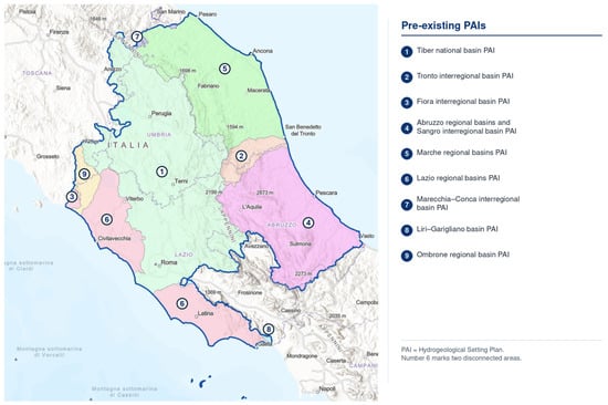
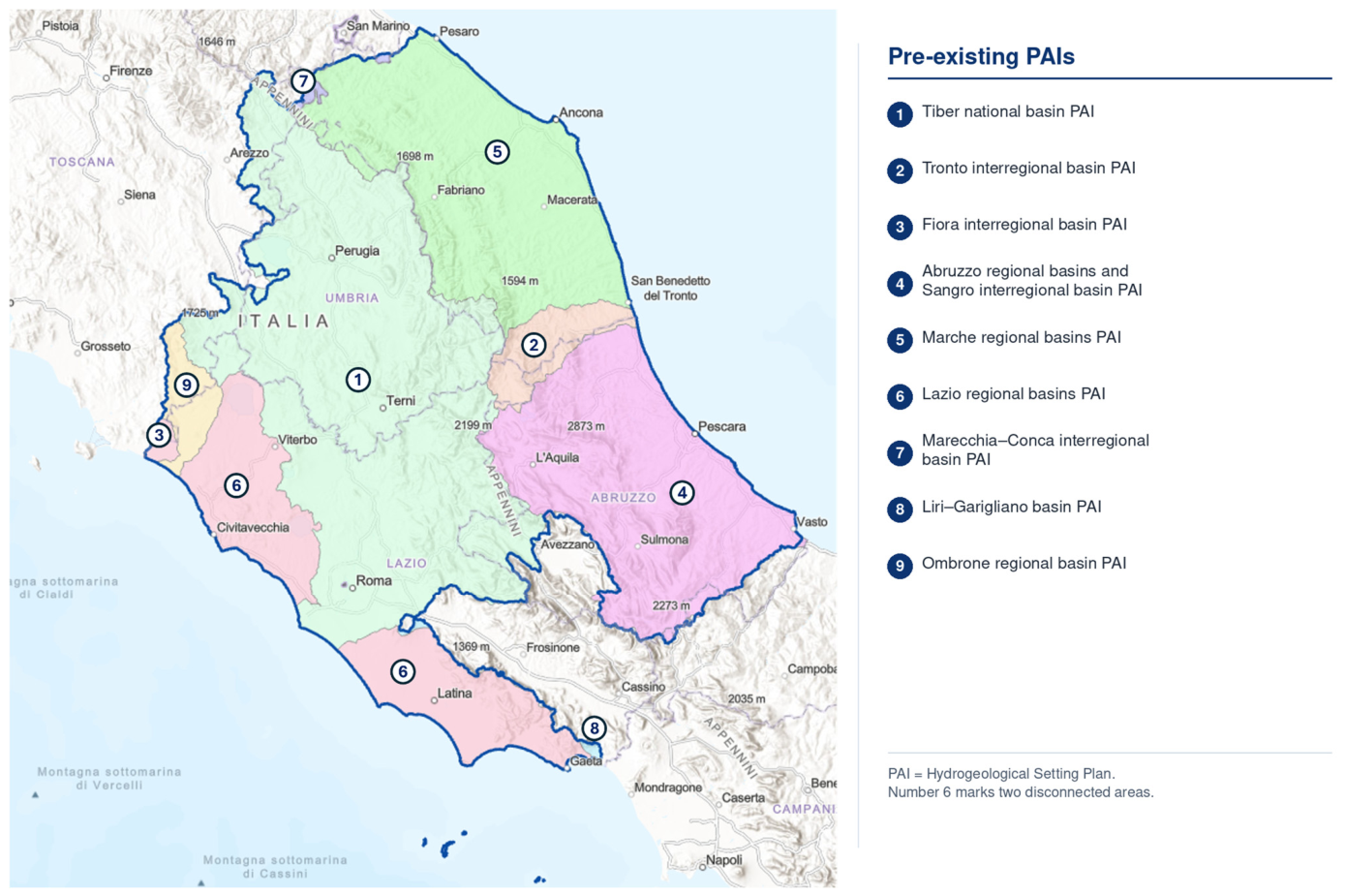
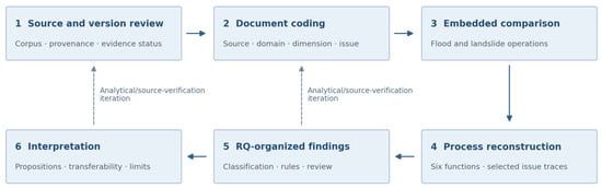
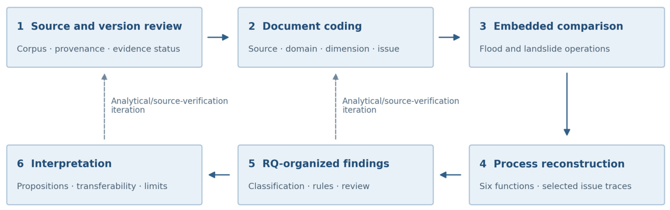
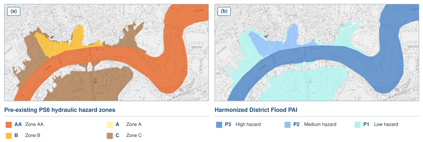
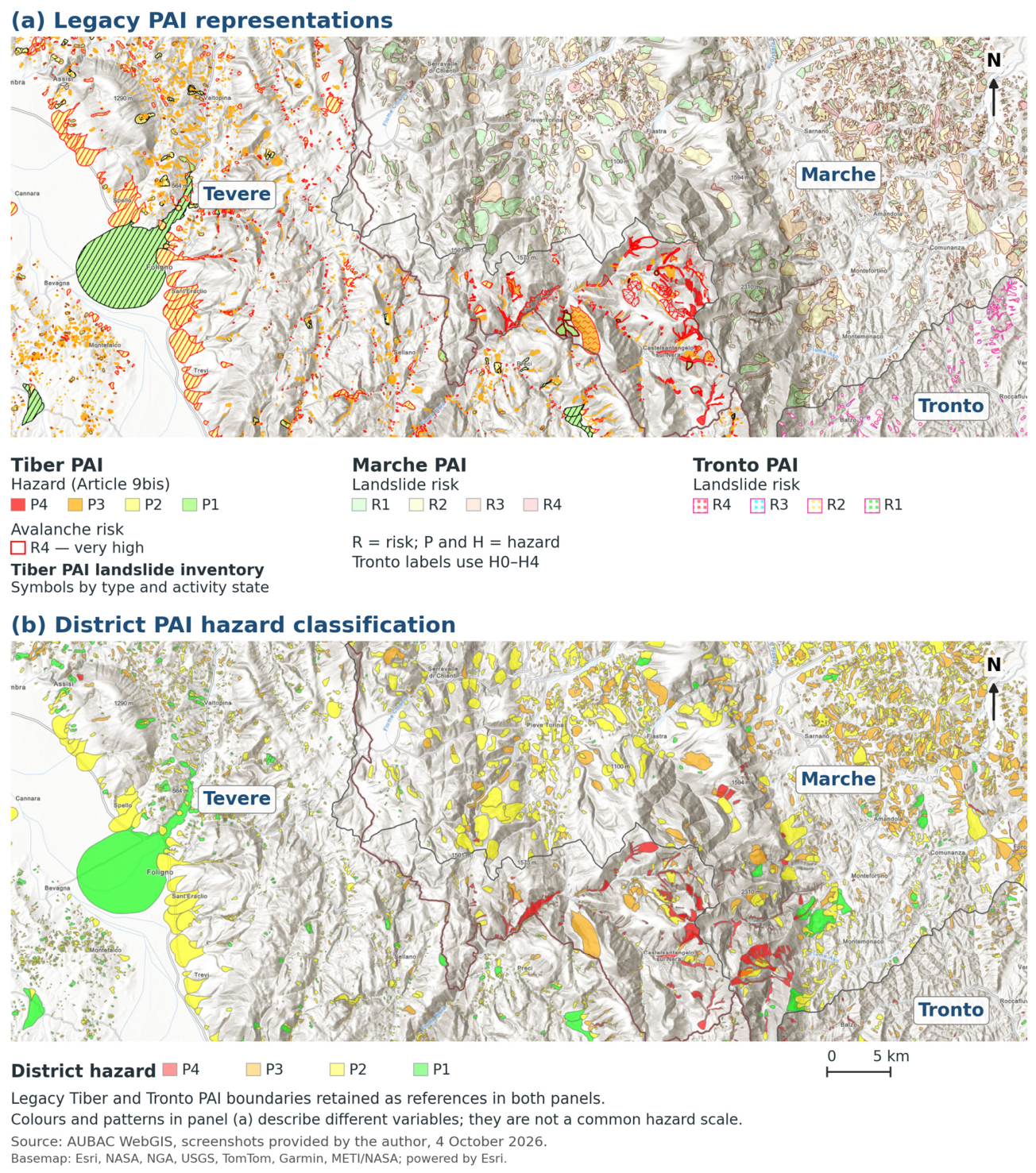
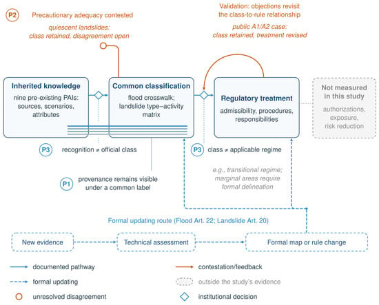
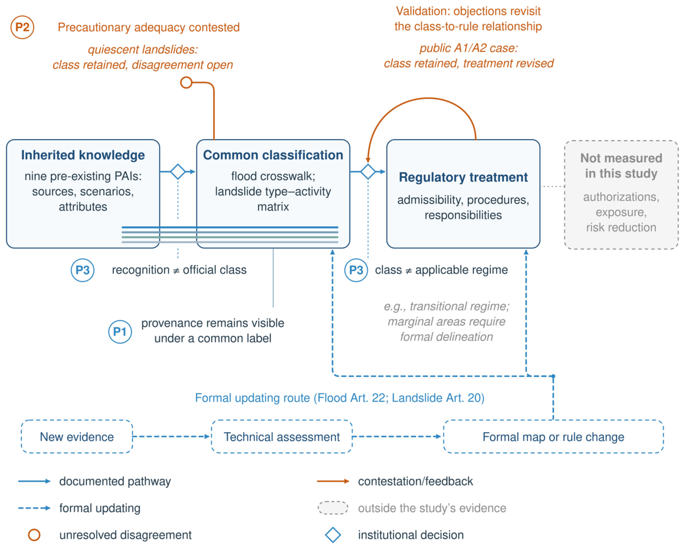

Disclaimer/Publisher’s Note: The statements, opinions and data contained in all publications are solely those of the individual author(s) and contributor(s) and not of MDPI and/or the editor(s). MDPI and/or the editor(s) disclaim responsibility for any injury to people or property resulting from any ideas, methods, instructions or products referred to in the content. |
© 2026 by the author. Licensee MDPI, Basel, Switzerland. This article is an open access article distributed under the terms and conditions of the Creative Commons Attribution (CC BY) license.