


Abstract
Policies aimed at accelerating the energy transition increasingly rely on simplified spatial criteria to identify suitable areas for renewable energy facilities, including ground-mounted photovoltaic (PV) plants on agricultural land. Yet these criteria often overlook soil quality, thereby fuelling the conflict between energy production and agriculture. This paper examines this issue through the case of Emilia-Romagna, Italy, focusing on the 350 m solar belts around industrial and commercial facilities, recognised as legally designated suitable areas for ground-mounted PV plants. Using GIS techniques, regulatory buffers were integrated with land-use data, land capability data, and the location of existing plants. The results show that solar belts include extensive ordinary agricultural areas, not subject to environmental or landscape constraints, and a significant share of high-quality soils belonging to classes I and II of the Land Capability Classification. Comparing actual pressure exerted by existing plants with potential exposure associated with suitable areas identifies different situations at the municipal scale. The case study shows that renewable energy deployment, unless guided by selective criteria, may increase pressure on the highest-quality agricultural soils. This points to the need to integrate pedological assessment into energy planning, moving beyond a definition of suitable areas based on simple geometric criteria.
1. Introduction
The shift towards renewable energy sources (RES) is one of the major challenges of the twenty-first century, essential for addressing the climate crisis and strengthening energy security in a context of growing geopolitical instability. Against this background, solar photovoltaics plays a key role: worldwide, at the end of 2025, it accounted for 46.5% of total installed renewable capacity, namely 2391 out of 5149 GW [1]. The European Union also relies heavily on this technology [2]. The EU Solar Energy Strategy, adopted in 2022 as part of the REPowerEU package, aimed to reach 320 GW of installed photovoltaic capacity by 2025: a target achieved ahead of schedule, while the subsequent 2030 target, initially set at 600 GW, has been raised to 700 GW. In the specific case of Italy, the National Integrated Energy and Climate Plan (Piano Nazionale Integrato per l’Energia e il Clima, PNIEC), updated in 2024, aims to reach 80 GW of installed photovoltaic capacity by 2030, with a net increase of about 43 GW compared with end-2024 levels, and has set differentiated development targets for each region.
The recent surge in photovoltaics has been driven by continuous improvements in the efficiency of plants and storage systems, the sharp decline in the cost of panels, the provision of specific public incentives, and the modularity and versatility of the technology, which allow it to be deployed in very different contexts. However, there is also a “dark side”: due to the high land-use intensity of this technology, large areas are required for the installation of panels [3]. This is a significant issue in historic centres, where the integration of photovoltaics must be carefully considered in order not to alter the character of places [4]. Yet the problem becomes particularly evident on agricultural land, when ground-mounted PV plants are installed. A contradiction emerges: solar farms make it possible to accelerate the energy transition, but they also trigger land take and a conflict between energy production and agriculture, often giving rise to local opposition and NIMBY effects [5,6,7,8].
There is now growing interest in agrivoltaics, based on a logic of dual land use that makes it possible to combine energy and agricultural production. However, these systems are costly, not suitable for all crops, and must be carefully designed and monitored so as not to reduce agricultural productivity [9,10]. For this reason too, despite policy efforts to favour the siting of ground-mounted PV plants in already urbanised or degraded areas, the pressure to occupy agricultural land with conventional ground-mounted panels remains strong. For investors, this makes it possible to maximise energy production while avoiding many of the technical constraints typical of building rooftops and already urbanised contexts; for farmers, the sale or lease of plots for energy uses may provide an attractive supplementary source of income [11].
From a geographical perspective, the expansion of ground-mounted PV plants in rural areas has been examined mainly by focusing on land take, the social acceptance of these plants, and landscape impacts, in both their objective and subjective dimensions [12]. On this first issue, the literature has not only identified ground-mounted PV plants as one of the main drivers of land take in rural areas [13], but has also devoted considerable attention to the crops they replace [14]. This perspective should also be broadened to consider the land capability of the soils involved. Ground-mounted PV plants tend to favour flat surfaces, which often coincide with the most fertile and productive soils, namely those belonging to classes I and II of the Land Capability Classification (LCC) developed by the USDA [15]. These are soils with few or no limitations for agricultural use: the most valuable agronomic “capital”, which should be protected by directing ground-mounted PV plants towards less productive land or, preferably, towards already urbanised contexts [16,17]. The debate on the protection of prime farmlands in the United States and best and most versatile lands in the United Kingdom moves precisely in this direction [18,19].
It should also be considered that, although ground-mounted PV plants entail temporary and reversible land take, they alter the physical, hydrological, and microclimatic characteristics of the occupied soils, with effects on agricultural practices and ecosystem services that may remain visible even after the panels have been removed [20]. In light of all this, the protection of the best soils should be a priority criterion in siting decisions.
Within this general framework, in the Italian context, the issue of legally designated suitable areas (aree idonee ope legis) for ground-mounted PV plants needs to be considered. These areas correspond to a legal definition of the sites regarded as most suitable for plant installation. In order to implement European directives aimed at accelerating the energy transition, in 2021 the Italian government drew up a first list of ope legis suitable sites for different RES and entrusted the regions with the identification of further areas on the basis of national criteria, defined in 2024 and subsequently reformulated. The picture is further complicated by the fact that, in 2024, the installation of ground-mounted PV plants on agricultural land was banned, with only ope legis suitable areas and a few other cases being exempted.
This study focuses on a specific category of ope legis suitable areas for ground-mounted PV plants: agricultural areas within 350 m belts around industrial and commercial facilities, here referred to as solar belts. The hypothesis underlying the paper is that this legal provision, based on simple geometric parameters, may expose even the best agricultural soils, namely those included in LCC classes I and II, to potential use for ground-mounted PV plants. The case considered is Emilia-Romagna, a highly urbanised region that is also characterised by a strong agricultural vocation. This case study is also relevant because Emilia-Romagna is the third Italian region, after Apulia and Lazio, in terms of the extent of ground-mounted PV plants [21]. The spread of these structures has already affected soils belonging to LCC classes I and II to a significant extent [22]: starting from this evidence, the paper investigates the role of ope legis suitable areas as a possible vehicle for further pressure on the most valuable soils. The aim, therefore, is not to analyse the relationship between ground-mounted PV plants and agricultural areas in general terms, nor to assess the extent of suitable areas in relation to the targets set by the PNIEC [23], but rather to examine the extent to which the regulation on ope legis suitable areas may involve precisely the best agricultural soils. To this end, two dimensions are assessed at the municipal scale: actual pressure, inferred from the location of existing ground-mounted PV plants, and potential exposure, linked to the overlap between ope legis suitable areas and class I and II soils. In this way, the paper contributes to the debate on the territorial effects of the energy transition, showing that the acceleration of photovoltaics should be assessed not only in relation to targets for increasing installed capacity, but also in terms of the quality of the soils exposed to transformation.
2. Theoretical and Regulatory Framework
2.1. Ground-Mounted PV Plants, Suitable Areas, and Agricultural Land
There is now a substantial literature on the identification of suitable areas for ground-mounted PV plants and, more broadly, for RES. Beyond the variety of techniques used, these studies are relevant to the economic sustainability of investments, the reduction in environmental and territorial impacts, and the possibility of striking a balance between the often conflicting interests of public authorities and private operators [24]. Many investment projects, especially large ground-mounted PV plants in rural areas, are opposed by local communities, which fear processes of land grabbing and energy colonialism [25,26,27]. Against this background, identifying the most suitable areas for hosting ground-mounted PV plants can help reduce siting conflicts and, at the same time, accelerate the energy transition.
In the early stages of ground-mounted PV development, siting decisions were driven by the search for the most convenient sites for exploiting low-cost energy [28]. Later, during the 2000s, attention shifted to a broader set of factors, not only economic but also technical, environmental, and social, to capture the different implications associated with ground-mounted PV plants. Within this framework, multi-criteria decision-making (MCDM) methods, often integrated with GIS tools, have taken on a central role in the selection and mapping of optimal sites for plant location. More recently, the use of artificial intelligence and optimisation algorithms has further improved the accuracy of decision-making processes [29].
The extensive literature on suitable areas is structured around a basic distinction between exclusion criteria and evaluation criteria. The former aim to identify areas where the siting of ground-mounted PV plants is precluded, for example, because of environmental and landscape constraints, risk conditions, or specific land-use designations. The latter, by contrast, make it possible to rank siting alternatives on the basis of a mix of different factors, thereby outlining a hierarchy of potentially more suitable sites for ground-mounted PV plants. The choice of criteria—one of the most delicate aspects of the entire evaluation process—is influenced by data availability, the geographical context, and the authors’ theoretical and methodological approach. In their detailed review, Shao et al. [28] identified as many as 17 methods for selecting exclusion and evaluation factors, stressing that surveys of the existing literature and consultation with sector experts are the most widely used approaches. The same authors also point out that the criteria adopted for ground-mounted PV plants and wind energy are similar, and that land use is one of the most frequently considered factors. However, land use has an ambivalent character: it is often used as an evaluation criterion, but it may also act as an exclusion factor, like other constraints commonly found in these studies, such as the presence of cultural heritage assets, protected areas, and risk conditions, as well as proximity to the electricity grid and distance from infrastructure and settlements.
Looking more closely at the way agricultural land is treated, a varied picture emerges. Despite some inevitable overlaps, four main approaches can be identified: (1) a technical-functional approach; (2) an exclusionary approach; (3) an approach differentiated by land use; and (4) an approach differentiated by agronomic quality.
Studies falling within the first approach treat agricultural land as a physical support, disregarding its actual uses and its qualitative or pedological characteristics. What matters, instead, are certain technical and morphological parameters, especially slope, solar irradiation, accessibility, and proximity to electricity grids [30,31]. Some studies also consider land cost, pointing out that—especially for large plants—a low purchase or rental price can reduce the overall cost of the project and improve its profitability [32]. Although the use of land cost as an indicator is interesting and innovative, this approach remains limited because agricultural land is not differentiated according to its intrinsic value, but is flattened into technical and financial metrics.
In the second approach, agricultural areas are considered unsuitable as a whole for the siting of ground-mounted PV plants. Unlike in the previous approach, land use is an “active” criterion, but agricultural areas are treated as a single category, without internal distinctions relating to the crops grown, agronomic quality, or pedological characteristics. This choice may depend on restrictive regulations in force at the national or local scale [33], but more often it stems from the sensitivity of scholars who, adopting a conservative approach, seek to limit the conflict between energy and food production and, more generally, to contain the ecological and environmental impacts of ground-mounted PV plants [34,35]. In some studies, agricultural areas are not only excluded, but buffer zones are also established around them [36], following a logic of extended spatial protection that can substantially reduce the availability of areas for ground-mounted PV plants. In other cases, agricultural land is not excluded altogether, but receives lower scores in the evaluation than, for example, sterile and barren land, where low vegetation does not hinder solar exposure [37]. Even in this less restrictive approach, however, agricultural land continues to be treated as a homogeneous category.
This is not the case in the third approach, which breaks up the unitary treatment of agricultural areas by considering the different crops present and their compatibility with ground-mounted PV plants. As a result, some agricultural uses are excluded, others are deemed admissible, and still others are ranked according to different levels of suitability. Positions range from cautious approaches, which consider only the most marginal crops as suitable, to more permissive ones, which also allow more productive land depending on specific local conditions [38,39]. An original approach is proposed by Doljak and Stanojević [40], who, in addition to a “fine-grained” reading of crops, use vegetation-cover indices, such as the Normalised Difference Vegetation Index (NDVI), to select areas with lower biomass. However, the two authors acknowledge a limitation of their method: the lack of reference to land capability, which would have provided information on the actual quality of soils under the same crops.
Attention to this latter aspect characterises the studies falling within the fourth approach, which are not very numerous but are relevant to this paper. In these studies, agricultural land is assessed not only according to the crops present, but also in relation to its pedological characteristics and agronomic potential. Drawing on the LCC, higher-quality land, that is, more fertile and productive land, is excluded or heavily penalised, so as to redirect ground-mounted PV plants towards areas less suitable for agriculture [24,41,42]. The rationale is clear: the best soils should not be sacrificed for energy production.
A different overall approach can be found in the literature on suitable areas for agrivoltaic systems. Here, land use always receives considerable attention, because it is based on a logic of dual land use, which makes it necessary to maximise compatibility between energy production and agricultural productivity. Factors such as crop tolerance to shading, the configuration of elevated modules, and the feasibility of agricultural operations therefore become relevant [43]. Land capability is also sometimes considered, albeit in different ways. In some cases, attention to this aspect is indirect, insofar as slope is addressed as a key factor for agrivoltaic systems. Slope is, in fact, one of the factors included in the LCC; it affects both agricultural practices and the siting of agrivoltaic systems, which face greater constraints than conventional ground-mounted PV plants. From this perspective, Gasparini et al. [44] consider a maximum slope of 15% to be optimal and highlight that this threshold is typical of medium- to high-quality agricultural soils, corresponding to LCC classes I–III.
Other authors refer explicitly and directly to the LCC to identify the best sites for agrivoltaics. Fattoruso et al. [45] follow this approach and, in the case of Italy, consider class II soils to be optimal for the development of agrivoltaics, while excluding class I soils.
Overall, agrivoltaics can be said to shift the terms of the debate: agricultural land is not treated as a constraint or as a category to be excluded, but as a resource to be kept in use within an integrated framework combining energy and agricultural production. However, there is a substantial difference from studies on ground-mounted PV plants that focus on land capability, corresponding to the fourth approach discussed above: reference to the LCC is not used to protect the highest-quality soils from the advance of panels, but rather to identify the best siting opportunities.
This paper also intersects with a further strand of studies, namely those that analyse the impacts of ground-mounted PV plants ex post by reconstructing the land uses they have replaced. From this perspective, it is clear that ground-mounted PV plants, although distributed across a plurality of sites, tend to affect agricultural areas to a significant extent, often more than wind power, with relevant effects in terms of land take [46,47,48,49,50]. The crops displaced by the advance of panels vary according to local contexts, but the result is nevertheless a transformation that subtracts space from agriculture, fragments the territory, and produces an “industrialisation” of agricultural landscapes that is not well received by local communities [7,51,52]. However, these studies too tend to focus on broad land-use categories and on the visual effects of their replacement, leaving the intrinsic quality of the affected land in the background.
Despite this rich range of nuances, studies on the site suitability of ground-mounted PV and agrivoltaic systems, as well as those on replaced land uses, leave a crucial issue in the shadows: the risk that regulatory mechanisms for identifying suitable areas may selectively overlap with the highest-quality agricultural soils. It is precisely within this unexplored space that this paper is positioned. It does not propose an exercise in suitability mapping, nor does it assess the efficiency of the agrivoltaic model. Rather, its aim is to critically examine whether ope legis suitable areas may act, in the case of Emilia-Romagna, as a vehicle for further pressure on the most valuable agricultural soils.
2.2. Legally Designated Suitable Areas in Italy
In Italy, until 2024, the siting of ground-mounted PV plants on agricultural land not subject to environmental or landscape constraints was not subject to stringent limitations, although regional approaches varied in their degree of permissiveness [53]. The picture changed with Decree-Law 63/2024, the so-called “Agriculture Decree”, converted with amendments by Law 101/2024, which introduced a genuine tightening of the rules on the spread of ground-mounted PV plants in agricultural areas, favouring degraded and urbanised sites instead. These restrictions—which do not apply to agrivoltaics—were called into question in the early months of 2025, as they were considered excessive and at odds with European objectives for accelerating the energy transition. In July 2026, however, the Italian Constitutional Court, with Judgment No. 127/2026, declared unfounded the constitutional challenges raised against the relevant provisions of the Agriculture Decree. This opened up a phase of uncertainty, further fuelled by disputes over the redefinition of the rules on suitable areas: the relevant criteria, defined by the Ministerial Decree of 21 June 2024, were reformulated by Decree-Law 175/2025, subsequently converted with amendments by Law 4/2026. All this contributed to slowing down photovoltaic development during 2025 [54]. At the same time, however, there was an increase in applications for new plants, which seems to suggest that, in a context of uncertainty, many investors adopted a first-mover strategy.
In the current regulatory framework, the installation of ground-mounted PV plants on agricultural land is strongly limited, but not entirely excluded. In particular, it is still permitted within the 300 m belts along motorways and within the 350 m belts around industrial and commercial facilities, the latter being known as solar belts. For the 350 m belts, their legally defined width was reduced: under the previous Legislative Decree 199/2021, it had been 500 m. This reveals a contradiction between the need to safeguard agricultural areas and the need to accelerate the deployment of RES, since simplified procedures for the siting of ground-mounted PV plants apply in ope legis suitable areas. This entails a critical issue: the conversion of agricultural soils for energy purposes is legally allowed without taking into account their actual land-use status or their agronomic quality. Even the most valuable soils are therefore at risk of transformation.
At the national level, Emilia-Romagna has always stood out for its restrictive approach to the governance of ground-mounted PV plants. Evidence of this can be found in the previous legislation dating back to 2010, which set limits on the expansion of plants in relation to the agricultural land available to the applicant, with a maximum threshold of 10%, and on the nominal capacity that could be installed. The framework did not change substantially with the revision of the rules in 2023, and encouraged the sprawl of small “photovoltaic patches”, generally more easily accepted by local communities [12]. Alongside these constraints, the Emilia-Romagna Region sought to favour the siting of ground-mounted PV plants in already urbanised and degraded areas, particularly in disused quarries, for which surface-area limits and minimum distance requirements were revised in a more permissive direction.
In May 2026, following the new criteria established by Decree-Law 175/2025, the Emilia-Romagna Region approved its own law for the identification of suitable areas. In addition to broadening the range of such areas to include a wide spectrum of urbanised sites, three aspects should be highlighted. First, the regional law seeks to limit the spread of ground-mounted PV plants in the areas around industrial and commercial facilities: here, priority is given to the installation of plants mainly intended for the self-consumption of local firms or firms based within the regional territory. Although useful for promoting firms’ energy autonomy, this measure represents an additional constraint compared with national rules. Quantitative limits are also set on the expansion of RES in rural areas, since the thresholds of 1.5% of utilised agricultural area at the regional level and 2.5% at the municipal level cannot be exceeded. Finally, the regional law specifically protects certified crops, including PDO/PGI products, organic and integrated production, and forage production within the area of origin of Parmigiano Reggiano. In all these areas, agrivoltaic systems may be installed, whereas for ground-mounted PV plants, the absence of certified crops in the previous three-year period must be verified. Overall, a quantitative approach prevails in the governance of the energy transition, with limited attention to soils of higher agronomic quality, which do not necessarily coincide with the areas of certified crops. Pedological and soil-quality aspects are taken into account only for agrivoltaic systems, for which monitoring systems for soil fertility and microclimate are required. These requirements, however, do not amount to ex ante siting criteria; rather, they are ex post control parameters intended to verify that the plants do not compromise the agricultural function of the site.
3. Materials and Methods
The starting point of the analysis was the identification of ordinary agricultural areas, namely areas not subject to environmental or landscape constraints, located within the 350 m belts around industrial and commercial facilities in Emilia-Romagna. As noted above, these areas legally qualify as suitable for the installation of ground-mounted PV plants. Using the Regional Land Use Map (2023; available at: https://geoportale.regione.emilia-romagna.it/ at the fourth level of detail, the maximum available, polygons classified as “industrial, craft, and commercial facilities” were selected, corresponding to 29,689 ha. All spatial analyses were performed in QGIS 3.40.10 using the WGS 84/UTM zone 32N reference system (EPSG:32632), after checking and repairing the few invalid vector geometries.
Around each polygon, 350 m buffers were generated in QGIS 3.40.10, distinguishing agricultural areas from other land uses. To avoid double counting due to possible overlaps, the buffers were dissolved. From the agricultural areas thus selected, areas subject to environmental and landscape constraints were excluded, in line with the criteria adopted in the national atlas of suitable areas [55]. More specifically, areas of notable public interest, pursuant to Article 136 of the Cultural Heritage and Landscape Code, buffer zones along coasts and water bodies, wetlands, protected natural areas, Natura 2000 sites, Important Bird Areas, and Ramsar wetlands were excluded. At the end of this procedure, the agricultural areas around industrial and commercial facilities that qualify ope legis as suitable for the installation of ground-mounted PV plants amounted to 134,500.8 ha.
In addition to considering the types of crops present in these areas, as derived from the Land Use Map, the quality of the soils involved was also investigated, using the Regional Land Capability Map for Agricultural and Forestry Purposes (available at: https://geoportale.regione.emilia-romagna.it/), updated to 2021, at a scale of 1:50,000. This map, based on the LCC [15], identifies eight main classes, the first four of which include soils suitable for agriculture, with progressively increasing limitations. Using GIS-based spatial intersection techniques, the land capability classes of the ordinary agricultural areas located around industrial and commercial facilities were identified, with particular attention to the presence of class I and class II soils, those of the highest agronomic quality. In all analyses, the distinction between these two soil classes was maintained, since they were differently distributed across the region.
Starting from these data, two municipal-level indicators were developed specifically for this study to assess potential exposure and actual pressure on high-capability agricultural soils. The first, the Potential Exposure Index (Eci), was calculated as follows:
where Bci represents the agricultural area of soil class i—class I or class II—falling within the buffers around industrial and commercial facilities in municipality c, while Aci indicates the total agricultural area of the soil class considered in municipality c. In municipalities where Aci is equal to zero, the indices were not calculated, since the soil class considered is not present.
Eci = (Bci/Aci) × 100
The Eci index measures the share of the agricultural area of the class considered that, in each municipality, falls within the solar belts. The higher the value, the greater the potential exposure of the soil class considered and, consequently, the potential risk of land-use conflict associated with the mechanism of ope legis suitable areas. It should be emphasised that this is potential exposure, or potential pressure, since the actual colonisation of these areas by ground-mounted PV plants is not certain: it is only made easier and more attractive by the legislation in force, while investors’ strategies, local planning dynamics, and authorisation procedures also play a role. In this study, LCC is used as an indicator of the agronomic capability of land; it should not be interpreted as a direct measure of actual agricultural productivity, economic value, or strategic importance for food security, which depend on additional economic and territorial factors.
Still at the municipal level, the second indicator, the Actual Pressure Index (Pci), was calculated as follows:
where Fci represents the agricultural area of soil class i—class I or class II—already occupied by ground-mounted PV plants.
Pci = (Fci/Aci) × 100
This index assesses the extent to which the advance of ground-mounted PV plants has so far occurred at the expense of the most valuable agricultural soils, not in absolute terms, but in relation to their differing extent within individual municipalities.
To calculate this index, in addition to the Regional Land Capability Map, the mapping of existing ground-mounted PV plants as of 30 September 2025, developed in previous research [22], was used. This dataset was constructed starting from the 2020 Regional Land Use Map (https://geoportale.regione.emilia-romagna.it/), the most recent available when that research began. At the fourth level of detail, polygons classified as “ground-mounted photovoltaic plants” (code 1228) were selected, covering 1936.3 ha in 1018 polygons. A further 151.3 ha (26 polygons) were added by georeferencing the plants authorised after 1 January 2020 in QGIS 3.40.10, based on the regional authorisation database, and verifying their actual presence in Sentinel-2 imagery available up to 30 September 2025. Sentinel-2 imagery was therefore used for visual validation rather than for remote-sensing classification. Overall, the dataset includes 2087.6 ha distributed across 1044 polygons. The mapped area refers to the fenced site occupied by each plant, including modules, inter-row spaces, access roads, and service infrastructure.
As a next step, by jointly considering the Eci and Pci indices, municipalities were classified into groups, using the median values of the two indices as discriminating thresholds. The medians were calculated after excluding municipalities with zero values, so as to avoid excessive flattening in the distribution of values, which would reduce the analytical power of the classification. The resulting thresholds were 20.01% for Eci and 20.89% for Pci in LCC class I, and 15.82% and 15.24%, respectively, in LCC class II. In this classification, the terms “high” and “low” are used in a relative sense, referring to values above or below the corresponding median, and should not be interpreted as absolute or normative thresholds.
In this way, for each of the two soil classes considered, five profiles were identified:
- (A)
- high actual pressure and high potential exposure;
- (B)
- high actual pressure and low potential exposure;
- (C)
- low actual pressure and high potential exposure;
- (D)
- low actual pressure and low potential exposure;
- (E)
- no actual pressure and no potential exposure.
As a sensitivity check, medians were also recalculated including zero values for municipalities in which the corresponding LCC class was present; under this specification, the median Pci was equal to 0% for both classes, substantially reducing the discriminatory capacity of the classification. A further check using the upper quartile (Q3) as a stricter threshold reduced the number of municipalities assigned to profiles A and C, but both configurations remained identifiable in the two soil classes.
Finally, to assess how the Eci and Pci indices vary along the urban–rural gradient, the Degree of Urbanisation (DEGURBA) classification, harmonised at the European level and based on population size and population density within a grid of 1 km2 cells, was used [56]. According to this classification, in Emilia-Romagna, 11 municipalities—the provincial capitals plus Carpi and Sassuolo—are classified as cities, corresponding to densely populated areas; 119 municipalities are classified as towns and suburbs, corresponding to intermediate-density areas; and the remaining 200 municipalities fall within rural areas, corresponding to sparsely populated areas. To assess whether municipal-level differences in Eci and Pci across DEGURBA groups were statistically meaningful, the distributions were summarised using the median and interquartile range (Q1–Q3) and compared using the non-parametric Kruskal–Wallis test. For each LCC class, only municipalities in which that class is present were considered, while zero values of the indices were retained.
4. Results
4.1. Ground-Mounted PV Plants and Potential Areas
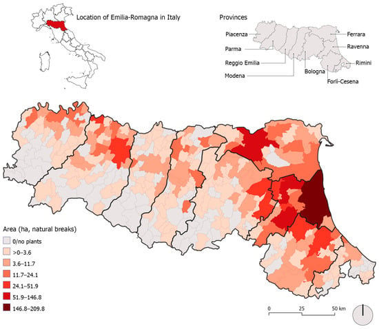
In Emilia-Romagna, ground-mounted PV plants are located mainly in flat areas, with a more marked concentration in the eastern part of the region, where solar irradiance values are higher (Table 1, Figure 1).
Table 1.
Ground-mounted PV plants in Emilia-Romagna as of 30 September 2025, by province and degree of urbanisation.
Figure 1.
Municipal area occupied by ground-mounted PV plants in Emilia-Romagna as of 30 September 2025. Source: Author’s elaboration based on data from the Emilia-Romagna Region; see Section 3.
The province of Ravenna stands out above all: although relatively small in area, it accounts for as much as one third of the total area occupied by ground-mounted PV plants, with the municipality of Ravenna playing a leading role as one of the country’s major energy hubs. If, in addition to Ravenna, the neighbouring provinces of Forlì-Cesena, Bologna, and Ferrara are also considered, the share of the area occupied by ground-mounted PV plants rises to 69.3% of the regional total. So far, the spread of these structures has occurred mainly at the expense of agriculture, in particular by replacing arable land and orchards, crops that are typical of the regional landscape. Only 10.1% of the areas occupied by ground-mounted PV plants are located in quarries, landfills, and other already urbanised sites [22].
This “real” geography of ground-mounted PV plants can be compared with the “potential” geography of the solar belts surrounding industrial and commercial facilities, which are considered ope legis suitable for the installation of ground-mounted PV plants. Within 350 m of these facilities, there are 134,500.8 ha of ordinary agricultural areas, not subject to constraints, corresponding to 11.2% of all agricultural areas in the region. This is far from a marginal share, and shows how the mechanism of ope legis suitable areas intercepts a significant portion of the regional agricultural space. At present, only a small share of the area occupied by ground-mounted PV plants is already located within the buffers considered, namely 21.1%. This value is reported as a descriptive measure of the current spatial overlap and should not be interpreted as evidence of the probability of future development within solar belts, since existing PV locations may also be influenced by factors such as grid accessibility, land prices, infrastructure, terrain, and land ownership.
The presence of solar belts potentially available for new ground-mounted PV plants does not concern a few isolated cases, but extends across almost the entire regional territory, with the exception of nine municipalities. It is nevertheless clear that the areas involved are larger in the plains than in hilly and mountain areas. This pattern reflects, at least in part, the distinctive Emilia-Romagna model of diffuse industrialisation driven by SMEs, which has generated an archipelago of productive areas located on urban fringes or in the open countryside.
A significant difference emerges from these initial data between the “real” geography of ground-mounted PV plants, dominated by the province of Ravenna, and the “potential” geography linked to the agricultural buffers around industrial and commercial facilities, which is decidedly more balanced in the distribution of provincial shares (Table 2).
Table 2.
Municipal distribution and ordinary agricultural areas within solar belts in Emilia-Romagna, by province and degree of urbanisation.
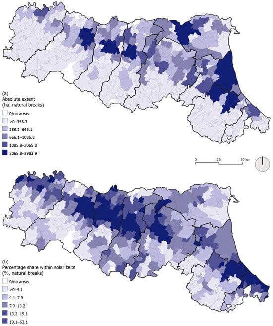
At the municipal scale (Figure 2a), if the extent of agricultural areas within the buffers is considered in absolute terms, the greatest availability is found both in the provincial capitals, as expected, and in a considerable number of other plain municipalities, located along the Via Emilia or in more peripheral positions. Intermediate municipalities, corresponding to towns and suburbs, play a key role: 46.4% of the total area of existing ground-mounted PV plants falls within their boundaries, a value that increases slightly in the “potential” geography to 47.1%.
Figure 2.
Ordinary agricultural areas within solar belts in Emilia-Romagna: (a) absolute extent; (b) percentage share. Source: Author’s elaboration based on data from the Emilia-Romagna Region; see Section 3.
Moving beyond absolute values and assessing the weight of ordinary agricultural areas within the buffers considered makes it possible to better understand which territories are more exposed to potential use for ground-mounted PV plants. At the provincial scale, Reggio Emilia, Rimini, Modena, Forlì-Cesena, and Bologna stand out, with values ranging from 17% to 11.8%, above the regional figure of 11.2%. At the opposite end, the province of Ferrara is the least involved, at 6.6%. The municipal-scale map (Figure 2b) shows maximum peaks along the Via Emilia, especially near Piacenza, between Parma and Bologna, and in the Cesena-Rimini area. Some medium-high values also occur in the Apennine area. Overall, values are higher in the group of cities, at 16.1%, and in intermediate municipalities, at 13.4%, than in rural areas, at 8.0%.
4.2. Soil Quality of Agricultural Land
Agricultural land uses within the solar belts, considered at the second level of detail, are largely dominated by arable land, which accounts for 81.6% and has already ceded extensive areas to the ground-mounted PV plants installed so far. Permanent crops are also far from negligible, accounting for 13.2%, and include orchards and vineyards, which have likewise already been replaced by photovoltaic panels, especially in the eastern part of the region. Smaller portions correspond to permanent meadows, at 4.0%, and heterogeneous agricultural areas, at 1.2%. Thus, in terms of agricultural land use, there are no major differences between the “real” geography of ground-mounted PV plants and the “potential” geography.
However, it is necessary to move beyond this finding to assess the potential exposure of the most valuable soils, those belonging to classes I and II. As Table 3 shows, this risk is present: not only is a very large share of the buffers made up of soils of high agronomic quality, at 70.5%, but their share is also higher than the overall presence of these soils in the region as a whole, with significant differences: 5.6 percentage points more for class I soils and as much as 17.1 percentage points more for class II soils. The spread of ground-mounted PV plants on these valuable soils is already clearly evident today and could become more pronounced in the future: this would be the almost paradoxical effect of a regulation based on predefined-width buffers, but inattentive to the quality of the soils it intercepts. It was probably assumed that agriculture near industrial and commercial facilities would play only a residual role; yet the buffers considered are wide, and they also include valuable soils, which are therefore potentially exposed to conversion to energy uses under the rules currently in force. The recent reduction in buffer width, from 500 to 350 m, has limited the problem, but it has not eliminated it, and the potential risk of land-use conflict involving high-quality soils remains evident.
Table 3.
Land capability of agricultural soils in Emilia-Romagna: comparison between the “real” geography of ground-mounted PV plants and the “potential” geography of solar belts, percentage values.
There is another significant element: if all agricultural areas included within the buffers are considered, both constrained and unconstrained, the most valuable soils are concentrated precisely in the ordinary portions, with a greater surplus for class I soils.
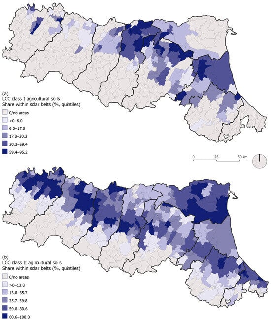
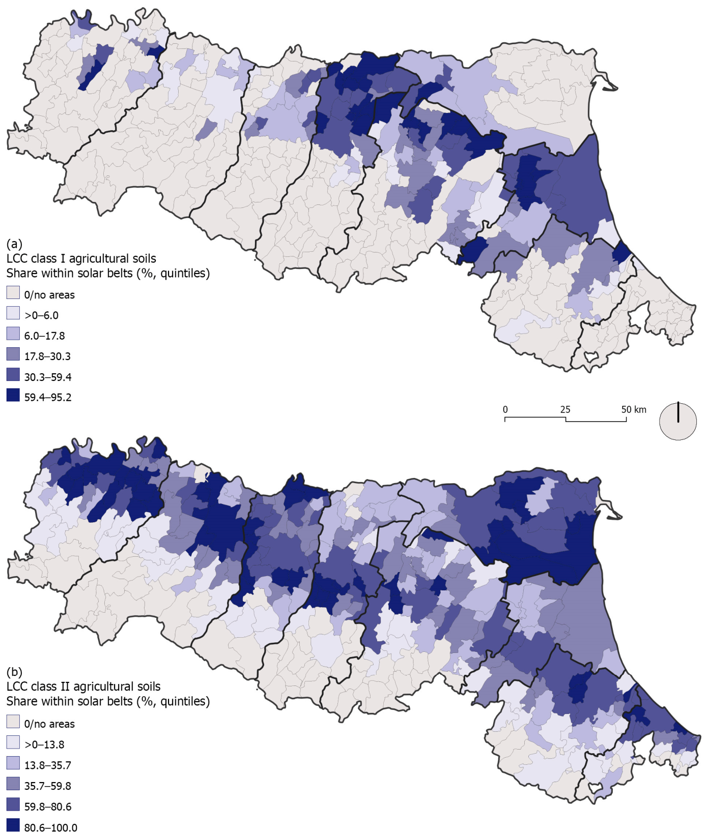
In 129 municipalities, the ordinary agricultural areas within the buffers around industrial and commercial facilities belong to class I. Many cases are concentrated in the central-eastern plain, where the incidence of soils in this class within the solar belts often reaches high values (Figure 3a). To the west, by contrast, the pattern is sparser and values are lower, with some exceptions. For class II soils, a different picture emerges (Figure 3b). They are present across much of the region, in both flat and hilly areas, so that the opposition between the eastern and western sectors, typical of class I, disappears. In 264 municipalities, class II soils fall within the solar belts, with a greater weight in the province of Ferrara and along the Via Emilia, especially between Piacenza and Modena.
Figure 3.
Share of agricultural soils with high land capability within solar belts in Emilia-Romagna: (a) LCC class I; (b) LCC class II. Source: Author’s elaboration based on data from the Emilia-Romagna Region; see Section 3.
The group of intermediate municipalities stands out from the others for the greater weight of class I soils within the buffers, at 18.0%, compared with 16.9% in cities and 12.9% in rural areas. For class II soils, by contrast, cities rank first, at 65.3%, compared with 56.7% in intermediate municipalities and 44.8% in rural areas.
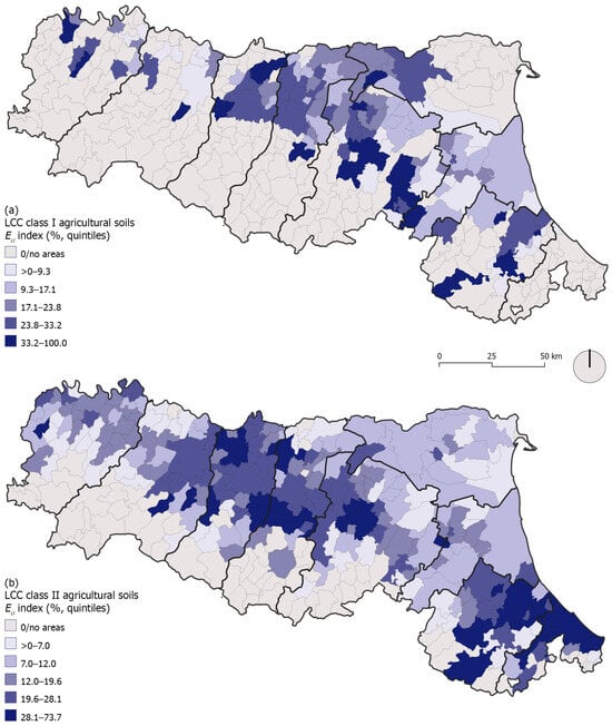
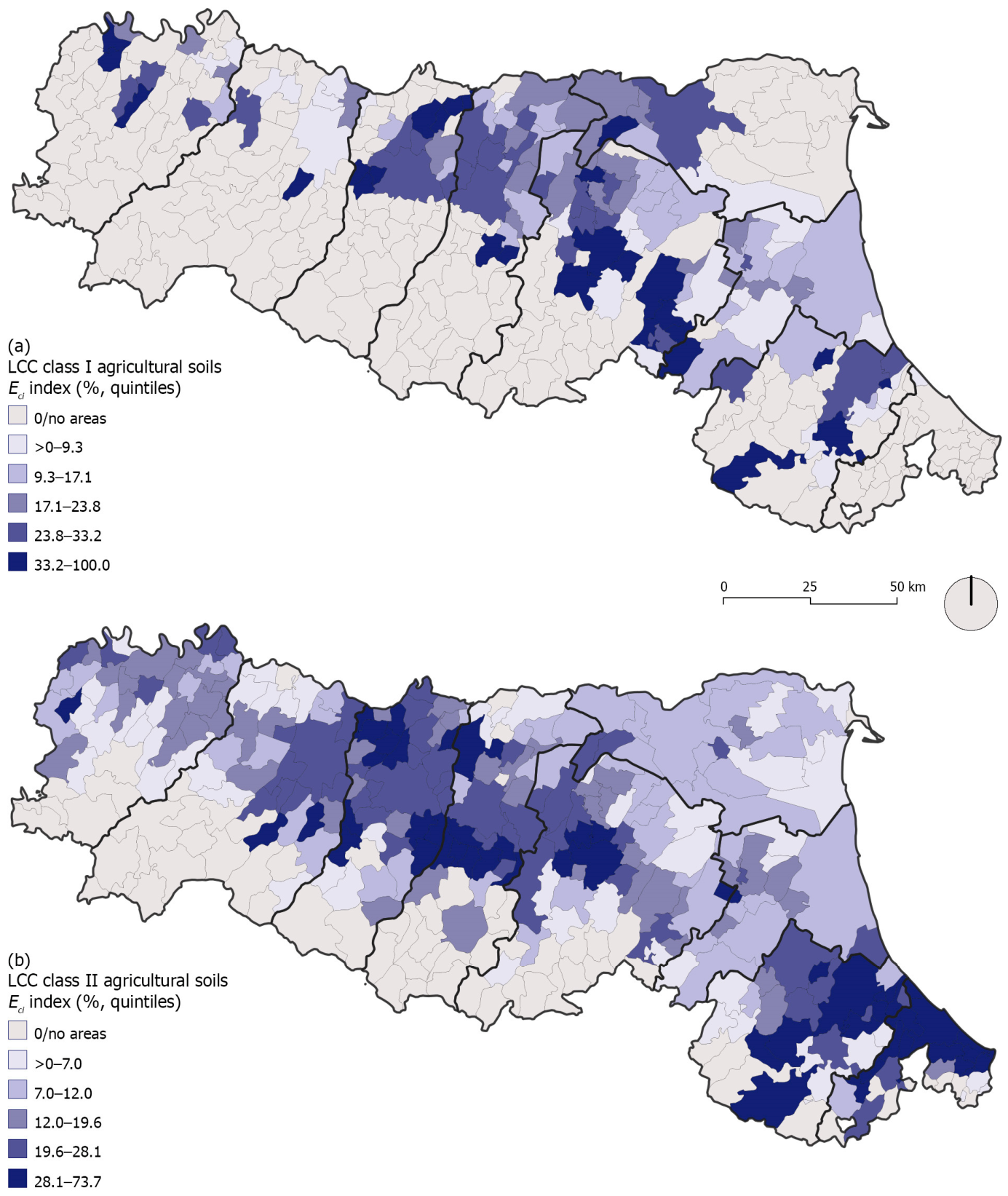
By considering the Eci index, it is possible to measure the potential exposure of each of the two soil classes examined. Higher values are found for class I (Figure 4a), especially in the Reggio Emilia–Bologna–Ferrara triangle and, more locally, in other more peripheral municipalities. Potential exposure is nevertheless also quite high for class II (Figure 4b), particularly in the central part of the region, between Modena and Bologna, and in the provinces of Forlì-Cesena and Rimini. Overall, these data show how the instrument of ope legis suitable areas may accentuate, in many municipalities, pressure on the highest-quality agricultural soils, reinforcing a trend already visible in the current distribution of ground-mounted PV plants [22].
Figure 4.
Potential exposure of high-capability agricultural soils within solar belts in Emilia-Romagna: (Eci index): (a) LCC class I; (b) LCC class II. Source: Author’s elaboration based on data from the Emilia-Romagna Region; see Section 3.
4.3. Classification of Municipalities
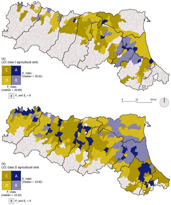
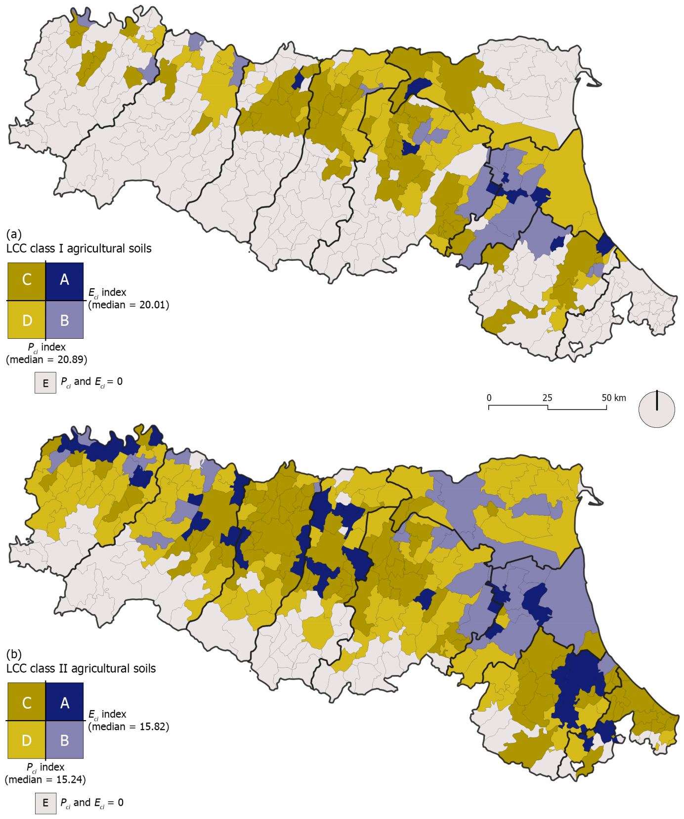
Figure 5a,b show the classification of municipalities based on the combination of the two indices: actual pressure exerted by ground-mounted PV plants (Pci) and potential exposure (Eci). A first difference between the two soil classes considered concerns the number of municipalities that are “out of play” because they have zero values for both indices. For class I, the most valuable and rarest class, this situation is found in the majority of municipalities, not only in hilly and mountain areas, but also across large stretches of the plain. For class II, which is more widespread across the region, the cases are few and almost all located in the Apennine area.
Figure 5.
Classification of Emilia-Romagna municipalities according to actual pressure (Pci) and potential exposure (Eci): (a) LCC class I; (b) LCC class II. Source: Author’s elaboration based on data from the Emilia-Romagna Region; see Section 3.
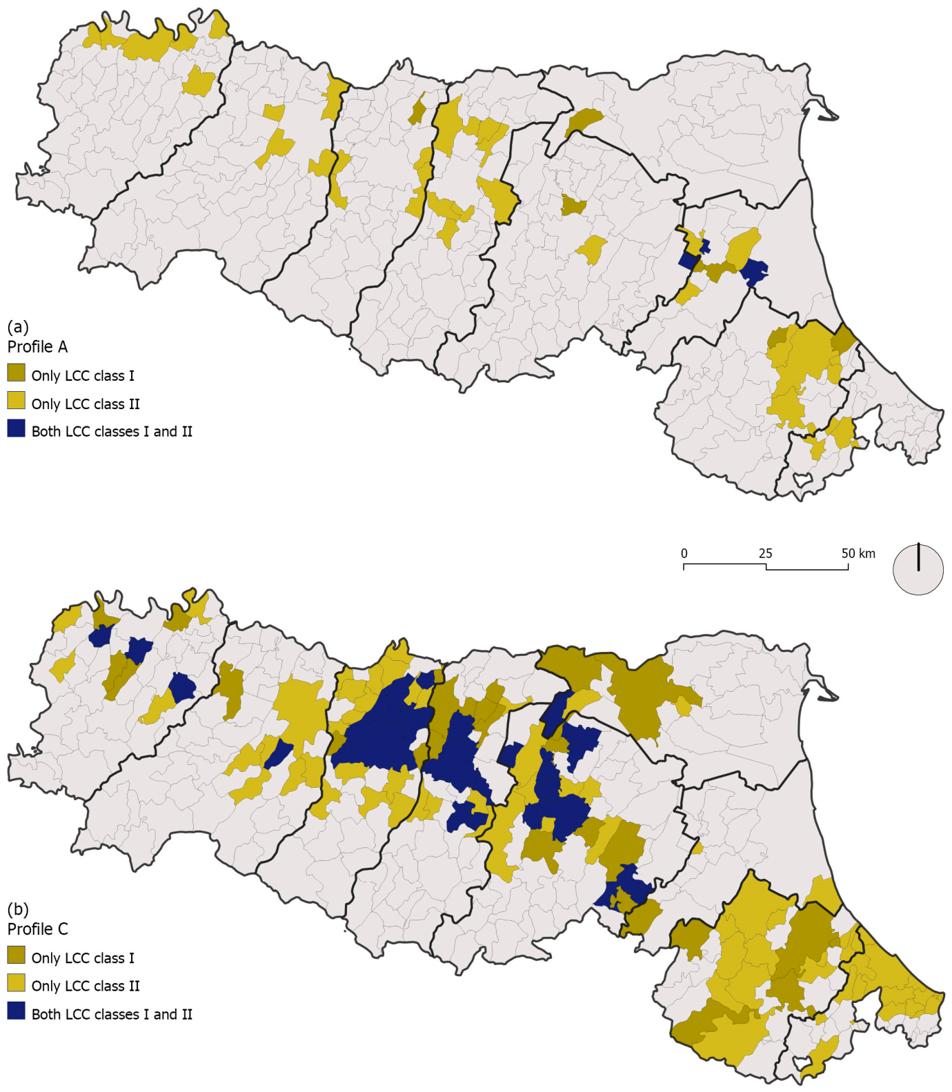
With respect to the classification adopted, profile A deserves particular attention. It identifies municipalities where a significant spread of ground-mounted PV plants has already occurred within the soil class considered, and where a substantial share of soils belonging to the same class falls within the buffers. This indicates an already active energy–agriculture conflict on valuable soils, which risks becoming more pronounced as a result of the rules on ope legis suitable areas. For class I soils, this situation concerns ten municipalities, grouped in a small cluster in the Ravenna area and distributed more locally in the provinces of Forlì-Cesena, Bologna, Ferrara, and Reggio Emilia. For class II, within an overall denser pattern, the 36 cases identified are distributed across all provinces except Ferrara.
Profile B applies to municipalities where valuable soils are already extensively occupied by ground-mounted PV plants, but where the remaining share of these soils is less concentrated within the buffers. In this case, it is possible to think in terms of a “historical conflict”, where ope legis suitable areas do not add a large potential burden. For class I, this is found in 17 municipalities, located mainly in the province of Ravenna. For class II too, many cases are located in this province, but the picture extends to the contiguous areas and to the western sector of the region, namely Piacenza and Parma.
Profile C identifies a situation opposite to the previous one: so far, valuable soils have been only marginally, or not at all, affected by ground-mounted PV plants, but a significant share of these soils falls within the buffers.
This profile requires careful attention, because it identifies a potential risk of land-use conflict, involving as many as 54 municipalities for class I and 96 municipalities for class II. The resulting geographies differ. In the first case, it is mainly the Reggio Emilia–Bologna–Ferrara triangle that is “activated”, although municipalities located elsewhere are also present; in the second case, by contrast, a very compact pattern emerges in the central plain, between Parma and Bologna, and in the eastern plain, between Forlì and Rimini, with some scattered occurrences.
Finally, profile D is associated with municipalities where valuable soils have so far been only marginally affected by the spread of ground-mounted PV plants and where only a small share of these soils falls within the buffers. These relatively unproblematic cases concern 49 municipalities distributed across all provinces, but with a greater concentration in the plain between Modena and Ravenna. For class II, by contrast, 102 municipalities are involved, distributed across all provinces, but with a denser pattern in the areas of Ferrara, Bologna, and Piacenza.
A sensitivity check using the upper quartile (Q3) of each index as a stricter threshold reduced the number of municipalities assigned to profiles A and C, as expected, but both profiles remained identifiable in both soil classes (class I: A = 3, C = 29; class II: A = 7, C = 59).
A comparison of the municipal-level distributions of Eci and Pci across DEGURBA groups further clarifies the urban–rural dimension of these patterns (Table 4). For class I soils, median potential exposure decreases from 24.92% in cities to 17.94% in towns and suburbs and 15.01% in rural areas, while median actual pressure remains low across all three groups. However, the differences among DEGURBA groups are not statistically significant for either Eci (p = 0.346) or Pci (p = 0.658). For class II soils, by contrast, a clearer urban–rural gradient emerges: median Eci decreases from 25.09% in cities to 21.05% in towns and suburbs and 8.67% in rural areas, while median Pci decreases from 5.55% to 1.94% and 0%, respectively. In this case, differences among DEGURBA groups are statistically significant for both indices (p < 0.001).
Table 4.
Municipal-level distribution of potential exposure (Eci) and actual pressure (Pci) by degree of urbanisation and LCC class.
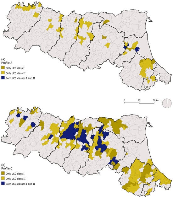
The most critical profiles, A and C, show different degrees of overlap between the two soil classes (Figure 6). Profile A involves one class or the other selectively, with full overlap occurring in only three municipalities. Profile C, by contrast, often appears simultaneously for both classes considered, especially in the central part of the region. Differences can also be observed in the degree to which these profiles occur in relation to municipality type. For class I soils, profile A is more frequent in intermediate municipalities and rural areas, while profile C is concentrated mainly in cities and intermediate municipalities. For class II soils, by contrast, both profiles are more frequent in urbanised contexts, namely cities and intermediate municipalities.
Figure 6.
(a) Profile A; (b) Profile C. Overlap of profiles A and C for LCC classes I and II agricultural soils in Emilia-Romagna municipalities. Source: Author’s elaboration based on data from the Emilia-Romagna Region; see Section 3.
5. Conclusions
The expansion of ground-mounted PV plants in agricultural areas is one of the most evident manifestations of the new energy landscapes produced by decarbonisation policies. Some studies stress that, by converting a small share of agricultural land to energy uses, the RES development targets set by the European Union for 2030 and beyond could be achieved more easily [57]. On closer inspection, however, this is by no means a negligible sacrifice. When these general estimates are translated into specific territorial contexts, they may result in unsustainable pressure on local communities, even leading to forms of energy exploitation driven by exogenous interests. This also fuels the short circuit between two equally crucial objectives on political agendas: on the one hand, accelerating the energy transition, and, on the other, protecting agricultural soil as a resource that should not be wasted and whose quality must be safeguarded. In Italy, the provision of solar belts around industrial and commercial facilities—recognised since 2021 as ope legis suitable areas for ground-mounted PV plants—could further reinforce this structural tension.
Two main findings emerge from our work on the case of Emilia-Romagna. First, it is clear that solar belts intercept, extensively across the region, large agricultural areas free from environmental and landscape constraints. Within the 350 m buffers around industrial and commercial facilities, agriculture is not only clearly present, but there is also a high incidence of class I and class II soils, those with the fewest agronomic limitations. This gives rise to a critical issue: the rules are designed to facilitate the energy transition, but they may potentially lead to the loss of many valuable agricultural soils, which are moreover already under pressure in the “real” geography of ground-mounted PV plants. This stems from a definition of ope legis suitable areas based on predefined-size buffers: it assumes a “flat soil” and uses geometric parameters that are easy to apply, without any reference to the agronomic and pedological characteristics of the soils involved.
The second key finding of the research concerns the different situations of municipalities in terms of the actual pressure (Pci) and potential exposure (Eci) of ground-mounted PV plants on class I and class II soils. Among the different possible combinations, cases A and C should be kept under close watch, as they are the most problematic. In case A, there is a cumulative risk: strong pressure from ground-mounted PV plants on the best soils is already detectable, and the opportunities associated with the presence of solar belts could, in the future, worsen the situation by increasing the level of use of these soils. In case C, by contrast, the risk is diffusive, since the mechanism of solar belts could potentially favour an expansion of ground-mounted PV plants in contexts that have so far remained marginal within regional energy geographies. At present, ground-mounted PV plants are concentrated mainly in the eastern plain, but the centre of gravity could shift towards the central part of the region, where many municipalities with a C profile are located. The key nodes of this “potential” geography are mainly cities and intermediate municipalities, with different emphases depending on the soil class considered. This urban–rural gradient is particularly marked for class II soils, for which differences in both Eci and Pci across DEGURBA groups are statistically significant.
This work has at least three limitations that should be carefully considered. First, it measures potential exposure rather than a certain future transformation, which will depend on the interplay between investors, agricultural holdings, and local administrations, each with their own strategies and priorities. Second, the use of data aggregated at the municipal level is useful for outlining different situations in terms of the actual and potential pressure exerted by ground-mounted PV plants, but it masks the different conditions of individual buffers. Finally, factors such as land cost, proximity to the electricity grid, and other technical and environmental aspects that make sites more or less attractive for ground-mounted PV plants were not considered. It can nevertheless be assumed that the areas surrounding industrial and commercial facilities are generally well positioned in relation to the infrastructure network.
Despite all this, the key finding of the study remains firm: ope legis suitable areas, to which simplified authorisation procedures for ground-mounted PV plants are linked, could entail the potential loss of many agricultural soils, including the most valuable ones, which, according to some authors and as discussed in Section 2.1, should be safeguarded as a priority. This risk could be mitigated through agrivoltaic systems, but it is not entirely eliminated: although they do not come into conflict with agriculture, these systems still modify cultivation, irrigation, and soil management practices, with a strong impact on the landscape as well.
It would be useful to incorporate a pedological assessment into the mechanism of suitable areas, to help protect the highest-quality agricultural soils. Moving in this direction is not easy and, as we have seen, even in Emilia-Romagna, the new regional rules on suitable areas, approved in May 2026, leave the “pedological issue” unresolved. The Emilia-Romagna Region aims to protect certified crops, but these are linked to production methods or historical ties with certain territories, which do not necessarily overlap with the most valuable soils.
With regard to future research directions, it would be useful to consider the belts adjacent to motorways, which are also ope legis suitable for ground-mounted PV plants, so as to understand which agricultural soils are involved and whether there are overlaps with the solar belts. It would also be important to analyse the flow of authorisations for new ground-mounted PV plants, to understand the extent to which they concern ope legis suitable sites. Finally, by broadening the perspective beyond Emilia-Romagna, it would be possible to assess whether selective pressure on the best soils is also present elsewhere, and how this issue is addressed in the various regional regulations.
Funding
This research received no external funding.
Institutional Review Board Statement
Not applicable.
Informed Consent Statement
Not applicable.
Data Availability Statement
The data presented in this study are available on request from the corresponding author.
Acknowledgments
During the preparation of this manuscript, the author used OpenAI’s ChatGPT, version 5.5, to assist with the translation of the manuscript from Italian into English and with language editing. The tool was not used for research design, data collection, GIS processing, data analysis, interpretation of results, or the preparation of tables and figures. The author has reviewed and edited all AI-assisted outputs and takes full responsibility for the content of the published article.
Conflicts of Interest
The author declares no conflicts of interest.
References
- International Renewable Energy Agency (IRENA). Renewable Capacity Statistics 2026; IRENA: Abu Dhabi, United Arab Emirates, 2026. [Google Scholar]
- Kougias, I.; Taylor, N.; Kakoulaki, G.; Jäger-Waldau, A. The role of photovoltaics for the European Green Deal and the recovery plan. Renew. Sustain. Energy Rev. 2021, 144, 111017. [Google Scholar] [CrossRef] [Scilit]
- Cogato, A.; Marinello, F.; Pezzuolo, A. Soil footprint and land-use change to clean energy production: Implications for solar and wind power plants. Land 2023, 12, 1822. [Google Scholar] [CrossRef] [Scilit]
- Lucchi, E.; Adami, J.; Stawinoga, A.E. Social acceptance of photovoltaic systems in heritage buildings and landscapes: Exploring barriers, benefits, drivers, and challenges for technical stakeholders in Northern Italy. Sustain. Energy Technol. Assess. 2023, 60, 103544. [Google Scholar] [CrossRef] [Scilit]
- Pasqualetti, M.J. Social barriers to renewable energy landscapes. Geogr. Rev. 2011, 101, 201–223. [Google Scholar] [CrossRef] [Scilit]
- Calvert, K.E. Measuring and modelling the land-use intensity and land requirements of utility-scale photovoltaic systems in the Canadian province of Ontario. Can. Geogr. 2018, 62, 188–199. [Google Scholar] [CrossRef] [Scilit]
- Ioannidis, R.; Koutsoyiannis, D. A review of land use, visibility and public perception of renewable energy in the context of landscape impact. Appl. Energy 2020, 276, 115367. [Google Scholar] [CrossRef] [Scilit]
- Lamhamedi, B.E.H.; de Vries, W.T. An exploration of the land-(renewable) energy nexus. Land 2022, 11, 767. [Google Scholar] [CrossRef] [Scilit]
- Weselek, A.; Ehmann, A.; Zikeli, S.; Lewandowski, I.; Schindele, S.; Högy, P. Agrophotovoltaic systems: Applications, challenges, and opportunities. A review. Agron. Sustain. Dev. 2019, 39, 35. [Google Scholar] [CrossRef] [Scilit]
- Ghosh, A. Nexus between agriculture and photovoltaics (agrivoltaics, agriphotovoltaics) for sustainable development goal: A review. Sol. Energy 2023, 266, 112146. [Google Scholar] [CrossRef] [Scilit]
- Lazo, J.; Trujillo-Baute, E.; Watts, D. Land-use dilemma: Evaluating the transition from crops to solar PV plants using a real options approach. J. Clean. Prod. 2026, 540, 147468. [Google Scholar] [CrossRef] [Scilit]
- Frolova, M.; Centeri, C.; Benediktsson, K.; Hunziker, M.; Kabai, R.; Scognamiglio, A.; Martinopoulos, G.; Sismani, G.; Brito, P.; Muñoz-Cerón, E.; et al. Effects of renewable energy on landscape in Europe: Comparison of hydro, wind, solar, bio-, geothermal and infrastructure energy landscapes. Hung. Geogr. Bull. 2019, 68, 317–339. [Google Scholar] [CrossRef] [Scilit]
- Trainor, A.M.; McDonald, R.I.; Fargione, J. Energy sprawl is the largest driver of land use change in United States. PLoS ONE 2016, 11, e0162269. [Google Scholar] [CrossRef] [Scilit] [PubMed]
- Cole, B.; Smith, G.; de la Barreda-Bautista, B.; Hamer, A.; Payne, M.; Codd, T.; Johnson, S.C.M.; Chan, L.Y.; Balzter, H. Dynamic landscapes in the UK driven by pressures from energy production and forestry—Results of the CORINE land cover map 2018. Land 2022, 11, 192. [Google Scholar] [CrossRef] [Scilit]
- Klingebiel, A.A.; Montgomery, P.H. Land Capability Classification. USDA Agricultural Handbook 210; U.S. Government Printing Office: Washington, DC, USA, 1961.
- Kiesecker, J.M.; Evans, J.S.; Oakleaf, J.R.; Dropuljić, K.Z.; Vejnović, I.; Rosslowe, C.; Cremona, E.; Bhattacharjee, A.L.; Nagaraju, S.K.; Ortiz, A.; et al. Land use and Europe’s renewable energy transition: Identifying low-conflict areas for wind and solar development. Front. Environ. Sci. 2024, 12, 1355508. [Google Scholar] [CrossRef] [Scilit]
- Song, C.; Guo, Z.; Liu, Z.; Hongyun, Z.; Liu, R.; Zhang, H. Application of photovoltaics on different types of land in China: Opportunities, status and challenges. Renew. Sustain. Energy Rev. 2024, 191, 114146. [Google Scholar] [CrossRef] [Scilit]
- Neesham-McTiernan, T.H.; Randle-Boggis, R.J.; Buckley, A.R.; Hartley, S.E. The spatial potential for agrivoltaics to address energy-agriculture land use conflicts in Great Britain. Appl. Energy 2025, 385, 125527. [Google Scholar] [CrossRef] [Scilit]
- Winikoff, J.B.; Maguire, K.; Tanner, S.J.; Deol, S.; Weilert, T. Cashing out? Farmland quality and the adoption of utility-scale solar energy. Renew. Energy 2026, 259, 125026. [Google Scholar] [CrossRef] [Scilit]
- Bošnjaković, M.; Santa, R.; Crnac, Z.; Bošnjaković, T. Environmental impact of PV power systems. Sustainability 2023, 15, 11888. [Google Scholar] [CrossRef] [Scilit]
- Sistema Nazionale per la Protezione dell’Ambiente (SNPA). Consumo di Suolo, Dinamiche Territoriali e Servizi Ecosistemici. Edizione 2025, Report Ambientali SNPA, 46/2025. Available online: https://www.snpambiente.it/pubblicazioni/report-snpa/consumo-di-suolo-dinamiche-territoriali-e-servizi-ecosistemici-edizione-2025/ (accessed on 4 July 2026).
- Clerici, M.A. Impianti fotovoltaici a terra e occupazione di suoli agricoli di elevata qualità: Il caso dell’Emilia-Romagna. Riv. Geogr. Ital. 2026, in press. [Google Scholar] [CrossRef] [Scilit]
- Ranjgar, B.; Niccolai, A.; Leva, S. Where can solar go? Assessing land availability for PV in Italy under regulatory constraints. Solar 2025, 5, 40. [Google Scholar] [CrossRef] [Scilit]
- Watson, J.J.W.; Hudson, M.D. Regional scale wind farm and solar farm suitability assessment using GIS-assisted multi-criteria evaluation. Landsc. Urban Plan. 2015, 138, 20–31. [Google Scholar] [CrossRef] [Scilit]
- Späth, L. Large-scale photovoltaics? Yes please, but not like this! Insights on different perspectives underlying the trade-off between land use and renewable electricity development. Energy Policy 2018, 122, 429–437. [Google Scholar] [CrossRef] [Scilit]
- Li, S.; Gou, Z. Accepting solar photovoltaic panels in rural landscapes: The tangle among nostalgia, morality, and economic stakes. Land 2023, 12, 1956. [Google Scholar] [CrossRef] [Scilit]
- Delatin Rodrigues, D.; Grasso, M. The resistance to solar energy expansion in Italy: A systemic perspective. Sustain. Sci. 2025, 20, 1329–1342. [Google Scholar] [CrossRef] [Scilit]
- Shao, M.; Han, Z.; Sun, J.; Xiao, C.; Zhang, S.; Zhao, Y. A review of multi-criteria decision making applications for renewable energy site selection. Renew. Energy 2020, 157, 377–403. [Google Scholar] [CrossRef] [Scilit]
- Liang, L.; Wang, X.; Zhang, X.; Jia, X.; Chen, Z.; Zheng, X. A systematic review of photovoltaic power plant site selection approaches: Literature retrieval and analysis method based on ChatGPT and DeepSeek. Energy Rep. 2025, 14, 1993–2014. [Google Scholar] [CrossRef] [Scilit]
- Alami Merrouni, A.; Elwali Elalaoui, F.; Mezrhab, A.; Mezrhab, A.; Ghennioui, A. Large scale PV sites selection by combining GIS and analytical hierarchy process. Case study: Eastern Morocco. Renew. Energy 2018, 119, 863–873. [Google Scholar] [CrossRef] [Scilit]
- Reguera Bueno, G.; Simal Pérez, N.; Cortés-Carmona, M.; Alonso-Montesinos, J. Land use, soiling impact and distance to electrical grid applied to determine the viability of solar photovoltaic systems in the south of Spain. Renew. Energy 2025, 239, 122108. [Google Scholar] [CrossRef] [Scilit]
- Demir, A.; Dinçer, A.E.; Yılmaz, K. A novel method for the site selection of large-scale PV farms by using AHP and GIS: A case study in Izmir, Türkiye. Sol. Energy 2023, 259, 235–245. [Google Scholar] [CrossRef] [Scilit]
- Chai, S.; Kong, F.; Liu, Y.; Liang, M.; Liu, Q. Photovoltaic solar farms site selection through ‘Policy Constraints–Construction Suitability’: A case study of Qilian County, Qinghai. Land 2024, 13, 1420. [Google Scholar] [CrossRef] [Scilit]
- Zhang, Y.; Ren, J.; Pu, Y.; Wang, P. Solar energy potential assessment: A framework to integrate geographic, technological, and economic indices for a potential analysis. Renew. Energy 2020, 149, 577–586. [Google Scholar] [CrossRef] [Scilit]
- Díaz-Cuevas, P.; Haddad, B.; Fernandez-Nunez, M. Energy for the future: Planning and mapping renewable energy. The case of Algeria. Sustain. Energy Technol. Assess. 2021, 47, 101445. [Google Scholar] [CrossRef] [Scilit]
- Sun, L.; Jiang, Y.; Guo, Q.; Ji, L.; Xie, Y.; Qiao, Q.; Huang, G.; Xiao, K. A GIS-based multi-criteria decision making method for the potential assessment and suitable sites selection of PV and CSP plants. Resour. Conserv. Recycl. 2021, 168, 105306. [Google Scholar] [CrossRef] [Scilit]
- Ali, S.; Taweekun, J.; Techato, K.; Waewsak, J.; Gyawali, S. GIS based site suitability assessment for wind and solar farms in Songkhla, Thailand. Renew. Energy 2019, 132, 1360–1372. [Google Scholar] [CrossRef] [Scilit]
- Guaita-Pradas, I.; Marques-Perez, I.; Gallego, A.; Segura, B. Analyzing territory for the sustainable development of solar photovoltaic power using GIS databases. Environ. Monit. Assess. 2019, 191, 764. [Google Scholar] [CrossRef] [Scilit] [PubMed]
- Nguyen, D.-T.; Truong, M.-H.; Phan, D.-T. GIS-based simulation for solar farm site selection in south-central Vietnam. GeoJournal 2022, 87, 3685–3699. [Google Scholar] [CrossRef] [Scilit]
- Doljak, D.; Stanojević, G. Evaluation of natural conditions for site selection of ground-mounted photovoltaic power plants in Serbia. Energy 2017, 127, 291–300. [Google Scholar] [CrossRef] [Scilit]
- Sánchez-Lozano, J.M.; Henggeler Antunes, C.; García-Cascales, M.S.; Dias, L.C. GIS-based photovoltaic solar farms site selection using ELECTRE-TRI: Evaluating the case for Torre Pacheco, Murcia, Southeast of Spain. Renew. Energy 2014, 66, 478–494. [Google Scholar] [CrossRef] [Scilit]
- Kırcalı, Ş.; Selim, S. Site suitability analysis for solar farms using the geographic information system and multi-criteria decision analysis: The case of Antalya, Turkey. Clean Technol. Environ. Policy 2021, 23, 1233–1250. [Google Scholar] [CrossRef] [Scilit]
- Reher, T.; Lavaert, C.; Ottoy, S.; Martens, J.A.; Van Orshoven, J.; Cappelle, J.; Diels, J.; Van de Poel, B. Room for renewables: A GIS-based agrivoltaics site suitability analysis in urbanized landscapes. Agric. Syst. 2025, 224, 104266. [Google Scholar] [CrossRef] [Scilit]
- Gasparini, J.L.G.; Branco, D.A.C.; Szklo, A. Soil suitability and technical-construction criteria for slope classification in agrivoltaic systems. Sol. Energy 2026, 308, 114335. [Google Scholar] [CrossRef] [Scilit]
- Fattoruso, G.; Toscano, D.; Venturo, A.; Scognamiglio, A.; Fabricino, M.; Di Francia, G. A spatial multicriteria analysis for a regional assessment of eligible areas for sustainable agrivoltaic systems in Italy. Sustainability 2024, 16, 911. [Google Scholar] [CrossRef] [Scilit]
- Hernandez, R.R.; Hoffacker, M.K.; Murphy-Mariscal, M.L.; Wu, G.C.; Allen, M.F. Solar energy development impacts on land cover change and protected areas. Proc. Natl. Acad. Sci. USA 2015, 112, 13579–13584. [Google Scholar] [CrossRef] [Scilit] [PubMed]
- Mauro, G.; Lughi, V. Mapping land use impact of photovoltaic farms via crowdsourcing in the Province of Lecce (Southeastern Italy). Sol. Energy 2017, 155, 434–444. [Google Scholar] [CrossRef] [Scilit]
- Barral, M.Á.; Ruíz Díez, A.; Prados, M.-J.; García-Marín, R.; Delicado, A. Renewable energies and land use changes in the South of the Iberian Peninsula: A geographical interpretation of the national energy policies. Bol. Asoc. Geogr. Esp. 2023, 97, 20230259743. [Google Scholar]
- Alves, A.; Gomes, E.; Marques da Costa, E.; Caetano, M. Beyond renewable energy targets: Understanding the land use implications of solar energy facilities in Continental Portugal. Geogr. Sustain. 2026, 7, 100406. [Google Scholar] [CrossRef] [Scilit]
- Jiang, L.; Liu, Y.; Yang, L. Rapid expansion of photovoltaic land in China’s coastal regions: A doubling from 2020 to 2023. Land Use Policy 2026, 160, 107836. [Google Scholar] [CrossRef] [Scilit]
- Sánchez-Pantoja, N.; Vidal, R.; Pastor, M.C. Aesthetic impact of solar energy systems. Renew. Sustain. Energy Rev. 2018, 98, 227–238. [Google Scholar] [CrossRef] [Scilit]
- Rodríguez-Segura, F.J.; Frolova, M. How does society assess the impact of renewable energy in rural inland areas? Comparative analysis between the province of Jaén (Spain) and Somogy county (Hungary). Investig. Geogr. 2023, 80, 193–214. [Google Scholar] [CrossRef] [Scilit]
- Daniele, F.; Pasquini, A.; Clò, S.; Maltese, E. Unburdening regulation: The impact of regulatory simplification on photovoltaic adoption in Italy. Energy Econ. 2024, 129, 106844. [Google Scholar] [CrossRef] [Scilit]
- Antonini, R. Fotovoltaico, nel 2025 in Italia Cala l’installato. 2026. Available online: https://www.renewablematter.eu/fotovoltaico-2025-Italia-cala-installato-crescono-solo-grandi-impianti (accessed on 4 July 2026).
- Gestore Servizi Energetici (GSE). Piattaforma Aree Idonee. Available online: https://areeidonee.gse.it/ (accessed on 4 July 2026).
- Eurostat. Applying the Degree of Urbanisation. A Methodological Manual to Define Cities, Towns and Rural Areas for International Comparisons; Publication Office of the European Union: Luxembourg, 2021. [Google Scholar]
- Perera, M.; Tansini, C. (Eds.) Land for Renewables. Briefing on Spatial Requirements for a Sustainable Energy Transition in Europe; European Environmental Bureau: Brussels, Belgium, 2024. [Google Scholar]

Disclaimer/Publisher’s Note: The statements, opinions and data contained in all publications are solely those of the individual author(s) and contributor(s) and not of MDPI and/or the editor(s). MDPI and/or the editor(s) disclaim responsibility for any injury to people or property resulting from any ideas, methods, instructions or products referred to in the content. |
© 2026 by the author. Licensee MDPI, Basel, Switzerland. This article is an open access article distributed under the terms and conditions of the Creative Commons Attribution (CC BY) license.