


Abstract
The Qi Great Wall is one of China’s earliest surviving linear cultural heritage corridors, and its surrounding rural areas play a dual role in heritage conservation and tourism development. However, the corridor has received limited attention in tourism and rural research, facing challenges of fragmented development. This study focuses on rural areas along the Qi Great Wall and develops a comprehensive analytical framework integrating multidimensional evaluation, obstacle degree analysis, and development typology to assess rural tourism development levels across the 15 corridor sections, identify their major constraints, and formulate differentiated development strategies. The results reveal substantial spatial disparities in rural tourism development, with a general west-to-east decline. Tourism resources constitute the primary constraint, followed by tourism reception facilities, transportation facilities, and infrastructure and public services. The 15 sections are classified into four types, namely strong node led, service quality optimization, destination identity cultivation, and support capacity enhancement, providing a basis for targeted and differentiated interventions. The findings have practical implications for rural tourism planning and coordinated heritage conservation along the Qi Great Wall, and the analytical framework offers methodological insights transferable to other linear cultural heritage corridors.
1. Introduction
Linear cultural heritage refers to heritage systems organized along continuous spatial routes, such as ancient trails, military defense systems, and canals, while incorporating associated settlements, landscapes, and local cultural practices along these routes [1,2,3]. Its defining characteristics include extensive spatial coverage, the integration of continuous linear heritage elements with node-based and clustered heritage resources [4], and close interactions between natural and cultural components. The significance of linear cultural heritage lies in the relationships established among heritage nodes, associated settlements, and surrounding landscapes over time, rather than in individual heritage sites alone [5]. With the evolution of international heritage conservation from site-based preservation toward integrated approaches emphasizing cultural landscapes, heritage networks, community participation, and sustainable development, increasing attention has been directed to the integrated conservation and corridor-scale management of linear cultural heritage [6,7,8]. In 2015, UNESCO incorporated sustainable development into the implementation framework of the World Heritage Convention [9], emphasizing that heritage conservation should be coordinated with environmental sustainability, inclusive social development, and economic development. In 2022, ICOMOS released the International Charter for Cultural Heritage Tourism [10], which further broadened the scope of heritage conservation by incorporating natural and cultural landscapes, community well-being, and responsible tourism into heritage conservation and tourism management frameworks. The Charter emphasizes that heritage conservation should focus not only on safeguarding heritage assets themselves but also on maintaining the human–environment relationships and social systems that underpin them. In recent years, China has strengthened cross-regional coordination, integrated conservation, and corridor-based management of linear cultural heritage [11,12,13]. These approaches have been applied in the development of National Cultural Parks, including the Great Wall, Grand Canal, and Long March National Cultural Parks [14,15]. The Great Wall is China’s largest linear cultural heritage corridor, extending across vast rural areas. Villages along the Wall are an integral part of the Great Wall heritage system and provide an important setting for the continuity of local culture, residents’ everyday life, and heritage activation and adaptive use [16,17]. Heritage conservation without the social and economic development of surrounding rural communities is unlikely to support the living transmission of cultural heritage [18]. Therefore, integrating heritage conservation into rural development has become an important pathway for sustaining linear cultural heritage and promoting the sustainable development of surrounding areas [19,20].
Built during the pre-Qin period, the Qi Great Wall is the earliest surviving linear cultural heritage in China with a military defensive function. It represents a distinctive component of the Great Wall system, with strong regional and cultural characteristics, and constitutes an important linear cultural corridor in Shandong Province [21]. Stretching across seven cities and 17 counties on the Shandong Peninsula, the Qi Great Wall links more than 500 villages along its route and follows a winding course that closely conforms to the mountainous terrain [22]. With the ongoing development of the Great Wall National Cultural Park (Shandong Section) and the Qi Great Wall Scenic Corridor, rural tourism has become an important means of promoting rural revitalization and heritage activation in communities along the corridor [23,24]. However, rural tourism development along the Qi Great Wall still faces several challenges, including insufficient development of cultural resources, homogenized tourism products, and fragmented spatial organization [25,26]. Tensions between heritage conservation and tourism development also persist [27], limiting the effective use of heritage resources and the sustainable revitalization of rural communities along the corridor. These challenges highlight the need to examine the spatial pattern of rural tourism development along the Qi Great Wall, identify the key limiting indicators, and explain the mechanisms behind these development constraints.
A substantial body of research has examined the conservation and adaptive use of linear cultural heritage, the interpretation of Great Wall heritage values, and rural tourism development [28,29]. In terms of research subjects, international studies have examined a wide range of cultural routes and heritage corridors, including canals, pilgrimage routes, industrial heritage routes, and transregional cultural corridors [30,31,32,33]. Linear heritage is generally understood as a complex cultural space shaped by heritage assets, surrounding environments, historical processes, social interactions, and spatial networks [34,35,36]. In China, research has mainly focused on large-scale linear heritage, such as the Grand Canal, the Great Wall, the Silk Road, and the Ancient Tea Horse Road [37,38], emphasizing its role in overcoming the limitations of site-based conservation and linking heritage conservation with regional development along the corridor. In recent years, alongside the development of the Great Wall National Cultural Park and increasing cultural-tourism integration, Great Wall research has expanded from the conservation of physical remains, such as walls and beacon towers, to broader issues concerning settlements, historic environments, frontier culture, and coordinated regional development [39,40]. In terms of research themes, international studies place greater emphasis on the integrated conservation, cross-regional governance, and sustainable tourism development of linear cultural heritage [41], with particular attention to the multiple values of heritage routes in cultural transmission and regional development. In China, research has gradually shifted from conceptual exploration and heritage identification toward spatial organization, coordinated conservation and use, and planning governance. Studies have emphasized spatial approaches such as heritage corridors, cultural corridors, and National Cultural Parks to integrate dispersed heritage resources, maintain historical continuity, and develop regional cultural tourism networks [42]. Methods such as social network analysis [43], the minimum cumulative resistance model [44,45], and circuit theory [46] have also been increasingly applied to heritage corridor identification, spatial connectivity assessment, and the optimization of conservation and use patterns.
Existing studies have laid a solid foundation for the conservation of linear cultural heritage, the interpretation of Great Wall heritage values, and rural tourism development. However, several gaps remain. First, Great Wall research has largely concentrated on well-known and relatively well-preserved sections, particularly the Ming Great Wall [39,47], while the Qi Great Wall has received far less attention. Studies that jointly examine heritage resources, rural settlements, and tourism support conditions within a common spatial framework are especially limited. Second, research on cultural heritage corridors has mainly addressed corridor identification and approaches to conservation and use [48,49], with less attention to how such corridors influence rural development or why development constraints vary among different sections. Methodologically, quantitative assessment of these constraints and their underlying causes also remain limited. A systematic approach is therefore needed to identify intra-corridor disparities and diagnose key constraints to support differentiated rural tourism development along linear cultural heritage corridors.
This study focuses on rural areas along the Qi Great Wall and aims to address three research questions: (1) What are the spatial patterns of rural tourism development along the Qi Great Wall? (2) What are the major development constraints, and how do they vary across corridor sections? (3) How can differentiated development strategies be formulated based on these spatial patterns and constraints? To address these questions, the corridor is divided into 15 sections, and a comprehensive analytical framework integrating multidimensional evaluation, obstacle degree analysis, and development typology is developed to assess rural tourism development levels, identify major constraints, and formulate differentiated strategies. Unlike destination-level assessments that focus primarily on individual villages or attractions, the corridor-scale perspective enables comparison among interconnected sections and reveals intra-corridor differences in development levels, constraints, and development needs. At the case-study level, this study presents the first systematic corridor-scale assessment of rural tourism development along the Qi Great Wall, offering practical implications for rural tourism planning and coordinated heritage conservation along the corridor. More broadly, the analytical framework could serve as a methodological reference for research on other linear cultural heritage corridors.
2. Materials and Methods
2.1. Study Area
The Qi Great Wall is an important component of the Great Wall World Cultural Heritage system. Constructed beginning in the Spring and Autumn period (7 century B.C.), it is the earliest surviving ancient Great Wall in China supported by identifiable archeological remains. The Qi Great Wall extends approximately 641 km from Guangli Village, Xiaoli Subdistrict, Changqing District, Jinan City, in the west, to Yujiahe Village, Huangdao District, Qingdao City, in the east (Figure 1). The Qi Great Wall extends across seven cities—Jinan, Tai’an, Zibo, Weifang, Linyi, Rizhao, and Qingdao—and 17 county-level administrative units, connecting more than 500 administrative villages along its route. According to the official approval issued by the National Cultural Heritage Administration on the identification of the Great Wall in Shandong Province, 260 heritage sites have been identified along the Qi Great Wall, including 243 wall sections, one trench, eight passes and forts, and eight beacon towers, forming a relatively complete heritage system. These heritage sites are distributed continuously along the Qi Great Wall and interact closely with surrounding villages, mountainous landscapes, and regional transportation networks. This integrated spatial structure forms a distinctive linear heritage landscape and provides an appropriate setting for examining the coordination between heritage conservation, rural tourism, and regional development.
Figure 1.
Location of the Qi Great Wall in China: (a) Location relative to Great Walls constructed in different historical periods; (b) Location in Shandong Province.
This study focused on areas spatially associated with the Qi Great Wall heritage. Drawing on previous studies [50,51,52] and considering the spatial characteristics of the Qi Great Wall, a 5 km buffer on both sides was adopted as an operational analytical boundary to delineate the initial study area. As this study specifically examines rural tourism, approximately 230 km2 of highly urbanized towns and subdistricts within Boshan District and Huangdao District were excluded according to their administrative boundaries to minimize their influence on the assessment of rural tourism development. The final study area covers 4786.78 km2 and includes 2271 administrative villages.
Eighteen nodes were selected to support the assessment of rural tourism development and the segmentation of the linear heritage corridor. Node selection considered administrative boundaries, the distribution of major passes, and key tourism sites. The selected nodes are Guangli Village, Xuanzhuang Village, Zhangjiahuayu Village, Yujiazhuang Village, Matao Village, Qixingtai, Jinyang Pass, Huangshi Pass, Qingshi Pass, Yaojiayu Village, Chengzi Village, Dongyu Village, Muling Pass, Taijiaya Village, Dongguan Town, Dama’an Village, Shijiakuang Village, and Yujiahe Village. These nodes were then used to divide the study area into 15 sections, which were sequentially coded as S1–S15 from west to east along the Qi Great Wall (Figure 2). To improve readability and ensure consistency across the manuscript, these section codes are used in the subsequent maps and analyses, while the corresponding nodes and names of each section are provided in Table 1.
Figure 2.
Nodes and corridor sections of the Qi Great Wall.
Table 1.
Correspondence between section codes and defining nodes along the Qi Great Wall corridor.
2.2. Research Methods
2.2.1. Evaluation Model for Rural Tourism Development Along the Qi Great Wall
Destination competitiveness theory suggests that destination competitiveness is influenced by core resources and attractors, supporting factors and resources, destination management, destination policy, planning and development, and qualifying and amplifying determinants [53,54]. Based on this theoretical framework and considering the heritage resource characteristics, linear spatial structure, and tourism development conditions of the Qi Great Wall [55,56], this study developed an evaluation framework comprising four dimensions: tourism resources, tourism reception facilities, transportation facilities, and infrastructure and public services. These dimensions represent four essential aspects of rural tourism development along a linear cultural heritage corridor: tourism resources provide the basis for tourism attraction and heritage-based experiences; reception facilities reflect the capacity to transform tourism demand into local services and benefits; transportation facilities determine accessibility and connectivity among dispersed heritage sites, villages, and tourism nodes; and infrastructure and public services provide the basic support for tourism activities and rural communities.
To further operationalize this framework, drawing on the indicators adopted in relevant studies [57,58] and considering the specific characteristics of the Qi Great Wall corridor, 22 indicators were selected to capture these dimensions and assess rural tourism development along the corridor (Table 2). The tourism resources dimension comprises Great Wall remains, passes and defensive remains, A-level tourist attractions, rural tourism destinations, cultural resources and cultural services. The tourism reception facilities dimension covers catering, accommodation, shopping, entertainment, and tourism management services. The transportation facilities dimension includes road networks, transportation hubs, high-grade roads, fuel and charging stations, and parking facilities. The infrastructure and public services dimension covers communication, medical care, education, environmental sanitation, daily-life services, and security facilities.
Table 2.
Evaluation indicator system for rural tourism development along the Qi Great Wall.
2.2.2. Comprehensive Evaluation Model
To reduce the influence of differences in section size, all indicators were converted into density measures before evaluation. The 22 positive indicators were normalized using the min–max normalization method:
where x’ij represents the normalized value of indicator j for sample i, and xij represents the original value. max(xj) and min(xj) represent the maximum and minimum values of indicator j, respectively.
A combined AHP-entropy weighting method was adopted to determine indicator weights. The weights of the four dimensions were determined using the Analytic Hierarchy Process (AHP) [59]. Experts from Shandong Jianzhu University, the Department of Culture and Tourism of Shandong Province, Shandong Urban and Rural Planning and Design Research Institute, as well as practitioners in rural governance and tourism development were invited to participate in the evaluation. Their professional backgrounds covered urban and rural planning, tourism management, cultural heritage conservation, and public administration. Based on their assessments of the relative importance of the four dimensions, pairwise comparison matrices were constructed. The dimension weights were then derived using the AHP, and the consistency of the judgment matrices passed the consistency test, with a consistency ratio (CR) of 0.0225 (<0.10). The entropy weighting method was subsequently applied to determine the weights of individual indicators according to their variation across the 15 sections [60,61]. Finally, the AHP-derived weight of each dimension was combined with the entropy-based weight of each indicator within that dimension to obtain the final weights of the 22 indicators, as presented in Table 3.
where Wj denotes the final weight of indicator j, Ai denotes the AHP-derived weight of dimension i to which indicator j belongs, and Ej denotes the entropy-based weight of indicator j within that dimension.
Table 3.
Weights of indicators used to evaluate rural tourism development along the Qi Great Wall.
The linear weighted comprehensive evaluation model was applied to calculate the rural tourism development level of each section along the Qi Great Wall. The calculation formula is as follows:
where Si represents the comprehensive development score of evaluation unit i; Wj represents the combined weight of indicator j; X’ij represents the normalized value of indicator j for evaluation unit i; and n represents the total number of indicators, which is 22 in this study.
To further examine the spatial differentiation of rural tourism development along the Qi Great Wall, the natural breaks method was used to classify the comprehensive scores Si into five levels. The spatial distribution was visualized using ArcGIS 10.8.
2.2.3. Obstacle Degree Model
To identify the key constraints affecting rural tourism development along the Qi Great Wall, the obstacle degree model was applied to evaluate the limiting effects of individual indicators. This model integrates indicator weights and deviation degrees to quantify the relative contribution of each factor to overall development constraints. The calculations were as follows.
First, the factor contribution is determined:
where Fj is the weight of indicator j, wj is the weight of the criterion dimension to which the indicator belongs, and Pj is the indicator weight within that dimension.
Second, indicator deviation, defined as the distance between an indicator and its ideal value, is calculated as:
where is the deviation of indicator j and is its normalized value.
Third, the obstacle degree of each indicator is calculated as:
where Oij is the obstacle degree of indicator j; a larger value indicates a stronger constraint on coordinated development.
Finally, the obstacle degree of each dimension was calculated as:
2.3. Data Sources
The datasets used in this study mainly include POI data, tourism-related village data, and spatial vector data. POI data were obtained through the Amap Web Service API (https://lbs.amap.com/api/webservice/guide/api-advanced/search, accessed on 31 December 2025) and included tourism attractions, catering facilities, shopping facilities, sports and recreational facilities, and other public service facilities. The obtained coordinates were transformed into the WGS 1984 coordinate system for subsequent spatial analysis. Tourism-related village data include historical and cultural villages, key rural tourism villages, and traditional villages. These data were collected from publicly available lists released by the Shandong Provincial Department of Culture and Tourism and the Department of Housing and Urban–Rural Development, with all lists published up to 31 December 2025 included in the dataset. Spatial vector data include the Qi Great Wall route, transportation networks, and river systems. The route of the Qi Great Wall was extracted from The Qi Great Wall edited by Zongyuan Lu and further refined using topographic conditions and official government documents. The vector dataset was generated in ArcMap 10.8. The distribution data of Great Wall remains and defensive heritage sites were obtained from The Qi Great Wall and relevant provincial and municipal government websites. Road network and river system data were obtained from the OpenStreetMap (OSM) open-source platform (https://www.openstreetmap.org, accessed on 31 December 2025). All datasets were compiled to the end of 2025 to ensure temporal consistency.
3. Results and Analysis
3.1. Spatial Patterns of Rural Tourism Development
3.1.1. Spatial Pattern of Comprehensive Development
The results revealed significant spatial heterogeneity in rural tourism development along the Qi Great Wall, with an overall limited development level and distinct differences among sections (Figure 3). Specifically, higher development levels were mainly concentrated in the western sections, while the eastern sections generally showed lower development levels, accompanied by an interspersed distribution of high- and low-development sections. The Qingshi Pass–Yaojiayu–Chengzi section (S8) exhibited the highest development level and represented the primary tourism development core along the corridor. In contrast, the Chengzi–Dongyu section (S9), Muling Pass–Taijiaya–Dongguan section (S12), and Dama’an–Shijiakuang section (S14) showed the lowest development levels and constituted the main lower-development sections. These findings suggest that rural tourism development along the Qi Great Wall remains spatially uneven, with insufficient continuity among different sections.
Figure 3.
Spatial pattern of rural tourism development.
3.1.2. Spatial Pattern Across Dimensions
- (1)
- Tourism Resources
The tourism resources along the Qi Great Wall exhibited an overall west-to-east decline, with higher resource levels concentrated in the western sections (Figure 4). High-value sections were mainly distributed in the Guangli–Xuanzhuang section (S1), Zhangjiahuayu–Matao section (S3), Qingshi Pass–Yaojiayu–Chengzi section (S8), Qixingtai–Jinyang Pass section (S5), Jinyang Pass–Huangshi Pass section (S6), and Huangshi Pass–Yaojiayu section (S7).
Figure 4.
Spatial pattern of tourism resources.
Based on resource composition, the high-value sections can be further classified into two types: heritage-based resource sections and compound resource sections. Heritage-based resource sections are primarily characterized by well-preserved military heritage remains, including continuous walls, passes, and beacon towers. Typical examples include the Zhangjiahuayu–Matao section (S3), Qixingtai–Jinyang Pass section (S5), and Jinyang Pass–Huangshi Pass section (S6). These sections exhibit high continuity of Wall remains, strong heritage recognition, integrated military defense landscapes, and prominent historical and cultural values. For example, the Jinyang Pass–Huangshi Pass section (S6) contains 7742 m of heritage remains, accounting for 26% of all sections, with a heritage density of 41.62 m/km2, far exceeding the average density of 8.74 m/km2 across all sections. The Qingshi Pass–Yaojiayu–Chengzi section (S8) represents a typical compound resource section. It contains 5 A-level tourist attractions, 15 traditional villages, and 30 cultural service facilities (Figure 5), with a wall-remain density of only 4.82 m/km2, forming a diversified resource structure integrating Great Wall heritage, landscape ecology, public cultural facilities, and rural tourism experiences. Low-value sections were mainly distributed in the Xuanzhuang–Zhangjiahuayu–Yujiazhuang section (S2), Matao–Qixingtai section (S4), and Dama’an–Shijiakuang section (S14). These areas have limited Great Wall remains, tourist attractions, and rural tourism resources. Taking the Dama’an–Shijiakuang section (S14) as an example, the density of Great Wall remains is only 0.39 m/km2, with no identified rural tourism or cultural resources distributed within the section. Therefore, this section represents the area with the most significant resource constraints and the weakest foundation for tourism development along the Qi Great Wall.
Figure 5.
Spatial distribution of various tourism resources.
- (2)
- Tourism Reception Facilities
The spatial distribution of tourism reception facilities along the Qi Great Wall exhibited higher levels in the western sections than in the eastern sections (Figure 6).
Figure 6.
Spatial pattern of tourism reception facilities.
High-value sections were mainly distributed in the Qingshi Pass–Yaojiayu–Chengzi section (S8), Zhangjiahuayu–Matao section (S3), Huangshi Pass–Yaojiayu section (S7), Dongguan–Dama’an section (S13), and Shijiakuang–Yujiahe section (S15). Among these sections, the Qingshi Pass–Yaojiayu-Chengzi section (S8) showed significant clustering across all five types of facilities, forming the most concentrated tourism service area and the major reception hub along the Qi Great Wall. Benefiting from the well-established rural tourism foundation of Boshan District, this section demonstrated prominent advantages in catering, shopping, and entertainment facilities, with 1353, 2412, and 227 facilities, respectively (Figure 7). The corresponding densities reached 4.35, 7.75, and 0.73 facilities/km2, which were approximately 22.8, and 10 times higher than those of the Dama’an–Shijiakuang section (S14), which had the lowest level of comprehensive reception facilities. These advantages enabled the section to provide integrated support for visitor reception, consumption, and immersive tourism experiences, representing one of the few sections along the corridor with a relatively systematic and large-scale tourism service layout. In comparison, other high-value sections, including Zhangjiahuayu–Matao (S3), Huangshi Pass–Yaojiayu (S7), Dongguan–Dama’an (S13), and Shijiakuang–Yujiahe (S15), mainly exhibited localized high-value clusters formed around scenic attractions, township centers, or individual service nodes. These sections showed partial concentration of specific facilities, such as accommodation and shopping facilities, but had not yet developed a systematic and networked tourism reception system. Consequently, their overall service capacity and comprehensive tourism functions remained relatively limited.
Figure 7.
Spatial distribution of various tourism reception facilities: (a) Catering services, (b) Accommodation facilities, (c) Shopping facilities, (d) Entertainment facilities, (e) Tourism management services.
- (3)
- Transportation Facilities
The transportation facilities along the Qi Great Wall vary considerably across regions, with better conditions at both ends and in the central section (Figure 8). High-performing areas were mainly concentrated in Changqing District of Jinan at the western end, Boshan District of Zibo in the middle section, and the West Coast New Area of Qingdao at the eastern end.
Figure 8.
Spatial pattern of transportation facilities.
From the perspective of the spatial relationship between transportation networks and the Qi Great Wall (Figure 9), The Qi Great Wall is located predominantly in mountainous areas, where the road network and transportation service facilities, such as fuel and charging stations, are relatively sparse, with densities of only 0.77 km/km2 and 0.047 facilities/km2, respectively. Although the corridor is crossed by 17 north–south expressways and 5 east–west expressways, with 71 expressway entrances and exits, the local road network within the corridor remains relatively limited, constraining accessibility between rural nodes and the continuous movement of visitors across different sections. The Qingshi Pass–Yaojiayu–Chengzi section (S8) demonstrated the strongest transportation support capacity along the corridor. It contains 11 transportation hubs (expressway exits), with a high-grade road density of 0.3599 km/km2, and shows significant advantages in parking and energy supply facilities. Meanwhile, the development of a mature scenic corridor has further strengthened spatial connections among heritage sites, tourist attractions, and traditional villages, enhancing the capacity of this section to organize tourism flows. In addition to the central core section, the Guangli–Xuanzhuang section (S1) at the western end and the Shijiakuang–Yujiahe section (S15) at the eastern end also exhibited relatively favorable transportation conditions. The Guangli–Xuanzhuang section (S1) is located in gently undulating piedmont terrain and has historically served as an important transportation corridor connecting the Central Plains and the Qilu region. The Shijiakuang–Yujiahe section (S15) is located in the coastal hilly area of the West Coast New Area. Both sections lack significant terrain barriers and are therefore suitable for the development of major transportation routes. Moreover, their proximity to urban areas enables them to benefit from transportation spillover effects. In contrast, several connecting sections showed limited transportation support capacity. Among these sections, the Muling Pass–Taijiaya-Dongguan section (S12) exhibited the weakest transportation support capacity, with a high-grade road density of only 0.0039 km/km2 and no expressway entrances or exits, indicating significant limitations in external transportation accessibility.
Figure 9.
Spatial distribution of various transportation facilities.
- (4)
- Infrastructure and public services
The infrastructure and public services along the Qi Great Wall exhibited an overall low development level, with a prominent central section and an interspersed distribution of high- and low-value sections (Figure 10). The spatial distribution of infrastructure and public services was closely associated with population concentration and village-town service systems. These facilities primarily serve local residents, while their continuous support for tourism activities along the corridor remains relatively insufficient.
Figure 10.
Development level of infrastructure and public services.
Among all sections, the Qingshi Pass–Yaojiayu–Chengzi section (S8) formed the most prominent comprehensive support core along the corridor. Benefiting from the relatively well-developed urban and public service system of Boshan District, this section showed balanced provision of medical, communication, daily service, and security facilities. These facilities not only meet local residents’ daily needs but also provide stable support for visitor services, emergency response, and corridor operation. For example, the density of medical facilities reached 1.5608 facilities/km2, approximately 12.8 times that of the Matao–Qixingtai section (S4). The density of security facilities reached 0.1028 facilities/km2, approximately 12.3 times that of the Chengzi–Dongyu section (S9), demonstrating significant advantages in comprehensive support capacity. The Shijiakuang–Yujiahe (S15) section and Dongguan–Dama’an section (S13) constituted secondary high-value areas of infrastructure and public services in the eastern part of the corridor. These advantages were mainly derived from township service centers and the surrounding urban public service systems. The Shijiakuang–Yujiahe section (S15) achieved a daily service facility density of 0.2295 facilities/km2, second only to the central core section, and also showed relatively high levels of medical and educational facilities. The Dongguan–Dama’an section (S13) performed relatively well across multiple indicators, including communication, medical, educational, daily service, and security facilities. Low-value sections were mainly concentrated in mountainous connecting sections and transitional areas of the corridor. Sections such as Chengzi–Dongyu (S9), Matao–Qixingtai (S4), and Dama’an–Shijiakuang section (S14) showed insufficient provision of basic support facilities, particularly in communication, security, daily services, and environmental sanitation. Among them, the Dama’an–Shijiakuang section (S14) had a daily service facility density of only 0.0271 facilities/km2, approximately one-tenth that of the Qingshi Pass–Yaojiayu-Chengzi section (S8). The limited provision of basic services constrains the ability of these sections to support continuous tourist movement along the corridor (Figure 11).
Figure 11.
Spatial distribution of various infrastructure and public services: (a) Communication facilities, (b) Medical facilities, (c) Educational facilities, (d) Environmental sanitation, (e) Daily-life service facilities, (f) Security facilities.
3.2. Sustainability Constraints
3.2.1. Obstacle Degrees of Individual Indicators
The average obstacle degrees of the four dimensions were ranked as follows: tourism resources (0.3264) > tourism reception facilities (0.2497) > transportation facilities (0.2170) > infrastructure and public services (0.2069) (Figure 12a). This indicates that the major constraints on rural tourism development along the Qi Great Wall are primarily associated with heritage and cultural resource support and tourism service capacity, whereas transportation facilities and infrastructure and public services show relatively lower levels of constraint.
Figure 12.
Obstacle degrees of dimensions and indicators for rural tourism development along the Qi Great Wall. Numbers in parentheses indicate the overall rank of the 22 indicators by mean obstacle degree.
At the indicator level (Figure 12b), among the 22 indicators, the five indicators with the highest average obstacle degrees were cultural resources (0.0972), Great Wall remains (0.0782), catering services (0.0766), shopping facilities (0.0723), and parking facilities (0.0656). Together, these five indicators accounted for approximately 39.0% of the total obstacle contribution. When extended to the top ten indicators, their cumulative contribution increased to approximately 64.9%, indicating that a limited number of key indicators constitute the primary constraints affecting rural tourism development along the corridor. Within each dimension, constraints in tourism resources were mainly concentrated in cultural resources and Great Wall remains, which ranked first and second among all indicators, respectively. In contrast, tourist attractions showed the lowest obstacle degree (0.0162, ranked 22nd), suggesting that resource-related constraints mainly reflect differences in heritage resources and local cultural resource support rather than the availability of tourist attractions. For tourism reception facilities, constraints were mainly associated with catering services and shopping facilities, ranking third and fourth among all indicators, while accommodation facilities showed a relatively low obstacle degree (0.0166). For transportation facilities, parking facilities (0.0656) represented the largest constraint, followed by fuel stations and charging facilities and transportation hubs. Meanwhile, road networks and high-grade roads showed relatively lower obstacle degrees, indicating that transportation constraints are mainly related to tourist parking, transfer, and supporting services rather than basic accessibility. Infrastructure and public services exhibited the lowest overall obstacle degree, among which medical facilities (0.0529) showed relatively higher constraints, while other indicators such as environmental sanitation, communication, and education contributed relatively little.
3.2.2. Spatial Differentiation of Obstacle Indicators
The spatial distribution of obstacle degrees demonstrated significant heterogeneity among different sections of the Qi Great Wall corridor (Figure 13). Overall, tourism resources represented the most widespread dominant constraint. Among the 15 sections, tourism resources were the primary obstacle dimension in 11 sections, while tourism reception facilities were the dominant constraint in the remaining four sections. The sections primarily constrained by tourism reception facilities were mainly located in the western part of the corridor, including the Guangli–Xuanzhuang section (S1), Zhangjiahuayu–Matao section (S3), Qixingtai–Jinyang Pass section (S5), and Jinyang Pass–Huangshi Pass section (S6).
Figure 13.
Spatial differentiation heatmap of obstacle indicators across sections.
The relative contributions of different obstacle dimensions varied substantially among sections (Figure 14). Tourism resource constraints exhibited the greatest spatial differentiation, with obstacle degrees ranging from 0.21 to 0.39 in most sections. However, the Qingshi Pass–Yaojiayu–Chengzi section (S8) reached an extremely high value of 0.7737, forming a significant outlier. Although this section has relatively favorable development conditions, insufficient activation and value transformation of tourism resources remain prominent constraints. This reflects a relative constraint characterized by strong existing development foundations but limited resource utilization efficiency, which restricts further improvement toward high-quality development. The spatial differentiation of tourism reception facility constraints was weaker than that of tourism resources. Except for slight differences between sections with strong advantages and those with evident deficiencies, most sections showed relatively stable obstacle degrees ranging from 0.24 to 0.29, indicating a more concentrated distribution. The obstacle degrees of transportation facilities and infrastructure and public services remained relatively low, mainly ranging from 0.15 to 0.27 and 0.08 to 0.26, respectively. Both dimensions showed smaller variations among sections and more balanced spatial distributions.
Figure 14.
Differences in four-dimensional obstacle degrees of rural tourism development.
4. Discussion
4.1. Mechanisms Underlying the Uneven Spatial Pattern of Rural Tourism Development
Rural tourism development along the Qi Great Wall exhibits substantial spatial heterogeneity. The 15 sections differ not only in their overall development levels but also in their dominant constraints, reflecting the combined effects of heritage resource activation capacity, tourism service agglomeration, terrain-induced accessibility constraints, differentiated public service allocation, and cross-regional governance coordination. Similar spatial disparities and the combined influence of multiple factors have also been observed in other linear cultural heritage corridors, such as the Silk Road [62,63]. Among these mechanisms, natural geographical conditions and heritage resource activation capacity establish the fundamental differences in tourism development potential, while market-oriented concentration of tourism reception facilities further reinforces the polarization of tourism nodes. Meanwhile, urban-oriented public service allocation and insufficient coordination under fragmented administrative governance constrain the diffusion of tourism resources, services, and development benefits from core nodes to surrounding villages and adjacent sections. Through their interrelated and mutually reinforcing effects, these factors collectively contribute to a spatial pattern characterized by western advantages, node concentration, and insufficient corridor connectivity (Figure 15).
Figure 15.
Mechanisms Underlying the Uneven Spatial Pattern of Rural Tourism Development along the Qi Great Wall.
4.1.1. Heritage Resource Activation and Utilization
The spatial differentiation of rural tourism development along the Qi Great Wall is initially influenced by differences in heritage resource endowment and its activation capacity. Due to the linear distribution and spatial dispersion of the Qi Great Wall heritage system, different sections vary considerably in terms of Great Wall remains, defensive heritage sites, and historical cultural resources. The transformation of heritage resource advantages into tourism development advantages largely depends on whether heritage assets can be transformed from static conservation objects into tourism products with display, experiential, and consumption values [64]. Some sections, such as the Muling Pass–Dongguan section (S11), possess relatively rich cultural heritage resources; however, insufficient heritage interpretation systems, cultural experience activities, tourism product development, and route organization have hindered the effective connection between heritage resources and rural tourism demands. Consequently, resource advantages have been difficult to translate into stable visitor attraction and tourism benefits. Meanwhile, limited visitor stays and low tourism consumption reduce local stakeholders’ incentives to invest in heritage conservation, activation, and tourism development. Over time, insufficient investment further constrains the transformation of heritage resources into tourism products, weakening visitor attraction and reinforcing a self-reinforcing cycle of underutilized heritage resources and limited tourism development. Therefore, the mismatch between heritage resource endowment and tourism development levels in some sections of the Qi Great Wall indicates that the capacity to transform heritage values into tourism values and broader development benefits represents an important endogenous mechanism shaping the spatial differentiation of rural tourism development.
4.1.2. Node Agglomeration of Tourism Services
Tourism service facilities, including catering, accommodation, shopping, and entertainment facilities, are strongly driven by market demand. Their spatial distribution tends to exhibit node-based agglomeration associated with visitor flows, consumption demand, and tourism development intensity [65,66]. This agglomeration effect is particularly evident in sections with relatively mature tourism development conditions. For example, the Qingshi Pass–Yaojiayu–Chengzi section (S8) benefits from the established Qi Great Wall scenic corridor, which connects the Fengmendao Pass heritage site, Hongye Shiyan scenic area, Zhenmenyu Tianchi, and multiple traditional villages. The integration of tourism resources and improved accessibility has created favorable conditions for tourism service development. Among these villages, Xixiang Village, located near major attractions such as Zhenmenyu, receives substantial visitor flows and generates strong consumption demand. As a result, it is more likely to attract investment in accommodation, catering, and shopping facilities. This process generates a self-reinforcing cycle in which increasing visitor flows stimulate tourism facility investment, while improved services further enhance the attractiveness of the node. In contrast, some villages within the same section show weaker tourism market influence and lower levels of service facility agglomeration. For example, Shanwangzhuang Village remains largely dependent on traditional agricultural activities and local production systems. The limited market incentives for tourism-related investment constrain the development of accommodation, catering, and shopping facilities, reducing visitor stays and consumption potential. This situation leads to a vicious cycle in which weak visitor flows constrain further tourism service investment, while limited facilities continue to reduce the attractiveness of these villages. This demand-driven agglomeration mechanism gradually concentrates tourism services in a limited number of advantageous nodes and generates differentiated development patterns around transportation corridors, scenic area entrances, and urban centers. Therefore, disparities in tourism reception facilities reflect the uneven development of rural tourism and further strengthen the concentration of tourism functions in core nodes, resulting in a spatial structure characterized by several high-performing nodes and numerous villages with moderate development levels along the Qi Great Wall.
4.1.3. Terrain-Induced Accessibility Differentiation
The spatial distribution of the Qi Great Wall is closely associated with mountainous terrain, as many sections were constructed along ridges, passes, and other strategically important locations. This terrain–heritage relationship has also shaped the accessibility conditions of surrounding rural areas. In mountainous sections, complex topography increases the difficulty of road construction, parking provision, and tourism transportation organization, thereby limiting connections between heritage sites and nearby villages. These accessibility constraints affect visitors’ travel decisions and the possibility of integrating multiple destinations into a continuous tourism route. Sections that require longer travel time or higher transportation costs are less likely to attract sustained visitor flows and tourism investment. In contrast, areas with favorable accessibility conditions can benefit from existing road networks and urban transportation systems, while also providing better conditions for the development of supporting services such as parking, catering, and accommodation. These advantages further strengthen their connections with surrounding attractions and settlements. Therefore, terrain-related accessibility differences contribute to uneven tourism development along the Qi Great Wall. Sections with relatively favorable terrain and transportation conditions are more likely to develop into tourism nodes with stronger service capacity, whereas mountainous sections with limited accessibility tend to face greater constraints in attracting visitors and sustaining tourism activities.
4.1.4. Urban–Rural Differentiation in Infrastructure and Public Service Allocation
Infrastructure and public services provide essential support for the sustainable development of rural tourism beyond tourism-specific facilities. However, their spatial allocation still shows evident urban–rural disparities. In recent years, rural development initiatives, including new rural construction, beautiful countryside programs, and rural revitalization strategies, have improved the coverage of communication, sanitation, education, and basic healthcare services in rural areas. Nevertheless, the distribution of infrastructure and public services remains strongly influenced by population size, service demand, and operational efficiency, resulting in a greater concentration of comprehensive services in county centers and major towns. This allocation pattern has produced a spatial structure in which basic services are relatively widespread, while higher-level public services remain concentrated in urban and township nodes. For example, areas surrounding Boshan urban district and township centers such as Dongguan have developed stronger comprehensive service capacities based on relatively mature public service systems, providing certain support to surrounding villages. In contrast, mountainous connecting sections located farther from urban centers mainly maintain basic living services, with limited capacity to support visitor services, emergency response, and continuous tourism activities. Such urban-oriented public service allocation enables some tourism nodes along the Qi Great Wall to benefit from nearby urban service systems, whereas remote villages face insufficient infrastructure and public service support, limiting their ability to sustain tourism activities. For a linear cultural heritage corridor, rural tourism development depends not only on the service capacity of individual villages but also on continuous and interconnected support systems along the entire route. When public services continue to be allocated primarily according to administrative boundaries and population demand rather than corridor-based tourism needs, a spatial imbalance between concentrated urban services and insufficient rural support emerges, restricting the diffusion of tourism resources and development benefits from core nodes to surrounding villages.
4.1.5. Cross-Regional Governance Fragmentation
The differences in heritage resources, tourism facilities, transportation conditions, and public services are further influenced by cross-regional governance patterns. As a linear cultural heritage system extending across multiple cities and counties, the Qi Great Wall involves multiple administrative regions and management bodies in heritage conservation, tourism development, and infrastructure construction [67]. However, tourism development along the corridor still largely relies on territorial management, and insufficient coordination among regions in heritage protection, tourism product development, branding, and infrastructure construction has limited resource complementarity and functional cooperation among adjacent nodes. Meanwhile, weak coordination mechanisms for visitor flows, transportation connections, and public service sharing reduce the ability of leading tourism nodes to support surrounding villages. Although the Qi Great Wall provides a continuous heritage spatial framework, tourism development remains concentrated in several advantageous nodes rather than forming an integrated corridor network. Insufficient cross-regional coordination further strengthens disparities in resources, facilities, and services, preventing local node advantages from being transformed into corridor-wide advantages and contributing to an uneven spatial pattern characterized by node concentration, spatial differentiation, and limited corridor integration.
4.2. Targeted Strategies for Sustainable Rural Tourism Development
Sustainable rural tourism development requires enhancing tourism resources and support systems while safeguarding the Qi Great Wall heritage. Given the substantial differences in basic conditions, achieving this goal requires differentiated strategies. Accordingly, the study established a two-dimensional diagnostic framework based on development level and dominant obstacles. The 15 sections were divided into relatively high- and low-development groups using the average comprehensive development score (0.2506) as the threshold. The dominant obstacle for each section was identified according to the dimension with the highest obstacle degree. Based on this framework, the sections were classified into four types: strong node led type, service quality optimization type, destination identity cultivation type, support capacity enhancement type (Table 4).
Table 4.
Two-dimensional diagnostic framework of rural tourism development based on development level and dominant obstacles along the Qi Great Wall.
The strong node led type includes four sections: Huangshi Pass–Yaojiayu (S7), Qingshi Pass–Yaojiayu–Chengzi (S8), Dongguan–Dama’an (S13), and Shijiakuang–Yujiahe (S15). These sections exhibit development levels above the corridor average and have already established relatively strong tourism foundations. However, their further development is constrained mainly by insufficient heritage interpretation, limited resource integration, and inadequate transformation of cultural resources into tourism products. For these sections, the development focus should shift from the concentration of tourism elements toward deeper heritage value exploration and tourism product development. Heritage sites, scenic attractions, traditional villages, and rural industries should be integrated around the historical and cultural themes of the Qi Great Wall to improve heritage interpretation, educational tourism, cultural experiences, and local product development. The Qingshi Pass–Yaojiayu–Chengzi section (S8) can utilize the existing scenic corridor to integrate Fengmendao Pass, Hongye Shiyan, and traditional villages in the Shimen area, creating tourism routes centered on Qi Great Wall culture and enhancing the participation of surrounding villages in tourism operations. The Huangshi Pass–Yaojiayu section (S7) can integrate pass remains, wall ruins, and Yuanshan forest landscapes to establish interpretation nodes of the ancient defense system and develop heritage-based educational tourism programs that enhance visitors’ understanding of Great Wall structures, defensive functions, and historical landscapes. The Huangshi Pass–Yaojiayu section (S7) can integrate pass remains, wall ruins, and Yuanshan forest landscapes to establish interpretation nodes of the ancient defense system and develop heritage-based educational tourism programs that enhance visitors’ understanding of Great Wall structures, defensive functions, and historical landscapes. The Shijiakuang–Yujiahe section (S15) can highlight the spatial feature of the Qi Great Wall extending from mountains to the sea by connecting the Qi Great Wall Cultural Museum, heritage remains, Xushan Cultural Park, and the coastal endpoint. Combined with characteristic agricultural products such as cherries and tea, this section can develop tourism routes integrating Great Wall heritage education, coastal landscapes, and local agricultural experiences.
The service quality optimization type includes two sections: Guangli–Xuanzhuang (S1) and Zhangjiahuayu–Matao (S3). These sections have development levels above the corridor average and possess certain resource advantages, locational advantages, and visitor flows. However, tourism services remain relatively fragmented, with insufficient coordination among catering, shopping, leisure, visitor guidance, and experiential activities. Existing tourism resources have not been fully transformed into longer visitor stays and consumption benefits. The focus of improvement in these sections should shift from increasing facility quantity toward enhancing service quality. By optimizing service layouts and integrating tourism-related businesses, these sections can improve the continuity of visitor experiences from arrival and sightseeing to leisure and consumption. The Guangli–Xuanzhuang section (S1) can concentrate visitor information services, catering, leisure facilities, and tourism shopping services around the western starting area of the Qi Great Wall and major village entrances. Unified signage systems, service standards, and operation arrangements should be established to improve comprehensive reception capacity for group visitors and self-driving tourists. The Zhangjiahuayu–Matao section (S3) can integrate existing agritourism businesses, tea garden experiences, and rural tourism operators, transforming fragmented individual businesses into a coordinated tourism service system.
The destination identity cultivation type includes seven sections: Xuanzhuang–Zhangjiahuayu–Yujiazhuang (S2), Matao–Qixingtai (S4), Chengzi–Dongyu (S9), Dongyu–Muling Pass (S10), Muling Pass–Dongguan (S11), Muling Pass–Taijiaya–Dongguan (S12), and Dama’an–Shijiakuang (S14). These sections have development levels below the corridor average. Their tourism resources are relatively limited or spatially dispersed, and effective integration among heritage resources, rural landscapes, and local cultural elements remains insufficient, preventing the formation of stable tourism attractions. Although some sections are located between mature tourism nodes or adjacent to high-development areas, they lack core attractions capable of capturing and retaining visitor flows, making it difficult to benefit from the spillover effects of surrounding tourism development. For these sections, resource identification and tourism product cultivation should be prioritized. Key nodes should be selected based on heritage preservation conditions, interpretation potential, village development foundations, and their positions within the corridor. Existing Qi Great Wall remains, traditional villages, agricultural landscapes, and local cultural resources should be integrated to develop distinctive exhibition, educational, and rural experiential tourism programs. During implementation, development intensity and construction scale should be carefully controlled. A limited number of recognizable core attractions should be cultivated first, followed by gradual improvement in supporting services according to market demand, thereby avoiding fragmented resource utilization and homogeneous tourism development.
The support capacity enhancement type includes two sections: Qixingtai–Jinyang Pass (S5) and Jinyang Pass–Huangshi Pass (S6). These sections have development levels below the corridor average but possess certain advantages in wall remains, pass heritage, and mountain landscapes. Their major constraints lie in insufficient tourism reception capacity. After arrival, visitors lack continuous services such as interpretation, rest areas, catering, and consumption facilities, limiting the transformation of resource advantages into stable tourism benefits. These sections should prioritize the improvement in basic reception functions throughout the heritage tourism experience. Comprehensive service nodes can be established at locations with favorable resource conditions, higher visitor retention potential, and convenient route connections. Functions including visitor information, cultural displays, rest facilities, catering services, and local product sales should be appropriately integrated. The Qixingtai–Jinyang Pass section (S5) can utilize existing tourism development conditions around Jinyang Pass and the Lüzuquan area by coordinating heritage interpretation, walking trails, village-based services, and ecological parking facilities to create a tourism service unit centered on Jinyang Pass. The Jinyang Pass–Huangshi Pass section (S6) can incorporate service nodes into heritage touring routes based on its distinctive heritage resources, improving short stays and limited visitor engagement, and enhancing the conversion of heritage value into tourism consumption and rural economic benefits.
4.3. Pathways for Coordinated Development of the Rural Tourism Corridor
4.3.1. Integrating Diverse Resources and Developing Thematic Tourism Products
To enhance the integrity of corridor development, a regional narrative framework of “western origins–central passes and mountain defense systems-eastern coastal extension and the sea entrance” can be developed based on the east–west spatial continuity of the Qi Great Wall. The western section can emphasize the origins of the Qi Great Wall, early defensive functions, and rural landscapes associated with traditional livelihoods. The central section can highlight the system of passes, mountain defense landscapes, and the relationships among heritage sites, traditional villages, and scenic areas. The eastern section can focus on the transition from mountainous landscapes to coastal settlements and the connection between the Great Wall and the sea. Within this thematic framework, tourism content should be organized according to the differentiated resource conditions of each section. Sections with stronger resource advantages can function as major attraction and interpretation areas, relying on heritage displays, established scenic sites, and educational tourism programs to attract visitors and extend their travel routes to surrounding areas. Sections with moderate resource conditions can complement the corridor experience through traditional villages, local culture, agricultural products, and rural activities, while benefiting from visitor flows generated by core attractions. For sections with relatively limited resources, low-intervention approaches such as heritage interpretation, landscape viewing, rest services, and village-based experiences can help maintain continuity along the tourism route. Through functional coordination among different types of sections, the corridor can gradually develop from fragmented site-based tourism toward an integrated tourism network characterized by core attractions, supporting destinations, and connected travel experiences.
Following the development of cross-sectional tourism products, a shared digital resource database and unified visitor information platform can be established for the Qi Great Wall corridor. These platforms can integrate heritage information, historical materials, village resources, tourism services, and route information, while presenting visiting content, travel connections, and service options across different sections. By providing route recommendations, reservation services, and visitor information, such platforms can encourage tourists to move beyond individual site visits and engage in continuous corridor-based travel experiences.
4.3.2. Differentiated Functions of Service Nodes and Shared Service Networks
Tourism reception facilities along the Qi Great Wall are mainly concentrated in mature scenic areas and township centers, while other sections rely largely on fragmented and small-scale services. The lack of functional differentiation and operational coordination among different nodes has constrained the formation of an integrated service system. A hierarchical and networked service structure should therefore be developed by connecting existing service cores, potential supporting nodes, and sections where tourism resources and service capacity are mismatched. For sections with relatively mature rural tourism foundations and established reception systems, future development should focus on strengthening the connection between existing services and the Qi Great Wall theme. Existing catering, accommodation, educational tourism, and scenic area services can be integrated into comprehensive service hubs for the corridor, enabling these nodes to provide visitor reception, route organization, thematic interpretation, and connections with surrounding villages [68]. For sections with limited service types and incomplete reception systems, large-scale visitor centers should be avoided. Instead, small-scale facilities such as visitor stations, local product displays, educational tourism gathering points, and rest areas can be introduced based on existing village spaces and local businesses. These facilities can enhance visitor retention and strengthen the supporting role of local nodes within the corridor network. Furthermore, cross-section information sharing and operational cooperation mechanisms should be established [69]. Core nodes can provide integrated information on accommodation, catering, educational tourism, and attractions in adjacent sections, while local operators can jointly organize route reservations, group reception, luggage transfer, and local product sales. Through digital platforms and coordinated service networks, tourism reception capacity can gradually shift from concentration in a few dominant nodes toward a more connected and shared service system across the Qi Great Wall corridor.
4.3.3. Transportation Network Integration and Visitor Flow Organization
The Qi Great Wall corridor contains multiple external transportation entrances and tourism nodes; however, visitor activities remain concentrated in individual scenic areas or specific sections, with limited movement between different parts of the corridor. To improve internal connectivity, tourism gateways can be established based on nearby urban areas, transportation hubs, and mature scenic attractions. Sections with higher development levels can function as visitor hubs, while distinctive villages, key heritage sites, and roadside service points can serve as supporting destinations, forming a hierarchical visitor organization structure of gateways, hubs, distinctive nodes, and general nodes. Transportation connections among different sections should be adjusted according to travel distance, terrain conditions, and visitor characteristics. Neighboring scenic areas and villages can be connected through shuttle services, cycling routes, and walking trails, while relatively distant sections can rely on self-driving routes and segmented tourism lines. For mountainous heritage sites, the connection between parking facilities, slow-mobility access, heritage interpretation, and return transportation should be improved to provide a more continuous visiting experience. As integrated trail systems and digital tools have been increasingly recognized as important means of improving tourism connectivity in rural areas [70], unified route numbering, signage systems, parking information, and digital map services can be promoted across administrative boundaries along the Qi Great Wall. The central sections can organize half-day and one-day routes extending toward both western and eastern areas. The western starting sections and central pass areas can be linked through thematic driving and educational tourism routes, while eastern sections can integrate mountain hiking, rural exploration, and coastal Great Wall experiences into continuous travel routes. Through these measures, an integrated visitor flow network connecting external access, central hubs, and cross-section mobility can be gradually established along the Qi Great Wall corridor.
4.3.4. Infrastructure Improvement and Coordinated Public Service Support
Infrastructure and public services along the Qi Great Wall corridor are primarily concentrated in core tourism nodes, whereas mountainous connecting sections and administrative boundary areas still experience insufficient continuity in communication, safety, sanitation, and emergency services. These disparities create service gaps during cross-section travel and constrain the overall connectivity of the tourism corridor. Improvement strategies should be oriented toward complete travel processes rather than individual locations, with priority given to infrastructure and public service deficiencies that hinder continuous visitor movement between major nodes. A corridor-wide basic service framework can be established by maintaining consistent standards for safety signage, positioning systems, sanitation facilities, and rest services. Different sections can adopt differentiated configurations according to their functional roles: mountainous connecting areas should emphasize communication coverage, route identification, and emergency response; village transition areas should improve sanitation and basic visitor services; and transportation nodes should strengthen parking, charging, and visitor information services. Meanwhile, cross-regional coordination mechanisms are needed for emergency response, facility maintenance, and environmental management, particularly in administrative boundary areas and sections distant from urban service centers. By improving the continuity and coordination of basic support systems, connecting sections can better sustain visitor mobility and reduce the negative effects of localized service deficiencies on the overall operation of the Qi Great Wall tourism corridor.
4.3.5. Cross-Regional Governance Coordination and Benefit-Sharing
The Qi Great Wall corridor crosses multiple administrative regions and involves diverse management authorities, resulting in challenges related to planning coordination, implementation consistency, and responsibility allocation. Such governance fragmentation may weaken cooperation among different sections and constrain the integrated development of the tourism corridor. Therefore, a cross-regional coordination mechanism is needed to improve collaboration in heritage conservation, tourism development, infrastructure management, and safety governance. Effective coordination requires clear institutional arrangements for cross-boundary sections and shared tourism routes, particularly regarding maintenance responsibilities, project implementation, and resource management. In addition, benefit-sharing mechanisms are essential for sustaining long-term cooperation. Financial inputs and tourism-related benefits should be reasonably coordinated according to the different responsibilities undertaken by each section, including heritage protection, facility maintenance, visitor services, and public support functions. Part of the tourism revenue can be reinvested into heritage conservation, environmental management, and public service improvement. Previous research has highlighted the importance of community participation in effective destination governance [71], local communities should be incorporated into the corridor development system through employment participation, tourism service provision, local product supply, and cooperative management, enabling communities involved in conservation and tourism services to obtain continuous economic benefits. Furthermore, adaptive governance mechanisms should be introduced to evaluate cooperation outcomes, infrastructure maintenance, visitor mobility, and community benefits, thereby providing feedback for adjusting development priorities and coordination arrangements.
4.3.6. Stakeholder-Specific Management and Practical Implications
The findings provide differentiated management implications for key stakeholders along the Qi Great Wall. Given the spatial differences in development levels and dominant constraints, coordinated actions among heritage managers, local governments, tourism operators, and rural communities are needed to translate section-specific strategies into corridor-wide development.
For heritage managers, priority should be given to the conservation, interpretation, and appropriate activation of Great Wall remains and associated cultural resources, particularly in sections where tourism resources constitute the dominant constraint. Heritage interpretation should also strengthen connections between the Great Wall, traditional villages, cultural landscapes, and local culture. For local governments, public investment should respond to section-specific constraints, with greater attention to transportation, public services, and tourism-supporting facilities in weaker sections. Cross-jurisdictional coordination in heritage conservation, infrastructure planning, tourism routes, and destination branding should also be strengthened. For tourism operators, fragmented tourism services should be better integrated through cooperation in accommodation, catering, interpretation, rural experiences, route organization, and local product marketing, thereby strengthening connections between core attractions and surrounding areas. For rural communities, participation in heritage interpretation, homestays, local product development, and traditional cultural activities should be encouraged to better connect tourism development with local livelihoods and cultural continuity.
5. Conclusions
This study examined the spatial patterns and development constraints of rural tourism along the Qi Great Wall from a corridor-wide perspective. By integrating multidimensional evaluation, obstacle degree analysis, and development typology, the study developed a comprehensive analytical framework to assess spatial differences among 15 corridor sections, identify their major constraints, and formulate differentiated development strategies. The main conclusions are as follows.
- (1)
- Comprehensive rural tourism development along the Qi Great Wall was spatially uneven, showing a general west-to-east decline. This pattern was also evident in the tourism resources and tourism reception facilities dimensions. By contrast, transportation facilities, infrastructure and public services showed higher development levels in the center and at both ends of the corridor.
- (2)
- At the dimension level, tourism resources constituted the primary constraint on rural tourism development, followed by tourism reception facilities, transportation facilities, and infrastructure and public services. At the specific indicator level, cultural resources, Wall remains, catering, shopping, and parking facilities emerged as the major limiting factors.
- (3)
- The uneven spatial pattern reflects the combined effects of limited heritage resource activation, tourism service agglomeration, terrain-related accessibility differences, uneven public service provision, and cross-regional governance fragmentation.
- (4)
- The 15 sections were classified into four types based on their development levels and dominant constraints: strong node led, service quality optimization, destination identity cultivation, and support capacity enhancement. Corresponding strategies emphasize heritage transformation, service quality, destination identity, and supporting capacity, respectively, while strengthening resource, transportation, service, and governance linkages across the corridor.
This study demonstrates the value of examining linear cultural heritage corridors as interconnected yet internally differentiated spatial systems. The findings have practical implications for rural tourism planning and coordinated heritage conservation along the Qi Great Wall, and the proposed analytical framework offers a potentially transferable approach for identifying spatial disparities in other linear cultural heritage corridors, such as ancient routes, canals, pilgrimage routes, and other Great Wall sections. Nevertheless, several limitations should also be acknowledged. Although the area within 5 km on both sides of the Qi Great Wall was preliminarily defined as the study area of the rural tourism corridor, this spatial delineation remains relatively generalized. To support a more scientifically grounded construction and coordinated development of the rural tourism corridor along the Qi Great Wall, future research should further integrate tourism resources, transportation connections, service facilities, and visitor flows to refine the corridor boundaries.
Author Contributions
Conceptualization, W.J.; methodology, W.J.; software, J.Z.; validation, W.J. and J.Z.; formal analysis, W.J. and J.Z.; investigation, W.J., Y.C. and J.Z.; resources, W.J. and J.Z.; data curation, J.Z.; writing—original draft preparation, J.Z.; writing—review and editing, W.J. and Y.C.; visualization, J.Z.; supervision, D.C.; project administration, D.C.; funding acquisition, D.C. All authors have read and agreed to the published version of the manuscript.
Funding
This research was funded by the Shandong Provincial Technology Innovation Guidance Program (Central Government Funds for Guiding Local Science and Technology Development), grant number YDZX2025053.
Institutional Review Board Statement
Not applicable.
Informed Consent Statement
Not applicable.
Data Availability Statement
The data that support the findings of this study are available from the author upon reasonable request.
Conflicts of Interest
The authors declare no conflicts of interest.
References
- Yu, K.; Xi, X.; Li, D.; Li, H.; Liu, K. On the Construction of the National Linear Cultural Heritage Network in China. Hum. Geogr. 2009, 24, 11–16, 116. [Google Scholar] [CrossRef]
- Zhou, Z.; Zheng, X. A Cultural Route Perspective on Rural Revitalization of Traditional Villages: A Case Study from Chishui, China. Sustainability 2022, 14, 2468. [Google Scholar] [CrossRef] [Scilit]
- Lin, X.; Shen, Z.; Teng, X.; Mao, Q. Cultural Routes as Cultural Tourism Products for Heritage Conservation and Regional Development: A Systematic Review. Heritage 2024, 7, 2399–2425. [Google Scholar] [CrossRef] [Scilit]
- Zhang, S.; Liu, J.; Zhu, H.; Zhang, X. Characteristics and tourism utilization of linear cultural heritage: A statistical analysis on the World Heritage List. Ecotourism 2021, 11, 203–216. [Google Scholar] [CrossRef]
- Meng, L.; Zhang, B.; Cao, L. Establishing Linear Cultural Heritage Corridors by Integrating Cultural and Ecological Values: A Case Study of the Jinzhong Section of the Great Tea Road. Land 2026, 15, 293. [Google Scholar] [CrossRef] [Scilit]
- Liang, W.; Ahmad, Y.; Mohidin, H.H.B. The development of the concept of architectural heritage conservation and its inspiration. Built Herit. 2023, 7, 21. [Google Scholar] [CrossRef] [Scilit]
- Min, W. A scientometric review of cultural heritage management and sustainable development through evolutionary perspectives. npj Herit. Sci. 2025, 13, 215. [Google Scholar] [CrossRef] [Scilit]
- Zouridaki, M.; Apostolakis, A.; Kourgiantakis, M. Cultural Routes Through the Perspective of Sustainable Mobility: A Critical Literature Review. Int. J. Tour. Res. 2024, 26, e2756. [Google Scholar] [CrossRef] [Scilit]
- UNESCO. Policy for the Integration of a Sustainable Development Perspective into the Processes of the World Heritage Convention; WHC-15/20.GA/INF.13; UNESCO: Paris, France, 2015. [Google Scholar]
- ICOMOS. ICOMOS International Charter for Cultural Heritage Tourism (2022): Reinforcing Cultural Heritage Protection and Community Resilience Through Responsible and Sustainable Tourism Management; International Council on Monuments and Sites: Charenton-le-Pont, France, 2022. [Google Scholar]
- General Office of the Communist Party of China Central Committee; General Office of the State Council of the People’s Republic of China. Plan for the Construction of the Great Wall, Grand Canal and Long March National Cultural Parks; General Office of the Communist Party of China Central Committee: Beijing, China; General Office of the State Council of the People’s Republic of China: Beijing, China, 2019.
- Wang, H.; Tao, L.; Li, Y.; Huang, Y. Research on spatial integrity construction of the Beijing-Hangzhou Grand Canal (Beijing section) from the perspective of cultural corridor. Geogr. Res. 2023, 42, 2622–2643. [Google Scholar] [CrossRef]
- Li, F.; Zou, T. National Culture Park: Logic, Origins and Implications. Tour. Trib. 2021, 36, 14–26. [Google Scholar] [CrossRef]
- Ministry of Culture and Tourism of the People’s Republic of China. Construction and Conservation Plans for the Great Wall, Grand Canal and Long March National Cultural Parks Issued. Available online: https://www.mct.gov.cn/whzx/whyw/202108/t20210809_927017.htm (accessed on 9 April 2026).
- Zou, T.; Qiu, Z.; Huang, X. The Origin and Vision of National Cultural Park Management Policy in China. J. Resour. Ecol. 2022, 13, 720–733. [Google Scholar] [CrossRef] [Scilit]
- Li, S.; Shi, Y.; Zhang, J. Study on the Spatial Morphological Characteristics and Influencing Factors of Rural Settlements Along the Ming Great Wall in Beijing. Dev. Small Cities Towns 2024, 42, 50–58. [Google Scholar] [CrossRef]
- Xie, D.; Wang, M.; Zhang, W. Cultural landscape resilience evaluation of Great Wall Villages: A case study of three villages in Chicheng County. PLoS ONE 2024, 19, e0298953. [Google Scholar] [CrossRef] [Scilit] [PubMed]
- Liu, Y.; Wang, Y.; Dupre, K.; McIlwaine, C. The impacts of world cultural heritage site designation and heritage tourism on community livelihoods: A Chinese case study. Tour. Manag. Perspect. 2022, 43, 100994. [Google Scholar] [CrossRef] [Scilit]
- Mtapuri, O.; Camilleri, M.A.; Dłużewska, A. Advancing community-based tourism approaches for the sustainable development of destinations. Sustain. Dev. 2022, 30, 423–432. [Google Scholar] [CrossRef] [Scilit]
- Zhang, Y.; Xiong, Y.; Lee, T.J.; Ye, M.; Nunkoo, R. Sociocultural Sustainability and the Formation of Social Capital from Community-based Tourism. J. Travel Res. 2021, 60, 656–669. [Google Scholar] [CrossRef] [Scilit]
- Su, R. Promoting the Integrated Development of Culture and Tourism in the Conservation of the Qi Great Wall in Shandong. Available online: https://www.mct.gov.cn/whzx/qgwhxxlb/sd/202209/t20220920_936059.htm (accessed on 2 May 2026).
- Shandong Provincial Department of Culture and Tourism; Shandong Ancient Architecture Conservation Research Institute. Conservation Plan for the Qi Great Wall Heritage in Shandong Province (2023–2035); Shandong Provincial Department of Culture and Tourism: Jinan, China; Shandong Ancient Architecture Conservation Research Institute: Jinan, China, 2026. [Google Scholar]
- Wang, R.; Lou, J.; Huang, S.; Xiao, J.; Long, F. Balancing Safety and Growth: An Ecological Resilience Framework for Great Wall Tourism Towns. Sustainability 2025, 17, 7243. [Google Scholar] [CrossRef] [Scilit]
- Standing Committee of the Shandong Provincial People’s Congress. Regulations of Shandong Province on the Protection of the Qi Great Wall. Available online: https://policy.mofcom.gov.cn/claw/clawContent.shtml?id=99672 (accessed on 2 May 2026).
- Su, Y.; Wang, Y.; Li, R. Mechanisms to Overcome the Homogenization of Rural Tourism Products and Improve the Competitiveness of Rural Tourist Destinations: A Case Study from China. Systems 2025, 13, 287. [Google Scholar] [CrossRef] [Scilit]
- Li, Z.; Wang, T.; Zhang, M. Spatial-Temporal Distribution Characteristics of Linear Heritage Hiking Tourism Based on GPS Data Analysis: A Case Study of the Great Wall in Beijing, China. Int. J. Tour. Res. 2024, 26, e2784. [Google Scholar] [CrossRef] [Scilit]
- Su, M.M.; Wall, G. Global-local relationships and governance issues at the Great Wall World Heritage Site, China. J. Sustain. Tour. 2012, 20, 1067–1086. [Google Scholar] [CrossRef] [Scilit]
- Yanan, L.; Ismail, M.A.; Aminuddin, A. How has rural tourism influenced the sustainable development of traditional villages? A systematic literature review. Heliyon 2024, 10, e25627. [Google Scholar] [CrossRef] [Scilit] [PubMed]
- Liu, X.; Wang, Y.; Han, W. A Conservation-Oriented Trail Planning Method for the Laoniuwan Great Wall Built Heritage Landscape: Historical Interpretation, Visitor Accessibility, and Protection Constraints. Buildings 2026, 16, 2647. [Google Scholar] [CrossRef] [Scilit]
- Moscatelli, M. Heritage as a Driver of Sustainable Tourism Development: The Case Study of the Darb Zubaydah Hajj Pilgrimage Route. Sustainability 2024, 16, 7055. [Google Scholar] [CrossRef] [Scilit]
- Conzen, M.P.; Wulfestieg, B.M. Metropolitan Chicago’s Regional Cultural Park: Assessing the Development of the Illinois & Michigan Canal National Heritage Corridor. J. Geogr. 2001, 100, 111–117. [Google Scholar] [CrossRef] [Scilit]
- Moira, P.; Mylonopoulos, D.; Konstantinou, G. Tourists, pilgrims and cultural routes: The case of the Kumano Kodo Route in Japan. Int. J. Relig. Tour. Pilgr. 2021, 9, 36–48. [Google Scholar] [CrossRef]
- Zhang, S.; Yu, W. Canal Heritage Tourism Utilization Models: Experience and Inspirations from the Grand Canal (Beijing Section). Land 2024, 13, 860. [Google Scholar] [CrossRef] [Scilit]
- ICOMOS. ICOMOS Charter on Cultural Routes; International Council on Monuments and Sites (ICOMOS): Charenton-le-Pont, France, 2008. [Google Scholar]
- Berti, E. Cultural Routes of the Council of Europe: New Paradigms for the Territorial Project and Landscape. Almatourism-J. Tour. Cult. Territ. Dev. 2013, 4, 1–12. [Google Scholar] [CrossRef] [Scilit] [PubMed]
- Severo, M. European Cultural Routes: Building a Multi-Actor Approach. Mus. Int. 2017, 69, 136–145. [Google Scholar] [CrossRef] [Scilit]
- Zhang, S.Y.; Liu, J.M.; Pei, T.; Chan, C.S.; Wang, M.D.; Meng, B. Tourism value assessment of linear cultural heritage: The case of the Beijing-Hangzhou Grand Canal in China. Curr. Issues Tour. 2023, 26, 47–69. [Google Scholar] [CrossRef] [Scilit]
- Zhang, K.; González del Valle-Brena, A.; Ramos Riera, I.; Zhao, J. Ancient routes, new gateways: A systematic literature review of China’s cultural route heritage. J. Cult. Herit. Manag. Sustain. Dev. 2022, 14, 266–281. [Google Scholar] [CrossRef] [Scilit]
- Zhao, S.; Yang, D.; Gao, C. Identifying Landscape Character for Large Linear Heritage: A Case Study of the Ming Great Wall in Ji-Town, China. Sustainability 2023, 15, 2615. [Google Scholar] [CrossRef] [Scilit]
- He, D.; Chen, W.T.; Zhang, J. Integrating Heritage and Environment: Characterization of Cultural Landscape in Beijing Great Wall Heritage Area. Land 2024, 13, 536. [Google Scholar] [CrossRef] [Scilit]
- Lukoseviciute, G.; Henriques, C.N.; Pereira, L.N.; Panagopoulos, T. Participatory development and management of eco-cultural trails in sustainable tourism destinations. J. Outdoor Recreat. Tour. 2024, 47, 100779. [Google Scholar] [CrossRef] [Scilit]
- Yue, F.; Li, X.; Huang, Q.; Li, D. A Framework for the Construction of a Heritage Corridor System: A Case Study of the Shu Road in China. Remote Sens. 2023, 15, 4650. [Google Scholar] [CrossRef] [Scilit]
- Li, H.; Jing, J.; Fan, H.; Li, Y.; Liu, Y.; Ren, J. Identifying cultural heritage corridors for preservation through multidimensional network connectivity analysis—A case study of the ancient Tea-Horse Road in Simao, China. Landsc. Res. 2021, 46, 96–115. [Google Scholar] [CrossRef] [Scilit]
- Lin, F.; Zhang, X.; Ma, Z.; Zhang, Y. Spatial Structure and Corridor Construction of Intangible Cultural Heritage: A Case Study of the Ming Great Wall. Land 2022, 11, 1478. [Google Scholar] [CrossRef] [Scilit]
- Li, X.; Zhu, R.; Shi, C.; Yang, X.; Chen, J.; Wei, K. Research on the construction of intangible cultural heritage corridors in the Yellow River Basin based on geographic information system (GIS) technology and the minimum cumulative resistance (MCR) model. Herit. Sci. 2024, 12, 271. [Google Scholar] [CrossRef] [Scilit]
- Lin, Z.; Li, B. Circuit theory-based cultural heritage corridor network development in Qin River Basin. npj Herit. Sci. 2025, 13, 385. [Google Scholar] [CrossRef] [Scilit]
- Li, W.; Cao, X. The Research on the Construction Method of Heritage Corridor of the Traditional Settlements along the Inner Great Wall in the Ming Dynasty in Shanxi Province Based on Suitability Analysis. Dev. Small Cities Towns 2022, 40, 59–68. [Google Scholar] [CrossRef]
- Ge, Y.; Liu, Y.; Ma, Y.; Wang, Y.; Guo, Y.; He, J.; Mao, Y. Spatial identification and corridor network analysis of cultural heritage based on multi-model fusion: A case study of western Henan. Ecol. Indic. 2025, 178, 113859. [Google Scholar] [CrossRef] [Scilit]
- Wu, Y.; Yang, Y.; Miao, M.; Wu, Y.; Zhu, H. Study on Spatial Distribution and Heritage Corridor Network of Traditional Settlements in Ancient Huizhou. Buildings 2025, 15, 1641. [Google Scholar] [CrossRef] [Scilit]
- Li, Y.; Wang, X.; Dong, X. Delineating an Integrated Ecological and Cultural Corridor Network: A Case Study in Beijing, China. Sustainability 2021, 13, 412. [Google Scholar] [CrossRef] [Scilit]
- Yang, T.; Guo, X.; Jiang, J. Impacts of Geospatial Factors on Village Site Selection along the Great Wall Watchtower Based on Logistic Regression: A Case Study in Gubeikou Section, Beijing, China. Int. Arch. Photogramm. Remote Sens. Spat. Inf. Sci. 2023, XLVIII-1/W2-2023, 375–382. [Google Scholar] [CrossRef] [Scilit]
- Li, K.; Huang, Z.; Pang, Y.; Chen, S.; Fan, Y.; Yin, M.; Shi, C. Cultural heritage of the Qin-Shu Ancient Road in Shaanxi: Spatial distribution characteristics and influencing factors. PLoS ONE 2025, 20, e0331676. [Google Scholar] [CrossRef] [Scilit] [PubMed]
- Crouch, G.I.; Ritchie, J.R.B. Tourism, Competitiveness, and Societal Prosperity. J. Bus. Res. 1999, 44, 137–152. [Google Scholar] [CrossRef] [Scilit]
- Ritchie, J.B.; Crouch, G.I. The Competitive Destination: A Sustainable Tourism Perspective; CABI Publishing: Wallingford, UK, 2003. [Google Scholar]
- Dwyer, L.; Kim, C. Destination Competitiveness: Determinants and Indicators. Curr. Issues Tour. 2003, 6, 369–414. [Google Scholar] [CrossRef] [Scilit]
- Fang, S.; Ou, K.; Xiong, J.; Teng, R.; Han, L.; Zhou, X.; Ma, H. The coupling coordination between rural public services and rural tourism and its causative factors: The case study of southwestern China. PLoS ONE 2023, 18, e0290392. [Google Scholar] [CrossRef] [Scilit] [PubMed]
- Jia, Z.; Jiao, Y.; Zhang, W.; Chen, Z. Rural Tourism Competitiveness and Development Mode, a Case Study from Chinese Township Scale Using Integrated Multi-Source Data. Sustainability 2022, 14, 4147. [Google Scholar] [CrossRef] [Scilit]
- Świdyńska, N.; Witkowska-Dąbrowska, M. Indicators of the Tourist Attractiveness of Urban–Rural Communes and Sustainability of Peripheral Areas. Sustainability 2021, 13, 6968. [Google Scholar] [CrossRef] [Scilit]
- Hong, W.-C. Global competitiveness measurement for the tourism sector. Curr. Issues Tour. 2009, 12, 105–132. [Google Scholar] [CrossRef] [Scilit]
- Zhang, H.; Gu, C.-l.; Gu, L.-w.; Zhang, Y. The evaluation of tourism destination competitiveness by TOPSIS & information entropy—A case in the Yangtze River Delta of China. Tour. Manag. 2011, 32, 443–451. [Google Scholar] [CrossRef] [Scilit]
- Luo, W. Evaluating Tourist Destination Performance: Expanding the Sustainability Concept. Sustainability 2018, 10, 516. [Google Scholar] [CrossRef] [Scilit]
- Zhang, J.; Ma, X.-f. Spatial differentiation and influencing factors of rural tourism destination in Hunan province: A case study of five-star rural tourism areas. J. Nat. Resour. 2021, 36, 879–892. [Google Scholar] [CrossRef] [Scilit]
- Wang, S.; He, Z.; Guo, Y. Spatial differentiation and influencing factors of rural tourism model villages in the five northwest provinces of the Silk Road Economic Belt. Econ. Geogr. 2019, 39, 199–206. [Google Scholar] [CrossRef]
- Chen, J.; Guo, Z.; Xu, S.; Law, R.; Liao, C.; He, W.; Zhang, M. A Bibliometric Analysis of Research on Intangible Cultural Heritage Tourism Using CiteSpace: The Perspective of China. Land 2022, 11, 2298. [Google Scholar] [CrossRef] [Scilit]
- Butler, R.W. The Concept of a Tourist Area Cycle of Evolution: Implications for Management of Resources. Can. Geogr./Géogr. Can. 1980, 24, 5–12. [Google Scholar] [CrossRef] [Scilit]
- Kim, Y.R.; Liu, A.; Stienmetz, J.; Chen, Y. Visitor flow spillover effects on attraction demand: A spatial econometric model with multisource data. Tour. Manag. 2022, 88, 104432. [Google Scholar] [CrossRef] [Scilit]
- Reina-Usuga, L.; Camino, F.; Gomez-Casero, G.; Jara Alba, C.A. Rural tourism initiatives and their relationship to collaborative governance and perceived value: A review of recent research and trends. J. Destin. Mark. Manag. 2024, 34, 100926. [Google Scholar] [CrossRef] [Scilit]
- Qian, C.; Li, W.; Duan, Z.; Yang, D.; Ran, B. Using mobile phone data to determine spatial correlations between tourism facilities. J. Transp. Geogr. 2021, 92, 103018. [Google Scholar] [CrossRef] [Scilit]
- Leite, H.d.L.K.; Binotto, E.; Padilha, A.C.M.; Hoeckel, P.H.d.O. Cooperation in rural tourism routes: Evidence and insights. J. Hosp. Tour. Manag. 2023, 57, 84–96. [Google Scholar] [CrossRef] [Scilit]
- Costantino, C.; Mantini, N.; Benedetti, A.C.; Bartolomei, C.; Predari, G. Digital and Territorial Trails System for Developing Sustainable Tourism and Enhancing Cultural Heritage in Rural Areas: The Case of San Giovanni Lipioni, Italy. Sustainability 2022, 14, 13982. [Google Scholar] [CrossRef] [Scilit]
- Zhang, T.; Chen, Y.; Wei, M.; Dai, M. How to promote residents’ collaboration in destination governance: A framework of destination internal marketing. J. Destin. Mark. Manag. 2022, 24, 100710. [Google Scholar] [CrossRef] [Scilit]
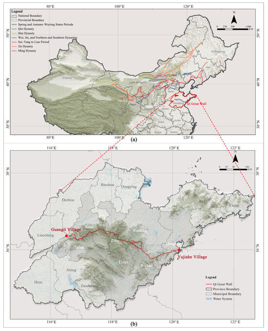
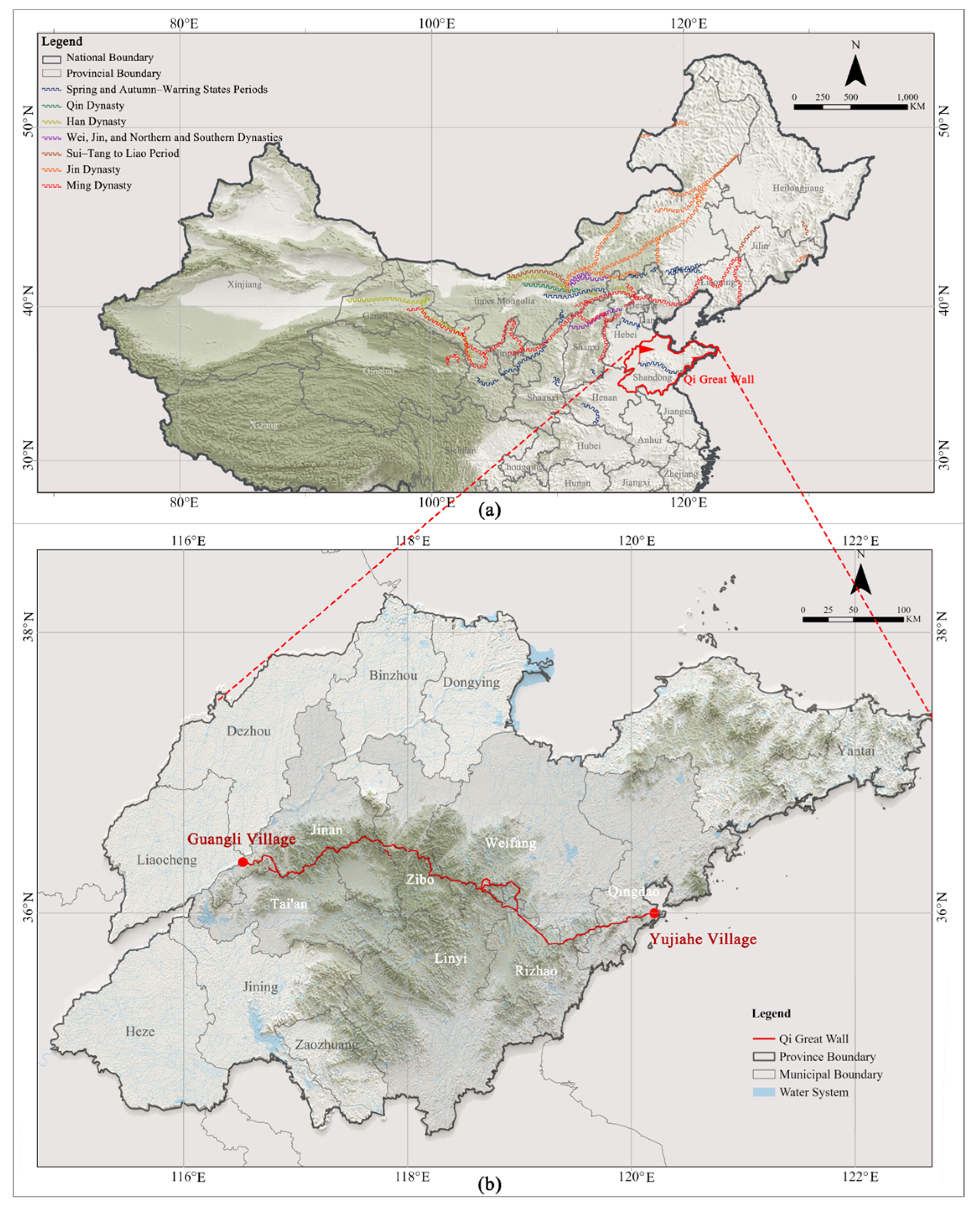
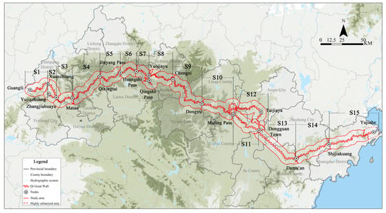
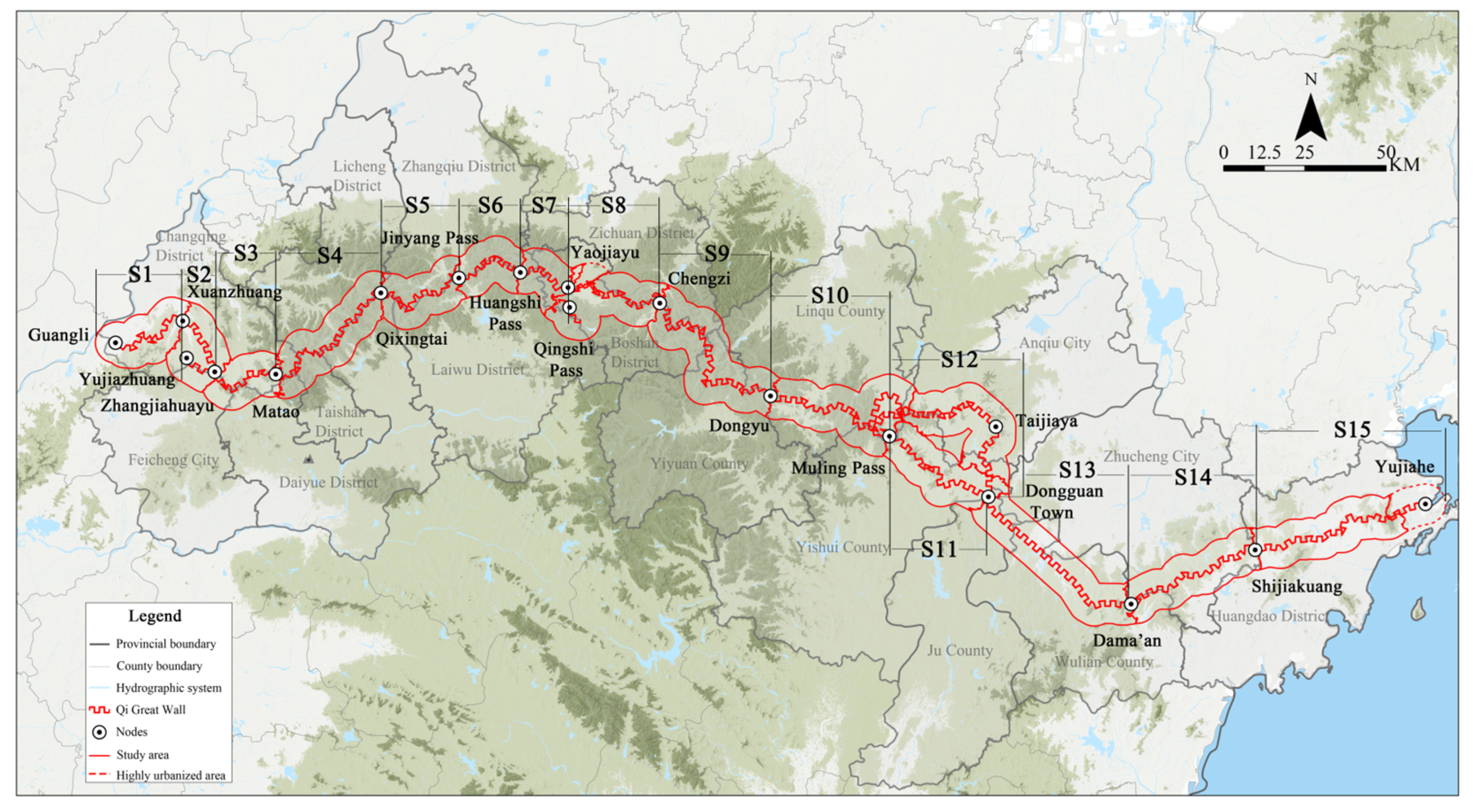
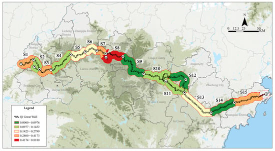
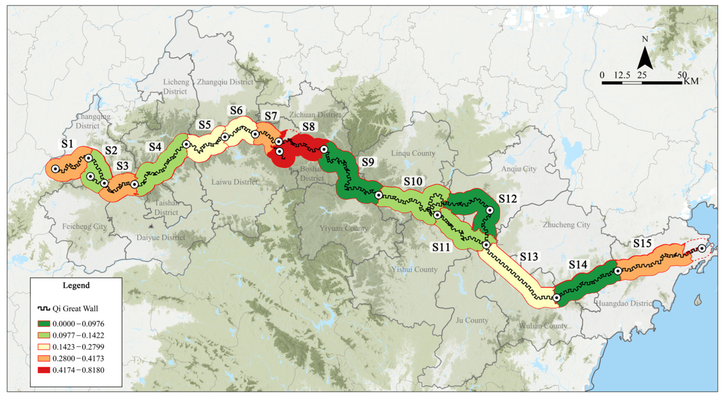
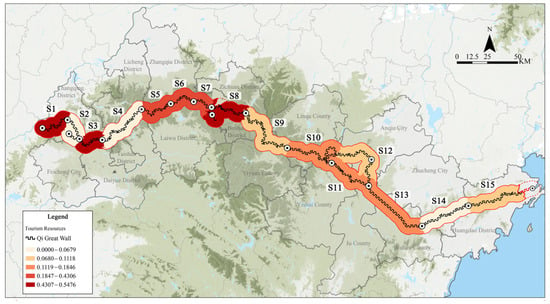
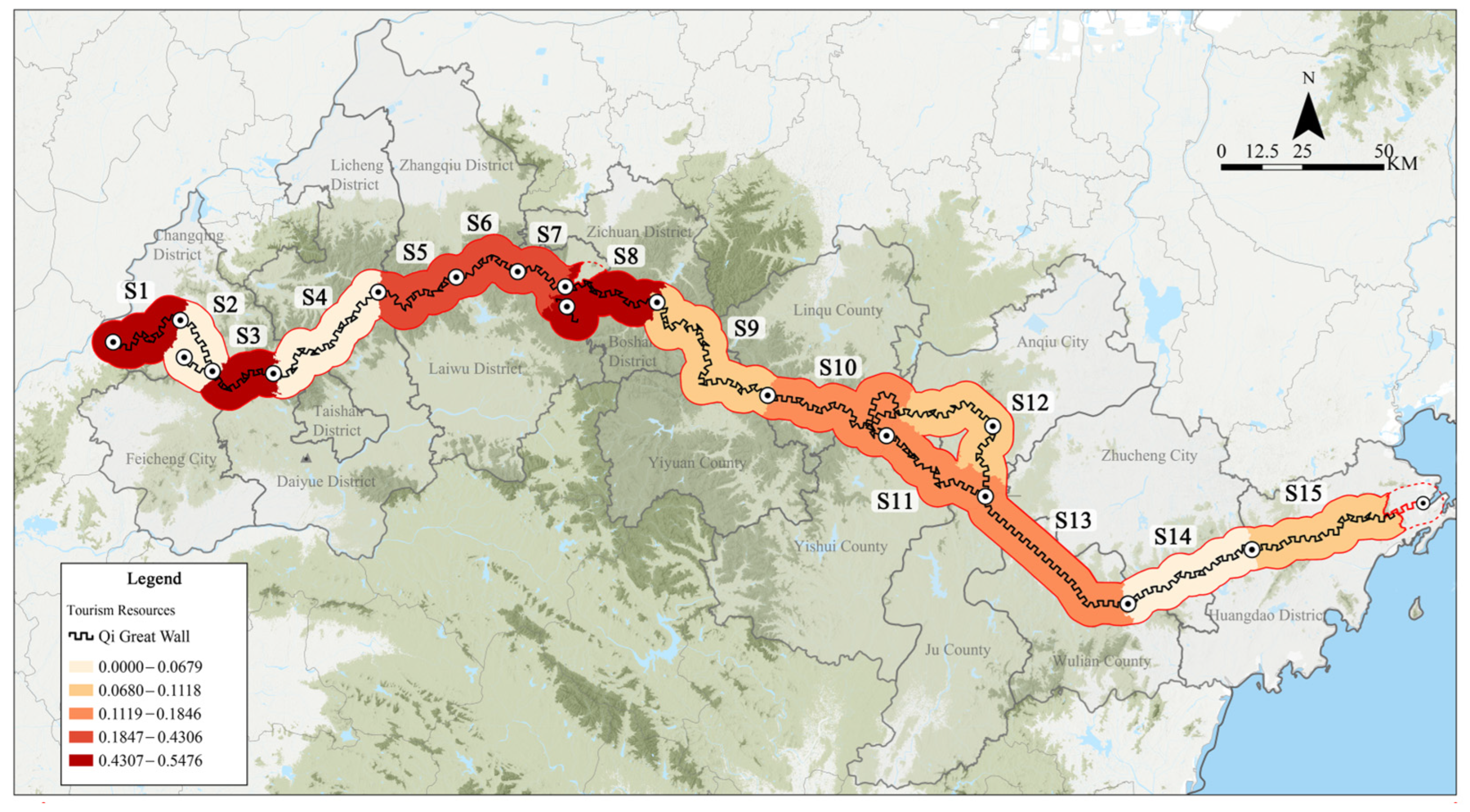
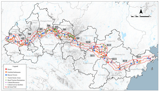
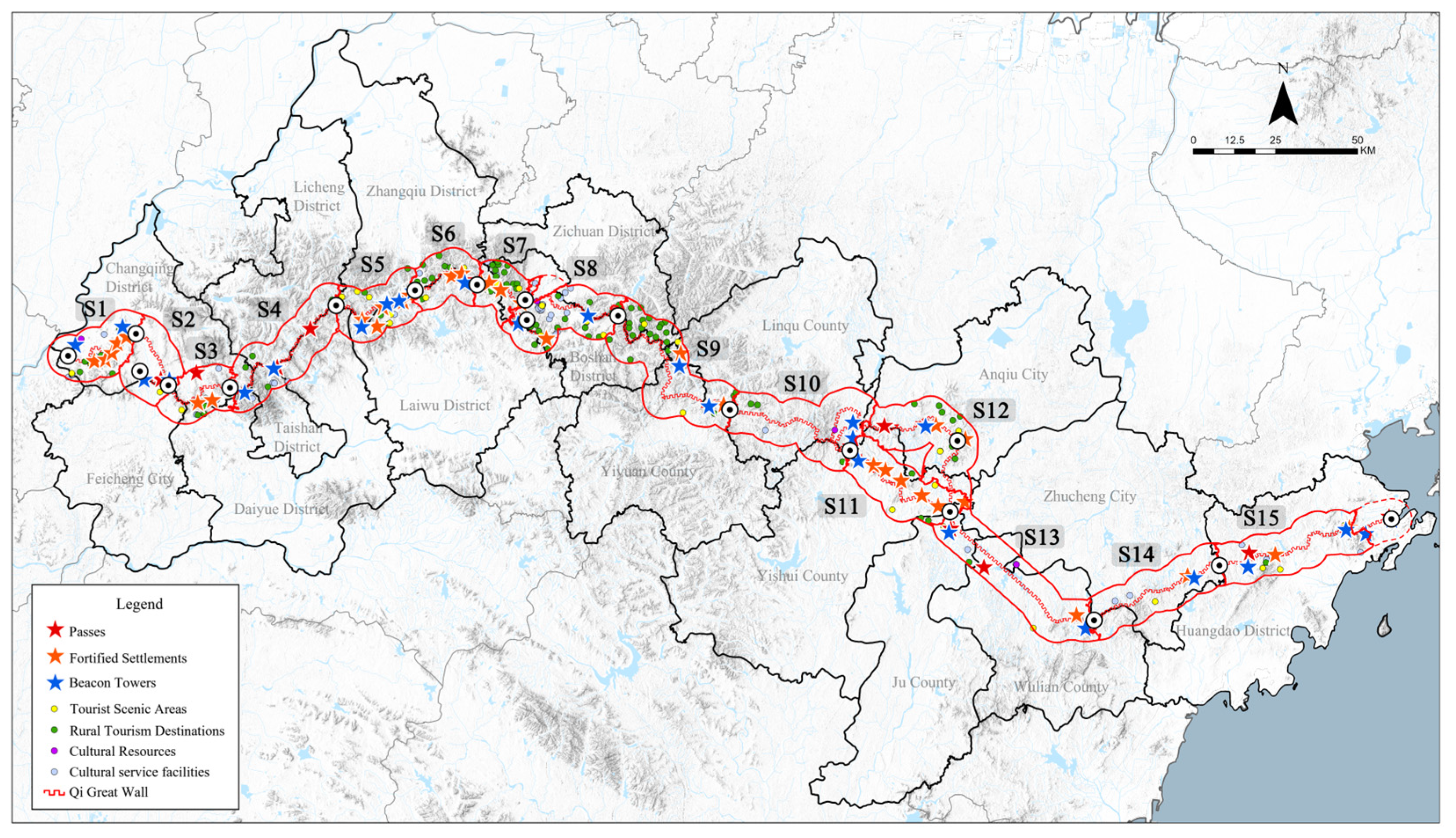
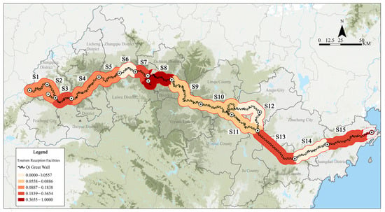
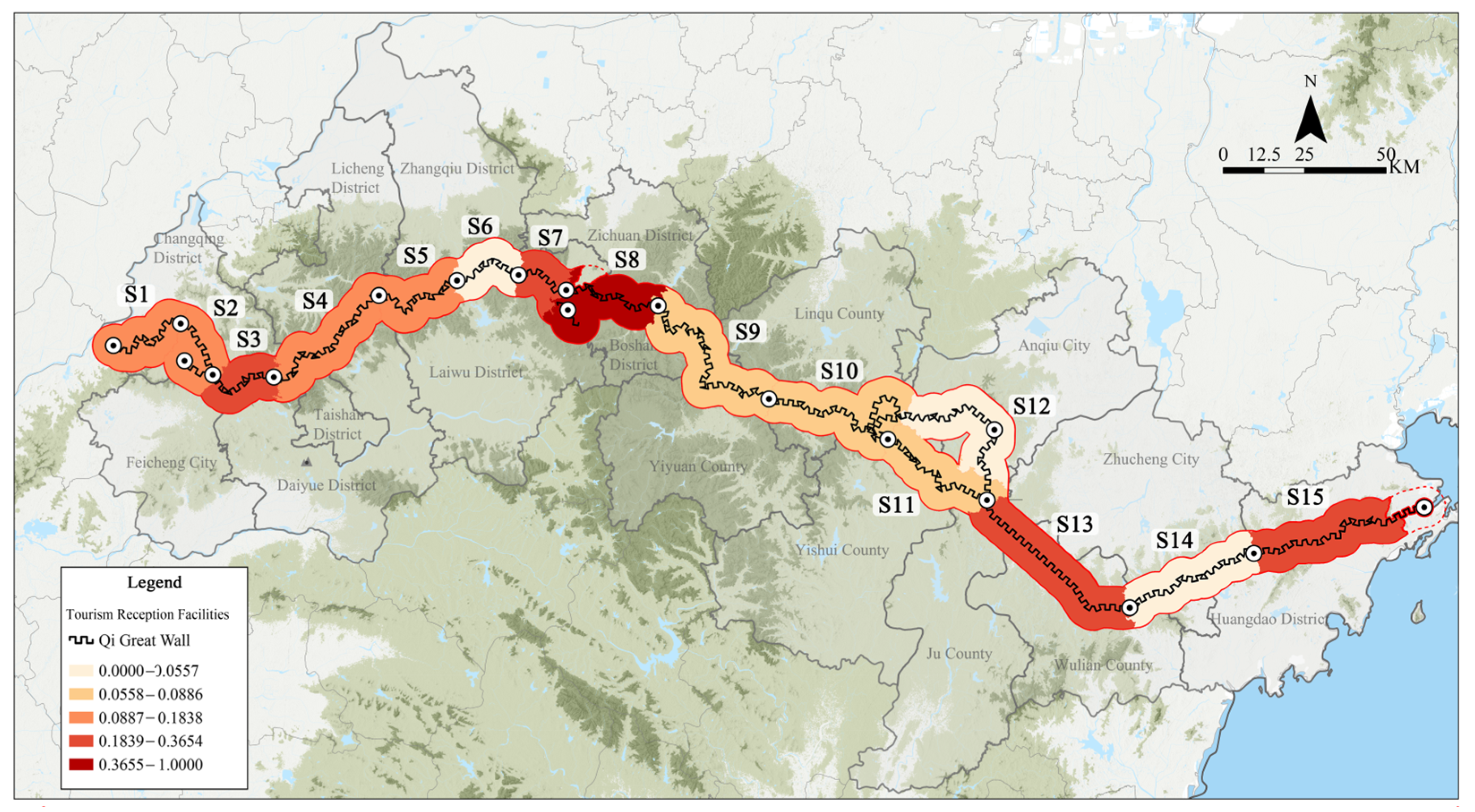
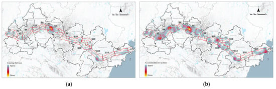
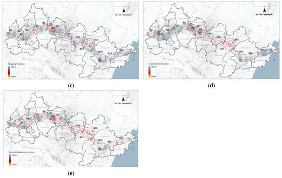
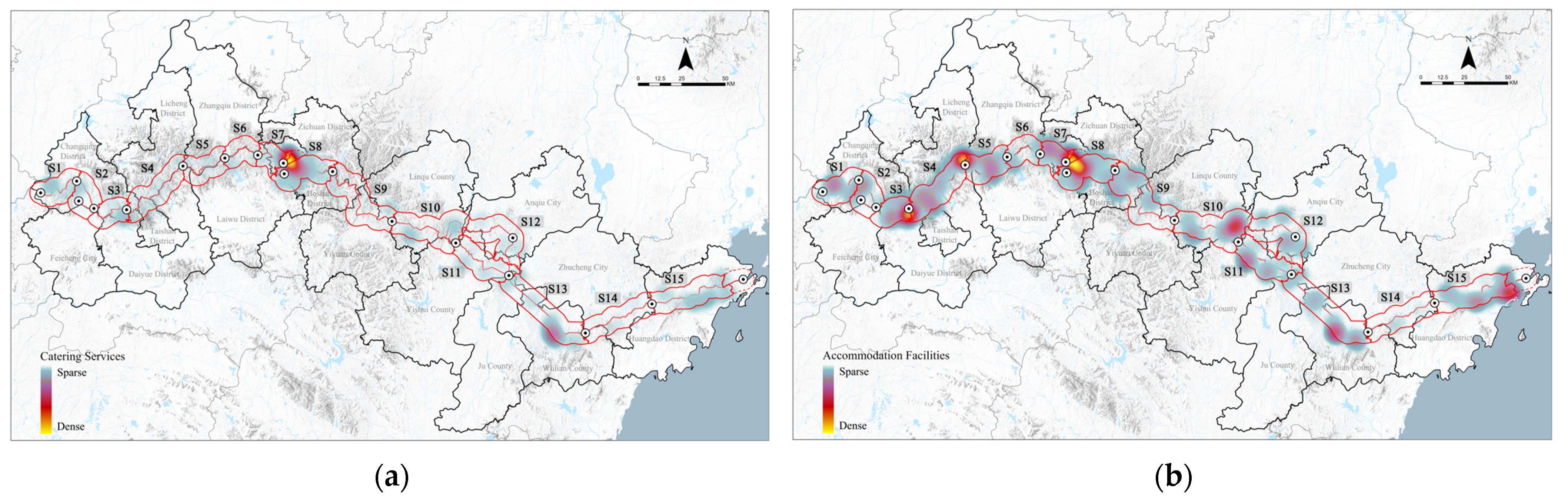
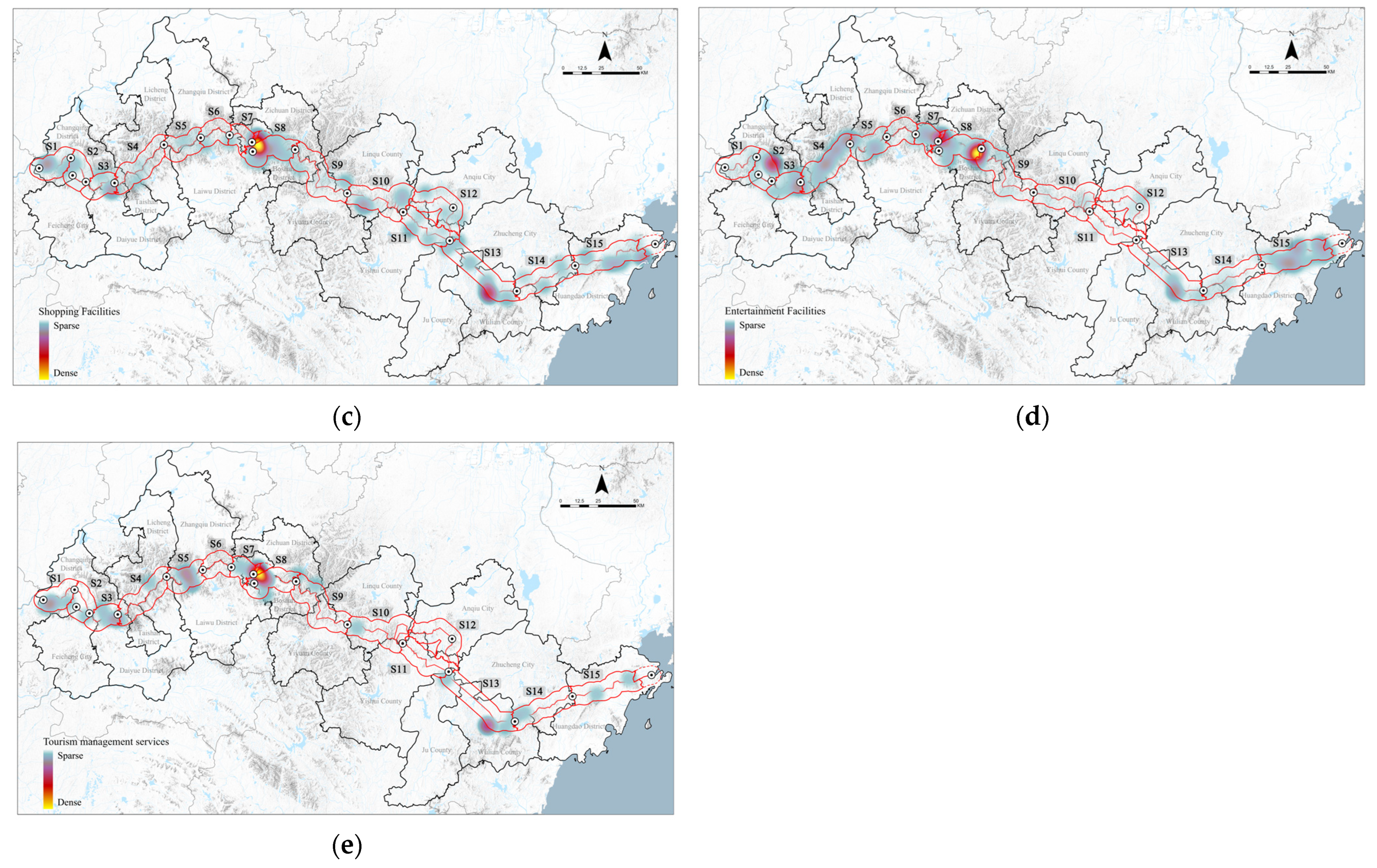
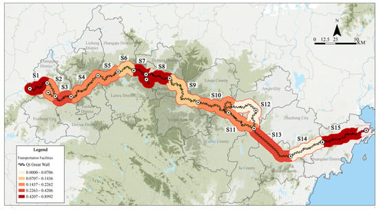
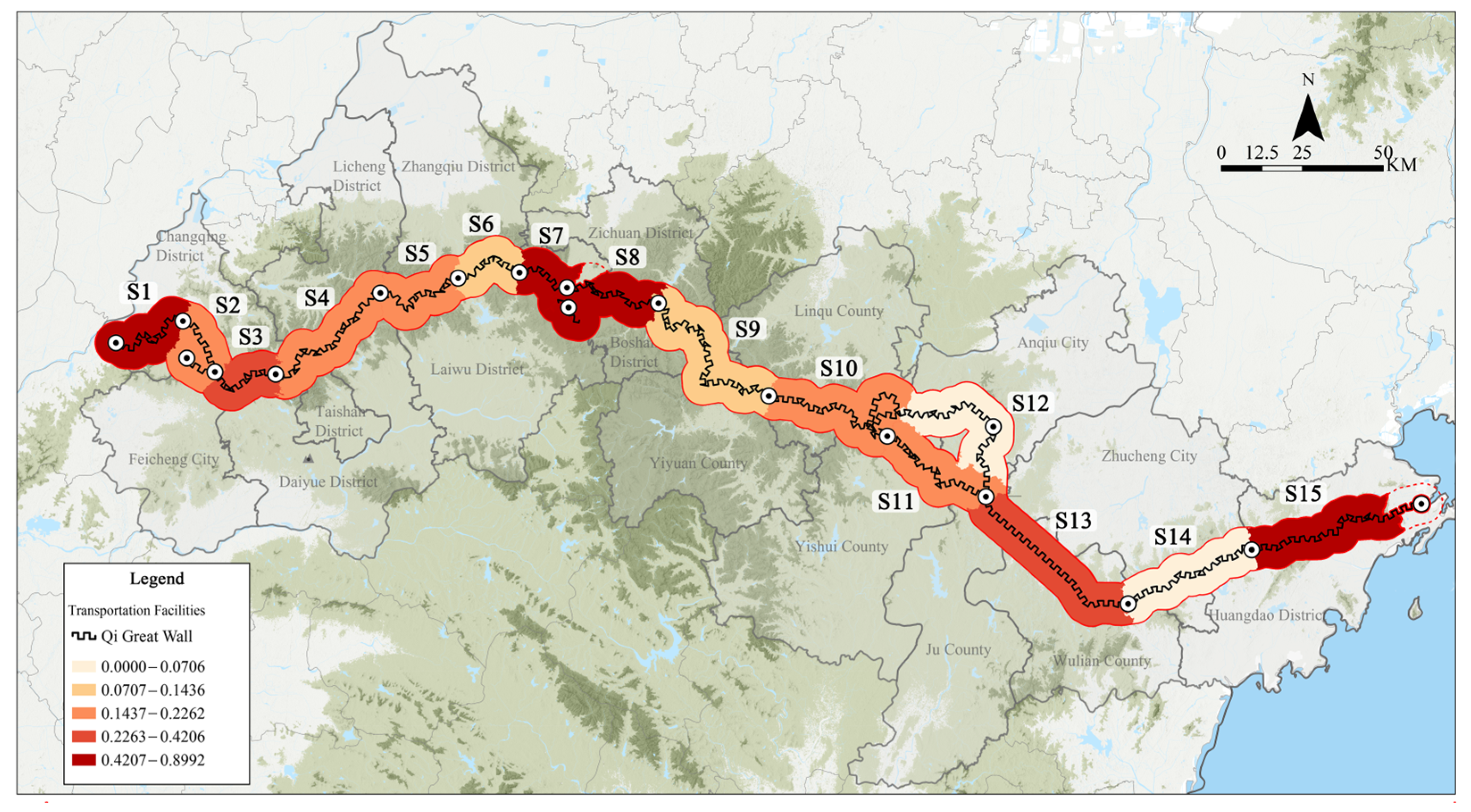
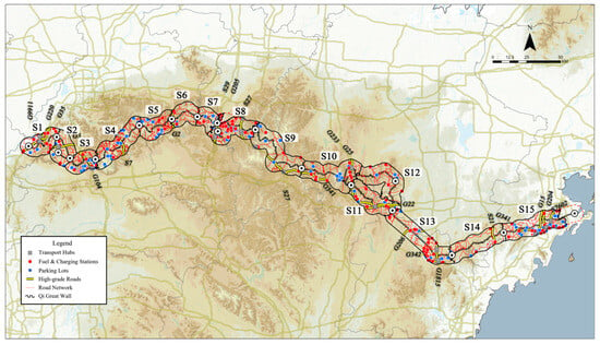
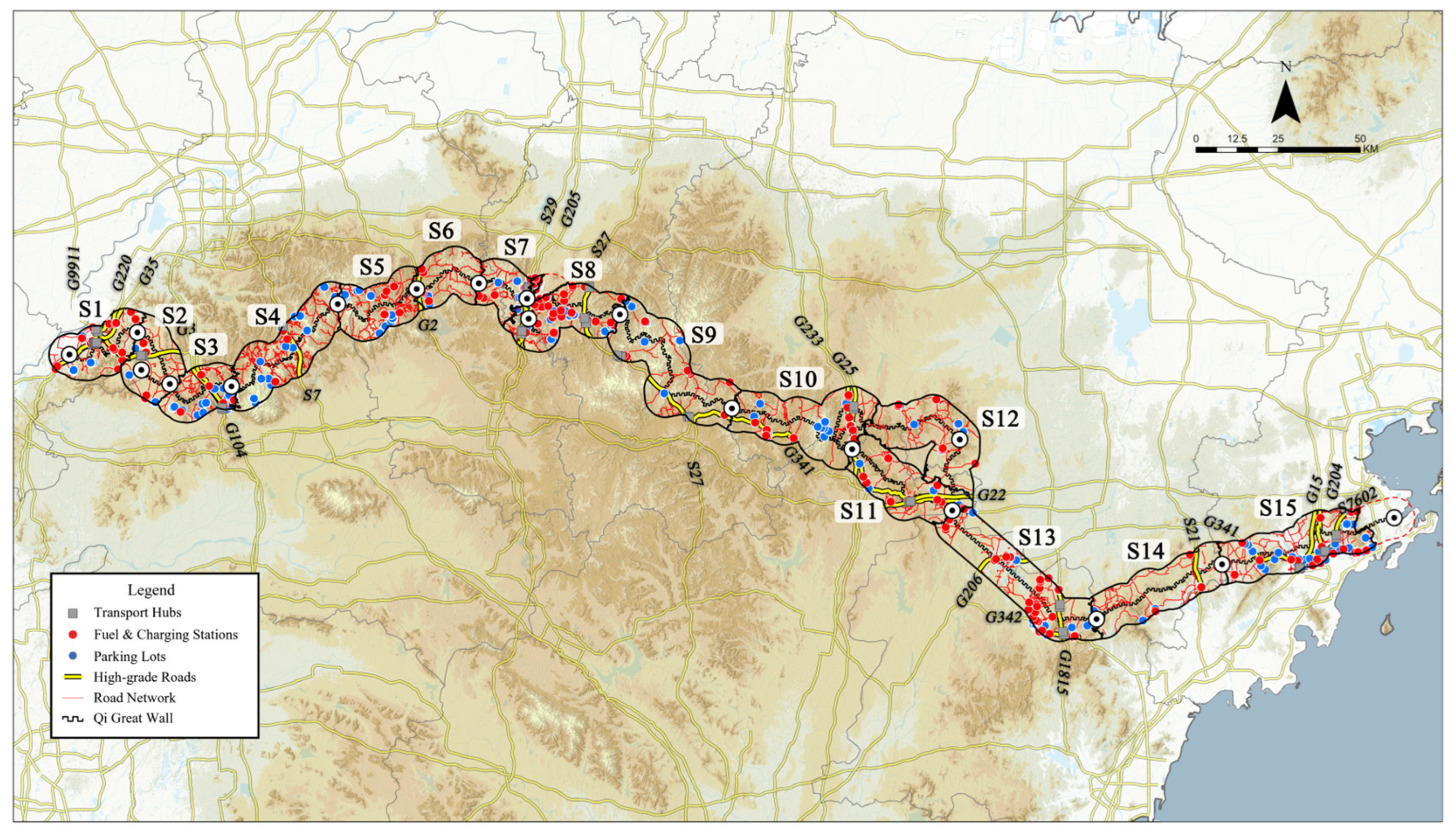
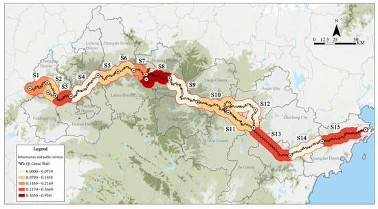
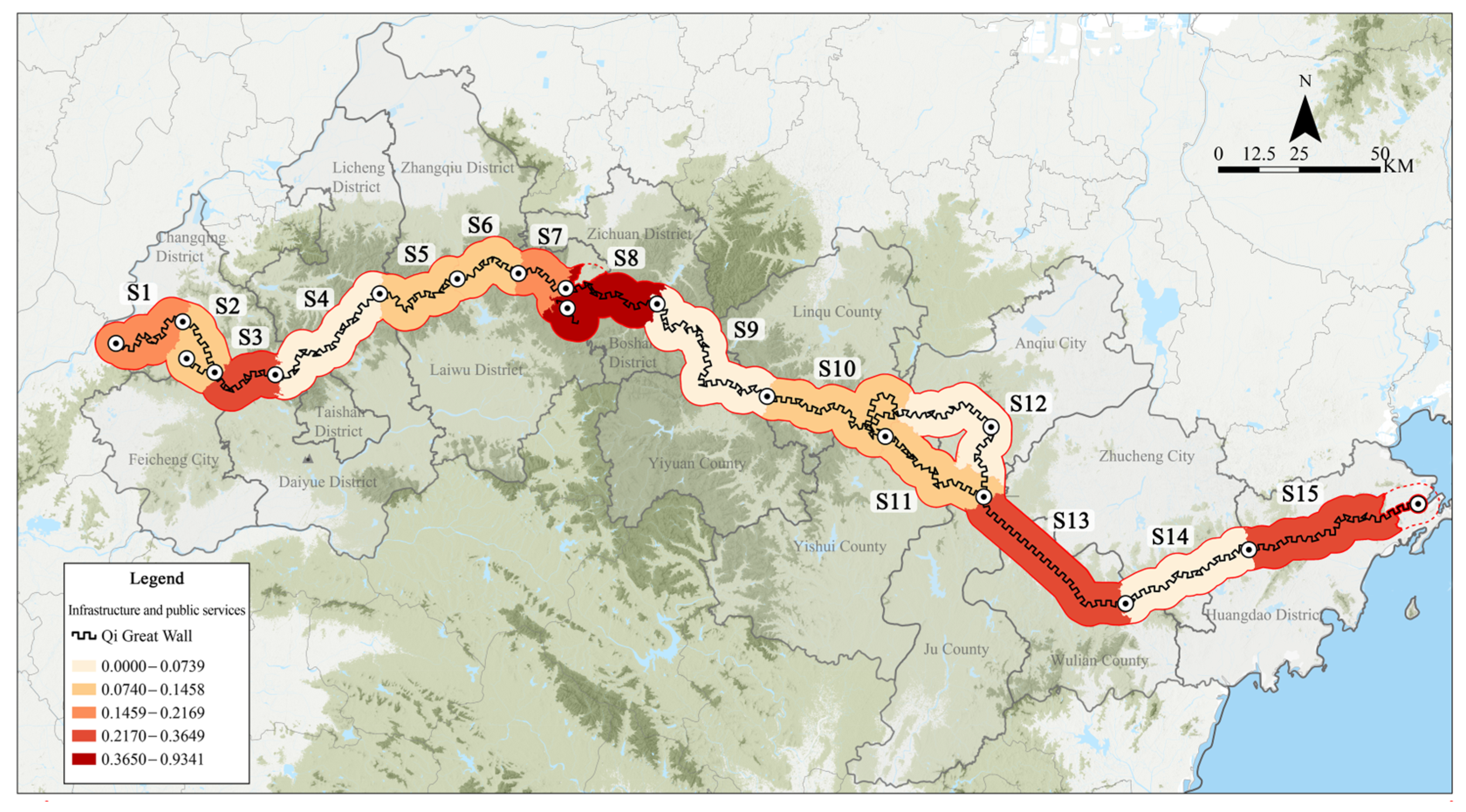
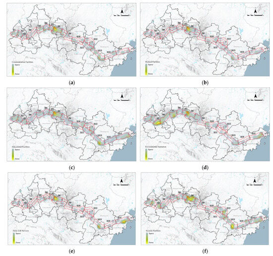
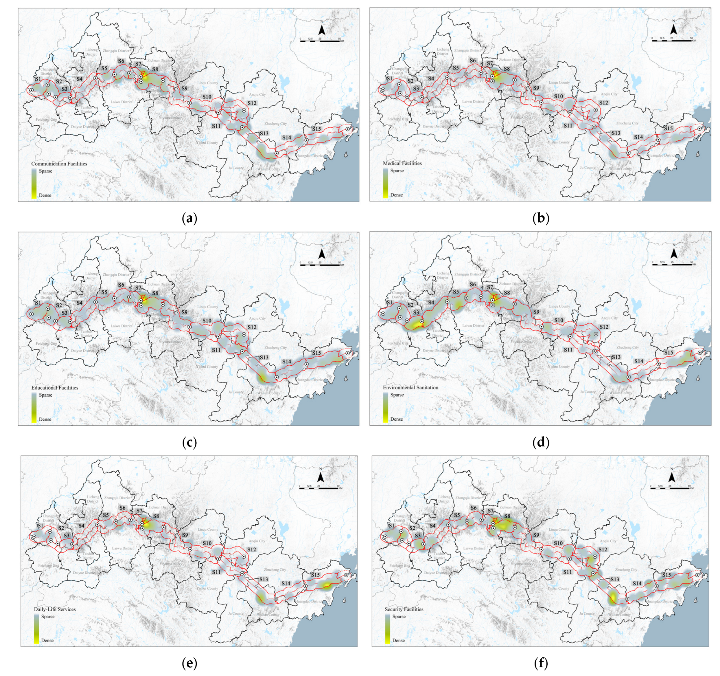
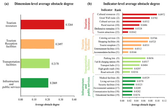
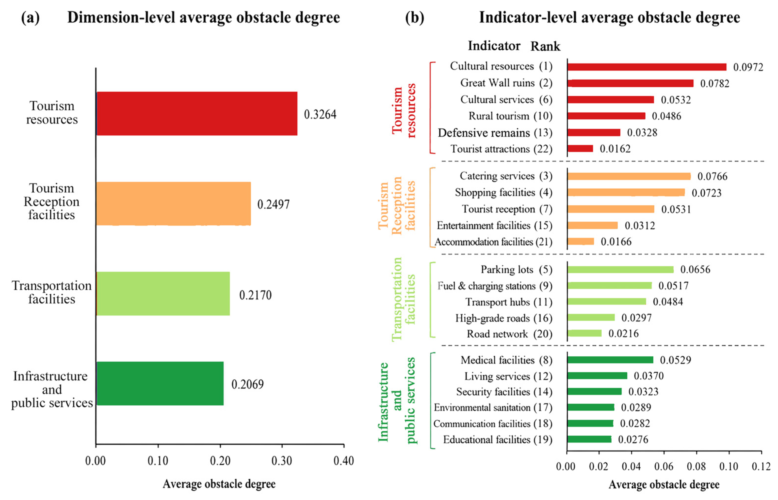


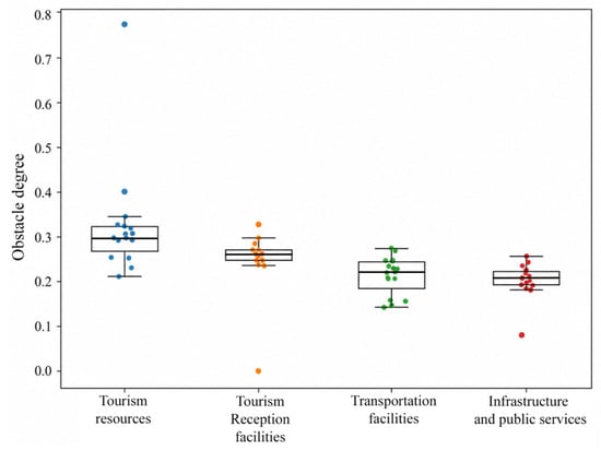
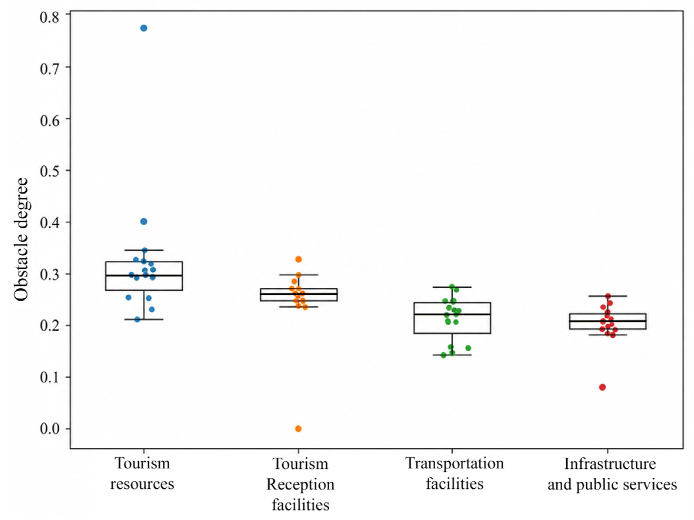
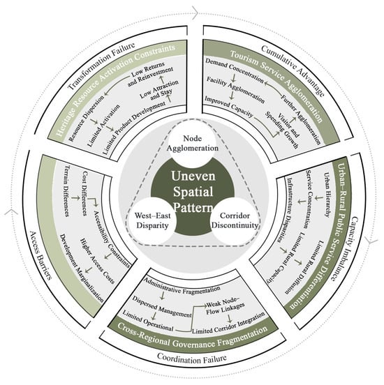
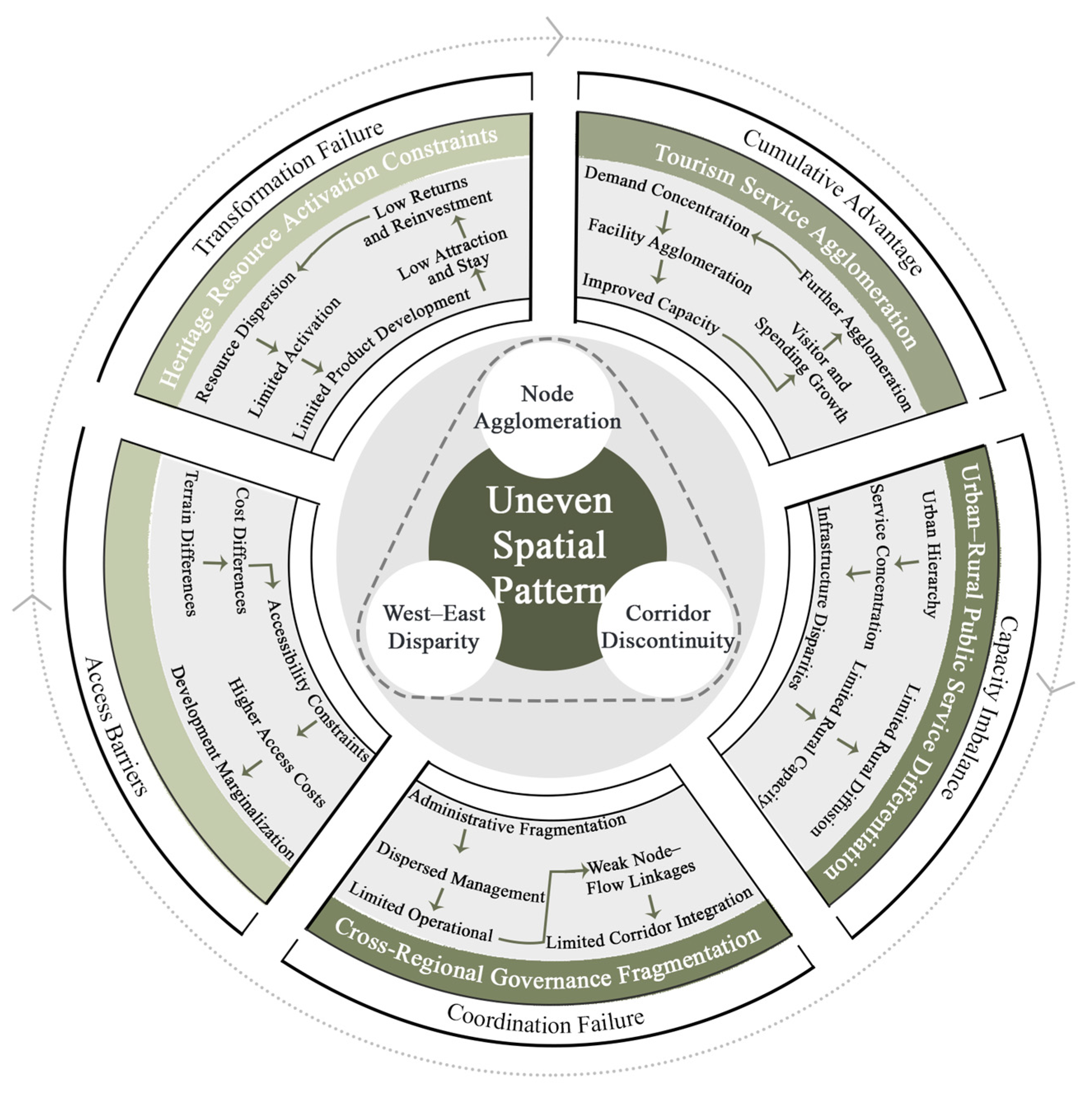

Disclaimer/Publisher’s Note: The statements, opinions and data contained in all publications are solely those of the individual author(s) and contributor(s) and not of MDPI and/or the editor(s). MDPI and/or the editor(s) disclaim responsibility for any injury to people or property resulting from any ideas, methods, instructions or products referred to in the content. |
© 2026 by the authors. Licensee MDPI, Basel, Switzerland. This article is an open access article distributed under the terms and conditions of the Creative Commons Attribution (CC BY) license.