


Abstract
The decision-making process for the adaptive reuse of cultural heritage requires the evaluation of multiple criteria because of its multifaceted structure. The criteria determined through a literature review were weighted by experts and ranked according to their degree of importance via the DEMATEL method, which is a multicriteria decision-making technique. This study, conducted by integrating the importance levels of the criteria determined by the DEMATEL method with Geographic Information Systems (GIS) techniques, was applied to Yediocak Primary School, one of the significant buildings in Osmaniye, affected by the 2023 Kahramanmaraş Pazarcık Earthquake and heavily damaged during the event. The DEMATEL analysis demonstrated that economic value, regional potential, and compatibility with the new function are the primary cause-group criteria, whereas architectural, cultural, and social values are predominantly situated within the effect group. The spatial assessment yielded a low suitability score for the current primary school function (0.3954). The hybrid DEMATEL + GIS index (0.2598) confirmed that a building’s reuse as a high-occupancy school is constrained by seismic risk, its position on a heavily trafficked corridor, and relatively limited access to healthcare and emergency assembly areas. This study aimed to establish a new framework for the adaptive reuse of historic buildings.
1. Introduction
Cultural heritage buildings define the identity of nations, and the preservation of these buildings is an important issue. One of the most effective ways to preserve these buildings is to ensure continuity of use with appropriate functions [1]. In recent years, several studies have framed adaptive reuse explicitly as a multi-criteria decision problem, using MCDM approaches to rank reuse strategies and support sustainable urban development and circular economy-oriented interventions for cultural heritage buildings [2,3,4].
Owing to factors such as the changing sociocultural environment, technology, and habits, heritage buildings become unable to respond to the needs of the period. At this point, the building can be sustained by giving it a different function [5,6,7,8]. In this process, one of the main principles is to intervene in the building at a minimum level and to preserve it with a function as close as possible to its original function. However, in practice, in some cases, historic buildings are used with functions that are not suitable for the needs of the period and the region, only to sustain their physical existence [9,10,11]. This situation causes buildings to become dysfunctional and turn into idle spaces, which constitutes a significant problem in today’s conservation practices. International documents and declarations emphasize that there are many different criteria in the selection of a new function and that these approaches should be considered together [12]. The importance of this issue was emphasized in the Nara Document [13] on Authenticity published in 1994, the Faro Convention adopted in 2005 and the Burra Charter dated 2013 [14,15]. When the criteria considered within the scope of the literature data on this subject are examined; Baker et al. [16] highlighted criteria such as environmental factors, structural systems, technical features, and compatibility with the new function. Vardopoulos [17] and Meng & Xiao [18] considered cultural, economic, environmental, and social values as evaluation criteria. Environmental factors require considering elements such as the context of the region, location, climatic characteristics, and natural landscape in the process of adapting the building to the new function. This approach contributes both to the preservation of the original values of the building and to the development of a sustainable form of use compatible with its surroundings [19,20,21]. The structural system plays a critical role in historical buildings that are included in the group of long-life structures, in terms of checking the reliability of load-bearing elements and safely implementing the spatial arrangements required by the new function [21,22].
In addition to these criteria, Alhojaly and Alzahrani [23] included elements such as architectural qualities and compatibility with the new function in their study. In addition, Mohamed and Marzouk [12] prioritized criteria such as architectural, environmental, social, sustainability, structural systems, esthetic and authenticity in the evaluation of three bank buildings with historical value. When architectural studies are examined, it can be observed that, among these criteria, aesthetic value and architectural value are considered as distinct and separate evaluation criteria. Among these criteria, the architectural criterion addresses the assessment of the compatibility between a historic building’s spatial configuration, plan typology, and circulation patterns and its original architectural character within the adaptive reuse process [24,25]. Esthetic value is evaluated through parameters such as visual quality, perceptual coherence, and symbolic meanings, which reflect the experiential and representational dimensions of the built environment [26,27]. The level of alignment between the proposed new function and the existing spatial organization directly influences the scope and intensity of architectural interventions. Accordingly, the architectural criterion plays a crucial role in ensuring the conservation of the building’s authentic values while facilitating the sustainable and functional integration of the new use. Özeren and Korumaz [28], on the other hand, used cultural, environmental and economic values as criteria in addition to these. Economic values encompass financial resources, initial investment and subsequent maintenance requirements, profitability, and market demand. Environmental analysis involves the examination of the environmental context and encompasses contextual characteristics as well as data such as land use and zoning plans [28,29]. Unlike other studies, Li et al. [30] considered technical data as an evaluation criterion (Table 1). Technical areas are critical areas that ensure the regular and safe operation of the mechanical, electrical, and installation infrastructure of the building. These areas make it possible to integrate modern functions without damaging the original fabric of buildings and have great importance in the reuse process [19,20]. The compatibility with the new function/function criterion emphasizes the importance of assessing the alignment between a building’s performance capacity and the requirements of the proposed new function [22].
Table 1.
Literature summary—criteria used in the evaluation of the suitability of historic buildings: (C1: Architectural, C2: Cultural, C3: Economic, C4: Environmental, C5: Social, C6: Sustainability, C7: Structural System, C8: Authenticity, C9: Regional Potential/Need, C10: Esthetic, C11: Technical, C12: Compatibility with New Function/Function).
Repurposing existing structures with cultural or social significance and evaluating them for diverse functions highlights the necessity of incorporating these criteria [50,51,52,53]. In this context, spatial decision support systems (SDSS) and geospatial analysis tools provide substantial capabilities for evaluating the reuse potential of buildings, allowing decision-makers to integrate a wide range of environmental, structural, accessibility, and socioeconomic factors in a cohesive manner, as demonstrated by recent SDSS frameworks for heritage reuse and sustainable building renovation [54,55,56].
Currently, numerous studies in both the national and international literature have examined the selection of appropriate functions for historic buildings. Research by Sipahi et al. [57], Cucco et al. [58], Mohamed and Marzouk [12], Li et al. [30], and Arfa et al. [59] has demonstrated the use of methods such as surveys, Analytic Hierarchy Process (AHP), and fuzzy logic in this context. On the other hand, despite the integration of Decision Making and Trial Evaluation Laboratory (DEMATEL), a multicriteria decision-making method, with Geographical Information System (GIS) which has been applied in areas such as urban transformation, sustainable planning of ecotourism resources, and flood risk assessment, studies specifically addressing this approach for the adaptive reuse of historic buildings are still lacking [60]. The proposed method aims to support informed and accurate decision-making regarding the adaptive reuse of buildings by integrating topography data, proximity to infrastructure, and service accessibility layers with criteria emphasized by stakeholders. However, within the scope of the adaptive reuse of historic buildings, it has been observed that the literature lacks a comprehensive study that addresses multi-criteria decision-making mechanisms through an integrated DEMATEL and GIS approach, going beyond traditional methods.
In this context, the present study aims to address this gap by evaluating the reusability of Yediocak Primary School, an important historical structure in Osmaniye, Turkey, through a hybrid GIS–DEMATEL decision model. Accordingly, the main objective of this study is to assess multi-criteria decision-making mechanisms in the context of the adaptive reuse of historic buildings, moving beyond traditional approaches through. Within the scope of the study, the most frequently used parameters for the adaptive reuse of historical buildings were identified through a comprehensive literature review and are presented in Table 1. The importance levels of these parameters were weighted by a group of experts experienced in restoration and calculated via the DEMATEL method. These parameters, combined with GIS integration, were subsequently used to assess the functional suitability of Yediocak Primary School.
The remainder of this manuscript is structured as follows. Section 2 presents the study area and the characteristics of the Yediocak Primary School as a registered cultural heritage asset within the post disaster urban context of Osmaniye and details the research methodology, including the selection of evaluation criteria, the DEMATEL-based weighting of expert judgments, the GIS-based spatial analyses, and the hybrid DEMATEL + GIS integration. Section 3 reports the results of the DEMATEL analysis, spatial suitability assessments, and hybrid evaluation for the case study building. Section 4 discusses these findings in relation to adaptive reuse, risk, and urban resilience. Section 5 provides conclusions and outlines recommendations and directions for future research.
2. Materials and Methods
2.1. Material
This research was conducted in Osmaniye Province, located in the eastern part of the Çukurova Region in Turkey, which is rich in historical and archeological remains but where sufficient measures have not been taken to preserve its architectural heritage [61,62]. Today, the city has a limited number of registered buildings, which were damaged during the 2023 Kahramanmaraş Pazarcık Earthquake. Within the scope of the study, the adaptive reuse process of Yediocak Primary School, a significant building of the city, located between Akyar Street and Mareşal Fevzi Çakmak Street in the city center, was examined (Figure 1).
Figure 1.
Location of Yediocak Primary School.
The building, constructed in 1910, has a rectangular plan scheme and opens onto an L-shaped courtyard. In its original form, the building was designed as a single-story structure made of cut stone material, and a reinforced concrete floor was added during a renovation project between 1973 and 1974. The main entrance of Yediocak Primary School is located on Akyar Street, whereas the garden entrance is on Mareşal Fevzi Çakmak Street. The facades of the registered building are characterized by simple and low-arched window surroundings. New volumes serving as classrooms, kindergartens, and meeting halls were added to the courtyard of the building, which is used as a school, over time because of insufficient capacity. The registration decision of the building was made by the Adana Regional Board for the Protection of Cultural Heritage with decision number 4131 dated 27 February 2001.
The building, which was severely damaged in the 2023 Kahramanmaraş Pazarcık earthquake, could begin restoration work only March 2025, more than two years after the earthquake (Figure 2).
Figure 2.
Images showing the conditions of the structure before and after the Pazarcık earthquakes in Kahramanmaraş.
One of the reasons for this delay was the indecision of local authorities regarding the adaptive reuse process of Yediocak Primary School. The building’s location on the city’s main commercial axes brought some disadvantages in its use as a school. Accessibility and capacity issues were the main topics of discussion. However, during the functional adaptation process, authorities decided to reuse it as a primary school, considering that there was no other educational institution in the region and that the building should be preserved with its original function. As the damage assessment reports indicated that the first floor, which was added later, caused the main damage to the building, it was decided in the restoration project to preserve Yediocak Primary School as a single-story structure. The new classrooms required by the school function were accommodated within a newly constructed three-story volume added to the existing building.
The building is 26 m wide and 35 m long, with a total usable area of 910 m2. As part of the restoration project prepared in 2025, an additional mass is planned to be constructed, consisting of three floors with a total enclosed area of 4500 m2 and a footprint of 1500 m2.
2.2. Methods
In this study, a hybrid methodology that integrates expert-based DEMATEL analysis with GIS–based spatial analyses is adopted to comprehensively evaluate multi-criteria decision-making processes in the adaptive reuse of historic buildings. The proposed approach is applied to the registered historic structure Yediocak Primary School, located in the city center of Osmaniye, Turkey, with the aim of systematically assessing its reusability potential by considering both qualitative and spatial dimensions. The aim is to perform a thorough assessment that evaluates both the internal and architectural features of a building through expert opinions, while also integrating essential geographic and infrastructural factors utilizing geographical data. The approach is explained in detail in the flow diagram shown in Figure 3.
Figure 3.
Overall workflow of the proposed hybrid DEMATEL + GIS methodology. The framework consists of four main stages: (1) study area and case selection, (2) DEMATEL-based weighting of reuse criteria from expert judgments, (3) GIS-based spatial analysis and suitability mapping via environmental and accessibility layers, and (4) integration of conceptual and spatial criteria to derive the final hybrid suitability index and map for Yediocak Primary School.
The approach comprises four primary steps:
- The evaluation criteria were identified and selected through a comprehensive examination of the literature and expert consultation,
- DEMATEL analysis uses survey data from 21 subject-matter experts to find relationships and weights between the criteria.
- GIS-based spatial analysis involves the manipulation and normalization of raster layers representing variables such as slope, proximity to faults, road accessibility, healthcare service availability, and designated emergency assembly locations.
- Hybrid integration combines GIS-based indicators with relevant DEMATEL-weighted criteria to create a single appropriateness score for the target structure.
This approach allows for a multidimensional and location-aware assessment that supports urban planning decisions and adaptive reuse strategies for heritage structures, particularly under resilience, accessibility, and hazard mitigation concerns.
2.2.1. Identification and Selection of Evaluation Criteria
This section of the study comprehensively addresses the evaluation criteria for historical structures, which were identified through a literature review and represent the 12 most frequently cited criteria in the literature (Table 1). The weights of these criteria were calculated within a framework that enables the combined use of GIS and DEMATEL methods. The 12 criteria include architectural, cultural, economic, environmental, social, sustainability, structural system, authenticity, regional potential/need, esthetics, technical, and adaptation/function to a new use.
2.2.2. DEMATEL Analysis
In this step, the importance levels of the criteria were determined by a group of 21 experts, consisting of 19 architects and 2 restorers, who are familiar with the city, possess knowledge about the building, have at least ten years of professional experience, and have been involved in conservation projects. Among the experts, there are three academics working in the Architecture, Building Science, and Restoration Departments at Osmaniye Korkut Ata University; four professionals employed in public institutions and organizations authorized to make decisions regarding conservation and restoration regulations; and 14 individuals who own private offices. In the selection of local experts for the study, the fact that these individuals are potential users of the building played an influential role.
To understand the structural and contextual dynamics affecting the reusability of a registered historical building, the DEMATEL method was utilized. DEMATEL allows for the identification of complex interdependencies among criteria and the determination of cause–effect relationships, making it highly effective for adaptive reuse and urban heritage decision-making problems.
A total of 12 evaluation criteria were identified based on a thorough literature review and expert consultation. These criteria reflect architectural integrity, spatial risk, social value, and functional viability. Each criterion is labeled C1 through C12 and is defined in Table 1.
A structured survey was distributed to 21 domain experts (see Supplementary Materials), including professionals in architecture, urban conservation, planning, and structural engineering. Each expert was asked to assess the influence level of each criterion on the others via a 0–4 scale:
- 0: No influence;
- 1: Low influence;
- 2: Medium influence;
- 3: High influence;
- 4: Very high influence.
The responses were compiled and analyzed via the DEMATEL method to derive a standardized influence structure. The DEMATEL process went through these steps in order: Expert judgments were put into a square matrix , where each element xij shows how criterion i affects criterion j. The maximum row sum method was used to normalize the matrix, ensuring that all values were between 0 and 1 [63]. The total influence matrix was calculated via the following formula :
where is the identity matrix of the same size as .
For each criterion, two values were calculated: Di, the sum of the row values (influence given), and Ri, the sum of the column values (influence received). The prominence (Di + Ri) indicates the overall importance of criterion i within the system, whereas the relation (Di − Ri) is used to classify the criterion as either a cause (if Di − Ri > 0) or an effect (if Di − Ri < 0).
2.2.3. GIS-Based Spatial Analysis
The building in question is the Yediocak Primary School, which is located in the historic center of Osmaniye, Turkey. We used GIS analysis to map out how ready we were for disasters, how easy it was to reach places, and how safe the environment was. When deciding whether to repurpose heritage buildings in cities, all of these factors are very important. We chose five spatial criteria on the basis of a review of the literature, expert advice, and their importance to urban resilience: slope, distance from fault lines, distance from healthcare facilities, distance from assembly areas, and distance from the road network. We computed Euclidean distance rasters to represent proximity to roads, healthcare facilities, assembly areas and faults. Euclidean distance is widely used in GIS-based MCDA studies as a proxy for spatial accessibility and hazard exposure, particularly in urban contexts where the road network is relatively dense and regular. We focus on relative proximity rather than exact travel paths; however, future work could incorporate network-based or Manhattan distance metrics to represent route-based accessibility in more detail.
ArcGIS Pro 3.4 was used to create a raster layer for each spatial criterion. In this study, the Euclidean distance was used to generate continuous proximity rasters for roads, healthcare facilities, assembly areas and fault lines, as a standard first-order approximation of spatial accessibility and hazard exposure in raster-based suitability analysis. Additionally, SRTM Digital Elevation Model (DEM) was used in this research to find the slope. To ensure that they could be compared, all of the rasters were resampled to the same resolution and normalized via min–max scaling. The normalization was performed via the following formula [64]:
where X is the raw raster value, and are the minimum and maximum values of the raster, respectively, and is the normalized value in the [0, 1] interval. Using the slope tool, we obtained slope values from the DEM. Flatter terrains were given higher normalized values because steeper slopes can make structures less stable and make it harder to reach them in an emergency. Three major hospitals within the study area were selected as reference healthcare facilities, and the Euclidean distances from each building to these hospitals were calculated to assess healthcare accessibility. An inverse normalization was used so that shorter distances indicate better suitability. We used vector data showing major and secondary roads to determine how close something was to the road network. Assembly areas are very important after a disaster, so they were mapped and examined in terms of distance, with locations closer to designated zones being preferred. Finally, we used official seismic hazard data from MTA [65] to determine how far each point was from fault lines. The farther away the point was, the better it was because there was less risk of an earthquake. Table 2 shows how the Yediocak Primary School’s normalized scores were figured out from each raster dataset. These numbers show how well the building fits in with its surroundings on the basis of only on GIS-based physical and environmental factors.
Table 2.
Normalized scores for the Yediocak Primary School.
The AHP was used to objectively weigh how important each spatial criterion was. A structured pairwise comparison survey was used to obtain expert opinions, and the pairwise matrix was normalized to find the priority vector. The Consistency Ratio (CR) was used to measure how consistent the expert input was. It was calculated as follows [64]:
where is the principal eigenvalue, n is the number of criteria and RI is a random index for the corresponding n. For n = 5, RI = 1.12 and the calculated CR was 0.04, including a consistent comparison matrix (CR < 0.10).
2.2.4. Integration of GIS and DEMATEL for Hybrid Suitability Scoring
To enhance the spatial decision-making process, GIS-based indicators were amalgamated with expert-derived priorities from the DEMATEL analysis. GIS analysis provides geographic and topographic suitability values, whereas the DEMATEL method elucidates interdependence and causal relationships within a more extensive array of reusability criteria. This hybrid approach aims to represent both spatial practicality and expert knowledge-driven strategic relevance.
Among the 12 DEMATEL criteria, five had clear spatial expressions and were therefore operationalized as GIS layers: slope, road distance, emergency assembly area proximity, fault distance, and healthcare facility proximity. For each of these spatial criteria, the DEMATEL weight of the most closely related conceptual criterion was used in the hybrid integration each of which matched its corresponding GIS raster layer. Concretely, environmental/seismic safety and Technical–Structural considerations are reflected in the slope and fault-distance layers, while Social and Functional safety in emergency situations are partially represented through road accessibility, assembly area proximity and healthcare facility proximity. The remaining DEMATEL criteria do not have direct spatial proxies in this study and are therefore interpreted only within the conceptual DEMATEL analysis. Normalized GIS scores were multiplied by the DEMATEL weights (based on the D + R values normalized over 1) to derive the hybrid suitability score. The formula for hybrid scoring is as follows:
where is the hybrid score for criterion i, is the normalized GIS score for criterion i and is the normalized DEMATEL weight for criterion i.
These hybrid scores were summed up to produce an integrated reusability score for the building location. Raster maps were generated to visualize both the GIS-only and Hybrid GIS + DEMATEL results via raster calculations. This dual approach offers stakeholders a multidimensional tool to support decisions on heritage building reuse, combining on-the-ground geographic feasibility with systemic strategic importance assessments.
Operationally, the integration follows a standard weighted linear combination scheme widely used in GIS-based multicriteria evaluations. For each spatial criterion i that has a DEMATEL counterpart, the corresponding raster layer is first normalized to the [0, 1] range via min–max scaling. The global influence weight , derived from the normalized DEMATEL D + R scores, is then assigned uniformly to that criterion and applied as a scalar to all the cells in the layer, yielding a weighted map . The hybrid suitability surface is obtained by summing these weighted layers across the five spatial criteria:
The hybrid score reported for the Yediocak primary school corresponds to the value of at the cell containing the building footprint, which makes the DEMATEL influence structure explicitly visible in geographic space. Conceptually, this procedure is analogous to AHP–GIS and other MCDA–GIS frameworks where expert-derived weights are applied to normalized raster criteria to produce composite suitability maps; in our case, the novelty lies in obtaining the weights from a DEMATEL cause–effect network rather than from pairwise comparisons alone. Thus, the hybrid DEMATEL + GIS index should be interpreted as a spatial projection of those criteria with clear safety and accessibility components, complementing the full 12-criteria DEMATEL evaluation.
In this framework, AHP is employed exclusively in the GIS-only phase (Section 2.2.3) to obtain a set of internally consistent weights for the spatial criteria and to produce a conventional MCDA–GIS suitability map. In contrast, the hybrid DEMATEL + GIS index relies exclusively on the global influence weights derived from DEMATEL, which are projected onto the corresponding spatial layers. The decision has been made to refrain from combining AHP and DEMATEL weights in the final index. This approach is motivated by the recognition that the utilization of two distinct weighting schemes for the same criteria has the potential to obfuscate the underlying preference structure. Furthermore, it could lead to the inadvertent duplication of certain factors. Conversely, AHP serves as a benchmark for the spatial indicators, while DEMATEL provides a single, coherent weighting system that also captures the underlying cause-and-effect relationships among criteria.
3. Results
3.1. DEMATEL Analysis Results
In this section, we present the results of the DEMATEL analysis conducted based on expert evaluations of 21 professionals across multiple disciplines. The method helps identify the interrelations and relative importance (weights) of the 12 criteria used in assessing the reusability of registered buildings. The normalized importance values (D + R) were taken as the final weights for integration with GIS-based analysis. Table 3 shows the final influence degrees, cause–effect relationships, and normalized weights.
Table 3.
Final DEMATEL scores for all reusability evaluation criteria.
The DEMATEL cause–effect diagram (Figure 4) shows how each reusability criterion fits into the decision-making process in a full way. The D + R axis shows how important each criterion is to the whole system, and the D − R axis shows how the criterion affects the system. If it has positive values, it is included in the cause group. If it has negative values, it goes in the impact group. This analysis with two axes helps to separate strategic drivers from response outcomes.
Figure 4.
DEMATEL cause–effect diagram for the 12 evaluation criteria. The horizontal axis shows the importance degree (D + R), while the vertical axis represents the net causal influence (D − R). Blue markers denote cause-group criteria (D − R > 0), which exert influence on other criteria; red markers denote effect-group criteria (D − R < 0), which are more influenced by other criteria.
Things occur because of the economic, regional, potential, functional adaptation, environmental, technical, and esthetic criteria. Economic factors are the main cause, and they have the highest D − R value (+1.70). This shows that the economy has a large effect on how easy it is to change, repurpose, and improve buildings for environmental sustainability. The regional potential and functional adaptations have high D − R values, which means that a building’s ability to fit in with its surroundings and serve many purposes are important factors that make it reusable. Environmental and technological factors have a large impact on urban infrastructure, laws, and how well people build things. The causal group has aesthetic value, which means that how people see it and how it looks may affect other ways of judging it, such as its cultural or architectural importance.
The impact group has standards for architecture, culture, society, sustainability, structural systems, and originality. These criteria indicate that the D − R values are negative. These criteria are more likely to change when other things do than to have a direct effect on how the system works. For example, architectural quality is the most important (D + R = 1.87) and has the most weight (0.100), but it is also the most reactive, with a D − R score of −1.80. Architectural choices are strongly affected by systemic issues such as investments, environmental limits, and choices for regional planning. Overarching strategic drivers have a large effect on cultural and social factors, showing how higher-level decisions affect what happens next. Structural systems and sustainability are also part of the effect group. This shows that they often come from choices made in the past, not from the first things used to figure out if something can be reused. Originality has a D − R value that is very close to zero (−0.037), which means that it works in a way that is almost neutral. This shows that it is important, but it does not have a large effect on or is affected by the other parts.
To further validate the robustness and interpretability of the DEMATEL-based weighting structure, two additional analyses were conducted: (i) cause–effect strength analysis (Figure 5) based on the D − R values of each criterion, and (ii) a sensitivity analysis (Figure 6) that simulates ±10% changes in expert-derived weights for the top influential criteria. These analyses serve two complementary purposes. The cause–effect diagram helps find the most important drivers (cause factors) that have a large impact on how the reusability decision model works. Second, the sensitivity assessment tests the model’s strength by ensuring that small changes in expert judgments do not change the results too much. These methods work together to make the integrated framework more methodologically reliable before it is used in a spatial context.
Figure 5.
Cause–effect strength of criteria (D − R values).
Figure 6.
Sensitivity analysis of the top 5 influencing factors.
Figure 5 shows the net cause-effect values (D − R) for each criterion that were found via the DEMATEL method. If the D − R value is greater than zero, the criterion is a net cause (influencer) in the system. A negative D − R value means that the criterion is a net effect (influenced). The analysis revealed that C4, C10, and C9 presented the highest positive D − R values. This means that they help the system work better and are important for determining if something can be used again. On the other hand, criteria such as C11 and C5 have lower or negative D − R values, which means that the system is more likely to be affected by factors outside of it.
This figure shows the results of a sensitivity analysis on the five criteria that had the greatest impact (ranked by D − R value). There are three bars for each criterion: the original normalized DEMATEL weight and two variations that are 10% higher and lower. This analysis simulates the uncertainty of expert judgment and checks how well the weighting model works. The results show that changes in weight only slightly change the individual scores. The order of influence among the criteria remains mostly the same, especially for C4 and C10. This means that DEMATEL-based prioritization is stable and reliable, even if the answers from experts change.
The results show that C4, C10, and C9 are the most important criteria from a systemic point of view. This means that the spatial and infrastructural context is very important in deciding whether adaptive reuse is possible. These criteria are further analyzed in the subsequent section through GIS-based spatial analysis because of their geographical significance.
3.2. GIS Based Spatial Analysis Results
This study developed a spatial evaluation framework employing GIS to assess the likelihood of reusing a registered cultural heritage structure, specifically the Yediocak Primary School located in the center of Osmaniye, Turkey. We chose five spatial criteria because they are important for structural resilience, urban integration, and emergency planning: slope, distance to emergency assembly areas, distance from the road network, distance to fault lines, and distance to healthcare facilities.
Using proximity or surface analysis tools, each criterion was turned into a spatial layer. Using a slope algorithm on an SRTM DEM, the slope criterion was created. Then, via min–max scaling, the values were standardized between 0 and 1. Areas with lower slopes achieved higher suitability values because they were easier to build on and reach (Figure 7).
Figure 7.
Slope analysis map.
The slope values were examined in the study area to determine whether the terrain was good for the adaptive reuse of the registered structure. Figure 7 shows that the slope raster came from the DEM and was sorted into a normalized scale from 0 (least slope) to 1 (steepest). The results show that most of the built environment, including the location of Yediocak Primary School (marked in red), is in areas with slopes that are not very steep. The light blue and green tones in these areas indicate that the terrain is good for structural stability and accessibility. The position of a building within a low-slope zone increasesits reuse potential in terms of construction feasibility, accessibility, and drainage performance. Earthquake-related vulnerability for the case study is instead evaluated through separate fault-distance and structural criteria, rather than slope.
The road distance layer was created using Euclidean distance from the transportation network data, favoring closer proximity to enhance access to and visibility of the heritage building (Figure 8).
Figure 8.
Proximity to roads.
Figure 8 shows how close each location is to the road network in the study area. It shows how far each location is from the road network. We used the Euclidean distance function to create the road distance raster and then normalized it so that 0 was the closest point to the roads and 1 was the farthest point. In this case, the brown tones on the map represent areas that are closest to roads, whereas the green tones represent areas that are farther from roads. In red, the Yediocak Primary School is in one of the study areas closest to the road, right next to road segments. This closeness makes it very dangerous for accessibility because this main road in front of the school is very busy.
Emergency assembly areas were also digitized and used to create a proximity surface that put structures that were closer to these safety zones first (Figure 9).
Figure 9.
Proximity to emergency assembly areas.
Figure 9 shows how easy it is to access emergency assembly areas in different parts of the study area. The analysis is divided into four qualitative levels: best access, good access, average access, and worst access. These classifications were derived from buffers of Euclidean distance around officially designated emergency areas. The areas are shown with different color gradients, from dark red (worst access) to dark green (best access). The Yediocak Primary School, marked in red, is in the good access zone, which means that it is within a short walk of at least one designated emergency area. This closeness makes it more likely that it could be used for adaptive reuse in disaster management planning.
We used distance-to-fault rasters to add fault lines from geological databases to determine their vulnerability of earthquakes. Longer distances were seen as safer and better for adaptive reuse (Figure 10).
Figure 10.
Distance to faults.
Figure 10 shows how buildings are spread out based the basis of how close they are to known active fault lines. The color gradient ranges from green (the farthest distance) to red (the closest distance). The values are set so that a value of 1 means the closest distance and a value of 0 means the farthest distance. The Yediocak Primary School, which is shown in red, is in a light green area, which means it is a mid-distance from the nearest fault line. This means that it is in a mid-risk zone. Although the flat topography of the site is generally advantageous for construction and accessibility, this positive aspect is outweighed by its proximity to the active fault line and the structural damage it sustained in the Kahramanmaraş earthquakes. Taken together, these factors indicate an elevated seismic risk, and the building is therefore not suitable for reuse in its current function.
Finally, the healthcare accessibility layer was computed by identifying the three closest hospital facilities and calculating their distance-based influence on the registered building, highlighting locations with faster access to emergency medical support (Figure 11).
Figure 11.
Healthcare accessibility map.
The study area is split into healthcare access, as shown in Figure 11. It uses a system of colors to show how easy it is to get to things, with red being the hardest and green being the easiest. People say that getting to the area around Yediocak Primary School is very easy. There are many buildings and narrow streets around it, which could make it very hard for emergency workers to reach a building that has collapsed. It is close to large roads and places where people can meet in case of an emergency. The map also shows that the nearest hospitals and clinics are very far away, especially in the northwest and southwest corners of the study area. This makes it difficult for the school to obtain medical help quickly in an emergency. This makes it less useful as a place to stay or receive help in an emergency.
We used the AHP to give each spatial criterion a weight so that the multicriteria evaluation was fairer. Pairwise comparisons, derived from a synthesis of relevant literature, produced a consistent weighting structure with a specified CR of 0.06, markedly below the acceptable threshold of 0.1. Table 4 shows how the spatial criteria were weighted.
Table 4.
AHP derived weights for each criterion.
These weights were applied in a weighted raster overlay operation to produce a GIS-only reusability map of the study area, which was compared with hybrid DEMATEL-GIS results.
Each normalized raster layer was multiplied by its corresponding AHP weight, resulting in five weighted suitability rasters. These values were then summed via a raster calculator to generate a final composite GIS-based suitability map, which reflects the spatial performance of the building with respect to all the considered criteria (Figure 12).
Figure 12.
AHP weighted total score map.
For the specific case of the Yediocak Primary School, the computed spatial score (0.3954) indicates a generally low suitable profile in terms of topographic and infrastructural conditions. However, a complete evaluation necessitates integration with expert-based assessments, which are addressed in the subsequent section through a hybrid approach that incorporates DEMATEL-derived influence weights.
3.3. Hybrid GIS + DEMATEL-Based Evaluation Results
To increase the robustness of the spatial analysis and incorporate expert-based decision dynamics, the GIS-derived suitability scores were integrated with DEMATEL weights through a hybrid multicriteria approach. While the GIS component captures the geospatial context and accessibility of the registered building, the DEMATEL framework offers a structured view of expert judgments on the influence and interdependence of reuse-related criteria. For this integration, only the DEMATEL criteria that have spatial counterparts—namely slope (C1), road proximity (C4), assembly area proximity (C9), fault distance (C10), and healthcare proximity (C11)—were selected. These criteria were previously matched across the two systems to ensure methodological consistency. In spatial terms, each DEMATEL weight acts as a global scaling factor on its corresponding normalized GIS raster, so that areas performing poorly on a highly influential criterion are penalized more strongly in the hybrid surface than in the GIS-only map. Thus, the final hybrid map highlights locations where both spatial performance and expert-judged importance coincide.
In this hybrid model, DEMATEL-derived weights remain the primary weighting scheme, and the GIS scores are only used to express the spatial performance of these criteria, not as an additional weighting dimension. Additionally, AHP weights are applied only to the GIS-based suitability map as an intermediate spatial assessment, whereas the final hybrid suitability index is computed by multiplying normalized GIS scores with DEMATEL-derived weights; thus, the AHP and DEMATEL weights are not numerically combined. The hybrid score for each criterion was calculated by multiplying the normalized GIS score by the corresponding DEMATEL-derived weight. The final hybrid suitability score for the Yediocak Primary School was then obtained by summing the hybrid scores of the five selected criteria. This process ensured that both spatial suitability and expert judgment were considered in a unified metric. Table 5 presents the final hybrid calculations.
Table 5.
The calculated hybrid scores for Yediocak Primary School.
The results indicate that proximity to assembly sites is the most significant element in the hybrid score, followed by distance from fault lines and healthcare facilities. These findings indicate that seismic safety and accessibility are critical determinants of reuse potential following a disaster. The slope and road proximity criteria continued to influence the final score, albeit to a lesser extent than they did previously. This indicates that the building is situated in an area with favor topography and convenient access to medical facilities.
These hybrid scores provide a more accurate assessment of the potential reusability of Yediocak Primary School by considering both practical realities and expert evaluations of significance. This value will be used in the subsequent section to evaluate the building’s position within the broader suitability landscape of Osmaniye and to support visualization through spatial mapping.
After the hybrid GIS + DEMATEL evaluation, a spatially explicit suitability map was createdto show how expert-based influence weights and geographic criteria fit together (Figure 13). This final assessment aimed to spatially contextualize the reusability of the Yediocak primary school by projecting the weighted hybrid score (0.2598) components across the study area via raster-based GIS analysis.
Figure 13.
DEMATEL + GIS hybrid scores.
Initially, each normalized raster layer corresponding to the five matched criteria—slope, road distance, assembly area distance, fault distance, and healthcare accessibility—was multiplied by its respective DEMATEL-derived weight. Each resulting raster layer was then summed up to create a single hybrid suitability raster.
This hybrid raster layer can offer a continuous surface of suitability scores. For the specific location of Yediocak Primary School, the resulting hybrid scores can be seen in Table 5, as previously calculated. These values confirm that the building has low suitability for adaptive reuse in terms of geography and context, as they fall within a low suitability range within the spatial surface.
The DEMATEL, GIS, and hybrid results offer a comprehensive perspective on the reusability of Yediocak Primary School, which is interpretable through the primary dimensions of sustainability. From an environmental perspective, the environmental, technical, and structural system criteria appear to influential elements in the causal network. The slope and fault-distance layers demonstrate that, although the site benefits from relatively favor topography, it is located within a mid-risk seismic zone. The hybrid DEMATEL + GIS score confirms that seismic safety and hazard exposure—captured primarily through fault distance and its interaction with other criteria—are critical constraints for the continued use of a building as a high-occupancy primary school. From a social perspective, the DEMATEL results indicate that social and cultural criteria are strongly affected by higher-level drivers such as economic value, regional potential, and functional adaptation. Conversely, GIS analyses for road accessibility, emergency assembly areas, and healthcare proximity highlight that the building lies in a dense traffic corridor with limited emergency access and relatively low medical accessibility in crisis conditions. This combination suggests that the current function generates social vulnerability in post disaster situations, despite the high cultural and architectural value of the building. From an economic perspective, economic value and regional potential emerge as the leading cause-group criteria with the highest positive D − R values. This highlights how investment decisions, land-use pressures, and regional development strategies drive adaptive reuse outcomes. In contrast, architectural and cultural values, remain largely in the effect group and are shaped by these upstream decisions.
While the analysis is focused on a specific registered building, the proposed framework is intended as a proof of concept that can be transferred to other historic structures and urban contexts. The methodological steps—namely, defining context-specific criteria, eliciting expert judgments, computing DEMATEL weights, constructing GIS-based spatial layers, and integrating them into a hybrid suitability index—are generic and can be adapted by recalibrating the criteria set, weights, and spatial indicators to different hazard regimes, heritage typologies, and planning priorities. However, the numerical results reported herein are case-specific and should not be generalized directly without such local recalibration.
4. Discussion
The process of adaptively reusing historic buildings in a manner compatible with new functions is generally decided according to traditional methods on the basis of individual experience and feasibility analyses. However, this process, which requires minimal and careful interventions for these culturally significant buildings to meet contemporary needs, often leads to radical changes that may undermine the spatial and cultural representational qualities of the period to which the buildings belong. In line with the main objective of this study, the integrated DEMATEL and GIS-based approach is proposed as a novel and holistic auxiliary framework aimed at minimizing incorrect decision-making in the adaptive reuse of registered buildings within the urban environment. Accordingly, twelve criteria identified through a comprehensive literature review were weighted using the DEMATEL method based on expert opinions. The results indicate that architectural, economic, and cultural values emerge as the most influential criteria compared to the others. These findings are consistent with the literature, which emphasizes that architectural, cultural, and economic elements are the primary determinants in adaptive reuse [37,66,67,68,69]. In addition, Basha et al. [70], Savoie et al. [11], and Lotfi [71] highlighted that social sustainability stands out compared to other criteria. At this point, the study also parallels the literature, placing social sustainability in the category of important criteria after structural system, architectural, and cultural-economic elements. Moreover, the identification of “Social Acceptance” and “Environmental Conditions” in the effect group suggests that these factors are more reactive to upstream decisions, aligning with the notion that community engagement and environmental impact are outcomes shaped by institutional and design-level inputs. However, these factors are important criteria that should be considered when repurposing a historically significant building as an educational facility.
In the next stage, the adaptive reuse and compatibility with the new function of Yediocak Primary School, one of the significant buildings of Osmaniye Province, a city affected by the 2023 Kahramanmaraş Pazarcık Earthquake, were evaluated by presenting the criteria determined by expert opinions. In addition to expert opinions, the GIS-based analysis adds an objective geographic dimension to the evaluation framework. As in the studies by El Jazouli et al. [72], spatial criteria such as roads, emergency gathering areas, health facilities, fault lines, and slopes were normalized and integrated into the spatial suitability model via weights derived from AHP. The hybrid GIS + DEMATEL model improved the evaluation by combining the spatial scores with the calculated weights. The composite suitability score provides a more detailed evaluation that considers both the physical context and qualitative criteria based on expert opinion. This two-layered structure makes it easier to make decisions by ensuring that spatial feasibility is not separate from cultural, architectural, and socioeconomic factors. This kind of hybridization is similar to recent progress in urban heritage assessments, where spatial analytics are increasingly often used with participatory and cognitive evaluation tools [73]. Importantly, while the DEMATEL results alone do not directly indicate a final reusability decision, they function as a strategic prioritization tool, highlighting which criteria demand the most attention during the early planning phases. When merged with GIS-based insights, a comprehensive and actionable reusability profile emerges.
From a methodological perspective, the proposed DEMATEL + GIS hybridization aligns with the weighted overlay logic that underpins most GIS-based MCDA models. In these models, expert-derived weights are applied to standardized raster layers and aggregated into a composite suitability surface. In this sense, the framework is compatible with widely used AHP–GIS and conventional MCDA–GIS approaches. In these approaches, criteria weights are typically obtained through pairwise comparisons, network-based dependence structures (ANP), or direct rating schemes. These weights are then implemented in raster form. In contrast to AHP, DEMATEL does not provide a consistency ratio; however, it explicitly models the cause–effect relationships among criteria and distinguishes between driving (cause-group) and responsive (effect-group) factors. This is particularly valuable in post-disaster heritage contexts, where systemic drivers such as seismic risk, urban morphology, and functional capacity may influence other criteria in non-trivial ways. ANP, in turn, also permits interdependence among criteria. However, its implementation can be more demanding for practitioners and less intuitive for communicating results to non-experts. In contrast, DEMATEL produces both an interpretable influence structure and a set of weights that can be directly embedded in a standard GIS overlay workflow. Concurrently, the reliance on expert opinions and the dearth of a formal consistency index represent limitations of DEMATEL that prospective research endeavors may be able to address by integrating it with AHP or by systematically comparing DEMATEL-derived weights with those obtained from alternative MCDA techniques in analogous adaptive reuse applications.
Taken together, the DEMATEL, GIS-only and hybrid DEMATEL + GIS results thus converge on the same substantive conclusion: although Yediocak Primary School has high architectural and cultural value, its current reuse as a high-occupancy primary school is not sustainable when seismic risk, emergency access, and surrounding urban morphology are considered jointly. Conceptually, this shows that the proposed framework is not merely a numerical exercise, but a structured way of reconciling heritage value with risk-informed spatial planning; in other words, it translates qualitative concerns often raised in post-disaster debates into a transparent, traceable decision structure.
After the 2023 Kahramanmaraş Pazarcık Earthquake, for Yediocak Primary School, which experienced uncertainty regarding function selection for approximately two years, local authorities decided to reuse the building as a primary school to preserve its original function. Within the scope of the study, the suitability of this function is tested using the hybrid GIS + DEMATEL model, which considers both expert opinions and geographic realities. In this step, each normalized GIS-based criterion score for the building (e.g., proximity to roads, slope, healthcare, emergency areas, and fault lines) was multiplied by its corresponding DEMATEL-derived weight to calculate a composite hybrid score. This process produced hybrid scores for each criterion, such as 0.0154 for slope and 0.0232 for road proximity. These scores were then combined to obtain a final score. These results show that some spatial factors, such as being close to emergency assembly areas and fault lines, were relatively good. However, the low scores for road proximity and healthcare access made it much less likely that this structure could be reused. The low hybrid score of 0.0232 for road proximity indicates that this area, located among the city’s main commercial axes with heavy vehicle traffic, is not suitable in terms of student transportation by service and safe entry-exit control. Since this situation was overlooked in the building’s function selection, it is likely to cause various problems regarding access to school for children aged 6–14. Studies by Kingsley et al. [74], support this situation by showingthat the proximity of schools to roads negatively affects students’ health and safety.
The four-story volume added to the courtyard of the registered building due to insufficient capacity for primary school students is a clear indication of an incorrect function selection. This planned new volume will create a dominant effect that overshadows the scale and authenticity of the registered building and will lead to an overall disruption in the city skyline; this issue is also highlighted by Djebbour & Biara [75], who emphasize the critical role of esthetic values in the sustainable adaptive reuse of historic buildings.
The four-story volume, which is planned to be attached to a building solely for the purpose of maintaining its original function, is a matter that should be carefully evaluated both in terms of esthetic value and economic aspects. The MCDA results indicate the importance of economic factors; conducting a detailed assessment of the economic implications in the planned adaptive reuse process could also be useful to ensure that certain economic aspects are given greater consideration.
The analyses conducted within the scope of the study reveal that in the adaptive reuse process carried out specifically for Yediocak Primary School, the social, environmental, economic, and esthetic values of the building were not sufficiently considered. Furthermore, the evaluations show that the building’s current function is inadequate in terms of both physical capacity and environmental suitability. Based on these findings, the necessity of reconsidering the function of the building arises. In practical terms, the low hybrid suitability score does not simply imply that the building should be abandoned, but rather that its current high-occupancy educational use is misaligned with its risk profile and spatial context. Alternative reuse scenarios that reduce occupancy intensity and criticality could therefore be more appropriate. For instance, the registered building could be repurposed as a cultural center, museum, city archive, design or art workshop, or a municipal information hub, where visitor flows are more controllable and emergency evacuation demands are lower than in a primary school. Another option would be to concentrate on high-occupancy educational functions in a structurally independent, purpose-built volume located in a safer and more accessible part of the city, while reserving the historic structure for representative, interpretive and community-oriented uses. The proposed framework can support such scenario testing by recalculating the relative importance of criteria under different functional assumptions and by highlighting how changes in use would interact with seismic risk, accessibility and capacity constraints. The new function to be assigned to the building, which has first-degree cultural heritage status, should not only be compatible with its original use but also consider its architectural, social, environmental, economic, and aesthetic values through a holistic approach [10,76,77]. This clearly demonstrates the need for a multicriteria and comprehensive evaluation approach in the adaptive reuse process [73,76,78].
Although the empirical application focuses on a single registered building, the proposed framework is conceived as a transferable proof of concept rather than a site-specific tool. The procedural steps can be replicated for other heritage buildings, cities, and hazard regimes by recalibrating the criteria set, the expert panel, and the spatial indicators. At the same time, several limitations must be acknowledged. The results are inherently dependent on the composition and size of the expert group, on the quality and resolution of the spatial data, and on the choice of distance metrics and normalization schemes. Furthermore, only those conceptual criteria with clear safety and accessibility components are projected into GIS, while purely cultural or authenticity-related aspects remain non-spatial. Future studies could address these limitations by testing the model on multiple buildings and urban contexts, by comparing DEMATEL-based weights with alternative MCDA methods, and by coupling the framework with HBIM or life-cycle assessment tools to more fully integrate structural performance and environmental impacts into adaptive reuse decision-making.
Although this study was developed based on registered educational buildings located in a high seismic risk region, the proposed multi-criteria evaluation approach (DEMATEL-based criteria interaction analysis) is adaptable to different spatial and functional contexts due to its context-sensitive structure. The literature emphasizes that adaptive reuse decisions are shaped more by contextual priorities than by isolated risk factors [24,25].
In regions with low or no seismic risk, the determining role of structural safety and seismic performance criteria within the cause–effect relationships tends to diminish, while criteria such as environmental compatibility, integration with the urban context, economic sustainability, and social use potential gain relative importance [79]. In such contexts, the criteria positioned within the “cause group” in the DEMATEL analysis can be redefined, and expert evaluations can be updated accordingly. Thus, the method is not based on a fixed criteria set, but on the context-specific reconfiguration of interrelationships among criteria.
Similarly, in registered buildings with non-educational functions (e.g., industrial heritage, residential, or administrative buildings), the weight of criteria related to pedagogical value and user profile is expected to decrease, while functional flexibility, economic feasibility, and tourism or public use potential become more prominent [26,80]. This does not weaken the flexibility of the method; rather, it enables the recalibration of criteria weights through interdisciplinary expert collaboration.
In less dense historic centers, the limited degree of urban pressure and intensive use may reduce the influence of criteria such as carrying capacity, density, and accessibility, whereas qualitative values including local identity, landscape compatibility, and cultural continuity become more decisive [81]. In such contexts, operating the method through participatory expert groups—comprising architects, urban planners, conservation specialists, and local stakeholders—facilitates the integration of contextual specificity into the analysis.
In conclusion, the method employed in this study should not be regarded as a decision-support tool limited solely to seismic regions or educational buildings. When supported by context-specific criterion definitions and interdisciplinary expert collaboration, it offers an analytical framework that can be effectively applied to registered buildings with diverse functional characteristics, in non-seismic areas, and within low-density historic environments. In this respect, the proposed approach is consistent with the growing body of literature on context-sensitive and flexible decision-making frameworks in heritage conservation and adaptive reuse.
In addition, operating this decision-support system within a participatory process informed by the views of users, beneficiary groups, and local communities holds significant potential for enhancing social acceptance and contextual responsiveness in adaptive reuse decisions. The literature frequently highlights that stakeholder participation strengthens long-term sustainability in cultural heritage projects. However, such participatory processes require more complex time, organizational, and governance structures, which may constrain the speed and practical applicability of decision-making. Since the primary aim of this study was to test the method as a rapid, systematic, and locally applicable decision-support tool for local governments, stages based on user and community participation were excluded from the scope. Nevertheless, integrating the proposed framework with participatory planning approaches in future studies may provide valuable guidance for further development across different governance and societal contexts.
5. Conclusions and Recommendations
The study determined that traditional selection approaches, which are mostly based on individual experience and feasibility analyses, are insufficient in the adaptive reuse of historic buildings, and that this process needs to be supported by quantitative and qualitative approaches. The preservation of historic buildings is possible only through holistic consideration of social, environmental, and economic criteria via both qualitative and quantitative data analyses.
A review of studies on the adaptive reuse of historic buildings reveals that, in Türkiye, the implementation process is predominantly carried out through traditional methods. Research in this field indicates that decisions are often personal in nature and typically made by the relevant local authorities. Studies conducted to draw attention to this issue have generally addressed the interactions among architectural heritage, users, and the natural environment through qualitative methods.
An examination of the literature reveals that studies emphasize the importance of incorporating stakeholders into the process through the application of the AHP method [30,31,34]. In contrast, studies conducted in Europe demonstrate that the process is far more advanced than that in Türkiye, with quantitative methods integrated into decision-making mechanisms and considerable emphasis placed on public participation in the adaptive reuse of historic buildings [39].
In addition, international literature shows that GIS has become a fundamental decision-support tool globally in the adaptive reuse of historic buildings, risk analysis, and value-oriented planning processes. García-Esparza and Tena [82] quantified the historical, architectural, and social values in historic urban cores through a GIS-based multicriteria approach, spatially identifying which streets and buildings should be prioritized in terms of conservation and adaptive reuse. Agapiou et al. [83], on the other hand, mapped the vulnerability of cultural heritage sites in the Paphos region of Cyprus to natural and anthropogenic hazards via remote sensing and GIS integration, thereby highlighting the strategic role of GISs in heritage management and monitoring studies. When used together with multicriteria decision-making (MCDA) methods, GIS demonstrates that both the tourism potential and the use scenarios of tangible and intangible cultural heritage can be evaluated objectively. Moreover, recent studies have shown that remote sensing and GISs are effectively used to model and prioritize the risk levels of cultural heritage sites in the face of disaster hazards (landslides, floods, fires, urban sprawl, etc.) [84]. This body of knowledge indicates that GIS-based multi-criteria evaluation models are not merely tools specific to a particular city, but are designed as repeatable and scalable decision-support systems across different countries and contexts; thus, they methodologically legitimizes the adaptability of the DEMATEL + GIS hybrid approach proposed in this study to various types of historic buildings and urban fabrics. This study presents a quantitative evaluation approach based on multicriteria decision-making methods, which balances the authenticity, architectural, functional, structural, and sustainability values of cultural heritage buildings and includes the integration of these methods; moreover, it provides a systematic analysis framework for the post adaptive reuse phase.
The findings demonstrate that the hybrid DEMATEL–GIS-based multi-criteria decision analysis model, developed through the case study of Osmaniye Yediocak Primary School, successfully fulfilled the main objective of the study by providing a robust and reliable evaluation framework that effectively integrates expert judgments with spatial realities in the adaptive reuse process. The findings indicate that criteria such as economic value, regional potential, and functional compatibility are the guiding elements of the process, whereas architectural, cultural, and social values remain within the impact domain shaped by these decisions. In addition, spatial analyses revealed that buildings have limitations in terms of transportation, healthcare services, and disaster safety. This situation indicates that decisions focusing solely on the preservation of the original function may not be sustainable in the long term. Although this study focuses on assessing the suitability of the current primary school function, the same hybrid DEMATEL + GIS framework could be applied in the future to test alternative reuse options (such as a kindergarten, library, or cultural center) using the same weighted criteria set.
This study demonstrates, through analyses conducted on the sample, the importance of multicriteria quantitative decisions rather than single-criterion qualitative decisions in the adaptive reuse of historic buildings. In this context, the integration of DEMATEL and GIS programs in adaptive reuse provides a good and original alternative for function selection via multicriteria quantitative data. The use of quantitative methods in this way will contribute to the development of an objective and transparent evaluation framework that local authorities can utilize in their decision-making processes. Although the present application is limited to a single case study, the methodological steps—definition of context-specific criteria, elicitation of expert judgments, computation of DEMATEL-based weights, construction of spatial indicators and their hybrid integration—are modular and can be transferred to other historic buildings and urban contexts once they are recalibrated to local conditions.
However, it is imperative to acknowledge several limitations inherent to this approach. First, the model is data-dependent. Its spatial component relies on the availability and resolution of DEM, road, fault, assembly area, and healthcare datasets. The absence of low-quality data may affect the precision of the suitability maps. Second, the weighting of criteria is inherently subject to the influence of expert judgment, which is subject to variability. This variability was mitigated by the involvement of a multidisciplinary expert panel and the sensitivity analysis of DEMATEL weights. A further limitation is that a full numerical sensitivity analysis of the AHP- and DEMATEL-derived weights was not performed, so the potential impact of alternative weighting schemes on the hybrid suitability scores could not be quantified within this case study. Third, the present framework is static and scenario-based; it does not yet account for temporal dynamics in risk, land use, or socioeconomic conditions. These limitations indicate that the numerical results for Yediocak Primary School cannot be generalized directly to other cities without re-specifying the criteria, weights, and spatial layers.
A methodological limitation of this study is that we used Euclidean distance rather than network- or Manhattan-based metrics to quantify proximity to roads, healthcare facilities and assembly areas. Euclidean distance may overestimate accessibility compared with network distance; however, for our relatively small and compact urban study area it is a common and computationally efficient proxy that preserves the rank ordering of locations with respect to proximity. Future work could refine the analysis by incorporating network-based accessibility measures, particularly for emergency evacuation scenarios. A further methodological limitation concerns the absence of a sensitivity analysis on the DEMATEL-derived weights. While the expert panel composition and the consistency of the responses provide confidence in the resulting weight structure, future research should explicitly quantify how alternative weighting schemes would affect the suitability scores.
As a result, this study, which was conducted at Osmaniye Yediocak Primary School, developed a proposal for obtaining quantitative data for function selection in the adaptive reuse of historic buildings through the DEMATEL and GIS programs. The developed proposal determined that the DEMATEL and GIS programs can be effectively used in function selection. This method makes significant contributions by enabling local authorities to consult expert opinions when necessary, rapidly evaluating different perspectives, and achieving more reliable outcomes by ensuring meaningful data integration in the decision-making process. In doing so, it helps prevent incorrect decisions regarding cultural heritage buildings, which hold critical importance for the historical sustainability of the city, prevents buildings from falling into disuse, and supports the preservation of heritage values. Moreover, this method strengthens communication among stakeholders, effectively involves them in the decision-making process, allows actors from different fields of expertise to contribute by focusing solely on their respective domains of competence, and facilitates a clearer understanding of decision problems by enabling the simultaneous evaluation of numerous criteria, thereby easing the path toward consensus.
The holistic consideration of heritage values contributes not only to decision-making and planning processes but also to the shaping of implementation strategies and heritage policies. The strong relationship between value-based decision-support systems and conservation policies clearly demonstrates the necessity of such systems. Determining the priority order of heritage values is of critical importance for guiding intervention decisions; establishing an integrated relationship between values and interventions, in turn, offers a significant advantage for defining and reviewing intervention decisions and for providing early warnings when necessary, enabling risks to be identified in advance. It is anticipated that this model will contribute to addressing structural issues such as expert appointment and authorization within conservation boards—which sit at the center of cultural heritage decision-making mechanisms in Türkiye—as well as to resolving fundamental problems such as onsite inspections, increasing project volume, and challenges related to information storage and accessibility. In addition to these programs, future research may create a broader comparison basis by testing the model on buildings of different scales and in different urban contexts, as well as using different methods and programs for obtaining quantitative data. Furthermore, future work may explore integration with HBIM (heritage building information modeling) systems, longitudinal monitoring, or extending the model to multiple heritage sites for comparative resilience analysis. By effectively using different quantitative analyses in the adaptive reuse of historic buildings, correct function selection can be achieved; thus, the repurposed historic buildings can be used effectively and preserved. Future studies could fruitfully integrate the proposed DEMATEL + GIS framework with detailed heat, air and moisture and envelope performance models developed in projects such as Climate for Culture, EFFESUS, RIBuild and Climate2Preserv, to link spatial reuse suitability with hygrothermal and retrofit performance of historic buildings. Furthermore, future work may explore integration with HBIM (heritage building information modelling) systems, life cycle assessment (LCA) tools, and longitudinal monitoring, or extend the model to multiple heritage sites for comparative resilience analysis.
Supplementary Materials
The following supporting information can be downloaded at: https://www.mdpi.com/article/10.3390/su18020595/s1, Questionnaire administered to experts in their respective fields.
Author Contributions
Conceptualization, E.B. and H.İ.Ş.; methodology, H.İ.Ş.; software, E.B., S.S. and H.İ.Ş.; validation, E.B., H.İ.Ş. and S.S.; formal analysis, H.İ.Ş.; investigation, E.B.; resources, E.B.; data curation, E.B. and H.İ.Ş.; writing—original draft preparation, E.B., S.S. and H.İ.Ş.; writing—review and editing, E.B., S.S. and H.İ.Ş.; visualization, H.İ.Ş.; supervision, E.B.; project administration, E.B. All authors have read and agreed to the published version of the manuscript.
Funding
This research received no external funding.
Institutional Review Board Statement
This study is waived for ethical review by Osmaniye Korkut Ata University because it is based solely on expert opinion and does not involve any experimental procedures, personal data processing, questionnaires, experiments, observations, or participant interactions.
Informed Consent Statement
Informed consent was obtained from all subjects involved in the study.
Data Availability Statement
The data presented in this study are available on request from the corresponding author.
Conflicts of Interest
The authors declare that they have no conflicts of interest.
Correction Statement
This article has been republished with a minor correction to the reference 42. This change does not affect the scientific content of the article.
References
- Marzouk, M.; ElSharkawy, M.; El-Maraghy, M. Introduction. In Heritage Building Conservation: Sustainable and Digital Modelling; Marzouk, M., Ed.; Routledge: Abingdon, UK, 2023; pp. 1–12. [Google Scholar]
- Bottero, M.; Datola, G.; Fazzari, D.; Ingaramo, R. Re-Thinking Detroit: A Multicriteria-Based Approach for Adaptive Reuse for the Corktown District. Sustainability 2022, 14, 8343. [Google Scholar] [CrossRef] [Scilit]
- Ingaramo, R.; Lami, I.M.; Robiglio, M. How to Activate the Value in Existing Stocks through Adaptive Reuse: An Incremental Architecture Strategy. Sustainability 2022, 14, 5514. [Google Scholar] [CrossRef] [Scilit]
- Takva, Y.; Takva, Ç.; İlerisoy, Z. Sustainable adaptive reuse strategy evaluation for cultural heritage buildings. Int. J. Built Environ. Sustain. 2023, 10, 25–37. [Google Scholar] [CrossRef] [Scilit]
- Brooker, G.; Stone, S. Re-Readings: Interior Architecture and the Design Principles of Remodelling Existing Buildings; RIBA Enterprises: London, UK, 2004. [Google Scholar]
- Machado, R. Old Buildings as Palimpsest: Towards a Theory of Remodeling. Progress. Archit. 1976, 11, 46–49. [Google Scholar]
- Giebeler, G. Definitions. In Refurbishment Manual: Maintenance, Conversions, Extensions; Liese, J., Ed.; Birkhäuser: Basel, Switzerland; Boston, MA, USA; Berlin, Germany, 2009; pp. 10–15. [Google Scholar]
- Jessen, J.; Schneider, J. Conversions—The New Normal. In Building in Existing Fabric: Refurbishment, Extensions, New Design; Birkhäuser: Basel, Switzerland, 2003; pp. 11–21. [Google Scholar]
- Hassan, M. Adaptive Reuse of Historic Buildings Towards a Resilient Heritage. In Conservation of Urban and Architectural Heritage: Past, Present and Future; IntechOpen: Hamilton, NJ, USA, 2023. [Google Scholar] [CrossRef] [Scilit]
- Li, Y.; Zhao, L.; Huang, J.; Law, A. Research Frameworks, Methodologies, and Assessment Methods Concerning the Adaptive Reuse of Architectural Heritage: A Review. Built Herit. 2021, 5, 6. [Google Scholar] [CrossRef] [Scilit]
- Savoie, É.; Sapinski, J.P.; Laroche, A.-M. Key Factors for Revitalising Heritage Buildings Through Adaptive Reuse. Build. Cities 2025, 6, 103–120. [Google Scholar] [CrossRef] [Scilit]
- Mohamed, B.; Marzouk, M. Post-Adaptive Reuse Evaluation of Heritage Buildings Using Multi-Criteria Decision-Making Techniques. J. Build. Eng. 2025, 99, 111485. [Google Scholar] [CrossRef] [Scilit]
- Nara Document. Available online: https://www.icomos.org.tr/Dosyalar/ICOMOSTR_tr0756646001536913861.pdf (accessed on 29 October 2025).
- ICOMOS. The Burra Charter: The Australia ICOMOS Charter for Places of Cultural Significance; ICOMOS: Pares, UK, 2013. [Google Scholar]
- Vicha, O. The Concept of the Right to Cultural Heritage Within the Faro Convention. Int. Comp. Law Rev. 2014, 14, 23–38. [Google Scholar] [CrossRef] [Scilit]
- Baker, H.; Moncaster, A.; Al-Tabbaa, A. Decision-Making for the Demolition or Adaptation of Buildings. Proc. Inst. Civ. Eng. Forensic Eng. 2017, 170, 144–156. [Google Scholar] [CrossRef] [Scilit]
- Vardopoulos, I. Adaptive Reuse for Sustainable Development and Land Use: A Multivariate Linear Regression Analysis Estimating Key Determinants of Public Perceptions. Heritage 2023, 6, 809–828. [Google Scholar] [CrossRef] [Scilit]
- Meng, F.; Xiao, X. Spatiotemporal Distribution and Adaptive Reuse Results Assessment of Beijing Industrial Heritage Based on the Sustainable Renewal Perspective. Land 2025, 14, 384. [Google Scholar] [CrossRef] [Scilit]
- Bullen, P.A.; Love, P.E.D. The Rhetoric of Adaptive Reuse or Reality of Demolition: Views from the Field. Cities 2010, 27, 215–224. [Google Scholar] [CrossRef] [Scilit]
- Conejos, S.; Langston, C.; Smith, J. AdaptSTAR Model: A Climate-Friendly Strategy to Promote Built Environment Sustainability Through Adaptive Reuse. Habitat Int. 2013, 37, 95–103. [Google Scholar] [CrossRef] [Scilit]
- Yung, E.H.K.; Chan, E.H.W. Critical Social Sustainability Factors in Urban Conservation: The Case of the Central Police Station Compound in Hong Kong. Facilities 2012, 30, 396–416. [Google Scholar] [CrossRef] [Scilit]
- Douglas, J. Building Adaptation, 2nd ed.; Butterworth-Heinemann: Oxford, UK, 2006. [Google Scholar]
- Alhojaly, A.; Alzahrani, A. The Most Appropriate Reuse of Historic Buildings. Int. J. Sustain. Dev. Plan. 2023, 18, 1865–1875. [Google Scholar] [CrossRef] [Scilit]
- Plevoets, B.; Van Cleempoel, K. Adaptive reuse as a strategy towards conservation of cultural heritage: A literature review. WIT Trans. Built Environ. 2011, 118, 155–164. [Google Scholar] [CrossRef] [Scilit]
- Bullen, P.A.; Love, P.E.D. Adaptive Reuse of Heritage Buildings. Struct. Surv. 2011, 29, 411–421. [Google Scholar] [CrossRef] [Scilit]
- Langston, C.; Wong, F.K.W.; Hui, E.C.M.; Shen, L.Y. Strategic Assessment of Building Adaptive Reuse Opportunities in Hong Kong. Build. Environ. 2008, 43, 1709–1718. [Google Scholar] [CrossRef] [Scilit]
- Vardopoulos, I. Critical Review of Factors İnfluencing Adaptive Reuse of Industrial Buildings. Sustainability 2019, 11, 6334. [Google Scholar] [CrossRef] [Scilit]
- Özeren, Ö.; Korumaz, M. Evaluation of Reuse Possibilities for the Safranbolu Tannery Building Using Decision Support Systems. Erciyes Univ. J. Sci. 2019, 35, 77–89. [Google Scholar]
- Della Spina, L. A Prefeasibility Study for the Adaptive Reuse of Cultural Historical Landscapes as Drivers and Enablers of Sustainable Development. Sustainability 2023, 15, 12019. [Google Scholar] [CrossRef] [Scilit]
- Güleç Korumaz, S.A. A Decision Support Model Proposal for Use in Cultural Heritage Management. Ph.D. Thesis, Selçuk University, Konya, Turkey, 2015. [Google Scholar]
- Yılmaz Erkovan, N. Adaptive Reuse Proposal in the Context of Sustainability in Traditional Structures: Antalya/Gazipaşa Customs Building. İdealkent 2022, 13, 2870–2897. [Google Scholar] [CrossRef] [Scilit]
- Öztürk, G.B.; Onaran, B.S.; Hersek, C.M. The Historical Merinos Station within the Scope of Repurposing. Art Hist. J. 2022, 29, 247–263. [Google Scholar]
- Sevgi, S.; Eskici, B. Evaluation of the Reuse of Ankara Çengel Han as a Museum in Terms of Conservation Approaches. Art Des. J. 2020, 25, 275–303. [Google Scholar]
- Keskin, S.; Yıldırım, K. Evaluation of the Interior Uniqueness of Traditional Kemaliye Houses Using the Analytic Hierarchy Process. Hars Akad. 2024, 7, 169–190. [Google Scholar]
- Aydın, D.; Yaldız, E. Evaluation of Building Performance Through Users in Adaptation for Reuse. METU JFA 2010, 27, 1–22. [Google Scholar] [CrossRef] [Scilit]
- Bostenaru Dan, M.; Ibric, A.; Popescu, M.; Crăciun, C. Architectural Heritage and Archetypal Landscape Approaches Facing Environmental Hazards. Sustainability 2022, 16, 1505. [Google Scholar] [CrossRef] [Scilit]
- Arfa, F.H.; Lubelli, B.; Zijlstra, H.; Quist, W. Criteria of “Effectiveness” in Adaptive Reuse Projects of Heritage Buildings. Sustainability 2022, 14, 1251. [Google Scholar] [CrossRef] [Scilit]
- Süphanoğlu, Y.B.; Güneş, E.; Çelik Başok, G. Evaluating Adaptive Re-Use and New Design Proposals of El Aman Kervansaray. Online J. Art Des. 2022, 10, 79–102. [Google Scholar]
- Fitri, I.; Ahmad, Y.; Ahmad, F. Conservation of Tangible Cultural Heritage in Indonesia: A Review of Current National Criteria for Assessing Heritage Value. Procedia Soc. Behav. Sci. 2015, 184, 71–78. [Google Scholar] [CrossRef] [Scilit]
- Saraç, Ö.; Tanrısever, C. Attraction Factors Affecting Sustainability in Repurposed Historical Buildings in Kastamonu. Anatolia J. Tour. Stud. 2018, 29, 151–163. [Google Scholar] [CrossRef] [Scilit]
- Yüksel, Ş.; Savaş, H. The Cultural and Artistic Repurposing of Abandoned Industrial Sites: Hasanpaşa Museum Power Plant. 2022. Available online: https://www.researchgate.net/publication/359176703 (accessed on 29 October 2025).
- Özler, H.; Kızılelma, S. Adaptive Reuse as a Method of Preserving Architectural Heritage: An Examination Through Buildings Converted into Residences. In Proceedings of the 5th Symposium on Innovation in Architecture, Planning and Design, Istanbul, Turkey, 23–25 November 2023. [Google Scholar] [CrossRef] [Scilit]
- Müezzinoğlu, M.K.; Noraslı, M.; Sungur, M. Systematic Analysis of the Repurposing of an Immovable Cultural Presentation. J. Int. Lingual Soc. Educ. Sci. 2020, 6, 113–123. [Google Scholar] [CrossRef] [Scilit]
- Turanlı, A.; Satıcı, B. The Repurposing of Historical Structures: The Case of Hayriye Hanım Mansion. Istanbul Commerce Univ. J. Technol. Appl. Sci. 2021, 4, 73–95. [Google Scholar]
- Çabuk, Ş. Evaluation of Conservation and Adaptive Reuse Concepts in Structural Context: The Trilye Stone School Case. Ph.D. Thesis, Mimar Sinan University of Fine Arts, İstanbul, Turkey, 2023. [Google Scholar]
- Morkūnaitė, Z. Criteria Selection for Adaptive Reuse of Cultural Heritage Buildings. Sci. Future Lith. 2020, 11, 1–6. [Google Scholar] [CrossRef] [Scilit]
- Vardopoulos, I. Industrial Building Adaptive Reuse for Museums: Factors Affecting Visitor Perceptions of Sustainable Urban Development Potential. Build. Environ. 2022, 222, 109391. [Google Scholar] [CrossRef] [Scilit]
- Aigwi, I.E.; Egbelakin, T.; Ingham, J.; Phipps, R.; Rotimi, J.; Filippova, O. A Performance-Based Framework to Prioritise Underutilised Historical Buildings for Adaptive Reuse Interventions in New Zealand. Sustain. Cities Soc. 2019, 48, 101547. [Google Scholar] [CrossRef] [Scilit]
- Caccavelli, D.; Gugerli, H. TOBUS—A European Diagnosis and Decision-Making Tool for Office Building Upgrading. Energy Build. 2002, 34, 113–119. [Google Scholar] [CrossRef] [Scilit]
- Tanguay, X.; Amor, B. Assessing the Sustainability of a Resilient Built Environment: Research Challenges and Opportunities. J. Clean. Prod. 2024, 458, 142437. [Google Scholar] [CrossRef] [Scilit]
- Di Ludovico, D.; D’Ovidio, G.; Santilli, D. Post-Earthquake Reconstruction as an Opportunity for Sustainable Reorganisation of Transport and Urban Structure. Cities 2020, 96, 102447. [Google Scholar] [CrossRef] [Scilit]
- Aigwi, I.E.; Duberia, A.; Nwadike, A.N. Adaptive Reuse of Existing Buildings as a Sustainable Tool for Climate Change Mitigation. Sustain. Energy Technol. Assess. 2023, 56, 102945. [Google Scholar] [CrossRef] [Scilit]
- Jiang, L.; Lucchi, E.; Del Curto, D. Adaptive Reuse and Energy Transition of Built Heritage and Historic Gardens: Casa Jelinek Case Study (Trieste, Italy). Sustain. Cities Soc. 2023, 97, 104767. [Google Scholar] [CrossRef] [Scilit]
- Bergs, R.; Budde, R. The Potential of Small-Scale Spatial Data in Regional Science. Rev. Reg. Res. 2022, 42, 97–110. [Google Scholar] [CrossRef] [Scilit] [PubMed]
- Maretto, M.; Gherri, B.; Maiullari, D.; Vernizzi, C.; Pitanti, G.; Finizza, C.; Monacelli, A. Environmental Urban Morphology: A Multidisciplinary Methodology for Analyzing Public Spaces in Dense Urban Fabrics. Sustainability 2023, 15, 16493. [Google Scholar] [CrossRef] [Scilit]
- Di Matteo, E.; Roma, P.; Zafonte, S.; Panniello, U.; Abbate, L. Development of a Decision Support System Framework for Cultural Heritage Management. Sustainability 2021, 13, 7070. [Google Scholar] [CrossRef] [Scilit]
- Sipahi, S.; Tutkun, M.; Kul, H.K. Determining Local User Preferences in Adaptive Reuse of Historical Buildings: Erzurum Protestant Boys’ School Case. Period. Polytech. Arch. 2025, 56, 22–31. [Google Scholar] [CrossRef] [Scilit]
- Cucco, P.; Maselli, G.; Nesticò, A.; Ribera, F. A Model for Adaptive Reuse of Cultural Heritage in Line with SDGs and European Quality Principles. J. Cult. Herit. 2023, 59, 202–216. [Google Scholar] [CrossRef] [Scilit]
- Arfa, F.H.; Zijlstra, H.; Lubelli, B.; Quist, W. Adaptive Reuse of Heritage Buildings: From Literature Review to Practice Model. Hist. Environ. Policy Pract. 2022, 13, 148–170. [Google Scholar] [CrossRef] [Scilit]
- Efraimidou, E.; Spiliotis, M. GIS-Based Flood Risk Assessment Using DEMATEL. Environ. Process. 2024, 11, 9. [Google Scholar] [CrossRef] [Scilit]
- Ceylan, A.; Bingöl, A.; Ceylan, N. Historical and Archaeological Research in Osmaniye Province. In Adana and Çukurova in History; Kurt, Y., Sansar, M.F., Eds.; Akademisyen Publishing: Adana, Turkey, 2016; Volume I; Available online: https://books.akademisyen.net/index.php/akya/catalog/view/2333/6487/76091 (accessed on 29 October 2025).
- Satıl, İ.Ö. Restoration and Environmental Design Proposal for Three Traditional Houses in Osmaniye. Master’s Thesis, Hasan Kalyoncu University, Institute of Science, Şahinbey/Gaziantep, Turkey, 2021. [Google Scholar]
- Šmidovnik, T.; Grošelj, P. A DEMATEL-Based Solution for the Convergence Problem Through Finite Sum of Influences. Symmetry 2023, 15, 1357. [Google Scholar] [CrossRef] [Scilit]
- Şenol, H.İ.; Yiğit, A.Y.; Ulvi, A. GIS-Based Multi-Criteria Analysis for Urban Afforestation Planning in Semi-Arid Cities. Forests 2025, 16, 1064. [Google Scholar] [CrossRef] [Scilit]
- MTA. General Directorate of Mining Technical Exploration. 2025. Available online: https://www.mta.gov.tr/v3.0/hizmetler/yenilenmis-diri-fay-haritalari (accessed on 29 October 2025).
- Szopińska-Mularz, M.; Prokop, A.; Wikiera, M.; Bukowy, W.; Forsman, F.; Vikström, S. Adaptive Reuse of Urban Structures as a Driver of Sustainable Development Goals: A Systematic Literature Review. Sustainability 2025, 17, 4963. [Google Scholar] [CrossRef] [Scilit]
- Kee, T.Y.C.; Wing, C.K. Adaptive Reuse of Heritage Architecture and Its External Effects on the Sustainable Built Environment: Hedonic Pricing Model and Case Studies in Hong Kong. Sustain. Dev. 2020, 28, 1554–1563. [Google Scholar] [CrossRef] [Scilit]
- Vafaie, F.H. Adaptive Reuse of Heritage Buildings: A Systematic Literature Review of Success Factors. Habitat Int. 2023, 123, 102926. [Google Scholar] [CrossRef] [Scilit]
- Joseph, S. Restoring Value: How Adaptive Reuse Benefits Communities. Congress for the New Urbanism 2025. Available online: https://www.cnu.org/publicsquare/2025/04/08/restoring-value-how-adaptive-reuse-benefits-communities (accessed on 29 October 2025).
- Basha, B.; Abdullah, F.; Soomro, A.R. Sustainable Heritage: Analytical Study on the Viability of Adaptive Reuse with a Social Approach—Asia Heritage Row Case. J. Comput. Theor. Nanosci. 2017, 14, 1–10. [Google Scholar]
- Lotfi, Y.A. Evaluating the Long-Term Impact of Adaptive Reuse on Heritage Spaces and Community Development. Built Herit. 2025, 5, 6. [Google Scholar] [CrossRef] [Scilit]
- El Jazouli, A.; Barakat, A.; Khellouk, R. GIS–Multicriteria Evaluation Using AHP for Landslide Susceptibility Mapping in Oum Er Rbia High Basin (Morocco). Geoenviron. Disasters 2019, 6, 3. [Google Scholar] [CrossRef] [Scilit]
- Maselli, G.; Cucco, P.; Nesticò, A.; Ribera, F. Historical Heritage–Multicriteria Decision Method (H-MCDM) for Prioritizing Adaptive Reuse Strategies. MethodsX 2023, 1, 102487. [Google Scholar] [CrossRef] [Scilit]
- Kingsley, S.L.; Eliot, M.N.; Carlson, L.; Finn, J.; MacIntosh, D.L.; Suh, H.H.; Wellenius, G.A. Proximity of US Schools to Major Roadways: A Nationwide Assessment. J. Expo. Sci. Environ. Epidemiol. 2014, 24, 253–259. [Google Scholar] [CrossRef] [Scilit]
- Djebbour, I.; Biara, R.W. The Challenge of Adaptive Reuse Towards the Sustainability of Heritage Buildings. Sustain. Cities Soc. 2020, 62, 102377. [Google Scholar] [CrossRef] [Scilit]
- Mısırlısoy, D. A Holistic Model for Adaptive Reuse Strategies of Heritage Buildings. Ph.D. Thesis, Eastern Mediterranean University, Famagusta, Turkey, 2016. [Google Scholar]
- Angrisano, M.; Bottero, M.; Cavana, G.; Fabbrocino, F.; Gravagnuolo, A.; Fusco Girard, L. Adaptive Reuse of Cultural Built Heritage Towards Implementation of the Circular City Model. Front. Built Environ. 2025, 11, 1561982. [Google Scholar] [CrossRef] [Scilit]
- Ragheb, G.H. Sustainable Adaptive Reuse of Heritage Buildings Based on A’WOT Analysis: Cordahi Complex Case Study. Int. J. Sustain. Dev. Plan. 2021, 16, 485–495. [Google Scholar] [CrossRef] [Scilit]
- Yung, E.H.K.; Chan, E.H.W. Implementation challenges to the adaptive reuse of heritage buildings: Towards the goals of sustainable, low carbon cities. Habitat Int. 2012, 36, 352–361. [Google Scholar] [CrossRef] [Scilit]
- Conejos, S.; Langston, C.; Chan, E.H.W.; Chew, M.Y.L. Governance of heritage buildings: Australian regulatory barriers to adaptive reuse. Build. Res. Inf. 2016, 44, 507–519. [Google Scholar] [CrossRef] [Scilit]
- Bandarin, F.; van Oers, R. The Historic Urban Landscape: Managing Heritage in an Urban Century; Wiley-Blackwell: Hoboken, NJ, USA, 2012. [Google Scholar]
- García-Esparza, J.A.; Tena, P.A. A GIS-based methodology for the appraisal of historical, architectural, and social values in historic urban cores. Front. Archit. Res. 2022, 9, 900–913. [Google Scholar] [CrossRef] [Scilit]
- Agapiou, A.; Lysandrou, V.; Alexakis, D.D.; Themistocleous, K.; Cuca, B.; Argyriou, A.; Sarris, A.; Hadjimitsis, D.G. Cultural heritage management and monitoring using remote sensing data and GIS: The case study of Paphos area, Cyprus. Comput. Environ. Urban Syst. 2015, 54, 230–239. [Google Scholar] [CrossRef] [Scilit]
- Yang, J.; You, Y.; Ye, X.; Lin, J. Cultural heritage sites risk assessment based on RS and GIS—Takes the Fortified Manors of Yongtai as an example. Int. J. Disaster Risk Reduct. 2023, 88, 103593. [Google Scholar] [CrossRef] [Scilit]
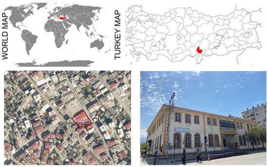
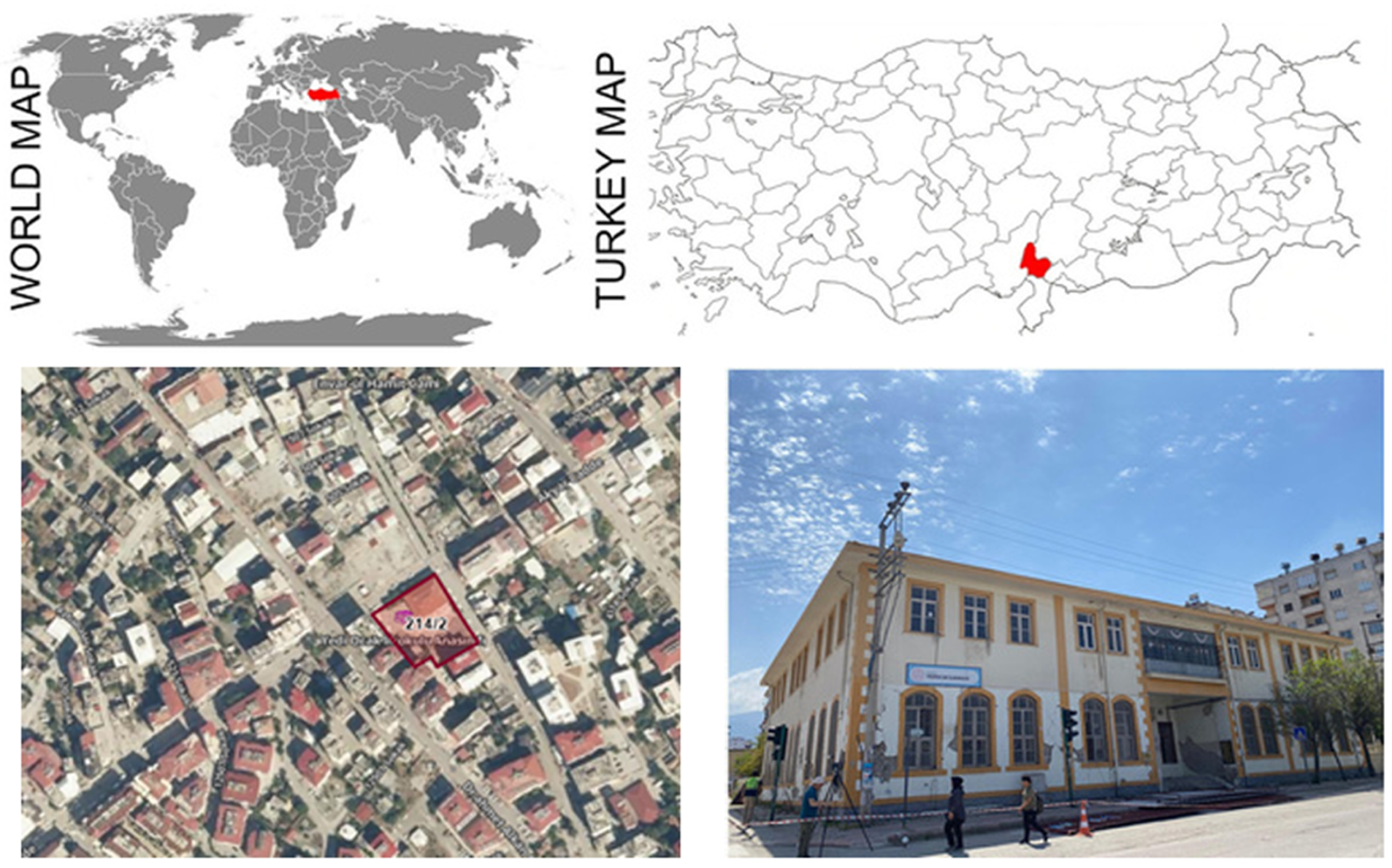
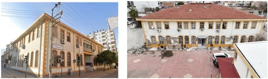
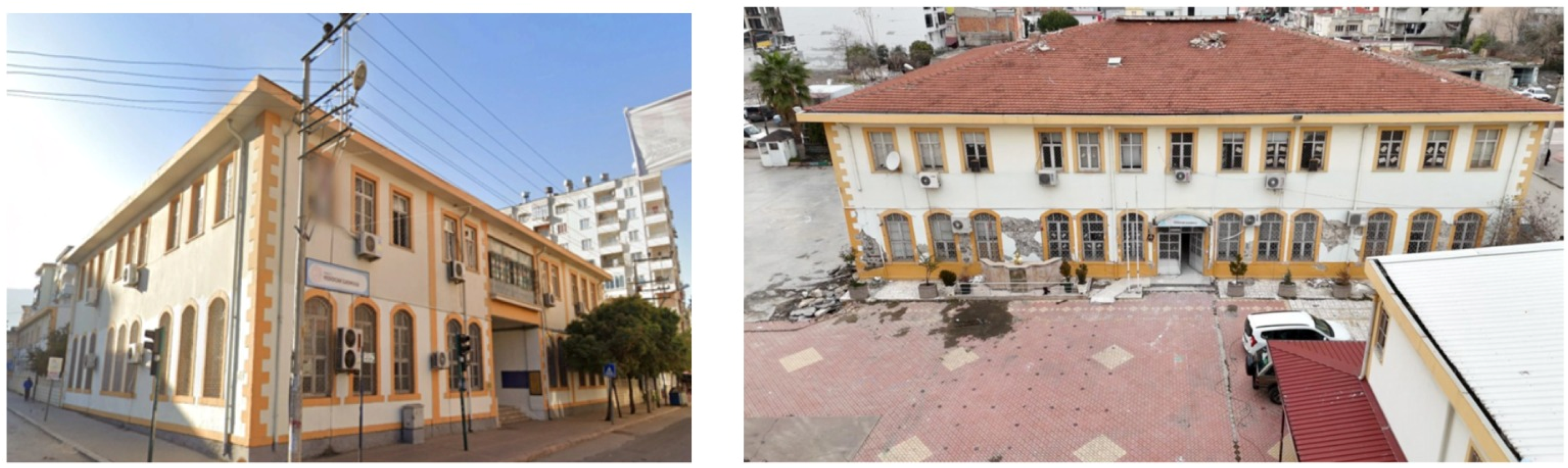
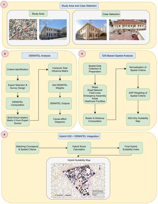
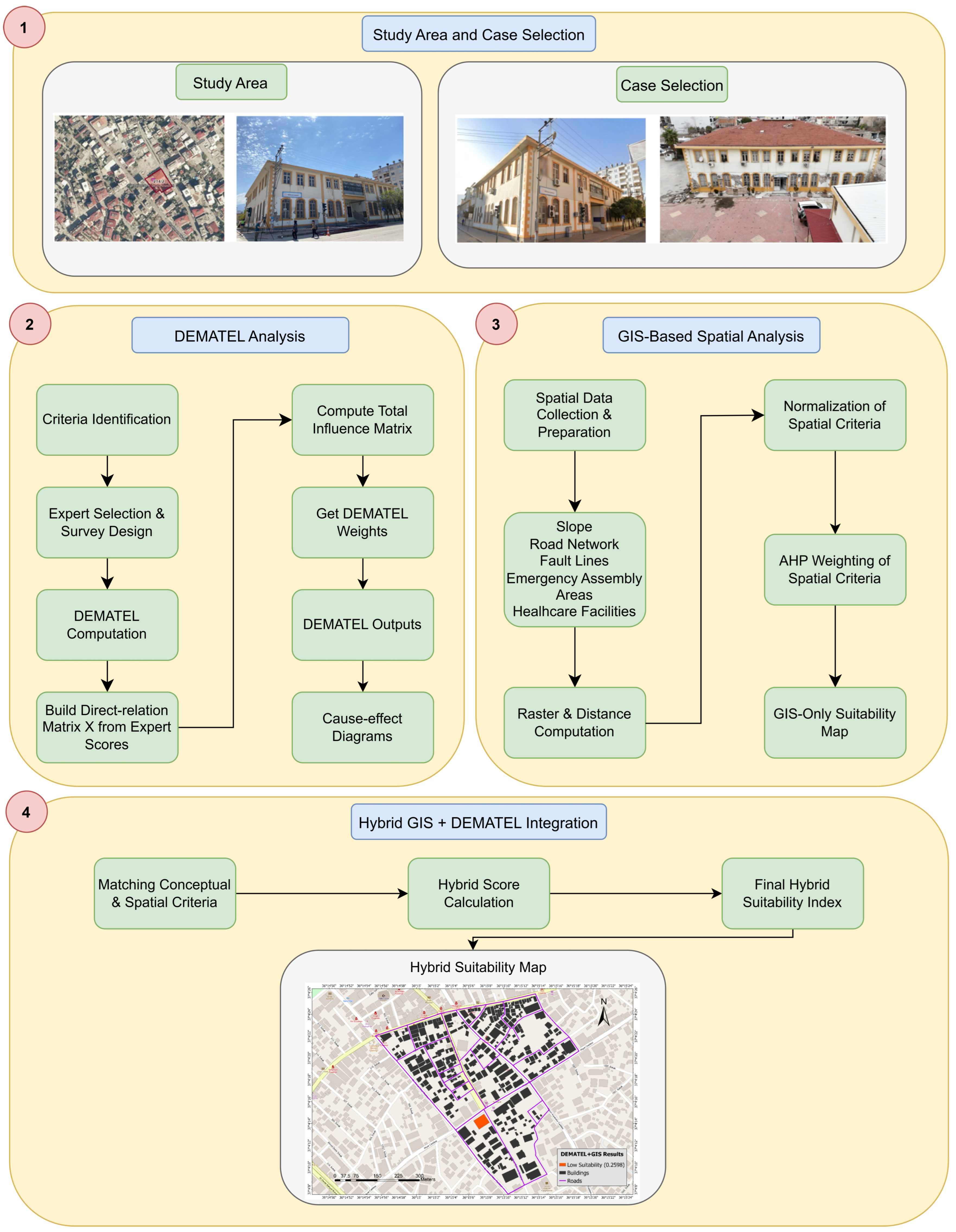
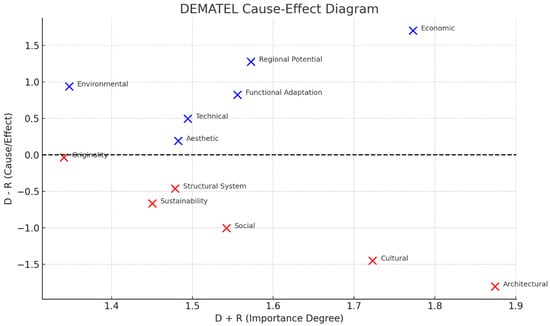
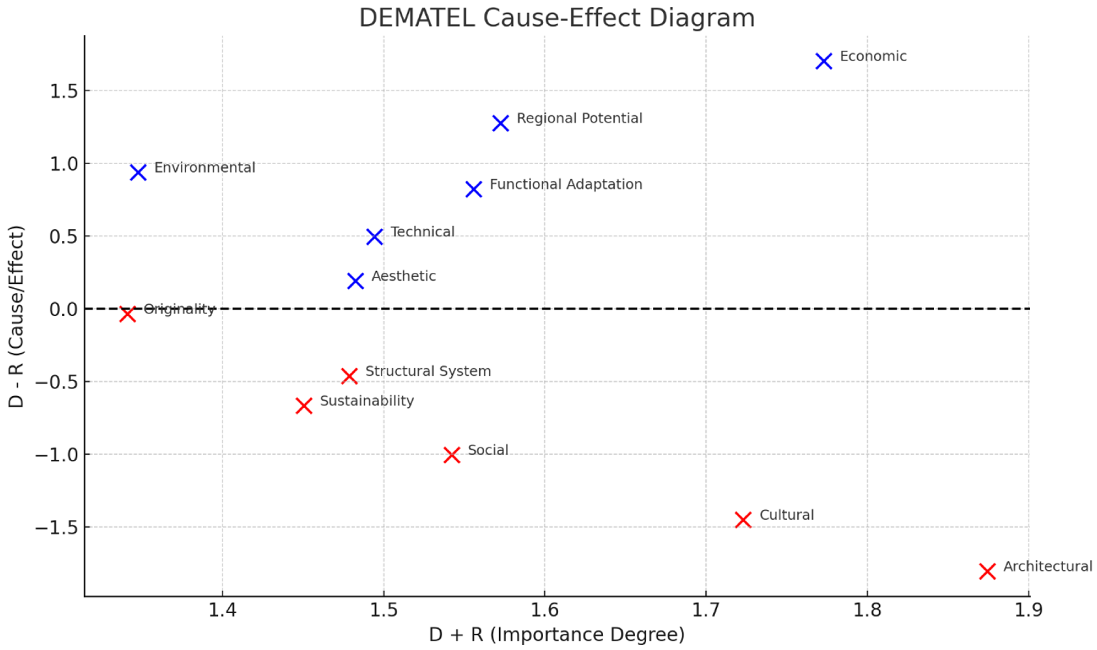
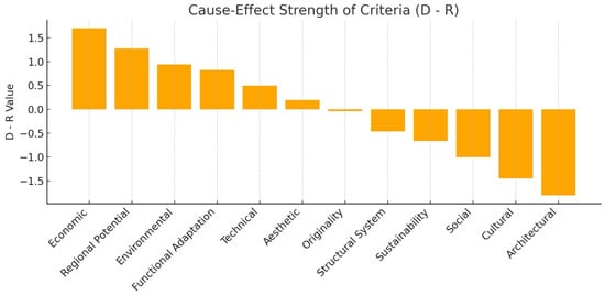
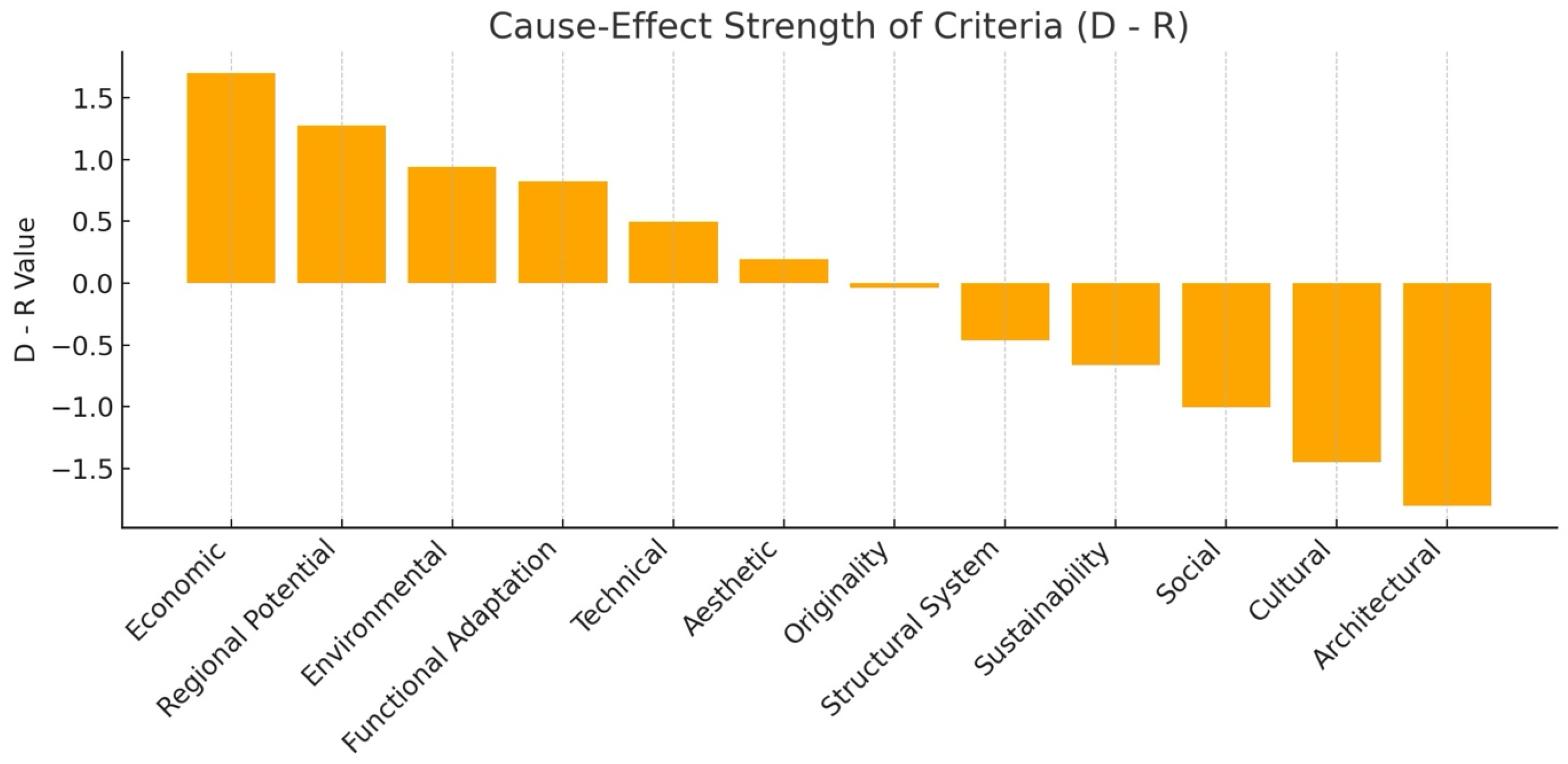
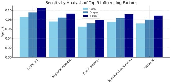
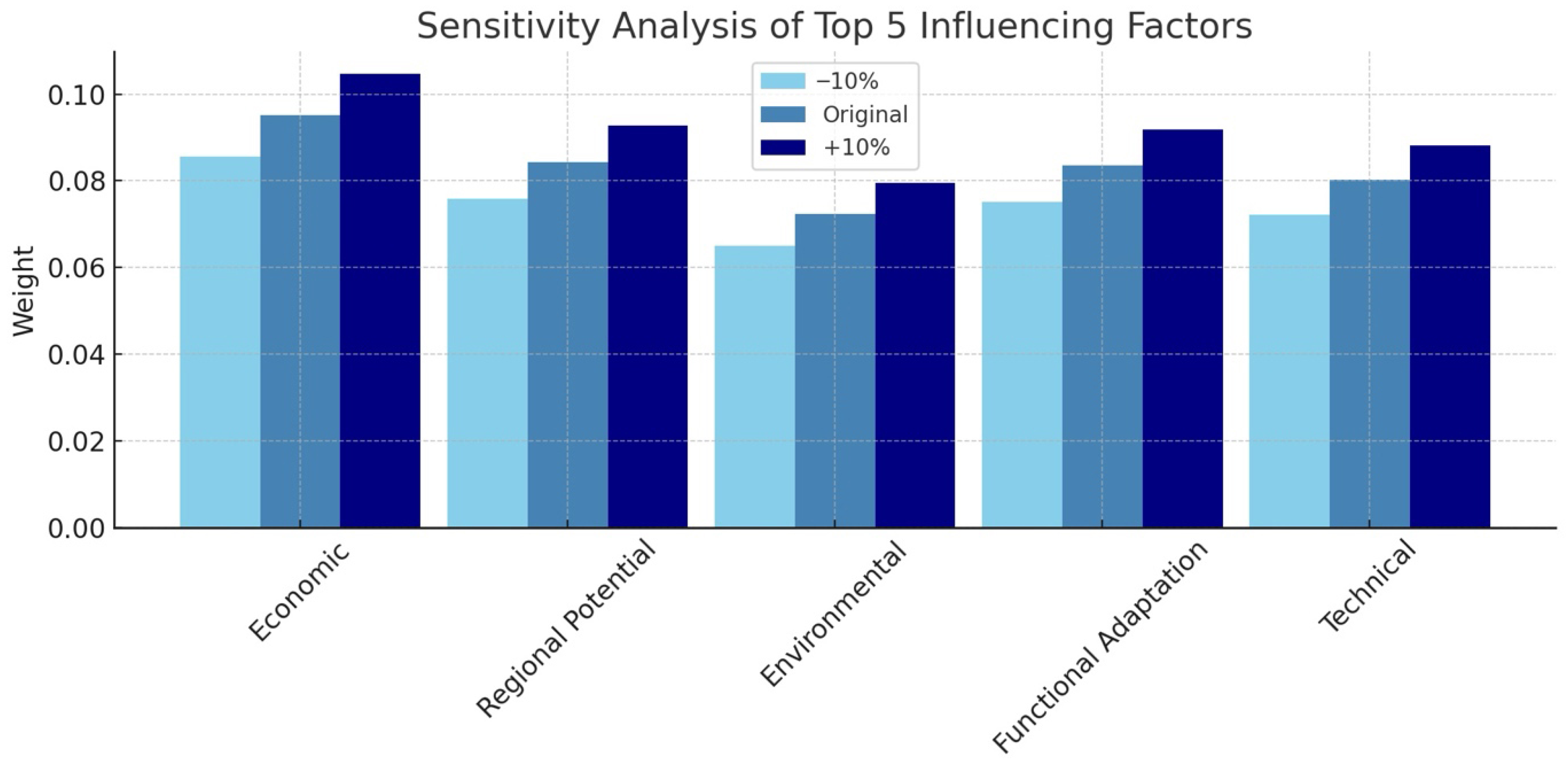
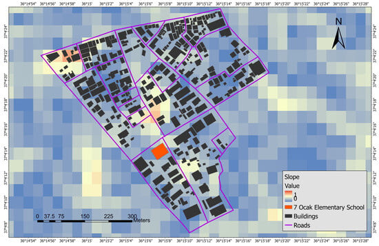
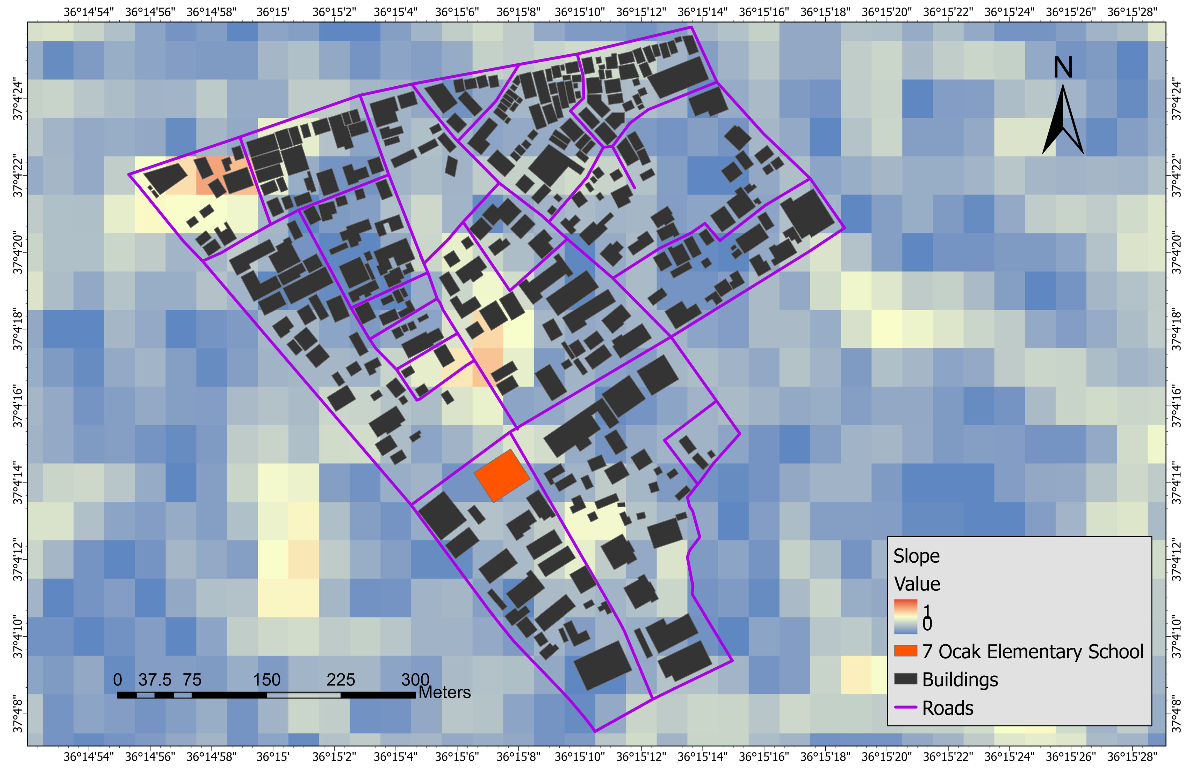
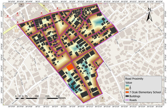
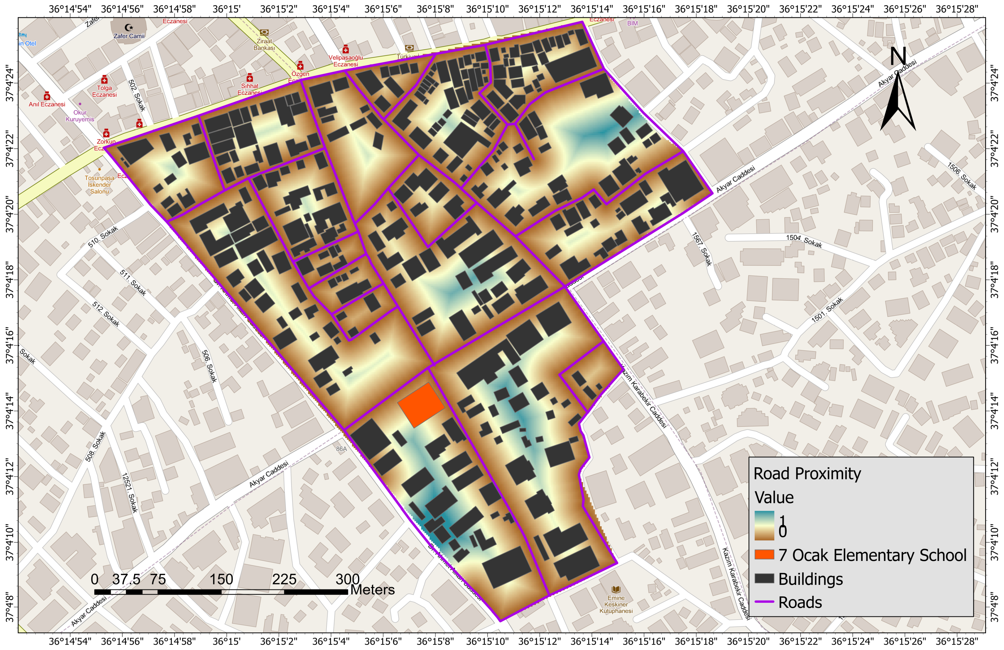
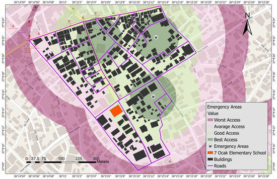
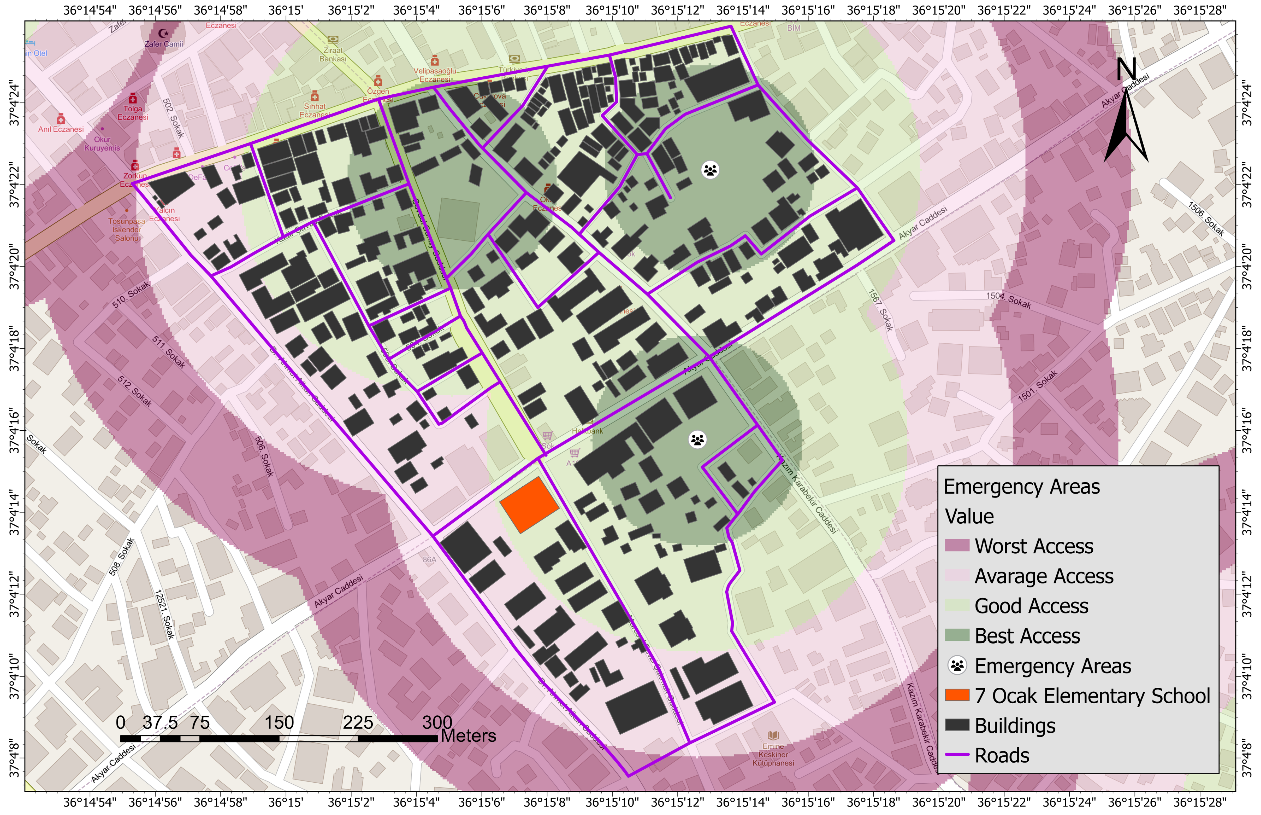
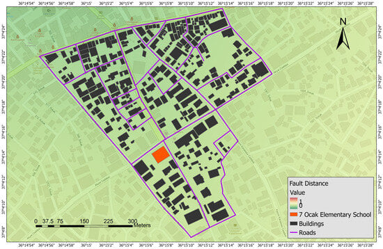
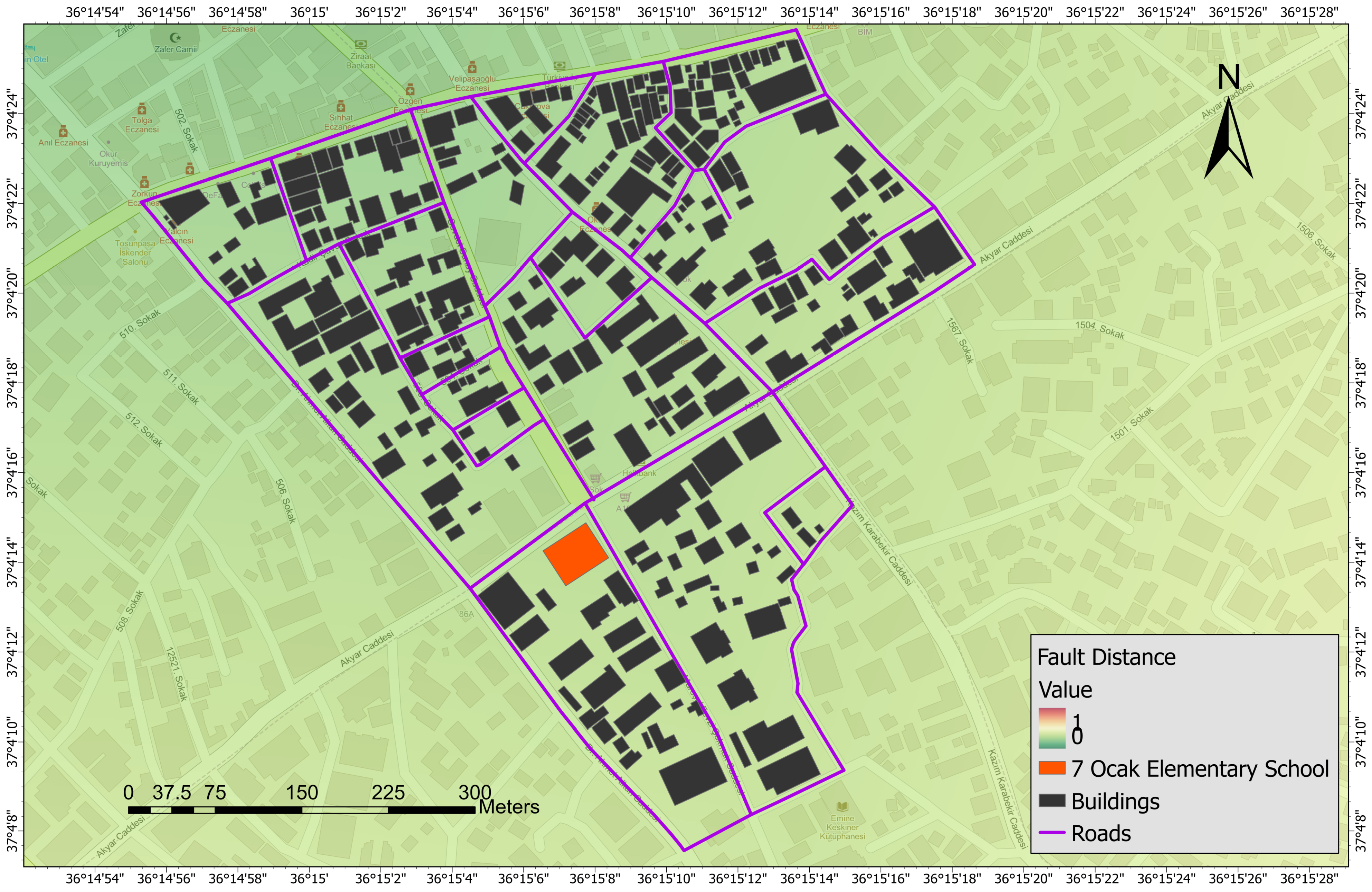
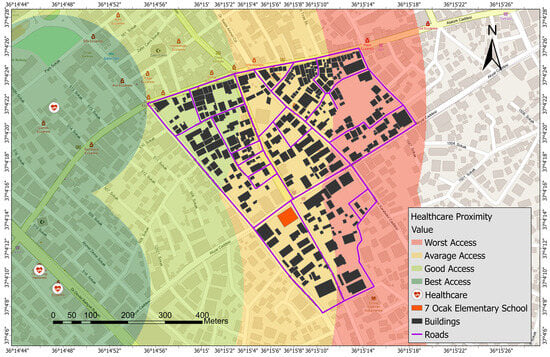
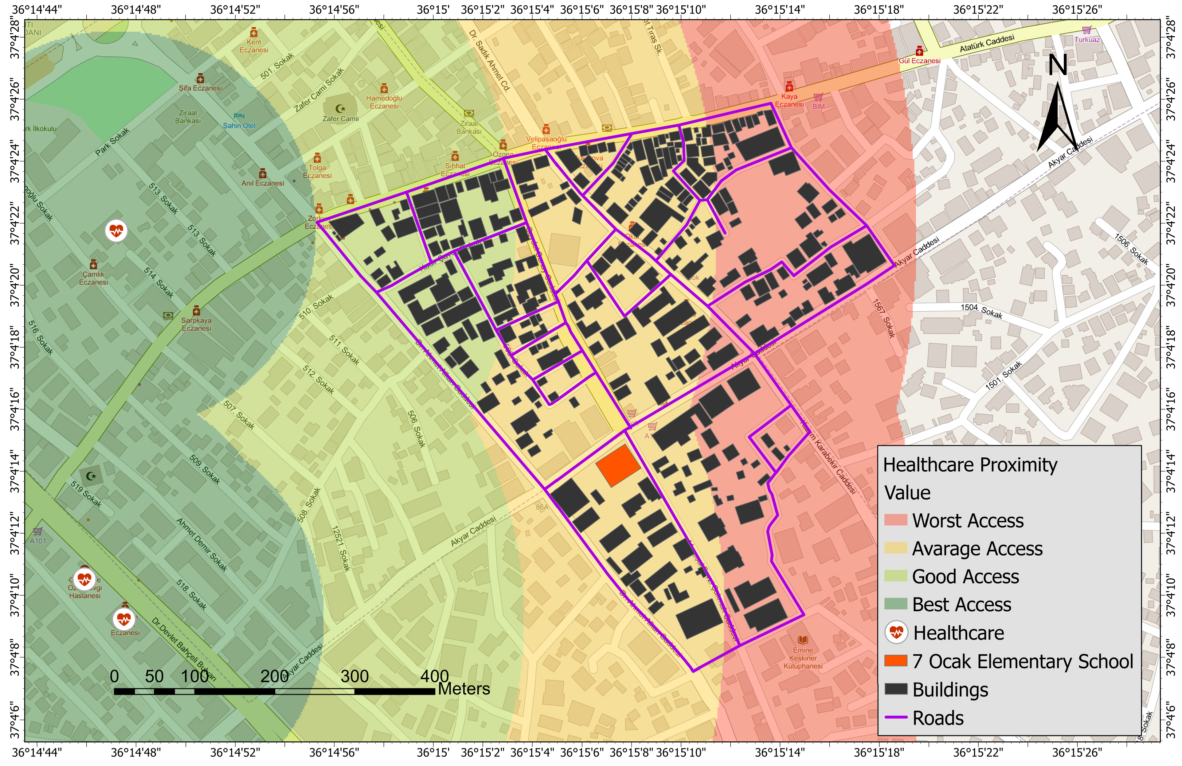
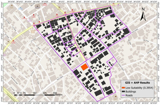
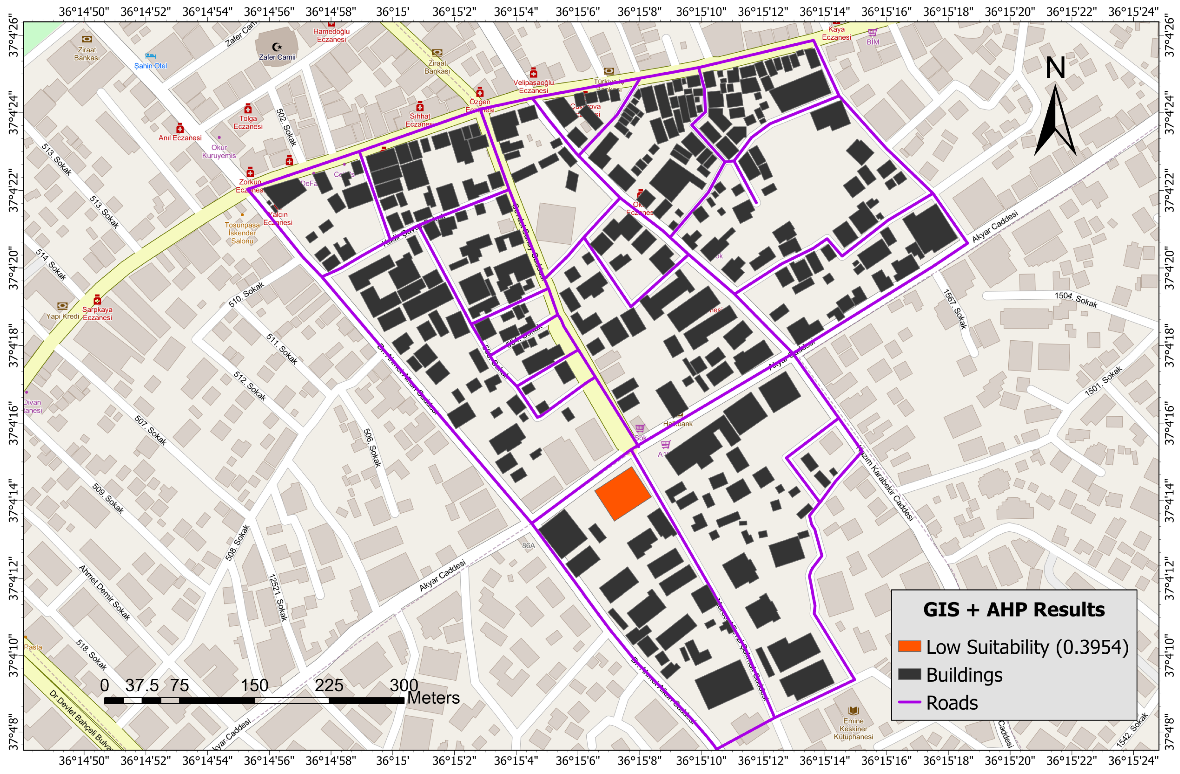
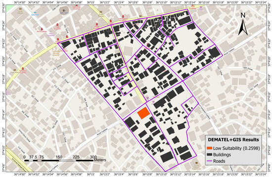
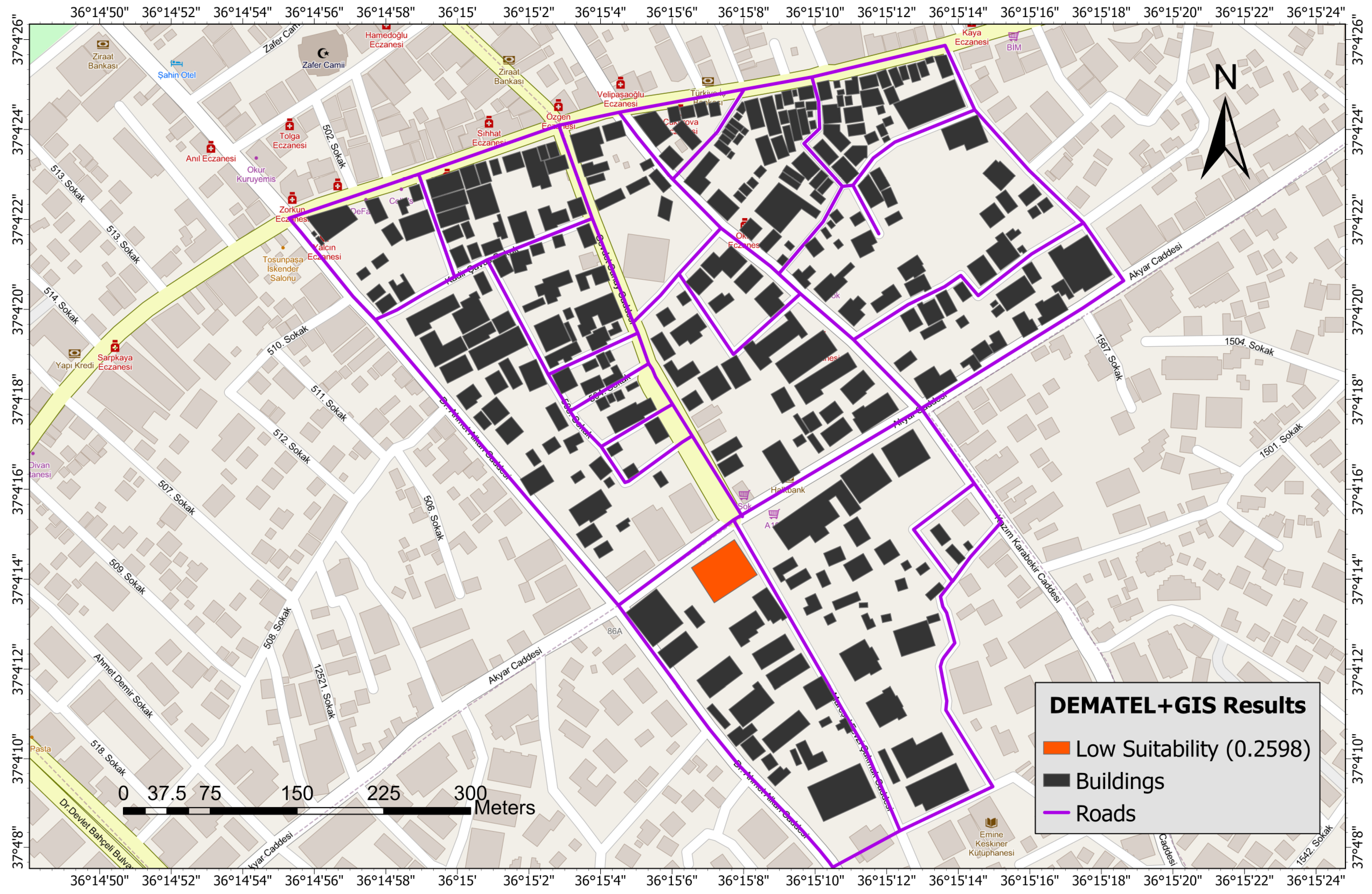


Disclaimer/Publisher’s Note: The statements, opinions and data contained in all publications are solely those of the individual author(s) and contributor(s) and not of MDPI and/or the editor(s). MDPI and/or the editor(s) disclaim responsibility for any injury to people or property resulting from any ideas, methods, instructions or products referred to in the content. |
© 2026 by the authors. Licensee MDPI, Basel, Switzerland. This article is an open access article distributed under the terms and conditions of the Creative Commons Attribution (CC BY) license.