


Abstract
The preservation and development of traditional villages are often affected by careless and scattered methods. The conservation paradigm has shifted from focusing on individual villages to regional clusters. This paper examines 275 national-level traditional villages in Henan Province, China, and develops an integrated identification–evaluation–strategy framework. First, cluster identification was performed using the three-dimensional indicator system that combined spatial, historical, cultural, and distinctive resources. This study identifies 16 traditional village clusters using K-means clustering and presents a unified spatial structure referred to as “one pole, three cores, four belts, and multiple points.” Based on cluster identification, a dual-dimensional evaluation system, including internal and external elements, was established to assess the development potential of the identified clusters. The external factors, including ecological resources, humanistic resources, and supporting conditions, were evaluated using a suitability evaluation. Simultaneously, the internal factors, i.e., value potential, spatial potential, and functional potential, were evaluated through the Cloud Model. Lastly, according to the evaluation results and unique resource analysis, the clusters were classified into five development typologies, with a corresponding strategy suggested for each. The integrated framework provides a replicable approach for clustered conservation and revitalization of traditional villages, offering scientific support for regionally integrated heritage management and sustainable rural development.
1. Introduction
Traditional villages, as a legacy of agrarian civilization, serve as the foundation for conserving cultural diversity and promoting sustainable rural development worldwide [1]. The role of traditional villages has also become more prominent in China within the national rural revitalization strategy. A total of 8155 villages are currently registered as national-level heritage sites in the country since the introduction of the national cataloging system for the conservation of traditional villages in 2012, making it the largest collection of agricultural cultural heritage in the world [2]. Since it was put in place, this initiative has achieved significant progress in saving and protecting several valuable heritage sites in villages [3]. Nevertheless, the constraints of the currently dominant model of conservation, the point-based system, in which the idea of conservation centers on the village, have become more evident with the experience gained. Such weaknesses include a scarcity of resource endowment, the absence of economies of scale, the inability to share infrastructure, and inadequate impetus toward sustainable industrial development. Consequently, such a fragmented strategy often fails to deliver long-term sustainability [4]. As a response, China introduced a national policy in 2020 to designate demonstration areas for the integrated conservation and use of traditional village clusters. This policy recommends an inclusive strategy in which geographically close, culturally linked, and complementary villages are treated as a whole and planned and developed in a unified way. This measure will transform China’s conservation strategy, which is currently point-based and focused on isolated preservation, towards a regional development pattern [5].
Historically, studies of traditional villages have focused on spatial distribution [6,7,8], spatial evolution [9,10,11], rural tourism [12,13], and cultural landscapes [14,15]. Nevertheless, their clustered development has attracted growing interest due to recent policy changes. The author suggests that traditional village cluster patterns are conditioned by agglomeration, connectivity, systemicity, and distinctiveness, according to Zhang et al. (2022), who state that the cluster model is an evolving process of preservation and development through the integration of both [5]. Using the information entropy model, Zhao et al. (2024) explore the geographical, cultural, and industrial interactions among regions affected by China’s existence [2]. Yuan et al. (2025) used a network science approach to identify traditional village clusters and core nodes and proposed a strategy in which core nodes would drive cluster development [16]. In a study that views traditional villages as contiguous areas, Fan et al. (2025) discuss methods for preserving and utilizing traditional villages through an empirical study of the Mentougou village cluster in Beijing [17]. There is consensus among scholars that the cluster model can serve as a scientific solution for achieving the synergistic development and preservation of traditional villages. However, much of the earlier work has focused narrowly on specific geographical regions or types of villages, and no extensive studies have been conducted on village clusters.
A key issue in the realization of contiguous protection of traditional villages is the identification of clusters. It aims to clarify groups of villages with common traits by uncovering spatial, cultural, and economic relationships, thereby providing a basis for decisions on contiguous protection [18]. Regarding identification, the method evolved from the initial one-dimensional model (spatial clustering) to a multi-dimensional model that incorporates spatial, cultural, economic, and ecological factors. For instance, Zhang et al. (2023) developed a three-dimensional identification system that integrates three elements: historical stratification, geographical features, and socioeconomic parameters [19]. The system categorizes 14 traditional villages in Zhejiang Province into four types. Shen et al. (2024) developed a three-dimensional identification system comprising spatial clustering, historical culture, and socioeconomics, which demarcates 12 priority protection zones and 6 general protection zones [20]. Dai et al. (2024) have proposed a 3-dimensional model of the correlation among geography, industry, and culture, which has been used to categorize 72 old towns and villages in Chongqing into 7 categories [21]. Spatial statistics, machine learning, network analysis, and knowledge graphs are applied in recognition technology. To illustrate this, techniques such as proximity indices, spatial network analysis, and multi-weight adjustment are used to assess the extent of interconnectivity among villages based on concepts of transportation, economic, and ecological weightings, accomplishing the task of cluster identification [22]. Kernel Density Estimation and Local Indicators of Spatial Association are used to identify clusters using ArcGIS spatial statistics and field verification techniques [23]. Technologies such as feature extraction, K-means clustering analysis, Neo4j knowledge graph construction, and multi-source data processing are used to visually retrieve clusters [24].
Evaluating the potential of traditional villages aims to identify their strengths and weaknesses, thereby facilitating the development of specific conservation and revitalization plans [25]. Current research primarily focuses on optimizing the evaluation system. To innovate evaluation procedures, researchers have developed a range of quantitative tools, including hierarchical entropy-weighted models and weighted TOPSIS models to assess the level of cultural heritage preservation in villages [26], and YOLOv10 and random forest models to evaluate their conservation condition [27]. There has also been a shift in research perspectives, moving beyond resource assessment frameworks towards complex systems analysis. Examples include the application of objective eye-tracking data to assess traditional village renewal [28], the evaluation of rural revitalization potential grounded in rural transformation and sustainability [29], and the factors of emotional perception—such as the sense of belonging and pride of village inhabitants—used as criteria to determine the sustainability of village development [30]. The research methodology demonstrates convergence across disciplines, including spatial analysis to study spatial changes in traditional villages [31], POI (Point of Interest) data to bridge data gaps [32], and social media data to assess the vitality of public spaces [33]. This indicates a shift in the assessment system for gauging the developmental potential of traditional villages. It is moving away from dynamic simulation-based testing and single-disciplinary analysis, and instead incorporates multi-technique testing, empirical judgment, and data-driven decision-making.
The conservation and development model of traditional villages in China is in a transitional phase, and the cluster-based approach is in its exploratory phase. Although current research has developed methodologies for cluster identification, a comprehensive and functional framework remains lacking. Such a framework should systematically bridge the delimitation of scientific clusters, the quantitative assessment of potential, and the development of differentiated strategies. As the central hub of agrarian Chinese civilization, Henan Province is both an urgent recipient of this change and a strong model for clustering preservation. Its highly heterogeneous topography, including mountains, plains, and hills, has resulted in a wide range of traditional villages that are spatially clustered [34]. Traditional villages in Henan Province have the advantage of clustered development. However, fragmented growth has occurred due to the lack of coordination between villages. This leads to poor resource distribution, an inability to create industrial synergies, a hindrance to cultural heritage preservation, and the deterioration of governance and the spatial–ecological environment.
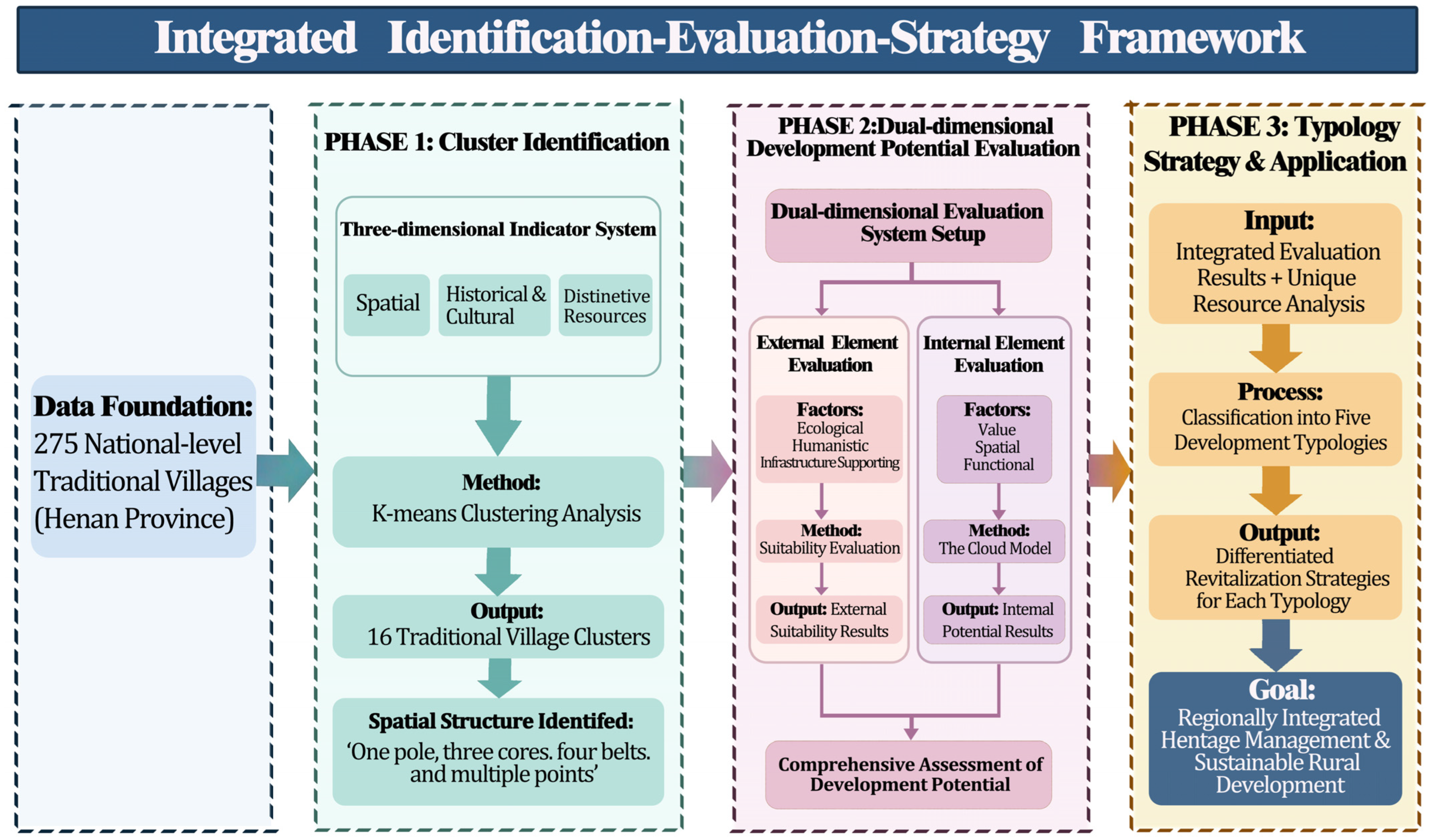
To address these issues, this paper focuses on 275 national-level traditional villages in Henan Province and develops an integrated identification–evaluation–strategy framework, illustrated in Figure 1. This is a three-stage model: (1) establishing a three-dimensional identification system that combines spatial, historical and cultural, and distinctive resources to define village clusters using K-means clustering analysis; (2) creating a dual-dimensional evaluation system to assess development potential, considering external factors (e.g., ecological resources, humanistic resources, supporting conditions) and internal factors (e.g., value potential, spatial potential, functional potential) with the help of suitability evaluation and the Cloud Model, respectively; and (3) classifying the identified clusters using synthesized results.
Figure 1.
Integrated framework for the identification of traditional village clusters, the evaluation of their development potential, and the formulation of typology-specific revitalization strategies.
This research aims to develop a replicable, scalable scientific approach that provides theoretical and methodological guidance for the centralized, sustainable conservation and use of traditional villages in China.
Compared with previous studies, this paper proposes three core innovations and marginal contributions. First, the innovation of the research framework. Existing studies are mostly limited to single-dimensional village cluster identification or potential evaluation. This paper breaks through such limitations and constructs an integrated closed-loop research framework of “cluster identification–potential evaluation–typological strategy”, achieving a full-chain and systematic analysis of the protection and revitalization of traditional village clusters. Second, the innovation of the indicator system. Based on the regional characteristics of traditional villages in the Central Plains, a cluster identification indicator system is established from three dimensions, spatial pattern, historical culture, and characteristic resources, which compensates for the deficiencies of single-dimensional indicators and poor regional adaptability in existing studies. Third, the innovation of research methods. By integrating the complementary strengths of GIS-based external suitability evaluation and cloud model-based internal fuzzy evaluation, this study considers the randomness and fuzziness of regional macro resource endowments and microscopic village attributes, which significantly improves the accuracy and scientificity of the evaluation and classification results of traditional village clusters.
2. Research Area and Data Sources
2.1. Research Area
Henan Province is located on the North China Plain (31°36′ N, 110°16′ E), with terrain sloping eastward. The Taihang, Funiu, Dabie, and Tongbai Mountains define its northern, western, and southern boundaries, while alluvial plains formed by the Yellow, Hai, and Huai Rivers dominate the eastern, northeastern, central, and southeastern regions—collectively known as the Huang–Huai–Hai Plain. The Nanyang Basin lies in the province’s southwest.
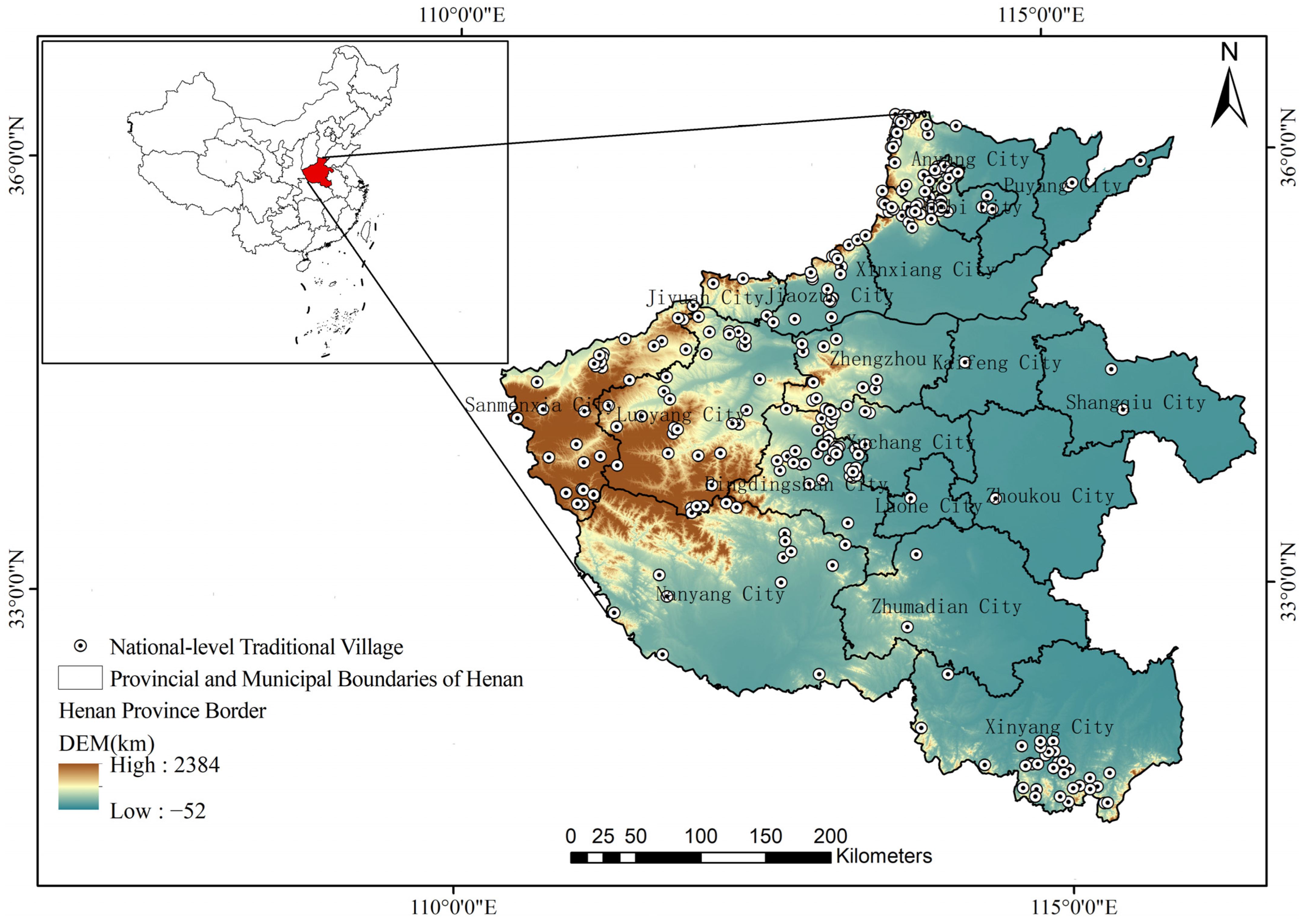
Henan, known as the cradle of Chinese civilization, was home to ancient communities along both banks of the Yellow River as early as the Neolithic era. The province features archeological sites from the renowned Yangshao, Erlitou, and Longshan cultures. According to six batches of traditional village lists published by the Ministry of Housing and Urban-Rural Development of China, Henan has 275 national-level traditional villages. These villages are highly concentrated, primarily in the northern, central, and southern regions, with fewer in the eastern area (Figure 2).
Figure 2.
Map of Henan Province’s Location and Distribution of National-Level Traditional Villages.
2.2. Data Sources and Processing
This research gathered a large amount of data, including cluster identification data and development potential evaluation data. The data is categorized into three main groups based on its use: cluster identification data, external factor data, and internal factor data (Table 1). The types of data, along with their dimensions and quantities, vary. Therefore, to assess the validity and scientific rigor of the clustering and evaluation results, standardization of the initial indicators is necessary. Table 2 presents the relevant data processing methods.
Table 1.
Data Sources.
Table 2.
Data Processing Methods.
3. Cluster Identification
This research focuses on developing a cluster identification system for traditional villages in Henan Province. It uses K-means clustering analysis to determine village clusters based on three criteria: spatial distribution, historical and cultural characteristics, and unique resources.
3.1. Construction of Clustering Indicator Systems
The spatial, historical, cultural, and distinctive resources were identified as key factors in determining traditional village clusters through a review of extensive literature, expert interviews, and field research. Based on the relationships between villages and the quantifiability and reliability of the sources, ten secondary indicators were identified and further divided into forty tertiary indicators. The result of this process was a systematic, comprehensive indicator system for identifying traditional village clusters (Table 3).
Table 3.
Cluster Identification Indicator System.
3.2. Technical Route of Cluster Identification
The identification of traditional village clusters in this study follows a complete technical procedure of “data collection–spatial visualization characterization–clustering calculation–secondary optimized aggregation”. The specific steps are as follows:
- Acquisition of basic spatial data. The precise geographic coordinates of 275 traditional villages in the study area are extracted via Google Earth Pro. The coordinate data are imported into the ArcGIS 10.7 platform to generate a vector layer of village spatial distribution, which provides basic fundamental data for subsequent spatial correlation analysis.
- Sorting and assignment of multi-dimensional attribute data. Based on local chronicles, genealogy documents, publicly released government data at all levels, and field investigations, this study systematically collects historical and cultural data of traditional villages, including historical evolution and village construction context, as well as characteristic resource data covering village cultural landscapes, ecological landscapes, and cultural heritage. All data are uniformly converted into standard vector attribute data and assigned to corresponding village points.
- Visual characterization of multi-dimensional correlation features. Based on the ArcGIS 10.7 platform, visualized expression is conducted on three types of data, namely spatial distribution, historical culture, and characteristic resources. It intuitively reveals the spatial correlation, cultural context correlation, and resource correlation characteristics of traditional villages in Henan Province, providing feature support for cluster identification and judgment.
- Primary clustering and grouping. With the multi-dimensional resource correlation features as input parameters, the K-means clustering algorithm embedded in SPSS 22.0 software is adopted to group sample villages. Villages with highly similar spatial, cultural and resource attributes are classified into the same cluster unit.
- Secondary aggregation optimization and cluster determination. On the basis of primary clustering results, secondary aggregation classification and clustering pruning optimization are carried out by comprehensively considering village spatial distance, resource proximity, traffic correlation and other factors. Finally, the cluster system of traditional villages in Henan Province is established, and the visual output of the cluster spatial pattern is realized.
3.3. K-Means Clustering Analysis
The K-means clustering model is an unsupervised machine learning tool. Its fundamental idea is that it subdivides a set of points into K clusters so that the similarity between points within a cluster is as high as possible and the similarity between points across clusters is as low as possible. The objective function aims to minimize the sum of squared distances between each data point and the center of the cluster. The formula is as follows:
where K is the number of clusters, is the k-th cluster, is the sample point of the cluster , is the center point of the cluster , and is the squared Euclidean distance between the sample point and the center point .
K-means clustering of standardized data was performed in SPSS to determine the optimal number of clusters for traditional villages in Henan Province. The process involved several steps:
- Setting and Iterative Testing of the K-value: The K-value range was set between 10 and 20 based on traditional village locations. Multiple cycles of iterative testing were conducted using SPSS K-means clustering, with each iteration recorded and the within-cluster sum of squares (SSE) calculated. A lower SSE indicated higher within-cluster similarity and improved clustering performance (Table 4).Table 4. Cluster Iteration Record.
- Optimal K Value: When K = 15, the sample distribution per cluster stabilized and SSE reached its minimum, reflecting the highest intra-cluster similarity and greatest inter-cluster differences. Thus, K = 15 was selected as the optimal solution.
- Validity of Clustering Results: ANOVA in SPSS showed that, except for a few indicators (e.g., residential layout), the remaining 40 indicators had p-values < 0.001, indicating significant differences across clusters and confirming that the K = 15 solution is scientifically valid for differentiating traditional villages in Henan Province (Table 5).Table 5. ANOVA Table.
In this study, the K-means iteration results converged completely after 14 iterations, and the cluster centers no longer changed, indicating that the classification structure reached a stable state. Combined with the minimum SSE and significant ANOVA test results, the clustering scheme of K = 15 is proven to be the global optimal solution rather than a local optimal solution.
4. Development Potential Evaluation
In order to assess the development potential of villages in Henan Province, this paper uses a dual-dimensional evaluation system comprising external and internal aspects. The macro level of the traditional village clusters is examined through external factor analysis, which helps to assess the resource base of the village clusters. The micro level is examined through internal factor analysis, which helps to assess the intrinsic features of these villages. Suitability assessment methods are used in the external factor assessment. It is a powerful solution for coordinating information from several indicators by rasterizing different variables using GIS technology and applying overlay analysis. The cloud model used in internal factor analysis is a mathematical expression of the correlation between fuzziness and randomness among entities, allowing the evaluation to be both qualitative and quantitative.
4.1. Evaluation System Construction
Based on applicable regulations and literature analysis, and considering the validity of the data collection and the representativeness and commonality of the indicators, an assessment system for traditional village clusters in Henan Province was established (Table 6). The external factor evaluation criteria, adopting a cluster perspective, include ecological resources, cultural resources, and supporting conditions. The internal factors are divided into three dimensions: value potential, spatial potential, and functional potential, based on the characteristics of traditional villages’ value, preservation, and usage conditions. Using a mixed-method approach combining the Analytic Hierarchy Process (AHP) and the entropy weight method, several rounds of consultation were held with seven professors and associate professors specializing in urban and rural planning, landscape architecture, and architecture. The subjective weights derived from AHP and objective entropy weights are integrated via linear weighting. The final weights of each evaluation indicator were thus determined, and the total scores were subsequently calculated.
Table 6.
Evaluation Indicator System for Traditional Village Clusters in Henan Province.
4.2. Suitability Evaluation Process
The suitability evaluation for Henan Province follows a structured, three-stage process.
4.2.1. Establishing a Unified Evaluation Framework
Drawing on classic studies of traditional villages, this study adopts a 10 km analysis scale to characterize the interactive relationships and resource radiation ranges of rural settlements [35,36]. In compliance with the requirements of suitability evaluation and local regional conditions, the entire territory of Henan Province is divided into regular grids of 10 km × 10 km as basic evaluation units. This setup enables multi-index analysis at a uniform spatial scale and avoids evaluation errors caused by spatial heterogeneity.
4.2.2. Single-Factor Analysis and Standardization
Each evaluation indicator is processed to remove dimensionality and enable direct comparison:
- Ecological Resource Indicators:Based on expert judgment and the GIS natural breaks classification method, the indicators are divided into five grades. For instance, areas with an elevation above 1000 m are classified as “suitable”, while those below 100 m are “unsuitable”, with standardized scores ranging from 1 to 5 assigned to each grade, respectively.
- Humanistic Resource Indicators:For point and area resources (such as scenic spots and cultural heritage sites), suitability is assessed based on proximity. The Euclidean distance from each grid cell to the resource is calculated using ArcGIS tools, then reclassified into five levels—shorter distances receive higher standardized scores (1 to 5).
- Supporting Condition Indicators:Facility data (e.g., POI counts per grid cell), road density, population, and GDP are spatially allocated and analyzed. These measures are also categorized and standardized on a 1 to 5 scale according to their relative magnitude.
4.2.3. Integrated Potential Calculation and Grading
All indicator factors are reclassified using GIS tools. The standardized uniform data ranging from 1 to 5 after dimensional normalization are subjected to weighted summation via the overlay analysis tool to obtain the baseline evaluation results of external factors. The overall composite scores are unified within the range of 1 to 5; a higher score indicates superior suitability of external resources and better development conditions.
Taking a 10-km buffer radius, the evaluation values around each traditional village are statistically calculated based on the baseline evaluation results, and the weighted average is adopted to derive the composite external factor scores of the 16 clusters. In light of the natural fracture characteristics of the dataset, the Natural Breaks Classification method is applied to categorize the composite scores into five potential levels, with specific grading criteria as follows:1.00–1.79 (Extremely Low), 1.80–2.59 (Low), 2.60–3.39 (Medium), 3.40–4.19 (High), 4.20–5.00 (Extremely High).
4.3. Cloud Model Evaluation Method
4.3.1. Establishment of the Evaluation Model
Depending on the type of indicator, different approaches were used to convert raw data into scores ranging from 0 to 100, which serve as the basis for computing cloud parameters (Table 7). There are two types of indicator factors: ① Subjective indicators, which are not easily measurable, such as “Completeness of Village Style and Features” and “Distinctiveness of Traditional Buildings.” All seven experts scored independently. During data processing, extreme scores were excluded, and the original scores from the four-point scale were uniformly converted into standardized scores ranging from 0 to 100. ② Objective indicators, which are directly measurable, such as the richness of historical elements and the abundance of preserved cultural relics, among 7 other indicators. These scores are normalized using the Min–Max method based on their raw values.
Table 7.
Internal Factor Evaluation Criteria.
4.3.2. Building a Standard Cloud Model
A four-tier evaluation system was established to specify the numerical ranges and cloud characteristics for each category: poor potential, average potential, high potential, and very high potential. This standardized cloud model provides the foundation for later comparative analyses. Detailed classification criteria are provided in Table 8.
Table 8.
Internal Factor Standard Layer Construction.
The cloud model defines the uncertainty of qualitative concepts using three parameters: E (Expectation), E (Entropy), and H (Hyperentropy).
Ex: Rep is the essential numerical value used for a given level of evaluation and represents the quantitative measure of qualitative notions. In this study, the central score for the ‘High Potential’ level is Ex = 62.5. En: En reflects the level of ambiguity in qualitative concepts. An increase in En indicates blurred boundaries between levels. In this work, En is set to 4.167, corresponding to the level interval width divided by 6. The interval width for “high potential” (50, 75] is 25, and the width for each level is 50/6, or 0.4167. This aligns the uncertainty of the level boundaries with the evaluation requirements. He: He accounts for the variability or fluctuation of En, reflecting the range of fuzziness. A smaller He value indicates more consistent evaluation results. In this study, He = 0.5 is chosen based on expert experience and preliminary experiments to balance evaluation accuracy and flexibility.
4.3.3. Calculation of Comprehensive Evaluation Parameters
Firstly, the parameters of clouds of individual indicators are determined. The cloud feature parameters of the score for each indicator (Ex, En, He) are calculated using the reverse cloud algorithm, based on which the uncertainty distribution of the qualitative concepts is obtained from the quantitative scores. Since the score of a single indicator is fixed, Ex = indicator score. En is defined as half of the standard deviation of the scores to account for the randomness in subjective indicator ratings or statistical errors in objective indicator data. In this research, the standard deviation of subjective indicators ranges from 5 to 8, while that of objective indicators ranges from 3 to 5. Hyperentropy (He) is proportional to the variation in En and is defined as He/10 to manage randomness. As a result, each indicator is associated with a specific set of cloud parameters (Ex, En, He), and the single score is converted into an uncertainty distribution.
Next, the cloud parameters at the criterion and synthesis levels are derived from the single-indicator cloud parameters to create a comprehensive evaluation cloud for the internal elements of each cluster, enabling holistic quantification of internal potential. These cloud parameters are a weighted aggregation of the subordinate parameters, following the linear weighting rule as shown in the formula below:
where , , denotes the cloud parameter for indicator i, and denotes the weight for indicator i. En and He represent the standard deviation, which must be weighted by variance.
4.3.4. Cloud Map Generation and Potential Matching
The obtained composite cloud parameters are imported into MATLAB 2024b to generate internal factor cloud assessment images for each cluster. The scores are displayed on the horizontal axis, and the degrees of membership are shown on the vertical axis, with four possible levels marked. The final comprehensive potential of internal factors for each cluster was calculated via weighted overlay of three criterion layers: value potential, spatial potential and functional potential. Potential grading was determined by matching scores against the four-level cloud interval criteria predefined in Table 6: Poor Potential [0, 25], Average Potential [25, 50], High Potential [50, 75], and Very High Potential [75, 100].
4.4. Coupling of Internal and External Potentials and Cluster Classification
To realize differentiated type identification of traditional village clusters and match targeted revitalization strategies, this study classifies clusters using a two-dimensional matrix coupling method. Taking external suitability grades as the horizontal dimension and internal potential grades as the vertical dimension, we established a full-coverage combinatorial identification framework. Based on unified grading criteria, the internal and external grades of the 16 traditional village clusters were matched one by one. Invalid combinations without sample coverage were eliminated, while valid coupling types were retained. Finally, the classification of all village clusters was completed. This work also provides a standardized methodological basis for the subsequent formulation of differentiated development models and strategy optimization.
5. Result
5.1. Results of Traditional Village Cluster Identification
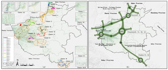
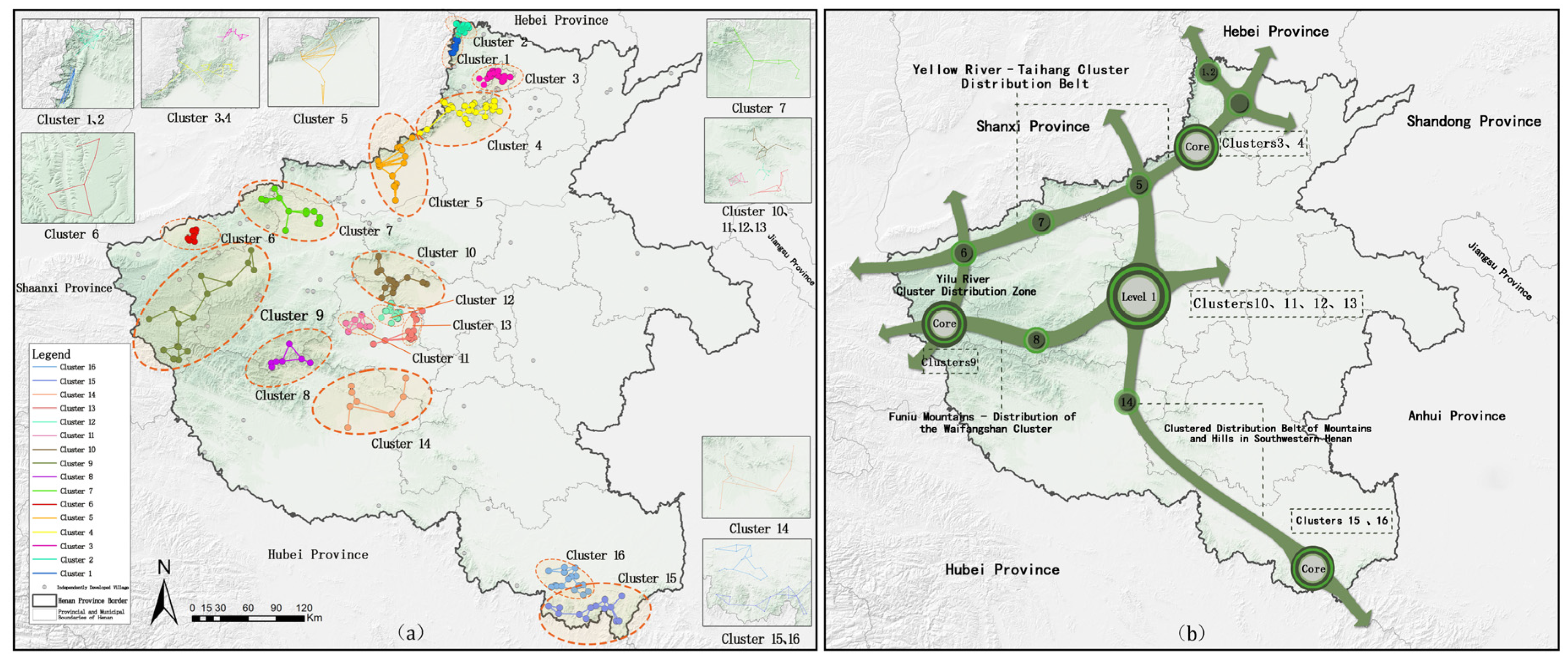
Based on the 15 clusters generated by K-means clustering, geographical factors, including the distribution of nearby resources, transportation accessibility, and natural barriers, were comprehensively considered. Villages with weak spatial associations to the main clusters were excluded, and some clusters were split into two independent groups after removing isolated villages. As a result, the 15 clusters were optimized into 16 traditional village clusters. The spatial distribution data for these 16 clusters were imported into ArcGIS 10.7, producing a visual representation of the distribution of traditional village clusters in Henan Province (Figure 3).
Figure 3.
Results of Traditional Village Cluster Identification in Henan Province: (a) Spatial clustering and distribution of traditional village clusters. (b) Point–axis spatial structure of traditional village clusters.
Through ArcGIS spatial analysis, the 16 clusters display a geographic distribution pattern characterized by “one pole, three cores, four belts, and multiple points.” This distribution is similar to the kernel density map, in which the concentration of traditional villages can be observed throughout the central, northern, western, and southern regions of Henan, with few in the eastern region. Furthermore, with respect to the national list of Demonstration Zones for the Concentrated and Connected Protection and Utilization of Traditional Villages, it can be seen that all these zones are concentrated in the cores or distribution clusters. This further validates that the clustering results are consistent with the actual conservation requirements and provide practical guidance.
5.2. Potential Evaluation Results
5.2.1. Evaluation Results of External Factors
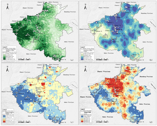
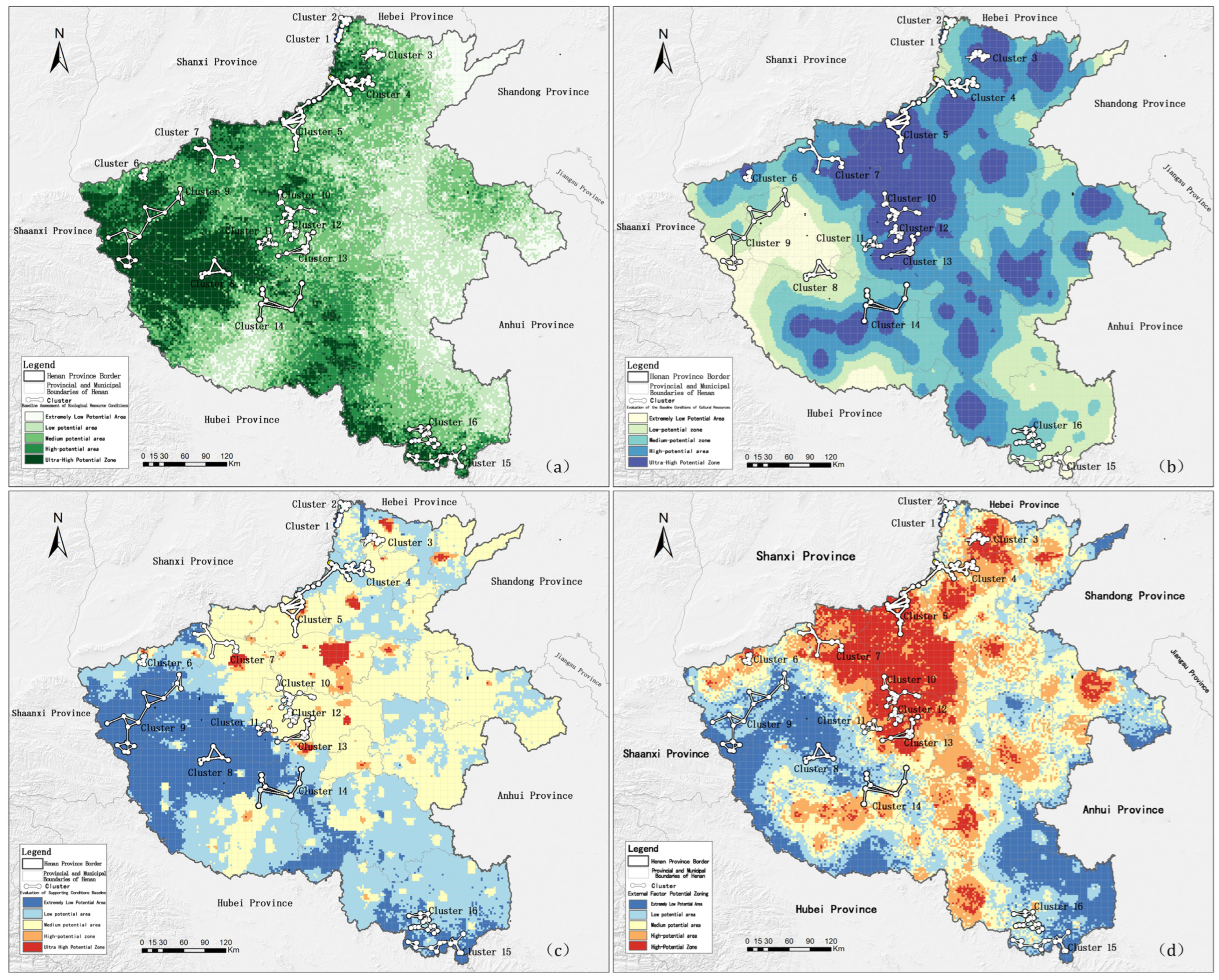
Suitability evaluation was performed to generate the baseline assessment of external factors for traditional village clusters in Henan Province (Figure 4). The comprehensive evaluation results of external factors for Henan’s traditional village clusters were summarized in Table 9 according to the potential grading of external factors. The discussion indicates the following:
Figure 4.
Evaluation Results of External Factors: (a) Evaluation of Ecological Resources; (b) Evaluation of Humanistic Resource; (c) Evaluation of Supporting Conditions; (d) External Factor Evaluation of Traditional Village Clusters in Henan Province.
Table 9.
Evaluation of external elements of traditional village clusters in Henan Province.
- Five clusters in Henan Province possess extremely high external factor potential, including Cluster 3, Cluster 5, Cluster 10, Cluster 12, and Cluster 13. The potential humanistic resource conditions in these clusters are usually extremely high, whereas the ecological resource conditions are high or medium. Regarding the conditions that need to be supported, Cluster 3 has high potential, while the rest have medium potential. This implies that the strengths of such clusters lie in the abundance of humanistic resources and the favorable ecological conditions. To develop a better supporting environment, development strategies must leverage these benefits.
- Cluster 4, Cluster 6, Cluster 7, and Cluster 11 have high potential for external factors. These high-potential clusters also have great developmental potential in both ecological and humanistic resource conditions, but the supporting conditions are not as robust as those of extremely high-potential clusters. They can make the most of what they have to offer by leveraging favorable resource conditions.
- Cluster 14 has medium potential for external factors.
- The three clusters with low potential, i.e., Cluster 1, Cluster 2, and Cluster 16, have rather favorable ecological resource conditions and are the points of future development.
- The three clusters (Cluster 8, Cluster 9, and Cluster 15) that have extremely low potential indicate rather high ecological resource conditions in comparison to their humanistic resource conditions and supporting conditions. Such clusters should develop using strategies that focus on protecting the ecological environment.
5.2.2. Internal Factor Evaluation Results
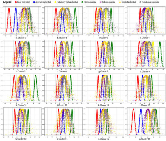
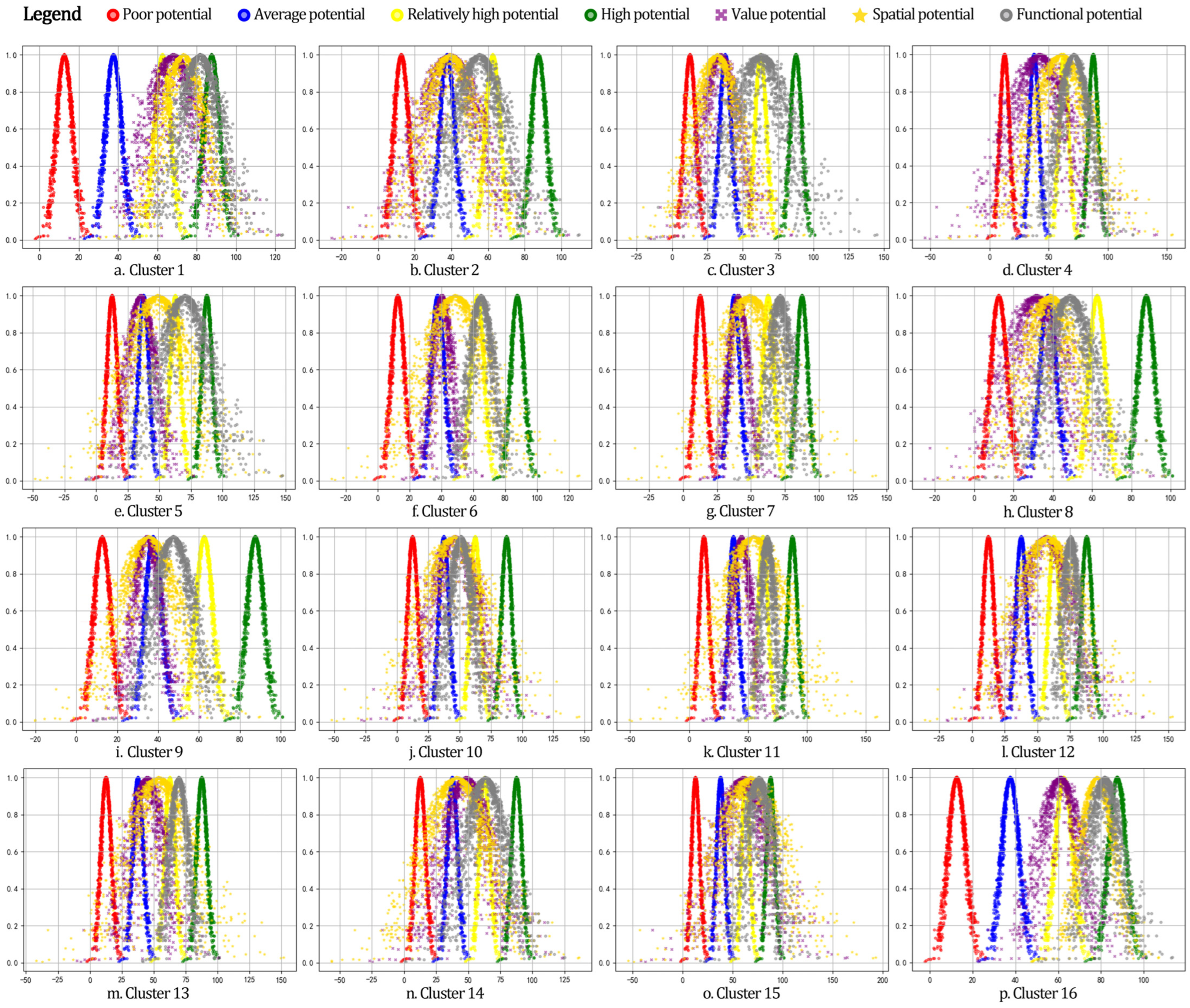
The cloud model evaluation provides the internal factor cloud evaluation map for traditional village clusters in Henan Province (Figure 5). The evaluation results are as follows:
Figure 5.
Cloud Evaluation of Internal Elements in Traditional Village Clusters of Henan Province.
- Value Potential: Twelve clusters have average value potential, while four clusters have high Value Potential. Clusters 12, 15, 16, and 1 have high-value potential.
- Spatial Potential: There are nine clusters with average spatial potential and six clusters with high spatial potential, i.e., Cluster 13, Cluster 11, Cluster 12, Cluster 4, Cluster 15, and Cluster 1. Also, Cluster 16 has very high spatial potential.
- Functional Potential: Two clusters have average functional potential, ten clusters have high functional potential, and four clusters have very high functional potential. Clusters 12, 15, 1, and 6 have very high functional potential.
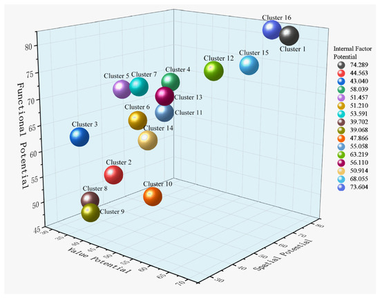
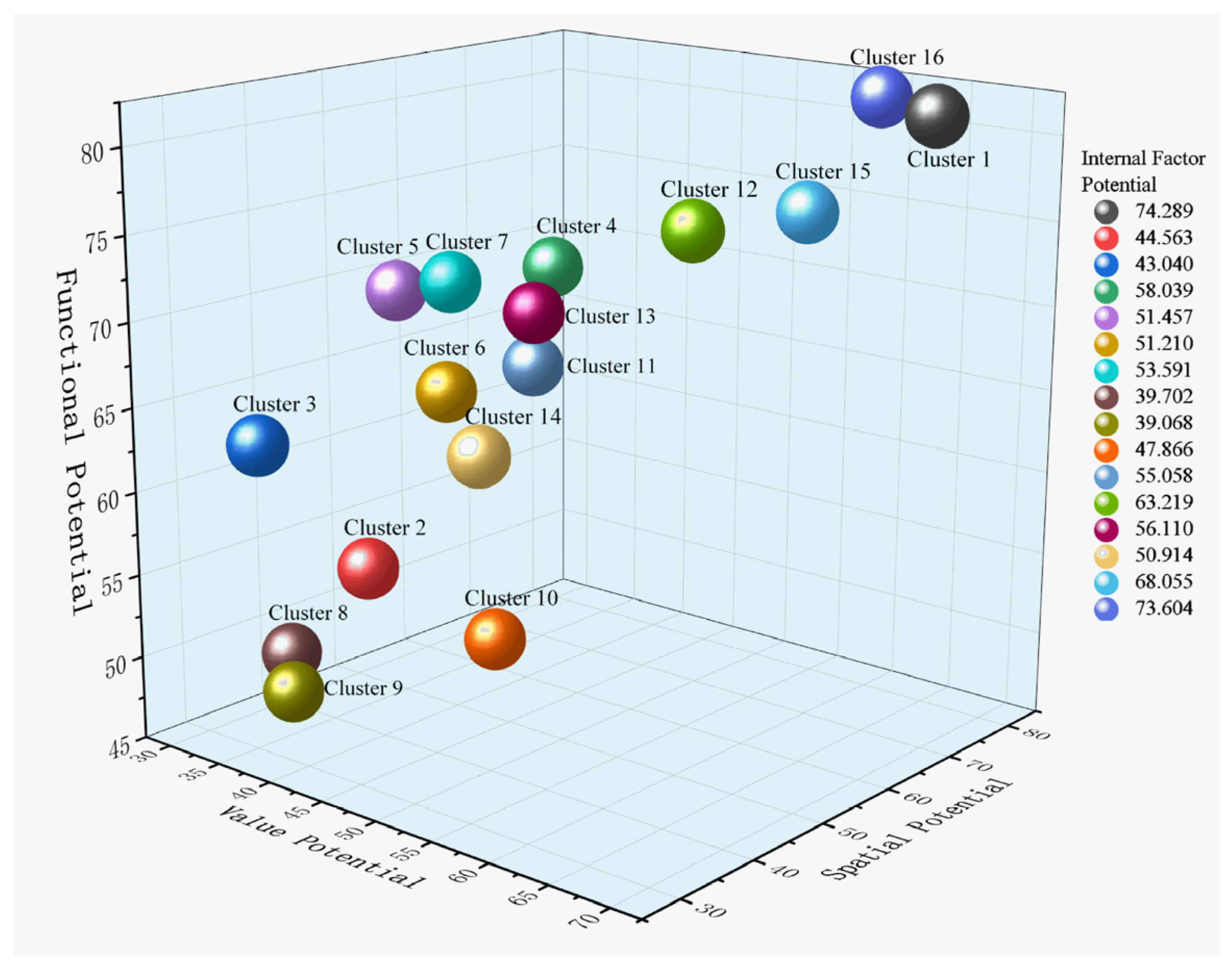
By integrating the value, spatial, and functional potentials of all traditional village clusters within Henan Province, the overall potential assessment of the internal aspects of traditional villages was achieved (Table 10). Based on these results, we applied them to Origin 2024 software to produce 3D spatial visualizations, which showed the spatial features of the cluster distribution (Figure 6):
Table 10.
Comprehensive evaluation results of internal elements of traditional village clusters in Henan Province.
Figure 6.
Three-Dimensional Visualization of Internal Factor Evaluation.
- Henan Province has five traditional village clusters with average internal factor potential: Cluster 9, Cluster 8, Cluster 3, Cluster 2, and Cluster 10.
- Eleven clusters have high internal factor potential, ranked from low to high based on the overall potential scores: Cluster 14, Cluster 6, Cluster 5, Cluster 7, Cluster 11, Cluster 13, Cluster 4, Cluster 12, Cluster 15, Cluster 16, and Cluster 1.
5.3. Cluster Classification and Resource Organization
Based on the evaluation results of the development potential of traditional village clusters in Henan Province, five distinct cluster types have been identified: clusters with extremely high external factor potential and high internal factor potential; clusters with high external factor potential and high internal factor potential; clusters with high external factor potential and low internal factor potential; clusters with low external factor potential and high internal factor potential; and clusters with low external factor potential and low internal factor potential. By integrating the potential evaluation results with an analysis of unique resources, these clusters are grouped into five development types: Diversified Development, Eco-cultural Tourism, Culturally led, Landscape Enhancement, and Infrastructure Improvement (Table 11).
Table 11.
Classification and Resource Inventory of Traditional Village Clusters in Henan Province.
6. Discussion
Henan has a large territory with traditional village clusters endowed with unique resources. The clusters are diverse: some contain intangible cultural heritage and human traditions, whereas others feature unique natural ecosystems and landforms. Some are also of high endogenous capacity without external support. The persistence of agricultural society and the existence of diverse topographies mean that rural planning, rather than general planning, will have to be tailored to meet particular needs. It can only be prevented by scientifically grounded, focused strategies that align with the specific features of each cluster to avoid the misallocation of resources and homogenized development [37]. This course of action will aid in matching resources to advantage, highlight unique features, and deliver differentiated, sustainable development to the traditional village clusters of Henan.
6.1. Strategies for the Clustered Development of Traditional Villages in Henan Province
The discovery of traditional village clusters, as well as the evaluation of their developmental potential, provides the basis for the development of strategies. The paper categorizes the traditional villages in Henan Province into 16 clusters, which are differentiated into five typologies of development based on resource analysis and evaluation.
6.1.1. Diversified Development Strategy
Clusters 5, 12, and 13 are categorized under the Diversified Development Type, where the strategy focuses on cultural tourism development through spatial optimization and enhancement. Such clusters use ecological resources to develop eco-tourism initiatives, e.g., nature sightseeing and ecological activities. They also apply positive humanistic resources to learn about tangible and intangible cultural heritage, to establish cultural brands, and to seek various cultural tourism routes. The spatial potential of these clusters is high, which can be used to approximate the utilization of traditional buildings, thereby increasing their functionality. They also exploit functional potential to rationalize traditional structures, thereby forming specialized industries such as handicrafts and cultural-creative industries. This heuristic maximization encourages various paths of development.
6.1.2. Eco-Cultural Tourism Strategy
Clusters 4, 6, 7, and 11 are under the Eco-cultural Tourism Type, where a strategy is applied to ecological cultural tourism and multifunctional development. These clusters are endowed with ecological, spatial, and functional potential. They exploit high-potential ecological resources, such as afforestation and optimal channeling of rivers and wetlands, which enhance environmental quality. Eco-tourism is based on establishing a distinct brand, with the aim of eco-tourism projects, such as natural landscape tours, ecological hiking, and rural camping, to promote economic growth and focus on eco-agriculture. These agglomerations merge experiences to create more attractive programs, complemented by cultural innovation and festival experiences. Infrastructure, such as transport and accommodation, is also enhanced to facilitate general growth. Cooperation with the local surroundings is promoted to differentiate functions and create regional tourism networks.
6.1.3. Culturally Led Strategy
Clusters 3 and 10 are classified as Culturally led Type, a strategy that aims to revitalize intangible cultural heritage and improve business models. The two clusters have significant potential in human resources, and Cluster 10 also has significant potential in natural resources. Such characteristics provide a chance to learn more about the culture, ancient traditions, and the introduction of intangible cultural heritage in the villages. For example, folk culture exhibition halls may be set up to demonstrate village culture, traditional festivals and folk performances may be hosted to provide visitors with a cultural experience, and artisans may establish intangible cultural heritage ateliers to guide visitors in cultural experience and preservation.
6.1.4. Landscape Enhancement Strategy
Clusters 1, 14, 15, and 16 are under Landscape Enhancement Types, whose strategy is to enhance landscape development together with the growth of local industries. These clusters possess significant development potential in their internal elements, but their ecological resource conditions are moderate, while their cultural resource conditions and supporting conditions are low. This strategy will aim to maximize the value, space, as well as the functional capacity of these internal factors. The village environment and its historical buildings must be maintained to emphasize their historical and cultural significance. The rational layout of the buildings’ functions, high spatial potential, the inclusion of public areas, and cultural showcases can improve visitors’ experiences. Specialty agricultural processing and other handicraft and industrial production can serve as a functional revitalization and industry cultivation, wherein the fulfillment of specialization will enhance economic income through these types of production in tandem with the inner potential.
6.1.5. Infrastructure Improvement Strategy
The clusters can be included as Infrastructure Improvement Types, such as Clusters 2, 8, and 9, in which a strategy of combining ecological experiences with infrastructure development is embraced. These clusters exhibit low development potential in terms of humanistic resources and supporting conditions, but possess favorable ecological resource conditions. The development should capitalize on these strengths and explore leveraging the positive ecological environment to develop eco-tourism products for tourists and immigrants through the villages, such as natural landscape tourism and eco-agricultural experiences, to supplement the villages’ ecological environments. Simultaneously, infrastructure should be built, such as transportation, water and electricity supply, and communications, and these should take priority. Parking and visitor service centers are the facilities to be constructed to increase capacity. Also, there should be an attempt to secure government funding and policy backing for the preservation and development of traditional villages.
6.2. Research Contributions, Research Limitations, and Future Work
This paper demonstrates consistency with existing studies on traditional village conservation, using a similar reasoning structure. Both methods emphasize settlement delineation based on spatial aggregation and cultural relevance, as well as multi-dimensional assessment procedures that consider ecological, cultural, and social aspects [38,39]. The discrepancy between previous research is that it is much closer to the geographical features of Henan’s traditional villages. The available literature is mostly aimed at searching for clusters based on a single dimension of space or culture, e.g., GIS kernel density and intangible cultural heritage typology clustering. It also tends to use one of the few numerical methods, such as AHP and fuzzy mathematics, to estimate potential. Nevertheless, the distinctive features of Henan, such as its persistence in agricultural culture, heterogeneous topography, and hybrid heritage, are not taken into consideration by those approaches. The paper presents a high level of connectivity among resources, including cultural landscapes, ecological landscapes, and cultural heritage. It constructs a three-dimensional identification system that integrates spatial, cultural, and resource factors. The 16 clusters created represent a pattern described as one pole, three cores, and four belts, reflecting Henan’s geographical and cultural uniqueness. The evaluation methodology is based on GIS technology for external factor evaluation and cloud-based analysis of internal factors. This solution addresses the shortcomings of single-method and single-dimensional tests and aligns more closely with the actual situation in rural Henan, where villages still have well-preserved buildings but lack restoration efforts.
The limitations of this research are threefold. First, it contains only 275 nationally determined traditional villages, leaving out 1018 provincial-level villages, which might not reflect the clustering properties of regions such as Eastern Henan. Second, the K-means clustering algorithm applied to create the initial K = 15 clusters was subjective. Even though it is still verified using SSE and ANOVA, more scientific techniques are required to overcome the limitations of subjectivity. Third, the analysis is based on cross-sectional data from 2024–2025, which considers more dynamic variables, such as changes in policy and climate conditions, so it is not as timely. Future improvements can be regulated at three levels: First, expand the research to other provinces with traditional village statistics and investigate the possibilities of cross-regional cooperation. Second, the development potential of the villages can be simulated by applying digital models and conditions such as ecological or cultural tourism priorities [40]. Third, the evaluation indicator system should be refined by adding multiple levels and improving the methodology’s overall universality.
7. Conclusions
The paper concerns the primary problems of blindness and fragmentation in the preservation and development of traditional villages, based on 275 national-level traditional villages in Henan Province. It suggests a holistic, cluster-based approach to preservation and development, incorporating spatial analysis and examination, quantitative analysis, and strategy development to offer a calculated solution: identification, assessment, and strategy.
The major research conclusions may be summarized as follows: First, a three-dimensional identification system was developed, integrating principles of spatial connectivity, historical–cultural relevance, and unique resource association. The traditional villages in Henan were clustered using the K-means and geographic optimization systems to create a spatial framework of one pole, three cores, and four belts. This organization aligns with Henan’s geographical features, with mountains in the West and plains in the East. Second, a dual-dimensional system for evaluating potential was created to assess both internal and external factors. Spatial analysis of GIS suitability was applied as a measure of external factors, e.g., ecological and cultural resources, and of support conditions. Cloud models analyzed the ambiguity in internal elements, which were appraised along three dimensions: value, spatial distribution, and functionality. The potential was then categorized into five levels. Third, differentiated strategies were suggested based on the internal-external potential matrix, which identified five alternative resource endowments to align with the relevant development paths.
The theoretical relevance of the present study lies in its attempt to overcome the limitations of existing research, which tends to focus on a single area and overlooks system integration. It is useful because it provides standardized instruments for nationwide application of the Demonstration across concentric and continuous conservation zones, including the implementation of K-means clustering and a dual-facet evaluation to rank these zones. This would lead to local, differentiated assessment measures and cross-departmental information exchange among the natural resources, cultural tourism, and housing authorities. It addresses the dilemma between planning and implementation in the conservation process and provides technical assistance for policy implementation. The main concept of multi-dimensional identification, dual-dimensional evaluation, and differentiated strategies can be generalized to include the preservation of traditional villages in the Central Plains cultural sphere, i.e., Shanxi, Hebei, Shandong, and Henan, as well as other areas with similar geographical conditions, showing strong prospects for large-scale applicability.
Author Contributions
Conceptualization, H.W.; methodology Y.H. and Z.Y.; software, H.Z., Z.Y. and L.X.; validation, H.W. and H.J.; formal analysis, B.L.; investigation, Z.Y. and L.X.; data curation, Y.H. and H.Z.; writing—original draft preparation, Y.H.; writing—review and editing, H.W., H.J. and E.M.; visualization, Y.H., H.Z. and L.X.; supervision, H.W.; project administration, B.L.; funding acquisition, B.L. All authors have read and agreed to the published version of the manuscript.
Funding
This research was funded by the Cultural Research Special Program of the Henan Xingwenhua Project (Grant No. 2024XWH110) and the Henan Provincial Key Research and Development Special Project (Grant No. 241111211500). The APC was funded by the Henan Provincial Key Research and Development Special Project (Grant No. 241111211500).
Institutional Review Board Statement
According to the research management regulations of Henan Agricultural University, non-interventional anonymous questionnaire surveys and expert evaluation studies for academic purposes do not require formal ethical review. The study was conducted in accordance with the Declaration of Helsinki.
Informed Consent Statement
Written informed consent was obtained from all questionnaire respondents and seven invited experts in urban-rural planning and architecture before the field survey. All personal identifiable information was eliminated to protect participant privacy.
Data Availability Statement
All data used in this study are detailed in the Data Sources section of the submitted manuscript and are openly available for download.
Acknowledgments
The authors sincerely thank the Zhengzhou Key Laboratory of Digital Protection of Historical and Cultural Heritage for providing research facilities and technical support during this study.
Conflicts of Interest
The authors declare no conflicts of interest. The funders had no role in the design of the study; in the collection, analyses, or interpretation of data; in the writing of the manuscript; or in the decision to publish the results.
Abbreviations
The following abbreviations are used in this manuscript:
| AHP | Analytic Hierarchy Process |
| ANOVA | Analysis of Variance |
| CAS | Chinese Academy of Sciences |
| Cv | Coefficient of Variation |
| DEM | Digital Elevation Model |
| ICH | Intangible Cultural Heritage |
| IDW | Inverse Distance Weighted |
| NDVI | Normalized Difference Vegetation Index |
| POI | Point of Interest |
| SSE | Sum of Squared Errors |
References
- Guo, Z.; Sun, L. The planning, development and management of tourism: The case of Dangjia, an ancient village in China. Tour. Manag. 2016, 56, 52–62. [Google Scholar] [CrossRef] [Scilit]
- Zhao, X.; Xue, P.; Wang, F.; Qin, Y.; Duan, X.; Yang, Z. How to become one? The modern bond of traditional villages in centralized contiguous protection and utilization areas in China. Habitat Int. 2024, 145, 103018. [Google Scholar] [CrossRef] [Scilit]
- Lin, M.; Jian, J.; Yu, H.; Zeng, Y.; Lin, M. Research on the Spatial Pattern and Influence Mechanism of Industrial Transformation and Development of Traditional Villages. Sustainability 2021, 13, 8898. [Google Scholar] [CrossRef] [Scilit]
- Fan, J.; Zheng, B.; Yuan, H.; Zhang, B.; Zhang, P. Spatial Connectivity and Development Potential of Traditional Villages in Clustered Areas: A Case Study of Qiandongnan Prefecture. Land 2025, 14, 1929. [Google Scholar] [CrossRef] [Scilit]
- Zhang, D.; Zhang, W.; Chen, D. Analysis and exploration of the concept of traditional settlement protection and development cluster mode in the new period. Urban Dev. Stud. 2022, 29, 16–21+39. (In Chinese) [Google Scholar]
- Bi, S.; Du, J.; Tian, Z.; Zhang, Y. Investigating the spatial distribution mechanisms of traditional villages from the human geography region: A case study of Jiangnan, China. Ecol. Inform. 2024, 81, 102649. [Google Scholar] [CrossRef] [Scilit]
- Liu, Y.; Liu, L.; Xu, R.; Yi, X.; Qiu, H. Spatial distribution of toponyms and formation mechanism in traditional villages in Western Hunan, China. Herit. Sci. 2024, 12, 171. [Google Scholar] [CrossRef] [Scilit]
- Li, Y.; Fan, W.; Yuan, X.; Li, J. Spatial distribution characteristics and influencing factors of traditional villages based on geodetector: Jiarong Tibetan in Western Sichuan, China. Sci. Rep. 2024, 14, 11700. [Google Scholar] [CrossRef] [Scilit]
- Lin, Z.; Liang, Y.; Liu, X. Study on spatial form evolution of traditional villages in Jiuguan under the influence of historic transportation network. Herit. Sci. 2024, 12, 29. [Google Scholar] [CrossRef] [Scilit]
- Su, X.; Zhou, H.; Guo, Y.; Zhu, Y. Multi-Dimensional Influencing Factors of Spatial Evolution of Traditional Villages in Guizhou Province of China and Their Conservation Significance. Buildings 2024, 14, 3088. [Google Scholar] [CrossRef] [Scilit]
- Guo, Y.; Rao, J.; Huang, J.; Zhu, Y. Spatial and Temporal Evolution and Conservation Significance of Traditional Villages in the Yangtze River Basin, China. Buildings 2024, 14, 3249. [Google Scholar] [CrossRef] [Scilit]
- Li, Q.; Lv, S.; Chen, Z.; Cui, J.; Li, W.; Liu, Y. Traditional Villages’ Cultural Tourism Spatial Quality Evaluation. Sustainability 2024, 16, 7752. [Google Scholar] [CrossRef] [Scilit]
- Liu, S.; Zhu, Z.; Gao, Y.; Wang, S. Assessing the dynamic vitality of public spaces in tourism-oriented traditional villages: A collaborative active perception method. Herit. Sci. 2024, 12, 346. [Google Scholar] [CrossRef] [Scilit]
- Kang, N.; Liu, C. Assessment of visual quality and social perception of cultural landscapes: Application to Anyi traditional villages, China. Herit. Sci. 2024, 12, 235. [Google Scholar] [CrossRef] [Scilit]
- Li, G.; Chen, B.; Zhu, J.; Sun, L. Traditional Village research based on culture-landscape genes: A Case of Tujia traditional villages in Shizhu, Chongqing, China. J. Asian Archit. Build. Eng. 2024, 23, 325–343. [Google Scholar]
- Yuan, L.; Xu, L.; Zhang, Z.; Xu, Y. Traditional village clustered protection and utilization methods based on network science. npj Herit. Sci. 2025, 13, 140. [Google Scholar] [CrossRef] [Scilit]
- Fan, L.; Zhang, D.; Li, X.; Shi, Y. Research on the Coordinated Development of Traditional Village Protection and Utilization from a Centralized and Contiguous Perspective: Taking Mentougouin Beijing as an Example. Chin. Landsc. Archit. 2025, 41, 79–86. (In Chinese) [Google Scholar]
- Nie, Z.; Dong, T.; Pan, W. Spatial differentiation and geographical similarity of traditional villages—Take the Yellow River Basin and the Yangtze River Basin as examples. PLoS ONE 2024, 19, e0295854. [Google Scholar] [PubMed]
- Zhang, M.; Shen, C.; Gu, W.; Chen, Q. Identification of Traditional Village Aggregation Areas from the Perspective of Historic Layering: Evidence from Hilly Regions in Zhejiang Province, China. Land 2023, 12, 2088. [Google Scholar] [CrossRef] [Scilit]
- Shen, C.; Lu, Q.; Chen, Q.; Zhang, M. Spatial identification and planning strategy of traditional village cluster areas: A case study of mountainous and hilly regions in Zhejiang province. Geogr. Res. 2024, 43, 446–461. (In Chinese) [Google Scholar]
- Dai, Y.; Zhong, J.; Wang, R.; Ping, N.; Chen, Z. Research on Cluster Zoning and Preservation of Historical Village and Town Clusters from Regional Perspective: A Case Study of the Underdeveloped Areas of Chongqing. Mod. Urban Res. 2024, 8, 41–48. (In Chinese) [Google Scholar]
- Kopczewska, K. Spatial machine learning: New opportunities for regional science. Ann. Reg. Sci. 2022, 68, 713–755. [Google Scholar]
- Zhang, Y.; Li, J. Constructing a “Clustered-Boundary-Cellular” Model: Spatial Differentiation and Sustainable Governance of Traditional Villages in Multi-Ethnic China. Sustainability 2025, 17, 9268. [Google Scholar]
- Wang, X.; Zhu, X.; Tang, P. Characterization of the Chinese traditional villages based on the morphological clustering and knowledge graph. In Proceedings of the Conference on Computer Aided Architectural Design Research in Asia (CAADRIA), Singapore, 20–26 April 2024. [Google Scholar]
- Xia, J.; Deng, M.; Zhu, L. Assessing the location potential for tourism development of traditional villages in Sichuan province, China. Sci. Rep. 2025, 15, 28239. [Google Scholar] [CrossRef] [Scilit] [PubMed]
- Tang, C.; Yang, Y.; Liu, Y.; Xiao, X. Comprehensive evaluation of the cultural inheritance level of tourism-oriented traditional villages: The example of Beijing. Tour. Manag. Perspect. 2023, 48, 101166. [Google Scholar] [CrossRef] [Scilit]
- Zu, X.; Liu, P.; Gao, C.; Hou, R.; Huang, Z.; Ao, Y.; Wang, Y. Traditional village preservation status evaluation and optimization based on YOLOv10 and random forest model—Take the Tibetan-Qiang region in northwest Sichuan as an example. Front. Archit. Res. 2026, 15, 353–369. [Google Scholar]
- Xing, Y.; Leng, J.; Zhou, H. Cognitive preferences for architectural renovation strategies in traditional villages combining subjective evaluation and eye tracking. Front. Archit. Res. 2025, 14, 1017–1034. [Google Scholar] [CrossRef] [Scilit]
- Zhang, Q.; Cao, Z.; Liu, Y. Assessing rural revitalization potential through rural transformation degree and sustainability: A quantitative study of 460 case villages in Lingbao, China. Habitat Int. 2024, 153, 103194. [Google Scholar] [CrossRef] [Scilit]
- Dempsey, N.; Bramley, G.; Power, S.; Brown, C. The social dimension of sustainable development: Defining urban social sustainability. Sustain. Dev. 2011, 19, 289–300. [Google Scholar] [CrossRef] [Scilit]
- Ma, H.; Tong, Y. Spatial differentiation of traditional villages using ArcGIS and GeoDa: A case study of Southwest China. Ecol. Inform. 2022, 68, 101416. [Google Scholar]
- Liu, S.; Ge, J.; Bai, M.; Yao, M.; Zhu, Z. Uncovering the factors influencing the vitality of traditional villages using POI (point of interest) data: A study of 148 villages in Lishui, China. Herit. Sci. 2023, 11, 123. [Google Scholar] [CrossRef] [Scilit]
- Song, J.; Zhu, Y.; Chu, X.; Yang, X. Research on the Vitality of Public Spaces in Tourist Villages through Social Network Analysis: A Case Study of Mochou Village in Hubei, China. Land 2024, 13, 359. [Google Scholar] [CrossRef] [Scilit]
- Xiao, J.; Qiao, J.; Han, D.; Ma, Y.; Zhu, Q.; Wang, W. Spatial distribution and transformation mechanism of specialized villages in typical agricultural areas: Case study of Henan province, China. Habitat Int. 2024, 146, 103034. [Google Scholar] [CrossRef] [Scilit]
- Hong, T.; Lai, Z.; Huang, X.; Zheng, Y. Identification and Protection of Traditional Village Cluster Based on Clustering Analysis: A Case Study of Zhangzhou City. Landsc. Archit. 2023, 30, 121–129. (In Chinese) [Google Scholar]
- Chen, W.; Yang, L.; Wu, J.; Wu, J.; Wang, G.; Bian, J.; Zeng, J.; Liu, Z. Spatio-temporal characteristics and influencing factors of traditional villages in the Yangtze River Basin: A Geodetector model. Herit. Sci. 2023, 11, 111. [Google Scholar] [CrossRef] [Scilit]
- Wang, W.; Wang, Y.; Wang, H.; Liu, Y.; Yang, Q. Rural spatial planning strengthens rural resilience and sustains development in China. Sustain. Futures 2025, 10, 101123. [Google Scholar] [CrossRef] [Scilit]
- Yan, H.; Dong, R.; He, Y.; Qi, J.; Li, L. Spatial Agglomeration Differences of Amenities and Causes in Traditional Villages from the Perspective of Tourist Perception. Sustainability 2025, 17, 4475. [Google Scholar] [CrossRef] [Scilit]
- Wang, H.; Wang, Y.; Ren, Z.; Wu, C.; Song, W. Cluster-Based Protection Mechanisms for Coastal Traditional Villages: A Complex Network Analysis Approach with a Case Study of Rongcheng, Shandong Province (Part 1). Buildings 2025, 15, 784. [Google Scholar] [CrossRef] [Scilit]
- Long, T.; Ișık, C.; Yan, J.; Zhong, Q. Promoting the sustainable development of traditional villages: Exploring the comprehensive assessment, spatial and temporal evolution, and internal and external impacts of traditional village human settlements in Hunan province. Heliyon 2024, 10, e32439. [Google Scholar] [CrossRef] [Scilit] [PubMed]

Disclaimer/Publisher’s Note: The statements, opinions and data contained in all publications are solely those of the individual author(s) and contributor(s) and not of MDPI and/or the editor(s). MDPI and/or the editor(s) disclaim responsibility for any injury to people or property resulting from any ideas, methods, instructions or products referred to in the content. |
© 2026 by the authors. Licensee MDPI, Basel, Switzerland. This article is an open access article distributed under the terms and conditions of the Creative Commons Attribution (CC BY) license.