Identifying Clusters + Evaluating Development Potential: An Integrated Framework for Traditional Village Clustered Protection and Utilization

 , ,
, ,
Abstract
1. Introduction
2. Research Area and Data Sources
2.1. Research Area
2.2. Data Sources and Processing
3. Cluster Identification
3.1. Construction of Clustering Indicator Systems
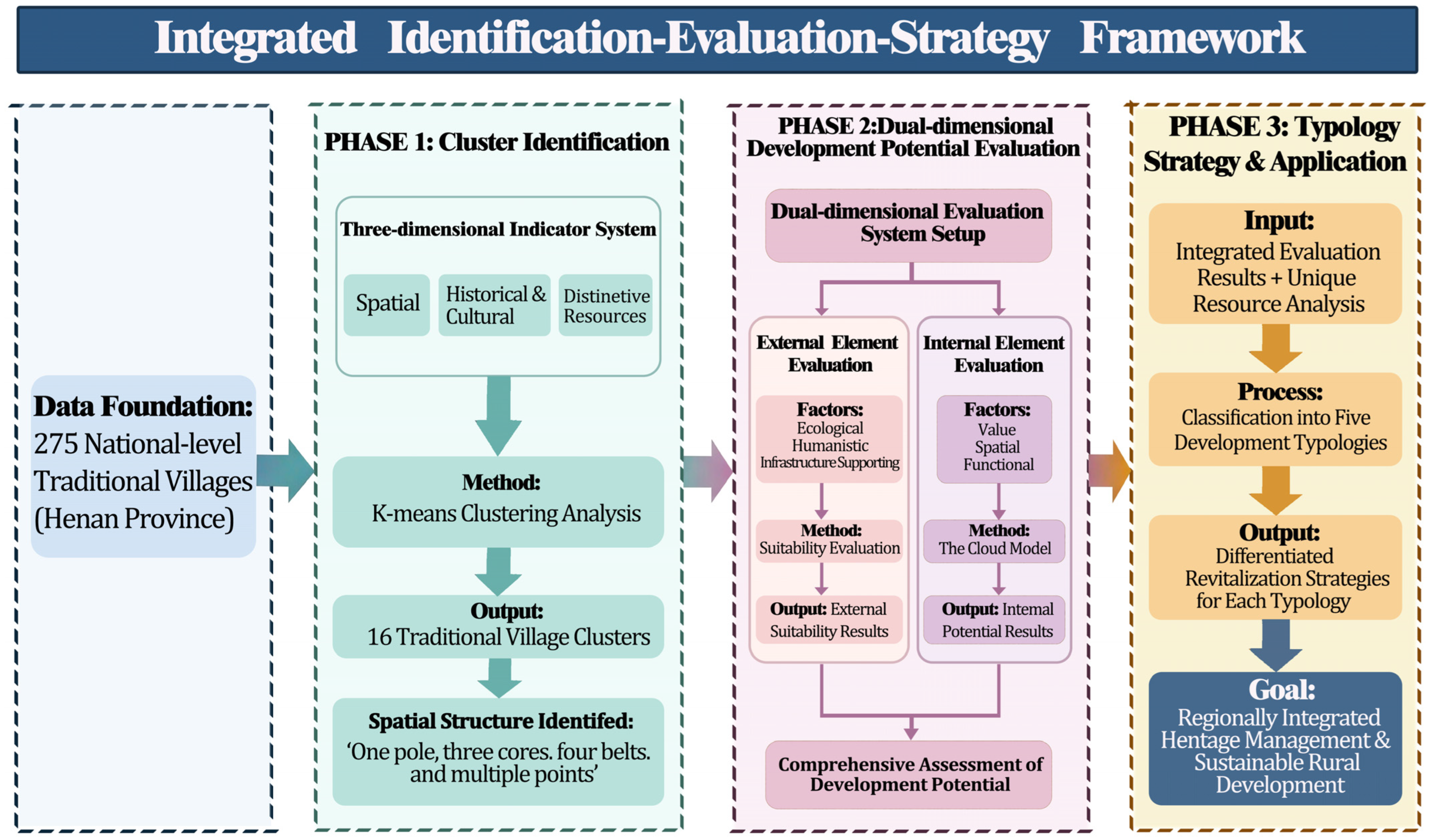
3.2. Technical Route of Cluster Identification
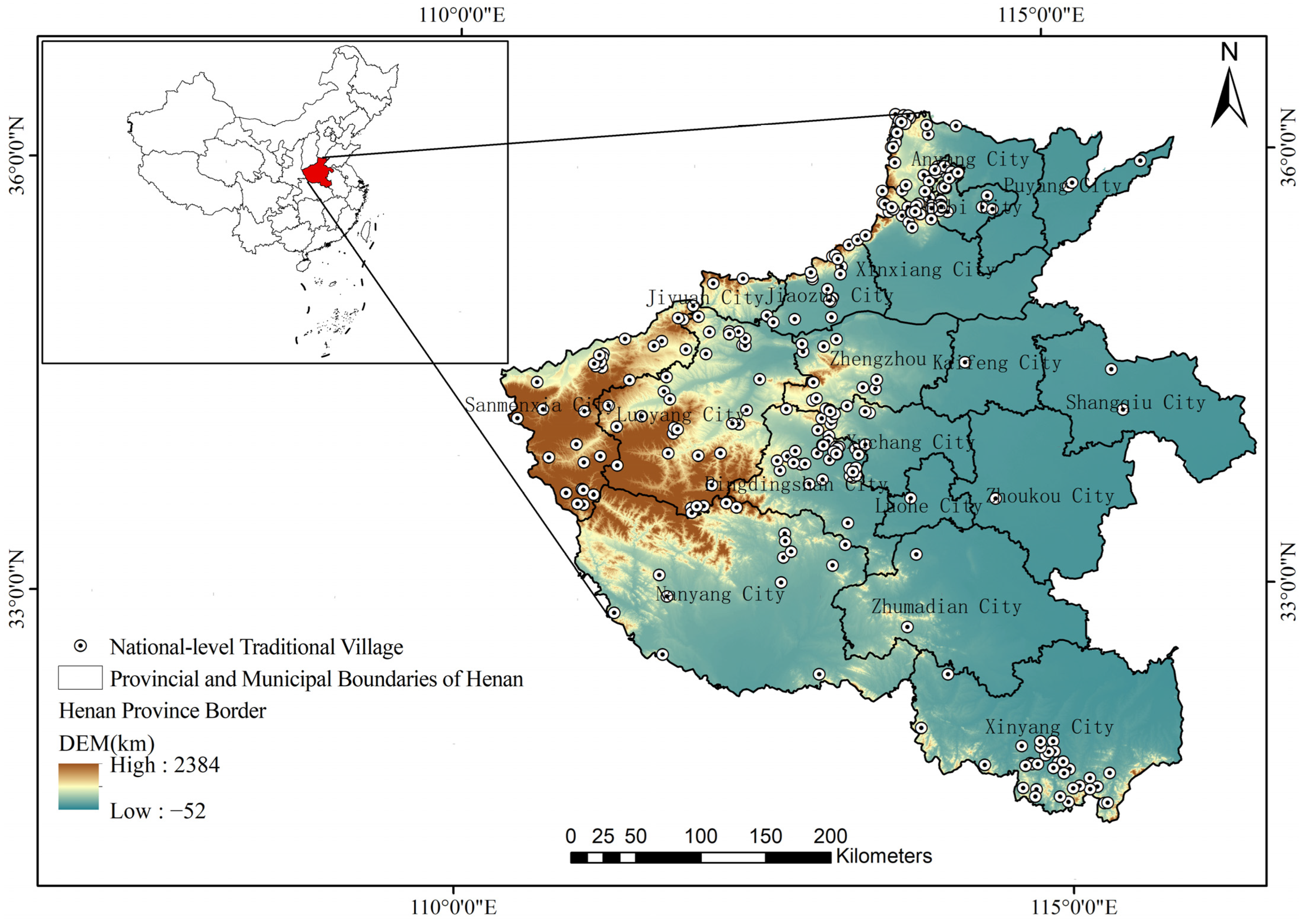
- Acquisition of basic spatial data. The precise geographic coordinates of 275 traditional villages in the study area are extracted via Google Earth Pro. The coordinate data are imported into the ArcGIS 10.7 platform to generate a vector layer of village spatial distribution, which provides basic fundamental data for subsequent spatial correlation analysis.
- Sorting and assignment of multi-dimensional attribute data. Based on local chronicles, genealogy documents, publicly released government data at all levels, and field investigations, this study systematically collects historical and cultural data of traditional villages, including historical evolution and village construction context, as well as characteristic resource data covering village cultural landscapes, ecological landscapes, and cultural heritage. All data are uniformly converted into standard vector attribute data and assigned to corresponding village points.
- Visual characterization of multi-dimensional correlation features. Based on the ArcGIS 10.7 platform, visualized expression is conducted on three types of data, namely spatial distribution, historical culture, and characteristic resources. It intuitively reveals the spatial correlation, cultural context correlation, and resource correlation characteristics of traditional villages in Henan Province, providing feature support for cluster identification and judgment.
- Primary clustering and grouping. With the multi-dimensional resource correlation features as input parameters, the K-means clustering algorithm embedded in SPSS 22.0 software is adopted to group sample villages. Villages with highly similar spatial, cultural and resource attributes are classified into the same cluster unit.
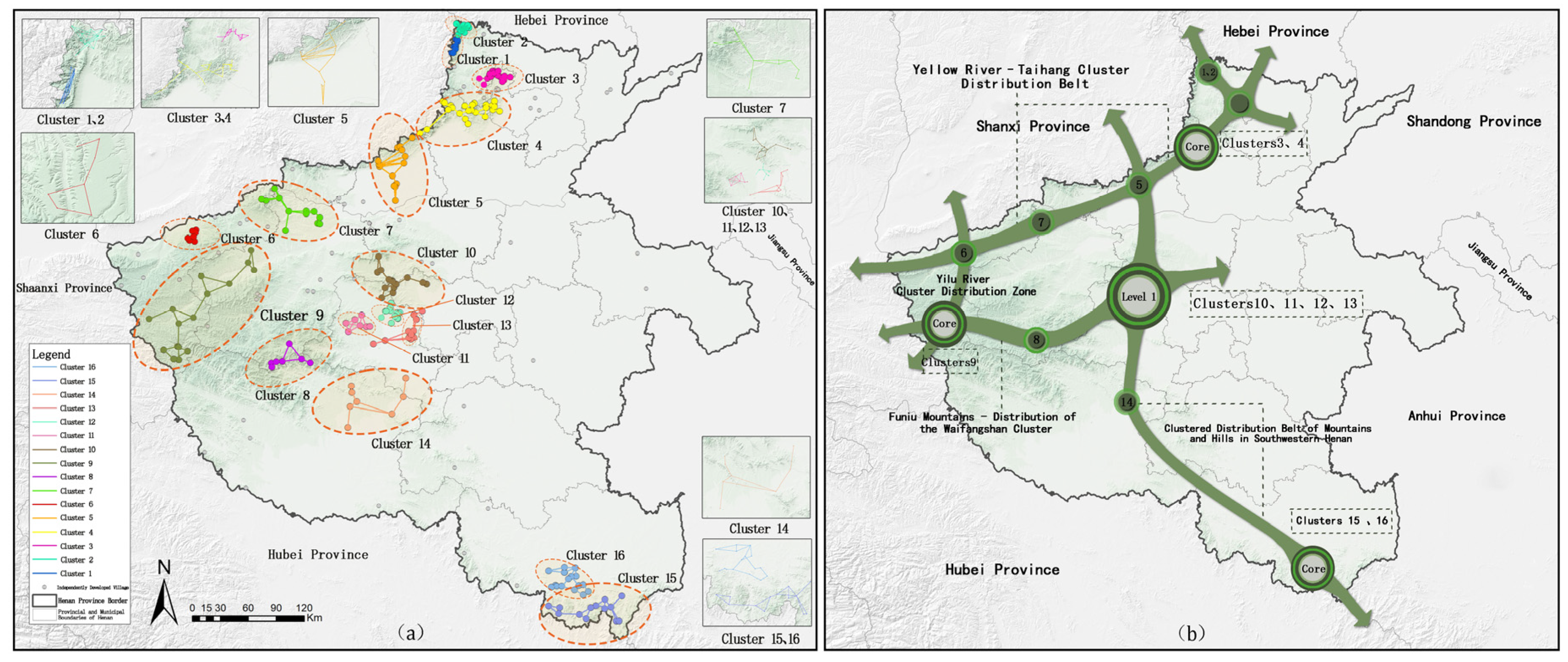
- Secondary aggregation optimization and cluster determination. On the basis of primary clustering results, secondary aggregation classification and clustering pruning optimization are carried out by comprehensively considering village spatial distance, resource proximity, traffic correlation and other factors. Finally, the cluster system of traditional villages in Henan Province is established, and the visual output of the cluster spatial pattern is realized.
3.3. K-Means Clustering Analysis
- Setting and Iterative Testing of the K-value: The K-value range was set between 10 and 20 based on traditional village locations. Multiple cycles of iterative testing were conducted using SPSS K-means clustering, with each iteration recorded and the within-cluster sum of squares (SSE) calculated. A lower SSE indicated higher within-cluster similarity and improved clustering performance (Table 4).
- Optimal K Value: When K = 15, the sample distribution per cluster stabilized and SSE reached its minimum, reflecting the highest intra-cluster similarity and greatest inter-cluster differences. Thus, K = 15 was selected as the optimal solution.
- Validity of Clustering Results: ANOVA in SPSS showed that, except for a few indicators (e.g., residential layout), the remaining 40 indicators had p-values < 0.001, indicating significant differences across clusters and confirming that the K = 15 solution is scientifically valid for differentiating traditional villages in Henan Province (Table 5).
4. Development Potential Evaluation
4.1. Evaluation System Construction
4.2. Suitability Evaluation Process
4.2.1. Establishing a Unified Evaluation Framework
4.2.2. Single-Factor Analysis and Standardization
- Ecological Resource Indicators:Based on expert judgment and the GIS natural breaks classification method, the indicators are divided into five grades. For instance, areas with an elevation above 1000 m are classified as “suitable”, while those below 100 m are “unsuitable”, with standardized scores ranging from 1 to 5 assigned to each grade, respectively.
- Humanistic Resource Indicators:For point and area resources (such as scenic spots and cultural heritage sites), suitability is assessed based on proximity. The Euclidean distance from each grid cell to the resource is calculated using ArcGIS tools, then reclassified into five levels—shorter distances receive higher standardized scores (1 to 5).
- Supporting Condition Indicators:Facility data (e.g., POI counts per grid cell), road density, population, and GDP are spatially allocated and analyzed. These measures are also categorized and standardized on a 1 to 5 scale according to their relative magnitude.
4.2.3. Integrated Potential Calculation and Grading
4.3. Cloud Model Evaluation Method
4.3.1. Establishment of the Evaluation Model
4.3.2. Building a Standard Cloud Model
4.3.3. Calculation of Comprehensive Evaluation Parameters
4.3.4. Cloud Map Generation and Potential Matching
4.4. Coupling of Internal and External Potentials and Cluster Classification
5. Result
5.1. Results of Traditional Village Cluster Identification
5.2. Potential Evaluation Results
5.2.1. Evaluation Results of External Factors
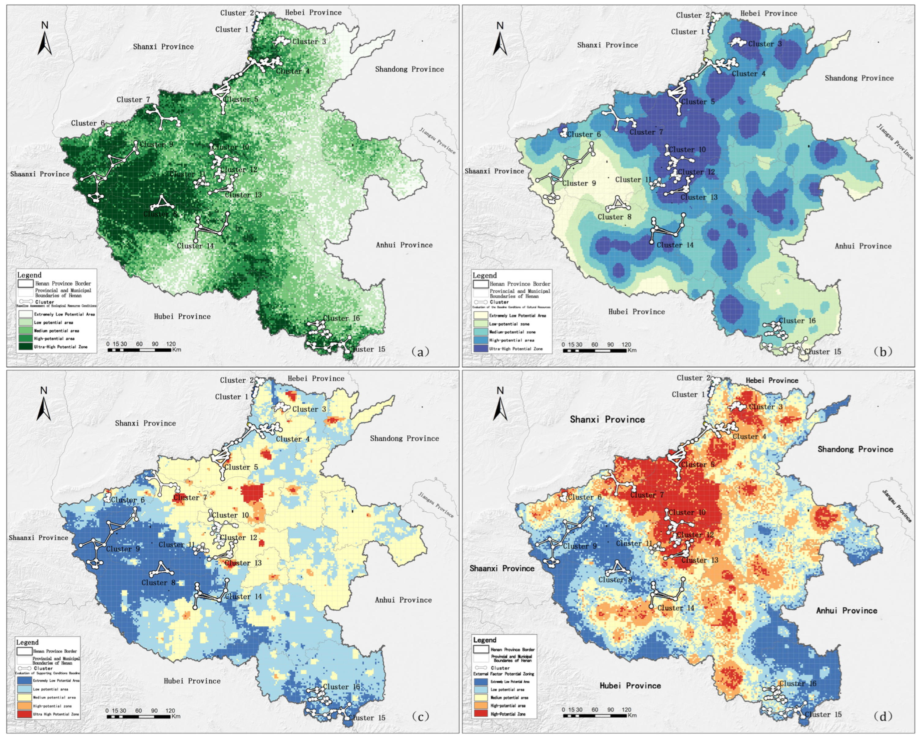
- Five clusters in Henan Province possess extremely high external factor potential, including Cluster 3, Cluster 5, Cluster 10, Cluster 12, and Cluster 13. The potential humanistic resource conditions in these clusters are usually extremely high, whereas the ecological resource conditions are high or medium. Regarding the conditions that need to be supported, Cluster 3 has high potential, while the rest have medium potential. This implies that the strengths of such clusters lie in the abundance of humanistic resources and the favorable ecological conditions. To develop a better supporting environment, development strategies must leverage these benefits.
- Cluster 4, Cluster 6, Cluster 7, and Cluster 11 have high potential for external factors. These high-potential clusters also have great developmental potential in both ecological and humanistic resource conditions, but the supporting conditions are not as robust as those of extremely high-potential clusters. They can make the most of what they have to offer by leveraging favorable resource conditions.
- Cluster 14 has medium potential for external factors.
- The three clusters with low potential, i.e., Cluster 1, Cluster 2, and Cluster 16, have rather favorable ecological resource conditions and are the points of future development.
- The three clusters (Cluster 8, Cluster 9, and Cluster 15) that have extremely low potential indicate rather high ecological resource conditions in comparison to their humanistic resource conditions and supporting conditions. Such clusters should develop using strategies that focus on protecting the ecological environment.
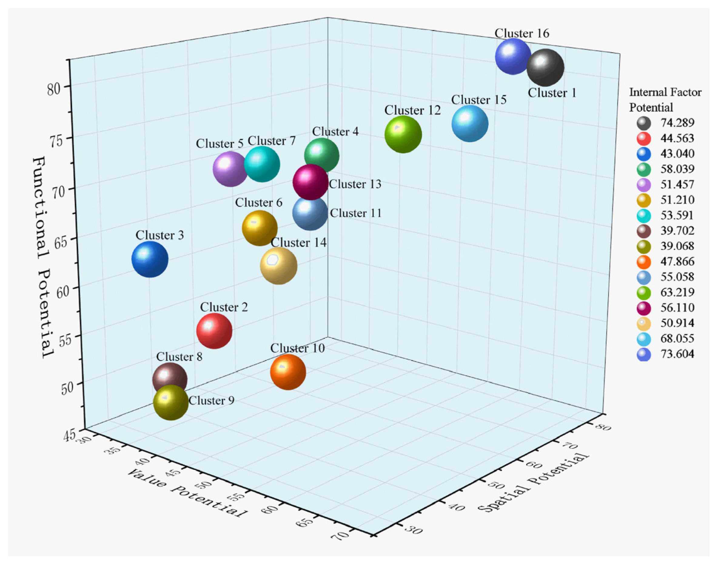
5.2.2. Internal Factor Evaluation Results
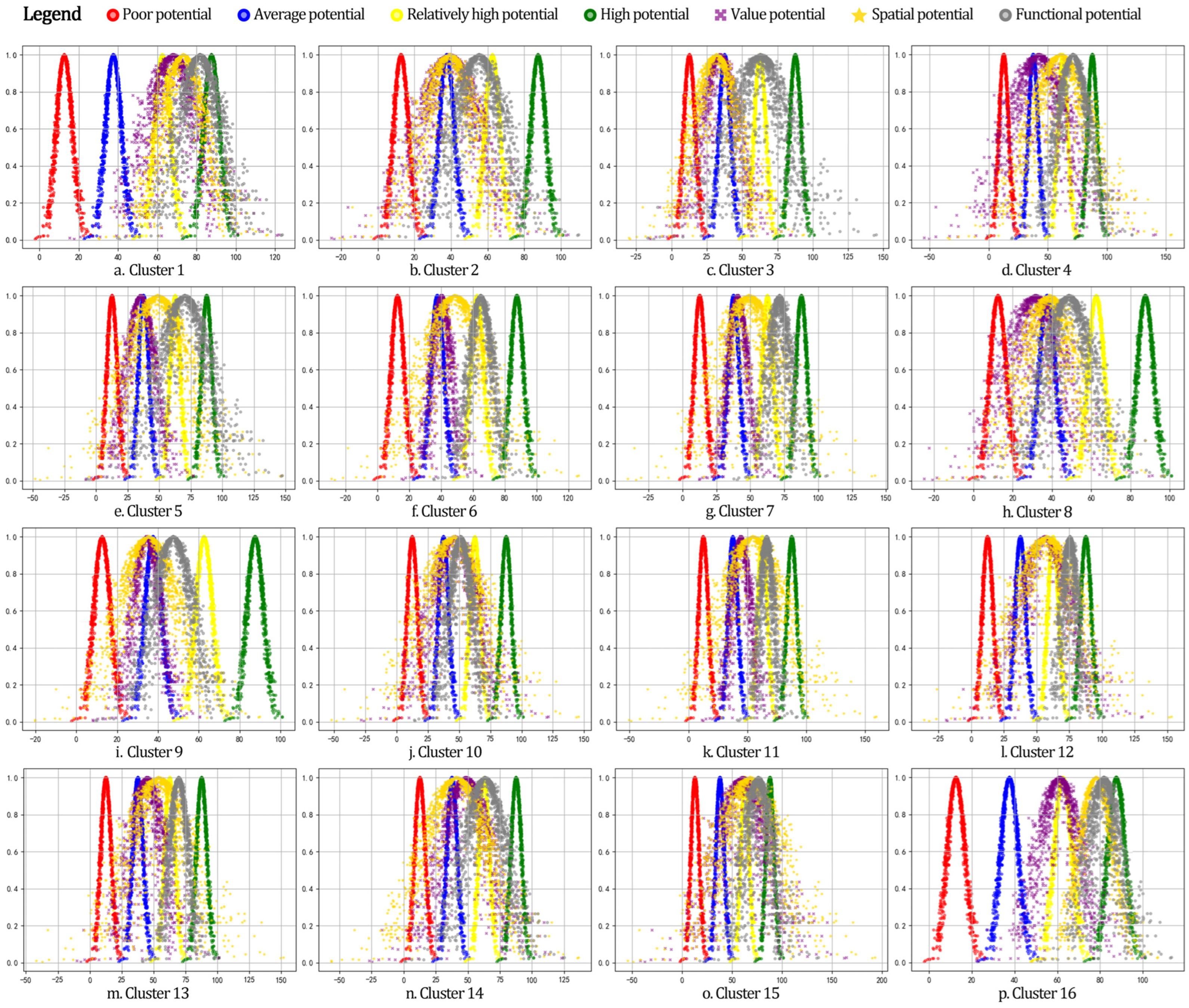
- Value Potential: Twelve clusters have average value potential, while four clusters have high Value Potential. Clusters 12, 15, 16, and 1 have high-value potential.
- Spatial Potential: There are nine clusters with average spatial potential and six clusters with high spatial potential, i.e., Cluster 13, Cluster 11, Cluster 12, Cluster 4, Cluster 15, and Cluster 1. Also, Cluster 16 has very high spatial potential.
- Functional Potential: Two clusters have average functional potential, ten clusters have high functional potential, and four clusters have very high functional potential. Clusters 12, 15, 1, and 6 have very high functional potential.
- Henan Province has five traditional village clusters with average internal factor potential: Cluster 9, Cluster 8, Cluster 3, Cluster 2, and Cluster 10.
- Eleven clusters have high internal factor potential, ranked from low to high based on the overall potential scores: Cluster 14, Cluster 6, Cluster 5, Cluster 7, Cluster 11, Cluster 13, Cluster 4, Cluster 12, Cluster 15, Cluster 16, and Cluster 1.
5.3. Cluster Classification and Resource Organization
6. Discussion
6.1. Strategies for the Clustered Development of Traditional Villages in Henan Province
6.1.1. Diversified Development Strategy
6.1.2. Eco-Cultural Tourism Strategy
6.1.3. Culturally Led Strategy
6.1.4. Landscape Enhancement Strategy
6.1.5. Infrastructure Improvement Strategy
6.2. Research Contributions, Research Limitations, and Future Work
7. Conclusions
Author Contributions
Funding
Institutional Review Board Statement
Informed Consent Statement
Data Availability Statement
Acknowledgments
Conflicts of Interest
Abbreviations
| AHP | Analytic Hierarchy Process |
| ANOVA | Analysis of Variance |
| CAS | Chinese Academy of Sciences |
| Cv | Coefficient of Variation |
| DEM | Digital Elevation Model |
| ICH | Intangible Cultural Heritage |
| IDW | Inverse Distance Weighted |
| NDVI | Normalized Difference Vegetation Index |
| POI | Point of Interest |
| SSE | Sum of Squared Errors |
References
- Guo, Z.; Sun, L. The planning, development and management of tourism: The case of Dangjia, an ancient village in China. Tour. Manag. 2016, 56, 52–62. [Google Scholar] [CrossRef] [Scilit]
- Zhao, X.; Xue, P.; Wang, F.; Qin, Y.; Duan, X.; Yang, Z. How to become one? The modern bond of traditional villages in centralized contiguous protection and utilization areas in China. Habitat Int. 2024, 145, 103018. [Google Scholar] [CrossRef] [Scilit]
- Lin, M.; Jian, J.; Yu, H.; Zeng, Y.; Lin, M. Research on the Spatial Pattern and Influence Mechanism of Industrial Transformation and Development of Traditional Villages. Sustainability 2021, 13, 8898. [Google Scholar] [CrossRef] [Scilit]
- Fan, J.; Zheng, B.; Yuan, H.; Zhang, B.; Zhang, P. Spatial Connectivity and Development Potential of Traditional Villages in Clustered Areas: A Case Study of Qiandongnan Prefecture. Land 2025, 14, 1929. [Google Scholar] [CrossRef] [Scilit]
- Zhang, D.; Zhang, W.; Chen, D. Analysis and exploration of the concept of traditional settlement protection and development cluster mode in the new period. Urban Dev. Stud. 2022, 29, 16–21+39. (In Chinese) [Google Scholar]
- Bi, S.; Du, J.; Tian, Z.; Zhang, Y. Investigating the spatial distribution mechanisms of traditional villages from the human geography region: A case study of Jiangnan, China. Ecol. Inform. 2024, 81, 102649. [Google Scholar] [CrossRef] [Scilit]
- Liu, Y.; Liu, L.; Xu, R.; Yi, X.; Qiu, H. Spatial distribution of toponyms and formation mechanism in traditional villages in Western Hunan, China. Herit. Sci. 2024, 12, 171. [Google Scholar] [CrossRef] [Scilit]
- Li, Y.; Fan, W.; Yuan, X.; Li, J. Spatial distribution characteristics and influencing factors of traditional villages based on geodetector: Jiarong Tibetan in Western Sichuan, China. Sci. Rep. 2024, 14, 11700. [Google Scholar] [CrossRef] [Scilit]
- Lin, Z.; Liang, Y.; Liu, X. Study on spatial form evolution of traditional villages in Jiuguan under the influence of historic transportation network. Herit. Sci. 2024, 12, 29. [Google Scholar] [CrossRef] [Scilit]
- Su, X.; Zhou, H.; Guo, Y.; Zhu, Y. Multi-Dimensional Influencing Factors of Spatial Evolution of Traditional Villages in Guizhou Province of China and Their Conservation Significance. Buildings 2024, 14, 3088. [Google Scholar] [CrossRef] [Scilit]
- Guo, Y.; Rao, J.; Huang, J.; Zhu, Y. Spatial and Temporal Evolution and Conservation Significance of Traditional Villages in the Yangtze River Basin, China. Buildings 2024, 14, 3249. [Google Scholar] [CrossRef] [Scilit]
- Li, Q.; Lv, S.; Chen, Z.; Cui, J.; Li, W.; Liu, Y. Traditional Villages’ Cultural Tourism Spatial Quality Evaluation. Sustainability 2024, 16, 7752. [Google Scholar] [CrossRef] [Scilit]
- Liu, S.; Zhu, Z.; Gao, Y.; Wang, S. Assessing the dynamic vitality of public spaces in tourism-oriented traditional villages: A collaborative active perception method. Herit. Sci. 2024, 12, 346. [Google Scholar] [CrossRef] [Scilit]
- Kang, N.; Liu, C. Assessment of visual quality and social perception of cultural landscapes: Application to Anyi traditional villages, China. Herit. Sci. 2024, 12, 235. [Google Scholar] [CrossRef] [Scilit]
- Li, G.; Chen, B.; Zhu, J.; Sun, L. Traditional Village research based on culture-landscape genes: A Case of Tujia traditional villages in Shizhu, Chongqing, China. J. Asian Archit. Build. Eng. 2024, 23, 325–343. [Google Scholar]
- Yuan, L.; Xu, L.; Zhang, Z.; Xu, Y. Traditional village clustered protection and utilization methods based on network science. npj Herit. Sci. 2025, 13, 140. [Google Scholar] [CrossRef] [Scilit]
- Fan, L.; Zhang, D.; Li, X.; Shi, Y. Research on the Coordinated Development of Traditional Village Protection and Utilization from a Centralized and Contiguous Perspective: Taking Mentougouin Beijing as an Example. Chin. Landsc. Archit. 2025, 41, 79–86. (In Chinese) [Google Scholar]
- Nie, Z.; Dong, T.; Pan, W. Spatial differentiation and geographical similarity of traditional villages—Take the Yellow River Basin and the Yangtze River Basin as examples. PLoS ONE 2024, 19, e0295854. [Google Scholar] [PubMed]
- Zhang, M.; Shen, C.; Gu, W.; Chen, Q. Identification of Traditional Village Aggregation Areas from the Perspective of Historic Layering: Evidence from Hilly Regions in Zhejiang Province, China. Land 2023, 12, 2088. [Google Scholar] [CrossRef] [Scilit]
- Shen, C.; Lu, Q.; Chen, Q.; Zhang, M. Spatial identification and planning strategy of traditional village cluster areas: A case study of mountainous and hilly regions in Zhejiang province. Geogr. Res. 2024, 43, 446–461. (In Chinese) [Google Scholar]
- Dai, Y.; Zhong, J.; Wang, R.; Ping, N.; Chen, Z. Research on Cluster Zoning and Preservation of Historical Village and Town Clusters from Regional Perspective: A Case Study of the Underdeveloped Areas of Chongqing. Mod. Urban Res. 2024, 8, 41–48. (In Chinese) [Google Scholar]
- Kopczewska, K. Spatial machine learning: New opportunities for regional science. Ann. Reg. Sci. 2022, 68, 713–755. [Google Scholar]
- Zhang, Y.; Li, J. Constructing a “Clustered-Boundary-Cellular” Model: Spatial Differentiation and Sustainable Governance of Traditional Villages in Multi-Ethnic China. Sustainability 2025, 17, 9268. [Google Scholar]
- Wang, X.; Zhu, X.; Tang, P. Characterization of the Chinese traditional villages based on the morphological clustering and knowledge graph. In Proceedings of the Conference on Computer Aided Architectural Design Research in Asia (CAADRIA), Singapore, 20–26 April 2024. [Google Scholar]
- Xia, J.; Deng, M.; Zhu, L. Assessing the location potential for tourism development of traditional villages in Sichuan province, China. Sci. Rep. 2025, 15, 28239. [Google Scholar] [CrossRef] [Scilit] [PubMed]
- Tang, C.; Yang, Y.; Liu, Y.; Xiao, X. Comprehensive evaluation of the cultural inheritance level of tourism-oriented traditional villages: The example of Beijing. Tour. Manag. Perspect. 2023, 48, 101166. [Google Scholar] [CrossRef] [Scilit]
- Zu, X.; Liu, P.; Gao, C.; Hou, R.; Huang, Z.; Ao, Y.; Wang, Y. Traditional village preservation status evaluation and optimization based on YOLOv10 and random forest model—Take the Tibetan-Qiang region in northwest Sichuan as an example. Front. Archit. Res. 2026, 15, 353–369. [Google Scholar]
- Xing, Y.; Leng, J.; Zhou, H. Cognitive preferences for architectural renovation strategies in traditional villages combining subjective evaluation and eye tracking. Front. Archit. Res. 2025, 14, 1017–1034. [Google Scholar] [CrossRef] [Scilit]
- Zhang, Q.; Cao, Z.; Liu, Y. Assessing rural revitalization potential through rural transformation degree and sustainability: A quantitative study of 460 case villages in Lingbao, China. Habitat Int. 2024, 153, 103194. [Google Scholar] [CrossRef] [Scilit]
- Dempsey, N.; Bramley, G.; Power, S.; Brown, C. The social dimension of sustainable development: Defining urban social sustainability. Sustain. Dev. 2011, 19, 289–300. [Google Scholar] [CrossRef] [Scilit]
- Ma, H.; Tong, Y. Spatial differentiation of traditional villages using ArcGIS and GeoDa: A case study of Southwest China. Ecol. Inform. 2022, 68, 101416. [Google Scholar]
- Liu, S.; Ge, J.; Bai, M.; Yao, M.; Zhu, Z. Uncovering the factors influencing the vitality of traditional villages using POI (point of interest) data: A study of 148 villages in Lishui, China. Herit. Sci. 2023, 11, 123. [Google Scholar] [CrossRef] [Scilit]
- Song, J.; Zhu, Y.; Chu, X.; Yang, X. Research on the Vitality of Public Spaces in Tourist Villages through Social Network Analysis: A Case Study of Mochou Village in Hubei, China. Land 2024, 13, 359. [Google Scholar] [CrossRef] [Scilit]
- Xiao, J.; Qiao, J.; Han, D.; Ma, Y.; Zhu, Q.; Wang, W. Spatial distribution and transformation mechanism of specialized villages in typical agricultural areas: Case study of Henan province, China. Habitat Int. 2024, 146, 103034. [Google Scholar] [CrossRef] [Scilit]
- Hong, T.; Lai, Z.; Huang, X.; Zheng, Y. Identification and Protection of Traditional Village Cluster Based on Clustering Analysis: A Case Study of Zhangzhou City. Landsc. Archit. 2023, 30, 121–129. (In Chinese) [Google Scholar]
- Chen, W.; Yang, L.; Wu, J.; Wu, J.; Wang, G.; Bian, J.; Zeng, J.; Liu, Z. Spatio-temporal characteristics and influencing factors of traditional villages in the Yangtze River Basin: A Geodetector model. Herit. Sci. 2023, 11, 111. [Google Scholar] [CrossRef] [Scilit]
- Wang, W.; Wang, Y.; Wang, H.; Liu, Y.; Yang, Q. Rural spatial planning strengthens rural resilience and sustains development in China. Sustain. Futures 2025, 10, 101123. [Google Scholar] [CrossRef] [Scilit]
- Yan, H.; Dong, R.; He, Y.; Qi, J.; Li, L. Spatial Agglomeration Differences of Amenities and Causes in Traditional Villages from the Perspective of Tourist Perception. Sustainability 2025, 17, 4475. [Google Scholar] [CrossRef] [Scilit]
- Wang, H.; Wang, Y.; Ren, Z.; Wu, C.; Song, W. Cluster-Based Protection Mechanisms for Coastal Traditional Villages: A Complex Network Analysis Approach with a Case Study of Rongcheng, Shandong Province (Part 1). Buildings 2025, 15, 784. [Google Scholar] [CrossRef] [Scilit]
- Long, T.; Ișık, C.; Yan, J.; Zhong, Q. Promoting the sustainable development of traditional villages: Exploring the comprehensive assessment, spatial and temporal evolution, and internal and external impacts of traditional village human settlements in Hunan province. Heliyon 2024, 10, e32439. [Google Scholar] [CrossRef] [Scilit] [PubMed]





| Primary Function | Data Category | Data Name | Data Source | Data Use |
|---|---|---|---|---|
| Cluster Identification Data | Spatial Data | Geographical Coordinates of Traditional Villages | Google Earth Pro → ArcGIS 10.7 | Calculation of the nearest neighbor index and Moran’s I index |
| Historical and Cultural Data | Year of Village Establishment, Village Type, Dominant Culture | Local Chronicles, Government Websites | Construction of historical and cultural relevance indicators | |
| Distinctive Resource Data | Cultural Landscapes, Cultural Heritage Sites | Field Research, Official Websites of Cultural and Tourism Departments | Calculation of distinctive resource similarity | |
| External Factor Data | Ecological Data | DEM, NDVI, Land Use Data | National Geographical Condition Monitoring Cloud Platform, Institute of Geographic Sciences and Natural Resources Research, CAS | Construction of ecological resource condition indicators for suitability assessment |
| Humanistic Data | Cultural Heritage Sites, Intangible Cultural Heritage (ICH) List | Official Websites of Local Cultural and Tourism Authorities, Literature Review | Calculation of humanistic resource abundance | |
| Supporting Condition Data | POI Facilities, Road Network Density, GDP | Amap POI Tool, 2025 Henan Statistical Yearbook | Evaluation of supporting conditions, such as facility completeness and accessibility | |
| Internal Factor Data | Objective Data | Number and Usage Status of Traditional Buildings; Number of Cultural Heritage Sites and Characteristic Industries | 2024–2025 Field Survey and Questionnaire Survey | Calculation of spatial and functional potential indicators |
| Subjective Data | Completeness and Distinctiveness of Village Style and Features | Scores from 7 experts in Urban-Rural Planning and Architecture | Calculation of value potential indicators |
| Processing Method | Applicable Indicator Type | Processing Method | Key Parameters | Purpose |
|---|---|---|---|---|
| Z-score Standardization | Continuous quantitative indicators (e.g., nearest neighbor index, number of cultural heritage sites) | = mean value of the indicator; = standard deviation | Eliminate dimension differences and adapt to K-means clustering | |
| Min–Max Standardization | Discrete/ordinal indicators (e.g., village establishment year code, village type) | Value range: [0, 1] | Unify indicator intervals and avoid extreme value interference | |
| Euclidean Distance Analysis | Point/areal resources (e.g., scenic spots, cultural heritage sites) | Distance classification: <5 km = 5 points; 5–10 km = 4 points; … | Assess resource accessibility and adapt to suitability evaluation | |
| Spatial Interpolation (IDW) | Areal data (e.g., population density, GDP) | Interpolation power = 2; search radius = 10 km | Rasterize discrete data and adapt to overlay analysis |
| Criterion Layer | First-Level Indicator | Second-Level Indicator | Third-Level Indicator |
|---|---|---|---|
| Spatial Correlation | Spatial Differentiation | Spatial Dispersion Degree of Traditional Villages | Nearest Neighbor Index |
| Spatial Aggregation | Spatial Aggregation Degree of Traditional Villages | Moran’s I Index | |
| Spatial Aggregation Degree of Traditional Villages | Coefficient of Variation (Cv) of Voronoi Diagrams | ||
| Historical and Cultural Correlation | Cultural Evolution Continuity | Village Establishment Year | Dynasty |
| Village Establishment Reasons | Arable and Livable, Population Migration, Ritual and Music Inheritance, War Avoidance, Military Defense, Religious Attraction, Commercial Trade | ||
| Village Type | Farming-Study Heritage Type, Ancient Road Commerce Type, Characteristic Industry Type, Pass Defense Type, Military Garrison Type, Red Memorial Type, Ritual and Music Inheritance Type, Clan Aggregation Type, Religious Belief Type | ||
| Dominant Culture | Military Culture, Commercial Culture, Religious Culture, Ritual and Music Culture, Farming-Study Culture, Red Culture | ||
| Distinctive Resource Correlation | Distinctive Resource Similarity | Cultural Landscape Resources | Site Selection Pattern, Landscape & Hydrological Relationship, Morphological Type, Residential Building Materials, Residential Building Form |
| Ecological Landscape Resources | Nature Reserves, Wetland Parks, Geoparks, Forest Parks, Scenic and Historic Areas | ||
| Characteristics of Cultural Heritage Resources | National-Level Cultural Relic Protection Units, Provincial-Level Cultural Relic Protection Units, Immovable Revolutionary Cultural Relics, National-Level Intangible Cultural Heritage (ICH) |
| Iteration | Cluster Center Change | ||||||||||||||
|---|---|---|---|---|---|---|---|---|---|---|---|---|---|---|---|
| 1 | 2 | 3 | 4 | 5 | 6 | 7 | 8 | 9 | 10 | 11 | 12 | 13 | 14 | 15 | |
| 1 | 1.983 | 2.372 | 2.166 | 2.417 | 1.951 | 1.777 | 2.472 | 2.075 | 2.048 | 1.836 | 1.903 | 2.254 | 1.692 | 1.640 | 2.064 |
| 2 | 0.711 | 0.834 | 0.257 | 0.347 | 0.769 | 0.253 | 0.527 | 0.000 | 0.371 | 0.330 | 0.394 | 0.826 | 0.000 | 0.317 | 0.357 |
| 3 | 0.346 | 0.000 | 0.297 | 0.123 | 0.000 | 0.190 | 0.264 | 0.000 | 0.180 | 0.000 | 0.109 | 0.530 | 0.000 | 0.110 | 0.127 |
| 4 | 0.458 | 0.000 | 0.071 | 0.000 | 0.000 | 0.168 | 0.073 | 0.000 | 0.123 | 0.108 | 0.130 | 0.000 | 0.000 | 0.149 | 0.081 |
| 5 | 0.000 | 0.000 | 0.000 | 0.000 | 0.000 | 0.303 | 0.252 | 0.000 | 0.000 | 0.000 | 0.000 | 0.000 | 0.000 | 0.000 | 0.000 |
| 6 | 0.000 | 0.000 | 0.094 | 0.000 | 0.000 | 0.293 | 0.219 | 0.000 | 0.140 | 0.000 | 0.000 | 0.000 | 0.000 | 0.000 | 0.000 |
| 7 | 0.000 | 0.000 | 0.099 | 0.000 | 0.000 | 0.301 | 0.116 | 0.000 | 0.000 | 0.110 | 0.000 | 0.000 | 0.000 | 0.139 | 0.000 |
| 8 | 0.000 | 0.000 | 0.122 | 0.000 | 0.000 | 0.300 | 0.093 | 0.000 | 0.000 | 0.179 | 0.000 | 0.000 | 0.000 | 0.162 | 0.072 |
| 9 | 0.000 | 0.000 | 0.103 | 0.000 | 0.000 | 0.164 | 0.000 | 0.000 | 0.167 | 0.139 | 0.000 | 0.000 | 0.000 | 0.171 | 0.000 |
| 10 | 0.000 | 0.000 | 0.107 | 0.000 | 0.000 | 0.113 | 0.000 | 0.000 | 0.097 | 0.000 | 0.000 | 0.000 | 0.000 | 0.000 | 0.047 |
| 11 | 0.000 | 0.000 | 0.114 | 0.000 | 0.000 | 0.133 | 0.000 | 0.000 | 0.000 | 0.000 | 0.000 | 0.000 | 0.000 | 0.000 | 0.000 |
| 12 | 0.000 | 0.000 | 0.116 | 0.000 | 0.000 | 0.000 | 0.000 | 0.000 | 0.131 | 0.000 | 0.000 | 0.000 | 0.000 | 0.000 | 0.054 |
| 13 | 0.000 | 0.000 | 0.056 | 0.000 | 0.000 | 0.000 | 0.000 | 0.000 | 0.174 | 0.000 | 0.000 | 0.000 | 0.000 | 0.000 | 0.122 |
| 14 | 0.000 | 0.000 | 0.000 | 0.000 | 0.000 | 0.000 | 0.000 | 0.000 | 0.000 | 0.000 | 0.000 | 0.000 | 0.000 | 0.000 | 0.000 |
| Variable | Between Groups | Within Groups | F | p | ||
|---|---|---|---|---|---|---|
| Ms | df | Ms | df | |||
| Landscape & Hydrological Relationship | 13.411 | 14 | 0.332 | 260 | 40.432 | <0.001 |
| Distinctive Resource | 10.491 | 14 | 0.489 | 260 | 21.458 | <0.001 |
| Site Selection Pattern | 14.053 | 14 | 0.297 | 260 | 47.296 | <0.001 |
| Village Culture | 9.443 | 14 | 0.545 | 260 | 17.315 | <0.001 |
| Village Establishment Causes | 10.135 | 14 | 0.508 | 260 | 19.948 | <0.001 |
| Village Type | 9.814 | 14 | 0.525 | 260 | 18.679 | <0.001 |
| Major Historical Events | 11.441 | 14 | 0.438 | 260 | 26.131 | <0.001 |
| Morphological Type | 4.989 | 14 | 0.785 | 260 | 6.353 | <0.001 |
| Village Establishment Year | 8.552 | 14 | 0.593 | 260 | 14.413 | <0.001 |
| Residential Building Form | 19.571 | 14 | 0.000 | 260 | - | - |
| Residential Building Materials | 10.350 | 14 | 0.497 | 260 | 20.844 | <0.001 |
| Tangible Heritage | 11.326 | 14 | 0.444 | 260 | 25.512 | <0.001 |
| Cultural Heritage | 14.780 | 14 | 0.258 | 260 | 57.287 | <0.001 |
| Target | Criterion | Indicator Layer | Weight |
|---|---|---|---|
| External Factor Evaluation | Ecological Resource Conditions | Elevation | 0.023 |
| Slope | 0.023 | ||
| Aspect | 0.035 | ||
| Land Use | 0.074 | ||
| Vegetation Coverage Rate | 0.077 | ||
| Ecological Scenic Spots | 0.032 | ||
| Forest Parks | 0.029 | ||
| Geo parks | 0.029 | ||
| Wetland Parks | 0.020 | ||
| Scenic and Historic Areas | 0.034 | ||
| Nature Reserves | 0.015 | ||
| River Buffer Zones | 0.010 | ||
| Humanistic Resource Conditions | National-Level Cultural Relic Protection Units | 0.084 | |
| Provincial-Level Cultural Relic Protection | 0.030 | ||
| Intangible Cultural Heritage (ICH) | 0.078 | ||
| Immovable Revolutionary Cultural Relics | 0.048 | ||
| Humanistic Scenic Spots | 0.060 | ||
| Supporting Conditions | Public Facilities | 0.038 | |
| Catering Service Facilities | 0.045 | ||
| Medical and Health Facilities | 0.045 | ||
| Leisure and Entertainment Facilities | 0.023 | ||
| Road Network Density | 0.081 | ||
| Population Density | 0.035 | ||
| GDP | 0.035 | ||
| Internal Factor Evaluation | Value Potential | Completeness of Village Style and Features | 0.130 |
| Richness of Historical Elements | 0.110 | ||
| Distinctiveness of Traditional Buildings | 0.060 | ||
| Richness of Protected Cultural Relics | 0.040 | ||
| Richness of Intangible Cultural Heritage | 0.040 | ||
| Spatial Potential | Richness of Traditional Buildings | 0.090 | |
| Proportion of Traditional Buildings | 0.120 | ||
| Preservation Degree of Traditional Buildings | 0.110 | ||
| Functional Potential | Ownership Status of Traditional Buildings | 0.110 | |
| Usage Status of Traditional Buildings | 0.120 | ||
| Richness of Characteristic Industries | 0.070 |
| Target Layer | Criterion Layer | Indicator Layer | 0–25 Points | 25–50 Points | 50–75 Points | 75–100 Points | Data Source |
|---|---|---|---|---|---|---|---|
| Evaluation of Internal Factors for Traditional Village Clusters in Henan Province | Value Potential | Completeness of Village Style and Features | Poor | Average | Relatively Complete | Complete | Expert Scoring |
| Distinctiveness of Traditional Architecture | Poor Distinctiveness | Average Distinctiveness | Relatively Distinctive | Highly Distinctive | Expert Scoring | ||
| Richness of Historical Elements | Calculated based on the total number of historical elements | ||||||
| Richness of Protected Cultural Relics | Calculated based on the total number of protected cultural relics | ||||||
| Richness of Intangible Cultural Heritage | Calculated based on the total number of intangible cultural heritage items | ||||||
| Spatial Potential | Richness of Traditional Architecture | Calculated based on the total number of traditional buildings | |||||
| Proportion of Traditional Architecture | Calculated based on the proportion of traditional buildings | ||||||
| Preservation Degree of Traditional Architecture | Calculated based on the proportion of well-preserved buildings | ||||||
| Functional Potential | Ownership Status of Traditional Architecture | Extremely Complex Ownership | Relatively Complex Ownership | Relatively Clear Ownership | Clear Ownership | Expert Scoring | |
| Usage Status of Traditional Architecture | Poor Usage | Average Usage | Relatively Good Usage | Excellent Usage | Expert Scoring | ||
| Richness of Characteristic Industries | Calculated based on the total number of characteristic industries | ||||||
| Standard Level | Level Range | Ex | En | He |
|---|---|---|---|---|
| Poor Potential | [0, 25] | 12.5 | 4.167 | 0.5 |
| Average Potentia | [25, 50] | 37.5 | 4.167 | 0.5 |
| High Potential | [50, 75] | 62.5 | 4.167 | 0.5 |
| Very High Potential | [75, 100] | 87.5 | 4.167 | 0.5 |
| Cluster | Ecological Resource Condition Score | Ecological Resource Potential Evaluation | Humanistic Resource Condition Score | Humanistic Resource Potential Evaluation | Supporting Conditions Score | Supporting Conditions Potential Evaluation | External Factor Evaluation Score | External Factor Potential Evaluation |
|---|---|---|---|---|---|---|---|---|
| 1 | 3.964 | High | 2.000 | Low | 2.000 | Low | 2.786 | Low |
| 2 | 3.383 | Medium | 1.700 | Low | 2.200 | Low | 2.523 | Low |
| 3 | 3.409 | Medium | 4.938 | Extremely High | 3.188 | High | 3.801 | Extremely High |
| 4 | 3.991 | High | 3.423 | Medium | 2.154 | Low | 3.258 | High |
| 5 | 3.584 | High | 4.929 | Extremely High | 2.929 | Medium | 3.791 | Extremely High |
| 6 | 3.481 | High | 4.143 | High | 2.143 | Low | 3.321 | High |
| 7 | 3.812 | High | 4.333 | High | 2.667 | Medium | 3.600 | High |
| 8 | 4.250 | Extremely High | 1.429 | Low | 1.000 | Extremely Low | 2.429 | Extremely Low |
| 9 | 3.761 | High | 1.688 | Low | 1.250 | Extremely Low | 2.386 | Extremely Low |
| 10 | 3.577 | High | 5.000 | Extremely High | 2.929 | Medium | 3.809 | Extremely High |
| 11 | 3.677 | High | 4.000 | High | 2.429 | Medium | 3.399 | High |
| 12 | 3.385 | Medium | 5.000 | Extremely High | 3.000 | Medium | 3.754 | Extremely High |
| 13 | 3.337 | Medium | 5.000 | Extremely High | 2.923 | Medium | 3.712 | Extremely High |
| 14 | 3.334 | Medium | 3.750 | Medium | 2.000 | Low | 3.096 | Medium |
| 15 | 3.701 | High | 2.000 | Low | 1.231 | Extremely Low | 2.427 | Extremely Low |
| 16 | 3.446 | High | 3.056 | Medium | 1.667 | Low | 2.778 | Low |
| Cluster | Value Potential Score | Value Potential Evaluation | Spatial Potential Score | Spatial Potential Evaluation | Functional Potential Score | Functional Potential Evaluation | Internal Factor Potential Score | Internal Factor Potential Evaluation |
|---|---|---|---|---|---|---|---|---|
| 1 | 68.019 | High | 73.187 | High | 81.661 | Very High | 74.289 | High |
| 2 | 39.185 | Average | 39.236 | Average | 55.269 | High | 44.563 | Average |
| 3 | 34.326 | Average | 31.844 | Average | 62.949 | High | 43.040 | Average |
| 4 | 42.196 | Average | 60.714 | High | 71.208 | High | 58.039 | High |
| 5 | 35.361 | Average | 48.773 | Average | 70.236 | High | 51.457 | High |
| 6 | 40.239 | Average | 48.576 | Average | 64.816 | High | 51.210 | High |
| 7 | 40.484 | Average | 48.918 | Average | 71.372 | High | 53.591 | High |
| 8 | 31.664 | Average | 38.784 | Average | 48.657 | Average | 39.702 | Average |
| 9 | 34.455 | Average | 35.352 | Average | 47.398 | Average | 39.068 | Average |
| 10 | 46.392 | Average | 46.019 | Average | 51.188 | High | 47.866 | Average |
| 11 | 44.313 | Average | 54.622 | High | 66.24 | High | 55.058 | High |
| 12 | 56.509 | High | 57.786 | High | 75.362 | Very High | 63.219 | High |
| 13 | 44.935 | Average | 53.822 | High | 69.572 | High | 56.110 | High |
| 14 | 48.431 | Average | 41.046 | Average | 63.266 | High | 50.914 | High |
| 15 | 60.518 | High | 67.752 | High | 75.894 | Very High | 68.055 | High |
| 16 | 61.022 | High | 78.073 | Very High | 81.716 | Very High | 73.604 | High |
| Evaluation Type | Development Type | Cluster | Unique Resources of the Cluster |
|---|---|---|---|
| Cluster with Very High External Factor Potential and High Internal Factor Potential | Diversified Development | Cluster 5 | Abundant tourism resources: Yuntai Mountain Scenic Area, Qingtianhe Scenic Area, Danhe Gorge Scenic Area, Rich intangible cultural heritage: Sujiazuo Dragon and Phoenix Lantern Dance, Heshì Tai Chi, Yueshan Bajiquan, Qinyang Suona, Stilt Walking Unique heritage resources: Taihang Pass |
| Cluster 12 | Unique heritage resources: Burial place of Su Shi and Su Zhe, famous litterateurs of the Northern Song Dynasty, and the memorial tomb of Su Xun | ||
| Cluster 13 | Rich intangible cultural heritage: Baofeng Ruzhou Porcelain Firing Craft, Lushan Kiln Firing Craft, Baofeng Wine Traditional Brewing Craft, Jiaxian Gold-Inlaid Jade Production Craft, Jiaxian Big Bronze Instruments, etc. Unique heritage resources: Wanli Tea Road, an ancient Sino-Russian international trade route | ||
| Cluster with High External Factor Potential and High Internal Factor Potential | Eco-cultural tourism | Cluster 4 | Abundant tourism resources: Xinxiang Guanshan National Geopark, Henan Yunmeng Mountain National Forest Park, Xinxiang Baoquan Tourist Area, Henan Xinxiang Paomaling Provincial Geopark Rich village distinctive resources: Most settlements located along the Bai Pass section of the Taihang Mountains’ Eight Passes, providing opportunities to develop unique hiking trails centered on the Bai Pass. |
| Cluster 6 | Unique heritage resources: Courtyard Cave Village Group in Shanzhou District, Sanmenxia Rich intangible cultural heritage: Courtyard Cave Construction Craft, Shanzhou Gong and Drum Ballad | ||
| Cluster 7 | Abundant tourism resources: Yellow River Xiaolangdi Water Control Project Unique heritage resources: Ganquan Village Ancient Porcelain Kiln Site, Shibei’ao Stone Forest, Xiaohan Ancient Road, Tang Sancai Firing Techniques | ||
| Cluster 11 | Abundant tourism resources: Ruzhou National Forest Park Rich intangible cultural heritage: Baofeng Ruzhou Porcelain Firing Craft, Baofeng Wine Traditional Brewing Craft | ||
| Cluster with High External Factor Potential and Poor Internal Factor Potential | Culturally led | Cluster 3 | Rich village distinctive resources: Wangjiayan Village in Jijia Shan Township, known as “a peach blossom land village hidden deep in the Taihang Mountains”, Gaodonggou Village in Jijia Shan Township, whose characteristic stone cave dwellings are famous far and wide |
| Cluster 10 | Abundant tourism resources: Songshan Scenic Area, Shaolin Temple, Henan Shizu Mountain National Forest Park, Ruzhou Dahongzhai Provincial Geopark Rich intangible cultural heritage: Shaolin Kung Fu, Dengfeng Kiln Ceramic Firing Craft, Yuzhou Jun Porcelain Firing Craft Rich Revolutionary Historical Resources: Station of Western Henan Anti-Japanese Military and Political Cadre School, Site of the Rear Hospital of Western Henan Anti-Japanese Advance Detachment, etc. | ||
| Cluster with Poor External Factor Potential and High Internal Factor Potential | Landscape enhancement | Cluster 1 | Abundant tourism resources: Red Flag Canal—Taihang Grand Canyon Tourist Scenic Area, Taihang Roof Scenic Area, Taihang Grand Canyon Scenic Area, Linlü Mountain International Paragliding Base, Anyang Wanquan Lake, China Ancient Chinese Chestnut Garden, etc. Beautiful natural geographical environment: The village is located in the Taihang Mountains, with Liyuanping Village perched on a mountainside at an altitude of approximately 1500 m. The dwellings are constructed along the slopes and ravines, following the natural contours of the terrain, resulting in a distinctive architectural style. |
| Cluster 14 | Unique heritage resources: Huangshi Inkstone, Stone Carving Craft | ||
| Cluster 15 | Abundant tourism resources: Shangcheng Jingangtai National Geopark, Xinxian Dabie Mountain Provincial Geopark, Xiangshan Lake Scenic Area | ||
| Cluster 16 | Henan Dasu Mountain National Forest Park, Xiaohuang River Chinese Soft-Shelled Turtle National Aquatic Germplasm Resources Reserve | ||
| Cluster with Poor External Factor Potential and Poor Internal Factor Potential | Infrastructure improvement | Cluster 2 | Abundant tourism resources: Red Flag Canal—Taihang Grand Canyon Tourist Scenic Area Unique Revolutionary spirit: “Birthplace of the Red Flag Canal Spirit” |
| Cluster 8 | Abundant tourism resources: Baiyun Mountain, Yunyan Temple, Funiu Mountain, Yao Mountain | ||
| Cluster 9 | Abundant tourism resources: Western Henan Grand Canyon, Western Henan Hundred Herbs Garden, Tanghe Hot Spring |
Disclaimer/Publisher’s Note: The statements, opinions and data contained in all publications are solely those of the individual author(s) and contributor(s) and not of MDPI and/or the editor(s). MDPI and/or the editor(s) disclaim responsibility for any injury to people or property resulting from any ideas, methods, instructions or products referred to in the content. |
© 2026 by the authors. Licensee MDPI, Basel, Switzerland. This article is an open access article distributed under the terms and conditions of the Creative Commons Attribution (CC BY) license.
Share and Cite
He, Y.; Zhao, H.; Yang, Z.; Jiang, H.; Marcheggiani, E.; Xue, L.; Wei, H.; Liu, B. Identifying Clusters + Evaluating Development Potential: An Integrated Framework for Traditional Village Clustered Protection and Utilization. Sustainability 2026, 18, 6491. https://doi.org/10.3390/su18136491
He Y, Zhao H, Yang Z, Jiang H, Marcheggiani E, Xue L, Wei H, Liu B. Identifying Clusters + Evaluating Development Potential: An Integrated Framework for Traditional Village Clustered Protection and Utilization. Sustainability. 2026; 18(13):6491. https://doi.org/10.3390/su18136491
Chicago/Turabian StyleHe, Yanlin, Huadong Zhao, Zhihao Yang, He Jiang, Ernesto Marcheggiani, Linyue Xue, Hong Wei, and Baoguo Liu. 2026. "Identifying Clusters + Evaluating Development Potential: An Integrated Framework for Traditional Village Clustered Protection and Utilization" Sustainability 18, no. 13: 6491. https://doi.org/10.3390/su18136491
APA StyleHe, Y., Zhao, H., Yang, Z., Jiang, H., Marcheggiani, E., Xue, L., Wei, H., & Liu, B. (2026). Identifying Clusters + Evaluating Development Potential: An Integrated Framework for Traditional Village Clustered Protection and Utilization. Sustainability, 18(13), 6491. https://doi.org/10.3390/su18136491