


Abstract
River systems and their transitional zones near estuaries are characterized by strong spatial and temporal variability in both hydro-chemical and optical conditions. These dynamics make the monitoring of key water quality indicators such as chlorophyll-a (Chl-a) particularly demanding. Unmanned aerial systems (UASs) equipped with multispectral sensors have increasingly been used to address these challenges, providing high spatial resolution observations in environments where satellite imagery is often constrained by narrow channel widths and complex optical conditions. This systematic review examines the use of multispectral sensors for the detection, estimation, and mapping of chlorophyll-a in riverine, estuarine and transitional environments. Following the PRISMA 2020 framework, sixteen peer-reviewed studies published between 2016 and 2025 were identified and analyzed, focusing on the observation platforms employed, spectral band configurations, radiometric processing procedures, and the modeling approaches used to retrieve chlorophyll-a concentrations. Across the reviewed literature, most applications rely on empirical spectral indices based on red, red-edge, and near-infrared wavelengths, usually calibrated with concurrent in situ measurements. Machine learning methods appear mainly in more recent publications, yet their performance remains strongly tied to site-specific calibration datasets. Notable differences in radiometric correction workflows, validation protocols, and documentation of results complicate direct comparison among studies. This review highlights the strong potential of UAS multispectral observations for resolving small-scale spatial patterns of chlorophyll-a in dynamic river systems, while underscoring the need for greater methodological consistency in future research.
1. Introduction
Rivers act as key pathways for the transfer of water, sediments, nutrients, and organic matter, linking terrestrial processes with downstream aquatic environments, discharging everything into the marine environment [1]. River systems are inherently dynamic environments, with physical and biogeochemical regimes that vary across space and time in response to catchment-scale controls, basin characteristics, hydrological conditions, meteorological events, and geomorphological processes. This leads to unique spatial and temporal heterogeneity for each type of river system [2]. This variability is crucial to each type of riverine system (perennial, intermittent, ephemeral) and influences how water quality parameters are processed, generated, expressed, and ultimately observed in the field. As a result, the monitoring of river systems remains a challenge [3], particularly when assessments or studies rely on infrequent sampling schemes that may overlook short-term fluctuations, on non-replicable protocols of processes, or on approaches that smooth out sharp spatial gradients that are ecologically and biogeochemically relevant. That being said, a major question is raised of how river systems characterized by strong spatial and temporal variability can be effectively monitored and studied, depending on the focused part of the case river study (e.g., transitional water part, estuary).
Understanding the functioning of aquatic systems requires continuous observation of their biological and physical dynamics across space and time. In rivers, water quality is usually described using a set of different variables, because no single parameter is enough to explain what is happening in the system at a given moment [1]. Among the variables commonly used to describe these dynamics, chlorophyll-a (Chl-a) has been recognized as a key indicator of phytoplankton biomass and, by extension, of the overall ecological condition in water resource sciences [4,5]. Chlorophyll-a is the primary photosynthetic pigment produced through bio-chemical processes by photosynthetic organisms [6,7,8]. For every water body type (freshwater, seawater), chlorophyll-a is often used as a general proxy for biological responses to nutrient inputs and changing flow conditions [4,5,9]. Usually, this parameter has been measured through field sampling and laboratory analysis, with remote sensing approaches being introduced more gradually. As a result, chlorophyll-a has been extensively monitored using field measurements and, more recently, remote sensing techniques.
Remote sensing has increasingly been used to enhance field-based monitoring of chlorophyll-a, considerably due to the fact that it allows observations to be made over larger-scale areas and at temporal frequencies that are difficult to achieve with in situ sampling alone [10]. Retrieving chlorophyll-a measurements from reflectance or absorbance data is not a straightforward task. The recorded signal integrates multiple optical contributions from the water column, surface, and atmosphere, and its interpretation depends strongly on how remote sensing reflectance is defined and processed [11]. This becomes even more problematic in optically complex inland waters, where suspended sediments and colored dissolved organic matter play a major role in shaping the spectral signal, often obscuring chlorophyll-related information and complicating the use of algorithms developed for less turbid environments [12]. In river systems, additional constraints arise from narrow channel widths, strong spatial gradients, and adjacent effects from surrounding land, which can further limit the applicability of satellite observations when pixel sizes approach or exceed channel dimensions [13].
Estimation of chlorophyll-a from remote sensing data is typically based on the spectral response of water-leaving radiance (Lw) and its relationship with phytoplankton absorption features, exploring this relationship through band ratios and spectral indices that emphasize wavelengths in the red, red-edge, and near-infrared regions, where chlorophyll-a absorption and scattering effects are more notable [14]. Such approaches have been applied in lakes, reservoirs, and coastal waters, where relatively stable optical conditions allow the development of robust empirical or semi-analytical models. In riverine environments, site-specific calibration becomes a critical component of chlorophyll-a retrieval from multispectral imagery [12,15]. These constraints highlight the need for flexible observation procedures and high-resolution data acquisition capable of capturing the variability of in-stream features, a requirement that becomes even more critical in transitional riverine environments where freshwater and marine processes interact dynamically.
In transitional riverine and estuarine waters, the interconnection between spectral response and chlorophyll-a concentration is rarely straightforward. Transitional waters (TWs) are defined in the Water Framework Directive [16] as bodies of surface water in the vicinity of river mouths that are partially saline, due to their proximity to coastal waters, while remaining substantially influenced by freshwater flows. Within these systems, freshwater inflows interact with tidal circulation, suspended sediments remain mobile, and water optical properties may change over short time scales, even within a single day. Detecting chlorophyll-a is not only a technical challenge related to sensor characteristics and algorithm performance but also raises a broader question concerning how far physical and bio-optical theory can effectively deal with natural variability in highly dynamic aquatic environments.
Unmanned aerial systems (UASs) are increasingly used in river studies because they can be flown when conditions are actually relevant, rather than being constrained by fixed acquisition schedules, an advantage that is particularly important in fluvial environments characterized by rapid hydrological and optical variability [17,18]. Many studies highlight that UASs are particularly useful in dynamic environments, where rapid hydrological changes limit the effectiveness of fixed-orbit observations, making them suitable for targeted monitoring in riverine systems and their downstream sections [17,18,19,20]. This matters in systems where discharge changes tidal influence or short-lived events can alter water properties within hours, often over very high spatial scales. Multispectral sensors mounted on UASs are commonly chosen because they provide a manageable set of spectral bands in the visible and red-edge regions [19,21], where chlorophyll-a-related optical responses tend to be strongest in turbid and optically complex freshwater systems, without the cost, complexity, and data volume associated with hyperspectral sensors [13]. These sensors do not capture the full spectral shape of water-leaving reflectance, and this limitation is well documented for inland waters. Chlorophyll-a itself is not measured directly, but inferred during the processing stage, where corrected reflectance values are translated into concentration estimates using empirical or semi-empirical algorithms. Despite growing interest in these observations, an integrated overview of how multispectral data has been used to estimate chlorophyll-a in riverine and transitional environments remains limited. Until recently, reviews have emphasized that most existing applications focus on lakes and reservoirs, while comparatively fewer studies address rivers and, more specifically, their highly dynamic transitional sections near estuaries [22,23,24]. Within this context, unmanned aerial systems (UASs) equipped with multispectral sensors have gained attention as a complementary approach, offering very high spatial resolution and greater flexibility in data acquisition, while also supporting site-specific calibration and validation in dynamic riverine settings.
Algorithmic challenges become especially pronounced in transitional riverine and estuarine environments. Algorithms developed and calibrated using lake-based or coastal-water datasets often perform poorly when applied to deltas and estuaries, where mixed optical conditions dominate the recorded signal. The performance of these algorithms depends strongly on local optical conditions, sensor band configuration, and calibration strategy, which explains why transferability across different riverine and transitional settings is often limited and site-specific calibration is usually required [25]. In such settings, high turbidity and elevated concentrations of colored, dissolved organic matter can substantially weaken or obscure chlorophyll-a spectral features, leading to unstable retrievals and increased uncertainty, even when detailed field calibration is undertaken [13].
Although studies commonly present spatial representations of chlorophyll-a, these products are rarely developed within a consistent cartographic framework. Differences in spatial extent, flight altitude, ground sampling distance, temporal acquisition strategy, and river morphology result in mapped outputs that are not directly comparable across studies. In most cases, scale is treated implicitly as a technical parameter of image acquisition rather than explicitly addressed as a cartographic variable governing spatial representation, generalization, and interpretability. To the authors’ knowledge, none of the reviewed studies explicitly discuss cartographic scale or the implications of scale variability for the comparison and synthesis of mapped chlorophyll-a products across different riverine and transitional environments. While scale has long been recognized as a fundamental concept in spatial analysis and cartographic representation, directly influencing the interpretation and comparability of mapped phenomena [26,27], its cartographic implications for the comparison and synthesis of chlorophyll-a maps in riverine and transitional environments have not been explicitly addressed in existing literature. Although these approaches enable high-resolution, site-specific mapping of chlorophyll-a, the absence of standardized cartographic conventions limits the interpretability and comparability of the resulting maps. This review addresses this gap by systematically examining how issues related to spatial extent, resolution, and scale are implicitly handled across existing studies, and by highlighting the cartographic implications of these methodological choices for the mapping of chlorophyll-a in fluvial systems.
Against this background, a focused synthesis of multispectral studies addressing chlorophyll-a dynamics in riverine and transitional systems remains limited. This review examines sixteen (16) peer-reviewed articles published over approximately thirteen years, reflecting the gradual adoption and methodological maturation of UAS-based multispectral approaches for chlorophyll-a estimation in river environments. Finding and reviewing studies conducted in estuarine zones or in river sections located immediately upstream of the river’s mouth was of high importance. Although numerous investigations have focused on river main stems and major tributaries, comparatively few studies have addressed the final, transitional reaches of rivers, where optical complexity is intensified by high turbidity, strong hydrodynamic variability, and interactions between freshwater and marine processes. The reviewed studies are analyzed in terms of sensor and platform selection, spectral and statistical modeling approaches, and calibration and validation strategies, recognizing that the reliability of remotely sensed chlorophyll-a estimates ultimately depends on the quality of supporting field and laboratory measurements.
All scientific material was identified, screened, and assessed following the PRISMA 2020 framework [28], which provides a transparent and reproducible structure for systematic literature reviews. The PRISMA protocol was used to guide the selection process across all stages, including database searching, screening of titles and abstracts, full-text assessment, and final inclusion of eligible studies. This structured approach reduced the risk of selection bias and supported a consistent evaluation of the studies addressing chlorophyll-a estimation in fluvial systems characterized by strong hydrological variability and land–sea interactions.
2. Materials and Methods
A comprehensive review of the relevant scientific literature was conducted to establish a robust methodological foundation for the present systematic review. The survey focused on studies addressing hydro-chemical conditions in river systems, with specific emphasis on chlorophyll-a as a water quality indicator, and on the emerging application of unmanned aerial systems equipped with multispectral sensors in freshwater and transitional aquatic environments. The initial examination of the literature revealed a field characterized by substantial methodological heterogeneity, particularly among studies conducted in intermittent rivers, estuaries, and riverine systems more broadly. As the review progressed, selection criteria were iteratively refined through a critical evaluation of each study’s thematic relevance, methodological transparency, and reliability of reported data. Attention was given to investigations focusing on transitional river zones, especially estuarine reaches, where chlorophyll-a detection using multispectral sensors has been increasingly explored. Studies that did not demonstrate substantive relevance to these thematic and methodological criteria, either due to insufficient data reporting or limited analytical contribution, were systematically excluded. This process resulted in a final corpus of sixteen (16) peer-reviewed studies, which form the comparative and conceptual basis of the present review. The delineation of the methodological boundaries of current research into riverine and transitional environments situates the present work within the broader scientific discourse on river hydrochemistry and aquatic remote-sensing applications.
2.1. Literature Search Strategy—PRISMA 2020
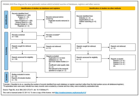
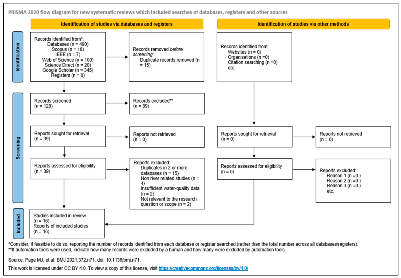
The literature review was conducted in compliance with the PRISMA 2020 guidelines [28], which provide a structured and transparent framework for the identification, screening, eligibility assessment, and inclusion of scientific studies in systematic reviews. The adoption of the PRISMA protocol ensured methodological consistency, reproducibility of the selection process, and minimization of selection bias. The PRISMA 2020 checklist (see Supplementary Material S1) and flow diagram (Figure 1) were used to guide the identification, screening, eligibility assessment, and inclusion of studies throughout the review process.
Figure 1.
PRISMA 2020 flow diagram of the current literature review [28].
The search strategy was structured around three core thematic groups of keywords corresponding to the observation platform, the target water quality variable, and the aquatic environment under investigation. The first group addressed the observation platform and included terms related to unmanned aerial systems, specifically UAV, UAS, and drones. The second group targeted the water quality parameter of interest and was restricted exclusively to chlorophyll-a, in order to maintain thematic consistency and avoid the inclusion of studies focusing on broader or indirect ecological indicators. The third group described the aquatic environment and included terms such as river, estuary, transitional waters, fluvial, and related descriptors commonly used to characterize riverine and land–sea interface systems. These keyword groups were combined using Boolean operators to identify studies that simultaneously addressed UASs with multispectral imagery, chlorophyll-a estimation, and riverine (estuary, transitional) environments.
The eligibility assessment focused on verifying the use of UAS platforms equipped with multispectral sensors, the explicit treatment of chlorophyll-a as a study variable, and the application of the methodology in riverine or transitional aquatic systems. Studies that did not meet these criteria or lacked sufficient methodological detail to support comparative analysis were excluded at this stage. The overall selection process, including the number of records identified, screened, excluded, and finally included, is summarized in the PRISMA 2020 flow diagram (Figure 1). This diagram provides a visual overview of the review workflow and documents each decision point leading to the final set of studies included in the synthesis.
The literature search was conducted between December 2025 and January 2026, ensuring the inclusion of the most recent developments in multispectral UAS applications for chlorophyll-a monitoring in riverine and transitional aquatic environments. This time frame allowed the review to capture both early methodological approaches and more recent studies reflecting advances in sensor technology, data processing workflows, and analytical techniques. Only peer-reviewed scientific publications were considered eligible for inclusion, in order to ensure the scientific robustness and reliability of the reviewed material. No restrictions were imposed on the language of publication, as studies published in languages other than English were also considered where relevant, provided that sufficient methodological detail was available for evaluation. Five databases were searched, namely, Web of Science, Scopus, ScienceDirect, IEEE Xplore, and Google Scholar, as documented in the PRISMA 2020 flow diagram (Figure 1). These databases cover a broad range of journals in the fields of remote sensing, environmental sciences, hydrology, and aquatic ecology, thereby supporting a comprehensive and multidisciplinary literature retrieval process. No review protocol was registered or defined prior to conducting this systematic review. In addition to database searching, the reference lists of all studies retained after full-text screening were examined to identify additional relevant publications that may not have been captured through the initial search queries. This backward reference screening contributed to the completeness of the review and reduced the likelihood of omitting pertinent studies within the defined thematic scope.
2.2. Screening and Eligibility
A multi-stage screening and eligibility assessment process was applied to identify studies that were thematically and methodologically aligned with the objectives of the review. The screening procedure followed the PRISMA 2020 framework and was designed to ensure transparency, consistency, and reproducibility in study selection.
In the first stage, all retrieved records were screened based on their titles and abstracts. This initial screening aimed to remove duplicate records and studies that were clearly outside the scope of the review. Articles were retained if they addressed at least one of the following thematic components: (i) the use of unmanned aerial systems as an observation platform, (ii) the investigation of chlorophyll-a using multispectral remote sensing approaches, or (iii) the application of these methods within riverine or transitional water systems. Studies that did not involve riverine, fluvial, estuarine, or transitional aquatic environments were excluded at this stage, even if they employed UAS platforms or addressed chlorophyll-a in non-fluvial settings such as lakes or coastal waters without direct river influence. In the second stage, the full texts of the remaining articles were examined in detail. During this assessment, studies were evaluated with respect to the combined presence of multispectral observations, explicit consideration of chlorophyll-a as a target variable, and application within riverine or transitional aquatic systems. Only studies satisfying all three criteria were considered eligible for inclusion in the final synthesis. Articles that did not fulfill the riverine or transitional context requirement were excluded during full-text screening, even if they met the remaining methodological criteria. The presence or absence of field-based validation, including in situ water sampling, laboratory analysis, or the use of optical or fluorometric probes, was not used as an exclusion criterion during the screening process. Studies were therefore retained regardless of whether chlorophyll-a measurements were supported by field sampling or probe-based observations, provided that the overall methodological framework aligned with the scope of the review. This approach allowed for a comprehensive assessment of methodologies, encompassing both validated and non-validated implementations. Finally, studies were assessed for their suitability to support comparative analysis within the review. Articles lacking sufficient methodological transparency, providing incomplete descriptions of key procedures related to data acquisition or image processing, or presenting results that could not be meaningfully compared with other studies were excluded at this stage. The studies that satisfied all screening and eligibility criteria were retained for qualitative synthesis and further analysis.
2.3. Data Analysis
The final dataset comprised sixteen studies, which were subsequently coded and indexed using a consistent numbering scheme (1–16) to support cross-comparison throughout the review. This numbering system was used as the primary reference key in the synthesis, allowing methodological patterns to be reported without repetitive citation of full bibliographic details (Table 1).
Table 1.
Papers examined in this review. Sixteen studies with their respective numbering for reporting purposes. The numbering will be used throughout the review instead of specific details.
A structured data extraction scheme was applied to all studies in order to identify key analytical dimensions such as the study environment, UAS platform and multispectral sensor characteristics, general data preprocessing workflows, and the overall analytical method adopted for chlorophyll-a estimation. Special emphasis was given to whether studies explored multiple retrieval approaches, such as alternative spectral indices or machine learning algorithms, as this methodological variability constitutes an important comparative factor within the review. Several studies investigated more than one algorithmic or modeling approach within the same experimental framework; therefore, algorithm type was treated as an analytical variable rather than a selection criterion. Detailed comparison and interpretation of these approaches were therefore reserved for the Results section, where algorithmic trends, methodological preferences, and reported performance are examined comparatively through the reviewed literature.
Given the heterogeneity of multispectral sensor configurations, analytical workflows, and validation practices, the analysis was based on a qualitative synthesis supported by descriptive categorization. Rather than applying predefined groupings at this stage, the extracted information was used to inform a thematic organization of the results, focusing on recurring methodological aspects such as UAS deployment characteristics, multispectral sensor properties, chlorophyll-a estimation strategies, and algorithmic approaches. This framework allowed methodological trends to be examined comparatively in the Results section, while avoiding over-generalization across studies that differ substantially in spatial scale, environmental context, and data availability.
3. Results
3.1. Spatiotemporal Trends of Publications
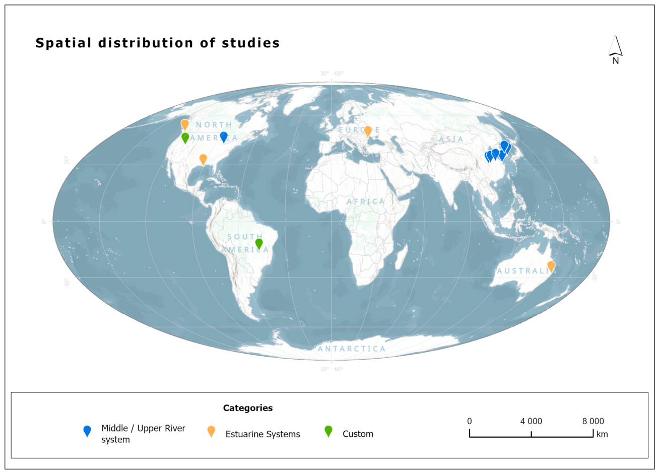
The spatiotemporal distribution of the studies included in this review provides essential context for understanding how multispectral chlorophyll-a research into riverine systems has evolved, with a focus on transitional riverine environments. By examining when and where relevant studies have been conducted, this section situates the reviewed literature within its broader temporal evolution and geographical scope, without yet addressing methodological or analytical differences among studies.
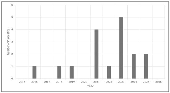
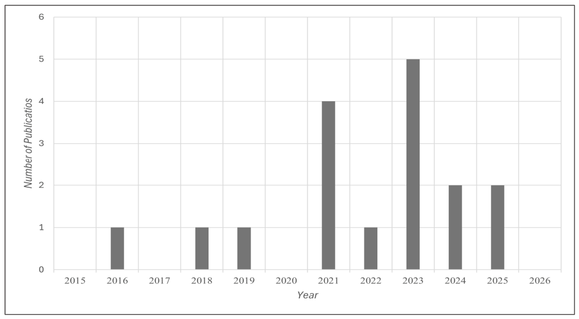
The temporal distribution of publications reveals a recently emerging body of literature, characterized by limited and sporadic research output prior to 2020. Only isolated studies were published between 2016 and 2019, reflecting exploratory, case-specific applications rather than a consolidated research focus, particularly with respect to transitional riverine environments. A pronounced acceleration in publication activity is observed from 2021 onwards, with a marked increase in the number of studies and a clear peak in 2023, followed by sustained output in subsequent years. This temporal pattern indicates a transition from isolated proof-of-concept investigations toward more systematic research efforts addressing chlorophyll-a dynamics using multispectral data (Figure 2).
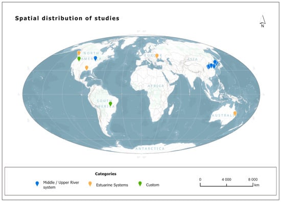
Figure 2.
Global spatial distribution of the reviewed studies, categorized by study environment (middle/upper river systems, estuarine systems, and custom studies), highlighting their geographical concentration.
The observed acceleration in publication activity after 2020 may, in part, be associated with broader regulatory and technological developments that facilitated the operational use of unmanned aerial systems for environmental monitoring. The introduction of European Union UAS regulations by the European Union Aviation Safety Agency (EASA), notably Regulations (EU) 2019/947 and 2019/945, provided a unified legal framework for UAS operations across Member States and reduced administrative uncertainty for research deployments. In parallel, decreasing sensor costs, improved radiometric performance of multispectral instruments, and the maturation of photogrammetric and radiometric processing workflows lowered technical and financial barriers to data acquisition. At the same time, differences in operational practices across research groups remain evident. Several recent studies conducted in East Asia, particularly in China (6), tend to employ relatively low flight altitudes in order to achieve very fine ground sampling distances and detailed pixel-level representations of narrow river channels and small-scale water quality gradients. These developments contributed to the wider adoption of UAS-based approaches and supported a shift toward multi-site and multi-temporal investigations in riverine and transitional water systems.
The increase in research activity after 2020 also coincides with major global policy and sustainability frameworks that have reshaped priorities in riverine water quality assessment (Figure 3). At the international level, the United Nations 2030 Agenda for Sustainable Development explicitly prioritizes the improvement of ambient water quality through Sustainable Development Goal 6, reinforcing the need for harmonized and scalable indicators applicable to inland and transitional waters worldwide [45]. In parallel, recent global policy assessments have framed water quality degradation in river basins as a systemic risk with environmental, economic, and societal implications, highlighting persistent gaps in monitoring capacity and data availability [46]. Collectively, these global frameworks have contributed to increased scientific attention on approaches capable of providing spatially explicit and scalable information on key water quality indicators, including chlorophyll-a, in riverine and transitional systems.
Figure 3.
Number of publications per year.
3.2. UAS Employment
Recording and monitoring of brackish, transitional, or river waters, as well as the depiction of chlorophyll that is concentrated in these systems using remote sensing methods, is a complex process that requires high programming and demanding data processing. The extensive literature review carried out in this article reports the acquisition of multispectral data of higher spatial resolution collected with unmanned aircraft systems.
More specifically, in 2016, to achieve data clarity on mapping a continuous river water surface, the spatial resolution of the images collected is approximately 15 cm. The authors reported that the overlap rate was 70% front and 75% side. Another element described is that this experiment was conducted at only two time points and relied solely on the RED and NIR bands (1). In 2018, a study highlighted the use of UAS for mapping NDVI and Chl-a proxies in riparian systems (2) at a high flight altitude of 150 m, 80% and 70% overlap, and a ground sampling distance (GSD) of 11.3 cm. This study examined two flights with the same technical characteristics at different times of the day, concluding that midday shots yield better primary data. A year later, Becker et al. [31] (3) attempted to map water quality in the Great Lakes of the United States using a different approach. They made low flights in different parts of the study area without following a specific flight plan but taking shots at flight heights from 2–10 m, capturing the area of interest (10 different parts of the total area) with a multispectral and hyperspectral image. In 2021, at Nae Seong Stream, South Korea, Eun Ju Kim et al. [32] (4) attempted to map chlorophyll following a flight plan with a UAS at 150 m. This flight took place in the morning hours (08:00–09:00), and the flight path was parallel lines with 75% frontal and 65% lateral overlap with the camera sensor vertical to the ground. In addition, the resolution of the images was 15 cm, which corresponds to a mapping scale of 1:3000. Windle and Silsbe (5), in the same year, used different equipment (Phantom 4 Pro) to which the MicaSense RedEdge-MX multispectral sensor (MicaSense, Inc., Seattle, WA, USA) was attached. They obtained images from 70 m without following a specific flight plan. More specifically, they took fixed vertical shots at points of interest every 2 s for 1 min. In the Nanfei River in Hefei, China, two studies illustrated a gradual evolution in the use of UASs for monitoring water quality. In the first study, a multirotor UAS equipped with a multispectral sensor was used to acquire high-resolution imagery, with flights conducted at approximately 165 m altitude and a spatial resolution of about 10 cm. The collected multispectral data were combined with in situ measurements to estimate water quality parameters (6). In the second study (13), UAS surveys were expanded to additional river sections and different acquisition periods, producing more extensive multispectral orthomosaics of the river corridor. In the following years, 2022 (8) and especially in 2023, publications regarding the mapping of Chl-a using UASs seemed to increase significantly. In one of the examined studies (9), specific flight protocols are described rather than exact flight altitudes, including maintaining a slight camera deviation from nadir and orienting the camera opposite to the sun in order to reduce sun-glint effects on the water surface. In another study (10), flights were conducted at a much lower altitude of about 20 m using an RGB camera, achieving very high spatial resolution imagery (0.64 cm). In the third study (11), UAS imagery was collected at an altitude of approximately 300 m with about 70% image overlap following a pre-planned grid flight pattern to acquire multispectral and hyperspectral data. Overall, these flight configurations aim to ensure the acquisition of high-resolution datasets suitable for the mapping and analysis of water quality parameters such as chlorophyll-a. At the same time, in Europe, Latin America, and Canada, individual works appeared, which aimed, on the one hand, to create high-resolution digital terrain models to identify microphytobenthos patterning (UAS-acquired imagery with photogrammetry provides accurate measures of mudflat elevation gradients and microtopography) and, on the other hand, to monitor water quality over time (12). The characteristics of the flights they report are specific, such as the flight altitude for the creation of the DEM, which was made at 110 m, and a grid-shaped flight pattern. These data were suitable for photogrammetric processing and provided spatial analysis suitable for microtopographic studies. In the other two cases that focused more on water quality, the flights were low, as they were carried out over water tanks or bodies of water. These also followed a flight plan with overlapping images, as their goal was to map multitemporally and produce orthomosaics. Following this, in 2024, a study in the subtropical estuarine system of Hearnes Lake (Australia) systematically mapped flights with a DJI Phantom 4 Multispectral UAS at low altitude (60–80 m) with high image overlaps (75–85% front and 70–80% side) to fully cover the lagoon and its channels, producing very high-resolution orthomosaics (3.7 cm/pixel) with RTK georeferencing (2 cm accuracy) and radiometric calibration, allowing detailed spatial mapping of water quality parameters and the production of predictive maps for chlorophyll, algae, and key physicochemical indicators (14). Two more reports were noted in 2025: (15) and (16). Specifically, in the estuarine muddy tidal formation of the Fraser River, in Canada, repeated UAS flights were carried out over selected plots (300 × 500 m) using a multispectral sensor with 10 bands. The flights were performed at a flight height of 90 m, with 90% frontal and 90% lateral coverage, while the pattern used was in a grid format. The GSD of the images was 6 cm, allowing the creation of coherent orthomosaics and high-precision DSM. The flights were repeated hourly during the tidal cycle, allowing the monitoring of intraday changes in microphytobenthic biomass. Finally, the last report recorded in the same year concerns the mapping of the tidal coastal environment. The flights were carried out with a UAS equipped with a 10-band multispectral sensor, following a grid flight pattern with high image overlap to produce orthomosaics of high spectral and spatial resolution. Flights were conducted at various flight altitudes of 50–100 m, achieving a spatial resolution of a few centimeters, while radiometric calibration was applied for accurate reflectance retrieval. The methodology allowed the mapping of photosynthetic pigment sediments and their correlation with biogeochemical processes and dynamics of the intertidal environment (Table 2).
Table 2.
The table summarizes the flight characteristics reported across the reviewed studies. A general tendency toward lower flight altitudes and finer spatial resolutions is observed, reflecting the need to capture small-scale variability in riverine environments.
A considerable number of studies failed to report their flight data in sufficient detail, thereby limiting the ability to discern methodological approaches that could be generalized or adopted as standardized protocols for meaningful comparison of results.
3.3. Multispectral Sensors
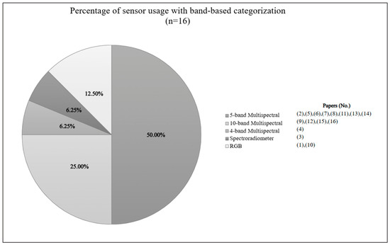
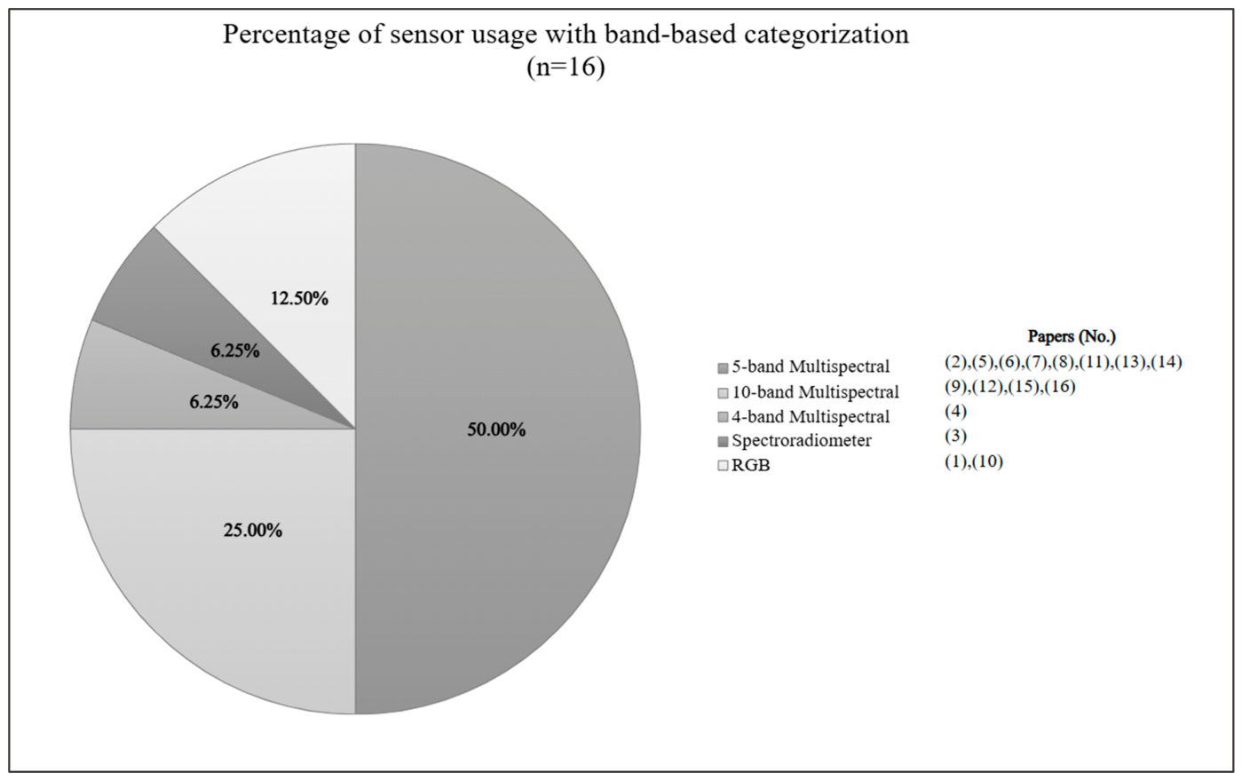
The analysis reveals a clear technological pattern regarding the spectral systems employed for chlorophyll-a detection and estimation in riverine and transitional environments. As illustrated in Figure 4, a dominant reliance on dedicated multispectral platforms is spotted. Thirteen (13) out of sixteen (16) studies (81.25%) employed multispectral sensors as their primary data acquisition systems ((2), (4)–(9), (11)–(16)). Among these thirteen (13) studies, five-band multispectral configurations represent the most frequently adopted approach, representing 50% of the reviewed studies ((2), (5)–(8), (11), (13), (14)). These systems were predominantly based on the MicaSense RedEdge family and the DJI Phantom 4 Multispectral platform, providing discrete spectral channels in the blue, green, red, red-edge, and near-infrared regions, which enable the computation of established indices such as NDVI and NDRE. Their widespread adoption indicates that five-band configurations have effectively become the operational standard for UAS-based chlorophyll-a applications in fluvial environments. Advanced ten-band multispectral systems account for 25% of the studies ((9), (12), (15), (16)), mainly in more recent intertidal and biofilm-oriented investigations. Only one study (6.25%) relied heavily on a spectroradiometer mounted on a UAS (3), while two studies (12.5%) employed low-cost RGB cameras without dedicated multispectral capability ((1), (10)).
Figure 4.
Pie chart depicting the percentage of sensors used in each study reviewed. A circular data visualization is used to show the proportional distribution of different sensor types divided by a total sum of studies n = 16 (100%) into slices, where the size of each slice represents the percentage of sensors in that category.
The latter represent either earlier methodological stages or low-cost alternatives and lack narrow-band spectral discrimination, limiting their capacity for robust reflectance-based modeling. The literature demonstrates a clear predominance of MicaSense multispectral sensors ((2), (5)–(7), (9), (12), (13), (15), (16)), followed by DJI Phantom 4 Multispectral platforms ((8), (11), (14)), with occasional use of the Parrot Sequoia (4) and isolated hyperspectral deployments such as the Ocean Optics STS (3) and Cubert ULTRIS X20 (11). Collectively, these findings indicate a pronounced methodological consolidation around dedicated multispectral sensors mounted on UAS systems, while hyperspectral and RGB-based configurations remain marginal within the current body of research.
3.4. Utilized Indexes, Algorithms, and Machine Learning
The methodological synthesis of the sixteen reviewed studies reveals a field that remains predominantly empirical, with limited standardization across spectral, radiometric, and modeling dimensions. The comparative assessment across the three analytical axes—(i) spectral indices and band mathematics, (ii) radiometric processing and reflectance retrieval, and (iii) statistical and machine learning modeling—highlights both patterns of convergence and critical methodological gaps.
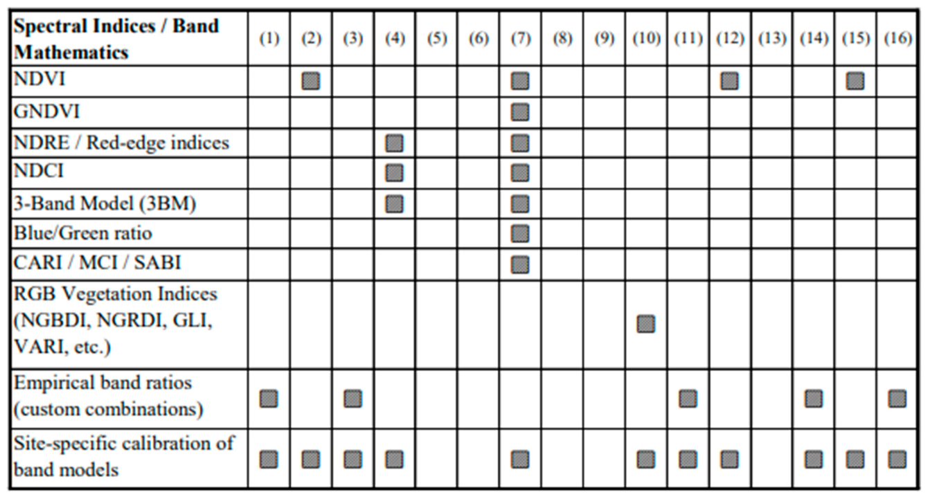
The analysis of spectral strategies demonstrates a heterogeneous and index-driven landscape (Figure 5). Explicit spectral indices or predefined band-based formulations are employed in ten of the sixteen studies (62.5%). The prevalence of red-edge (RE) and near-infrared (NIR) spectral strategies among the reviewed studies suggests that most empirical formulations are indirectly grounded in the bio-optical behavior of chlorophyll-a, particularly its strong absorption feature near 665 nm and reflectance peak in the 700–730 nm region. However, despite this common spectral rationale, the reviewed literature still demonstrates substantial fragmentation in band selection and calibration procedures, limiting methodological transferability across riverine systems. NDVI and related vegetation-type metrics represent the most frequently applied spectral approach, appearing in four studies (25%). Indices based on the red-edge spectrum, including NDRE and NDCI, are implemented in two studies (12.5%), reflecting sensor availability rather than the adoption of a unified aquatic monitoring framework. Beyond these commonly reported indices, spectral strategies remain fragmented. Custom empirical band ratios are used in six studies (37.5%), while RGB-based vegetation proxies appear in one case (6.25%). This diversity indicates methodological experimentation rather than consolidation around standardized aquatic chlorophyll retrieval algorithms. Site-specific calibration of spectral relationships is reported in eleven of the sixteen studies (68.75%), confirming that most spectral formulations are locally optimized. In many cases, band combinations are selected based on correlation strength and model fit rather than grounded in bio-optical constraints. Cross-site validation and inter-system transferability testing are rarely addressed. As a result, although empirical band mathematics provides operationally effective results at local scales, the absence of standardized spectral frameworks limits broader comparability and methodological generalization across riverine systems.
Figure 5.
Spectral indices and band mathematics across the reviewed studies.
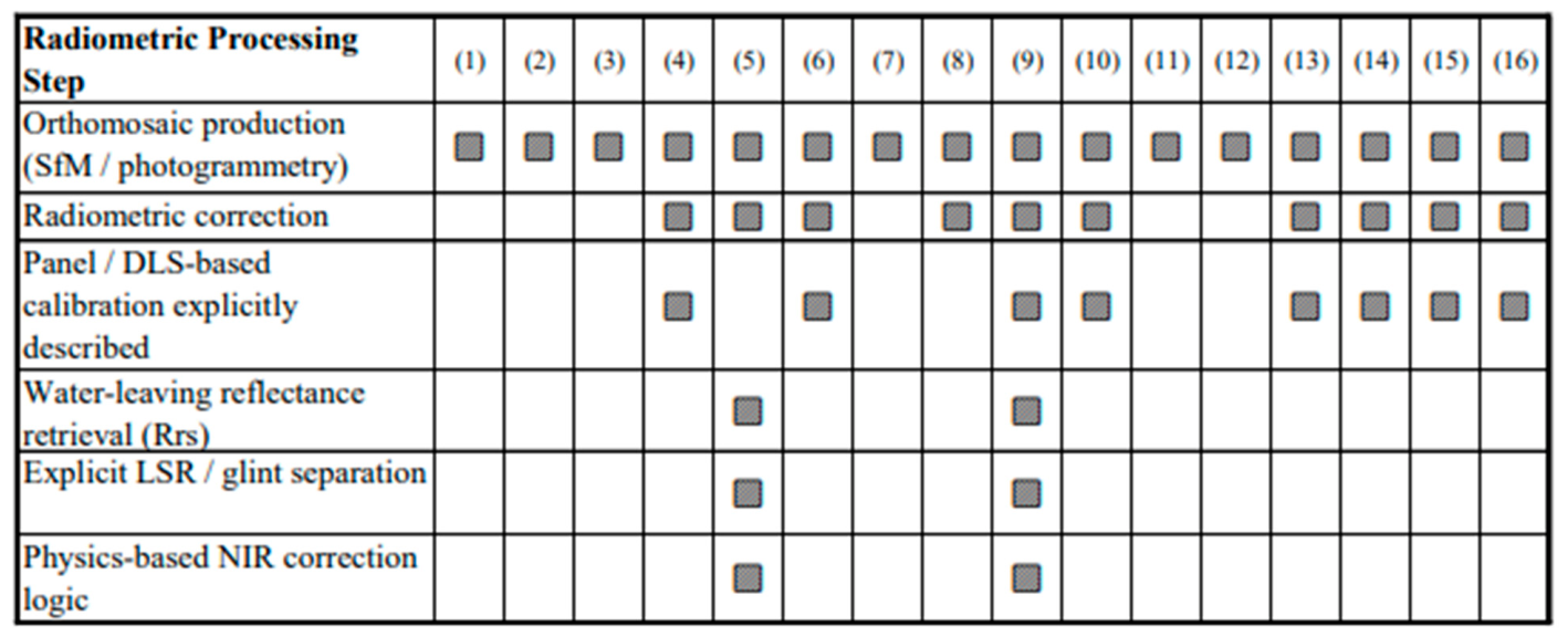
All reviewed studies generate orthomosaics through the Structure-from-Motion (SfM) algorithm as a fundamental preprocessing step (Figure 6). However, substantial divergence emerges at the level of radiometric treatment. Explicit radiometric correction, involving conversion from digital numbers to calibrated reflectance using reflectance panels or downwelling light sensors, is described in nine of the sixteen studies (56.25%). Although this reflects growing awareness of reflectance normalization, the depth of radiometric processing varies considerably. In several cases, calibration relies primarily on manufacturer-provided workflows or panel-based scaling without further correction of surface-reflected components. Only two studies (12.5%) implement full water-leaving reflectance retrieval, including explicit separation of water-leaving radiance from surface-reflected radiance or sky-glint contributions. These studies incorporate physics-based correction logic, including NIR-based approaches suitable for optically complex waters. The remaining studies operate on calibrated surface reflectance products without formal signal decomposition. This distinction is methodologically significant. Without explicit removal of surface-reflected radiance, spectral indices derived from UAS imagery may integrate mixed optical contributions, thereby reducing physical comparability across sites and constraining model transferability. Geometric processing appears technically mature and standardized, whereas radiometric rigor remains uneven and not yet systematically aligned with radiative transfer principles.
Figure 6.
Radiometric processing and reflectance retrieval.
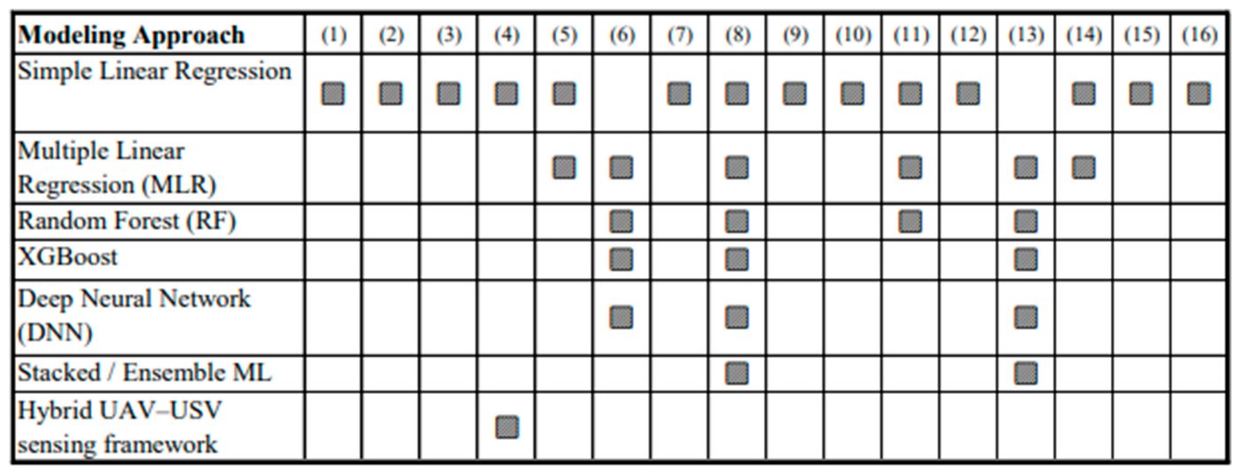
Modeling dimension reveals a clear dominance of regression-based approaches (Figure 7). Simple linear regression is employed in fourteen of the sixteen studies (87.5%), typically linking spectral indices or empirical band ratios directly to in situ chlorophyll-a measurements. Multiple linear regression is applied in five studies (31.25%) to incorporate multiple spectral predictors. In contrast, advanced machine learning frameworks, including Random Forest, XGBoost, deep neural networks, and ensemble stacking, are implemented in only three studies (18.75%).
Figure 7.
Statistical and machine learning modeling approaches across the reviewed studies.
These applications are predominantly reported in publications after 2021, suggesting an emerging methodological shift rather than established practice. Even within these studies, machine learning models are frequently benchmarked against traditional regression baselines, indicating that parametric linear modeling remains the reference framework.
Formal model selection and optimization strategies are reported in only a limited subset of cases. Although performance metrics such as R2 and RMSE are widely presented, systematic uncertainty analysis, cross-site validation, and transferability assessment remain underexplored. Consequently, although modeling performance is often quantified, robustness and generalizability are seldom evaluated in a comprehensive manner.
3.5. Chl-a in Riverine Systems
In riverine and estuarine waters, Chl-a dynamics are particularly complex due to the combined influence of freshwater inflows, tidal mixing, riparian vegetation, suspended sediments, and variable nutrient loading [47,48]. These interactions generate strong spatial and temporal gradients in light availability and phytoplankton composition, often resulting in highly heterogeneous Chl-a distributions compared with lakes or open coastal waters [49].
Assessing the sixteen studies included in this review, most focused on estimating chlorophyll-a as a primary indicator of algal biomass, while others examined related biological parameters such as cyanobacteria pigments, macroalgal biomass or benthic photopigments. Across these studies, nine of them ((3), (5), (7), (9), (12–16)) were conducted in transitional riverine or estuarine environments, including river deltas, estuarine river reaches, and intertidal zones influenced by both freshwater and marine processes. The remaining seven studies ((1), (2), (4), (6), (8), (10), (11)) were conducted in riverine freshwater environments rather than transitional water systems.
3.5.1. In Situ and Laboratory Methods of Measurements
Field sampling formed a fundamental component of all studies included for the assessment and estimation of Chl-a, regardless of whether Chl-a determination was performed in situ or in the laboratory. Two principal field approaches were identified: direct in situ fluorometric measurements and discrete water sampling followed by laboratory analysis. Direct in situ Chl-measurements were conducted in five studies ((1), (3), (4), (10), (15)), primarily using fluorometric or multiparameter probes (e.g., FluoroProbe, ECO fluorometer). These scientific instruments were deployed from boats, unmanned surface vehicles, or directly within mesocosms, enabling real-time Chl-a estimation along river transects or within controlled experimental systems.
In contrast, ten (10) studies ((2), (4–9), (11), (13), (16)) relied on discrete water sampling as the primary field method for subsequent laboratory analysis. Water samples were collected from the surface layer or from shallow depths, commonly around 0.3–0.5 m ((5), (6), (8), (11), (13)), although many studies did not explicitly report the exact sampling depth. Sample volumes, where specified, typically ranged around 1 L per sampling point ((6), (8), (13)). Various sampling containers were used, including standard sampling bottles, Plexiglass water samplers, and polypropylene containers for sediment collection in intertidal environments ((5), (8), (11), (13), (16)). In several cases, methodological details regarding sampling depth, container type, or exact sample volume were not fully specified. Sampling location and field conditions varied across studies, depending on site accessibility and study design. After collection, samples were stored under dark and cooled conditions and transferred to the laboratory for pigment analysis.
It should be noted that study No. 10 [38] did not conduct sampling in the way that the other studies did, but the researchers took samples directly from a river channel. Instead, water was collected from a small oligo-mesotrophic lake formed by the damming of the Barreiro stream and transferred to 30 L mesocosm units, where chlorophyll-a measurements were performed under semi-controlled experimental conditions rather than through in-stream sampling.
3.5.2. Laboratory Processes-Data Analysis Workflows
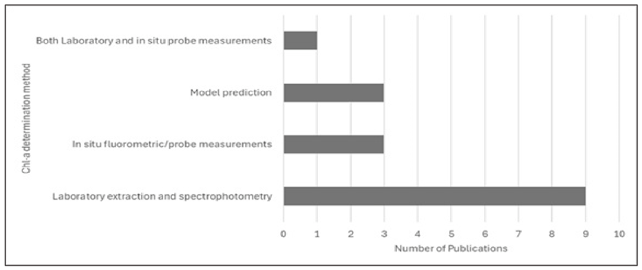
Based on the criterion of laboratory determination of chlorophyll-a, laboratory extraction followed by spectrophotometric or chromatographic analysis represented the dominant analytical approach, applied in ten of the sixteen studies included in this review. In addition, one study combined laboratory analysis with in situ fluorometric measurements, bringing the total number of studies involving laboratory determination to eleven (Figure 8).
Figure 8.
Frequency of chlorophyll-a determination methods reported in the sixteen reviewed studies. Methods include laboratory extraction and spectrophotometric analysis, in situ fluorometric or probe measurements, combined laboratory and in situ approaches, and model-based predictions.
The laboratory workflows followed established analytical procedures involving filtration onto glass-fiber filters (GF/F or GF/C) and subsequent pigment extraction. Eight studies ((2), (5–8), (13), (16)) explicitly reported the use of acetone for extraction, most commonly employing 90% acetone, followed by dark and cold incubation (e.g., up to 24 h at 4 °C) and spectrophotometric determination of chlorophyll-a using standard equations (e.g., [6,50]). In contrast, three ((4), (9), (11)) studies reported laboratory chlorophyll-a determination without specifying the extraction solvent, although spectrophotometric or standardized analytical procedures were indicated. Studies (5–8) and (13) explicitly adhered to national or international standard methods, including EPA Method 445.0, Korean National Standard Method based on NIER 2019, Chinese National Standard Method, or equivalent regulatory procedures, enhancing methodological comparability across datasets. One study (9) employed chromatographic techniques (HPLC) to improve pigment specificity and to separate chlorophyll-a from degradation products and accessory pigments in a transitional environment influenced by suspended sediments.
Chlorophyll-a concentrations measured in the laboratory exhibited substantial variability across the reviewed studies, with reported values ranging from low concentrations of approximately 1 μg L−1 to high concentrations exceeding 70 μg L−1. In other studies, chlorophyll-a was reported as areal concentrations, with values reaching up to approximately 180 mg m−2. An overview of the reported Chl-a concentration ranges and analytical methods is presented in Table 3.
Table 3.
Sampling approaches and validation strategies across the sixteen reviewed studies. The column “In situ measurement” indicates whether chlorophyll-a validation involved direct field measurements, either through discrete water sampling or in-water sensors (e.g., fluorometers or multiparameter probes). “NR” indicates information not reported in the original study.
Laboratory-based chlorophyll-a extraction methods were employed in ten of the sixteen reviewed studies (62.5%), including one study that combined laboratory analysis with in situ fluorometric measurements (Figure 8). These approaches typically involved the collection of discrete water samples followed by filtration and pigment extraction, most commonly using spectrophotometric or fluorometric techniques based on established protocols such as EPA Method 445.0 or related national standard methods. The widespread use of laboratory extraction highlights its continued role as a reference method for validating remotely sensed chlorophyll-a estimates, despite the increasing adoption of in situ probe measurements and model-based approaches in recent monitoring studies that use UASs.
4. Conclusions
Across the reviewed studies addressing chlorophyll-a in fluvial environments, multispectral imagery typically uses discrete visible, red-edge, and near-infrared bandsets that support index construction and empirical retrieval. Despite this convergence in sensor band design, the evidence base remains largely site-calibrated, and cross-study reproducibility is constrained by inconsistent radiometric pipelines, heterogeneous validation protocols, and limited use of scale-aware cartographic conventions. Using the PRISMA 2020 framework, this review compared methodological choices across the literature, highlighting how sensor selection, algorithm design, and calibration/validation practices interact under optically complex riverine and transitional conditions.
4.1. Methodological Synthesis of Multispectral Chlorophyll-a Retrieval in Riverine Systems
In the reviewed set (n = 16), most studies rely on empirical modeling built on spectral indices and band ratios that emphasize red/red-edge/NIR information, consistent with established approaches for turbid productive waters, indicating that multispectral chlorophyll-a retrieval in riverine and transitional waters remains primarily index-based. Machine learning regression appears less frequently and is commonly trained and evaluated within the source system, limiting evidence for transferability without multi-site or multi-temporal testing. Radiometric handling is a primary determinant of inter-study comparability: although reflectance calibration using panels and/or downwelling irradiance sensors is widely used in drone remote sensing, fewer aquatic workflows explicitly retrieve water-leaving reflectance by removing surface-reflected radiance and correcting for sun glint, even though these components can dominate the measured signal. Validation remains anchored in field sampling, often using laboratory pigment extraction methods such as EPA Method 445.0; however, uneven reporting of laboratory and radiometric steps complicates uncertainty attribution and comparability across studies.
4.1.1. Sensor and Algorithmic Patterns Across River Types
In inland river reaches and regulated or urban river corridors, several studies indicate that index-based regressions can support spatial mapping when optical conditions are comparatively stable and radiometric normalization is implemented consistently. These applications typically retain a small set of indices and linear models and prioritize within-site spatial pattern detection over cross-site generalization. In contrast, transitional river sections introduce greater methodological sensitivity. Increased suspended sediment loads, variable salinity gradients, and dynamic mixing processes alter reflectance signatures and may weaken index stability. Studies conducted in these environments tend to require more intensive calibration procedures or hybrid modeling strategies. Nevertheless, even in these complex systems, deterministic indices remain dominant, indicating that methodological innovation has not yet fully responded to optical heterogeneity.
4.1.2. Transitional River Sections and Estuarine Complexity
Transitional and estuarine environments are consistently characterized as optically complex: turbidity, colored dissolved organic matter, shallow water/benthic contributions, and rapidly changing illumination and hydrodynamics can confound Chl-a signals and destabilize empirical indices. Under these conditions, inland calibrated index models tend to degrade downstream, and radiometric shortcomings, particularly glint contamination, become disproportionately influential. The reviewed evidence therefore supports explicit stratification by optical regime and careful alignment of calibration/validation design with the downstream complexity of transitional reaches.
4.2. Scale, Optical Variability, and Model Transferability
Although high spatial resolution is frequently presented as a major advantage of drone-based observations, spatial scale is rarely treated explicitly as a cartographic variable. Differences in flight altitude, ground sampling distance (GSD), mapped extent, acquisition timing, and channel morphology produce datasets that are difficult to compare across studies, even when similar sensors and spectral indices are employed. Temporal scale also remains inconsistently addressed. Many studies rely on short acquisition windows or single campaign measurements, meaning that reported model performance reflects momentary optical conditions rather than seasonal or hydrological variability. Only a limited number of studies evaluate model stability across changing discharge, turbidity, or salinity regimes.
Together, these factors highlight a mismatch between the technical capacity of high-resolution imagery to resolve fine spatial structure and the limited integration of standardized scale frameworks needed for cross-study synthesis and transferable monitoring approaches.
4.3. Current Limitations and Future Directions for Riverine Monitoring
Overall, the reviewed literature indicates that although geometric processing workflows have reached a relatively high level of methodological consistency, radiometric procedures and cartographic scale considerations remain considerably less standardized. As a result, multispectral chlorophyll-a retrieval in riverine systems continues to rely largely on locally calibrated empirical models, with limited evaluation of their performance beyond the original study context. This dependence on site-specific calibration, combined with heterogeneous radiometric processing and inconsistent validation reporting, constrains the transferability of current approaches across river types and optical regimes. Advancing toward more operational monitoring frameworks therefore requires greater methodological convergence. Recent studies conducted in lakes, reservoirs, and marine environments indicate that chlorophyll-a retrieval commonly relies on multispectral or hyperspectral imagery, spectral indices derived from red, red-edge, and near-infrared wavelengths, empirical regression models, and, increasingly, machine learning approaches [51,52]. Recent UAV-based investigations have further demonstrated the potential of drone-mounted sensors for water quality assessment in non-riverine systems. For example, Ghasemnezhad et al. (2026) [53] and Mello et al. (2026) [54] successfully applied UAV multispectral imagery and machine learning models in reservoir environments for chlorophyll-a and water quality estimation, while Luque-Söllheim et al. (2025) [55] demonstrated the use of UAV-mounted hyperspectral sensors for the retrieval of chlorophyll and other water quality parameters in coastal waters. These approaches are broadly consistent with those identified in the present review, where multispectral imagery, spectral indices, statistical modeling, and machine learning techniques were the predominant methods used for chlorophyll-a estimation. Nevertheless, riverine and transitional environments present additional challenges compared with many lacustrine, reservoir, and marine systems. The strong influence of hydrological fluctuations, freshwater–marine mixing processes, suspended sediments, variable water depth, and rapidly changing water quality conditions frequently results in greater optical complexity. Furthermore, surface reflection effects, including sun-glint contamination, may introduce additional uncertainty in remotely sensed observations. The continued development of monitoring in riverine environments, including high-resolution eutrophication mapping and unsupervised classification approaches, highlights emerging opportunities for future chlorophyll-a monitoring in hydrologically dynamic systems [56]. Collectively, these factors can limit the direct transferability of retrieval models and necessitate localized calibration and validation approaches.
Future research should prioritize transparent radiometric processing workflows that explicitly address reflectance calibration and surface reflection effects such as sun glint. In parallel, algorithm robustness should be assessed through multi-site and multi-temporal validation designs capable of evaluating model performance under varying hydrological and optical conditions. Greater methodological consistency in field validation procedures, including clear reporting of water sampling depth and laboratory uncertainty estimates, would further improve the comparability and transferability of chlorophyll-a retrieval models. Improving methodological consistency and transferability is not only a technical requirement but also a prerequisite for sustainable environmental monitoring, enabling reliable, scalable, and decision-support-ready observations of riverine systems under ongoing environmental and climatic pressures. Finally, cartographic scale considerations should be integrated more explicitly into study design and reporting practices, ensuring that parameters such as ground sampling distance, mapped extent, acquisition timing, and associated uncertainties are treated as essential methodological descriptors rather than incidental acquisition settings.
Supplementary Materials
The following supporting information can be downloaded at: https://www.mdpi.com/article/10.3390/su18126234/s1, Supplementary Material S1: PRISMA 2020 Checklist.
Author Contributions
Conceptualization, M.D.S. and O.T.; investigation, M.D.S.; writing—original draft preparation, M.D.S., E.E.P., A.P., and S.P.; writing—review and editing, M.D.S., O.T., A.P., E.E.P., S.P., N.S., and G.T.; resources, M.D.S.; verification, M.D.S. and O.T.; visualization, M.D.S., A.P., E.E.P., and S.P.; supervision, O.T. All authors have read and agreed to the published version of the manuscript.
Funding
This research received no external funding.
Institutional Review Board Statement
Not applicable.
Informed Consent Statement
Not applicable.
Data Availability Statement
The data utilized for this Review are drawn from a comprehensive search encompassing various databases and sources. The included studies, references, and relevant information extracted are publicly accessible and retrievable through the respective databases or repositories referenced in the bibliography.
Acknowledgments
During manuscript preparation, the authors used ChatGPT 5.2 to improve clarity and grammar and Mendeley v2.144.0 for reference management. Senior researcher O.T. and young researcher M.-D. S. used hardware provided thanks to ECO-BEACHTECH Action, a part of the INTERREG VI-A Cooperation Program “Greece-Cyprus 2021-2027”. The authors have reviewed and edited the output and take full responsibility for the content of this publication.
Conflicts of Interest
The authors declare no conflict of interest.
References
- Allan, J.D.; Castillo, M.M.; Capps, K.A. Stream Ecology: Structure and Function of Running Waters, 3rd ed.; Springer International Publishing: New York, NY, USA, 2020. [Google Scholar]
- Vannote, R.L.; Minshall, G.W.; Cummins, K.W.; Sedell, J.R.; Cushing, C.E. The River Continuum Concept. Can. J. Fish. Aquat. Sci. 1980, 37, 130–137. [Google Scholar] [CrossRef] [Scilit]
- Hinrich Kaplan, N.; Sohrt, E.; Blume, T.; Weiler, M. Monitoring Ephemeral, Intermittent and Perennial Streamflow: A Dataset from 182 Sites in the Attert Catchment, Luxembourg. Earth Syst. Sci. Data 2019, 11, 1363–1374. [Google Scholar] [CrossRef] [Scilit]
- Dietrich, M.; Golden, H.E.; Christensen, J.R.; Lane, C.R.; Dumelle, M. Lake Chlorophyll-a Linked to Upstream Nutrients across the Conterminous United States. Environ. Sci. Technol. Lett. 2024, 11, 1406–1412. [Google Scholar] [CrossRef] [Scilit] [PubMed]
- Wu, J.; Jiang, D.; Cai, Z.; Lv, J.; Liu, G.; Li, B. Eutrophication Assessment Revealed by the Distribution of Chlorophyll-a in the South China Sea. Remote Sens. 2025, 17, 3388. [Google Scholar] [CrossRef] [Scilit]
- Arar, E.J. Method 446.0: In Vitro Determination of Chlorophylls a, b, c + c and Pheopigments in Marine and Freshwater Algae by Visible Spectrophotometry; US Environmental Protection Agency: Washington, DC, USA, 1997. [Google Scholar]
- Lorenzen, C.J. Determination of Chlorophyll and Pheo-pigments: Spectrophotometric Equations. Limnol. Oceanogr. 1967, 12, 343–346. [Google Scholar] [CrossRef] [Scilit]
- Strickland, J.D.H.; Parsons, T.R. A Practical Hand Book of Seawater Analysis; Fisheries Research Board of Canada Bulletin: Ottawa, ON, USA, 1972; Volume 167, Available online: https://epic.awi.de/id/eprint/39262/1/Strickland-Parsons_1972.pdf (accessed on 23 November 2025).
- Liu, X.; Steele, C.; Simis, S.; Warren, M.; Tyler, A.; Spyrakos, E.; Selmes, N.; Hunter, P. Retrieval of Chlorophyll-a Concentration and Associated Product Uncertainty in Optically Diverse Lakes and Reservoirs. Remote Sens. Environ. 2021, 267, 112710. [Google Scholar] [CrossRef] [Scilit]
- Llodrà-Llabrés, J.; Martínez-López, J.; Postma, T.; Pérez-Martínez, C.; Alcaraz-Segura, D. Retrieving Water Chlorophyll-a Concentration in Inland Waters from Sentinel-2 Imagery: Review of Operability, Performance and Ways Forward. Int. J. Appl. Earth Obs. Geoinf. 2023, 125, 103605. [Google Scholar] [CrossRef] [Scilit]
- Mobley, C.D. Estimation of the Remote-Sensing Reflectance from above-Surface Measurements. Appl. Opt. 1999, 38, 7442–7455. [Google Scholar] [CrossRef] [Scilit] [PubMed]
- Odermatt, D.; Gitelson, A.; Brando, V.E.; Schaepman, M. Review of Constituent Retrieval in Optically Deep and Complex Waters from Satellite Imagery. Remote Sens. Environ. 2012, 118, 116–126. [Google Scholar] [CrossRef] [Scilit]
- Matthews, M.W. A Current Review of Empirical Procedures of Remote Sensing in Inland and Near-Coastal Transitional Waters. Int. J. Remote Sens. 2011, 32, 6855–6899. [Google Scholar] [CrossRef] [Scilit]
- Gitelson, A.A.; Gurlin, D.; Moses, W.J.; Barrow, T. A Bio-Optical Algorithm for the Remote Estimation of the Chlorophyll-a Concentration in Case2 Waters. Environ. Res. Lett. 2009, 4, 045003. [Google Scholar] [CrossRef] [Scilit]
- Mishra, S.; Mishra, D.R. Normalized Difference Chlorophyll Index: A Novel Model for Remote Estimation of Chlorophyll-a Concentration in Turbid Productive Waters. Remote Sens. Environ. 2012, 117, 394–406. [Google Scholar] [CrossRef] [Scilit]
- European Parliament; Council of the European Union. Directive 2000/60/EC. In Official Journal of the European Communities; Office for Official Publications of the European Communities: Luxembourg, 2000; pp. 1–73. [Google Scholar]
- Acharya, B.S.; Bhandari, M.; Bandini, F.; Pizarro, A.; Perks, M.; Joshi, D.R.; Wang, S.; Dogwiler, T.; Ray, R.L.; Kharel, G.; et al. Unmanned Aerial Vehicles in Hydrology and Water Management: Applications, Challenges, and Perspectives. Water Resour. Res. 2021, 57, e2021WR029925. [Google Scholar] [CrossRef] [Scilit]
- Vélez-Nicolás, M.; García-López, S.; Barbero, L.; Ruiz-Ortiz, V.; Sánchez-Bellón, Á. Applications of Unmanned Aerial Systems (UASs) in Hydrology: A Review. Remote Sens. 2021, 13, 1359. [Google Scholar] [CrossRef] [Scilit]
- Mishra, V.; Avtar, R.; Prathiba, A.P.; Mishra, P.K.; Tiwari, A.; Sharma, S.K.; Singh, C.H.; Chandra Yadav, B.; Jain, K. Uncrewed Aerial Systems in Water Resource Management and Monitoring: A Review of Sensors, Applications, Software, and Issues. Adv. Civ. Eng. 2023, 2023, 3544724. [Google Scholar] [CrossRef] [Scilit]
- Talavera, L.; Domínguez-Gómez, J.A.; Navarro, N.; Rodríguez-Santalla, I. Analysing Spatiotemporal Variability of Chlorophyll-a Concentration and Water Surface Temperature in Coastal Lagoons of the Ebro Delta (NW Mediterranean Sea, Spain). J. Mar. Sci. Eng. 2024, 12, 941. [Google Scholar] [CrossRef] [Scilit]
- Gitelson, A.A.; Dall’Olmo, G.; Moses, W.; Rundquist, D.C.; Barrow, T.; Fisher, T.R.; Gurlin, D.; Holz, J. A Simple Semi-Analytical Model for Remote Estimation of Chlorophyll-a in Turbid Waters: Validation. Remote Sens. Environ. 2008, 112, 3582–3593. [Google Scholar] [CrossRef] [Scilit]
- Murphy, J.C.; Gorney, R.M.; Lucas, L.A.; Zwart, J.A.; Graham, J.L. A Systematic Literature Review of Forecasting and Predictive Models of Harmful Algal Blooms in Flowing Waters. BioRxiv 2025. [Google Scholar] [CrossRef] [Scilit]
- Ngwenya, N.; Bangira, T.; Sibanda, M.; Kebede Gurmessa, S.; Mabhaudhi, T. UAV-Based Remote Sensing of Chlorophyll-a Concentrations in Inland Water Bodies: A Systematic Review. Geocarto Int. 2025, 40, 2452246. [Google Scholar] [CrossRef] [Scilit]
- Wu, D.; Li, R.; Zhang, F.; Liu, J. A Review on Drone-Based Harmful Algae Blooms Monitoring. Environ. Monit. Assess. 2019, 191, 211. [Google Scholar] [CrossRef] [Scilit] [PubMed]
- Spyrakos, E.; O’Donnell, R.; Hunter, P.D.; Miller, C.; Scott, M.; Simis, S.G.H.; Neil, C.; Barbosa, C.C.F.; Binding, C.E.; Bradt, S.; et al. Optical Types of Inland and Coastal Waters. Limnol. Oceanogr. 2018, 63, 846–870. [Google Scholar] [CrossRef] [Scilit]
- Goodchild, M.F. Spatial Autocorrelation; Geo Books: Norwich, UK, 1986. [Google Scholar]
- Goodchild Scale in GIS: An Overview. Geomorphology 2011, 130, 5–9. [CrossRef] [Scilit]
- Page, M.J.; McKenzie, J.E.; Bossuyt, P.M.; Boutron, I.; Hoffmann, T.C.; Mulrow, C.D.; Shamseer, L.; Tetzlaff, J.M.; Akl, E.A.; Brennan, S.E.; et al. The PRISMA 2020 Statement: An Updated Guideline for Reporting Systematic Reviews. BMJ 2021, 372, n71. [Google Scholar] [CrossRef] [Scilit] [PubMed]
- Kim, H.-M.; Yoon, H.-J.; Jang, S.W.; Kwak, S.N.; Sohn, B.Y.; Kim, S.G.; Kim, D.H. Application of Unmanned Aerial Vehicle Imagery for Algal Bloom Monitoring in River Basin. Int. J. Control Autom. 2016, 9, 203–220. [Google Scholar] [CrossRef] [Scilit]
- Choo, Y.; Kang, G.; Kim, D.; Lee, S. A Study on the Evaluation of Water-Bloom Using Image Processing. Environ. Sci. Pollut. Res. 2018, 25, 36775–36780. [Google Scholar] [CrossRef] [Scilit] [PubMed]
- Becker, R.H.; Sayers, M.; Dehm, D.; Shuchman, R.; Quintero, K.; Bosse, K.; Sawtell, R. Unmanned Aerial System Based Spectroradiometer for Monitoring Harmful Algal Blooms: A New Paradigm in Water Quality Monitoring. J. Gt. Lakes Res. 2019, 45, 444–453. [Google Scholar] [CrossRef] [Scilit]
- Kim, E.J.; Nam, S.H.; Koo, J.W.; Hwang, T.M. Hybrid Approach of Unmanned Aerial Vehicle and Unmanned Surface Vehicle for Assessment of Chlorophyll-a Imagery Using Spectral Indices in Stream, South Korea. Water 2021, 13, 1930. [Google Scholar] [CrossRef] [Scilit]
- Windle, A.E.; Silsbe, G.M. Evaluation of Unoccupied Aircraft System (UAS) Remote Sensing Reflectance Retrievals for Water Quality Monitoring in Coastal Waters. Front. Environ. Sci. 2021, 9, 674247. [Google Scholar] [CrossRef] [Scilit]
- Chen, B.; Mu, X.; Chen, P.; Wang, B.; Choi, J.; Park, H.; Xu, S.; Wu, Y.; Yang, H. Machine Learning-Based Inversion of Water Quality Parameters in Typical Reach of the Urban River by UAV Multispectral Data. Ecol. Indic. 2021, 133, 108434. [Google Scholar] [CrossRef] [Scilit]
- Choe, E.; Jung, K.M.; Yoon, J.-S.; Jang, J.H.; Kim, M.-J.; Lee, H.J. Application of Spectral Indices to Drone-Based Multispectral Remote Sensing for Algal Bloom Monitoring in the River. Korean J. Remote Sens. 2021, 37, 419–430. [Google Scholar] [CrossRef]
- Xiao, Y.; Guo, Y.; Yin, G.; Zhang, X.; Shi, Y.; Hao, F.; Fu, Y. UAV Multispectral Image-Based Urban River Water Quality Monitoring Using Stacked Ensemble Machine Learning Algorithms—A Case Study of the Zhanghe River, China. Remote Sens. 2022, 14, 3272. [Google Scholar] [CrossRef] [Scilit]
- De Keukelaere, L.; Moelans, R.; Knaeps, E.; Sterckx, S.; Reusen, I.; De Munck, D.; Simis, S.G.H.; Constantinescu, A.M.; Scrieciu, A.; Katsouras, G.; et al. Airborne Drones for Water Quality Mapping in Inland, Transitional and Coastal Waters—MapEO Water Data Processing and Validation. Remote Sens. 2023, 15, 1345. [Google Scholar] [CrossRef] [Scilit]
- Cobelo, I.; Machado, K.B.; David, A.C.M.; Carvalho, P.; Ferreira, M.E.; Nabout, J.C. Unmanned Aerial Vehicles and Low-Cost Sensor as Tools for Monitoring Freshwater Chlorophyll-a in Mesocosms with Different Trophic State. Int. J. Environ. Sci. Technol. 2023, 20, 5925–5936. [Google Scholar] [CrossRef] [Scilit]
- Xiao, Y.; Chen, J.; Xu, Y.; Guo, S.; Nie, X.; Guo, Y.; Li, X.; Hao, F.; Fu, Y.H. Monitoring of Chlorophyll-a and Suspended Sediment Concentrations in Optically Complex Inland Rivers Using Multisource Remote Sensing Measurements. Ecol. Indic. 2023, 155, 111041. [Google Scholar] [CrossRef] [Scilit]
- Douglas, T.J.; Coops, N.C.; Drever, M.C. UAV-Acquired Imagery with Photogrammetry Provides Accurate Measures of Mudflat Elevation Gradients and Microtopography for Investigating Microphytobenthos Patterning. Sci. Remote Sens. 2023, 7, 100089. [Google Scholar] [CrossRef] [Scilit]
- Chen, P.; Wang, B.; Wu, Y.; Wang, Q.; Huang, Z.; Wang, C. Urban River Water Quality Monitoring Based on Self-Optimizing Machine Learning Method Using Multi-Source Remote Sensing Data. Ecol. Indic. 2023, 146, 109750. [Google Scholar] [CrossRef] [Scilit]
- Giles, A.B.; Correa, R.E.; Santos, I.R.; Kelaher, B. Using Multispectral Drones to Predict Water Quality in a Subtropical Estuary. Environ. Technol. 2024, 45, 1300–1312. [Google Scholar] [CrossRef] [Scilit] [PubMed]
- Douglas, T.J.; Coops, N.C.; Drever, M.C.; Hunt, B.P.V.; Martin, T.G.; Elner, R.W. Uncovering Intra-Daily Intertidal Biofilm Dynamics in a Shorebird Foraging Hotspot with Hourly UAV Multispectral Imagery Acquisitions. Int. J. Appl. Earth Obs. Geoinf. 2025, 142, 104755. [Google Scholar] [CrossRef] [Scilit]
- Douglas, T.J.; Coops, N.C.; Drever, M.C. Assessing Intertidal Sediment Photopigment Content from Spectral Reflectance with an UAV-Mounted 10-Band Multispectral Sensor. Remote Sens. Lett. 2025, 16, 109–124. [Google Scholar] [CrossRef] [Scilit]
- United Nations. Transforming Our World: The 2030 Agenda for Sustainable Development; United Nations: New York, NY, USA, 2015. [Google Scholar]
- OECD. Embedding Water-Related Risks in Financial Stability Frameworks; OECD: Paris, France, 2025. [Google Scholar]
- Cloern, J.E.; Foster, S.Q.; Kleckner, A.E. Phytoplankton Primary Production in the World’s Estuarine-Coastal Ecosystems. Biogeosciences 2014, 11, 2477–2501. [Google Scholar] [CrossRef] [Scilit]
- Gameiro, C.; Cartaxana, P.; Cabrita, M.T.; Brotas, V. Variability in Chlorophyll and Phytoplankton Composition in an Estuarine System. Hydrobiologia 2004, 525, 113–124. [Google Scholar] [CrossRef] [Scilit]
- Cloern, J.E.; Jassby, A.D. Patterns and Scales of Phytoplankton Variability in Estuarine-Coastal Ecosystems. Estuaries Coasts 2010, 33, 230–241. [Google Scholar] [CrossRef] [Scilit]
- Jeffrey, S.W.; Humphrey, G.F. New Spectrophotometric Equations for Determining Chlorophylls a, b, C1 + C2 in Higher Plants, Algae and Natural Phytoplankton. Biochem. Physiol. Pflanz. 1975, 167, 191–194. [Google Scholar] [CrossRef] [Scilit]
- Jena, R.; Shanableh, A.; Al-Ruzouq, R.; Gibril, M.B.A.; Hammouri, N.A.; Farweh, F.H.; Shabib, A.G.; Ghorbonzadeh, O. Current and Emerging Techniques for Oceanic and Lake Chlorophyll-a Estimation and Monitoring: A Global Perspective. Environ. Monit. Assess. 2026, 198, 282. [Google Scholar] [CrossRef] [Scilit] [PubMed]
- Zúñiga-Grajeda, V.; Lomeli, J.A.; Villota-González, F.H.; García-García, C.A.; Sulbarán-Rangel, B. Estimation of Water Quality in Lakes and Rivers Using Remote Sensing and Artificial Intelligence: A Review of Image Processing and Validation Strategies. Limnol. Rev. 2026, 26, 19. [Google Scholar] [CrossRef] [Scilit]
- Ghasemnezhad, S.; Nikoo, M.R.; Mashal, M.; Al-Wardy, M.; Nasiri, N. Drone-Based Estimation of Chlorophyll-A in Reservoirs: A Cubist-Based Ensemble Model. In Proceedings of the 2026 3rd International Conference on Unmanned Vehicle Systems-Oman (UVS), Muscat, Oman, 9–11 February 2026; IEEE: Piscataway, NJ, USA, 2026. [Google Scholar]
- Mello, C.C.S.; Salim, D.H.C.; Andrade, G.R.; Assunção, A.F.; Pereira, G.; Amorim, C.C. High-Resolution UAV-Based Multispectral Imagery and Machine Learning Modeling for Water Quality Monitoring in Eutrophic and Oligotrophic Reservoirs in Brazil. Remote Sens. Appl. Soc. Environ. 2026, 41, 101907. [Google Scholar] [CrossRef] [Scilit]
- Luque-Söllheim, A.L.; Martín, J.; Medina, A.; Carrasco-Acosta, M.; García-Jiménez, P.; Ferrer, N.; Bergasa, O. Hyperspectral Rapid Detection of Bacterial Content and Water Quality Parameters in Coastal Bathing Waters. Mar. Pollut. Bull. 2026, 222, 118705. [Google Scholar] [CrossRef] [Scilit] [PubMed]
- Karagiannidou, M.; Vasilakos, C.; Kokinou, E.; Gerarchakis, N. High-Resolution Eutrophication Mapping Using Multispectral UAV Imagery and Unsupervised Classification: Assessment in the Almyros Stream (Crete, Greece). Remote Sens. 2026, 18, 501. [Google Scholar] [CrossRef] [Scilit]

Disclaimer/Publisher’s Note: The statements, opinions and data contained in all publications are solely those of the individual author(s) and contributor(s) and not of MDPI and/or the editor(s). MDPI and/or the editor(s) disclaim responsibility for any injury to people or property resulting from any ideas, methods, instructions or products referred to in the content. |
© 2026 by the authors. Licensee MDPI, Basel, Switzerland. This article is an open access article distributed under the terms and conditions of the Creative Commons Attribution (CC BY) license.