


Abstract
Landslide damage in mountain forest watersheds may vary not only with local slope conditions but also with hydrological and geomorphological connectivity within watersheds. This study quantitatively analyzed differences in landslide damage characteristics and influencing factors among forest watershed types to support watershed-based landslide damage mitigation. We extracted 1809 landslide damage polygons that overlapped mountain forest watersheds in the Chungcheong region of the Republic of Korea during 2022–2024 and classified them into catchment, slope, and independent zones. Damage area, perimeter, width, length, and elongation ratio were compared among watershed types. Area, perimeter, width, and length were largest in catchment zones and smallest in independent zones. Random forest models were developed and evaluated using repeated stratified 5-fold cross-validation with 13 topographic, soil, forest, geological, and watershed morphometric factors, and SHAP analysis was applied to interpret factor contributions. Watershed area was identified as a common important factor across all watershed types. However, secondary key factors differed by type: relief, DBH class, and slope length were relatively important in catchment zones; slope gradient, DBH class, and relief in slope zones; and relief and slope gradient in independent zones. These findings indicate that landslide damage characteristics and landslide-influencing factors vary by forest watershed type and can support differentiated forest disaster management and landslide mitigation strategies.
1. Introduction
Landslides cause loss of life and property damage through slope failure itself, but their impact can also extend beyond the initial failure area as sediment, rock fragments, and woody debris move downstream through stream channels [1,2]. In mountain forest watersheds, rainfall-induced slope failures may interact with hydrological and geomorphological connectivity within the watershed and develop into debris flows or similar sediment-transport processes. As a result, landslide damage may not remain confined to the source area but may propagate downstream to settlements and infrastructure [3,4]. Therefore, reducing landslide damage requires a forest watershed-based approach that considers not only the likelihood of landslide occurrence but also post-failure sediment movement and damage propagation.
Landslide risk is generally evaluated by integrating landslide hazard or susceptibility, vulnerability, and elements at risk [5,6]. However, vulnerability and elements at risk vary substantially depending on land use, population distribution, infrastructure, and socioeconomic conditions, and their quantification often involves considerable uncertainty. For this reason, many studies have focused on assessing landslide susceptibility using environmental factors such as topography, geology, soil, vegetation, and rainfall [7,8]. More recently, the integration of GIS-based spatial analysis and machine learning techniques has improved both the spatial resolution and predictive performance of landslide susceptibility assessment [9,10].
Nevertheless, susceptibility-centered approaches alone are insufficient to explain the spatial impacts of landslide disasters. Even under similar rainfall conditions, landslide occurrence patterns and damage scales may vary depending on watershed topography, runoff concentration, connectivity to stream channels, and hillslope continuity. In other words, landslide damage is controlled not only by the stability of individual slopes but also by how failed materials move within the watershed and are transferred downstream. From this perspective, hydrological and geomorphological connectivity is a key concept for understanding landslide damage characteristics in mountain watersheds [11,12,13].
In landslide susceptibility or risk assessment, the choice of analysis unit is an important factor that determines the spatial interpretation and management applicability of assessment results [14,15]. Grid cells are advantageous for integrating diverse spatial datasets at a common resolution and for applying machine learning-based predictive models; however, because they are artificially delineated units, they may not necessarily correspond to actual geomorphological and hydrological processes. Slope units reflect natural terrain boundaries, such as drainage divides and valley lines, and are therefore useful for interpreting the instability and failure conditions of individual slopes [14,15]. However, they may be limited in explaining post-failure sediment movement, downstream damage propagation, and management directions at the forest watershed scale in an integrated manner. In contrast, watershed units allow rainfall runoff, infiltration, groundwater flow, stream–channel connectivity, and sediment movement to be interpreted within a hydrological and geomorphological system [11,12,13,16]. Therefore, they provide a useful analytical framework for examining landslide damage scale and shape, sediment-transfer potential, and spatially differentiated management directions.
Within this framework, watersheds may exhibit different spatial characteristics depending on whether surface and subsurface flows converge toward a specific point, disperse along hillslopes, or remain weakly connected to surrounding terrain. Accordingly, classifying watersheds according to hydrological and geomorphological connectivity can provide a more systematic basis for interpreting post-failure damage propagation and the major factors influencing landslide occurrence. This approach is also meaningful for forest watershed management and forest disaster mitigation because it can support the development of spatially differentiated landslide damage reduction measures.
From the perspective of hydrological and geomorphological connectivity, mountain forest watersheds can be broadly conceptualized as comprising catchment zones, slope zones, and independent zones. Catchment zones are areas in which surface and subsurface flows converge toward a single outlet or stream channel; therefore, soil saturation and pore-water pressure may increase relatively rapidly during rainfall events [3,4,11]. In such terrain, failed materials are more likely to enter stream channels and move downstream, potentially developing into debris flows and expanding the spatial extent of damage. In contrast, slope zones are hillslope-dominated areas located between divides and valley lines, where surface and subsurface flows tend to move along slope gradients and directions rather than strongly converging toward a single point [17,18]. In these zones, landslides are more likely to cause damage within the hillslope or at the slope foot, rather than traveling long distances along stream channels. Therefore, landslide damage in slope zones may be more closely associated with direct impacts on nearby facilities, roads, and residential areas than with continuous downstream propagation. Independent zones are relatively isolated areas with weaker connectivity to nearby stream channels or major terrain-flow pathways; therefore, landslide damage in these zones is likely to remain relatively localized [18,19].
Previous landslide studies have mainly focused on evaluating landslide susceptibility or analyzing environmental conditions at grid cell, slope, or individual landslide-site scales [7,8,20]. In recent years, machine learning-based susceptibility mapping and the selection of appropriate mapping units have also been widely discussed [9,14,15], and some studies have attempted to integrate watershed or catchment units with machine learning-based landslide prediction. For example, catchment map units have been used as analysis units to compare the predictive performance of machine learning models, such as random forest, for landslide susceptibility mapping, indicating that the combination of mapping units and machine learning models can influence susceptibility mapping results [21]. More recently, machine learning-based landslide susceptibility models have also been combined with weather forecast information and applied to early warning and management at watershed or detailed administrative-unit scales [22]. These studies have made important contributions to understanding the conditions associated with landslide occurrence and to expanding watershed-scale prediction and management applications. However, most previous studies have focused primarily on susceptibility mapping, prediction-performance comparison, or early warning applications, whereas relatively limited attention has been paid to how damage scale, damage shape, sediment-transfer potential, and the relative importance of influencing factors differ among watershed types. Because watershed types can be interpreted not merely as spatial subdivisions but also as management units that reflect hydrological and geomorphological connectivity and sediment-transfer potential, quantitatively comparing landslide damage characteristics among watershed types can provide an important basis for forest watershed-based landslide damage mitigation and forest watershed management.
Building on this analysis-unit framework, this study aimed to classify mountain forest watersheds according to hydrological and geomorphological connectivity and to quantitatively analyze differences in landslide damage scale and shape, landslide-influencing factors, and the relative contribution of forest-structure-related factors among watershed types. To this end, we compared spatial damage characteristics, including area, perimeter, length, width, and elongation ratio, of landslide damage polygons. We also evaluated the relative importance of landslide-influencing factors by watershed type using a machine learning approach. In addition, SHAP-based interpretable machine learning was applied to examine how major influencing factors acted differently across watershed types [23,24,25]. By moving beyond conventional landslide susceptibility assessment, this study seeks to provide quantitative evidence linking the spatial propagation of landslide damage with watershed-type-specific management directions. The findings can serve as a basis for developing forest watershed-based landslide mitigation strategies that consider not only landslide susceptibility but also damage scale and propagation potential in mountain forest watersheds.
2. Materials and Methods
2.1. Study Area
The study area was selected based on two criteria: (1) it had to include mountain forest watersheds where landslide damage had recently been concentrated, and (2) it had to provide sufficient landslide damage records to compare damage characteristics and influencing factors among watershed types. To identify an appropriate study area, we examined 4794 landslide damage records reported across the Republic of Korea during the three-year period from 2022 to 2024 by administrative division (Table 1). The largest number of landslide damage sites was recorded in Chungcheongnam-do, with 1338 sites (27.9%), followed by Chungcheongbuk-do with 911 sites (19.0%), Gyeongsangbuk-do with 877 sites (18.3%), and Gyeonggi-do with 601 sites (12.5%). In the Chungcheong region, which includes Chungcheongnam-do, Chungcheongbuk-do, Daejeon Metropolitan City, and Sejong Special Self-Governing City, a total of 2300 landslide damage sites were recorded, accounting for 48.0% of the national total. Therefore, the Chungcheong region was selected as the study area because it contained a large number of landslide damage cases and allowed comparison of damage characteristics across diverse forest watershed types.
Table 1.
National distribution of landslide damage by administrative division in 2022–2024.
The Chungcheong region is located in the central inland part of the Korean Peninsula, where mountainous terrain is developed mainly along the Sobaek Mountains in the eastern part of the region and the Charyeong Mountains in the central part (Figure 1). Rather than being dominated by high mountain terrain, the region is characterized by a heterogeneous landscape composed of relatively low mountains, hilly terrain, gentle footslopes, basins, and plains along river corridors. These geomorphological conditions provide an environment in which rainfall-induced slope failures, connectivity to stream channels, sediment movement, and downstream damage propagation may vary spatially. In particular, recent landslide damage in this region has been mainly associated with intense summer rainfall events, suggesting that rainfall–runoff–sediment transport processes may play an important role in shaping landslide damage characteristics in mountain forest watersheds.
Figure 1.
Location of the study area and distribution of landslide damage sites in the Chungcheong region, 2022–2024.
Geologically, the Chungcheong region is underlain mainly by Precambrian metamorphic rocks and Mesozoic granitic rocks, with various lithological units, including gneiss, schist, and granite, distributed across different parts of the region. Together with its heterogeneous terrain composed of mountains, hilly areas, basins, and plains along river corridors, this geological diversity may influence watershed hydrological and geomorphological connectivity, slope conditions, soil development, and the scale of landslide damage. Accordingly, the Chungcheong region was considered an appropriate case study area for analyzing differences in landslide damage characteristics and landslide-influencing factors among watershed types.
2.2. Analysis of Landslide Damage Characteristics
2.2.1. Spatial Data of Landslide Damage Polygons and Classification by Watershed Type
In this study, spatial data on landslide damage sites that occurred between 2022 and 2024 were used to analyze the spatial scale and shape characteristics of landslide damage. These data were compiled based on post-event field surveys and administrative damage investigations and included information on the timing, location, and spatial extent of landslide damage. The landslide damage sites were delineated as polygon-based spatial data in a GIS environment. Unlike point- or cell-based data, these polygons allow the direct calculation of spatial-scale and shape-related properties, such as area, perimeter, length, and width of damaged areas [26].
A total of 1809 landslide damage polygons overlapping mountain forest watersheds within the study area were extracted and used for analysis. The extracted landslide damage polygons were overlaid with watershed-type spatial data classified according to hydrological and geomorphological connectivity, and were assigned to one of three watershed types: catchment zone, slope zone, or independent zone (Figure 2). As the spatial dataset for forest watersheds, this study used the Forest Watershed Map constructed by the National Institute of Forest Science, the Republic of Korea, in 2021.
Figure 2.
Spatial classification of forest watershed types and overlaid landslide damage polygons.
This map was developed for forested areas across the Republic of Korea using DEM data with a 5 m spatial resolution. The watershed-type classification was generated using a GIS-based delineation procedure based on terrain-derived flow structure, stream networks, forest boundaries, and spatial adjacency. First, sink filling was performed using the DEM, and flow direction and flow accumulation were calculated. A stream network was extracted using a minimum contributing area of 5 ha. Candidate outlets for catchment zones were defined at the intersection points between the stream network and forest boundaries; when multiple points occurred along the same stream, the most downstream point was selected. For first-order streams not included by this procedure, or for stream networks that did not intersect forest boundaries, the uppermost point of the first-order stream was used as an outlet. Watersheds with forest areas of 3 ha or larger were then delineated as catchment zones.
Slope zones were delineated from the remaining forest watershed areas after excluding catchment zones. The remaining areas were divided into left- and right-side hillslope units based on the stream network, and forested parts contiguous with catchment zones were classified as slope zones. Adjacent spatial objects forming the same hillslope were merged, and polygons smaller than 1 ha were merged into the adjacent slope zone or catchment zone with which they shared the longest boundary. Independent zones were then defined as forested spatial objects that were not adjacent to catchment or slope zones and were spatially isolated. Adjacent independent-zone objects were merged into single polygons. Thus, watershed-zone connectivity was assessed based on terrain-derived flow structure, stream networks, forest boundaries, spatial adjacency, and shared-boundary relationships, rather than by applying a separate distance threshold.
For landslide damage polygons overlapping two or more watershed types, the watershed type was assigned based on the location of the point-on-surface of each polygon. As a result, 1159 landslide damage polygons were classified as occurring in catchment zones, 583 in slope zones, and 67 in independent zones (Table 2). This classification was used as a basis for comparing how the scale and shape characteristics of landslide damage differ among watershed types by incorporating the hydrological and geomorphological context of the damaged locations.
Table 2.
Number and density of landslide damage polygons by forest watershed type.
2.2.2. Calculation of Landslide Damage Scale and Shape Metrics
To compare the characteristics of landslide damage among watershed types, we selected metrics that quantitatively represent the spatial scale and shape of damaged areas. Because the extent and morphology of landslide damage may vary depending on the location of occurrence, terrain conditions, runoff pathways, and connectivity to stream channels, it is necessary to consider not only the number of landslide occurrences but also the area and shape characteristics of the damaged polygons. Accordingly, five spatial metrics were calculated in this study: area, perimeter, length, width, and elongation ratio.
Area represents the spatial extent occupied by a landslide damage polygon and was used as a primary metric for comparing damage scale. Perimeter refers to the total length of the outer boundary of a damaged polygon and indirectly reflects boundary complexity and shape characteristics. Length and width were used to represent the main movement direction and transverse extent of the damaged area, respectively. Because landslide damage polygons can have irregular shapes depending on terrain slope and runout direction, we applied the oriented minimum bounding box (OMBB) method rather than a simple coordinate-range-based approach. The OMBB method identifies the rotated rectangle with the minimum area that completely encloses a target polygon, based on the principle of calculating the minimum-area enclosing rectangle from the convex hull [27]. In this study, the OMBB was calculated based on the outer geometry of each landslide damage polygon. The longest side of the OMBB was defined as length, and the shortest side was defined as width. The elongation ratio was calculated as the ratio of length to width and was used as a shape metric representing the degree to which a landslide damage polygon is elongated in a particular direction.
2.2.3. Statistical Analysis for Comparing Landslide Damage Characteristics Among Watershed Types
To examine differences in the scale and shape characteristics of landslide damage among watershed types, descriptive statistics were calculated, and statistical tests were conducted for the five metrics: area, perimeter, length, width, and elongation ratio. Mean differences among the three watershed types were then tested. All statistical analyses were performed using R software ver. 4.5.1, and the significance level was set at 0.05. Before testing mean differences, Levene’s test was used to assess the homogeneity of variance. When the homogeneity assumption was satisfied, one-way ANOVA followed by Scheffé’s post hoc test was applied. When the assumption was not satisfied, Welch’s ANOVA followed by the Games–Howell post hoc test was applied. In addition, omega squared (ω2) was calculated as an effect size to evaluate the practical magnitude of differences among watershed types [28,29,30]. Effect sizes were interpreted using commonly applied criteria as small (0.01 ≤ ω2 < 0.06), medium (0.06 ≤ ω2 < 0.14), and large (0.14 ≤ ω2).
2.3. Machine Learning-Based Importance Analysis of Landslide-Influencing Factors
2.3.1. Machine Learning-Based Analytical Framework and Selection of the Random Forest Model
Landslide occurrence is a nonlinear phenomenon driven by the combined effects of various environmental factors, including topography, soil, geology, forest conditions, and watershed morphometry. Therefore, analyzing landslide-influencing factors requires an analytical method that can account for complex relationships and interactions among variables. Recent studies on landslide susceptibility assessment and influencing-factor analysis have increasingly employed various machine learning techniques, such as random forest, support vector machine, artificial neural network, and boosting algorithms, in addition to conventional statistical approaches such as logistic regression. These techniques have been widely applied to landslide occurrence prediction and factor-importance analysis because they can capture nonlinear relationships and handle both continuous and categorical environmental variables [9,31].
In this study, a random forest model was applied to compare the relative importance of landslide-influencing factors among watershed types. Random forest is an ensemble learning method that combines multiple decision trees and can improve prediction stability through resampling of observations and random selection of candidate variables [32]. This characteristic makes it suitable for landslide analysis involving diverse environmental factors. In addition, random forest was considered appropriate for this study because it can be linked with SHAP-based interpretation to examine the relative contribution of major influencing factors by watershed type.
The machine learning-based analysis in this study was conducted using watersheds as the basic analysis units. First, watersheds within the study area were classified into landslide-affected and non-landslide watersheds, and occurrence and non-occurrence samples were constructed for each watershed type. Representative values of 13 landslide-influencing factors, including topographic, soil, forest, geological, and watershed morphometric factors, were then calculated for each watershed and used as input variables to construct random forest models for classifying landslide occurrence. The specific variables, data sources, and procedures used to calculate watershed-level representative values are described in Section 2.3.3. Separate models were developed independently for catchment, slope, and independent zones. To ensure consistency in comparisons among watershed types, the same procedures for sample construction, data splitting, model training, and performance evaluation were applied to all watershed types. Random forest analysis was performed using the ranger package in R software ver. 4.5.1 [33].
2.3.2. Construction of Landslide-Affected and Non-Landslide Watershed Samples
In machine learning-based landslide susceptibility assessment, binary classification models are commonly trained using both landslide occurrence data and non-landslide samples [8,9]. Analyses based only on landslide-affected areas can identify the environmental characteristics of locations where landslides occurred, but they cannot adequately compare these characteristics with those of areas where landslides did not occur under similar environmental conditions. Therefore, to evaluate the relative importance of landslide-influencing factors, it is necessary to construct an analytical dataset that includes both landslide occurrence and non-occurrence samples.
In this study, watersheds were used as the basic analysis units, and each watershed was classified as either landslide-affected or non-landslide according to the presence or absence of landslide damage records. Because landslide damage polygons from 2022 to 2024 could overlap two or more watersheds, landslide-affected watersheds were defined based on the internal representative point, or point-on-surface, of each damage polygon. Specifically, watersheds containing at least one point-on-surface of a landslide damage polygon were classified as landslide-affected watersheds, whereas watersheds that did not contain any such point during the same period were classified as candidate non-landslide watersheds. In this context, non-landslide watersheds do not necessarily indicate areas with no possibility of landslide occurrence; rather, they refer to watersheds in which no landslide damage was recorded in the damage inventory used in this study during the study period.
To reduce the potential influence of spatial proximity between landslide-affected and non-landslide samples, a 500 m buffer was generated around landslide-affected watersheds for each watershed type. Candidate non-landslide watersheds that overlapped this buffer were excluded from the non-landslide population before sampling. As a result, 5401, 3366, and 297 candidate non-landslide watersheds were excluded from the catchment, slope, and independent zones, respectively. The remaining candidate non-landslide watersheds were 33,364 in catchment zones, 44,687 in slope zones, and 27,080 in independent zones. This procedure was intended to reduce the possibility that non-landslide samples located very close to landslide-affected watersheds would share similar topographic, soil, forest, or geological conditions with landslide-affected watersheds.
Because the numbers of landslide-affected watersheds and candidate non-landslide watersheds differed substantially, using all candidate non-landslide watersheds could have introduced bias into model training because of class imbalance. To reduce this imbalance, landslide-affected and non-landslide samples were constructed at a 1:1 ratio for each watershed type. Non-landslide watersheds were randomly selected from the remaining candidate non-landslide watersheds after the 500 m buffer exclusion, with the number of selected samples set equal to the number of landslide-affected watersheds. The final numbers of landslide-affected and non-landslide watershed samples were 761 for the catchment zone, 475 for the slope zone, and 62 for the independent zone, respectively (Table 3). Because two or more landslide damage polygons could be located within a single watershed, the number of watershed samples used in the analysis differed from the number of landslide damage polygons presented in Table 2.
Table 3.
Numbers of landslide-affected and sampled non-landslide watersheds by watershed type.
After this buffer exclusion and considering regional differences in the distribution of landslide occurrence among administrative divisions within the study area, non-landslide watershed samples were selected using stratified sampling. Specifically, spatial strata were defined using four administrative divisions: Chungcheongnam-do, Chungcheongbuk-do, Daejeon Metropolitan City, and Sejong Special Self-Governing City. Non-landslide watersheds were then sampled in proportion to the number of landslide-affected watersheds in each administrative division. This procedure was intended to reduce over- or under-representation of non-landslide watersheds from specific areas and to improve regional representativeness between landslide-affected and non-landslide samples for each watershed type.
The final landslide-affected and non-landslide watershed samples constructed through the sample construction procedure described above were used to calculate watershed-level representative values of landslide-influencing factors and to train the random forest models. The same sample construction procedure was applied to catchment, slope, and independent zones to ensure comparability of the analytical results among watershed types.
2.3.3. Calculation of Watershed-Level Representative Values of Landslide-Influencing Factors
To construct the input dataset for the random forest models, the 13 landslide-influencing factors were grouped into topographic, soil, forest, geological, and watershed morphometric factors. These factors were selected from commonly used landslide-conditioning factors, considering whether consistent spatial information could be obtained for the entire study area from national geospatial databases in the Republic of Korea. Rainfall-related variables were not included because this study aimed to compare susceptibility-related internal environmental conditions and factor importance among watershed types, rather than to model event-based landslide hazard or rainfall-triggering thresholds. In addition, the landslide damage inventory covered multiple rainfall events from 2022 to 2024, and individual rainfall events could have triggered many landslides within a short period. Because the exact occurrence time and event attribution of each landslide damage polygon were not consistently available, rainfall intensity, duration, or event-based cumulative rainfall could not be reliably matched to individual watersheds.
The landslide-influencing factors used in this study were classified into continuous and categorical variables. The nine continuous variables were Topographic Wetness Index (TWI), slope gradient, curvature, slope length, elevation, soil depth, watershed area, relief, and hypsometric integral (HI). The four categorical variables were aspect, forest type, DBH class, and bedrock type. All spatial variables were derived from official national geospatial datasets produced by Korean government agencies and provided in digital GIS formats. TWI, slope gradient, curvature, slope length, elevation, relief, hypsometric integral, and aspect were derived from a 10 m Digital Elevation Model (DEM) constructed from the National Digital Topographic Map at a scale of 1:5000. Soil depth was obtained from the National Forest Soil Map at a scale of 1:25,000; forest type and DBH class from the National Forest Type Map at a scale of 1:5000; and bedrock type from the National Geologic Map at a scale of 1:50,000. Watershed area was calculated using the Forest Watershed Map at a scale of 1:5000, which classifies forest watersheds according to hydrological and geomorphological connectivity (Table 4). For categorical variables, the class boundaries and categories followed the original classification schemes provided in the corresponding national geospatial databases; therefore, the bedrock-type classes and DBH-class thresholds were not newly defined in this study.
Table 4.
Description and data sources of landslide-influencing factors.
Each factor may be related to the landslide occurrence process in different ways. TWI represents the potential for soil moisture accumulation controlled by topographic conditions, whereas slope gradient and curvature are related to slope-stability conditions and the convergence or divergence of surface flow. Slope length, watershed area, relief, and hypsometric integral may be associated with runoff concentration, terrain relief, sediment movement potential, and hydrological and geomorphological connectivity within watersheds. Soil depth represents the development of potentially unstable soil layers, while forest type and DBH class reflect forest characteristics related to vegetation structure and root reinforcement. Bedrock type was used as a geological factor representing differences in bedrock and weathering characteristics.
Because the spatial datasets used in the analysis differed in spatial resolution and data format, they were preprocessed to allow comparison on a common spatial basis. All spatial datasets were extracted for the study area and then converted or reconstructed into 10 m × 10 m grid cells. Watershed-level representative values were subsequently calculated using the grid-cell values contained within each landslide-affected and non-landslide watershed. Because the response variable in this study was defined at the watershed level, explanatory variables were also aggregated at the watershed level to maintain consistency between the spatial unit of classification and the spatial unit of predictor calculation. This aggregation approach was intended to compare landslide-influencing factors among watershed types at the watershed scale, rather than to directly model local slope stability at individual failure locations.
Among the continuous variables, TWI, slope gradient, curvature, slope length, elevation, and soil depth were assigned to each watershed using the mean value of the grid cells contained within that watershed. For the categorical variables, aspect, forest type, DBH class, and bedrock type were assigned using the most frequent category, or mode, within each watershed. In particular, categorical variables were treated as factor variables when constructing the random forest models. In contrast, variables representing the morphometric and relief characteristics of the watershed itself, such as watershed area, relief, and hypsometric integral, were assigned directly as watershed-level values calculated from the watershed boundary and DEM. Therefore, the mean values of continuous variables should be interpreted as indicators of general watershed-scale environmental conditions, not as direct substitutes for local slope-stability parameters or local extreme conditions. Through this procedure, each watershed was constructed as a single analytical sample with representative values for the 13 landslide-influencing factors, which were subsequently used as input data for the random forest models.
Before constructing the random forest models, potential redundancy and multicollinearity among the continuous input variables were examined. Linear correlations among continuous variables were assessed using Pearson’s correlation coefficients, and an absolute correlation coefficient greater than 0.7 was considered to indicate a high correlation. In addition, the variance inflation factor (VIF) was calculated to diagnose multicollinearity among input variables, with VIF values of 10 or higher considered to indicate a potential multicollinearity problem. Based on these diagnostic results, variable redundancy was evaluated, and the final set of variables to be used in the models was determined.
2.3.4. Model Training and Evaluation Based on Repeated Stratified 5-Fold Cross-Validation
The constructed landslide-affected and non-landslide samples for each watershed type were evaluated using repeated stratified 5-fold cross-validation to obtain a robust estimate of model performance across repeated training and held-out validation subsets. This cross-validation procedure was applied to the final sample dataset constructed after the 500 m buffer-based exclusion and administrative division-based sampling procedures described in Section 2.3.2. Repeated stratified 5-fold cross-validation was performed using the vfold_cv() function in the rsample package in R. Stratification was applied based on landslide occurrence status so that the proportions of landslide-affected and non-landslide watersheds were maintained in each fold. In each repeat, the dataset for each watershed type was divided into five folds; four folds were used for model training, and the remaining fold was used as the held-out validation fold. This 5-fold cross-validation procedure was repeated 10 times, resulting in a total of 50 training–validation combinations for each watershed type.
For each training–validation combination, a random forest model was trained using the ranger package in R [33]. The response variable was defined as a binary categorical variable distinguishing landslide-affected watersheds from non-landslide watersheds, and probability = TRUE was used to estimate the predicted probability of each watershed being classified as landslide-affected. The number of decision trees was set to num.trees = 2000, and the number of variables randomly selected as candidates for splitting at each node was specified as mtry = 2. Each tree was constructed by subsampling 70% of the observations in the training data without replacement, using sample.fraction = 0.7 and replace = FALSE. Other parameters that were not explicitly specified followed the default settings of the ranger package.
Model performance was evaluated for each of the 50 training–validation combinations using the corresponding held-out validation fold and was then summarized across all folds and repeats for each watershed type. The same fixed model settings were applied to all training–validation combinations, and no additional hyperparameter tuning was performed using the held-out validation folds. This procedure was used to improve the stability of model performance evaluation and to reduce over-optimistic performance estimation associated with a single data split or validation-based best model selection.
2.3.5. Model Performance Evaluation and Sensitivity Analysis of Watershed Area
Model performance was evaluated using the held-out fold samples generated through the repeated stratified 5-fold cross-validation procedure described in Section 2.3.4. Performance evaluation was conducted separately for the random forest models developed for the catchment, slope, and independent zones. The area under the receiver operating characteristic curve (AUC) was used as the primary metric to evaluate the overall discriminatory ability of the models, and confusion matrix-based metrics, including Cohen’s kappa coefficient, F1-score, accuracy, and precision, were calculated as complementary measures [34]. For the confusion matrix-based metrics, watersheds with predicted probabilities of 0.5 or higher were classified as landslide-affected watersheds, whereas those with predicted probabilities below 0.5 were classified as non-landslide watersheds. The performance metrics were calculated for each of the 50 training–validation combinations and summarized as the mean, standard deviation, minimum, and maximum values for each watershed type.
Among the landslide-influencing factors used in this study, watershed area may reflect both the spatial scale of a watershed and its hydrological and geomorphological connectivity. However, it may also include the size effect of the analysis unit itself. Therefore, a sensitivity analysis was conducted to examine the influence of watershed area on model performance. Three models were compared for each watershed type: a full model including all landslide-influencing factors, an area-excluded model excluding watershed area, and an area-only model using watershed area as the sole predictor. The full and area-excluded models were constructed using the same random forest settings and repeated stratified 5-fold cross-validation procedure described in Section 2.3.4. For the area-only model, mtry = 1 was applied because only one predictor was included. All three models were evaluated using the same held-out validation folds generated through the repeated stratified 5-fold cross-validation procedure. Differences in performance among the three models were used as supplementary information to interpret whether model performance depended excessively on watershed area and whether other landslide-influencing factors provided complementary predictive information.
2.3.6. SHAP-Based Analysis of Factor Importance and Dependence
SHAP (SHapley Additive exPlanations) analysis was conducted to interpret the relative importance and direction of contribution of the factors used in the random forest models. SHAP is based on the Shapley value and quantifies the contribution of each input variable to individual model predictions [23,24,25]. Although conventional random forest variable-importance measures, such as Mean Decrease Gini (MDG) and Mean Decrease Accuracy (MDA), are useful for identifying the relative ranking of variable importance, they are limited in explaining the direction of contribution, such as whether each variable increases or decreases the predicted value. Therefore, SHAP was used to examine both the magnitude and direction of factor contributions.
In this study, SHAP values were calculated using the fastshap package in R for the random forest models developed for each watershed type. Following the repeated stratified 5-fold cross-validation procedure described in Section 2.3.4, SHAP values were calculated for the held-out fold samples using the corresponding random forest model trained on the remaining folds. The training folds were used as background data, and SHAP values were calculated for the predicted probability of each held-out sample being classified as a landslide-affected watershed. The SHAP values obtained across repeated cross-validation runs were then used to summarize factor importance and dependence patterns for each watershed type. The overall importance of each landslide-influencing factor was evaluated using the mean absolute SHAP value. Positive SHAP values were interpreted as contributions to classification as a landslide-affected watershed, whereas negative SHAP values were interpreted as contributions to classification as a non-landslide watershed.
SHAP summary plots were used to examine the importance ranking of major factors and the direction of their contributions according to variable values. SHAP dependence plots were then constructed for the major factors with high importance in each watershed type to examine how their contributions changed across observed variable ranges. A LOESS (LOcally Estimated Scatterplot Smoothing) curve was fitted to each dependence plot to identify the overall trend. The value at which the LOESS curve first crossed a SHAP value of zero from negative to positive as the variable value increased was interpreted as an empirical zero-crossing value, indicating a change in the direction of predictive contribution. To evaluate uncertainty in these zero-crossing values, 100 stratified bootstrap resamples were generated for each major continuous factor and watershed type. For each bootstrap resample, the random forest model was retrained, SHAP values were calculated for the out-of-bag samples, and zero-crossing values were obtained from the corresponding LOESS curves. The 95% bootstrap confidence intervals were then calculated from the 2.5th and 97.5th percentiles of the resulting zero-crossing values. These zero-crossing values were interpreted as empirical, model-derived reference values that indicate changes in the direction of predictive contribution within the dataset and models used in this study, rather than universal physical thresholds. The bootstrap-based 95% confidence intervals were used to represent the uncertainty and variability of these empirical zero-crossing values, not to define fixed or universal thresholds.
Because separate random forest models were constructed for the catchment, slope, and independent zones in this study, it is not appropriate to directly compare the absolute magnitudes of SHAP values among watershed types. Instead, this study focused on interpreting the ranking of factor importance, the direction of contribution, the dependence trends, and the uncertainty ranges of the empirical, model-derived zero-crossing values within each watershed type.
3. Results and Discussion
3.1. Landslide Damage Characteristics by Watershed Type
3.1.1. Descriptive Statistics and Statistical Differences in Landslide Damage Characteristics
To compare differences in the spatial scale and shape of landslide damage polygons among watershed types, descriptive statistics were calculated for area, perimeter, width, length, and elongation ratio (Table 5). The results showed that the mean values of area, perimeter, width, and length were all highest in catchment zones and tended to decrease progressively from slope zones to independent zones. The mean damage area was 2413.3 m2 in catchment zones, 1268.5 m2 in slope zones, and 695.9 m2 in independent zones. The mean perimeter was 222.9 m, 152.5 m, and 106.2 m, respectively. The mean width and length were also greatest in catchment zones, at 33.0 m and 86.2 m, respectively, followed by slope zones, with 25.0 m and 58.8 m, and independent zones, with 19.2 m and 42.2 m. These results indicate that landslide damage polygons occurring in catchment zones tended to have broader and longer spatial extents than those in other watershed types.
Table 5.
Descriptive statistics and statistical differences in landslide damage characteristics among watershed types. Different lowercase superscript letters indicate statistically significant differences among watershed types according to the Games–Howell post hoc test (p < 0.05); values sharing the same letter are not significantly different.
In contrast, the mean elongation ratio was 2.89 in catchment zones, 2.63 in slope zones, and 2.38 in independent zones. Although the value was slightly higher in catchment zones, differences among watershed types were relatively small compared with the other scale-related metrics. In particular, slope zones showed the highest maximum value and standard deviation of elongation ratio, suggesting that some landslide damage polygons developed in a highly elongated form. However, the overall difference in mean elongation ratio among watershed types was not pronounced.
The statistical significance of differences in landslide damage characteristics among watershed types was then examined. Levene’s test for homogeneity of variance indicated that the assumption of equal variances was not satisfied for any of the five metrics: area, perimeter, width, length, and elongation ratio. Accordingly, Welch’s ANOVA and the Games–Howell post hoc test were applied. The results showed that mean differences among watershed types were statistically significant for all five metrics (Table 5). In particular, the post hoc test showed significant differences in area, perimeter, width, and length in the order of catchment zone > slope zone > independent zone. This indicates that the spatial scale of landslide damage polygons may differ systematically according to watershed type.
The effect size analysis also showed large effect sizes for area (ω2 = 0.230), perimeter (ω2 = 0.348), width (ω2 = 0.276), and length (ω2 = 0.288). Therefore, the differences among watershed types observed for these metrics can be interpreted as practical differences reflecting actual variations in damage scale and shape, rather than as statistically significant results driven simply by sample size. In contrast, although the elongation ratio showed a statistically significant difference, its effect size was small (ω2 = 0.029), and the post hoc test did not clearly distinguish differences among groups. Therefore, elongation ratio may be used as a supplementary metric for explaining differences in landslide damage characteristics among watershed types, but it has limitations as a representative metric for explaining differences in damage scale compared with area, perimeter, width, and length.
Taken together, differences in landslide damage polygons among watershed types were most clearly observed in metrics related to damage scale. In particular, the finding that area, perimeter, width, and length were all greatest in catchment zones suggests that catchment zones may represent spatial units where sediment movement and damage expansion after landslide occurrence can be relatively large. In contrast, independent zones showed the smallest mean values for all scale-related metrics, indicating that landslide damage in these zones tended to occur within a relatively limited spatial extent.
3.1.2. Interpretation of Landslide Damage Patterns Based on Watershed Connectivity
Differences in the scale and shape of landslide damage polygons among watershed types may be closely related to differences in the hydrological and geomorphological connectivity of each forest watershed type. In mountain forest watersheds, landslide damage is determined not only by the slope conditions at the failure location, but also by the extent to which sediment and water can be connected to and transported toward stream channels or downstream areas after failure [12,35]. Therefore, watershed type can be regarded as a useful spatial unit for interpreting sediment movement and the potential for damage expansion after landslide occurrence.
Catchment zones have geomorphological characteristics in which surface water and subsurface water converge toward a specific outlet or stream channel. In such convergent terrain, soil moisture and pore-water pressure can increase relatively rapidly during rainfall, and sediment and water released after slope failure are more likely to enter stream channels and move downstream [3,11,17]. In particular, when failed materials become connected to stream channels, they may transition into debris flows or similar sediment-transport processes, thereby expanding the spatial extent of damage [1,35]. In this study, the finding that damage area, perimeter, width, and length were all greatest in catchment zones can be interpreted as reflecting runoff concentration, stream–channel connectivity, and the potential for sediment transfer.
Slope zones are hillslope-dominated spatial units located between divides and valley lines. Their hydrological responses tend to be relatively dispersed along slope gradients and directions, rather than being strongly concentrated toward a single outlet. Landslide occurrence on slopes can be influenced by various factors, including soil depth, slope gradient, groundwater-level rise, and root reinforcement effects. After failure, damage in slope zones is more likely to be concentrated within the hillslope or at the lower part of the slope, rather than expanding over long distances along stream channels [17,18]. In this study, the finding that the scale of landslide damage polygons in slope zones was smaller than that in catchment zones but larger than that in independent zones can be interpreted as reflecting the intermediate characteristics of slope zones. Compared with catchment zones, slope zones have lower downstream connectivity, but compared with independent zones, they have greater terrain-flow connectivity and spatial continuity.
Independent zones are areas with relatively low connectivity to nearby stream channels or major terrain-flow pathways, and the likelihood that failed materials are continuously transferred downstream after landslide occurrence is limited. In terrain with low connectivity, sediment movement pathways may be short or locally confined, resulting in a relatively small damage extent [12,19]. In this study, independent zones showed the smallest mean values for damage area, perimeter, width, and length. This result indicates that landslide damage in independent zones tended to remain within a relatively localized spatial extent.
Figure 3 presents representative examples illustrating differences in the shape of landslide damage polygons among watershed types. In catchment zones, landslide damage polygons were observed to develop longitudinally along stream channels or flow directions, suggesting that sediment movement may be connected to terrain-flow pathways and expand downstream. In slope zones, damage polygons appeared relatively dispersed within hillslopes, whereas in independent zones, damage polygons were limited to areas with low connectivity to surrounding terrain-flow pathways. However, because Figure 3 is a visual example illustrating representative damage patterns by watershed type, quantitative evidence for differences among watershed types should be interpreted based on the descriptive statistics, ANOVA results, and effect sizes presented in Table 5.
Figure 3.
Representative examples of landslide damage polygons by forest watershed type: (a) catchment zone, (b) slope zone, and (c) independent zone.
These results indicate that watershed-type-specific management approaches are needed to reduce landslide damage. In catchment zones, management should consider not only landslide initiation points but also connectivity to stream channels, sediment movement pathways, and the potential for downstream damage propagation. In slope zones, greater attention should be given to unstable hillslope sections, slope gradient, soil-layer conditions, forest structure, and the potential for direct damage to nearby facilities. In independent zones, management focused on localized slope failures and limited damage extents may be more appropriate than approaches emphasizing large-scale downstream propagation. Therefore, watershed type can serve not only as a spatial unit for explaining the scale and shape of landslide damage, but also as a management unit for developing differentiated damage mitigation strategies within forest watersheds.
3.2. Model Reliability and Sensitivity Analysis
3.2.1. Correlation and Multicollinearity Diagnosis
Before conducting the random forest modeling and SHAP-based importance analysis, potential redundancy and multicollinearity among the input variables were examined. Although machine learning models can handle correlated variables to some extent in terms of predictive performance, high correlations among variables may cause variable importance to be distributed across multiple variables or distort the relative contribution of specific variables [36]. Therefore, correlation analysis and VIF diagnosis were conducted for the continuous input variables to improve the reliability of interpreting landslide-influencing factors by watershed type.
The Pearson correlation analysis showed that no pair of continuous variables had an absolute correlation coefficient greater than 0.7 (Figure 4). This indicates that there was no strong linear redundancy among the continuous landslide-influencing factors, including TWI, slope gradient, curvature, slope length, elevation, soil depth, watershed area, relief, and hypsometric integral. In particular, variables representing watershed scale and terrain relief, such as watershed area, relief, and slope length, may be conceptually related to one another. However, in the dataset used in this study, no high linear correlation was found that would require one variable to be replaced by another based on the correlation coefficient criterion.
Figure 4.
Pearson correlation matrix of continuous landslide-influencing factors.
The VIF analysis also showed that the VIF values of all continuous variables were below 10, the commonly used threshold indicating potential multicollinearity concerns. Specifically, relief had the highest VIF value, at 3.903, followed by slope gradient (3.539), TWI (2.375), and elevation (2.151). The remaining variables showed lower VIF values in the following order: curvature (1.721), watershed area (1.664), hypsometric integral (1.191), slope length (1.026), and soil depth (1.024). The VIF value for watershed area was also low, at 1.664, indicating that watershed area did not exhibit a high level of linear redundancy with the other continuous topographic variables. Therefore, the continuous landslide-influencing factors used in this study were considered suitable as input variables for the random forest models from the perspective of multicollinearity.
Based on these results, all nine continuous variables were retained as final input variables. In addition, the four categorical variables, namely aspect, forest type, DBH class, and bedrock type, were assigned to each watershed using the most frequent category within the watershed and were treated as factor variables when constructing the random forest models. Finally, a total of 13 landslide-influencing factors—TWI, slope gradient, curvature, slope length, elevation, soil depth, watershed area, relief, hypsometric integral, aspect, forest type, DBH class, and bedrock type—were used as input variables for the watershed-level landslide occurrence prediction models.
The results of the correlation and multicollinearity diagnostics were used as a preliminary basis for the subsequent variable-importance and SHAP interpretations. In other words, the differences in factor importance among watershed types derived in this study can be interpreted as reflecting the relative contributions of input variables to the classification of landslide occurrence in each watershed type, rather than as results excessively distorted by a small number of variables with strong linear redundancy. However, because VIF and Pearson correlation analysis mainly evaluate linear relationships, they do not completely exclude the possibility of nonlinear interactions or complex dependencies among variables. Therefore, in the subsequent SHAP analysis, not only the ranking of variable importance but also dependence plots were examined to complementarily interpret the direction of contributions and nonlinear response patterns of major influencing factors.
3.2.2. Random Forest Model Performance
The classification performance of the random forest models developed for each watershed type was evaluated using the held-out validation folds generated through repeated stratified 5-fold cross-validation. The evaluation was conducted using the final landslide-affected and non-landslide watershed samples constructed after the 500 m buffer-based exclusion and administrative division-based sampling procedures described in Section 2.3.2. Performance metrics were calculated for each of the 50 training–validation combinations and then summarized for each watershed type. AUC, Cohen’s kappa coefficient, F1-score, accuracy, and precision were used to compare classification performance among watershed types (Table 6).
Table 6.
Performance metrics of selected random forest models by watershed type.
For the catchment zone model, the mean AUC was 0.759, with AUC values ranging from 0.753 to 0.764 across the cross-validation runs. This indicates that the model had moderate discriminatory ability for distinguishing landslide-affected watersheds from non-landslide watersheds in catchment zones, with performance approaching a good level. The mean Cohen’s kappa coefficient, F1-score, accuracy, and precision were 0.398, 0.678, 0.699, and 0.728, respectively. These results indicate that the catchment zone model distinguished landslide-affected and non-landslide watersheds with relatively stable performance. In addition, the limited variation in performance among cross-validation runs suggests that the predictive performance of the catchment zone model was relatively stable under repeated cross-validation framework.
For the slope zone model, the mean AUC was 0.733, with AUC values ranging from 0.725 to 0.738 across the cross-validation runs. This indicates that moderate classification performance for landslide occurrence was also achieved in slope zones. The mean Cohen’s kappa coefficient, F1-score, accuracy, and precision were 0.342, 0.677, 0.671, and 0.664, respectively. Overall, the performance of the slope zone model was slightly lower than that of the catchment zone model. This may be because landslide occurrence in slope zones is not distinguished by a single topographic or watershed morphometric factor, but rather by the combined effects of various factors, including slope gradient, forest structure, soil conditions, and geological conditions. In other words, compared with catchment zones, slope zones have relatively lower spatial concentration of hydrological and geomorphological connectivity, and local conditions within hillslopes may play a more important role. These characteristics may have contributed to the somewhat lower classification performance of the slope zone model.
For the independent zone model, the mean AUC was very high, at 0.830, with AUC values ranging from 0.818 to 0.849 across the cross-validation runs. The mean Cohen’s kappa coefficient, F1-score, accuracy, and precision were 0.517, 0.750, 0.759, and 0.779, respectively, showing relatively higher discriminatory performance than the catchment and slope zone models, particularly in terms of AUC. These results suggest that differences in environmental characteristics between landslide-affected and non-landslide watersheds in independent zones may have been relatively clearly distinguished by the model. In particular, because independent zones are spatial units with low connectivity to surrounding terrain-flow pathways, certain topographic characteristics, such as watershed area, relief, and slope gradient, may have contributed relatively strongly to distinguishing landslide occurrence.
However, the relatively high performance of the independent zone model should be interpreted with caution. The total number of analytical samples for independent zones was 124, consisting of 62 landslide-affected watersheds and 62 non-landslide watersheds, which was substantially smaller than the sample sizes for catchment and slope zones. When the sample size is small, the classification results of a few samples in the held-out validation folds can have a large influence on overall performance metrics. Although the repeated cross-validation framework reduced the influence of a single data split, the performance estimates for independent zones may still be sensitive to sample composition because of the limited number of samples. Therefore, the performance of the independent zone model should not be interpreted as an absolute measure of generalization performance. Rather, it should be understood as an internal validation result indicating that landslide-affected and non-landslide watersheds were relatively clearly distinguished within the study area and sample structure used in this study.
Taken together, the random forest models showed at least a moderate level of performance in distinguishing landslide-affected watersheds from non-landslide watersheds across all three watershed types. The catchment and slope zone models showed moderate classification performance, whereas the independent zone model showed relatively higher AUC but required cautious interpretation because of the limited sample size. These results indicate that the models constructed for each watershed type had sufficient basic predictive performance to support subsequent SHAP-based interpretation of landslide-influencing factors. However, because the performance evaluation in this study was based on validation data from within the study area rather than an independent external validation dataset, model performance was interpreted as an internal validation result for comparing and interpreting landslide-influencing factors among watershed types, rather than as broad-scale generalization performance.
3.2.3. Sensitivity of Model Performance to Watershed Area
This study used watersheds as the basic analysis units and classified each watershed as either landslide-affected or non-landslide according to whether it contained the point-on-surface of a landslide damage polygon. In this watershed-level analytical framework, watershed area has particular significance. Watershed area is a watershed morphometric variable that may reflect the spatial scale of a forest watershed, the extent of runoff generation, the potential for sediment movement, and hydrological and geomorphological connectivity. At the same time, because watershed area represents the size of the analysis unit itself, it may include a scale effect in which larger watersheds have a greater probability of spatially overlapping landslide damage polygons. Therefore, watershed area is both an influencing factor with physical meaning and a variable that may be directly related to the watershed-level sample construction procedure.
For this reason, before interpreting SHAP-based variable importance, this study proactively examined whether the predictive performance of the random forest models depended excessively on watershed area. This analysis was intended not as a post hoc procedure for interpreting the importance of watershed area, but rather as a sensitivity analysis to evaluate the degree to which model performance depended on watershed area in the watershed-level models. To this end, three models were constructed and compared: a full model including all landslide-influencing factors, an area-excluded model excluding watershed area, and an area-only model using watershed area as the sole predictor.
The results showed that the full model achieved the highest predictive performance across all three watershed types (Table 7). In catchment zones, the AUC values of the full model, area-excluded model, and area-only model were 0.759, 0.742, and 0.683, respectively. In slope zones, the corresponding AUC values were 0.733, 0.704, and 0.562, respectively, whereas in independent zones they were 0.830, 0.821, and 0.769, respectively. Cohen’s kappa coefficient, F1-score, accuracy, and precision also generally showed the highest values in the full model, and model performance tended to decrease when watershed area was excluded or when only watershed area was used.
Table 7.
Sensitivity of model performance to watershed area by watershed type.
The performance of the area-excluded model decreased relative to that of the full model for all watershed types. This indicates that watershed area provides meaningful predictive information for distinguishing landslide-affected watersheds from non-landslide watersheds. However, the decrease in AUC was relatively limited, with reductions of 0.017 in catchment zones, 0.029 in slope zones, and 0.009 in independent zones. Therefore, although watershed area contributed to improving model performance, it is difficult to conclude that the models classified landslide occurrence by relying excessively on watershed area alone. This suggests that topographic, soil, forest, and geological factors other than watershed area also contributed to distinguishing landslide-affected watersheds from non-landslide watersheds.
The area-only model showed lower performance than both the full model and the area-excluded model across all three watershed types. This indicates that watershed area alone is insufficient to fully explain landslide occurrence. Nevertheless, the area-only model achieved AUC values of 0.638 in catchment zones, 0.562 in slope zones, and 0.769 in independent zones. These results indicate that watershed area contains a certain level of independent predictive information for distinguishing landslide occurrence. In particular, the relatively higher AUC of the area-only model in independent zones suggests that differences in watershed area between landslide-affected and non-landslide watersheds may have been relatively distinct within the independent zone samples. However, because the total number of independent zone samples was limited, this result should be interpreted cautiously as an internal validation result observed within the dataset used in this study, rather than as generalized predictive performance.
Taken together, the sensitivity analysis of watershed area showed that the watershed-level random forest models in this study were influenced by watershed area, but did not classify landslide occurrence solely by relying on watershed area. The finding that the full model showed the highest performance, while the area-excluded model still maintained a moderate level of performance, indicates that landslide occurrence can be explained not only by watershed scale but also by the combined effects of topographic, soil, forest, and geological factors. Therefore, in the subsequent SHAP-based interpretation of landslide-influencing factors, watershed area should be considered an important variable reflecting the scale of forest watersheds and hydrological and geomorphological connectivity, while being interpreted together with other environmental factors.
3.3. SHAP-Based Interpretation of Landslide-Influencing Factors by Watershed Type
3.3.1. Global SHAP Importance of Landslide-Influencing Factors
To interpret the relative importance of factors contributing to landslide occurrence prediction by watershed type, SHAP analysis was performed for the full random forest models that included watershed area (Figure 5). Overall variable importance was calculated based on the mean absolute SHAP value of each landslide-influencing factor obtained from the repeated cross-validation-based SHAP analysis. A larger mean absolute SHAP value was interpreted as indicating that the corresponding variable made a relatively greater contribution to distinguishing landslide-affected watersheds from non-landslide watersheds within the model for each watershed type.
Figure 5.
SHAP-based global importance and summary plots of landslide-influencing factors for the (a) catchment, (b) slope, and (c) independent zone models.
However, because separate random forest models were constructed for catchment, slope, and independent zones in this study, it is not appropriate to directly compare the absolute magnitudes of mean absolute SHAP values among watershed types. SHAP values can be influenced by the baseline prediction value, the distribution of input data, sample size, and the output scale of each model. Therefore, rather than comparing the absolute SHAP values among watershed types, this section focuses on interpreting the importance ranking within each watershed type and differences in the composition of the top-ranked influencing factors.
In catchment zones, watershed area showed the highest importance, with a mean absolute SHAP value of 0.093. The next most important factors were relief (0.038), DBH class (0.025), and slope length (0.034) followed by curvature (0.023), elevation (0.019), aspect (0.018), slope gradient (0.017), TWI (0.012), hypsometric integral (0.009), bedrock type (0.009), soil depth (0.009), and forest type (0.005). Based on the distribution shown in the SHAP summary plot, larger watershed area, greater relief, and longer slope length tended to contribute positively to prediction as landslide-affected watersheds in catchment zones. In addition, DBH class tended to contribute positively to landslide occurrence prediction in relatively low DBH classes, corresponding to smaller-diameter stand classes.
In slope zones, watershed area also showed the highest importance, with a mean absolute SHAP value of 0.063. This was followed by slope gradient (0.040) and DBH class (0.039), which ranked highly, and then elevation (0.026), relief (0.024), aspect (0.018), TWI (0.015), hypsometric integral (0.015), bedrock type (0.013), curvature (0.012), slope length (0.010), soil depth (0.010), and forest type (0.006). In slope zones, larger watershed area and steeper slope gradients tended to contribute positively to classification as landslide-affected watersheds. As in catchment zones, lower DBH classes tended to show positive contributions to landslide occurrence prediction. This suggests that, in slope zones, not only watershed scale but also slope conditions related to slope stability and forest characteristics related to stand structure contributed to distinguishing landslide-affected watersheds from non-landslide watersheds.
In independent zones, watershed area (0.083) and relief (0.079) showed similarly high importance. These were followed by slope gradient (0.049), hypsometric integral (0.031), TWI (0.024), slope length (0.023), curvature (0.019), elevation (0.014), forest type (0.012), soil depth (0.011), DBH class (0.007), aspect (0.006), and bedrock type (0.002). Within independent zones, not only watershed area but also relief and slope gradient were identified as major influencing factors, and larger values of these variables tended to contribute positively to prediction as landslide-affected watersheds. This indicates that, in independent zones, local watershed scale, terrain relief, and slope conditions may play a relatively important role in distinguishing landslide occurrence, rather than continuous downstream connectivity.
Taken together, watershed area was a common influencing factor that ranked highest across all three watershed types. When considered together with the results of the watershed area sensitivity analysis presented in Section 3.2.3, this suggests that watershed area contains important predictive information reflecting the spatial scale of forest watersheds and hydrological and geomorphological connectivity. However, the other top-ranked influencing factors differed among watershed types. Relief, DBH class, and slope length showed relatively high importance in catchment zones; slope gradient and DBH class in slope zones; and relief and slope gradient in independent zones. These differences indicate that landslide occurrence processes by watershed type may not be explained by the same combination of factors, but may instead vary according to the geomorphological structure, hydrological and geomorphological connectivity, and forest characteristics of each watershed type.
3.3.2. SHAP-Based Interpretation of Area-Excluded Models
In the SHAP analysis of the full models presented in Section 3.3.1, watershed area showed the highest importance ranking across all watershed types. However, as indicated by the sensitivity analysis in Section 3.2.3, watershed area is both a physical variable reflecting the spatial scale of forest watersheds and hydrological and geomorphological connectivity, and a variable that may include the size effect of the analysis unit in the watershed-level sample construction process. Therefore, it is necessary to further examine how other influencing factors contribute to landslide occurrence prediction when watershed area is excluded.
To this end, SHAP analysis was performed for the random forest models excluding watershed area, and changes in the importance rankings of major influencing factors were examined by watershed type (Figure 6). As in the full models, SHAP values for the area-excluded models were obtained using the repeated cross-validation-based SHAP procedure described in Section 2.3.6. However, because the full and area-excluded models were constructed using different combinations of input variables, it is not appropriate to directly compare the absolute magnitudes of mean absolute SHAP values between the two models. Therefore, the interpretation focused not on differences in the absolute SHAP values, but on changes in the composition and ranking of the top-ranked influencing factors within each watershed type after watershed area was excluded.
Figure 6.
SHAP-based global importance and summary plots of landslide-influencing factors by watershed type in the area-excluded models: (a) catchment zone, (b) slope zone, and (c) independent zone.
In catchment zones, relief and slope length remained top-ranked influencing factors even after watershed area was excluded. Curvature and DBH class also showed relatively high importance. This indicates that the topographic and watershed morphometric factors that showed high importance together with watershed area in the full model continued to contribute to distinguishing landslide-affected watersheds from non-landslide watersheds even under the area-excluded condition. In particular, relief and slope length may be associated with flow-path length, the potential for flow accumulation, terrain relief, and sediment movement potential within catchment zones. The relatively high importance of curvature and DBH class also suggests that local terrain form and forest-structure-related conditions provided additional information for distinguishing landslide occurrence in catchment zones. Therefore, these variables can be interpreted as important topographic and forest-structure-related information for explaining landslide occurrence characteristics in catchment zones.
In slope zones, slope gradient, DBH class, and relief were identified as the top-ranked influencing factors after watershed area was excluded. This indicates that landslide occurrence in slope zones can be explained not only by watershed scale but also by slope conditions directly related to slope stability and by DBH class, which reflects forest structure. In particular, DBH class may indirectly reflect forest structural characteristics, such as stand development stage, potential root reinforcement, and surface cover conditions. This suggests that forest-structure-related factors may provide additional information for predicting landslide occurrence in slope zones.
In independent zones, relief and slope gradient emerged as top-ranked influencing factors after watershed area was excluded. Hypsometric integral, TWI, slope length, and curvature also contributed to the area-excluded model, although their rankings were lower than those of relief and slope gradient. Because independent zones are spatial units with relatively low connectivity to stream channels or major terrain-flow pathways, local relief and slope conditions within the watershed may have played a more direct role in distinguishing landslide occurrence than broader runoff connectivity. However, because the number of samples in independent zones was limited, these results should be interpreted cautiously as watershed-type-specific findings observed within the dataset used in this study, rather than as a generalized structure of landslide-influencing factors.
Overall, even in the area-excluded models, topographic, watershed morphometric, and forest-related factors were identified as top-ranked influencing factors for each watershed type. This indicates that watershed area provides important information for predicting landslide occurrence, but that landslide occurrence by watershed type cannot be explained by watershed area alone. In catchment zones, relief and slope length were important factors reflecting terrain relief and flow pathways. Curvature and DBH class also provided additional explanatory information. In slope zones, slope gradient, DBH class, and relief were important, suggesting the relevance of slope stability and forest structure. In independent zones, relief and slope gradient were dominant factors, indicating the importance of local terrain relief and slope conditions. Therefore, when interpreting landslide-influencing factors by watershed type, watershed area should be considered as a common indicator of scale and connectivity, while the top-ranked topographic and forest-related factors identified for each watershed type should also be interpreted together.
3.3.3. SHAP Dependence Patterns of Major Influencing Factors
To examine in more detail the direction and form of the contributions of major influencing factors to landslide occurrence prediction by watershed type, SHAP dependence plots were constructed for the full models including watershed area (Figure 7, Figure 8 and Figure 9). A SHAP dependence plot shows the relationship between the observed value of a specific variable and its corresponding SHAP value. Therefore, it can help interpret the direction of predictive contribution and nonlinear response patterns associated with changes in variable values. In this study, dependence plots were constructed for the major influencing factors that showed high importance in each watershed type, and LOESS smoothing curves were also presented to identify the overall trends in the scatterplots.
Figure 7.
SHAP dependence plots for major influencing factors in the catchment zone.
Figure 8.
SHAP dependence plots for major influencing factors in the slope zone.
Figure 9.
SHAP dependence plots for major influencing factors in the independent zone.
The point at which the LOESS curve first crosses a SHAP value of zero from negative to positive as the variable value increases was interpreted as an empirical zero-crossing value, where the contribution direction of the corresponding variable changes from negative (−) to positive (+). This point is derived from the dataset and trained models used in this study and should not be interpreted as a generalized physical threshold or management criterion for determining landslide occurrence. Therefore, in this section, these values were interpreted not as absolute thresholds, but as approximate empirical reference points where the direction of contribution of major influencing factors changes by watershed type. To evaluate the stability of these empirical reference values, 95% bootstrap confidence intervals were calculated from 100 bootstrap resamples for the major continuous variables and are shown as red-shaded bands in Figure 7, Figure 8 and Figure 9. These confidence intervals indicate the uncertainty and variability of the model-derived zero-crossing values and provide supplementary information for interpreting their stability, rather than defining fixed or universal thresholds.
In catchment zones, watershed area, relief, and DBH class were identified as major influencing factors, and SHAP dependence plots were analyzed for these variables (Figure 7). For watershed area, SHAP values shifted from negative (−) to positive (+) at approximately 16.0 ha, with a 95% confidence interval of 12.9–18.5 ha. Beyond this point, larger watershed areas tended to make a greater positive contribution to prediction as landslide-affected watersheds. This suggests that, in catchment zones, larger watershed areas around and above this empirical reference range may be associated with runoff concentration, the development of flow pathways, and the potential for sediment movement. Relief also shifted to a positive contribution at approximately 156.3 m, with a 95% confidence interval of 127.3–192.5 m, and SHAP values tended to increase gradually as relief increased. Meanwhile, DBH class should be interpreted as a categorical forest variable rather than as a continuous factor with a zero-crossing value. The SHAP distribution showed that seedling and small-diameter classes generally had positive contributions, whereas medium- and large-diameter classes tended to show negative contributions. This suggests that forest-structure-related conditions, together with watershed scale and terrain relief, contributed to distinguishing landslide-affected watersheds in catchment zones.
In slope zones, watershed area, slope gradient, and DBH class were identified as major influencing factors, and SHAP dependence plots were analyzed for these variables (Figure 8). Watershed area shifted to positive SHAP values at approximately 3.9 ha, with a 95% confidence interval of 3.4–5.5 ha, after which it tended to maintain a relatively stable positive contribution. Slope gradient shifted from negative (−) to positive (+) SHAP values at approximately 17.9°, with a 95% confidence interval of 17.2–18.8°. In the initial range of increasing slope gradient, the positive contribution increased rapidly, but the rate of increase gradually became more moderate thereafter. This indicates that slope conditions around and above this empirical zero-crossing value contributed to the prediction of landslide-affected watersheds in slope zones, but that this influence did not appear as a simple linear increase. Meanwhile, DBH class should be interpreted as a categorical forest variable, unlike continuous variables. The results showed that the seedling and small-diameter classes generally had positive (+) SHAP values, indicating a tendency to contribute to landslide occurrence prediction. In contrast, the medium- and large-diameter classes showed negative (−) SHAP values, indicating a tendency to contribute to prediction as non-landslide watersheds. This suggests that DBH-class-related forest structure may provide useful information for distinguishing landslide-affected and non-landslide watersheds in slope zones.
In independent zones, watershed area, relief, and slope gradient were identified as major influencing factors (Figure 9). Watershed area shifted to positive (+) SHAP values at approximately 1.3 ha, with a 95% confidence interval of 0.9–2.1 ha, indicating that positive contributions to landslide occurrence prediction appeared even at relatively small watershed scales. Relief shifted from negative (−) to positive (+) SHAP values at approximately 22.2 m, with a 95% confidence interval of 17.2–27.9 m, after which positive contributions tended to increase as relief increased. Slope gradient shifted to a positive contribution at approximately 15.5°, with a 95% confidence interval of 11.8–17.5°. In the initial range of increasing slope gradient, SHAP values increased, but the rate of increase became more gradual thereafter, showing a nonlinear pattern. These results indicate that, in independent zones, local relief and slope conditions within small-scale terrain units may play an important role in landslide occurrence prediction, rather than downstream connectivity of the watershed. However, because independent zones had a limited sample size, these empirical zero-crossing ranges should be interpreted more cautiously than those for the other watershed types.
The SHAP dependence plot analysis showed that major influencing factors contributed to landslide occurrence prediction in different value ranges and response patterns depending on watershed type. In catchment zones, factors related to watershed scale, terrain relief, and forest structure, such as watershed area, relief, and DBH class, showed different contribution patterns. In slope zones, slope gradient and DBH class made important contributions to landslide occurrence prediction. In independent zones, relief and slope gradient were dominant, highlighting the importance of local terrain relief and slope conditions. These results suggest that landslide-influencing factors by watershed type should be interpreted not only based on their importance values or rankings, or on individual zero-crossing values alone, but also by considering the direction of contribution and nonlinear response patterns associated with changes in variable values.
3.3.4. Process-Based Interpretation of Watershed-Type Differences
The SHAP analysis by watershed type showed that landslide-influencing factors did not act in the same way across all watershed types, and that different combinations of influencing factors may be important depending on the hydrological and geomorphological connectivity, geomorphological structure, and forest characteristics of each watershed type. Watershed area showed consistently high importance across all watershed types. However, when considered together with the sensitivity analysis in Section 3.2.3 and the results of the area-excluded models in Section 3.3.2, landslide occurrence cannot be explained by watershed area alone. Watershed area can be interpreted as a composite indicator reflecting the spatial scale of forest watersheds, the extent of runoff generation, the potential for sediment movement, and hydrological and geomorphological connectivity. At the same time, it may also include the scale effect that can arise in watershed-level analysis. Therefore, the importance of watershed area should be understood not as indicating a single direct cause of landslide occurrence, but as reflecting both the structural characteristics of forest watersheds and the spatial scale of the analysis unit.
In catchment zones, relief, DBH class, and slope length were identified as major influencing factors in addition to watershed area. Because catchment zones are spatial units in which surface and subsurface flows converge toward a specific outlet or stream channel, slope length and relief may be related to the development of flow pathways, flow accumulation, terrain relief, and the potential for sediment movement. In catchment zones with longer slope lengths and greater relief, runoff and sediment movement generated on upper slopes during rainfall may be more likely to accumulate downslope, and damage after slope failure may also be more likely to be transferred to stream channels or downstream areas. In addition, the relatively high importance of DBH class suggests that forest-structure-related conditions may provide additional information for distinguishing landslide-affected watersheds in catchment zones, although DBH class should be interpreted as an indirect proxy rather than as a direct measure of root reinforcement. These results suggest that landslide occurrence and damage expansion in catchment zones may be influenced not only by simple slope instability, but also by the concentration of flow pathways and the potential for sediment transfer, and forest-structure-related conditions. Previous studies have also suggested that flow-path concentration, relief conditions, and sediment connectivity in mountain watersheds are key processes explaining the occurrence of landslides and debris flows, as well as downstream damage expansion [12,17,35,37].
In slope zones, slope gradient, DBH class, and relief were identified as relatively important influencing factors. Compared with catchment zones, slope zones have weaker convergence toward stream channels and are spatial units in which landslide occurrence may be more directly affected by local stability conditions within hillslopes. Slope gradient is directly related to an increase in gravitational shear stress, and when combined with increased soil moisture and pore-water pressure caused by rainfall infiltration, it can reduce slope stability [17,18]. Therefore, the high importance of slope gradient in slope zones suggests that landslide occurrence in this watershed type may be more sensitive to the slope conditions of individual hillslopes and internal hydrological responses during rainfall than to convergent watershed structure. The importance of relief also suggests that local terrain relief may contribute to differentiating landslide-affected and non-landslide watersheds within slope zones.
The identification of DBH class as a major influencing factor particularly in slope zones, and as a relatively important factor in catchment zones, also indicates that forest structure may be related to slope stability. DBH class is a variable that reflects stand development stage and tree size, and may be associated with root reinforcement effects, surface cover conditions, soil-layer development, stand density, and forest management history. Previous studies have suggested that vegetation and root systems can increase soil shear strength and contribute to the reduction in shallow landslides and soil erosion, and that these effects may vary depending on root structure, root distribution, tree size, and stand development status [38,39,40]. In this study, the finding that seedling and small-diameter classes contributed positively to landslide occurrence prediction, whereas medium- and large-diameter classes showed relatively negative contributions, suggests that stand structure may play a certain role in distinguishing landslide-affected watersheds from non-landslide watersheds in slope zones and catchment zones.
However, the influence of DBH class should not be simplified as reflecting only root reinforcement effects. Although DBH class reflects tree size and stand development stage, it may also be associated with stand age, stand density, species composition, forest management history, and soil development conditions. Therefore, the greater contribution to landslide occurrence prediction observed in lower DBH classes may suggest the possibility of relatively weak root reinforcement effects in immature stands, but it may also be the result of interactions with other forest-site conditions. Future studies should more directly examine the effects of forest structure on landslide occurrence by incorporating data on tree species, stand age, stand density, root characteristics, and soil physical properties.
In independent zones, relief and slope gradient were identified as major influencing factors together with watershed area. Because independent zones are spatial units with relatively low connectivity to stream channels or major terrain-flow pathways, landslide occurrence may be more strongly controlled by local relief and slope conditions within the watershed than by continuous sediment-transfer pathways downstream. In areas with low geomorphological connectivity, failed materials are more likely to move or deposit within a limited spatial extent rather than being rapidly transferred to the stream network. In such cases, landslide occurrence may be relatively more affected by internal terrain conditions, such as local slope gradient, relief, and soil-layer conditions [12,19]. The finding that relief and slope gradient were major influencing factors in independent zones indicates that local slope instability may increase under relatively pronounced relief and slope conditions, even within independent zones.
In particular, the dependence plots in Section 3.3.3 showed positive contributions in independent zones even within relatively small watershed-area and modest relief ranges compared with catchment zones. This indicates that landslide occurrence in independent zones may be sensitive to changes in conditions within small-scale terrain units, rather than to large-scale watershed connectivity. This interpretation is also consistent with the view that, in areas with low geomorphological connectivity, local terrain conditions around the failure location may be more important than post-failure damage propagation. However, because the number of independent zone samples was limited, this interpretation should be understood cautiously as a tendency observed in the dataset used in this study, rather than as a generalized mechanism of landslide occurrence.
Overall, the differences in influencing factors among watershed types indicate that landslide occurrence processes may vary depending on the hydrological and geomorphological connectivity of spatial units. In catchment zones, watershed morphometric, terrain relief, and forest-structure-related factors reflecting runoff concentration and sediment movement pathways, and stand conditions were important. In slope zones, slope gradient, DBH class, and relief, which reflect slope stability, forest structure, and local terrain relief, are important. In independent zones, local relief and slope conditions played a relatively more important role than downstream connectivity. Therefore, watershed type can be used not merely as a spatial classification criterion for interpreting landslide-influencing factors, but also as an analytical unit for differentially understanding landslide occurrence processes and the potential for damage propagation within forest watersheds. This interpretation suggests that, when developing forest watershed-based strategies for landslide damage mitigation, management priorities should be differentiated according to the major processes and influencing factors of each watershed type, rather than applying the same influencing factors uniformly across all spatial units.
3.4. Implications for Forest Watershed-Based Landslide Mitigation
The results of this study show that an approach considering differences among watershed types is needed for landslide damage mitigation and forest watershed management. Conventional landslide susceptibility assessments have mainly focused on the topographic and environmental conditions of individual slopes, grid cells, or landslide occurrence locations. In contrast, this study confirmed that the scale and shape of landslide damage areas, as well as landslide-influencing factors, differed among watershed types. In particular, catchment, slope, and independent zones have different hydrological and geomorphological connectivity and different potentials for damage propagation. Therefore, rather than applying uniform criteria to landslide susceptibility assessment and management prioritization within forest watersheds, differentiated management strategies are needed that reflect the landslide occurrence processes and influencing factors specific to each watershed type.
Catchment zones showed the largest values for the area, perimeter, width, and length of landslide damage areas. In the SHAP analysis, factors related to watershed scale, terrain relief, flow pathways, and forest structure, such as watershed area, relief, slope length, and DBH class, were also identified as major influencing factors. These results suggest that landslide damage in catchment zones is relatively more likely to expand beyond the initial failure location by becoming connected to stream channels or downstream areas. Therefore, management in catchment zones should consider not only slopes with a high likelihood of landslide occurrence, but also the possibility that failed materials may enter stream channels, sediment movement pathways, and the potential for downstream damage propagation. In particular, catchment zones with large watershed areas, high relief, and long slope lengths or flow pathways may have greater potential for runoff concentration and sediment transfer during rainfall, and can therefore be prioritized for inspection within forest watersheds. In addition, forest-structure-related conditions can be considered as supplementary information, although DBH class should not be used alone as a direct management criterion. In these zones, it would be effective to jointly examine sediment accumulation around stream channels, evidence of slope failure, the possibility of channel blockage, and the location of downstream elements at risk.
In slope zones, the scale of landslide damage was relatively smaller than that in catchment zones, and slope gradient, DBH class, and relief were identified as major influencing factors. This indicates that landslide occurrence in slope zones may be more strongly influenced by the stability conditions of the hillslope itself, local terrain relief, and forest structure than by connectivity to stream channels. Therefore, in slope zones, management priorities should be established not only for steep slopes, slopes with shallow soil layers, and cut-and-fill slopes around forest roads, but also particularly for forested slopes adjacent to facilities or infrastructure. In addition, the identification of DBH class as a major influencing factor suggests that forest stand development stage and structure can be considered in slope stability assessment. Therefore, forest management measures for landslide damage mitigation should also be considered. However, because DBH class is not a variable that directly measures root reinforcement effects but rather a proxy variable reflecting stand structure, it is more appropriate from a forest management perspective to evaluate it comprehensively together with tree species, stand age, stand density, soil conditions, and slope gradient, rather than using DBH class alone as an independent criterion.
Independent zones showed the smallest landslide damage scale, and watershed area, relief, and slope gradient were identified as relatively important influencing factors. Because independent zones have relatively low connectivity to stream channels or major terrain-flow pathways, the possibility that damage will propagate over long distances downstream after landslide occurrence may be limited. However, small-scale slope failures may still occur where local relief and slope conditions are pronounced. Therefore, it is not appropriate to uniformly exclude independent zones from management targets as low-priority areas. In independent zones, it may be more effective to focus inspections on local steep slopes, areas with potential for small-scale failures around forest roads, and the possibility of direct damage around forest facilities or access roads, rather than on the management of large-scale sediment movement pathways. However, because the number of independent zone samples in this study was limited, management-related interpretations for independent zones need to be supplemented with additional data in future studies.
This watershed-type-specific approach can be used to establish spatial priorities for landslide damage mitigation within forest watersheds. For example, in catchment zones, systematic sediment movement management linking upstream and downstream areas is important, considering the potential for damage propagation and downstream connectivity. In slope zones, hillslope-level management that considers slope stability, local terrain relief, and forest structure is needed. In contrast, independent zones can be managed by focusing on the potential for local slope failure and the presence of elements directly exposed to damage. Therefore, watershed type can be used not merely as a spatial unit for evaluating landslide susceptibility, but also as a forest watershed management unit that considers how damage may develop after landslide occurrence.
In practice, the results of this study can be combined with existing landslide susceptibility maps or forest disaster management systems. When an area with high landslide susceptibility is located in a catchment zone, connectivity to stream channels and the potential for downstream damage should be additionally examined. When such an area is located in a slope zone, field inspection should consider slope gradient, local terrain relief, and stand structure together. In independent zones, although the potential for damage propagation may be relatively limited, management priorities can be adjusted based on proximity to elements directly exposed to damage, such as forest roads, trails, access roads, and facilities. This approach shows that landslide management within forest watersheds can move beyond susceptibility-centered assessment and be expanded toward considering both damage scale and the potential for damage propagation.
Taken together, this study demonstrates that forest watershed type is a useful spatial unit for interpreting differences in landslide damage characteristics and influencing factors. In particular, the finding that damage scale, major influencing factors, and the potential for damage propagation differed among watershed types suggests that differentiated management by watershed type is needed in forest disaster management, rather than uniform susceptibility assessment or management prioritization. This approach can contribute to allocating limited survey and management resources within forest watersheds to high-priority areas and to developing forest watershed-based landslide mitigation strategies that consider not only landslide susceptibility but also the potential for damage expansion.
3.5. Limitations and Future Research
This study is meaningful in that it quantitatively compared landslide damage characteristics and influencing factors among forest watershed types at the watershed scale. However, several limitations should be noted. First, this study was conducted based on landslide damage records documented in the Chungcheong region of the Republic of Korea from 2022 to 2024. Therefore, the results may be influenced by the rainfall conditions, forest and terrain characteristics, and damage survey system during the study period. In addition, rainfall intensity, duration, and event-based cumulative rainfall were not included as input variables because the exact occurrence time and event attribution of each landslide damage polygon were not consistently available. Therefore, the results should be interpreted as reflecting susceptibility-related internal environmental conditions and watershed-type-specific factor importance, rather than event-based landslide hazard or rainfall-triggering thresholds. Accordingly, there are limitations in directly generalizing the findings to landslide occurrence characteristics in other regions or periods. Future studies should use landslide damage records from diverse mountain forest watersheds and longer time periods to examine whether the watershed-type-specific damage characteristics and influencing factors identified in this study are consistently observed in other regions.
Second, the non-landslide watersheds in this study do not represent watersheds with no actual possibility of landslide occurrence. Rather, they refer to watersheds in which no landslide damage was recorded during the study period in the damage inventory used in this study. Although candidate non-landslide watersheds located within a 500 m buffer around landslide-affected watersheds were excluded to reduce spatial proximity between occurrence and non-occurrence samples, some non-landslide watersheds may include areas where landslides were not necessarily absent, but were not surveyed or were not recorded as damage. In addition, because landslide-affected watersheds were defined based on the point-on-surface of each landslide damage polygon, the full spatial extent of damage may not have been completely reflected in a single watershed when a damage polygon overlapped two or more watersheds. Future studies should refine the criteria for defining watershed-level landslide occurrence and damage by using detailed damage maps or field survey data that distinguish landslide source areas, transport pathways, and depositional zones.
Third, this study used watersheds as the analysis units and calculated watershed-level representative values using mean values for continuous variables and modal values for categorical variables. This approach is effective for watershed-level comparison and machine learning analysis, but it may smooth local extremes and may not fully capture spatial heterogeneity or locally unstable sections within individual watersheds. In particular, factors such as slope gradient, curvature, soil depth, and forest structure can vary substantially within a watershed, and locally steep slopes, shallow soil layers, or concave terrain segments may be smoothed when represented by watershed-level mean values. Thus, the watershed-level mean values used in this study should be interpreted as indicators of general watershed-scale environmental conditions, rather than as direct measures of local slope stability at individual failure locations. Future studies should further examine indicators that reflect internal watershed structure, such as upper quantiles, extreme values, spatial variability, source-area-level terrain conditions, high-resolution DEM-based local terrain indicators, and distance to stream channels, in addition to watershed mean values.
Fourth, watershed area was identified as an important influencing factor across all watershed types. However, watershed area may reflect the physical scale of forest watersheds and hydrological and geomorphological connectivity, while also including the scale effect that can arise in watershed-level analysis. In this study, models including watershed area, excluding watershed area, and using watershed area as a single variable were compared, suggesting that the models did not rely excessively on watershed area alone. Nevertheless, the physical effect of watershed area and the scale effect of the analysis unit could not be completely separated. Future studies should examine changes in the importance of influencing factors according to spatial analysis units by jointly applying analyses based on watershed units of different sizes, hillslope units, or grid cells.
Fifth, the random forest models were evaluated using held-out validation folds generated through repeated stratified 5-fold cross-validation within the study area, and independent external validation data could not be used. In addition, although candidate non-landslide watersheds located near landslide-affected watersheds were excluded using a 500 m buffer, spatial transferability was not directly evaluated using full spatial block cross-validation. In particular, because the number of samples in independent zones was limited, caution is needed when generalizing the model performance and SHAP interpretation results for this watershed type. In addition, the zero-crossing values presented in the SHAP dependence plots are empirical, model-derived reference points based on the dataset and trained models used in this study, and they should not be interpreted as universal or generalized physical thresholds. The bootstrap-based 95% confidence intervals presented for these zero-crossing values indicate the uncertainty and variability of the empirical reference points, rather than defining fixed threshold ranges. Future studies should more directly verify landslide occurrence processes and damage propagation mechanisms by forest watershed type by integrating independent validation using data from external regions, spatial block cross-validation, event-based rainfall data, soil moisture or groundwater-level data, high-resolution DEMs, and field-based forest structure data.
Finally, although forest type and DBH class are useful spatial proxies for forest structure, they do not directly represent root reinforcement effects, stand density, species-specific root traits, or forest management history. Future studies should incorporate data on tree species, stand age, DBH distribution, root tensile strength, soil physical properties, and forest management history to more directly evaluate the role of forest structure in landslide occurrence.
4. Conclusions
This study quantitatively analyzed how the scale and shape of landslide damage areas and landslide-influencing factors vary among forest watershed types at the watershed scale. The area, perimeter, width, and length of landslide damage areas were largest in catchment zones and decreased progressively from slope zones to independent zones. This indicates that landslide damage is not determined solely by local slope conditions at the failure location, but that damage scale and propagation patterns may vary depending on hydrological and geomorphological connectivity and the potential for sediment movement within watersheds. In addition, the random forest models and SHAP analysis by watershed type showed that watershed area was a common important influencing factor across all watershed types. However, relief, DBH class, and slope length were identified as relatively important factors in catchment zones; slope gradient, DBH class, and relief in slope zones; and relief and slope gradient in independent zones. These results suggest that landslide-influencing factors within forest watersheds may act differently depending on geomorphological structure, hydrological and geomorphological connectivity, and forest structure by watershed type.
Although this study was based on landslide damage records from a specific region and period and has interpretive limitations related to the definition of non-landslide watersheds, the scale effect of watershed area, the limited sample size of independent zones, and the empirical nature of SHAP zero-crossing values, it provides a useful analytical framework for developing watershed-scale landslide damage mitigation strategies by interpreting landslide damage characteristics and influencing factors according to forest watershed type. In particular, watershed type can be used as a spatial unit that considers not only landslide susceptibility but also damage scale and propagation potential, and can contribute to establishing different management priorities for catchment, slope, and independent zones. Therefore, the findings of this study can serve as basic information for differentiated and spatially targeted landslide mitigation decision-making that reflects the structural characteristics of forest watersheds and the potential development of landslide damage, moving beyond uniform susceptibility assessment or management prioritization in forest disaster management.
Author Contributions
Conceptualization, J.K. and D.K.; methodology, J.K. and D.K.; software, J.K.; validation, J.K.; formal analysis, J.K.; data curation, J.K.; writing—original draft preparation, J.K.; writing—review and editing, D.K.; visualization, J.K.; supervision, D.K.; project administration, D.K.; funding acquisition, D.K. All authors have read and agreed to the published version of the manuscript.
Funding
This study was conducted with the support of the R&D program for Forest Science Technology (project no. RS-2025-02213492 provided by the Korea Forest Service (Korea Forestry Promotion Institute).
Data Availability Statement
The datasets presented in this article are not readily available because they include landslide damage inventory data and geospatial datasets obtained from relevant public agencies and data providers, and restrictions apply to their redistribution. Requests to access the datasets should be directed to the original data providers.
Acknowledgments
During the preparation of this manuscript, the authors used ChatGPT (GPT-5.5 Thinking, OpenAI) for the purposes of reviewing the original draft and English language editing. The authors have reviewed and edited the output and take full responsibility for the content of this publication.
Conflicts of Interest
The authors declare no conflicts of interest.
Abbreviations
The following abbreviations are used in this manuscript:
| OMBB | Oriented Minimum Bounding Box |
| TWI | Topographic Wetness Index |
| HI | Hypsometric Integral |
| VIF | Variance Inflation Factor |
| AUC | Area Under the Curve |
| SHAP | SHapley Additive exPlanations |
| MDG | Mean Decrease Gini |
| MDA | Mean Decrease Accuracy |
| LOESS | LOcally Estimated Scatterplot Smoothing |
References
- Iverson, R.M.; Reid, M.E.; LaHusen, R.G. Debris-flow mobilization from landslides. Annu. Rev. Earth Planet. Sci. 1997, 25, 85–138. [Google Scholar] [CrossRef] [Scilit]
- Berti, M.; Simoni, A. Prediction of debris flow inundation areas using empirical mobility relationships. Geomorphology 2007, 90, 144–161. [Google Scholar] [CrossRef] [Scilit]
- Kean, J.W.; McCoy, S.W.; Tucker, G.E.; Staley, D.M.; Coe, J.A. Runoff-generated debris flows: Observations and modeling of surge initiation, magnitude, and frequency. J. Geophys. Res. Earth Surf. 2013, 118, 2190–2207. [Google Scholar] [CrossRef] [Scilit]
- Ardizzone, F.; Esposito, G.; Cavalli, M.; Crema, S.; Fiorucci, F. Sediment connectivity as a key to understand geomorphic effects of the Storm Alex in two mountain catchments of the Mediterranean Alps (Italy). Geomorphology 2024, 455, 109176. [Google Scholar] [CrossRef] [Scilit]
- Fell, R.; Corominas, J.; Bonnard, C.; Cascini, L.; Leroi, E.; Savage, W.Z. Guidelines for landslide susceptibility, hazard and risk zoning for land use planning. Eng. Geol. 2008, 102, 85–98. [Google Scholar] [CrossRef] [Scilit]
- Corominas, J.; van Westen, C.; Frattini, P.; Cascini, L.; Malet, J.P.; Fotopoulou, S.; Catani, F.; Van Den Eeckhaut, M.; Mavrouli, O.; Agliardi, F.; et al. Recommendations for the quantitative analysis of landslide risk. Bull. Eng. Geol. Environ. 2014, 73, 209–263. [Google Scholar] [CrossRef] [Scilit]
- Guzzetti, F.; Reichenbach, P.; Ardizzone, F.; Cardinali, M.; Galli, M. Estimating the quality of landslide susceptibility models. Geomorphology 2006, 81, 166–184. [Google Scholar] [CrossRef] [Scilit]
- Reichenbach, P.; Rossi, M.; Malamud, B.D.; Mihir, M.; Guzzetti, F. A review of statistically-based landslide susceptibility models. Earth-Sci. Rev. 2018, 180, 60–91. [Google Scholar] [CrossRef] [Scilit]
- Merghadi, A.; Yunus, A.P.; Dou, J.; Whiteley, J.; ThaiPham, B.; Bui, D.T.; Avtar, R.; Abderrahmane, B. Machine learning methods for landslide susceptibility studies: A comparative overview of algorithm performance. Earth-Sci. Rev. 2020, 207, 103225. [Google Scholar] [CrossRef] [Scilit]
- Ado, M.; Amitab, K.; Maji, A.K.; Jasińska, E.; Gono, R.; Leonowicz, Z.; Jasiński, M. Landslide susceptibility mapping using machine learning: A literature survey. Remote Sens. 2022, 14, 3029. [Google Scholar] [CrossRef] [Scilit]
- Bracken, L.J.; Croke, J. The concept of hydrological connectivity and its contribution to understanding runoff-dominated geomorphic systems. Hydrol. Process. 2007, 21, 1749–1763. [Google Scholar] [CrossRef] [Scilit]
- Borselli, L.; Cassi, P.; Torri, D. Prolegomena to sediment and flow connectivity in the landscape: A GIS and field numerical assessment. CATENA 2008, 75, 268–277. [Google Scholar] [CrossRef] [Scilit]
- Bracken, L.J.; Wainwright, J.; Ali, G.A.; Tetzlaff, D.; Smith, M.W.; Reaney, S.M.; Roy, A.G. Concepts of hydrological connectivity: Research approaches, pathways and future agendas. Earth-Sci. Rev. 2013, 119, 17–34. [Google Scholar] [CrossRef] [Scilit]
- Ba, Q.; Chen, Y.; Deng, S.; Yang, J.; Li, H. A comparison of slope units and grid cells as mapping units for landslide susceptibility assessment. Earth Sci. Inform. 2018, 11, 373–388. [Google Scholar] [CrossRef] [Scilit]
- Ma, A.; Shao, X.; Xu, C. Landslide susceptibility mapping in terms of the slope-unit or raster-unit, which is better? J. Earth Sci. 2023, 34, 386–397. [Google Scholar] [CrossRef] [Scilit]
- Haan, C.T.; Barfield, B.J.; Hayes, J.C. Design Hydrology and Sedimentology for Small Catchments; Academic Press, Inc.: San Diego, CA, USA, 1994; p. 588. [Google Scholar]
- Sidle, R.C.; Ochiai, H. Landslides: Processes, Prediction, and Land Use; American Geophysical Union: Washington, DC, USA, 2006; p. 312. [Google Scholar] [CrossRef] [Scilit]
- Bogaard, T.; Greco, R. Invited perspectives: Hydrological perspectives on precipitation intensity-duration thresholds for landslide initiation: Proposing hydro-meteorological thresholds. Nat. Hazards Earth Syst. Sci. 2018, 18, 31–39. [Google Scholar] [CrossRef] [Scilit]
- Heckmann, T.; Cavalli, M.; Cerdan, O.; Foerster, S.; Javaux, M.; Lode, E.; Smetanová, A.; Vericat, D.; Brardinoni, F. Indices of sediment connectivity: Opportunities, challenges and limitations. Earth-Sci. Rev. 2018, 187, 77–108. [Google Scholar] [CrossRef] [Scilit]
- van Westen, C.J.; Rengers, N.; Soeters, R. Use of geomorphological information in indirect landslide susceptibility assessment. Nat. Hazards 2003, 30, 399–419. [Google Scholar] [CrossRef] [Scilit]
- Chu, L.; Wang, L.-J.; Jiang, J.; Liu, X.; Sawada, K.; Zhang, J. Comparison of landslide susceptibility maps using random forest and multivariate adaptive regression spline models in combination with catchment map units. Geosci. J. 2019, 23, 341–355. [Google Scholar] [CrossRef] [Scilit]
- Lee, S.; Roh, M.; Jo, H.-W.; Kim, J.; Lee, W.-K. Machine learning-based rainfall-induced landslide susceptibility model and short-term early warning assessment in South Korea. Landslides 2025, 22, 2809–2827. [Google Scholar] [CrossRef] [Scilit]
- Lundberg, S.M.; Lee, S.-I. A Unified Approach to Interpreting Model Predictions. In Proceedings of the 31st International Conference on Neural Information Processing Systems, Long Beach, CA, USA, 4–9 December 2017. [Google Scholar] [CrossRef] [Scilit]
- Pradhan, B.; Dikshit, A.; Lee, S.; Kim, H. An explainable AI (XAI) model for landslide susceptibility modeling. Appl. Soft Comput. 2023, 142, 110324. [Google Scholar] [CrossRef] [Scilit]
- Xiao, X.; Zou, Y.; Huang, J.; Luo, X.; Yang, L.; Li, M.; Yang, P.; Ji, X.; Li, Y. An interpretable model for landslide susceptibility assessment based on Optuna hyperparameter optimization and Random Forest. Geomat. Nat. Hazards Risk 2024, 15, 2347421. [Google Scholar] [CrossRef] [Scilit]
- Guzzetti, F.; Mondini, A.C.; Cardinali, M.; Fiorucci, F.; Santangelo, M.; Chang, K.T. Landslide inventory maps: New tools for an old problem. Earth-Sci. Rev. 2012, 112, 42–66. [Google Scholar] [CrossRef] [Scilit]
- Freeman, H.; Shapira, R. Determining the minimum-area encasing rectangle for an arbitrary closed curve. Commun. ACM 1975, 18, 409–413. [Google Scholar] [CrossRef] [Scilit]
- Lakens, D. Calculating and reporting effect sizes to facilitate cumulative science: A practical primer for t-tests and ANOVAs. Front. Psychol. 2013, 4, 863. [Google Scholar] [CrossRef] [Scilit]
- Okada, K. Is omega squared less biased? A comparison of three major effect size indices in one-way ANOVA. Behaviormetrika 2013, 40, 129–147. [Google Scholar] [CrossRef] [Scilit]
- Kroes, A.D.A.; Finley, J.R. Demystifying omega squared: Practical guidance for effect size in common analysis of variance designs. Psychol. Methods 2023, 30, 866–887. [Google Scholar] [CrossRef] [Scilit]
- Lima, P.; Steger, S.; Glade, T.; Murillo-García, F.G. Literature review and bibliometric analysis on data-driven assessment of landslide susceptibility. J. Mt. Sci. 2022, 19, 1670–1698. [Google Scholar] [CrossRef] [Scilit]
- Breiman, L. Random forests. Mach. Learn. 2001, 45, 5–32. [Google Scholar] [CrossRef] [Scilit]
- Wright, M.N.; Ziegler, A. ranger: A fast implementation of random forests for high dimensional data in C++ and R. J. Stat. Softw. 2017, 77, 1–17. [Google Scholar] [CrossRef] [Scilit]
- Arabameri, A.; Pradhan, B.; Lombardo, L. Comparative assessment using boosted regression trees, binary logistic regression, frequency ratio and numerical risk factor for gully erosion susceptibility modelling. CATENA 2019, 183, 104223. [Google Scholar] [CrossRef] [Scilit]
- Jakob, M.; Hungr, O. Debris-Flow Hazards and Related Phenomena; Springer: Berlin/Heidelberg, Germany, 2005; p. 739. Available online: https://link.springer.com/book/10.1007/b138657 (accessed on 17 July 2026).
- Gregorutti, B.; Michel, B.; Saint-Pierre, P. Correlation and variable importance in random forests. Stat. Comput. 2017, 27, 659–678. [Google Scholar] [CrossRef] [Scilit]
- Cavalli, M.; Trevisani, S.; Comiti, F.; Marchi, L. Geomorphometric assessment of spatial sediment connectivity in small Alpine catchments. Geomorphology 2013, 188, 31–41. [Google Scholar] [CrossRef] [Scilit]
- Reubens, B.; Poesen, J.; Danjon, F.; Geudens, G.; Muys, B. The role of fine and coarse roots in shallow slope stability and soil erosion control with a focus on root system architecture: A review. Trees 2007, 21, 385–402. [Google Scholar] [CrossRef] [Scilit]
- Schwarz, M.; Cohen, D.; Or, D. Spatial characterization of root reinforcement at stand scale: Theory and case study. Geomorphology 2012, 171–172, 190–200. [Google Scholar] [CrossRef] [Scilit]
- Schwarz, M.; Rist, A.; Cohen, D.; Giadrossich, F.; Egorov, P.; Büttner, D.; Stolz, M.; Thormann, J.-J. Root reinforcement of soils under compression. J. Geophys. Res. Earth Surf. 2015, 120, 2103–2120. [Google Scholar] [CrossRef] [Scilit]
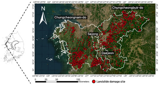
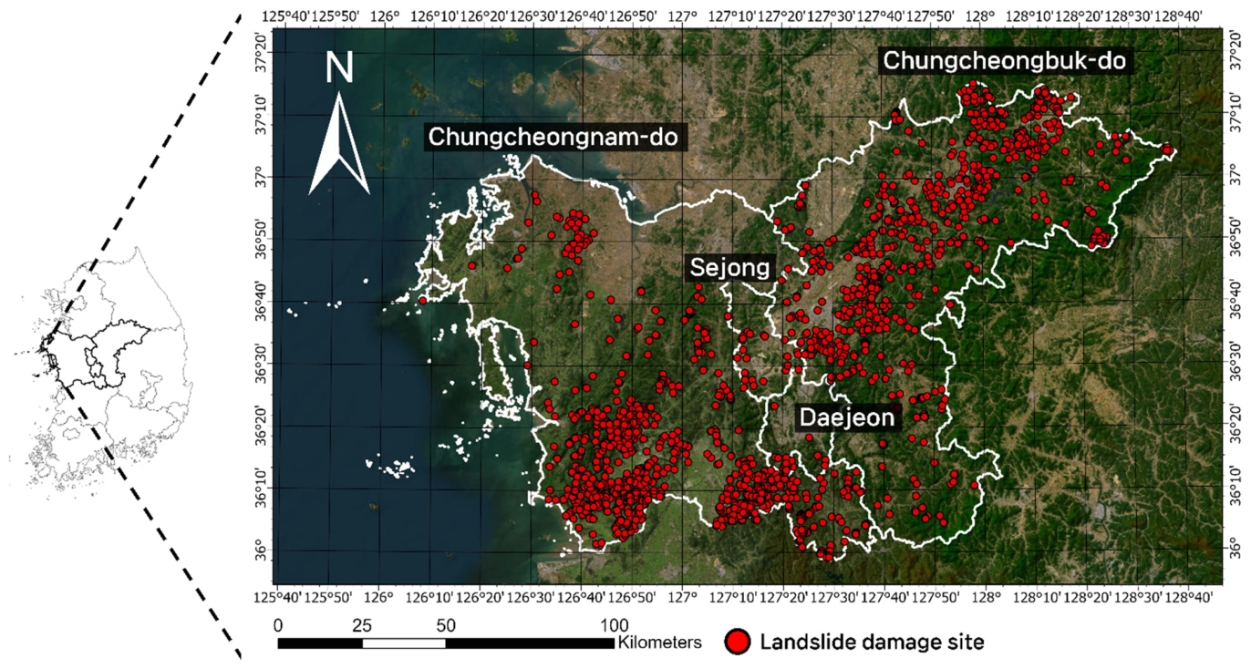
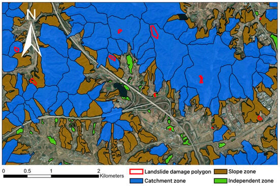
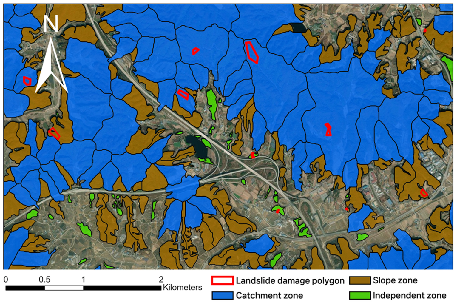
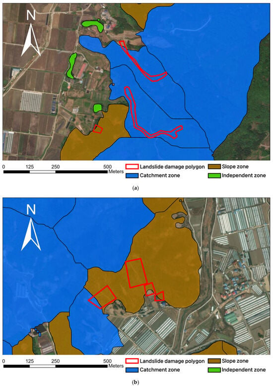
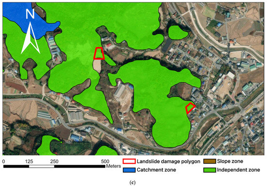
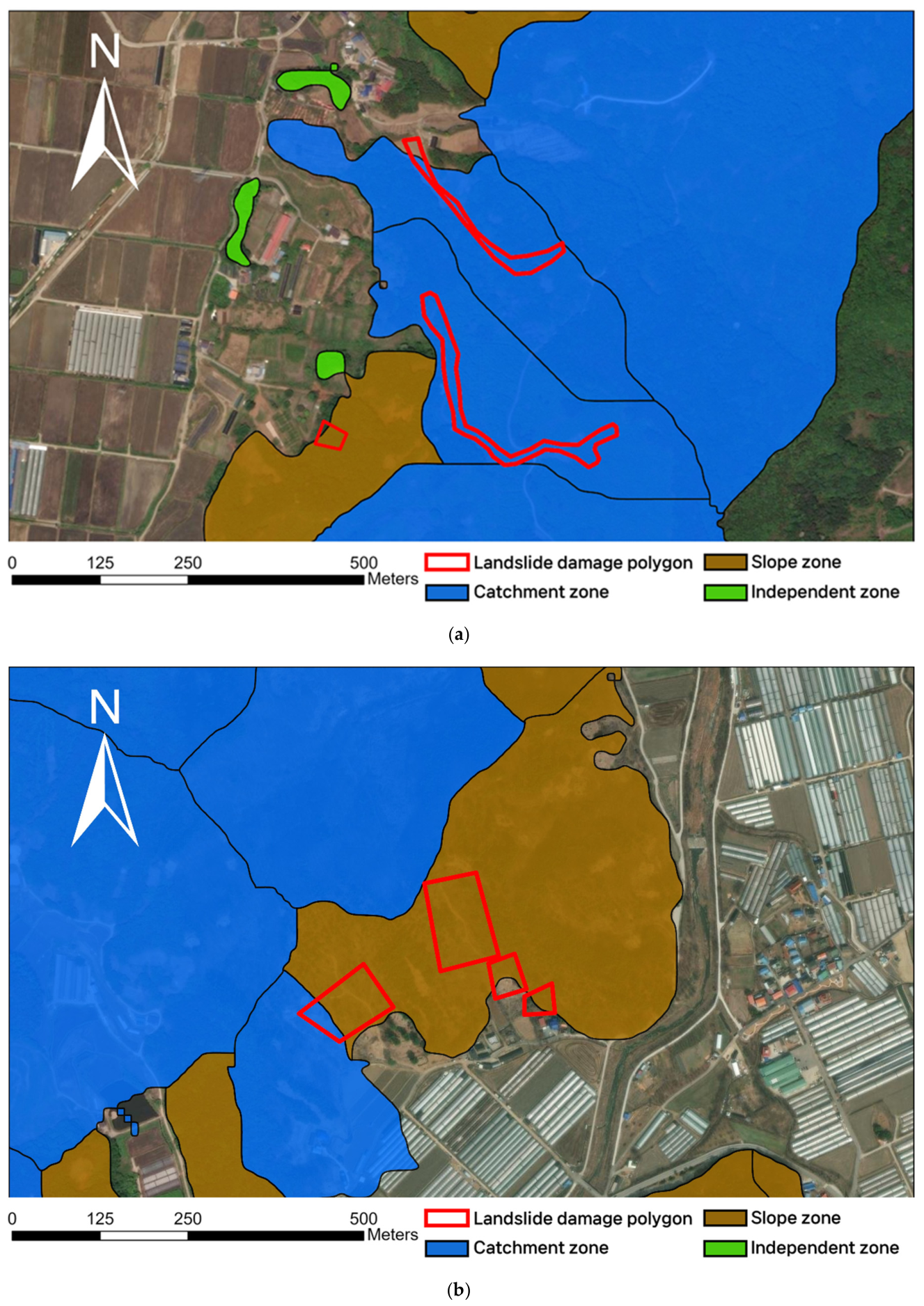
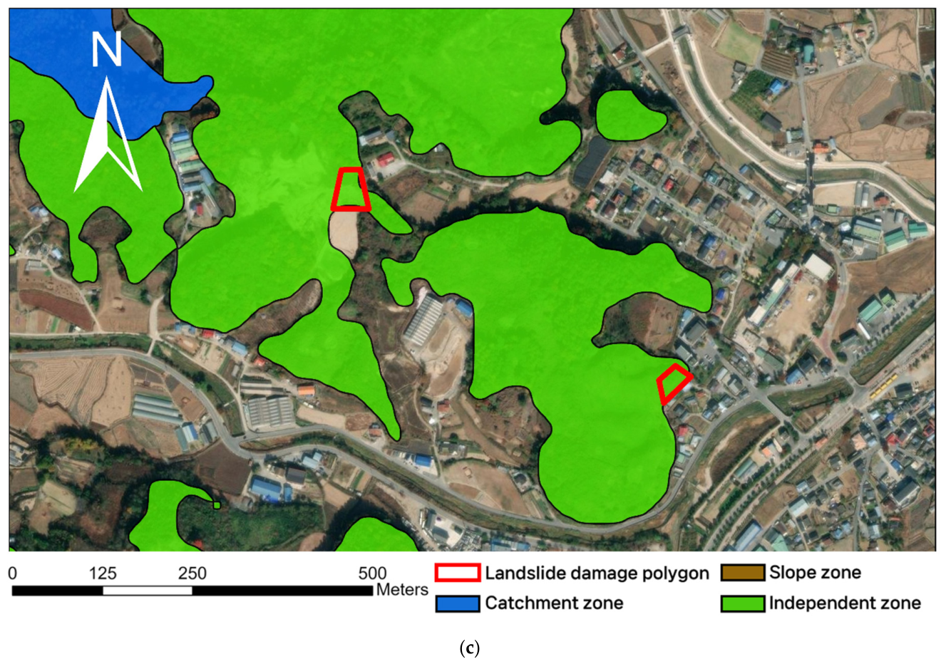
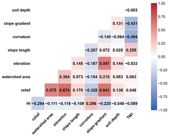
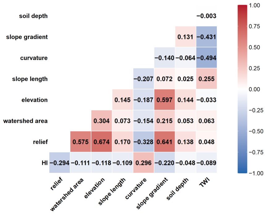
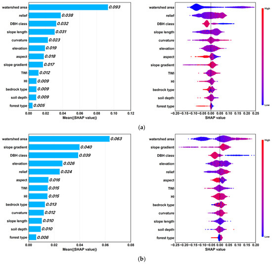
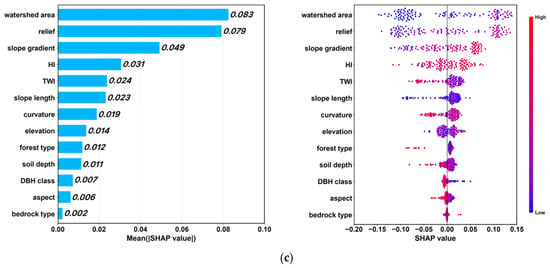
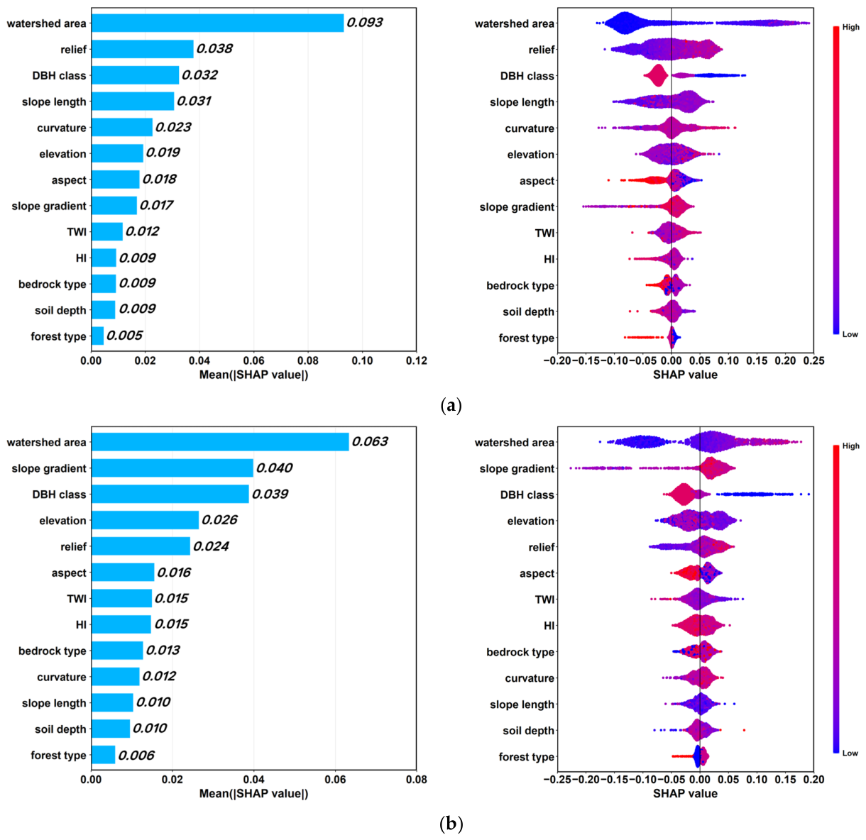
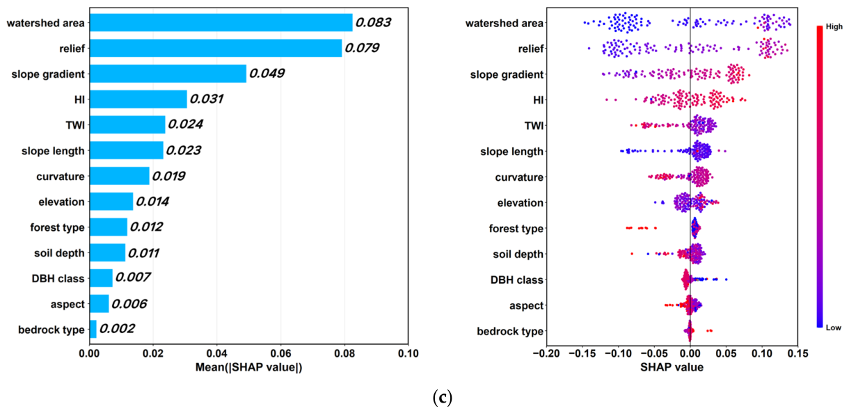
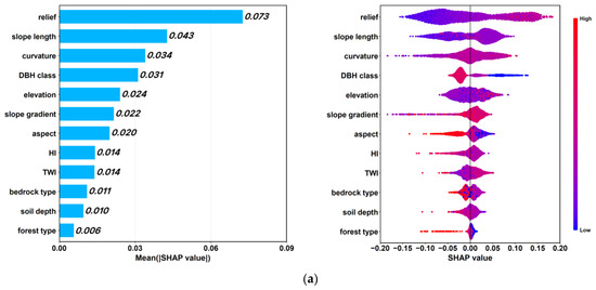
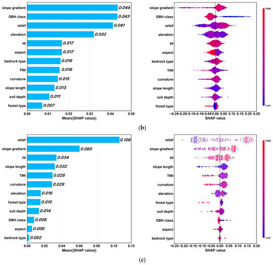
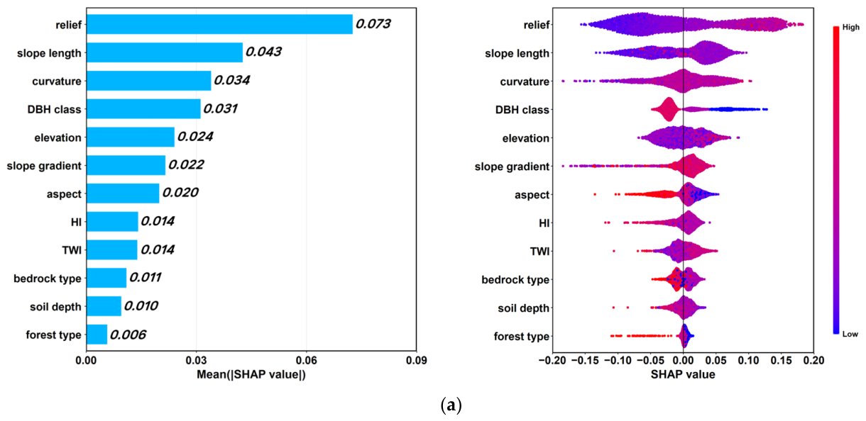
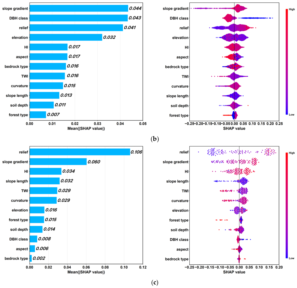
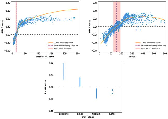
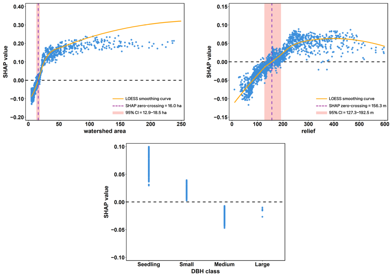
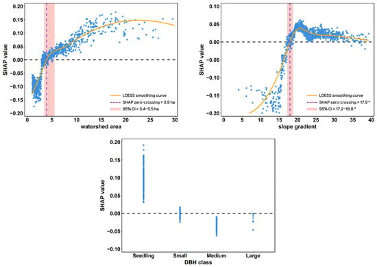
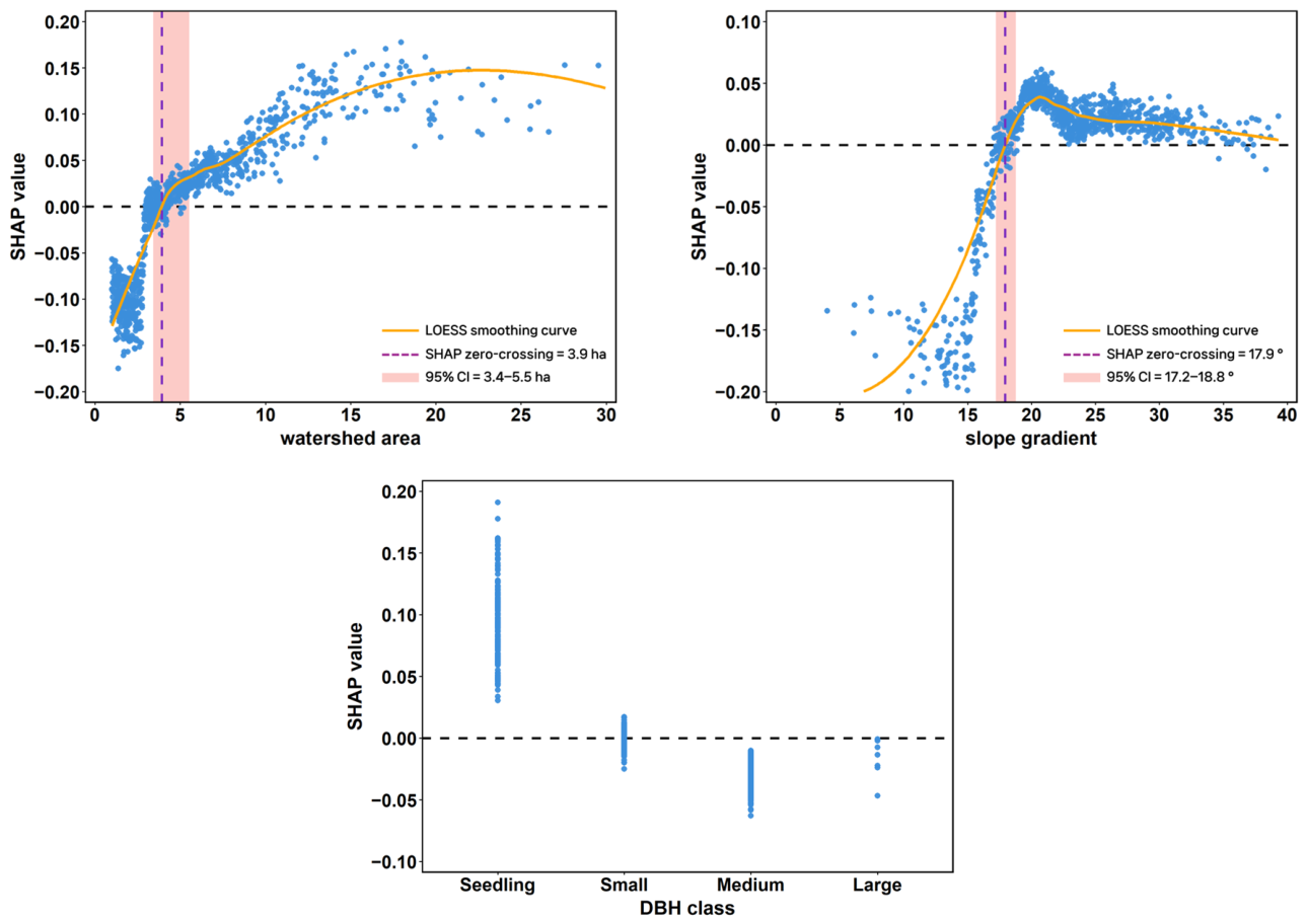
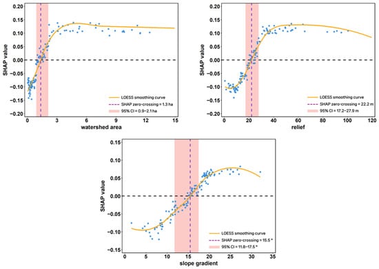
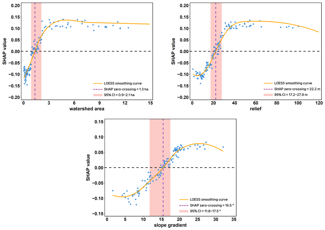

Disclaimer/Publisher’s Note: The statements, opinions and data contained in all publications are solely those of the individual author(s) and contributor(s) and not of MDPI and/or the editor(s). MDPI and/or the editor(s) disclaim responsibility for any injury to people or property resulting from any ideas, methods, instructions or products referred to in the content. |
© 2026 by the authors. Licensee MDPI, Basel, Switzerland. This article is an open access article distributed under the terms and conditions of the Creative Commons Attribution (CC BY) license.