


Abstract
The once-extensive coastal forested wetlands (CFWs) of the Mississippi River Delta (MRD) are declining under the combined pressures of pervasive hydrologic change, unregulated harvesting, relative water level rise (due to the combination of geological subsidence and sea-level rise—SLR), and climate change. We synthesize here over 50 years of research conducted in the MRD to examine the history of the CFWs and their management, their ecosystem functions and services, and the nature, extent, and severity of ongoing changes. Seedling recruitment failure and increasing salinity levels are the most immediate threats to forest persistence, necessitating management that restores hydrologic function and sediment and nutrient supply to allow seedling survival and minimizes saltwater intrusion. Collectively, the evidence indicates that managed inflows can bolster accretion and sustain forest function, and long-term resilience requires hydrologic restoration at landscape scales coupled with site-level actions that secure recruitment and address local degradation trajectories. These include freshwater and sediment introduction, protection from herbivory, and, in some cases, planting. Our research findings have important implications for worldwide CFWs, and tidal freshwater ecosystems in general, which occur mainly in tropical deltas.
1. Introduction
The Mississippi River Delta (MRD) accounts for about 25% of the coastal wetlands and 80% of the total wetland loss in the 48 contiguous states [1]. About 25% of Louisiana coastal wetlands are tidally impacted freshwater coastal forested wetlands (CFWs). At the beginning of the 19th century, there was an estimated 500,000 ha of CFWs in the MRD that was affected by coastal water levels [2]; much more existed farther inland. The CFWs were in the inner part of the MRD, where fresh or very low salinity conditions exist, and many were affected by microtidal water level fluctuations due to a combination of Gulf water level changes, rainfall, and upland runoff. CFWs in the MRD were, and still are, located in two distinctly different environments: systems with high direct riverine input and those that receive riverine input episodically. The latter are affected by both salinity intrusion and increasing water levels and are in the most-inland areas of the interdistributary basins of the MRD. Most CFWs affected by high riverine input occur in the Atchafalaya River Basin (ARB), with smaller areas along the lower Pearl River. Beginning in the mid-19th century and continuing through the 20th century, two major impacts affected these forests—the logging of almost all old-growth CFWs by the 1920s [3] and the dramatic alteration of the hydrology of the MRD due to the leveeing of most of the river and widespread alteration of the surface hydrology of the deltaic plain, occurring mainly after 1930 [4,5].
As noted, nearly all the extensive, previously uncut stands of bald cypress (Taxodium distichum [L.] Rich.) that, historically, extended from northern Louisiana to the northern U.S. Gulf Coast were harvested between 1880 and 1925 [6,7,8]. Outside of Louisiana, one can only find reports of similar CFW areas from Florida’s Big Cypress Swamp [9], South Carolina’s Santee Swamp [10], and Georgia swamps [11].
Over the last half-century, there has been a growing recognition of the ecological value of CFWs. It is now recognized that these lands are widespread, integral parts of the coastal and riverine and coastal ecosystems of which they are part, providing essential habitat, spawning and nursery areas, and food resources for a wide range of organisms, while also contributing substantially to flood mitigation, storm reduction, aquifer recharge, hydrologic processes, and the enhancement of water quality [12,13,14,15,16]. Extensive research has been conducted to evaluate how CFWs respond to the combined interactions of weather, climate, flooding, nutrient input, accretionary dynamics, and salinity in the MRD (e.g., [17,18,19,20]).
In the following sections, we summarize the existing knowledge about Louisiana’s CFWs, including the history of the ecosystem and its management, ecosystem functions and services, and the nature, extent, and severity of ongoing changes. We then outline a strategic framework to guide the effective management and restoration of these critical ecosystems. The findings have broad relevance for CFWs worldwide, which occur mainly in tropical areas, where the impacts of climate change are of particular concern. The high rate of relative sea-level rise (RSLR) due to geological subsidence and sea-level rise, high tropical storm frequency, and changes in freshwater availability due to human activities make the MRD an important case study for understanding coastal ecosystem response to climate change and its interactions with anthropogenic stressors [21].
2. The Mississippi River Delta and the Importance of Coastal Forested Wetlands
The MRD is composed of several interdistributary basins separated by active (the Mississippi and Atchafalaya rivers) and abandoned river distributary ridges ([4,22]; Figure 1). The Delta was formed as the river avulsed into a series of deltaic lobes after the sea level stabilized about 5000–6000 years ago during the mid-Holocene. Substantial portions of these delta lobes and their distributary channels have been incorporated into the modern deltaic plain (Figure 2). At its maximum extent during the 18th and 19th centuries, the delta covered approximately 25,000 km2 of wetlands, inshore water bodies, and low-elevation uplands [22,23,24,25].
Figure 1.
Delta lobes of the MRD with times of active growth (adapted from [26]).
Figure 2.
Map of the distribution of coastal wetlands of the Mississippi Delta.
Our discussion of CFWs includes those that are influenced by water levels in Louisiana’s northern Gulf region. CFWs are the most inland of the series of wetland zones located generally parallel to the coast ([27]; Figure 2). Most CFWs in Louisiana occur in the Atchafalaya, Pontchartrain, Breton, Barataria, and Terrebonne basins. It is important to understand that CFWs in Louisiana are deltaic, and deltas are different in a number of important ways (discussed below) from non-deltaic coastal systems.
The area of CFWs has substantially diminished due to multiple interacting stressors, including logging, reclamation, hydrologic modification including isolation from Mississippi River input, nutrient limitation, and saltwater intrusion. Significant areas of the remaining forested wetland are currently degraded or in decline [2]. Levee construction along the Mississippi River has eliminated the formerly consistent supply of freshwater, nutrients, and sediments, while also facilitating periodic saltwater intrusion from the Gulf of Mexico [21]. The digging of canals, in combination with rising water levels, has further increased both the frequency and severity of saltwater intrusion [28].
Historically, the Atchafalaya River Basin (ARB) was approximately 200 km long, beginning at the confluence of the Mississippi, Red, and Atchafalaya rivers. Prior to 1850, the ARB was a backswamp and had limited connection to the river itself, and it only received significant sediment during large floods [26,29]. Because of this, most of the Basin was open water. In about 1850, the Atchafalaya River was directly connected to the Mississippi River, which led to large increases in sediment input that resulted in the infilling of many channels, lakes, and backswamp areas [30,31,32,33,34]. After the large Mississippi River Flood of 1927, the boundaries of the ARB were changed by the construction of flood protection levees (Figure 3; [35]). These levees constrained the basin into a system of floodways approximately 25 km wide [36]. There is nearly 400,000 ha of CFWs in the ARB, consisting of bottomland hardwood forests (BLH) in the north and transitioning to bald cypress–water tupelo (Nyssa aquatica L.) swamps (CT) mixed with willow (Salix nigra L.) forests in the south (Figure 4; [36,37]). The basin receives inflows from the Mississippi and Red rivers. Levees keep water within the smaller basin confined by levees, while control structures at the upstream end regulate incoming river discharge. The hydrology of different areas of the basin ranges from highly connected riverine locations to backwater areas that are only hydrologically connected during periods of high flow [35].
Figure 3.
The Atchafalaya River Basin in southern Louisiana [35]. Used with permission.
Figure 4.
Frequency of water classification of the nine Landsat images of the Atchafalaya River Basin (modified from [37]).
Prior to building flood control levees along the Mississippi River and other major distributaries, coastal basins received large amounts of river water and suspended sediment input during overbank flooding and crevassing. It is important to understand that much of this input occurred in the most-inland areas of coastal basins, where most CFWs are located. Since levee construction, there has been very little direct riverine input into swamp forests in the four interdistributary basins (Terrebonne, Barataria, Breton, and Pontchartrain) east of the ARB, where most tidally affected CFWs occur. Annual water level fluctuations are generally less than a meter. Because of eustatic SLR and geologic subsidence, the relative water level rise is often greater than 1 cm/yr, which has led to near-permanent flooding in many CFWs, which has led to the lack of seedling recruitment.
By contrast, CFWs in the ARB receive very large inputs of river water and sediments. The annual water level fluctuation can be more than 5 m, and the basin was infilling for most of the 20th century [36]. BLH forests, which cannot tolerate permanent flooding, and agriculture (in cleared BLH areas) dominate the upper basin; however, the lower basin still has large stands of bald cypress–water tupelo forests. The hydrology of all these areas has been dramatically altered by levees and canals (often with associated spoil banks).
As a result of the lack of riverine input due to levee construction and pervasive alteration of the surface hydrology of the MRD, there has been a precipitous loss of CFW areas. Most of the CFWs that still exist outside of the ARB (Figure 5) can persist for many decades in permanently flooded areas [36,37,38]. Increasing salinity can, however, lead to the rapid death of bald cypress, water tupelo, and swamp tupelo (Nyssa biflora Walt.). In general, high river water and sediment input resulted in a transition from open water to CT to BLH. The reduction of river water input reversed this, and now the transition trajectory is BLH to CT to open water. The future of CFWs in this century in the upper interdistributary basins is dependent on preventing saltwater intrusion into these areas and, in the long term, reintroducing mineral sediments to these basins to offset submergence and build elevation.
Figure 5.
The eastern deltaic plain of the Mississippi River Delta, showing projected marsh loss this century. CFWs are concentrated at inland margins of interdistributary basins (named in the figure) and in the river-dominated Atchafalaya Basin (shown in Figure 3 and Figure 4). CFWs are largely maintained relative to widespread marsh loss, though many are expected to decline over longer timescales due to flooding and salinity intrusion. Orange indicates land gained from Coastal Master Plan projects [39].
Crevasses are small-scale depositional features (100–200 km2) that form when large floods overtop the natural levee of the river and deposit small sub-deltas or crevasse splays [40]. These are important for CFWs because the elevation near the river is high enough to support BLH forests and provide high levels of suspended sediments to nourish CFWs dominated by CT. Hundreds of crevasses were formed during the colonial period, but flood control levees progressively reduced overbank flooding and crevasse formation [40,41,42,43,44,45]. Occasional levee failures led to crevasse formation. A notable example was the Caernarvon crevasse below New Orleans that formed when a deliberately created crevasse at Caernarvon during the great 1927 flood remained open for approximately three months and formed a crevasse splay of 130 km2 [44].
For deltaic wetlands to remain self-sustaining, vertical accretion must occur rapidly enough to maintain elevation to counteract high rates of relative sea-level rise (RSLR) due to a combination of geologic subsidence associated with the compaction of unconsolidated sediments and eustatic sea-level rise [46,47,48]. Rates of RSLR vary over relatively short spatial scales across the MRD as a function of local subsidence; however, the RSLR rates were approximately 13.2 mm/yr for the deltaic plain for the period 2006–2020 [49]. On average, subsidence currently accounts for about 85 percent of the total RSLR in the MRD [48], but this proportion is likely to decrease as eustatic SLR grows. These data underscore the critical importance of riverine sediment delivery and organic soil formation from plant growth for maintaining the soil surface elevation in CFWs relative to RSLR.
The management of CFWs is made difficult in part because ownership patterns do not coincide with large-scale hydrological alterations. Much of the CFWs in Louisiana are privately owned, and interest in obtaining economic value from forest products is high. However, forest management is difficult from a policy standpoint because of emerging sustainability issues related to the progressive loss of CRW due to sediment deficits, rising water levels, and saltwater intrusion. These will make managing coastal forests more difficult, and a comprehensive plan is necessary to restore these forests to sustainability. This information underscores the critical importance of riverine sediment delivery for maintaining forest elevation relative to rising water levels.
3. Ecology of Coastal Forested Wetlands
3.1. Productivity Studies in the Barataria and Terrebonne Basins
One of the earliest quantitative studies of CFWs in the MRD took place in the upper Barataria Basin (Figure 6) and quantified differences in tree species composition and aboveground net primary productivity (ANPP) between BLH and CT sites [6]. The less flooded BLH site had 23 tree species compared to nine in the CT site. ANPP was also higher at the BLH site (1574 g/m2/yr vs. 1140 g/m2/yr in the CT site). From this 1976 study and comparison to others that were being conducted at the time [9,50,51], the idea arose that seasonal flooding provided optimal conditions for forested wetland growth in the Mississippi River floodplain in general, and specifically in the CFWs of the MRD, while areas characterized by extended flooding were less productive. It was also apparent from these studies that there was a lack of CT seedling recruitment. Seedlings require moist but not flooded conditions to survive. This was also reported by Montz and Cherubini [52] in another Louisiana swamp forest area. The conclusion at that time was that the heavy rains and resulting high water levels from previous years were preventing seed germination and seedling recruitment.
Figure 6.
Locations of study sites in the Barataria and Terrebonne basins. 1: BLH area [6]; 2: crawfish farm with controlled water levels [53]; 3: flooded area [53]; 4: natural bald cypress–water tupelo area [6,53]; 5: area with BLH ridge, transitional, and flooded study sites [54]. Google Earth Imagery.
In a follow-up investigation conducted in 1978, the reference CT forest examined by Conner and Day in 1976 [6] was evaluated alongside two additional conditions: a site subjected to permanent flooding and a hydrologically managed site [53]. The permanently flooded area in the 1978 paper resulted from impoundment associated with a roadway and drainage infrastructure, whereas the managed site was enclosed by levees and operated under a seasonal hydrologic regime, with inundation during winter and spring followed by summer drawdown to support crawfish (Procambarus clarkii) production. Consistent with the earlier work of Conner and Day [6], bald cypress and water tupelo dominated the natural site, accounting for more than 70% of the total stem density and approximately 94% of the basal area (BA), with an overall tree density of 1303 trees/ha between 1976 and 1978.
At the managed crawfish site, periodic water drawdown facilitated seed germination and seedling establishment. Red maple (Acer rubrum L.) and ash (Fraxinus spp.) were the most frequently encountered species, although together they comprised only about 39% of the total BA. Baldcypress and water tupelo were the largest individuals at this site, contributing nearly half of the BA. The permanently flooded site supported the lowest tree density (943 trees/ha) and BA overall. While bald cypress and water tupelo accounted for roughly 63% of the BA, buttonbush (Cephalanthus occidentalis L.) and red maple occurred at the highest stem densities. Although ash contributed substantially to the BA at this site, many individuals exhibited dead or declining crowns by the end of the study. This permanently flooded area also supported several species absent from the other sites, which reflects the presence of small remnant natural levees that remained emergent following impoundment. Species such as oak (Quercus spp.), hawthorn (Crataegus spp.), and wax myrtle (Morella cerifera (L.) Small) and other bottomland hardwoods were observed on these elevated features. Overall, the vegetation patterns documented in the Barataria Basin are broadly representative of CFWs in the MRD.
At the naturally flooded site, stem production and litterfall from CT accounted for nearly all aboveground production, totaling approximately 1166 g/m2/yr in 1978 [53], a value essentially unchanged from the estimates reported for 1974 [6]. By contrast, ANPP at the permanently flooded site was lower, at 886 g/m2/yr. Although individual bald cypress and water tupelo trees exhibited relatively high stem growth rates under permanent flooding, their low stand densities reduced overall areal productivity. As a result, a substantial share of the total production at this site was contributed by buttonbush, maple, and snowbell (Styrax americanus), which were increasing in dominance.
Productivity was highest at the crawfish farm, where seasonal inundation and continuous inflow of nutrient-rich water during flooded periods supported elevated growth rates. Tree ANPP at this site reached 1780 g/m2/yr. The mean annual litterfall from 1977 to 1981 was highest in the crawfish pond (579 g/m2/yr), lower in the naturally flooded forest (405 g/m2/yr), and lowest under permanent flooding (293 g m−2 yr−1). Litterfall declined progressively during the first four years of monitoring, a pattern attributed to chronic flooding and associated tree mortality. In 1981, litterfall increased across all sites, likely reflecting drought conditions that allowed soils to dry for the first time in many years and temporarily improved growing conditions.
Between 1987 and 1989, substantial reductions in tree density were documented at both the impounded site (from 480 to 160 trees/ha) and the crawfish farm (from 1030 to 620 trees/ha), whereas declines at the naturally flooded site were comparatively modest (from 990 to 880 trees/ha) [55]. Losses occurred across all size classes, with the greatest reductions in the 10 and 20 cm diameter classes, and mortality was dominated by red maple and ash. A subsequent survey conducted 20 years later in 2009 (Conner, unpublished data) indicated renewed increases in tree density at the impounded and crawfish farm sites (670 and 260 trees/ha, respectively), driven primarily by the recruitment of red maple, ash, and buttonbush. By contrast, tree density at the naturally flooded site continued to decline, reaching approximately 830 trees/ha.
In the Verret Basin, a former overflow area in the Terrebonne Basin between the Mississippi and Atchafalaya rivers and west of the Barataria Basin, ANPP and species composition across an elevation/flood gradient were examined from 1985 to 1986 to quantify changes occurring in this area with rapidly rising water levels [54]. Water levels were rising over 1 cm/yr [17] in the area, subjecting CFWs to longer and deeper flooding. There was a clear trend in ANPP, with the ridge area > transitional area > flooded area. Forest stands in the area developed when flooding patterns were considerably different than they were at the time of study and sedimentation from annual floods was still occurring. Waterlogging stress was clearly observed, as indicated by the presence of dead and dying trees, and continued long-term increases in water levels are expected to favor the establishment of flood-tolerant species, ultimately leading to the loss of these forested wetlands within approximately two centuries [56]. Continued measurements of annual tree growth in the area from 1986 to 2009 indicated that the two communities (a mesic forest dominated by sugarberry [Celtis laevigata Willd.], oak, and ash and a hydric forest dominated by red maple, ash, and bald cypress) present in the 1980s had evolved into four community types by 2009 [57]. Following Hurricane Andrew in 1992, a substantial shift in species composition was observed at the drier sites with the establishment of an invasive species, the Chinese tallow (Triadica sebifera (L.) Small). Low-lying and transitional zones are progressively shifting from bottomland hardwood communities toward deeper-water swamp conditions dominated by bald cypress and water tupelo. Continued increases in inundation in the late 1980s inhibited tree regeneration, as most seeds fail to germinate in standing water, which results in declining tree densities as mature individuals die without replacement [56].
The findings from these studies underscore the progressive challenges facing CFWs in the MRD. Prolonged inundation is associated with increased tree mortality and reduced forest productivity. Across the MRD, RSLR is occurring at an average rate of approximately 1 m per century [24], resulting in longer and deeper flooding of CFWs driven largely by human-induced sediment deficits [17]. In areas where hydrology remains relatively unaltered, annual tree mortality rates are typically low, on the order of 2% yr−1 [55]. However, severe hydrologic modification arising from natural processes (subsidence and sea-level rise) and human impacts (dredging and levee construction) represents a major stressor to these systems.
Conner et al. [55] documented a marked increase in annual tree mortality in the CFWs of South Carolina and Louisiana, which rose from approximately 4% in 1987 to 16% in 1997 as water levels increased. Less-flood-tolerant species were eliminated, which left primarily bald cypress, water tupelo, and red maple. Even among surviving red maple individuals, pronounced stress was evident, including crown dieback and branch mortality, suggesting the eventual loss of this species as well. Given the limited opportunities for natural regeneration under sustained flooding, these sites will likely transition to herbaceous wetlands or open water following the eventual mortality of existing bald cypress and water tupelo stands [56]. In addition, disturbed areas are vulnerable to colonization by invasive species, like Chinese tallow, which has demonstrated the capacity to dominate the canopy, as observed in the Verret Basin following Hurricane Andrew [57].
With an increased emphasis on CFWs across the southeastern U.S., more studies were published and made available for comparison. Mitsch and Ewel [58] concluded that forest productivity was higher with fluctuating hydrologic conditions compared to consistently dry or wet conditions, but increased flooding in the MRD is causing lower NAPP (Figure 7A). Mitsch et al. [59] also observed a positive relationship between river discharge and growth of bald cypress (Figure 7B). Similarly, when the ANPP of wetland sites was ranked as flooded—stagnant, flooded—slowly flowing, flooded seasonally, or drained, Conner and Day [60] observed that optimal ANPP occurred at sites with seasonal flooding (Figure 7C). However, Megonigal et al. [61] demonstrated that periodic inundation and flowing water do not consistently result in higher productivity relative to upland forests (Figure 7D). By contrast, prolonged flooding almost invariably imposes substantial constraints on forest productivity, particularly where hydrologic regimes have been recently altered by levee construction or impoundment. Although ANPP on wet plots declined with increasing mean water depth at a rate of −5 g/m2/yr/cm, sites exhibiting clear hydrologic disturbance (>25% dead stems) showed a slope approximately five times steeper (−24 g/m2/yr/cm) [61]. In summary, rising water levels, salinity intrusion, and hydrological alteration have led to the declining health of CFWs, similar to that of coastal marshes and mangroves [62,63].
Figure 7.
Relationship between forest productivity and hydrology based on different studies in the southeastern United States. Panel (A) from Mitsch and Ewel [58]; Panel (B) from Mitsch et al. [59], used with permission from John Wiley and Sons; Panel (C) from Conner and Day [60]; Panel (D) from Megonigal et al. [61], used with permission from John Wiley and Sons.
3.2. Long-Term Tree Growth—Dendrochronology Analysis
Dendrochronological analysis of bald cypress was carried out at five sites in the MRD, providing insights into how a variety of environmental factors impact long-term growth patterns. These sites include three assimilation wetlands where nutrient-rich treated municipal effluent has been introduced for multiple decades; a permanently flooded CFW that is isolated from river input and impacted by periodic salinity intrusion; and the Bonnet Carré Spillway, which receives very large but infrequent inputs of Mississippi River water. Taken together, these sites experience the full range of impacts on CFWs in the MRD.
3.2.1. Breaux Bridge—75 Years of Nutrient Addition
Hesse et al. [64] examined the long-term influence of treated municipal effluent discharge on bald cypress growth at this site characterized by mature bald cypress stands. Treated municipal effluent has continuously been discharged into this wetland at a nutrient loading rate of ~5 g N/m2/yr since the late 1940s. Permanent nutrient retention occurs via denitrification, tree growth, and burial. The effluent spreads out over the swamp floor in wide, shallow channels. Tree ring growth from 1920 to 1992 was measured using cross-dated tree cores collected from reference and treatment sites, using trees of similar age and size. Clear growth differences between sites revealed a sustained growth enhancement in trees at the site with treated effluent following the onset of effluent discharge. The response was variable from year to year, reflecting other factors such as climate variability, but the treatment area always (except for 2 years) had higher growth rates than the reference areas once application began (Figure 8).
Figure 8.
Annual diameter increment ratios of bald cypress from control and treatment sites at the Breaux Bridge assimilation wetland. Effluent discharge began around 1950. Annual diameter increments were always lower for trees in the treatment wetland prior to discharge and were almost always higher after discharge began. There was considerable year-to-year variability. Unpublished data from John Day.
3.2.2. Thibodaux—Prolonged Flooding Versus Nutrient Enrichment
Keim et al. [65] assessed the interactive effects of prolonged flooding associated with rising water levels and nutrient inputs (as at Breaux Bridge) on bald cypress growth at a wetland receiving municipal effluent from the City of Thibodaux (Figure 9). Trees at the discharge location, the outflow area, and a nearby reference site experienced increased growth during a period of rapid water level rise in the late 1960s, when bottomland hardwood species declined due to permanent flooding, which resulted in a more open canopy and increased light availability within the subcanopy. Growth at both the discharge and outflow locations started to decline prior to the beginning of effluent discharge in 1992, likely because these sites were approximately 10–15 cm lower in elevation than the reference area. Growth at the effluent site itself showed no detectable response to effluent addition. By contrast, the reference site trees have not yet shown similar reductions in growth due to higher elevation. These patterns indicate that hydrologic alterations driven by subsidence outweighed nutrient input in terms of their effect on bald cypress growth. Initial increases in inundation promoted growth by reducing competition from the mortality of bottomland hardwood species, which are less tolerant of sustained flooding; however, following roughly a decade of continuous inundation, growth rates declined. Competitive release of bald cypress continues at the higher-elevation reference site, although growth there is also expected to decrease due to increasing relative sea-level rise (RSLR) leading to longer-duration flooding. Overall, the results suggest that short-term increases in water levels and nutrient availability enhanced bald cypress growth, whereas long-term permanent flooding acted as a dominant stressor and exerted greater control on growth than nutrient limitation at the treatment site. As flooding duration continues to increase, both the reference and treatment sites are expected to experience declining growth rates, although these forests are likely to persist for decades in the absence of additional stressors such as salinity intrusion.
Figure 9.
Tree ring patterns at the Thibodaux wetland assimilation system at discharge, control, and outflow sites. The vertical gray line is 1992, when effluent addition began. RCS—Regional Curve Standardization method. Modified based on data from Keim et al. [65].
3.2.3. Hammond—Nutrient Enrichment
In 2006, nutrient input due to the input of municipal effluent began at a freshwater marsh and CFW at the Hammond site. Downstream of the marsh area, the site was a CFW dominated by bald cypress and water tupelo. This area was sampled [66] using an increment borer on nine resident bald cypress trees in the assimilation zone. Despite the small sample size, error was estimated to be minimal for the following reasons:
- The same trees were sampled, pre- and post-effluent assimilation. Because effluent application started in November 2006, bald cypress growth prior to that date can be ascribed to a post-logging, nutrient-limited environment which limits tree survival.
- It would have been extremely difficult for the trees to suddenly change growth rates in the absence of environmental stimuli.
- Because the oldest tree rings go back to about 1862, there is a much larger dataset for pre-effluent application. However, there is a cumulative error as you count back in time, due to false tree rings. Because over 90% of the tree ring data was pre-effluent applications, which represent over 90% of the dataset, the tree ring error was deemed acceptable.
Tree cores were mounted according to Stoke and Smiley [67] and Fritts [68], and ring widths were measured. The results indicate that tree growth increased almost 1.9× once nutrients and freshwater were available (Figure 10).
Figure 10.
Annual growth rates of bald cypress trees at the Hammond MID sampling location, 1986–2018 (different color symbols refer to individual trees) [66]. Used by permission of the author.
3.2.4. LaBranche and Bonnet Carré—Cypress Growth with and Without River Input
Day et al. [69] examined bald cypress radial growth patterns in the LaBranche (LB) wetlands and the adjacent Bonnet Carré (BC) Spillway. Although both locations lie adjacent to the Mississippi River, the LB wetlands have not received input of river water since levees were constructed in the nineteenth century. By contrast, the BC wetlands experienced frequent overbank flooding during the second half of the nineteenth century through the Bonnet Carré crevasse, which delivered substantial sediment loads to the area [44]. Following the very large river flood of 1927, the BC Spillway was constructed in 1933 as a flood control outlet designed to divert river water to Lake Pontchartrain and protect New Orleans. Since its completion, the spillway has been operated 11 times, with peak discharges ranging from approximately 3000 to 9000 m3/s, which has resulted in high rates of sediment deposition [69]. Both areas were logged between roughly 1880 and 1920, and most of the tree cores analyzed represent post-logging regrowth. Annual ring widths at the BC sites averaged approximately 2.3 mm/yr, compared to about 1.3 mm/yr for the LB wetlands. Despite similar tree ages, the mean tree height at the LB sites was roughly 20% lower than that at the BC sites.
Among environmental drivers, salinity levels in Lake Pontchartrain showed the strongest correlation with tree ring chronologies. Warm, dry spring conditions were linked to reduced growth, whereas cooler, wetter springs promoted increased growth. The May Palmer Drought Severity Index (PDSI) exhibited the strongest individual climatic relationship with ring-width variation. Although it may seem counterintuitive, the enhanced growth of wetland trees under wetter conditions has been documented for bald cypress elsewhere in Louisiana [70], as well as in North Carolina [71], Arkansas [72], and Mississippi. This response is attributed to increased oxygen availability in the root and vadose zones under flowing or refreshed water conditions [73], compared to stagnant flooding [74], and, potentially, to increased nutrient inputs associated with nonpoint source runoff [20].
Years when the BC Spillway was open—1937, 1945, 1950, 1973, 1975, 1979, 1983, 1997, and 2008—had enhanced growth in both areas (Figure 11). Spillway operations generally occurred during wetter climatic periods. Freshwater inputs from both rainfall and the spillway discharge reduce the input of saltwater, while sediment deposition during spillway openings helps offset subsidence. As a result, the BC wetlands are less vulnerable to prolonged salinity exposure and generally exhibit more effective drainage than the LB wetlands. Even when hurricane storm surges introduce saline water into the BC system, higher elevations and freshwater flushing appear to limit long-term high salinity. A concurrence of dry springs, extended drought, and hurricane impacts resulted in an extended period of suppressed growth during the 1960s and early 1970s in both areas.
Figure 11.
Ring widths (upper) and ARSTAN chronologies (lower) for bald cypress at LB and BC sites. Each point is the mean across sampling locations. Vertical shaded bars are years when the Bonnet Carré Spillway was open [69]. Modified based on data from Keim et al. [65].
Long-term tree ring chronologies developed across all study sites provide critical insight into the cumulative effects of subsidence, increased inundation [70,75], nutrient enrichment, and salinity stress on forested wetlands and offer a means to evaluate the potential long-term consequences of river diversion projects [16,69]. Subsidence promotes longer-duration flooding, and when saline waters are present, saltwater intrusion is more likely. Nutrient inputs can enhance bald cypress growth, and growth is also favored during periods when soils periodically dry. These latter conditions were observed at the Breaux Bridge and Bonnet Carré sites [64,69].
The degradation of bald cypress–water tupelo forests with and without riverine input reflects a broader regional pattern rather than an isolated case within coastal Louisiana. The documented declines extend from the margins of lakes Pontchartrain and Maurepas into interior swamp systems [19]. Over the past 100–200 years, reduced freshwater delivery following levee construction, combined with diminished sediment and nutrient inputs, has led to widespread reductions in tree growth and, in some areas, the complete loss of CFWs. For instance, extensive portions of the CFWs in the Pontchartrain Basin transitioned largely to marsh and open-water habitats [76].
In summary, these five sites represent the range of long-term environmental conditions experienced by CFWs in the MRD. Nutrient addition without water level rise enhances ANPP. Reduction in river input leads to a reduction in freshwater, sediment, and nutrient input, which leads to lower ANPP, rising water levels, and saltwater intrusion. Long-term water level rise offsets the positive effect of nutrient input.
4. Water Quality Dynamics in CFWs
CFWs in the MRD exert a strong influence on nutrient cycling and water quality, particularly in areas where riverine inputs enter coastal environments (Figure 12). In the upper Barataria Basin, the trophic state index of waterways was closely linked to the density of drainage channels. Natural channels characterized by lower-drainage-density natural waterways had much better water quality than areas with higher drainage density, which were impacted by agricultural drainage. In channelized systems, the inorganic N:P ratio responded strongly to rainfall during the preceding five-day period, whereas flows routed across wetlands showed little sensitivity to recent precipitation. These findings indicate that restoring over-wetland flow pathways in CFWs is critical for maintaining improved water quality. Nitrate–salinity mixing relationships for waters entering coastal water bodies with extensive CFWs have improved water quality, reflecting the strong net removal of NO3, largely through denitrification. Numerous studies across the MRD demonstrate that shallow, wetland-dominated systems are highly effective at nutrient removal, support good water quality, and promote ecosystem productivity [47,77,78,79,80,81,82].
Figure 12.
Indicators of water quality in CFWs of the MRD CFWs. Upper left: the relationship between drainage density and trophic state index in CFWs of the upper Barataria Basin. Lower values for TSI have better water quality [83]. Right: N:P ratio in (A) channelized streams versus (B) flow through wetlands in the upper Barataria Basin [84]. Lower left: nitrate–salinity mixing diagrams for the Barataria Basin [85] and the upper Breton Sound affected by diversions of Mississippi River water [86]. Figure from Day et al. [16]. Used with permission from the International Society for Ecological Modelling.
Assimilation wetlands are naturally occurring but hydrologically altered wetlands that receive treated municipal effluent, with the combined objectives of enhancing water quality and vegetation health and promoting soil accretion to offset RSLR [86,87,88,89]. Wetlands enhance water quality by removing contaminants, sediments, and nutrients from surface waters through a combination of physical and biogeochemical processes and biological pathways including burial, incorporation into plant biomass, and denitrification [90,91,92,93]. Data from five assimilation wetlands in Louisiana are summarized below. These systems are dominated by CFWs.
Total nitrogen (TN) loading rates range from 0.83 to 7.55 g/m2/yr, while total phosphorus (TP) loading rates range from 0.23 to 2.87 g/m2/yr (Table 1). The variation in loading rate is due mainly to the area of receiving wetlands rather than to nutrient concentrations. These values are well below the loading limit of the Louisiana Department of Environmental Quality, which is 15 g N/m2/yr and 4 g P/m2/yr, respectively. Long-term monitoring indicates that assimilation wetlands continue to retain nutrients even after decades, with concentrations of both TN and TP generally reduced to background levels [89].
Table 1.
Characteristics, nutrient loading, and % nutrient removal at forested assimilation wetlands in Louisiana.
Across the five wetlands in Table 1, the mean accretion at near sites (those closest to treated effluent discharge) averaged 1.37 ± 0.06 cm/yr (mean ± SE), compared to 0.60 ± 0.02 cm/yr at reference areas. These results indicate that wetlands receiving treated effluent are accreting at rates that exceed the average subsidence rate of the Mississippi River deltaic plain (approximately 0.9 cm/yr). Accretion rates differ among sites as a function of nutrient and sediment inputs [89].
The discharge of treated municipal effluent to wetlands provides nutrients and sediments that enhance vegetative ANPP [90,91]. CFWs in the MRD have functioned as nutrient-rich ecosystems due to river water input, but most CFWs are isolated from historic inputs of river water due to hydrologic alterations [20,92]. In some of the assimilation wetlands, treated municipal effluent enhances ANPP compared to the reference wetlands [93]. The productivity values are typical for freshwater forested wetlands in the Mississippi Delta.
5. Ecosystem Functions and Human Impacts of Coastal Forested Wetlands
CFWs of the MRD are dominated by forests of bald cypress and water tupelo. Pond cypress (T. ascendens Brongn.) and swamp tupelo are common associates in these wetlands, but they are mainly absent in this area except near the northeastern margins of the delta. Bald cypress and water tupelo can live for centuries and can survive long-term flooding. However, continuous inundation by stagnant water during the growing season can lead to lower productivity and eventual mortality [94,95]. Thus, CFWs that experience prolonged flooding can persist for long periods of time, but often in an increasingly degraded state.
The recruitment of new individuals is a fundamental process in the ecology of CFWs. Seeds of bald cypress and water tupelo are unable to germinate under flooded conditions [96,97]. In controlled laboratory settings, bald cypress seedlings bearing foliage can tolerate complete inundation for up to 45 days [98], although field observations suggest that tolerance durations are typically shorter. During the first growing season, seedlings commonly attain heights of approximately 20–75 cm [99,100,101], which lowers the likelihood of submergence during periods of active growth. Flooding during dormancy generally has a minimal impact on seedlings, and spring inundation may delay emergence from dormancy; however, flooding later in the growing season can result in complete seedling mortality [102]. Inundation beneath the developing seedling canopy can reduce competition from less-flood-tolerant species. Historical old-growth stands often consisted of multiple even-aged cohorts established during low-water periods associated with drought [99], yet regeneration is typically limited where dense canopies restrict light availability at the forest floor or where persistent standing water occurs [103].
Three major herbivores play important roles in swamp forest dynamics by influencing regeneration. Nutria (Myocastor coypus), established widely in coastal Louisiana since the 1950s [104], clip or uproot bald cypress seedlings and can severely constrain local regeneration. Recurrent and extensive defoliation of water tupelo by the forest tent caterpillar (Malacosoma disstria Hubner), affecting areas as high as 250,000 ha, has been documented in Louisiana since 1948 [105]. The bald cypress leafroller (Archips goyerana Kruse), first reported in coastal Louisiana in 1983, reduces overstory productivity by suppressing growth and inducing crown dieback [106]. Trees in the lower canopy are more vulnerable to caterpillar herbivory due to larvae falling from taller trees [18], which further limits the survival and recruitment of younger stems.
The salinization of wetlands is expected to increase as a result of climate change and anthropogenic changes to hydrological cycles [107]. Saltwater intrusion exacerbates flooding stress, which lowers productivity and can result in mortality for bald cypress and water tupelo [18,106,108]. Bald cypress tolerates salinity up to 8 parts per thousand (ppt) for short time periods, but productivity and survival decline above 4 ppt [109,110]. Chronic soil salinity of 2 ppt at root depth reduces the annual ring growth of bald cypress [80]. Research from CFWs in North Carolina further suggests that, along estuarine gradients, the transition from forested wetland to marsh occurs where adjacent wetlands are exposed to salinities exceeding 1 ppt for more than approximately 12% but less than 25% of the time [111]. Salinity can also reduce germination [112] and seedling growth [18,106].
Bald cypress trees exposed to saline water also experience reduced diurnal transpiration [113]. Transpiration is an inevitable consequence of carbon uptake for photosynthesis, so the consistent effect of salinity on bald cypress transpiration, productivity, and survival is expected. However, transpiration can be measured on sub-daily timescales for whole trees using sap flux sensors, which is a useful measurement for detecting environmental impacts on tree physiological status. Schexnayder and Wolfe [114] compared transpiration in bald cypress trees that received nutrient addition in the Hammond Assimilation Wetland to trees in an adjacent stand in the Joyce Wildlife Management Area that did not receive nutrient addition. Nutrient addition was associated with an increase in whole-tree transpiration of 5.8 L/day. However, among trees, the sensitivity of transpiration to atmospheric vapor pressure deficit was positively related to leaf nutrient content. These results suggest that when the air temperature is higher and the relative humidity is lower, trees that receive nutrient addition experience greater reductions in transpiration—and by association, productivity—than trees that do not receive nutrient addition. Considering that the air temperature is expected to continue increasing this century, the growth enhancement that bald cypress trees generally experience in assimilation wetlands (see Section 3.2) may be reduced. Schexnayder and Wolfe used tree ring analysis to compare growth in relatively young trees between the Hammond site and the Joyce Wildlife Management Area 1.5 km to the southwest, which served as a control site that did not receive nutrient input. There was no difference in basal area increase for 14 trees with DBH (diameter at breast height) ranging from 13.5 to 27.2 cm between 2012 and 2017. However, from 2018 to 2022, the basal area increment was two times greater at the Hammond versus the control site, supporting the results in the longer timeseries discussed earlier.
6. Ecosystem Services of Coastal Forested Wetlands
CFWs provide multiple economic, ecological, cultural, and recreational ecosystem services, including wildlife habitats, flood protection, water quality improvement, tropical storm protection, carbon sequestration, timber production, and commercial fisheries [115].
The position of CFWs within the landscape, together with their biogeochemical characteristics, provides both the capacity and pathways to influence pollutant inputs to downstream aquatic systems [84,116]. Forested wetlands of the lower Mississippi Alluvial Valley generally exhibit high rates of denitrification [117,118,119]. Elevated nutrients delivered by the Mississippi River have caused extensive hypoxia in the northern Gulf of Mexico [120]. Nitrogen removal, therefore, represents a particularly critical ecosystem service within the MRD, even though most CFWs are currently disconnected from direct riverine inputs, with the notable exception of the ARB, which carries about 30% of the Mississippi River discharge to the Gulf. Forested wetlands located within the levees of the Atchafalaya Basin substantially reduce the nitrogen load transported from the Mississippi River [121]. Enhancing hydrologic connectivity in other regions of the MRD would expand this function across a broader spatial extent.
Floodplain wetlands reduce the severity of riverine floods downstream by reducing flow volumes and increasing the residence time of stormwater within the watershed [122]. However, there has been little research quantifying the historical or current effects of deltaic CFWs on flooding within the delta. Their effects on riverine flooding are not well understood because there is little occupied land downstream of these forests and because levees interrupt floodwaters.
More importantly, the interactions between CFWs and coastal flooding associated with tropical cyclones remain poorly understood. Evidence from coastal mangrove systems indicates that these forests reduced inland flooding and infrastructure damage during the 2004 Asian Ocean tsunami [123,124]. However, the applicability of these findings to tropical cyclone–CFW interactions in Louisiana is uncertain, given substantial differences in forest structure and the fact that storm surges in the region are primarily wind-driven. Bald cypress is among the most wind-resistant tree species in coastal Louisiana [125], a characteristic that enhances its suitability for coastal protection.
Although wetlands occupy only about 4% of the Earth’s terrestrial surface, they contain nearly one-third of the global soil organic carbon, representing the highest soil carbon pool worldwide [126]. CFWs within the MRD, therefore, serve as a significant reservoir of organic carbon. Elevated ANPP in CFWs, coupled with reduced decomposition rates under anaerobic conditions, leads to soil carbon densities of about 809 tons/ha in wetland forests compared to roughly 90 metric tons per ha in upland forests [127]. This disproportionate capacity for carbon storage, together with the underlying biogeochemical processes governing organic carbon cycling, underscores the importance of wetlands in the context of climate change, greenhouse gas dynamics, and carbon sequestration.
Deltaic CWFs are of international importance for their role in supporting migratory bird species. These wetlands frequently represent the greatest remaining areas of forest along the Gulf Coast and serve as the initial and final terrestrial habitat for trans-Gulf migratory songbirds during seasonal movements. Consequently, they support millions of individuals, encompassing nearly all eastern U.S. land bird species as well as numerous species originating from the western United States [128]. In addition, several dozen migratory songbird species use CFWs as breeding habitats; however, Zoller [129] reported reduced breeding activity in forests that had been degraded by hydrologic alteration. These forests also contain many of the bald eagle nests in Louisiana.
Beyond avian communities, the structural characteristics of CFWs are essential for sustaining other wildlife populations. Two species of bats classified as federal species of concern, the southeastern bat (Myotis austroriparius) and Rafinesque’s big-eared bat (Corynorhinus rafinesquii), as well as the threatened Louisiana black bear (Ursus americanus luteolus), rely on large, hollow bald cypress and water tupelo trees for roosting, hibernation, and nesting [130,131,132].
7. Forest Management and Restoration
7.1. Forest Management
Nearly pure stands of bald cypress occupied CFWs when European settlers first arrived [99]. Commercial logging expanded rapidly between 1890 and 1925 and continued until the final large-scale bald cypress logging operation ceased in 1956 [8]. At the height of this activity, little attention was given to the long-term condition or recovery of harvested wetlands. Management perspectives were largely oriented toward land conversion to other uses, and many logging operations favored removing all merchantable bald cypress, with no intent of retaining trees to support future forest regeneration or return.
The period of lumbering predated the complete regulation of the Mississippi River and the subsequent rapid hydrological changes in CFWs, so most areas regenerated naturally. Forest Inventory and Analysis (FIA) information from the U.S. Forest Service demonstrates that the volume of bald cypress in coastal wetland forests increased following the initial logging until the 1980s but has remained nearly unchanged since then [2]. By the 1980s, second-growth forests began to be composed of trees large enough to be attractive for commercial lumber production again [100], and there has been a resurgence of logging in the CFWs. Unfortunately, this logging pressure comes at a time when productivity has substantially decreased because of hydrologic changes. The estimated 200,000 m3/yr cut from 1986 to 2003 is less than 10% of the standing volume but has not been offset by new growth [2].
Natural regeneration was poor to non-existent after logging in the 1980s [133], primarily due to excessive flooding. Using National Wetlands Inventory (NWI) maps in combination with remotely sensed hydrologic data, one study determined that only 5.8% of the bald cypress–water tupelo forests in the Lower ARB were considered capable of supporting natural regeneration [134]. Cut stumps of bald cypress and water tupelo can produce sprouts that can develop into mature trees, but in the increasingly flooded sites of the MRD, stump sprouting is not vigorous and cannot reliably regenerate the forest after logging [135]. Without natural seedling recruitment or sufficient coppice regeneration, planting is required for sustainable forest management. The establishment of trees at CFW sites often requires unconventional planting approaches due to persistent standing water, unconsolidated or organic soils, and intense herbivory pressures [136].
7.2. Restoration
The restoration of CFWs will require efforts ranging from site-specific local areas to the level of the drainage basin and will take climate change into consideration. Also, successful restoration must use the principles of ecological engineering and nature-based solutions [16,137,138] where the resources of natural ecosystems are used to the greatest degree possible. We consider here two efforts in the MRD, then move to the Mississippi River Basin, and, finally, we discuss some global considerations.
While reduced productivity is a concern, the absence of regeneration poses a far greater threat to the long-term survival of CFWs. The conditions that reduce regeneration and establishment can be identified through evaluation of existing biological and physical conditions. Chambers et al. [2] suggested that a set of condition classes be adopted as management tools for bald cypress–water tupelo forests (Table 2). These condition classes are useful for developing restoration and management plans because they can help managers prioritize projects and prescribe treatments that respect the hydrological control of sustainability.
Table 2.
Condition classes for Louisiana’s coastal bald cypress–water tupelo forests [2].
Amelioration of the hydrologic and geomorphic alterations that have led to changes in ecosystem functions and services must play a role in restoration. CFWs in Louisiana that are deficient in sediment and nutrients due to the Mississippi River flood control system and altered local hydrology can potentially maintain surface elevation by adding sediments and nutrients through river diversions [139,140], municipal wastewater [87,92,102], stormwater diversions [141], or surface application of dredged sediments [142] and by hydrological restoration.
The current conditions of CFWs are hard to estimate due to a lack of spatially distributed data. New data at appropriate spatial and temporal scales is needed to guide restoration, regulatory, and management efforts. The recently established (~2006) Coastal Reference Monitoring System [49] supplements the U.S. Forest Service FIA data. Additionally, remotely sensed data must be combined with these ground-based data to develop monitoring tools to support management and restoration at both the large scale (i.e., river diversions) and local scale (i.e., forest management and restoration).
The sustainable management of CFWs will be challenging because of the spatial and temporal environmental complexity overlain by multiple landowners and by diverse political goals. Most CFWs are in private ownership, where landowners are influenced by financial considerations and the market value of their resource. Publicly owned CFWs could be managed on a longer rotation length or with no anticipation of harvest and could be used to test innovative restoration practices. The management of CFWs is also affected by state and federal regulations governing activities in wetlands. Normal silviculture is exempt from regulation, but silvicultural activities in degraded forests may not be considered normal if regeneration is unlikely.
7.3. The Maurepas Swamp Restoration
The Maurepas Swamp freshwater diversion project (Figure 13) was designed to introduce Mississippi River water at up to 60 m3/s into the Maurepas Swamp, an 18,200 ha degraded coastal swamp east of the river [143]. The freshwater will reduce salinity intrusion and introduce nutrients and sediments to enhance vegetation productivity and accretion. The project’s estimated cost is about $300–$330 million. Construction began in late 2024, and discharge is expected to begin in 2029.
Figure 13.
Benefit area (outlined in red) of the West Shore Lake Pontchartrain (WSLP) river diversion into the Maurepas Swamp between Baton Rouge and New Orleans, LA. Green is the alignment of the Lake Pontchartrain flood protection levee. The pink line is the diversion channel for river water, which benefits both the mitigation area (mitigating wetlands loss to levee construction) and the benefit area [143].
Twenty forested wetland study sites were established in 2000 across three distinct habitat types within the historic floodplain of the Maurepas Swamp to measure forest conditions. These included sites with flowing freshwater (throughput sites), areas with stagnant and permanently flooded conditions (relict sites), and locations influenced by salinity (degraded sites) [20]. At each site, forest condition and productivity and soil salinity were measured between 2000 and 2006. Early in the study, ANPP was largely driven by tree production, but over time, it shifted toward understory and marsh herbaceous vegetation as portions of the system transitioned from CFW to marsh. In areas with low tree density, saline water stress was the dominant cause of tree death, whereas stagnant flooding and nutrient limitation were the primary stressors at interior relict sites. Hurricanes in 2005 resulted in windthrow affecting as many as 100% of trees among midstory trees in locations with low canopy density, while the damage was minimal in areas where the combined bald cypress and water tupelo basal area exceeded 30 m2/ha. Analysis of spectral signatures from the 625 m2 plots indicated that most of the Maurepas Swamp landscape is classified as degraded or relict. These findings highlight the need to restore both point and nonpoint freshwater inputs to the system.
7.4. Lac des Allemands Swamp Hydrologic Restoration
In some permanently flooded conditions, a cost-effective restoration approach is spoil bank gapping, which entails creating openings in banks formed from previously dredged sediment placement to reestablish hydrologic connectivity within a CFW. This form of hydrologic restoration was implemented in the Lac des Allemands CFW in the upper Barataria Basin. Following impoundment for approximately 60 years, eight 120 m wide gaps were excavated through spoil banks, resulting in improved hydrogeomorphic function across the study area. The project encompassed eight paired 625 m2 plots. Over a seven-year monitoring period, increases in the basal area ranged from 5.93% to 14.39%, with a mean increase of 8.31%, corresponding to slightly more than 1% of woody growth annually. Measurement of the basal area after restoration indicates improvement at all sites. When analyzed collectively, the 2018–2023 period exhibited significantly greater net production relative to the period before restoration. Leaf and wood production remained highly consistent among species and over time, with litter production consistently higher than wood production, particularly for bald cypress. Canopy cover has increased by approximately 20% since project implementation, with a corresponding gradual decline in herbaceous cover over time [144]. Such projects need a period of bare moist soils if natural regeneration is to take place. Continued RSLR will make this less common in the coming decades. The planting of seedlings protected from herbivory is a viable option to ensure the survival of new trees.
7.5. Atchafalaya River Basin Hydrologic Management
Management of the ARB involves 13 water management units (WMUs) established to address hydrologic issues (e.g., water quality, persistent flooding, and sedimentation) in the basin floodway [37]. The four principal objectives of the WMUs were (1) to mimic, as nearly as possible, historical natural water overflow patterns; (2) to provide proper water flow across the units; (3) to manage sediment flow and deposition into the units; and (4) to provide organic matter and nutrients to downstream estuarine and coastal areas of the Gulf, all with the goal of improving water quality [36].
The hydrograph of the ARB is, in general, similar to that of the Mississippi River because most water entering the ARB comes from the river. Consequently, elevated spring discharges associated with snowmelt and winter–spring precipitation often persist into summer, followed by reduced flows during the fall. Scott et al. [35] examined water quality dynamics during the major 2011 flood, the second-highest recorded amount of river water diverted to the ARB. The elevated stage during this event substantially increased connectivity between the Atchafalaya River and the floodplain, with approximately 50% of the river water entering the floodplain forests. However, canals and spoil banks limited the distribution of flow into adjacent backswamp areas.
Water circulation and sediment transport within the basin have been extensively altered by the construction of numerous artificial channels designed to facilitate transportation, navigation, and access to oil and gas infrastructure. These channels have created conditions in which water and sediment move through the system at velocities insufficient to maintain sediment suspension or preserve channel cross-sectional dimensions, leading to channel infilling and reduced conveyance capacity [145]. Spoil banks on these canals have blocked normal surface water flow patterns in many parts of the basin. In areas where sediment is deposited, bald cypress–tupelo swamps have been converted into less-flood-tolerant forests [146], and open-water habitats are filling in with sediment [147].
Currently, on the western side of the ARB floodway, there is almost no interaction between the Atchafalaya River and the swamp when river levels are below about 2.7 m at Butte La Rose, the main reference elevation in the basin. At these low stages, most of the river water stays in the river and main channels. Some connectivity with the swamp begins to occur when water levels reach 2.7 m, and this pattern increases with increasing stage. As the water level drops, water drains from the area through various channels back into the river. Seasonal hypoxia west of the river results from reduced drainage and is often present in some flooded swamp areas [36].
Hupp et al. [148] identified distinct floodplain hydrogeomorphic regimes within the southern ARB that correspond to varying degrees of hydrologic connection with primary river channels. Areas located immediately adjacent to the main channels or within primary distributary pathways—including zones within approximately 150 m of sediment-rich channels that experience frequent inundation—exhibit elevated sediment deposition rates and well-developed natural levees [145]. In these settings, the Atchafalaya River channel serves as the dominant sediment source, sedimentation rates are relatively high, and levee formation commonly occurs, leading over time to lake infilling and the transition of swamp habitats to bottomland hardwood forests. By contrast, sites that are hydraulically isolated from the river due to distance, spoil banks, or natural obstructions tend to remain continuously flooded or saturated and exhibit little to no water turbidity. Hydrologic conditions in these areas are governed by backwater impacts and very low current speeds controlled by water elevations further downstream; upstream flow impediments; and long, low-gradient flow paths—characteristics typical of blackwater systems [149,150]. Widespread channel modification across the ARB has altered natural hydrologic connectivity, reducing sediment trapping efficiency, increasing susceptibility to sea-level rise, and contributing to lower dissolved oxygen concentrations [151,152].
The operation of the Old River Control Structure is mandated by the U.S. Government to allow only 30% of the Mississippi River and river discharge to flow into the ARB [36]. During extremely high flood conditions, the system of lower Mississippi River floodways and spillways is designed to divert approximately half of the Mississippi flow via three outlets. These are the Bonnet Carré Spillway to Lake Pontchartrain and the combined flow of the Wax Lake Outlet channel and the Atchafalaya River (at Morgan City) to Atchafalaya Bay [153]. Changes to the 30/70 rule to allow more flexibility could lead to more fluctuation in water levels, especially during sustained high flow, allowing more periodic draining and filling of backwater areas and alleviation of low oxygen concentrations. This, however, would need approval by the U.S. Congress.
8. Climate Change
Both direct and indirect effects of climate change—including rising temperatures, stronger tropical cyclones, the acceleration of sea-level rise, drought leading to water stress, wildfires, and extreme precipitation episodes—are influencing the Earth system across multiple scales [154,155,156,157,158,159,160,161,162]. These impacts will strongly impact CFWs in the MRD.
Extreme heat is affecting progressively larger regions worldwide. Since 1880, global mean temperatures have risen by just over 1 °C and will likely increase by an additional 1.5 to 2.0 °C or more by mid-century [162]. Very hot temperatures are becoming more common in the MRD [163], and as noted earlier, warmer springs negatively affect CRW growth.
Throughout the last century, both the frequency of occurrence and the magnitude of extreme precipitation events increased over the Mississippi River Basin and the MRD [162,164,165,166]. Projections indicate that the frequency of these events will continue to increase [162,164,167]. Droughts are also becoming more common in the MRD [163], and this negatively impacts CFWs.
Eustatic sea level will likely increase by up to a meter or more by 2100, with particularly strong consequences for CFWs in the MRD. The RSLR in the MRD is substantially greater than the global average because it is a combination of eustatic sea-level rise and natural and anthropogenically driven subsidence [25,168] that is intensified by subsurface fluid extraction [169].
Projections indicate that the most intense tropical cyclones will become more frequent and will tend to be larger, intensify more rapidly, produce greater rainfall, move more slowly, weaken more gradually after landfall, and, as discussed above, exert increasingly negative effects on CFWs [170,171,172,173,174].
During the past eighty years, the mean Mississippi River discharge has increased by approximately 25%, while flows in the Atchafalaya River have risen by about 75% [175]. More than 90% of the river discharge originates from the eastern part of the Mississippi River Basin, which is comprised of the upper Mississippi and Ohio River basins. Discharge may increase by 11–61% by the century’s end [176].
Climate change impacts will negatively impact CFWs but also offer positive management opportunities. As noted above, bald cypress growth rates are higher in years with cool, wet springs, but the increasing heat and drought in south Louisiana indicate that growth rates will be lower in the future. Increasing rates of RSLR will cause both increased flooding duration and salinity intrusion in coastal wetland forests, affecting both recruitment and salinity stress. Increasing frequency of the most intense hurricanes will lead to the potential for salinity intrusion and blow-down. However, healthy bald cypress trees are very resistant to blow-down during hurricanes, and high rainfall can help flush salinity from affected areas. Hurricanes also deliver high volumes of suspended sediment that can increase accretion rates.
CFWs in the ARB were flooded much less often than sites not impacted by river input, which are trending toward much-longer-duration flooding. Thus, riverine input clearly positively impacts CFWs in the MRD. In addition to higher accretion rates that lead to less flooding, it is possible that cooler river water may enhance growth rates. Thus, riverine input may somewhat offset the trend toward hotter and drier springs.
9. Conclusions
9.1. CFWs in the Mississippi Delta
In the absence of targeted interventions to deal with drivers of degradation, much of the MRD is likely to lose CFW functions and associated ecosystem services as forested areas transition to water, herbaceous (marsh) wetlands, or non-wetland land uses. At present, much of the CFWs in coastal Louisiana are stressed to the degree that productivity is reduced, and regeneration following natural or anthropogenic disturbance is unlikely without active restoration. The degradation of CFWs is due to a lack of Mississippi River input, pervasive hydrologic change due to the dredging of canals with associated spoil banks, enhanced subsidence, and the introduction of the herbivorous nutria. Many of the less-degraded sites appear to be on a trajectory of further degradation and will also require hydrologic restoration. These problems must be addressed at several different scales. At the level of the Mississippi River watershed, sediment discharge should be increased by sediment bypassing of dams. At the level of the MRD, riverine input to the delta must be increased. The large-scale restoration effort that currently targets mainly coastal marshes must include greater efforts for CFWs. River diversions offer the only large-scale solution that is equal to the scale of the problem. The persistence of CFWs in the ARB and the expansion of the Atchafalaya Delta are a testament to the effectiveness of the diversion of one-third of the Mississippi River into the area. The pervasive alteration of surface hydrology must be addressed by such actions as reestablishing natural hydrology, including removing or breeching spoil banks [2,20]. The possibility that cooler river water may enhance growth rates by offsetting the trend towards hotter and drier springs should be investigated.
9.2. Broader Considerations
Because of climate change, SLR, and reduced sediment inputs, achieving sustainable deltas will be difficult [177]. The coastal wetland forests of the MRD, especially in the context of recent hurricanes and other climate forcings, can be considered a model for the future of some coastal systems worldwide in the face of climate forcings and for the management of this change (e.g., [21]). Large marine deltas have several characteristics that distinguish them from non-deltaic areas. Their large size and high riverine input result in large tidal freshwater areas that support fresh CFWs and marshes [80,169,178,179]. Globally, coastal wetlands are much more abundant in tropical areas (mangroves) than in mid-level coastal areas (herbaceous or marsh vegetation) [23]. The distribution of mangroves is similar to that in tropical deltas. Compared to the area of mangroves in the tropics, the area of salt marshes in the mid-latitudes is much smaller. Freshwater coastal forested wetlands (swamps) are largely absent from mid-level northern latitudes because wetland areas are sparse and there are very limited areas of tidal freshwater systems.
There are high rates of natural geologic subsidence in deltas, often increased by subsurface fluid withdrawal, which results in a rate of RSLR that is often significantly higher than that of eustatic SLR. Thus, the MRD presently has a rate of RSLR equal to that predicted to occur for most coasts within this century because of eustatic sea-level rise. Riverine input to coastal forests in the MRD has been mostly eliminated, except in the ARB. Coastal Louisiana has one of the highest frequencies of hurricane impacts globally. Various management practices are being tested to sustain coastal forests, and their effectiveness, especially in a time of growing energy scarcity, will influence management efforts in other areas.
The MRD is among the top ten marine deltas (i.e., discharge into the world oceans) globally in terms of the size of the delta and drainage basin and freshwater discharge [23]. Six of the top ten marine deltas are tropical (Amazon, Ganges–Brahmaputra, Mekong, Indus, Orinoco, Irrawaddy), two are subtropical (MRD and Yangtze), one is temperate (Yellow), and one is Arctic (Lena). The MRD is becoming tropical due to climate change, and mangroves are spreading rapidly across the delta.
CFWs in tropical deltas are dominated by mangroves, which have been divided into four growth types—riverine, fringe, basin, and scrub [180]. The productivity is generally highest in riverine forests and declines to the lowest levels in scrub forests. We cite this gradient because riverine mangrove forests are ecological analogs to freshwater CFWs in the MRD. Riverine mangroves occur in lower-salinity freshwater areas at the mouths of rivers. Rising water levels lead to a lack of seedling survival in both mangroves and CFWs. Reduced sediment discharge has occurred for many rivers [181], due mainly to the trapping of riverine sediments behind dams. Sediment bypassing and the removal of dams are potential ways to increase riverine sediment discharge. For example, Kemp et al. [182] reported that suspended sediment loads in the river could be increased by 100–200 million mtons/yr by bypassing dams on the lower Missouri River.
Inland of riverine mangroves, large marine deltas have a variety of freshwater vegetation communities. In the Amazon Delta, there are extensive tidal freshwater mangrove communities [183]. In the Grijalva–Usumacinta Delta bordering the southern Gulf of Mexico, riparian evergreen forests of willow and bottomland hardwood species occur [184]. Riparian forests of the Danube Delta include tidal freshwater species of Salix (willow), Populus (poplar), and Fraxinus (ash) [185].
Loss of CFWs has also been reported along the U.S. Atlantic. Ardon et al. [186] found that forested wetland areas in NC are not keeping up with SLR. Yeung et al. [187] reported that SLR in the region is causing the loss of CFWs due to saltwater intrusion and persistent flooding leaving dead standing trees referred to as “ghost forests.” The main difference between these coastal ghost forests and CFWs in the MRD is that much of the large-scale CFW loss in Louisiana is occurring without saltwater intrusion. High river water input in the MRD has prevented and reversed CFW loss, primarily in the ARB and delta region. Such high inputs of river water and sediments are rarely available in non-deltaic coastal regions.
In summary, CFWs in the MRD provide insights into climate change impacts on CFWs in other coastal areas, especially in large marine deltas, in terms of increasing salinization, water level rise, and tropicalization. The MRD also provides information about management measures that combat CFW loss due to climate change and human modifications. These include enhancing river water and sediment discharge to the coast, ensuring river water and sediment flow into coastal wetlands, site-specific management approaches to restore local hydrology, plantings, and herbivore control.
Author Contributions
Conceptualization, J.W.D. and W.H.C.; writing—original draft preparation, J.W.D. and W.H.C.; writing—review and editing, J.W.D., W.H.C., R.G.H., R.H.D., G.P.S., R.R.L., J.A.D., K.W.K., S.D.W., B.T.W., G.P.K., N.J.S. and R.F.K. All authors have read and agreed to the published version of the manuscript.
Funding
No external sources of funding were directly used in developing this manuscript. Salary for W.H.C. was supported by NIFA/USDA, under project number SC-1700590.
Data Availability Statement
No original data were used in the preparation of this paper.
Acknowledgments
Technical Contribution No. 7490 of the Clemson University Experiment Station.
Conflicts of Interest
Authors J.W.D., R.G.H. and R.R.L. were employed by the company Comite Resources, Inc. The remaining authors declare that the research was conducted in the absence of any commercial or financial relationships that could be construed as a potential conflict of interest.
References
- USGS—U.S. Geological Survey. Louisiana; USGS Fact Sheet FS-019-99; USGS: Reston, VA, USA, 1999.
- Chambers, J.L.; Conner, W.H.; Day, J.W.; Faulkner, S.P.; Gardiner, E.S.; Hughes, M.S.; Keim, R.F.; King, S.L.; McLeod, K.W.; Miller, C.A.; et al. Conservation, Protection and Utilization of Louisiana’s Coastal Wetland Forests; Final Report to the Governor of Louisiana from the Coastal Wetland Forest Conservation and Use Science Working Group; Louisiana Governor’s Office of Coastal Activities: Baton Rouge, LA, USA, 2005.
- Conner, W.H.; Toliver, J.R. Long-term trends in the baldcypress (Taxodium distichum (L.) Rich. resource in Louisiana. For. Ecol. Manag. 1990, 33, 543–557. [Google Scholar] [CrossRef] [Scilit]
- Blum, M.D.; Roberts, H.H. The Mississippi delta region: Past, present, and future. Annu. Rev. Earth Planet Sci. 2012, 40, 655–683. [Google Scholar] [CrossRef] [Scilit]
- Day, J.W.; Li, B.; Marx, B.D.; Zhao, D.; Lane, R.R. Multivariate analyses of water quality dynamics over four decades in the Barataria Basin Mississippi Delta. Water 2020, 12, 3143. [Google Scholar] [CrossRef] [Scilit]
- Conner, W.H.; Day, J.W. Productivity and composition of a bald cypress-water tupelo site and a bottomland hardwood site in a Louisiana swamp. Am. J. Bot. 1976, 63, 1354–1364. [Google Scholar]
- Keddy, P.A.; Campbell, D.; McFalls, T.; Shaffer, G.P.; Moreau, R.; Dranguet, C.; Heleniak, R. The wetlands of lakes Pontchartrain and Maurepas: Past, present and future. Environ. Rev. 2007, 15, 43–77. [Google Scholar] [CrossRef] [Scilit]
- Mancil, E. An Historical Geography of Industrial Cypress Lumbering in Louisiana. Ph.D. Dissertation, Louisiana State University, Baton Rouge, LA, USA, 1972. [Google Scholar]
- Carter, M.R.; Burns, L.A.; Cavinder, T.R.; Dugger, K.R.; Fore, P.L.; Hicks, D.B.; Revells, H.L.; Schmidt, T.W. Ecosystems Analysis of the Big Cypress Swamp and Estuaries; Region IV, South Florida Ecological Study; USEPA: Washington, DC, USA, 1973.
- Kitchens, W.M., Jr.; Dean, J.M.; Stevenson, L.H.; Cooper, J.H. The Santee Swamp as a nutrient “sink”. In Proceedings of the Savannah River Ecology Laboratory Symposium on Mineral Cycling in the Southeastern Ecosystem; Howell, F., Gentry, J.B., Smith, M., Eds.; National Technical Information Service: Augusta, GA, USA, 1974. [Google Scholar]
- Wharton, C.H. The Southern River Swamp-A Multiple Use Environment; Bureau Business and Economic Research, School of Business Administration, Georgia State University: Atlanta, GA, USA, 1970. [Google Scholar]
- Brinson, M.M. Decomposition and nutrient exchange of litter in an alluvial forest. Ecology 1997, 58, 601–609. [Google Scholar] [CrossRef] [Scilit]
- Brown, S.L.; Brinson, M.M.; Lugo, A.E. Structure and Function of Riparian Wetlands. In Strategies for Protection and Management of Floodplain Wetlands and other Riparian Ecosystems; Johnson, R.R., McCormick, J.F., Eds.; General Technical Report W0-12; U.S. Forest Service: Washington, DC, USA, 1979; pp. 17–31. [Google Scholar]
- Wharton, C.H.; Brinson, M.M. Characteristics of southeastern river system. In Strategies for Protection and Management of Floodplain Wetlands and other Riparian Ecosystems; Johnson, R.R., McCormick, J.F., Eds.; General Technical Report W0-12; U.S. Forest Service: Washington, DC, USA, 1979; pp. 32–40. [Google Scholar]
- Mitsch, W.J.; Gosselink, J.G. Wetlands, 3rd ed.; Wiley: New York, NY, USA, 2000. [Google Scholar]
- Day, J.W.; Conner, W.H.; Ewel, K.C.; Hunter, R.; Kemp, G.P.; Lane, R.R.; Martin, J.; Mitsch, W.; Rivera-Monroy, V.; Rybczyk, J.R. Integrating human and natural systems from a global systems perspective. Ecol. Mod. 2025, 51, 11135i. [Google Scholar] [CrossRef] [Scilit]
- Conner, W.H.; Day, J.W. Rising water levels in coastal Louisiana: Implications for two forested wetland areas in Louisiana. J. Coast. Res. 1988, 4, 589–596. [Google Scholar]
- Allen, J.A.; Pezeshki, S.R.; Chambers, J.L. Interaction of flooding and salinity stress on bald cypress (Taxodium distichum). Tree Physiol. 1996, 16, 307–313. [Google Scholar] [CrossRef] [Scilit]
- Hoeppner, S.S.; Shaffer, G.P.; Perkins, T.E. Through droughts and hurricanes: Tree mortality, forest structure, and biomass production in a coastal swamp targeted for restoration in the Mississippi River Deltaic. For. Ecol. Manag. 2008, 256, 937–948. [Google Scholar] [CrossRef] [Scilit]
- Shaffer, G.P.; Day, J.W.; Kandalepas, D.; Wood, W.; Hunter, R.; Lane, R.R.; Hillmann, E. Decline of the Maurepas swamp, Pontchartrain Basin Louisiana and approaches to restoration. Water 2016, 8, 101. [Google Scholar] [CrossRef] [Scilit]
- Day, J.W.; Templet, P. Consequences of sea level rise: Implications from the Mississippi Delta. Coast. Manag. 1989, 17, 241–257. [Google Scholar] [CrossRef] [Scilit]
- Roberts, H.H. Dynamic changes of the Holocene Mississippi River delta plain: The delta cycle. J. Coast. Res. 1997, 13, 605–627. [Google Scholar]
- Day, J.W.; Anthony, E.; Costanza, R.; Edmonds, D.; Gunn, J.; Hopkinson, C.; Mann, M.; Morris, J.; Osland, M.; Quirk, T.; et al. Coastal wetlands in the Anthropocene. Ann. Rev. Environ. Resour. 2024, 49, 105–135. [Google Scholar] [CrossRef] [Scilit]
- Hijma, M.P.; Shen, Z.; Törnqvist, T.E.; Mauz, B. Late Holocene evolution of a coupled, mud-dominated delta plain–chenier plain system, coastal Louisiana, USA. Earth Surf. Dyn. 2017, 5, 689–710. [Google Scholar]
- Day, J.W.; Erdman, J. (Eds.) Mississippi Delta Restoration—Pathways to a Sustainable Future; Springer: New York, NY, USA, 2018. [Google Scholar]
- Kolb, C.; Van Lopik, J. Geology of the Mississippi River Deltaic Plain, Southeastern Louisiana; Technical Report No. 3-483; U.S. Army Engineer Waterways Experiment Station—USACE: Vicksburg, MS, USA, 1958. [Google Scholar]
- Oliver-Cabrera, T.; Wdowinski, S. InSAR-based mapping of tidal inundation extent and amplitude in Louisiana coastal wetlands. Remote Sens. 2016, 8, 393. [Google Scholar] [CrossRef] [Scilit]
- Shaffer, G.P.; Day, J.W.; Mack, S.; Kemp, G.P.; van Heerden, I.; Poirrier, M.A.; Westphal, K.A.; FitzGerald, D.; Milanes, A.; Morris, C.; et al. The MRGO navigation project: A massive human-induced environmental, economic, and storm disaster. J. Coast. Res. 2009, 54, 206–224. [Google Scholar] [CrossRef] [Scilit]
- Frazier, D.E. Recent deltaic deposits of the Mississippi River: Their development and chronology. Trans. Gulf Coast Assoc. Geol. Soc. 1967, 17, 287–315. [Google Scholar]
- Hale, L.; Waldon, M.G.; Bryan, C.F.; Richard, P.A. Historic patterns of sedimentation in Grand Lake, Louisiana. In Symposium Recent Research in Coastal Louisiana: Natural System Function and Response to Human Influence; Rozas, L.P., Nyman, J.A., Proffitt, C.E., Rabalais, N.N., Reed, D.J., Turner, R.E., Eds.; Louisiana Sea Grant College Program: Baton Rouge, LA, USA, 1999. [Google Scholar]
- Roberts, H.H.; Adams, R.D.; Cunningham, R.H.W. Evolution of sand-dominant subaerial phase, Atchafalaya Delta, Louisiana. Am. Assoc. Petrol. Geol. Bull. 1980, 64, 264–279. [Google Scholar] [CrossRef] [Scilit]
- Tye, R.S.; Coleman, J.M. Evolution of Atchafalaya lacustrine deltas, south-central Louisiana. Sed. Geol. 1989, 65, 95–112. [Google Scholar] [CrossRef] [Scilit]
- McManus, J. The history of sediment flux to Atchafalaya Bay, Louisiana. Geol. Soc. 2002, 191, 209–226. [Google Scholar] [CrossRef] [Scilit]
- Mossa, J. The changing geomorphology of the Atchafalaya River, Louisiana: A historical perspective. Geomorphology 2016, 252, 112–127. [Google Scholar] [CrossRef] [Scilit]
- Scott, D.T.; Keim, R.F.; Edwards, B.L.; Jones, C.N.; Kroes, D.E. Floodplain biogeochemical processing of floodwaters in the Atchafalaya River Basin during the Mississippi River flood of 2011. J. Geophys. Res. Biogeosci. 2014, 119, 537–546. [Google Scholar] [CrossRef] [Scilit]
- Piazza, B.P. The Atchafalaya River Basin: History and Ecology of an American Wetland; Texas A&M University Press: College Station, TX, USA, 2014. [Google Scholar]
- Allen, Y.C.; Constant, G.C.; Couvillion, B.R. Preliminary Classification of Water Areas Within the Atchafalaya Basin Floodway System Using Landsat Imagery; U.S. Geological Survey Open-File Report 2008–1320; USGS: Reston, VA, USA, 2008.
- Eggler, W.A.; Moore, W.G. The vegetation of Lake Chicot, Louisiana, after eighteen years impoundment. Southwest. Nat. 1961, 6, 175–183. [Google Scholar] [CrossRef] [Scilit]
- Coastal Protection and Restoration Authority of Louisiana (CPRA). Draft Master Plan: Louisiana’s Comprehensive Master Plan for a Sustainable Coast, 4th ed.; Coastal Protection and Restoration Authority of Louisiana: Baton Rouge, LA, USA, 2023. Available online: https://coastal.la.gov/wp-content/uploads/2023/06/230531_CPRA_MP_Final-for-web_spreads.pdf (accessed on 14 April 2026).
- Saucier, R.T. Recent Geomorphic History of the Pontchartrain Basin, Louisiana; Coastal Studies Series No. 9; Louisiana State University Press: Baton Rouge, LA, USA, 1963. [Google Scholar]
- Davis, D.W. Historical Perspective on Crevasses, Levees, and the Mississippi River. In Transforming New Orleans and its Environs; Colten, C.E., Ed.; University of Pittsburgh Press: Pittsburgh, PA, USA, 2000; pp. 84–106. [Google Scholar]
- Allison, M.A.; Meselhe, E.A. The use of large water and sediment diversions in the Lower Mississippi River (Louisiana) for coastal restoration. J. Hydrol. 2010, 387, 346–360. [Google Scholar] [CrossRef] [Scilit]
- Shen, Z.; Törnqvist, T.E.; Mauz, B.; Chamberlain, E.L.; Nijhuis, A.G.; Sandoval, L. Episodic overbank deposition as a dominant mechanism of floodplain and delta-plain aggradation. Geology 2015, 43, 875–878. [Google Scholar] [CrossRef] [Scilit]
- Day, J.W.; Cable, J.E.; Lane, R.R.; Kemp, G.P. Sediment deposition at the Caernarvon crevasse during the great Mississippi flood of 1927: Implications for coastal restoration. Water 2016, 8, 38. [Google Scholar] [CrossRef] [Scilit]
- Colten, C.E. Environmental management in coastal Louisiana: A historical review. J. Coast. Res. 2017, 33, 699–711. [Google Scholar]
- Baumann, R.H.; Day, J.W., Jr.; Miller, C.A. Mississippi deltaic wetland survival: Sedimentation versus coastal submergence. Science 1984, 224, 1093–1095. [Google Scholar] [CrossRef] [Scilit]
- Day, J.W.; Kemp, P.; Reed, D.; Cahoon, D.; Boumans, R.; Suhayda, J.; Gambrell, R. Vegetation death and rapid loss of surface elevation in two contrasting Mississippi delta salt marshes: The role of sedimentation, autocompaction and sea-level rise. Ecol. Eng. 2011, 37, 229–240. [Google Scholar] [CrossRef] [Scilit]
- Jankowski, K.L.; Törnqvist, T.E.; Fernandes, A.M. Vulnerability of Louisiana’s coastal wetlands to present-day rates of relative sea-level rise. Nat. Commun. 2017, 8, 14792. [Google Scholar] [CrossRef] [Scilit]
- Steyer, G.D.; Sasser, C.E.; Visser, J.M.; Swenson, E.M.; Nyman, J.A.; Raynie, R.C. A proposed coast-wide reference monitoring system for evaluating wetland restoration trajectories in Louisiana. Environ. Monit. Assess. 2003, 81, 107–117. [Google Scholar] [CrossRef] [Scilit]
- Mitsch, W.J. Systems Analysis of Nutrient Disposal in Cypress Wetlands and Lake Ecosystems in Florida. Ph.D. Thesis, University of Florida, Gainesville, FL, USA, 1975. [Google Scholar]
- Schlesinger, W.H.; Marks, P.L. Okefenokee cypress swamp: Forest biomass, production and phytosociology. Bull. Ecol. Soc. Am. 1975, 56, 28. [Google Scholar]
- Montz, G.N.; Cherubini, A. An ecological study of a bald cypress swamp in St. Charles Parish, Louisiana. Castanea 1973, 38, 378–386. [Google Scholar]
- Conner, W.H.; Gosselink, J.G.; Parrondo, R.T. Comparison of the vegetation of three Louisiana swamp sites with different flooding regimes. Am. J. Bot. 1981, 68, 320–331. [Google Scholar] [CrossRef] [Scilit]
- Conner, W.H.; Day, J.W.; Slater, W. Bottomland hardwood productivity: Case study in a rapidly subsiding Louisiana, USA, watershed. Wetl. Ecol. Manag. 1993, 2, 189–197. [Google Scholar] [CrossRef] [Scilit]
- Conner, W.H.; Mihalia, I.; Wolfe, J. Tree community structure and changes from 1987–1999 in three Louisiana and three South Carolina forested wetlands. Wetlands 2002, 22, 58–70. [Google Scholar] [CrossRef] [Scilit]
- Conner, W.H.; Brody, M. Rising water levels and the future of southeastern Louisiana swamp forests. Estuaries 1989, 12, 318–323. [Google Scholar] [CrossRef] [Scilit]
- Conner, W.H.; Duberstein, J.A.; Day, J.W.; Hutchinson, S. Impacts of changing hydrology and hurricanes along a flooding/elevation gradient in a south Louisiana forested wetland from 1986–2009. Wetlands 2014, 34, 803–814. [Google Scholar] [CrossRef] [Scilit]
- Mitsch, W.J.; Ewel, K.C. Comparative biomass and growth of cypress in Florida wetlands. Am. Midl. Nat. 1979, 101, 417–426. [Google Scholar] [CrossRef] [Scilit] [PubMed]
- Mitsch, W.J.; Dorge, C.L.; Wiemhoff, J.R. Ecosystem dynamics and a phosphorus budget of an alluvial cypress swamp in southern Illinois. Ecology 1979, 60, 1116–1124. [Google Scholar] [CrossRef] [Scilit]
- Conner, W.H.; Day, J.W. The ecology of forested wetlands in the southeastern United States. In Wetlands: Ecology and Management; Gopal, B., Turner, R.E., Wetzel, R.G., Whigham, D.F., Eds.; International Scientific Publishers: Jaipur, India, 1982. [Google Scholar]
- Megonigal, J.P.; Conner, W.H.; Kroeger, S.; Sharitz, R.R. Aboveground production in southeastern floodplain forests: A test of the subsidy-stress hypothesis. Ecology 1997, 78, 370–384. [Google Scholar] [CrossRef] [Scilit]
- Kirwan, M.L.; Megonigal, J.P. Tidal wetland stability in the face of human impacts and sea-level rise. Nature 2013, 504, 53–60. [Google Scholar] [CrossRef] [Scilit] [PubMed]
- Neubauer, S.C. Ecosystem responses of a tidal freshwater marsh experiencing saltwater intrusion and altered hydrology. Estuaries Coasts 2013, 36, 491–507. [Google Scholar] [CrossRef] [Scilit]
- Hesse, I.D.; Day, J.W.; Doyle, T.W. Long-term growth enhancement of bald cypress (Taxodium distichum) from municipal wastewater application. Environ. Manag. 1998, 22, 119–127. [Google Scholar] [CrossRef] [Scilit]
- Keim, R.F.; Izdepski, C.W.; Day, J.W. Growth responses of baldcypress to wastewater nutrient additions and changing hydrologic regime. Wetlands 2012, 32, 95–103. [Google Scholar]
- Wallace, S. Wetland Evaluation Report, South Slough Wetland Study Hammond, Louisiana. Prepared for Louisiana Department of Environmental Quality by Naturally Wallace Consulting, LLC. 2019. Available online: https://deq.louisiana.gov/assets/docs/Water/SouthSloughWetlandEvaluationReport.pdf (accessed on 14 April 2026).
- Stokes, M.A.; Smiley, T.L. An Introduction to Tree-Ring Dating; University of Chicago Press: Chicago, IL, USA, 1968. [Google Scholar]
- Fritts, H.C. Tree Rings and Climate; Academic Press: London, UK, 1976. [Google Scholar]
- Day, J.W.; Hunter, R.; Keim, R.; DeLaune, R.; Shaffer, G.; Evers, E.; Reed, D.; Brantley, C.; Kemp, P.; Day, J.N.; et al. Ecological response of forested wetlands with and without large-scale Mississippi River input: Implications for management. Ecol. Eng. 2012, 42, 57–67. [Google Scholar] [CrossRef] [Scilit]
- Amos, J.B. Dendrochronological Analysis of Productivity and Hydrology in Two Louisiana Swamps. Master’s Thesis, Louisiana State University, Baton Rouge, LA, USA, 2006. [Google Scholar]
- Stahle, D.S.; Cleaveland, M.K. Reconstruction and analysis of spring rainfall over the Southeastern U.S. for the past 1000 years. Bull. Am. Meteorol. Soc. 1992, 73, 1947–1961. [Google Scholar] [CrossRef] [Scilit]
- Cleaveland, M.K. A 963-year reconstruction of summer stream flow in the White River, Arkansas, USA, from tree-rings. Holocene 2000, 10, 33–41. [Google Scholar] [CrossRef] [Scilit]
- Hsueh, Y.-H.; Chambers, J.L.; Krauss, K.W.; Allen, S.A.; Keim, R.F. Hydrologic exchanges and baldcypress water use on deltaic hummocks, Louisiana, USA. Ecohydrology 2016, 9, 1452–1463. [Google Scholar] [CrossRef] [Scilit]
- Davidson, G.R.; Laine, B.C.; Galicki, S.J.; Threlkeld, S.T. Root-zone hydrology: Why bald cypress in flooded wetlands grow more when it rains. Tree-Ring Res. 2006, 62, 3–12. [Google Scholar] [CrossRef] [Scilit]
- Keeland, B.D.; Young, P.J. Long-term growth trends of baldcypress (Taxodium distichum (L.) Rich.) in Caddo Lake, Texas. Wetlands 1997, 17, 559–566. [Google Scholar] [CrossRef] [Scilit]
- Barras, J.A.; Bourgeois, P.E.; Handley, L.R. Land Loss in Coastal Louisiana 1956–1990; Open File Report 94-01; U.S. Department of the Interior, National Biological Service; National Wetlands Research Center: Lafayette, LA, USA, 1994.
- Day, J.W.; Cable, J.; Cowan, J.; DeLaune, R.; de Mutsert, K.; Fry, B.; Mashriqui, H.; Justic, D.; Kemp, P.; Lane, R.; et al. The impacts of pulsed reintroduction of river water on a Mississippi delta coastal basin. J. Coast. Res. 2009, 54, 225–243. [Google Scholar] [CrossRef] [Scilit]
- Day, J.W.; Lane, R.; Moerschbaecher, M.; DeLaune, R.; Mendelssohn, I.; Baustian, J.; Twilley, R. Vegetation and soil dynamics of a Louisiana estuary receiving pulsed Mississippi River water following Hurricane Katrina. Estuaries Coasts 2013, 36, 644–658. [Google Scholar] [CrossRef] [Scilit]
- Day, J.W.; Conner, W.H.; DeLaune, R.; Hopkinson, C.; Hunter, R.; Shaffer, G.; Kandalepas, D.; Keim, R.; Kemp, G.P.; Lane, R.; et al. A review of 50 years of study of hydrology, wetland dynamics, aquatic metabolism, water quality and trophic status, and nutrient biogeochemistry in the Barataria Basin, Mississippi Delta—System functioning, human impacts and restoration approaches. Water 2021, 13, 642. [Google Scholar] [CrossRef] [Scilit]
- Day, R.H.; From, A.S.; Johnson, D.J.; Krauss, K.W. Interactive effects of salinity and hydrology on radial growth of bald cypress (Taxodium distichum (L.) Rich.) in coastal Louisiana, USA. Forests 2024, 15, 1258. [Google Scholar] [CrossRef] [Scilit]
- Lane, R.R.; Madden, C.; Day, J.W.; Solet, D. Hydrologic and nutrient dynamics of a coastal bay and wetland receiving discharge from the Atchafalaya River. Hydrobiologia 2010, 637, 65–81. [Google Scholar] [CrossRef] [Scilit]
- Perez, B.C.; Day, J.W.; Justic, D.; Lane, R.R.; Twilley, R.R. Nutrient stoichiometry, freshwater residence time, and nutrient retention in a river-dominated estuary in the Mississippi Delta. Hydrobiologia 2010, 658, 41–54. [Google Scholar] [CrossRef] [Scilit]
- Gael, B.T.; Hopkinson, C. Drainage density, land-use and eutrophication in Barataria Basin, Louisiana. In Proceedings of the Third Marsh and Estuary Management Symposium; Day, J.W., Culley, D., Turner, R., Mumphrey, A., Eds.; Louisiana State University Division of Continuing Education: Baton Rouge, LA, USA, 1979; pp. 147–163. [Google Scholar]
- Kemp, P.; Day, J.W. Nutrient dynamics in a swamp receiving agricultural runoff. In Cypress Swamps; Ewel, K., Odum, H.T., Eds.; University Presses of Florida: Gainesville, FL, USA, 1984; pp. 286–293. [Google Scholar]
- Lane, R.R.; Day, J.W.; Thibodeaux, B. Water quality analysis of a freshwater diversion at Caernarvon, Louisiana. Estuaries 1999, 22, 327–336. [Google Scholar] [CrossRef] [Scilit] [PubMed]
- Zhang, X.; Feagley, S.E.; Day, J.W.; Conner, W.H.; Hesse, I.D.; Rybczyk, J.M.; Hudnall, W.H. A water chemistry assessment of wastewater remediation in a natural swamp. J. Environ. Qual. 2000, 29, 1960–1968. [Google Scholar] [CrossRef] [Scilit]
- Rybczyk, J.M.; Day, J.W.; Conner, W.H. The impact of wastewater effluent on accretion and decomposition in a subsiding forested wetland. Wetlands 2002, 22, 18–32. [Google Scholar] [CrossRef] [Scilit]
- Brantley, C.; Day, J.W.; Lane, R.R.; Hyfield, E.; Day, J.N. Primary production, nutrient dynamics, and accretion of a coastal freshwater forested wetland assimilation in Louisiana. Ecol. Eng. 2008, 31, 477–491. [Google Scholar] [CrossRef] [Scilit]
- Day, J.W.; Hunter, R.G.; Lane, R.R.; Shaffer, G.P. Long-term assimilation wetlands in coastal Louisiana: A review of monitoring data and management. Ecol. Eng. 2019, 137, 7–20. [Google Scholar] [CrossRef] [Scilit]
- Kadlec, R.H.; Wallace, S. Treatment Wetlands; CRC Press: Boca Raton, FL, USA, 2009. [Google Scholar]
- Vymazal, J. Constructed wetlands for wastewater treatment: Five decades of experience. Environ. Sci. Technol. 2010, 45, 61–69. [Google Scholar] [CrossRef] [Scilit]
- Shaffer, G.P.; Day, J.W.; Lane, R.R. Optimum use of fresh water to restore bald-cypress-water tupelo swamps and freshwater marshes and protect against salt water intrusion: A case study of the Lake Pontchartrain Basin. In Mississippi Delta Restoration; Day, J.W., Erdman, J.A., Eds.; Springer: Cham, Switzerland, 2018; pp. 61–76. [Google Scholar]
- Day, J.W.; Ko, J.-Y.; Rybczyk, J.; Sabins, D.; Bean, R.; Berthelot, G.; Brantley, C.; Cardoch, L.; Conner, W.H.; Day, J.N.; et al. The use of wetlands in the Mississippi delta for wastewater assimilation: A review. Ocean Coast. Manag. 2004, 47, 671–691. [Google Scholar] [CrossRef] [Scilit]
- Harms, W.R.; Schreuder, H.T.; Hook, D.D.; Brown, C.L. The effects of flooding on the swamp forest in Lake Ocklawah, Florida. Ecology 1980, 61, 1412–1421. [Google Scholar] [CrossRef] [Scilit]
- Young, P.J.; Keeland, B.D.; Sharitz, R.R. Growth-response of bald cypress (Taxodium distichum (L.) Rich.) to an altered hydrologic regime. Am. Midl. Nat. 1995, 133, 206–212. [Google Scholar] [CrossRef] [Scilit]
- Demaree, D. Submerging experiments with Taxodium. Ecology 1932, 13, 258–262. [Google Scholar] [CrossRef] [Scilit]
- DeBell, D.S.; Naylor, A.W. Some factors affecting germination of swamp tupelo seeds. Ecology 1972, 53, 504–506. [Google Scholar] [CrossRef] [Scilit]
- Souther, R.F.; Shaffer, G.P. The effects of submergence and light on two age classes of bald cypress (Taxodium distichum (L.) Richard) seedlings. Wetlands 2000, 20, 697–706. [Google Scholar] [CrossRef] [Scilit]
- Mattoon, W.R. The Southern Cypress; U.S. Agriculture Bulletin 272; Department of Agriculture: Washington, DC, USA, 1915.
- Williston, H.L.; Shropshire, F.W.; Balmer, W.E. Cypress Management: A Forgotten Opportunity; Forestry Report SA-FR 8; USDA Forest Service, Southeastern Area: Atlanta, GA, USA, 1980.
- Gardiner, E.S.; Russell, D.R., Jr.; Hodges, J.D.; Fristoe, T.C. Impacts of mechanical tree felling on development of water tupelo regeneration in the Mobile Delta, Alabama. South. J. Appl. For. 2000, 24, 65–69. [Google Scholar] [CrossRef] [Scilit]
- Brown, C.A.; Montz, G.N. Baldcypress: The Wood Unique, the Wood Eternal; Claitor’s Publishing Division: Baton Rouge, LA, USA, 1986. [Google Scholar]
- Meadows, J.S.; Stanturf, J.A. Silvicultural systems for southern bottomland hardwood forests. For. Ecol. Manag. 1997, 90, 127–140. [Google Scholar] [CrossRef] [Scilit]
- Blair, R.; Langlinais, M.J. Nutria and swamp rabbits damage bald cypress seedlings. J. For. 1960, 58, 388–389. [Google Scholar]
- Souther-Effler, R.F. Interactions of Herbivory and Multiple Abiotic Stress Gents on Two Wetland Tree Species in Southeast Louisiana. Ph.D. Dissertation, Louisiana State University, Baton Rouge, LA, USA, 2004. [Google Scholar]
- Effler, R.S.; Goyer, R.A. Bald cypress and water tupelo sapling response to multiple stress agents and reforestation implications for Louisiana swamps. For. Ecol. Manag. 2006, 226, 330–340. [Google Scholar] [CrossRef] [Scilit]
- Herbert, E.R.; Boon, P.; Burgin, A.J.; Neubauer, S.C.; Franklin, R.B.; Ardon, M.; Hopfensperger, K.N.; Lamers, L.P.M.; Gell, P. A global perspective on wetland salinization: Ecological consequences of a growing threat to freshwater wetlands. Ecosphere 2015, 6, 206. [Google Scholar] [CrossRef] [Scilit]
- Krauss, K.W.; Chambers, J.L.; Allen, J.A.; Soileau, D.M., Jr.; DeBosier, A.S. Growth and nutrition of bald cypress families planted under varying salinity regimes in Louisiana, USA. J. Coast. Res. 2000, 16, 153–163. [Google Scholar]
- Conner, W.H.; Askew, G.R. Response of bald cypress and loblolly pine seedlings to short-term saltwater flooding. Wetlands 1992, 12, 230–233. [Google Scholar] [CrossRef] [Scilit]
- Pezeshki, S.R.; DeLaune, R.D.; Choi, H.S. Gas exchange and growth of bald cypress seedlings from selected U.S. Gulf Coast populations: Responses to elevated salinities. Can. J. For. Res. 1995, 25, 1409–1415. [Google Scholar] [CrossRef] [Scilit]
- Hackney, C.T.; Avery, G.B. Tidal wetland community response to varying levels of flooding by saline water. Wetlands 2015, 35, 227–236. [Google Scholar] [CrossRef] [Scilit]
- Krauss, K.W.; Chambers, J.L.; Allen, J.A. Salinity effects and differential germination of several half-sib families of bald cypress from different seed sources. New For. 1998, 15, 53–68. [Google Scholar] [CrossRef] [Scilit]
- Krauss, K.W.; Duberstein, J.A. Sapflow and water use of freshwater wetland trees exposed to saltwater incursion in a tidally influenced South Carolina watershed. Can. J. For. Res. 2010, 40, 525–535. [Google Scholar] [CrossRef] [Scilit]
- Schexnayder, D.; Wolfe, B.T. Effects of treated effluent discharge on tree growth and water use in a cypress swamp. Wetlands 2025, 45, 7. [Google Scholar] [CrossRef] [Scilit]
- Kelleway, J.J.; Noe, G.; Krauss, K.; Brophy, L.; Conner, W.H.; Craft, C.; Duberstein, J.A.; Friess, D.A.; Gedan, K.; Jessen, B.; et al. Beyond the mangroves: A global synthesis of tidal forested wetland types, biophysical drivers, and future information needs. Ecol. Monogr. 2025; in press.
- Johnston, C.A. Sediment and nutrient retention by freshwater wetlands: Effects on surface water quality. Crit. Rev. Environ. Sci. Technol. 1991, 21, 491–565. [Google Scholar] [CrossRef] [Scilit]
- Ambus, P.; Lowrance, R. Comparison of denitrification in two riparian soils. Soil Sci. Soc. Am. J. 1991, 55, 994–997. [Google Scholar] [CrossRef] [Scilit]
- Groffman, P.M.; Axelrod, E.A.; Lemunyon, J.L.; Sullivan, W.M. Denitrification in grass and forest vegetated filter strips. J. Environ. Qual. 1991, 20, 571–674. [Google Scholar] [CrossRef] [Scilit]
- Ullah, S.; Breitenbeck, G.A.; Faulkner, S.P. Denitrification and N2O emission from forested and cultivated alluvial clay soil. Biogeochemistry 2005, 73, 499–513. [Google Scholar] [CrossRef] [Scilit]
- Rabalais, N.N.; Turner, R.E.; Scavia, D. Beyond science into policy: Gulf of Mexico hypoxia and the Mississippi River. BioScience 2002, 52, 129–142. [Google Scholar] [CrossRef] [Scilit]
- Xu, Y.-J. Total nitrogen inflow and outflow from a large river swamp basin to the Gulf of Mexico. Hydrol. Sci. J. 2006, 51, 531–542. [Google Scholar] [CrossRef] [Scilit]
- Bullock, A.; Acreman, M. The role of wetlands in the hydrologic cycle. Hydrol. Earth Syst. Sci. 2003, 7, 358–389. [Google Scholar] [CrossRef] [Scilit]
- Danielson, F.; Sørenson, M.K.; Olwig, M.F.; Selvam, V.; Parish, F.; Burgess, N.D.; Hiraishi, T.; Karunagaran, V.M.; Rasmussen, M.S.; Hansen, L.B.; et al. The Asian tsunami: A protective role for coastal vegetation. Science 2005, 310, 643. [Google Scholar] [CrossRef] [Scilit]
- Kathiresan, K.; Rajendran, N. Coastal mangrove forests mitigated tsunami. Estuar. Coast. Shelf Sci. 2005, 65, 601–606. [Google Scholar] [CrossRef] [Scilit]
- Doyle, T.W.; Keeland, B.D.; Gorham, L.E.; Johnson, D.J. Structural impact of Hurricane Andrew on the forested wetlands of the Atchafalaya Basin in south Louisiana. J. Coast. Res. 1995, 21, 354–364. [Google Scholar]
- Eswaran, H.; van der Berg, E.; Reich, P. Organic carbon in soils of the world. Soil Sci. Soc. Am. J. 1993, 57, 192–194. [Google Scholar] [CrossRef] [Scilit]
- Trettin, C.C.; Jurgensen, M.F. Carbon Cycling in Wetland Forest Soils. In The Potential of U.S. Forest Soils to Sequester Carbon and Mitigate the Greenhouse Effect; Kimble, J.M., Heath, L.S., Birdsey, R.A., Lal, R., Eds.; CRC Press: Boca Raton, FL, USA, 2003; pp. 311–331. [Google Scholar]
- Barrow, W.C., Jr.; Johnson, L.A.; Randall, L.; Woodrey, M.S.; Cox, J.; Ruelas, E.; Riley, C.M.; Hamilton, R.B.; Eberly, C. Coastal forests of the Gulf of Mexico: A description and some thoughts on their conservation. In Proceedings of the Third International Partners in Flight Conference; Ralph, C.J., Rich, T., Eds.; USDA Gen. Tech. Rep. PSW-GTR-191; U.S. Forest Service: Asilomar, CA, USA, 2005; pp. 450–464. [Google Scholar]
- Zoller, J.A. Seasonal Differences in Bird Communities of a Louisiana Swamp and Manipulation of the Breeding Density of Prothonotary Warblers. Master’s Thesis, Southeastern Louisiana University, Hammond, LA, USA, 2004. [Google Scholar]
- White, T.H., Jr.; Bowman, J.L.; Jacobson, H.A.; Leopold, B.D.; Smith, W.P. Forest management and female black bear denning. J. Wildl. Manag. 2001, 65, 34–40. [Google Scholar] [CrossRef] [Scilit]
- Hightower, D.A.; Wagner, R.O.; Pace, R.M., III. Denning ecology of female American black bears in south central Louisiana. Ursus 2002, 13, 11–17. [Google Scholar]
- Gooding, G.; Langford, J.R. Characteristics of tree roosts of Rafinesque’s big-eared bat and southeastern bat in Northeastern Louisiana. Southwest. Nat. 2004, 49, 61–67. [Google Scholar] [CrossRef] [Scilit]
- Conner, W.H.; Toliver, J.R.; Sklar, F.H. Natural regeneration of bald cypress (Taxodium distichum (L.) Rich.) in a Louisiana swamp. For. Ecol. Manag. 1986, 14, 305–317. [Google Scholar] [CrossRef] [Scilit]
- Faulkner, S.P.; Bhattarai, P.; Allen, Y.; Barras, J.; Constant, G. Identifying baldcypress-tupelo regeneration classes in forested wetlands of the Atchafalaya Basin, Louisiana. Wetlands 2009, 29, 809–817. [Google Scholar] [CrossRef] [Scilit]
- Keim, R.F.; Chambers, J.L.; Hughes, M.S.; Dimov, L.D.; Conner, W.H.; Shaffer, G.P.; Gardiner, E.S.; Day, J.W. Long-term success of stump sprouts in high-graded bald cypress–water tupelo swamps in the Mississippi delta. For. Ecol. Manag. 2006, 234, 24–33. [Google Scholar] [CrossRef] [Scilit]
- Shaffer, G.P.; Day, J.W.; Hunter, R.; Lane, R.R.; Lundberg, C.; Wood, B.; Hillmann, E.; Day, J.N.; Strickland, E.; Kandalepas, D. System response, nutria herbivory, and vegetation recovery of a wetland receiving secondarily-treated effluent in coastal Louisiana. Ecol. Eng. 2015, 79, 120–131. [Google Scholar] [CrossRef] [Scilit]
- Kangas, P. Ecological Engineering Principles and Practice; Lewis Publishers: New York, NY, USA, 2004. [Google Scholar]
- Mitsch, W.J.; Jorgensen, S.E. Ecological Engineering and Ecosystem Restoration; John Wiley & Sons: Hoboken, NJ, USA, 2004. [Google Scholar]
- Day, J.W.; Westphal, A.; Pratt, R.; Hyfield, E.; Rybczyk, J.; Kemp, P.; Day, J.N.; Marx, B. Effects of long-term municipal effluent discharge on the nutrient dynamics, productivity, and benthic community structure of a tidal freshwater forested wetland in Louisiana. Ecol. Eng. 2006, 27, 242–257. [Google Scholar] [CrossRef] [Scilit]
- Lane, R.R.; Mashriqui, H.S.; Kemp, G.P.; Day, J.W.; Day, J.N.; Hamilton, A. Potential nitrate removal from a river diversion into a Mississippi delta forested wetland. Ecol. Eng. 2003, 20, 237–249. [Google Scholar] [CrossRef] [Scilit]
- Woods, J.H. Stormwater Diversion as a Potential Coastal Wetland Restoration Method. Master’s Thesis, Louisiana State University, Baton Rouge, LA, USA, 2004. [Google Scholar]
- Middleton, B.A.; Jiang, M. Use of sediment amendments to rehabilitate sinking coastal swamp forests in Louisiana. Ecol. Eng. 2013, 54, 183–191. [Google Scholar] [CrossRef] [Scilit]
- CPRA (Coastal Protection and Restoration Authority of Louisiana). Louisiana’s Comprehensive Master Plan for a Sustainable Coast; Coastal Protection and Restoration Authority: Baton Rouge, LA, USA, 2017.
- Shaffer, G.P.; Parker, T.; Kandalepas, D.; Stevens, N. Restoration of impounded forests of coastal Louisiana using spoil bank gapping. Forests 2025, 16, 99. [Google Scholar] [CrossRef] [Scilit]
- Kroes, D.E.; Kraemer, T.F. Human-induced stream channel abandonment/capture and filling of floodplain channels within the Atchafalaya River basin, Louisiana. Geomorphology 2013, 201, 148–156. [Google Scholar] [CrossRef] [Scilit]
- Van Maasakkers, M.J. Environmental Restoration in the Atchafalaya Basin: Boundaries and Interventions. Master’s Thesis, Department of Urban Studies and Planning, Massachusetts Institute of Technology, Cambridge, MA, USA, 2009. [Google Scholar]
- Hupp, C.R.; Demas, C.R.; Kroes, D.E.; Day, R.H.; Doyle, T.W. Recent sedimentation patterns within the central Atchafalaya Basin, Louisiana. Wetlands 2008, 28, 125–140. [Google Scholar] [CrossRef] [Scilit]
- Hupp, C.R.; Kroes, D.E.; Noe, G.B.; Schenk, E.R.; Day, R.H. Sediment trapping and carbon sequestration in floodplains of the lower Atchafalaya Basin, LA: Allochthonous versus autochthonous carbon sources. J. Geophys. Res. Biogeosci. 2019, 124, 663–677. [Google Scholar] [CrossRef] [Scilit]
- Hupp, C.R. Hydrology, geomorphology and vegetation of Coastal Plain rivers in the southeastern USA. Hydrol. Pro. 2000, 14, 2991–3010. [Google Scholar] [CrossRef] [Scilit]
- Kroes, D.E.; Demas, C.R.; Allen, Y.A.; Day, R.H.; Roberts, S.W.; Varisco, J. Hydrologic modification and channel evolution degrades connectivity on the Atchafalaya River floodplain. Earth Surf. Process. Landf. 2022, 47, 1790–1807. [Google Scholar] [CrossRef] [Scilit]
- Kroes, D.E.; Day, R.H.; Demas, C.R.; Allen, Y.A.; Roberts, S.W. Channel modification and evolution alter hydraulic connectivity in the Atchafalaya River basin increasing vulnerability to sea-level rise. In Proceedings of the SEDHYD 2019 Conference, Reno, NV, USA, 24–28 June 2019; Available online: https://pubs.er.usgs.gov/publication/70203137 (accessed on 14 April 2026).
- Kroes, D.E.; Day, R.H.; Kaller, M.D.; Demas, C.R.; Kelso, W.E.; Pasco, T.; Harlan, R.; Roberts, S.W. Hydrologic connectivity and residence time affect the sediment trapping efficiency and dissolved oxygen concentrations of the Atchafalaya River Basin. Water Resour. Res. 2022, 58, e2021WR030731. [Google Scholar] [CrossRef] [Scilit]
- USACE (U.S. Army Corps of Engineers). Mississippi River and Tributaries Project Design Flood. Available online: https://www.mvk.usace.army.mil/MRLSEIS/ (accessed on 16 December 2025).
- Emanuel, K. Response of global tropical cyclone activity to increasing CO2: Results from downscaling CMIP6 models. J. Clim. 2021, 34, 57–70. [Google Scholar] [CrossRef] [Scilit]
- Hoyos, C.; Agudelo, P.; Webster, P.; Cury, J. Deconvolution of the factors contributing to the increase in global hurricane intensity. Science 2006, 312, 94–97. [Google Scholar] [CrossRef] [Scilit]
- Pfeffer, W.; Harper, J.; O’Neel, S. Kinematic constraints on glacier contributions to 21st-century sea-level rise. Science 2008, 321, 1340–1343. [Google Scholar] [CrossRef] [Scilit] [PubMed]
- Vermeer, M.; Rahmstorf, S. Global sea level linked to global temperature. Proc. Natl. Acad. Sci. USA 2009, 106, 21527–21532. [Google Scholar] [CrossRef] [Scilit] [PubMed]
- Pall, P.; Aina, T.; Stone, D.; Stott, P.A.; Nozawa, T.; Hilberts, A.G.J.; Lohmann, D.; Allen, M.R.; Hansen, G.; Marotzke, J.; et al. Anthropogenic greenhouse gas contribution to flood risk in England and Wales in autumn 2000. Nature 2011, 470, 382–385. [Google Scholar] [CrossRef] [Scilit]
- Horton, B.; Rahmstorf, S.; Engelhart, S.; Kemp, A. Expert assessment of sea-level rise by AD 2100 and AD 2300. Quat. Sci. Rev. 2014, 84, 1–6. [Google Scholar] [CrossRef] [Scilit]
- Mei, W.; Xie, S.P.; Primeau, F.; McWilliams, J.C.; Pasquero, C. Northwestern Pacific typhoon intensity controlled by changes in ocean temperatures. Sci. Adv. 2015, 1, 1500014. [Google Scholar] [CrossRef] [Scilit]
- DeConto, R.; Pollard, D. Contribution of Antarctica to past and future sea-level rise. Nature 2016, 531, 591–597. [Google Scholar] [CrossRef] [Scilit] [PubMed]
- IPCC. Climate Change 2022: Impacts, Adaptation, and Vulnerability. Contribution of Working Group II to the Sixth Assessment Report of the Intergovernmental Panel on Climate Change; Pörtner, H.-O., Roberts, D.C., Tignor, M., Poloczanska, E.S., Mintenbeck, K., Alegría, A., Craig, M., Langsdorf, S., Löschke, S., Möller, V., et al., Eds.; Cambridge University Press: Cambridge, UK; New York, NY, USA, 2022; 3056p. [Google Scholar] [CrossRef] [Scilit]
- Keim, B.D.; Muller, R.A.; Stone, G.W. Spatiotemporal patterns and return periods of tropical storm and hurricane strikes from Texas to Maine. J. Clim. 2007, 20, 3498–3509. [Google Scholar] [CrossRef] [Scilit]
- Easterling, D.; Kunkel, K.; Arnold, J.; Knutson, T.; LeGrande, A.; Leung, R.; Vose, R.; Waliser, D.; Wehner, M.F. Precipitation change in the United States. In Climate Science Special Report: Fourth National Climate Assessment; Wuebbles, D., Fahey, K., Hibbard, K.A., Dokken, D.J., Stewart, B.C., Maycock, T.K., Eds.; U.S. Global Change Research Program: Washington, DC, USA, 2017; Volume I, pp. 207–230. [Google Scholar] [CrossRef] [Scilit]
- Brown, V.M.; Keim, B.D.; Black, A.W. Climatology and Trends in Hourly Precipitation for the Southeast United States. J. Hydrometeorol. 2019, 20, 1737–1755. Available online: https://repository.library.noaa.gov/view/noaa/60396 (accessed on 14 April 2026). [CrossRef] [Scilit]
- Van Oldenborgh, G.J.; Van Der Wiel, K.; Sebastian, A.; Singh, R.; Arrighi, J.; Otto, F.; Haustein, K.; Li, S.; Vecchi, G.; Cullen, H. Attribution of extreme rainfall from Hurricane Harvey. Environ. Res. Lett. 2017, 12, 124009. [Google Scholar] [CrossRef] [Scilit]
- Liu, M.; Vecchi, G.A.; Smith, J.A.; Knutson, T.R. Causes of large projected increases in hurricane precipitation rates with global warming. Clim. Atmos. Sci. 2019, 2, 38. [Google Scholar] [CrossRef] [Scilit]
- Day, J.W.; Yáñez-Arancibia, A.; Cowan, J.; Day, R.; Twilley, R.; Rybczyk, J. Global climate change impacts on coastal ecosystems in the Gulf of Mexico: Considerations for integrated coastal management. In Ecosystem Based Management. Vol. 4. The Gulf of Mexico, Origin, Waters, Biota; Day, J.W., Yáñez-Arancibia, A., Eds.; Texas A&M University Press: College Station, TX, USA, 2013; pp. 253–271. [Google Scholar]
- Day, J.W.; Hall, C.A.; Klitgaard, K.; Gunn, J.D.; Ko, J.-Y.; Burger, J.R. The coming perfect storm: Diminishing sustainability of coastal human-natural systems in the Anthropocene. Camb. Prism. Coast. Futures 2023, 1, e35. [Google Scholar] [CrossRef] [Scilit]
- Elsner, J.B.; Kossin, J.P.; Jagger, T.H. The increasing intensity of the strongest tropical cyclones. Nature 2008, 455, 92–95. [Google Scholar] [CrossRef] [Scilit]
- Bender, M.; Knutson, T.; Tuleya, R.; Sirutis, J.J.; Vecchi, G.A.; Garner, S.T.; Held, I.M. Modeled impact of anthropogenic warming on the frequency of intense Atlantic hurricanes. Science 2010, 327, 454–458. [Google Scholar] [CrossRef] [Scilit]
- Hall, T.M.; Kossin, J.P. Hurricane stalling along the North American coast and implications for rainfall. Clim. Atmos. Sci. 2019, 2, 17–19. [Google Scholar] [CrossRef] [Scilit]
- Tu, S.; Chan, J.C.L.; Xu, J.; Zhong, Q.; Zhou, W.; Zhang, Y. Increase in tropical cyclone rain rate with translation speed. Nat. Commun. 2022, 13, 7325–7328. [Google Scholar] [CrossRef] [Scilit]
- Webster, J.; Holland, G.; Curry, J.; Chang, H. Changes in tropical cyclone number, duration, and intensity in a warming environment. Science 2005, 309, 1844. [Google Scholar] [CrossRef] [Scilit] [PubMed]
- Yin, S.; Gao, G.; Li, Y.; Xu, Y.J.; Turner, R.E.; Ran, L.; Wang, X.; Fu, B. Long-term trends of streamflow, sediment load and nutrient fluxes from the Mississippi River Basin: Impacts of climate change and human activities. J. Hydrol. 2023, 616, 128822. [Google Scholar] [CrossRef] [Scilit]
- Tao, B.; Tian, H.; Ren, W.; Yang, J.; Yang, Q.; He, R.; Cai, W.; Lohrenz, S. Increasing Mississippi river discharge throughout the 21st century influenced by changes in climate, land use, and atmospheric CO2. Geophys. Res. Lett. 2014, 41, 4978–4986. [Google Scholar] [CrossRef] [Scilit]
- Day, J.W.; Agboola, J.; Chenc, Z.; D’Elia, C.; Forbes, D.L.; Giosan, L.; Kemp, P.; Kuenzer, C.; Lane, R.R.; Ramachandran, R.; et al. Approaches to defining deltaic sustainability in the 21st century. Estuar. Coast. Shelf Sci. 2016, 183, 275–291. [Google Scholar] [CrossRef] [Scilit]
- Day, J.W.; Martin, J.F.; Cardoch, L.; Templet, P.H. System functioning as a basis for sustainable management of deltaic ecosystems. Coast. Manag. 1997, 25, 115–153. [Google Scholar] [CrossRef] [Scilit]
- Syvitski, J.; Anthony, E.; Saito, Y.; Zainescu, F.; Day, J.W.; Bhattacharya, J.P.; Giosan, L. Large deltas, small deltas: Toward a more rigorous understanding of coastal marine deltas. Glob. Planet. Change 2022, 218, 103958. [Google Scholar] [CrossRef] [Scilit]
- Lugo, A.; Snedekar, S. The ecology of mangroves. Ann. Rev. Ecol. Syst. 1974, 5, 39–64. [Google Scholar] [CrossRef] [Scilit]
- Syvitski, J.; Milliman, J. Geology, geography and humans battle for dominance over the delivery of sediment to the coastal ocean. J. Geol. 2007, 115, 1–19. [Google Scholar] [CrossRef] [Scilit]
- Kemp, P.; Day, J.; Rogers, D.; Giosan, L.; Peyronnin, N. Enhancing mud supply from the lower Missouri River to the Mississippi River delta USA: Dam bypassing and coastal restoration. Est. Coast. Shelf Sci. 2016, 183, 12–29. [Google Scholar] [CrossRef] [Scilit]
- Bernardino, A.F.; Mazzuco, A.C.A.; Souza, F.M.; Santos, T.M.T.; Sanders, C.J.; Massone, G.; Costa, R.F.; Silva, A.E.B.; Ferreira, T.O.; Nóbrega, G.N.; et al. The novel mangrove environment and composition of the Amazon Delta. Curr. Biol. 2022, 32, 3636–3640. [Google Scholar] [CrossRef] [Scilit] [PubMed]
- Rojas-Galaviz, J.; Yanez-Arancibia, A.; Day, J.; Vera-Herrera, F. Estuarine primary producers: Laguna de Terminos—A study case. In Coastal Plant Communities in Latin America; Seliger, U., Ed.; Academic Press: New York, NY, USA, 1992; pp. 141–154. [Google Scholar]
- Danube Delta. Wikipedia. Available online: https://en.wikipedia.org/wiki/Danube_Delta (accessed on 14 March 2026).
- Ardón, M.; Wright, J.P.; Lazaro, P.; Emanuel, R.E.; Bernhardt, E.S. Surface elevation trends in natural and restored coastal forested wetlands reveal vulnerability to saltwater intrusion and sea level rise. Estuaries Coasts 2026, 49, 7. [Google Scholar] [CrossRef] [Scilit]
- Yeung, H.C.H.; Pavelsky, T.M.; Wang, C.; McDowell, N.G.; Emanuel, R.E.; Bernhardt, R.E.; Yang, X. Overlooked and extensive ghost forest formation across the US Atlantic Coast. Nat. Sustain. 2025, 8, 1445–1454. [Google Scholar] [CrossRef] [Scilit]
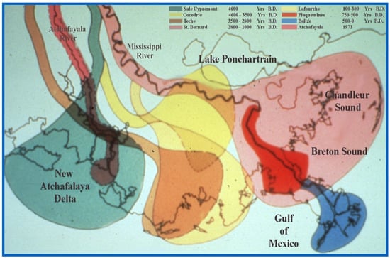
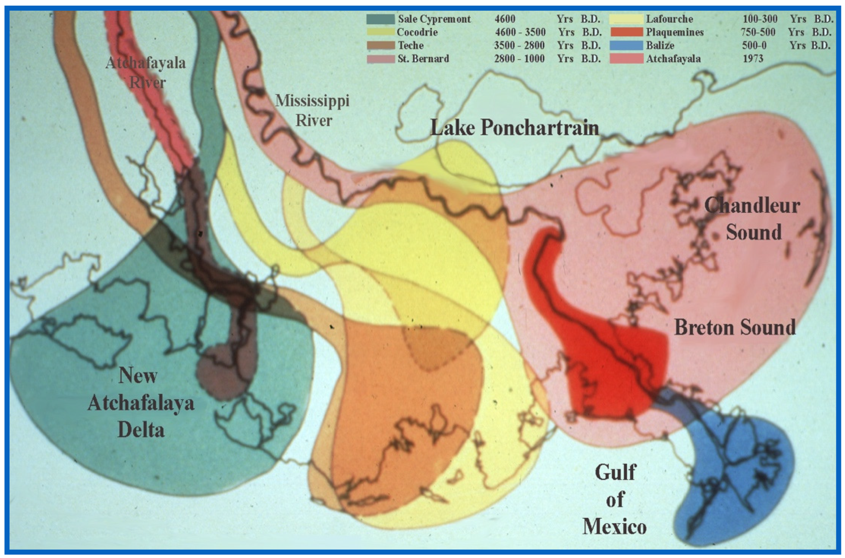
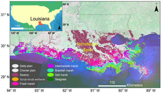
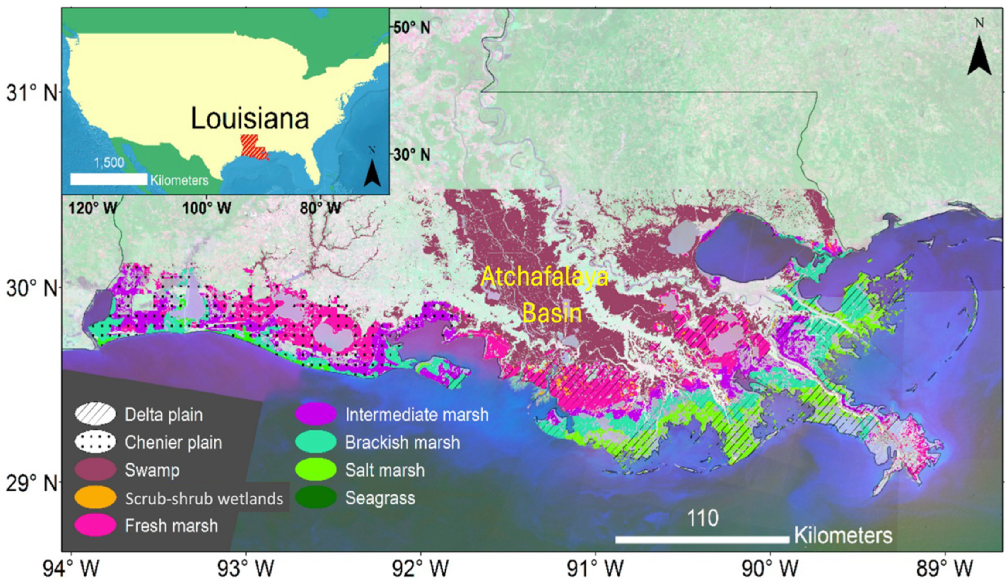
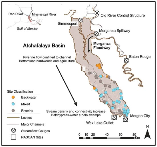
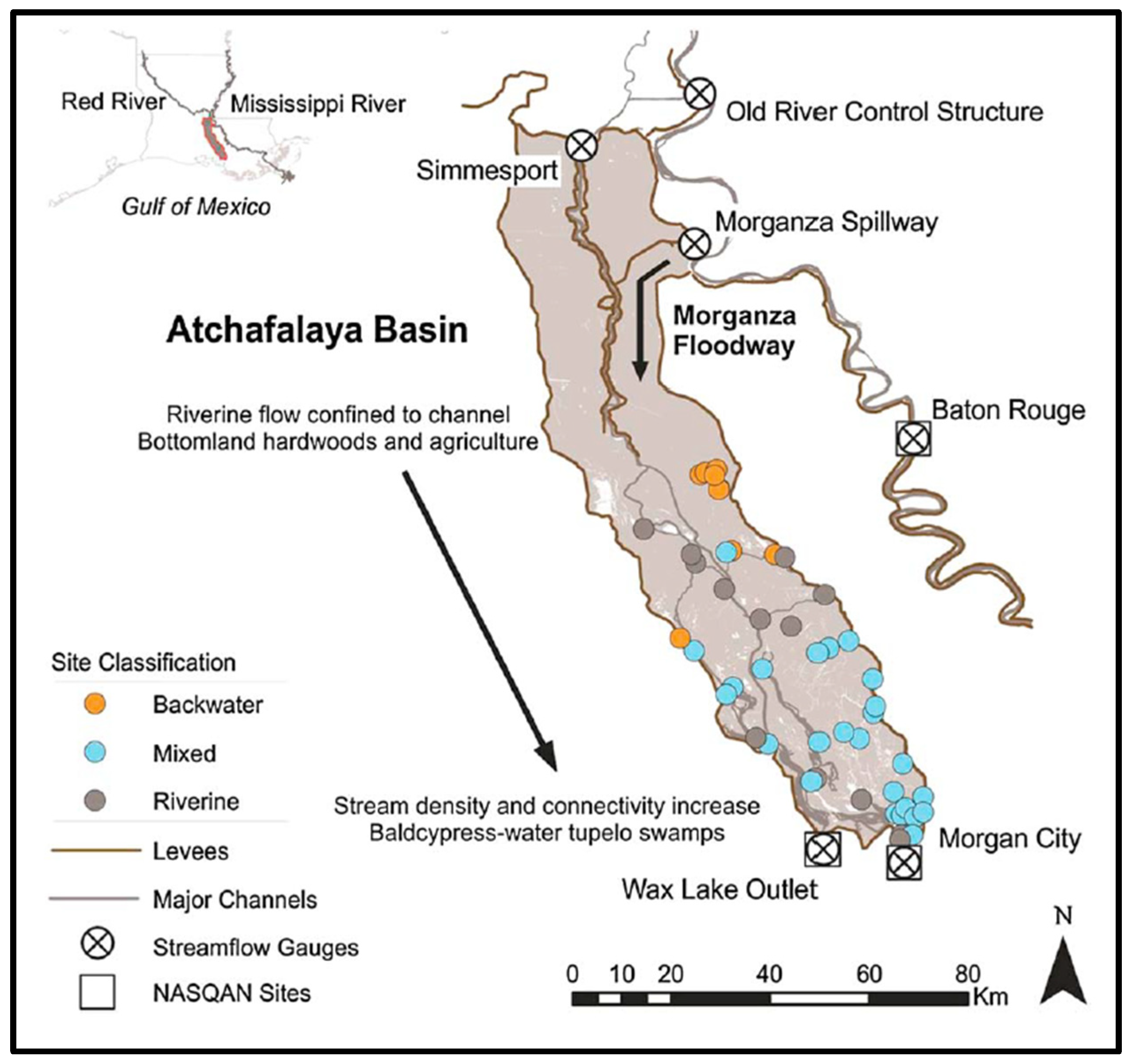
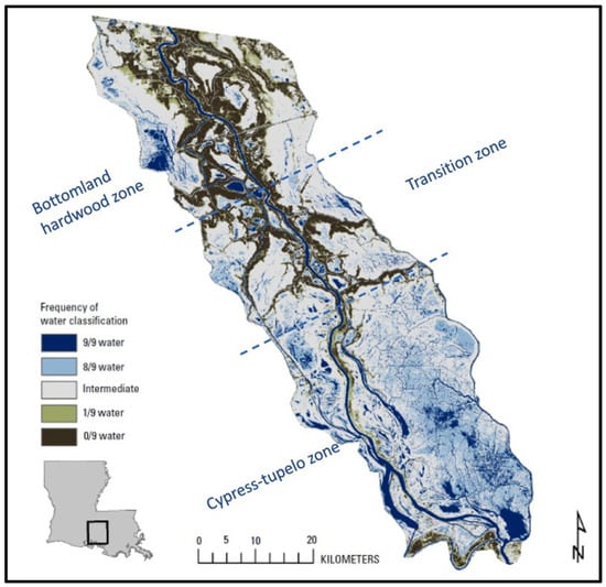
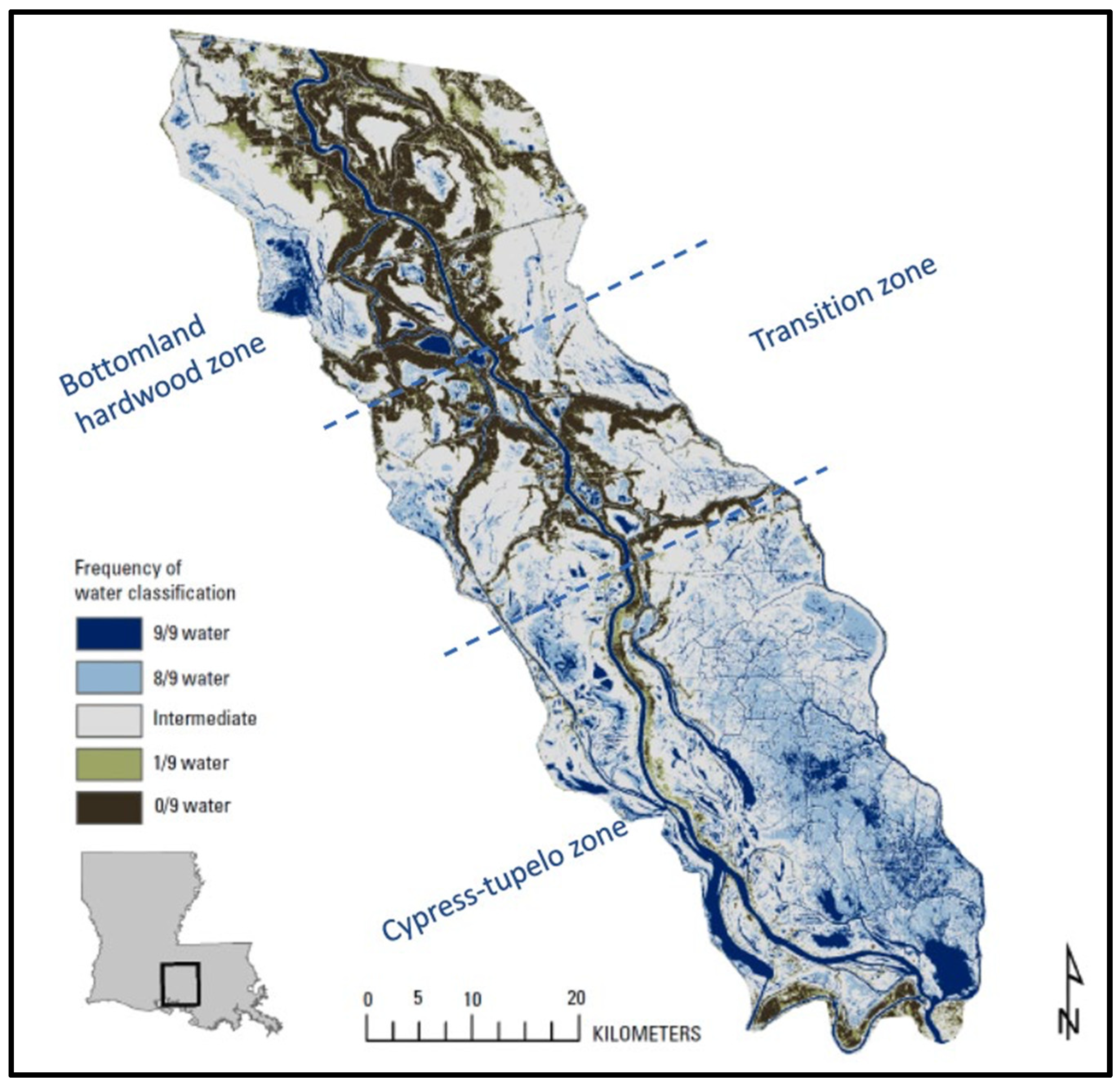
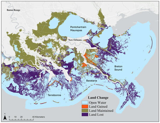
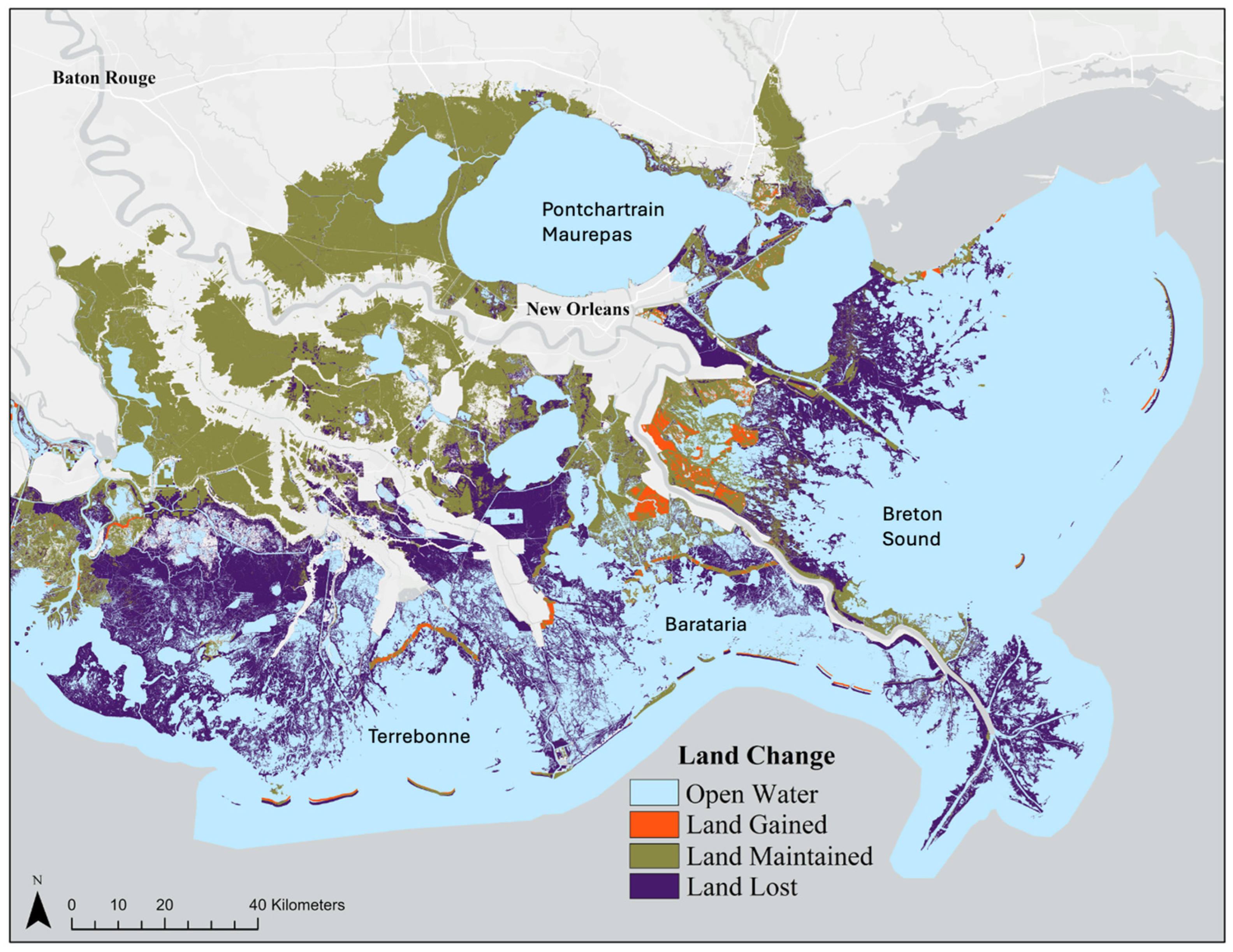
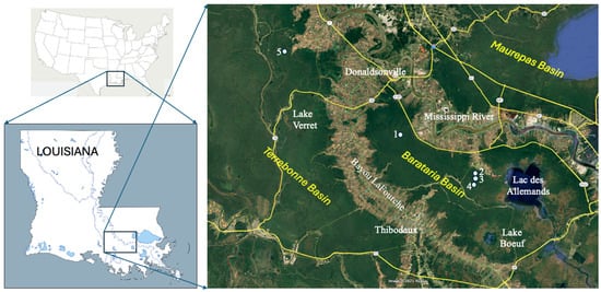
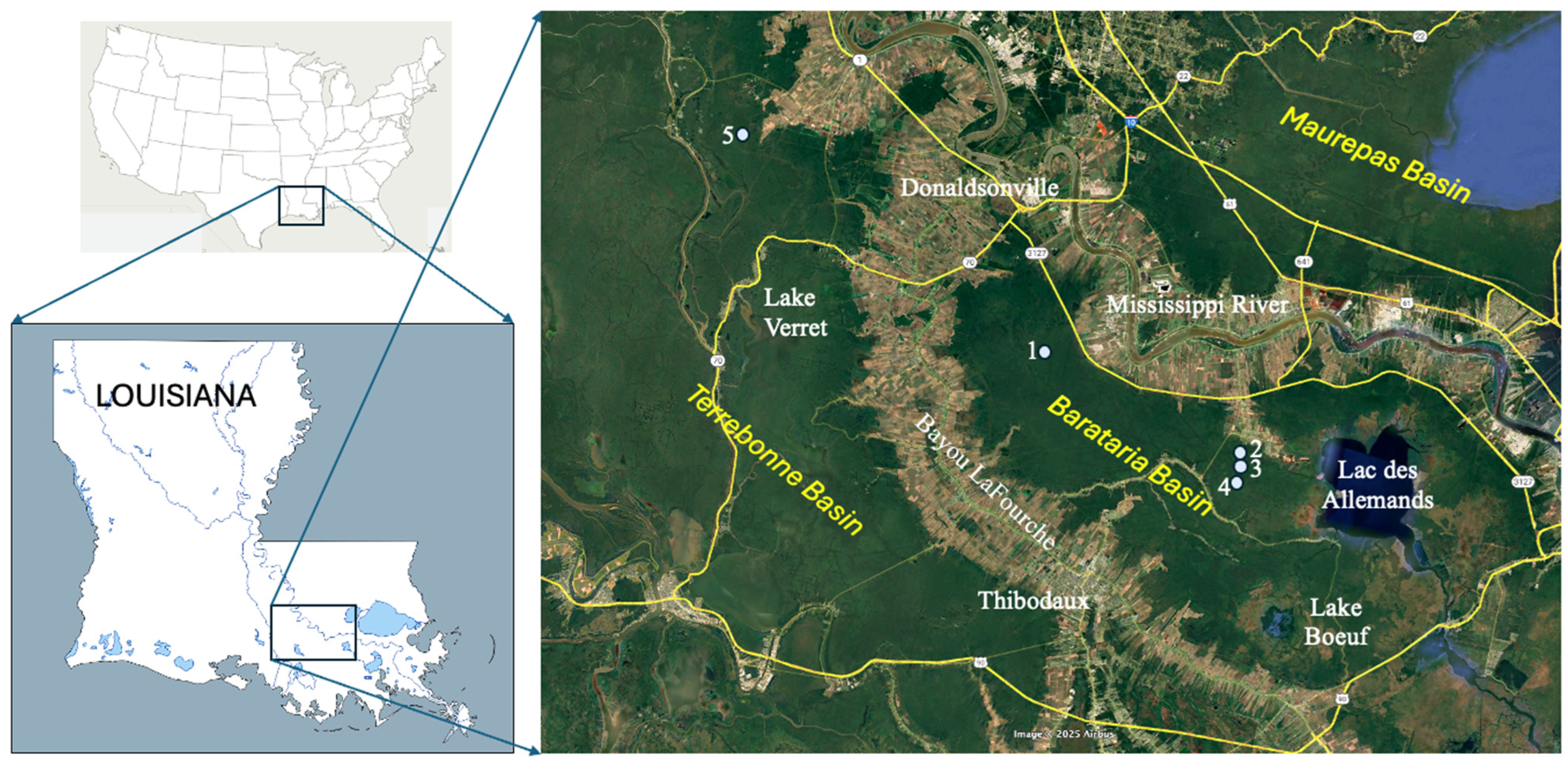
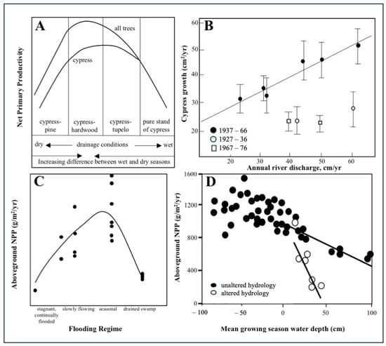
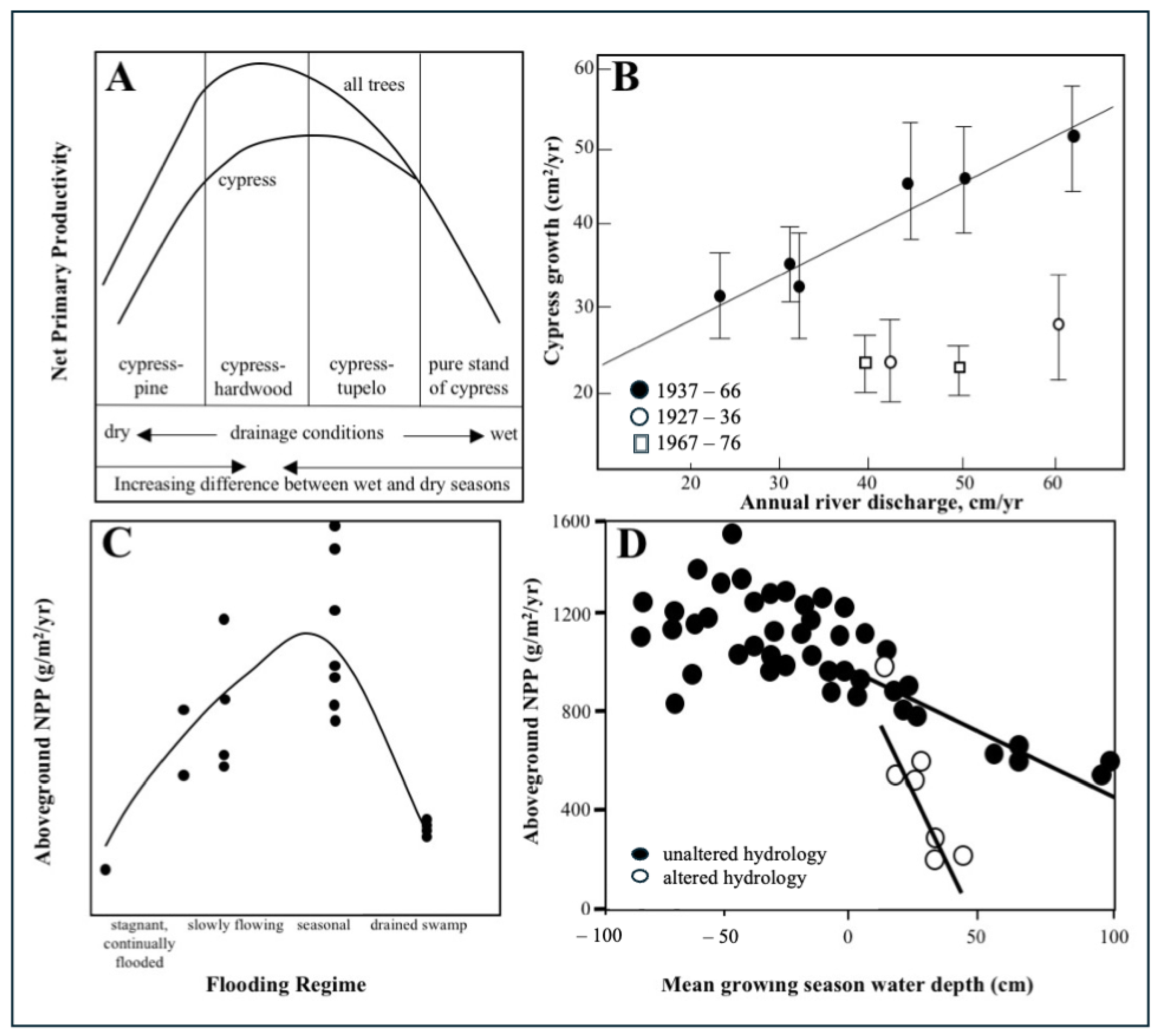
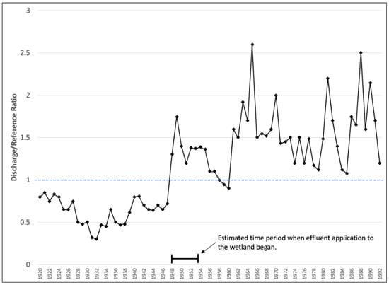
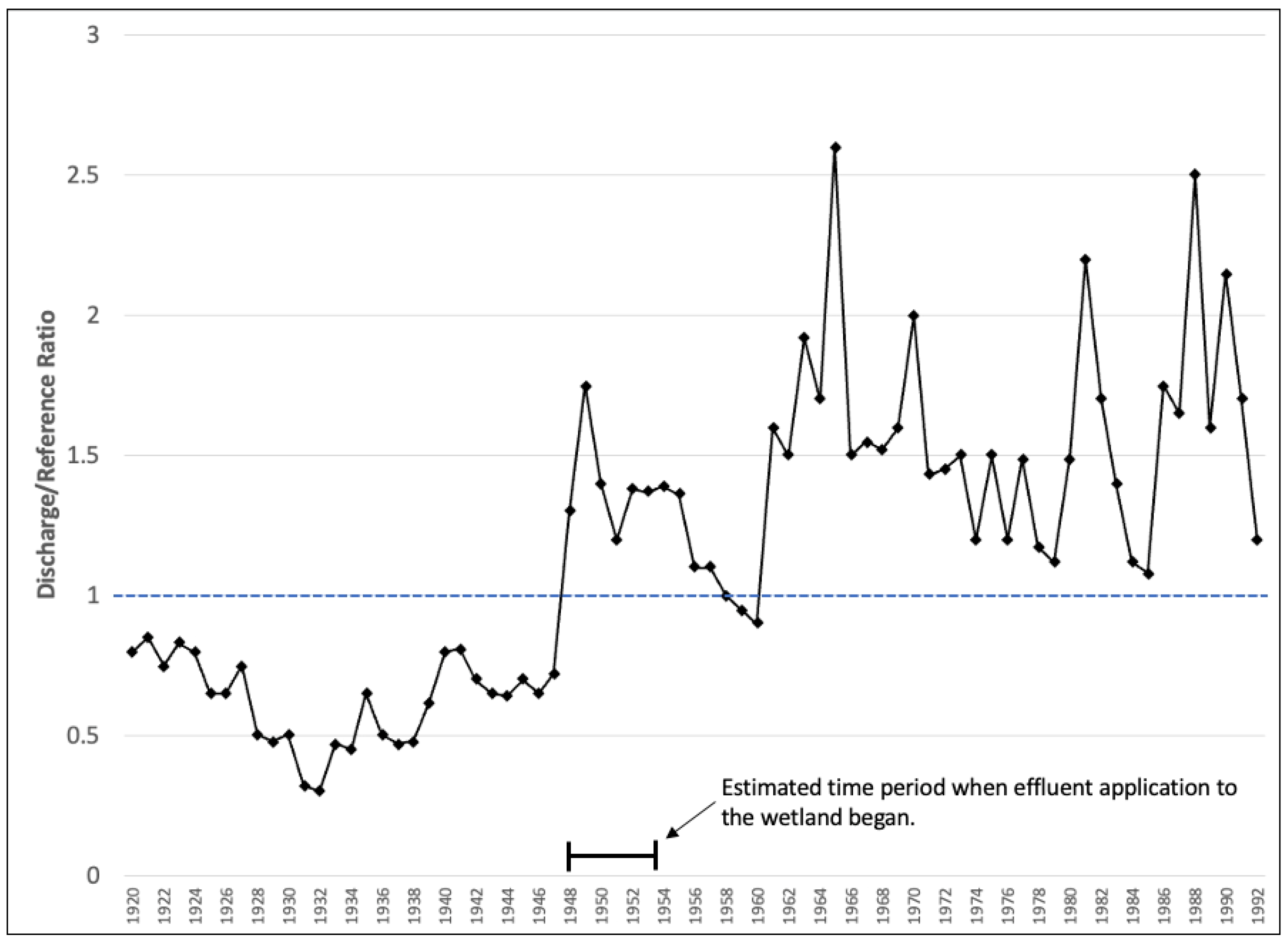
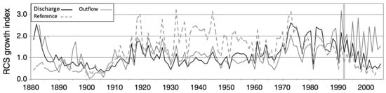
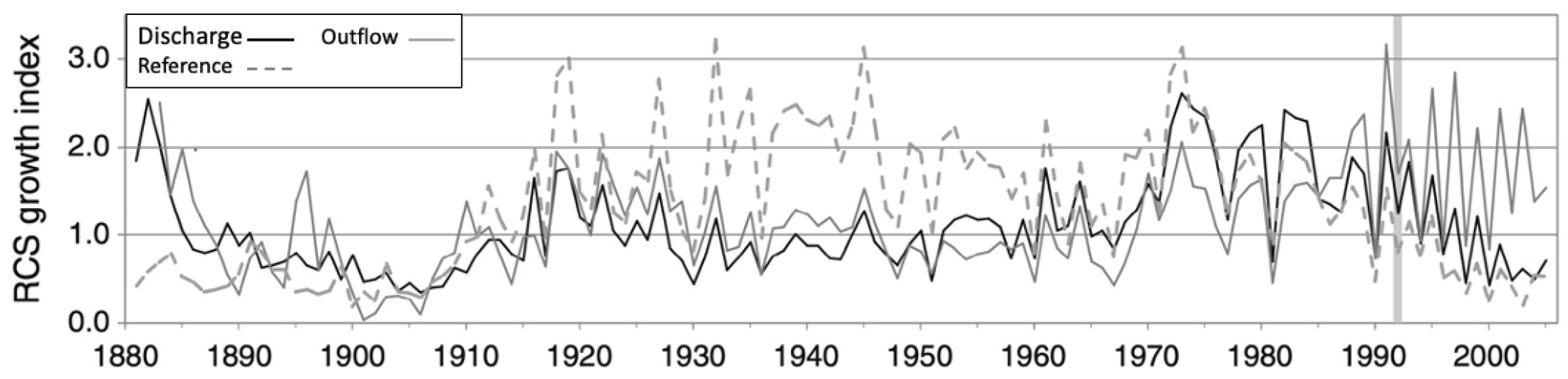
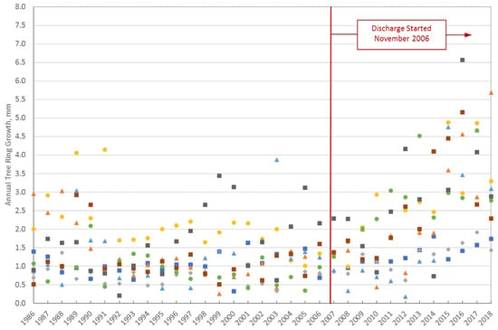
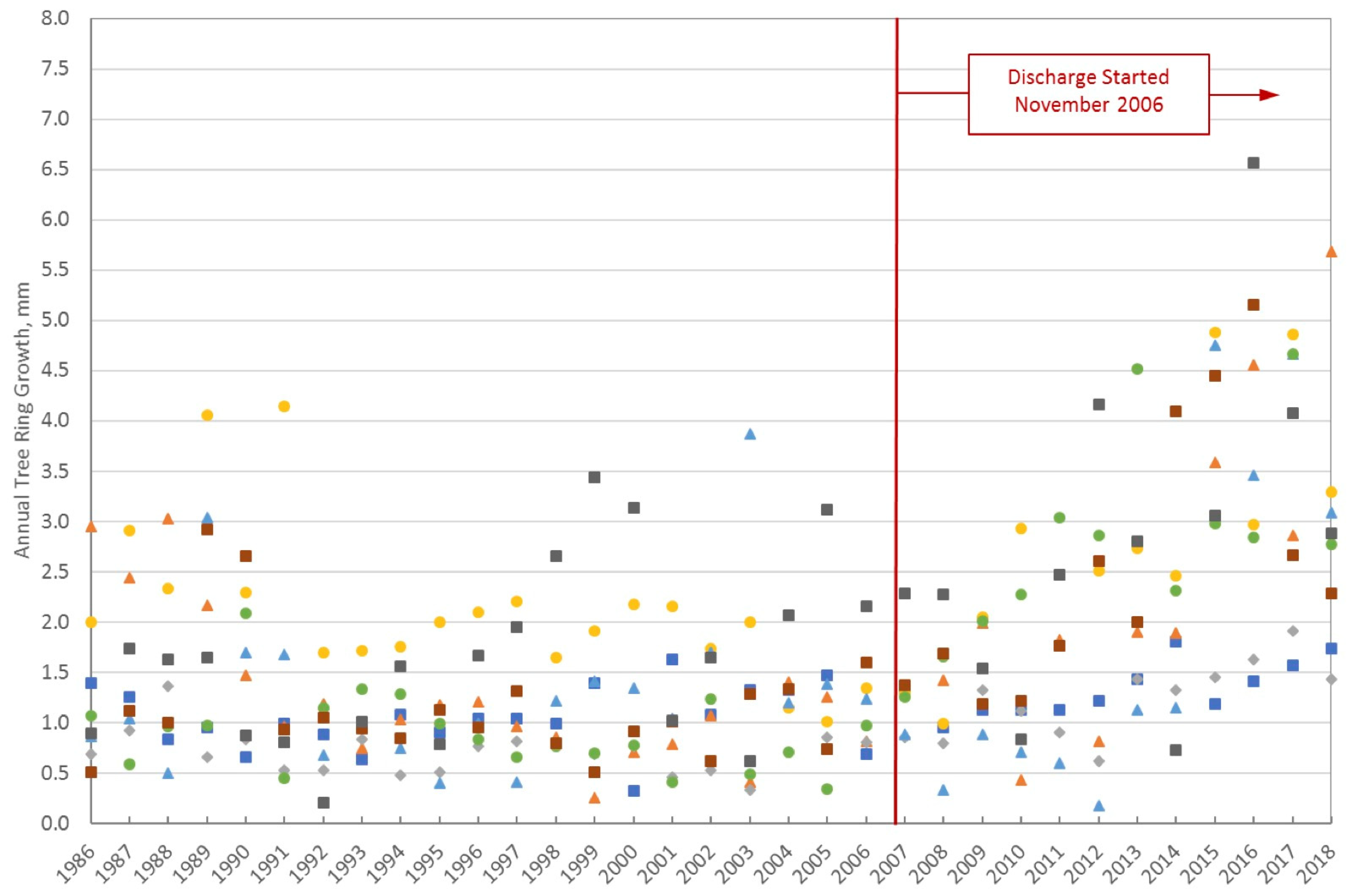
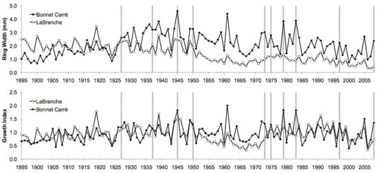
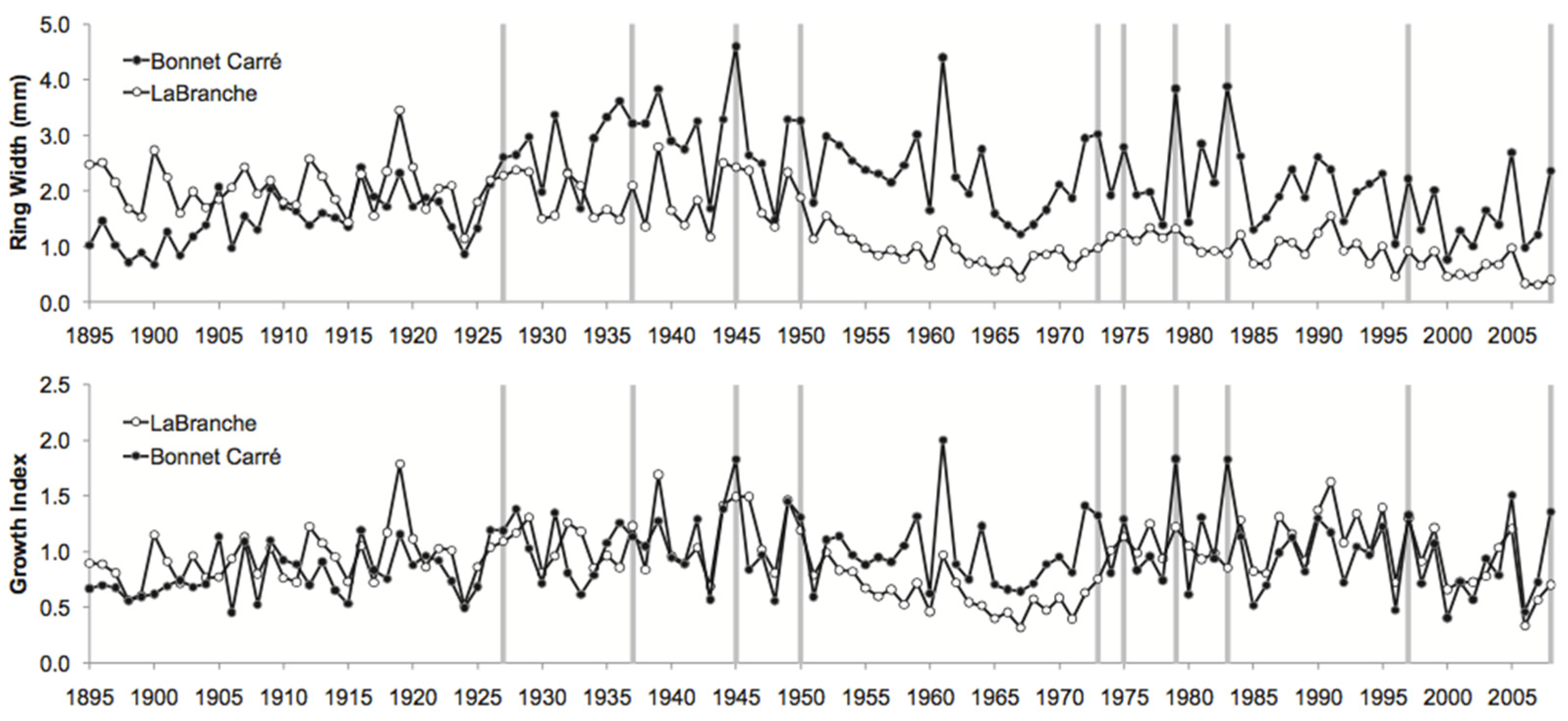
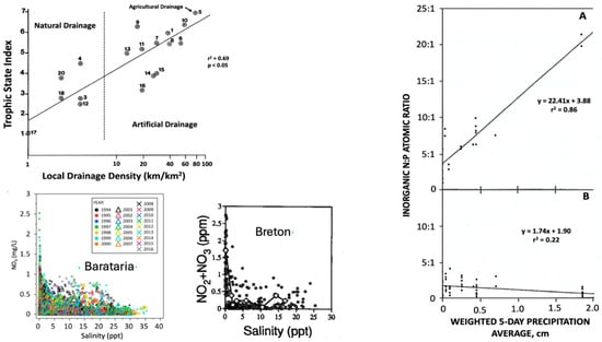
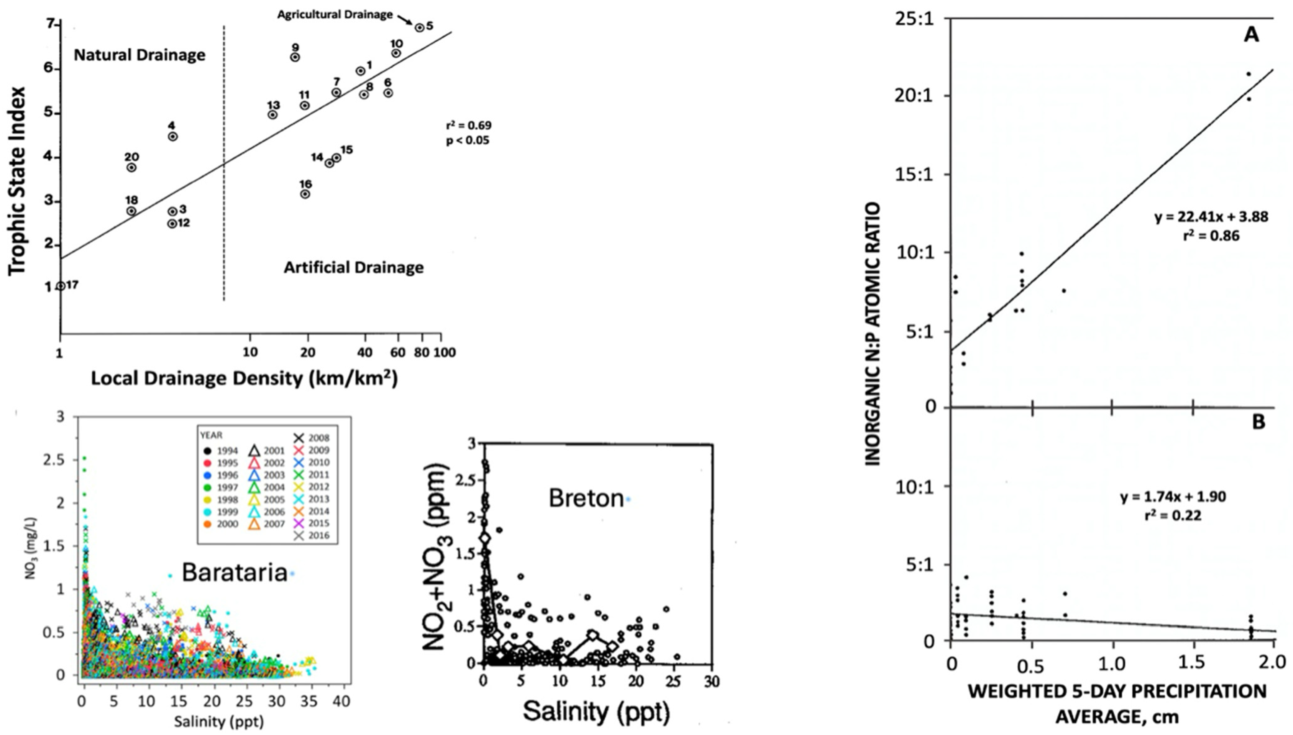
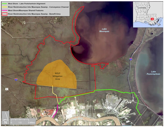
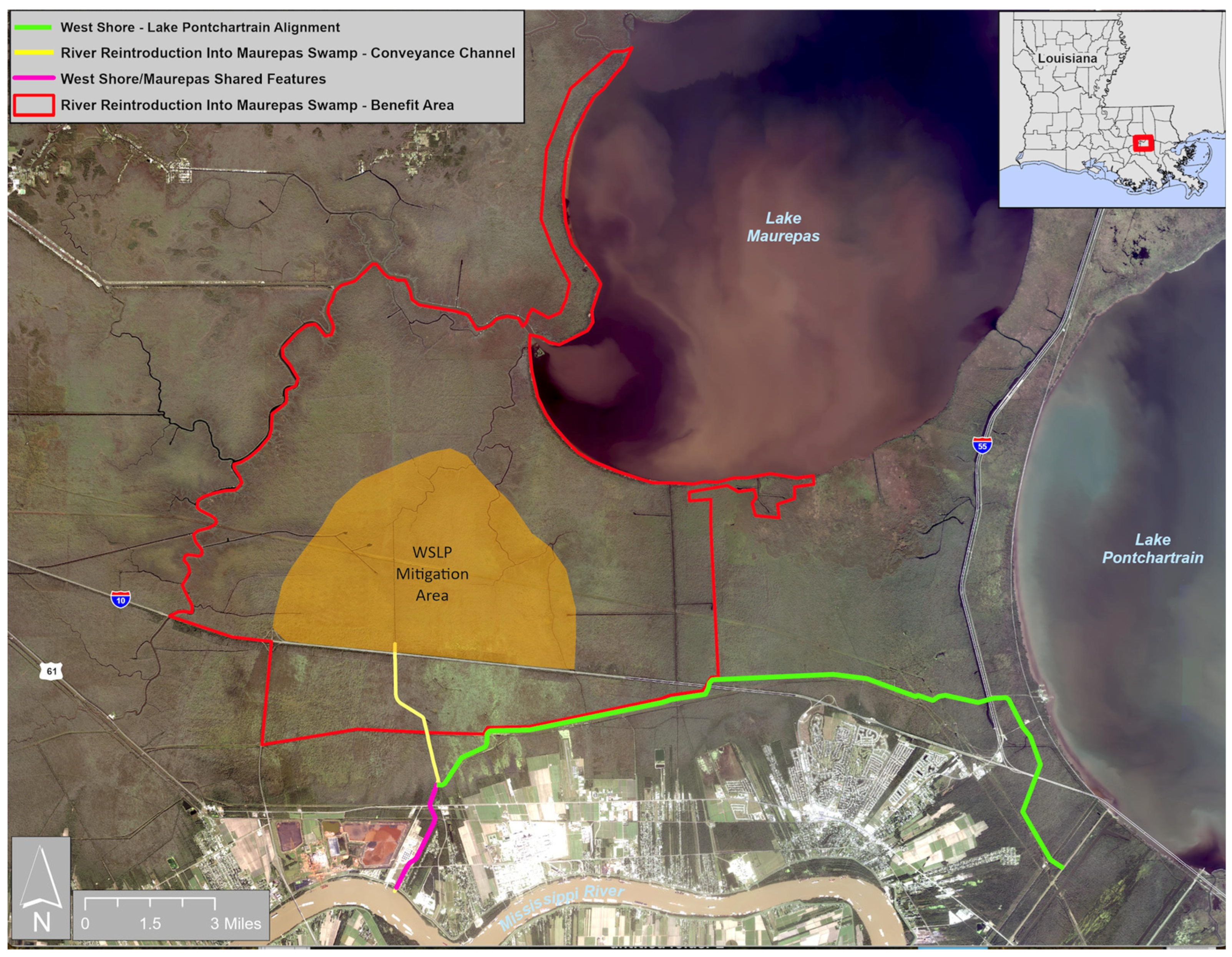

Disclaimer/Publisher’s Note: The statements, opinions and data contained in all publications are solely those of the individual author(s) and contributor(s) and not of MDPI and/or the editor(s). MDPI and/or the editor(s) disclaim responsibility for any injury to people or property resulting from any ideas, methods, instructions or products referred to in the content. |
© 2026 by the authors. Licensee MDPI, Basel, Switzerland. This article is an open access article distributed under the terms and conditions of the Creative Commons Attribution (CC BY) license.