


Abstract
Against the backdrop of climate change, forest fires increasingly undermine ecosystem stability and reshape species distributions in Heilongjiang Province. Therefore, quantifying the drivers of fire occurrence and conducting long-term fire risk forecasting holds critical value for regional ecological security. Centered on the forested regions of Heilongjiang Province, this study systematically assessed the relative contributions of multi-source factors—including topography, vegetation, and meteorological conditions—to fire occurrence and compared the predictive performance of three models: Deep Neural Network with Residual Connections (ResDNN), Artificial Neural Network (ANN), and Support Vector Machine (SVM). Modeling results based on historical fire records indicated that the ResDNN model achieved the highest accuracy (85.6%). Owing to its robust nonlinear mapping capability, it performed better in capturing complex feature interactions than ANN and SVM. These results demonstrate its strong applicability to forest fire prediction in Heilongjiang Province. Building on these findings, the study employed the best-performing ResDNN model in conjunction with CMIP6 multi-model climate projections to simulate and map the spatiotemporal probability of forest fire occurrence from 2030 to 2070. The results provide an intuitive representation of long-term fire-risk trajectories under future climate scenarios and offer scientific support for regional fire prevention, monitoring, early-warning systems, and forest management under climate change.
1. Introduction
Fire represents a fundamental Earth system process shaping most terrestrial ecosystems [1,2] and influencing global dynamics such as surface albedo and the carbon balance [3,4]. In recent decades, global warming has extended the average duration of the forest fire season by approximately 20% [5,6], accompanied by rising temperatures, more frequent droughts, and reduced air humidity [7]. The spatial footprint of fire impacts has expanded [8,9], while both the frequency and intensity of forest fires have escalated worldwide [10,11,12]. Forest fire occurrence is governed by numerous interacting factors—climate, topography, ignition sources, and fuel conditions—constituting a highly complex nonlinear process [13]. Consequently, non-parametric models offer greater suitability for fire prediction and variable interpretation than parametric approaches. Earlier forest fire prediction studies primarily relied on regression analysis and machine learning. For example, Peng et al. applied logistic regression to evaluate forest fire danger levels in Sichuan Province and identified monthly mean temperature as the dominant driver of forest fire occurrence [14]. Zhang et al. used Landsat-8 active fire data from 2014–2021 to develop an optimal-parameter logistic regression (OPLR) model for fire-risk zoning in Sichuan [15]. Brillinger et al. integrated historical fire records with elevation data to construct a Poisson-regression-based probability model supporting county-level fire resource allocation in California [16]. Jafari Goldarag et al. assessed forest fire risk in India using logistic regression and artificial neural networks (ANNs), demonstrating the superior predictive accuracy of the neural network model [17]. Guo et al. adopted logistic regression and random forest models to predict fire occurrence in northern China [18,19]. In recent years, machine learning has been increasingly applied to extract complex feature interactions in fire-related data, including neural networks, support vector machines (SVMs), random forests, kernel-based logistic classifiers, and neuro-fuzzy models [14,20,21,22,23,24]. These models have consistently shown more reliable predictive performance than traditional statistical algorithms [25,26]. Yang et al. proposed a forest fire prediction method using remote sensing data and machine learning techniques in Indonesia, demonstrating excellent performance in predicting fires in tropical peatlands [27]. The ECMWF research team developed a tool called “Probability of Fire” (PoF), which employs machine learning to predict global fire occurrences with high resolution and up to a ten-day lead time, showing remarkable accuracy and computational efficiency [28,29]. Cortez et al. utilized features such as temperature, relative humidity, wind speed, and rainfall to predict forest fires in northeastern Portugal using an SVM model [30]. The ANN, consisting of interconnected neurons with adjustable weights, is a widely used machine learning method. Unlike traditional multiple linear regression or parametric regression models, ANN offers strong self-learning and adaptive capabilities, making it highly effective in forest fire prediction. Sakr et al. used an ANN model to predict forest fire occurrences in developing countries, based on two meteorological factors [31].
With the advancement of deep learning technologies, these methods have shown greater efficiency in automatically extracting features from large datasets. Deep learning, due to its superior classification, recognition, and regression capabilities, outperforms traditional methods in processing large-scale data. As a result, more researchers and industry professionals are exploring deep learning applications in forest fire prediction [32]. Prapas et al. introduced a model combining Convolutional Neural Networks and Long Short-Term Memory networks (ConvLSTM) to generate high-resolution daily fire risk maps using multi-source data, such as meteorological, topographic, and human activity data, surpassing traditional random forest models [33]. Pang et al. [34] developed the Fire-Image-DenseNet (FIDN), a deep learning model that predicts forest fire burned areas using remote sensing data. This model integrates the spatial characteristics of environmental and meteorological drivers and was trained and tested on data from over 300 forest fire in the western United States between 2012 and 2019, accurately predicting the final burned area based on initial fire data and related geographic and meteorological factors. Zheng et al. [35,36] proposed an improved Dynamic Convolutional Neural Network (DCNN) model, “DCN_Fire”, to identify and classify forest fire risks under natural light conditions. This model combines transfer learning and Principal Component Analysis (PCA), enhancing image feature extraction and classification accuracy, making it suitable for forest fire early warning systems. In recent years, the advancement of computing power has led to the widespread adoption of Deep Neural Networks (DNNs), which have gradually replaced shallow models as the preferred tool for addressing complex non-linear problems. DNNs construct high-dimensional mapping relationships between input factors and fire risk probability by stacking multiple hidden layers. Satir et al. utilized an ANN model to integrate topographic and meteorological factors, successfully constructing a non-linear fire risk mapping relationship and significantly enhancing the precision of regional fire risk prediction [37]. Ku and Liu developed a DNN-based model to predict fire occurrence likelihood, which effectively identifies potential fire-prone areas by learning from historical fire data and related environmental factors, thereby improving prediction accuracy and timeliness [38,39].
However, despite the significant advantages of DNNs in feature representation, challenges remain in the deep design of their network architecture. Existing studies have shown that when the number of network layers becomes too deep, traditional DNNs are prone to “Vanishing Gradient” and “Degradation” phenomena, causing the model’s training error to increase instead of decrease as the depth increases [40,41]. To address this, this study incorporates Residual Connections to overcome the training bottleneck in deep networks. Research by He et al. [41] demonstrated that the residual structure, through Identity Mapping, enables direct gradient flow across layers during backpropagation. This approach not only mitigates the vanishing gradient issue but also significantly enhances convergence speed and feature extraction accuracy, ensuring the model’s depth and facilitating the precise capture of fire risk characteristics in the Heilongjiang forest area.
Based on the aforementioned background and research objectives, the main research contents of this work are as follows:
Construction of three forest fire prediction models—DNN with Residual Connections (ResDNN), ANN, and SVM—followed by a systematic comparative analysis to identify the optimal prediction model for the forest areas of Heilongjiang Province.
Analysis of the feature importance of environmental variables, such as topography, vegetation, and meteorology, quantifying the contribution of each driving factor to forest fire occurrence and identifying key factors influencing regional fire risk.
Mapping the spatial distribution of forest fire risk from 2030 to 2070 to reveal the spatiotemporal evolution of fire risk in Heilongjiang Province under future climate change scenarios.
2. Materials and Methods
2.1. Study Area Overview
Heilongjiang Province, located in northeastern China between 121°11′–135°05′ E and 43°26′–53°33′ N, is a typical mid-to-high latitude region. The province features a complex and diverse topography, with higher elevations in the northwest, north, and southeast, and lower regions in the northeast and southwest. Major mountain ranges include the Greater Khingan Mountains, Lesser Khingan Mountains, and Wanda Mountains, creating a varied forest landscape. Climatically, Heilongjiang lies in the cold temperate and temperate continental monsoon zones and is characterized by distinct seasons, including long, cold, and dry winters as well as windy and relatively dry springs and autumns. These conditions are conducive to the development of meteorological conditions associated with high fire risk. As a key state-owned forest area in China, Heilongjiang is rich in forest resources, with a forest coverage rate of approximately 47.3%. The primary vegetation types include cold temperate coniferous forests and temperate mixed coniferous and broad-leaved forests, with dominant species such as larch, Korean pine, and white birch. The forest floor has a high and continuously distributed fuel load, making it a critical area for forest fire prevention and control in China.
2.2. Response Variable
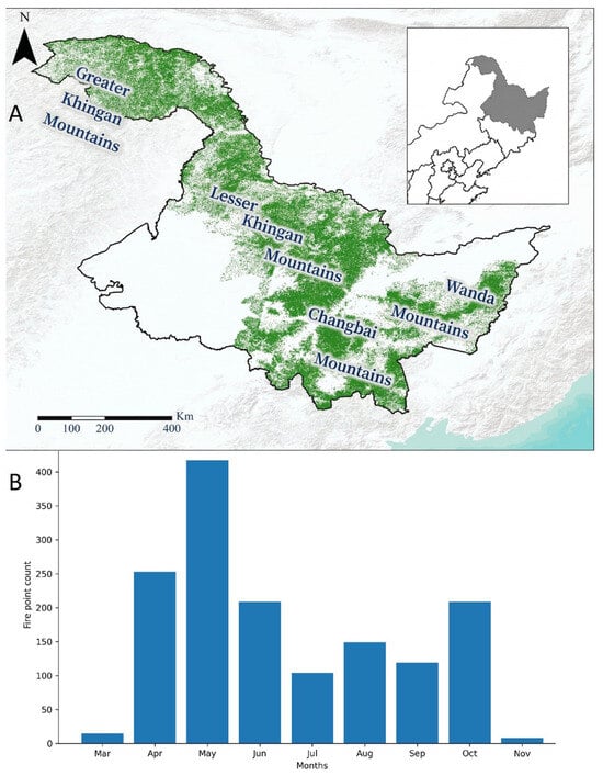
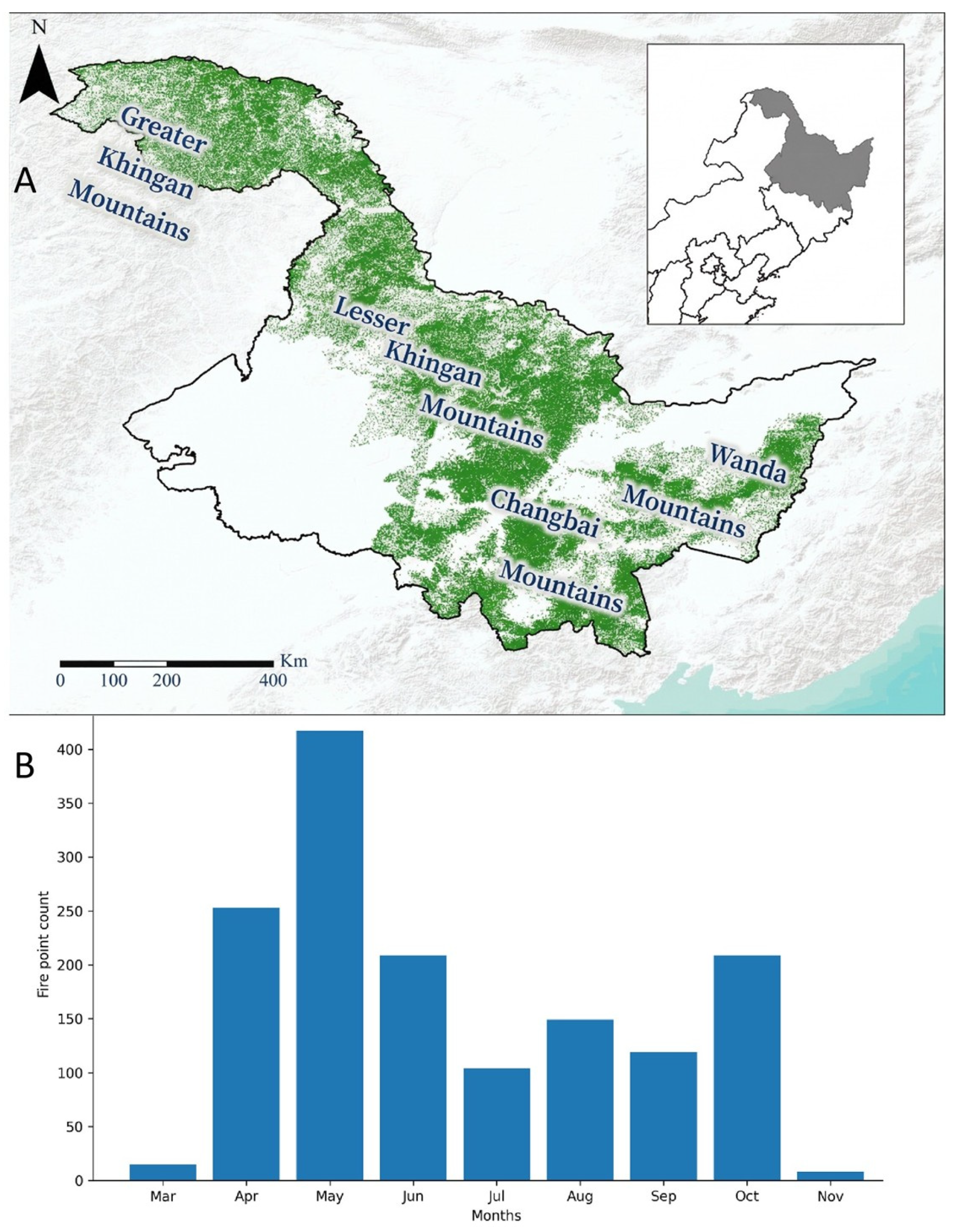
This study employed a 1 km × 1 km spatial resolution raster unit as the basic analysis scale, defining forest fire occurrence probability as a binary response variable (fire pixels are assigned a value of 1, and non-fire pixels are assigned a value of 0). Fire sample construction was based on the MODIS (MOD14A1) thermal anomaly product during the fire prevention period (March to November) from 2011 to 2020. It is important to note that the temporal distribution of these extracted fire pixels is inherently non-uniform across the months and years, reflecting the strong climate-driven nature of regional forest fires. Statistically, as illustrated in Figure 1, the fire samples exhibit a distinct seasonal bimodal pattern. They are primarily concentrated during the spring fire season and the autumn fire season, driven by dry and windy conditions. Conversely, fire occurrences drop to near zero in the winter months due to extensive snow cover. We deliberately preserved this natural temporal clustering in our dataset to ensure the deep learning model accurately learns the true seasonal variations and climate-driven fluctuations. To minimize false alarms and environmental noise interference in satellite remote sensing data, a high-quality data screening and cleaning process with multi-dimensional spatiotemporal consistency constraints was applied. Specifically, only pixels with a confidence level greater than 85% and labeled as “vegetation fire” were retained. Additionally, high-resolution land use and forest cover data were used for spatial masking to eliminate non-forest fire signals, such as farmland straw burning and industrial heat sources. Furthermore, ground fire monitoring records provided by the forestry department of Heilongjiang Province during the same period, which include precise geographic coordinates, fire causes, and burnt areas, were incorporated as ground truth references. These were used for spatial consistency verification and error correction of the remote sensing inversion results. Through this process, a high-confidence, spatially accurate spatiotemporal distribution database of forest fires in Heilongjiang Province was established, providing a reliable data foundation for subsequent model training, risk assessment, and the development of prevention and control strategies.
Figure 1.
Geographic location of the study area in Heilongjiang Province and the temporal distribution of forest fires. (A) The geographic map shows the boundary and major mountain ranges of the study area in Heilongjiang Province, China. (B) The histogram shows the monthly count of forest fire incidents in the study area from 2011 to 2020.
2.3. Selection of Explanatory Variables
Screening appropriate predictors is a critical step in forest fire modeling. Global forest fire activity is governed by four hierarchical processes: vegetation type, human disturbance, fire weather, and topography. These processes function as interconnected “switches”, collaboratively regulating the regional fire disturbance mechanism [42]. In this study, 13 variables encompassing climate, vegetation, topography, and human factors were selected, forming a comprehensive system of potential environmental driving factors for forest fires (Table 1).
Table 1.
Summary of environmental variables used in forest fire prediction.
Meteorological factors are fundamental drivers in the occurrence and spread of forest fires, directly influencing fire ignition thresholds and behavior by regulating the moisture content of surface combustibles and environmental thermal conditions. Studies in the Heilongjiang forest area have shown that dynamic changes in the meteorological environment provide the physical basis for regional fire-risk fluctuations, highlighting the importance of constructing a multi-dimensional meteorological feature system to capture the spatiotemporal patterns of fire occurrence [43]. Accordingly, key meteorological indicators influencing the drying process of combustibles were selected, and the data were obtained from the China Meteorological Data Service Center (CMData). Meteorological observations were processed and spatialized in ArcMap to generate monthly raster layers, and the corresponding values were extracted according to the spatial locations of the fire samples. To ensure consistency with the other explanatory variables, all meteorological data were standardized to a common spatial resolution of 1 km before model input. Given that this study focused on regional fire-occurrence risk rather than the short-term weather conditions of individual fire events, and that fire occurrence at the regional scale shows distinct monthly variation and can be related to monthly mean fire-weather conditions [44], while forest fire occurrence probability can also be predicted using monthly climate variables [45], monthly climatic variables were adopted to characterize the broader climatic conditions associated with fire occurrence. Monthly maximum temperature (Tmax), monthly minimum temperature (Tmin), and monthly average temperature (Tave) were chosen to represent the environmental heat supply status. Temperature increases not only accelerate the evapotranspiration of surface moisture but also lower the thermal energy threshold required for combustibles to reach ignition [46]. Additionally, monthly precipitation (PPT) and relative humidity (RH) were incorporated as moisture supply indicators, both of which hinder the ignition of combustibles and the spread of fires by raising atmospheric and soil moisture levels. To quantify the cumulative drying effect of climate on vegetation and combustibles, this study introduced the Climate Moisture Deficit (CMD), a comprehensive bio-climatic indicator. CMD represents the cumulative difference between potential evapotranspiration and precipitation, effectively reflecting the physiological moisture stress of vegetation and the deep drying process of surface dead combustibles. In the context of frequent seasonal droughts in Heilongjiang Province, CMD can mechanistically characterize fire risk under extreme dry conditions, addressing the limitations of individual precipitation or temperature variables in describing long-term water balance [47].
Topography, as the static framework of the regional environment, significantly influences local microclimate and vegetation distribution by reshaping the redistribution of water and heat resources [48]. This study utilized a Digital Elevation Model (DEM) with a spatial resolution of 30 m (data sourced from Geospatial Data Cloud, http://www.gscloud.cn) to extract three key topographic variables—Elevation, Slope, and Aspect—under the ArcGIS 10.8 platform (Esri, Redlands, CA, USA). These variables were then resampled to a 1 km grid using the Kriging interpolation method to align with the model’s input requirements. After resampling, the topographic variables were spatially matched with the other explanatory variables, and their values were extracted to the fire and non-fire sample points for model construction. Elevation is directly related to the vertical thermal gradient of the atmosphere (lapse rate), which determines the timing of snowmelt and vegetation phenology across different elevation zones, thereby influencing the start and end of the fire prevention period. Slope, a critical parameter in fire behavior dynamics, plays a key role in fire spread. Steep terrain accelerates the upward spread of fire by enhancing thermal convection efficiency (the “chimney effect”) and reduces the retention time of precipitation on the surface, exacerbating the drying of soil and litter [49]. Aspect governs the surface solar radiation budget, with sunny slopes (e.g., south-facing slopes) receiving higher solar radiation flux than shady slopes (e.g., north-facing slopes). This results in combustibles on sunny slopes maintaining lower moisture content for extended periods, making them more prone to ignition and contributing to higher fire intensity [50].
Human disturbance, as a significant non-natural driver of forest fire distribution, directly influences the initial spatial positioning of fire sources [51]. Due to the challenges in directly tracking human activity, this study developed a proxy variable system based on the “accessibility-risk” coupling mechanism. The study focused on Euclidean distances from the grid center to residential areas (resa_dist), railways (lrrl_dist), and roads (lrdl_dist) to quantify the exposure probability to anthropogenic fire sources. Data on roads and residential areas were sourced from the 1:250,000 National Fundamental Geographic Database.
The infrastructure network not only serves as the primary conduit for human access to forest areas but also acts as a hotspot for high-frequency accidental fire sources, such as agricultural burning in border zones, discarded cigarette butts, and train braking sparks. The spatial proximity effect significantly weakens the natural environmental constraints on fire occurrence, causing fire risk probability to increase exponentially in areas near transportation corridors and residential areas, thereby exhibiting notable edge effects [52].
Forest vegetation, as both the material basis and energy carrier for fire occurrence, plays a pivotal role in determining the load distribution and combustion heat value of combustibles through its community structure and physical properties [53]. The combustible distribution map provided by the Institute of Botany, Chinese Academy of Sciences, was used to extract combustible information for this study. Different stand types exhibit distinct flammability characteristics: cold temperate coniferous forests (e.g., larch) are typically rich in resin and oil, with slowly decomposing litter that dries quickly, leading to high ignition sensitivity; in contrast, broad-leaved forests have denser canopies and a relatively moist environment, providing greater fire resistance. These biophysical differences, determined by vegetation attributes, are key internal factors influencing fire risk variations under similar meteorological conditions [54].
The Permutation Feature Importance (PFI) method was employed in this study. This method, based on prediction error sensitivity analysis, was implemented using the scikit-learn library in the Python 3.9 (Python Software Foundation, Wilmington, DE, USA) environment. By keeping other variables constant, the target feature in the test set was randomly permuted to disrupt its original relationship with the dependent variable, and the decay in model prediction accuracy (Accuracy) was observed. To mitigate random perturbation bias, the permutation test was repeated 10 times for each feature, and the statistical mean of the accuracy decrease was used as the core metric to assess the relative importance of each factor, ultimately identifying the key environmental variables driving fire risk patterns in the Heilongjiang forest area. To complement the global ranking provided by PFI, SHAP (Shapley Additive Explanations) was further introduced for model interpretation. SHAP was used to reveal how different feature values contributed to the model output across samples, thereby providing additional insight into the heterogeneity and complexity of feature effects.
2.4. Model Construction and Accuracy Evaluation
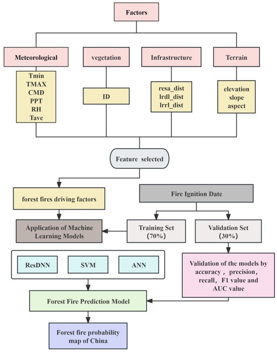
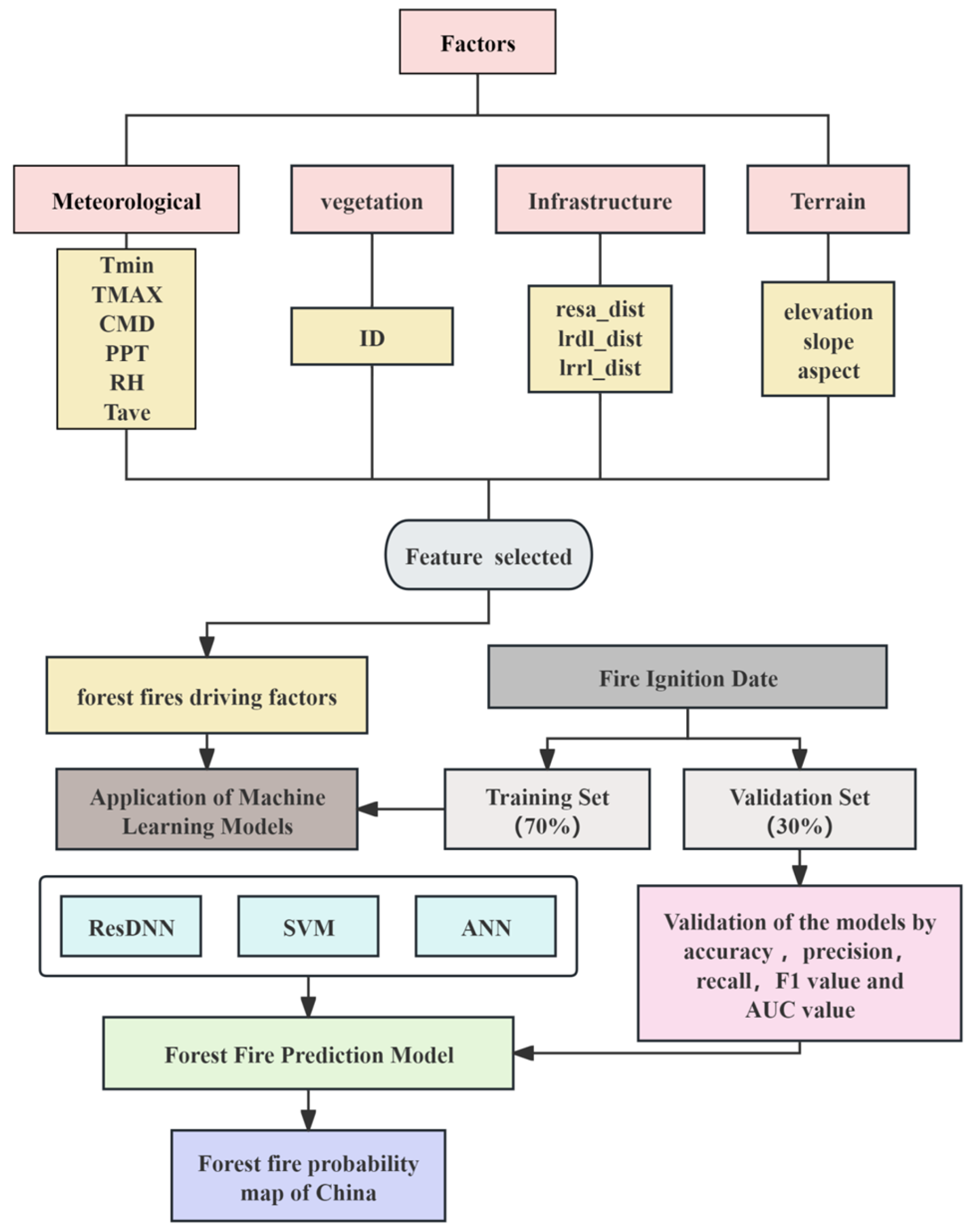
To mitigate training bias resulting from data class imbalance, this study constructed a balanced dataset with a 1:1 ratio of positive and negative samples. Non-fire points were generated using ArcGIS software, strictly excluding non-forest areas such as water bodies and impervious surfaces. A 10 km buffer zone around actual fire points was used as an exclusion zone to avoid generating non-fire samples too close to observed fire locations, as this could weaken sample independence and introduce spatial autocorrelation; this treatment is also consistent with previous studies [55,56]. Multi-source features, including meteorological, topographic, human, and combustible factors, were extracted based on sample coordinates using methods such as spatiotemporal matching, proximity analysis, and spatial overlay. The Z-score standardization method was applied to eliminate dimensional heterogeneity between variables. To assess feature factors and model performance, the dataset was randomly split, with 70% of the pre-processed sample data used for training and 30% for testing, facilitating the construction and evaluation of ResDNN, ANN, and SVM models. The overall technical approach and modeling framework are shown in Figure 2. Additionally, to support future scenario predictions, the Multi-Model Ensemble (MME) mean method was applied to integrate CMIP6 meteorological data, creating a high spatiotemporal resolution prediction database for the period 2030 to 2070 based on a 1 × 1 km grid for the entire region.
Figure 2.
Technical route map.
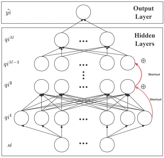
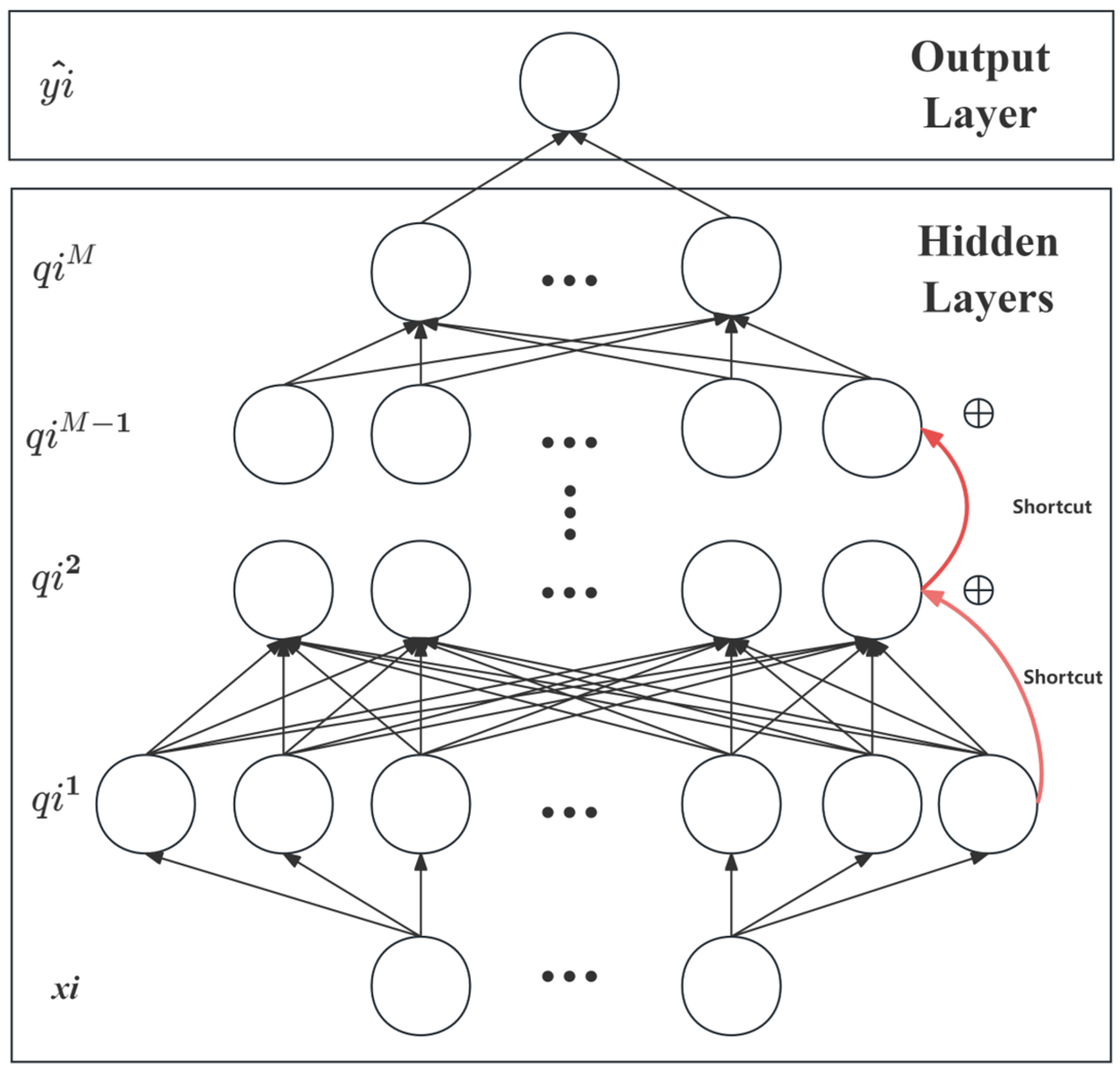
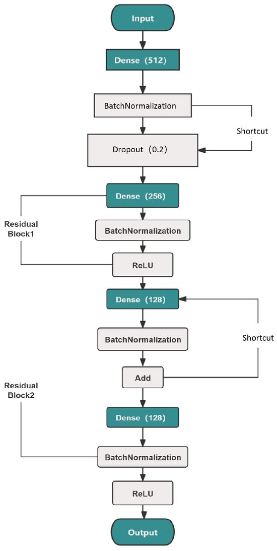
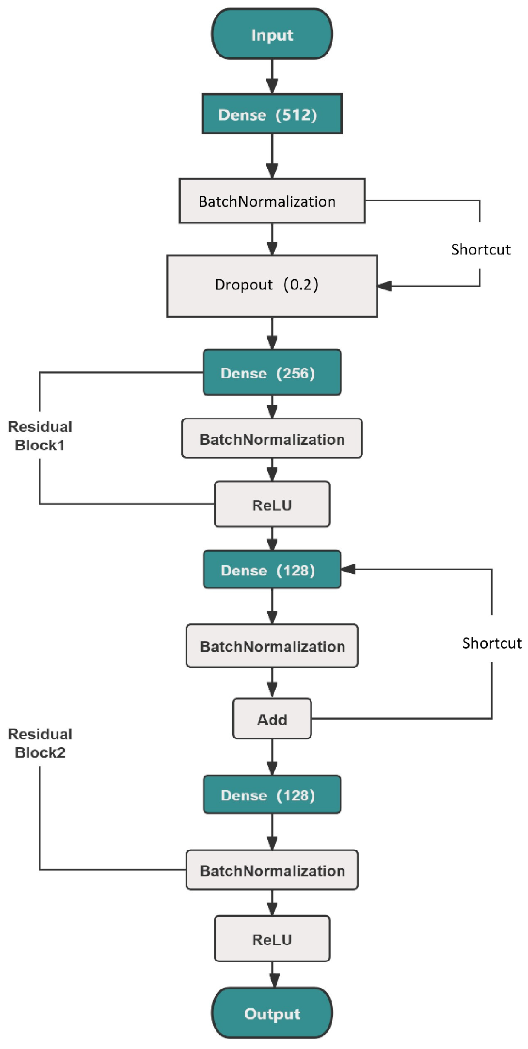
Regarding model selection, this study developed a DNN model based on the Residual Learning Framework (ResDNN) (Figure 3 and Figure 4) to precisely predict forest fire occurrence probabilities. The core architecture of the model includes an input layer, a high-dimensional feature mapping layer, cascaded Residual Blocks, and an output layer. To address the common vanishing gradient and degradation issues in deep network training, a “Shortcut Connections” mechanism was introduced. This Identity Mapping enables direct data flow across layers, facilitating the backpropagation of error gradients, thereby supporting the model in capturing high-order non-linear features between environmental factors while maintaining stability during training despite increased network depth [41]. In the specific data flow, standardized input data are first mapped to a high-dimensional feature space via a fully connected layer with 512 neurons, followed by two consecutive residual blocks (with 256 and 128 neurons, respectively). Each residual block transmits the signal through two paths: the main path undergoes non-linear transformation via a fully connected layer (Dense), a Batch Normalization (BN) layer, and a ReLU activation function, while the shortcut path transmits the signal directly. The two signals are then fused through an addition (Add) operation. To enhance model generalization and prevent overfitting, a Dropout layer (dropout rate set to 0.2) was embedded in each residual block to reduce feature dependencies by randomly deactivating neurons during training [57]. The key configuration parameters of the network, specifically the number of neurons in each hidden layer and the dropout rate, were optimized through a grid search strategy. This method systematically evaluates various parameter combinations to identify the optimal setup that maximizes model generalization and stability [58]. During the network training process, the Adam optimizer was employed with an initial learning rate of 0.0001, a batch size of 64, and a maximum of 100 epochs. To guarantee stable convergence and prevent overfitting, an Early Stopping mechanism (patience = 30) and a dynamic learning rate adjustment strategy were integrated. Finally, the fused deep features are passed to the output layer and compressed to the [0, 1] interval using the Sigmoid activation function to represent the predicted probability of forest fire occurrence.
Figure 3.
ResDNN architecture schematic.
Figure 4.
Detailed architecture of the ResDNN model for forest fire occurrence prediction, including fully connected layers, Batch Normalization, Dropout, ReLU activation, and two residual blocks with shortcut connections.
As a control group, an ANN model was constructed using the Keras framework within the Python environment. The model utilizes a standard Multi-Layer Perceptron architecture with two fully connected hidden layers, containing 64 and 32 neurons, respectively. Both hidden layers use the ReLU (Rectified Linear Unit) activation function, known for its high computational efficiency and ability to accelerate model convergence. The output layer employs a Sigmoid activation function, mapping the weighted sum of neurons to a probability range between 0 and 1. The model was compiled and trained using the Adam optimizer and the binary cross-entropy loss function. Additionally, an SVM model was developed using the scikit-learn library. Given the potential non-linear relationship between forest fire drivers and occurrence probability, the Radial Basis Function (RBF) kernel was selected to perform high-dimensional feature mapping. The penalty coefficient C was set to 1.0, and the kernel coefficient gamma was configured for automatic scaling (scale).
To ensure the fairness and comparability of the experiments, all models were developed under the same experimental setting using the same forest fire risk dataset from Heilongjiang Province and the same 13 driving factors as input variables. In addition, the same preprocessing procedure, fixed random seed (seed = 42), and data partitioning strategy were applied, with the dataset randomly divided into a training set and a test set at a ratio of 7:3. This controlled design minimized potential interference from data processing and partitioning differences, allowing model performance differences to be attributed primarily to the algorithmic architecture.
To evaluate the generalization performance of the models, a confusion matrix was used, with Accuracy, Precision, Recall, and F1-score as the primary metrics. Additionally, the Area Under the Curve (AUC) value was introduced to quantify the model’s overall discrimination efficiency, enabling a multi-dimensional quantitative analysis of forest fire prediction accuracy.
Measures the overall correctness of predictions. Ideally, a value near 1 indicates perfect classification of both fire and non-fire samples.
Reflects the reliability of predicted fire alarms. Ideally, a high value is required to minimize false positives (false alarms).
Also known as Sensitivity, it measures the ability to detect actual fire events. Ideally, this value should be maximized to avoid missed reports (false negatives).
The harmonic mean of Precision and Recall. Ideally, it provides a balanced assessment of model performance, especially for imbalanced fire datasets.
Calculated to construct the ROC curve. Ideally, the model should achieve a high TPR (sensitivity) while maintaining a low FPR (false alarm rate).
Quantifies the aggregate discriminative ability across thresholds. Ideally, an AUC close to 1 represents perfect separability between fire and non-fire classes.
3. Results
3.1. Feature Importance
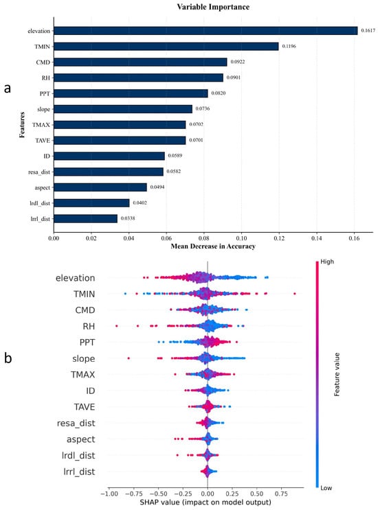
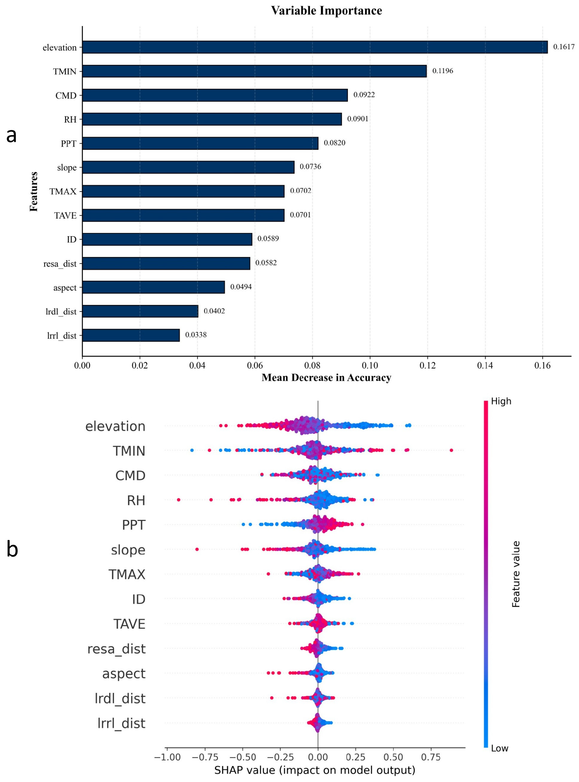
The PFI analysis results based on ResDNN are presented in Figure 5a. The contribution of various environmental driving factors to model prediction accuracy exhibits distinct step-like distribution characteristics. Elevation and Tmin showed the highest predictive efficacy, occupying a dominant position among all input features. Following these, CMD, RH, and PPT were also found to be significant contributors. Slope, Tmax, and Tave had a moderate impact. Additionally, while combustible type (ID) and distance to residential areas (resa_dist) had a smaller contribution compared to the aforementioned meteorological and topographic factors, they still influenced the model’s prediction performance. In contrast, the feature importance scores for Aspect, distance to roads (lrdl_dist), and distance to railways (lrrl_dist) were relatively low, indicating that their contribution to forest fire occurrence at the scale of this study is minimal. However, despite ranking lowest in feature importance, distance to railways (lrrl_dist) and roads (lrdl_dist) still demonstrated a positive contribution, suggesting they contain weak but non-negligible information regarding fire risk. Given ResDNN’s exceptional ability to capture high-dimensional non-linear feature interactions, low-ranked features may play a complementary role in specific multi-variable combination scenarios. To avoid potential spatial information loss from removing variables and to preserve the richness of the input feature space, this study ultimately decided to retain all 13 driving factors for model construction and training, thus maximizing the extraction of multi-source heterogeneous data for comprehensive forest fire risk characterization.
Figure 5.
Variable importance and contribution patterns of the 13 explanatory variables based on PFI and SHAP. (a) PFI ranking of variable importance based on the mean decrease in accuracy. (b) SHAP summary plot showing the distribution and direction of feature contributions across samples; the color bar on the right represents feature values, with blue indicating low values and red indicating high values.
The SHAP summary plot is shown in Figure 5b. Overall, the SHAP-based importance pattern was broadly consistent with the PFI results in Figure 5a, with elevation, TMIN, CMD, RH, and PPT remaining the dominant variables, whereas aspect, lrdl_dist, and lrrl_dist contributed relatively less. Specifically, low elevation and low relative humidity were more often associated with positive SHAP values, indicating a stronger promoting effect on forest fire occurrence probability; in contrast, high elevation and high relative humidity were more often associated with negative contributions. In addition, shorter distances to residential areas, roads, and railways generally corresponded to higher SHAP values, suggesting that proximity to human activity was associated with an increased probability of forest fire occurrence.
3.2. Performance Comparison of ResDNN with ANN and SVM Models
The performance of the constructed ANN and SVM models was compared to the ResDNN model proposed in this study. As shown in Table 2, the ResDNN model outperformed both the ANN and SVM models in terms of prediction accuracy. Furthermore, it achieved the highest AUC value and recall rate, indicating stronger overall discrimination ability and heightened sensitivity in detecting real fire events, effectively minimizing the risk of missed reports. The results suggest that the ResDNN model is more suitable for predicting forest fire probability in Heilongjiang Province.
Table 2.
Performance comparison of different forest fire prediction models.
3.3. Forest Fire Occurrence Probability Prediction Based on ResDNN
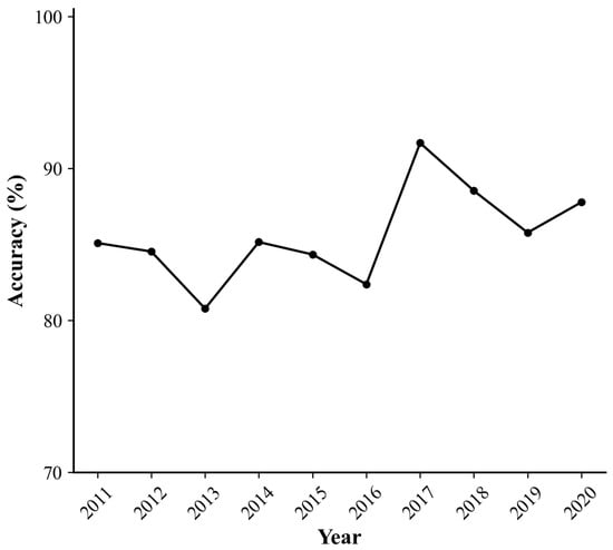
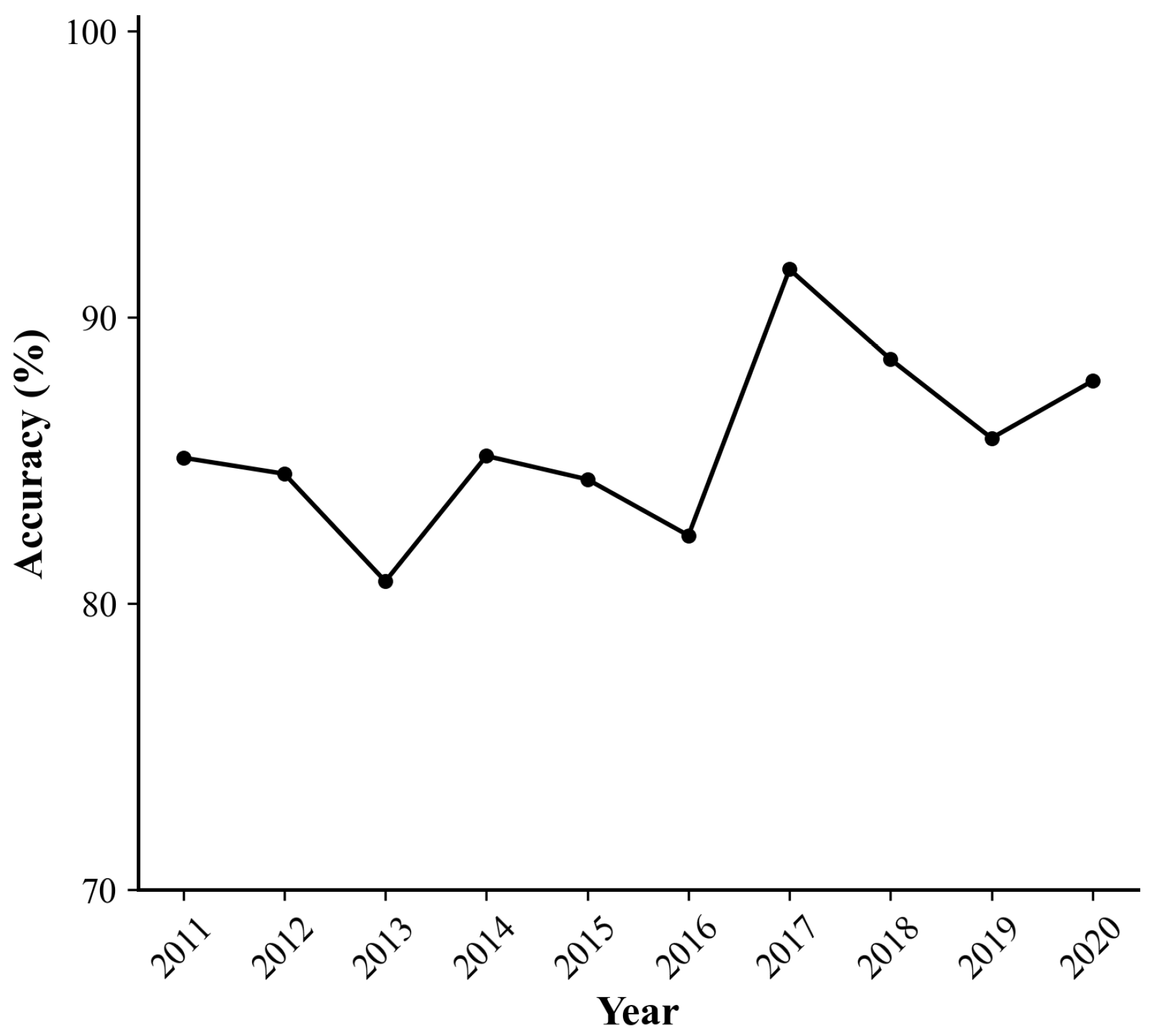
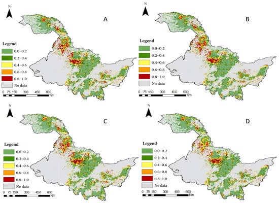
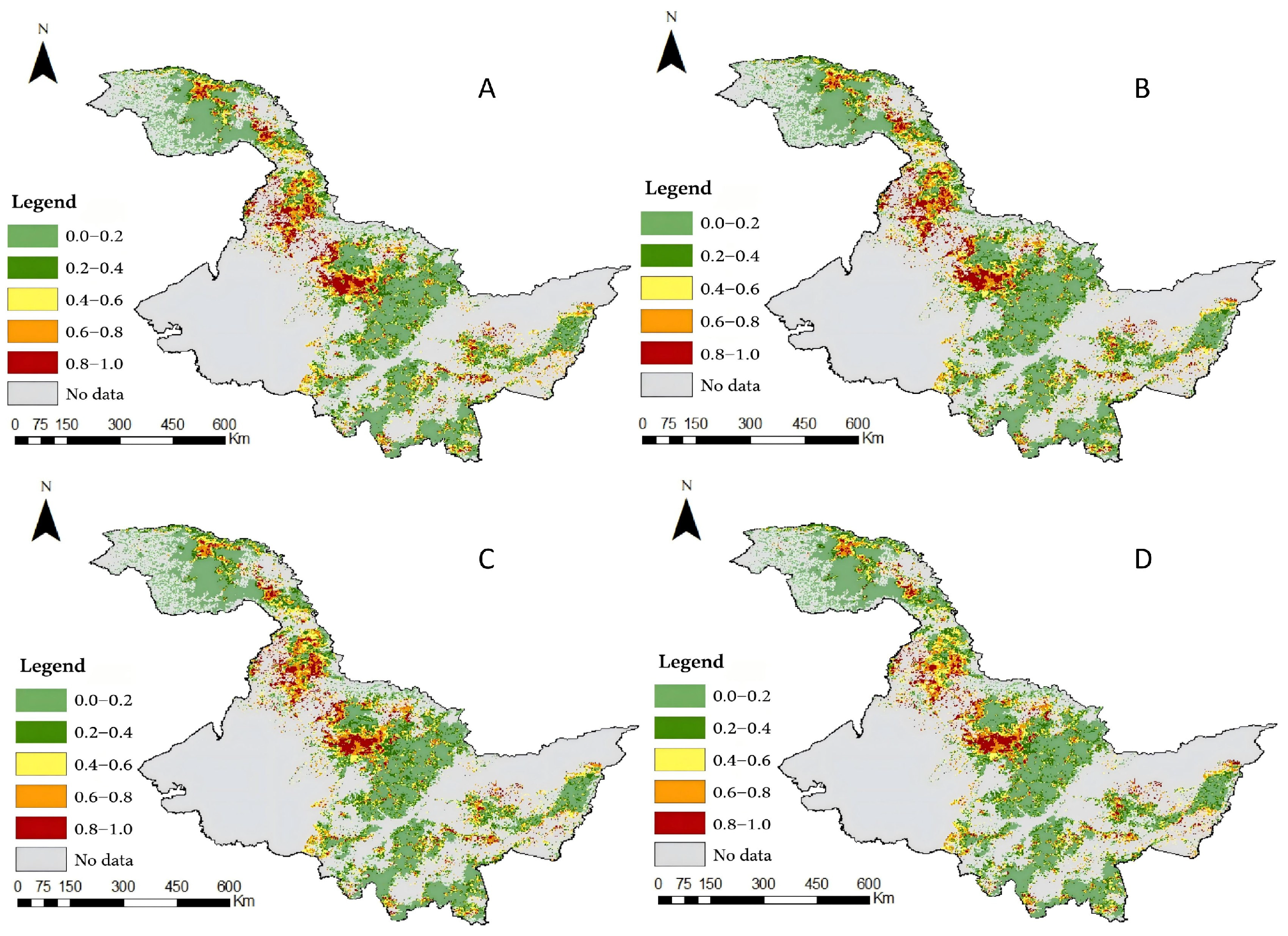
Using ResDNN, the probability and location of forest fire occurrence in the Heilongjiang forest area were predicted. As shown in Figure 6, the model predicts forest fire probability in the study area with good consistency and relative stability. Based on these predictions, fire risk maps were generated. Figure 7 illustrates the spatial distribution of forest fire occurrence probability in Heilongjiang Province for September 2035, predicted under four CMIP6 climate scenarios (SSP1-2.6, SSP2-4.5, SSP3-7.0, and SSP5-8.5, corresponding to Figure 7A–D, respectively). Across all scenarios, the forest fire risk distribution exhibited significant spatial heterogeneity. High-risk areas (indicated by red and deep orange patches) were primarily concentrated in the northern and northwestern parts of the Greater Khingan Mountains forest area, while the southern and eastern regions, where the Lesser Khingan Mountains and Wanda Mountains are located, remained predominantly low-risk (green patches) over time. When comparing different emission scenarios, the coverage and intensity of fire risk areas showed a clear trend of evolution with increasing radiative forcing. Under the low-emission scenario (SSP1-2.6, Figure 7A), high-risk areas were relatively fragmented, confined mainly to the northernmost tip of the study area. As emission intensity increased in the medium scenarios (SSP2-4.5 and SSP3-7.0, Figure 7B,C), the high-risk patches in the north expanded, the connectivity of the medium-high risk transition zone increased, and a southward expansion trend emerged. Under the high-emission scenario (SSP5-8.5, Figure 7D), the predicted fire risk reached the highest level among the four scenarios. The extremely high-risk areas in the northern forest region expanded significantly, the coverage of medium-risk regions increased substantially, and high-probability areas became more spatially continuous, gradually forming a contiguous high-risk belt. This indicates that under extreme climate scenarios, the potential fire threat during the autumn fire prevention period in 2035 will significantly rise.
Figure 6.
Accuracy of ResDNN prediction of annual forest fires from 2011–2020.
Figure 7.
Example of a forest fire risk map for the Heilongjiang forest area in September 2035 generated by the ResDNN model.
3.4. Evolution Trend of Forest Fire Risk Under Future Climate Scenarios
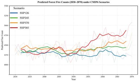
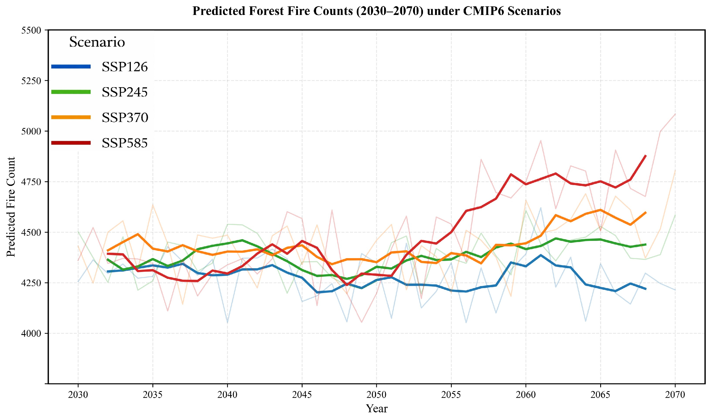
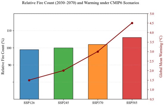
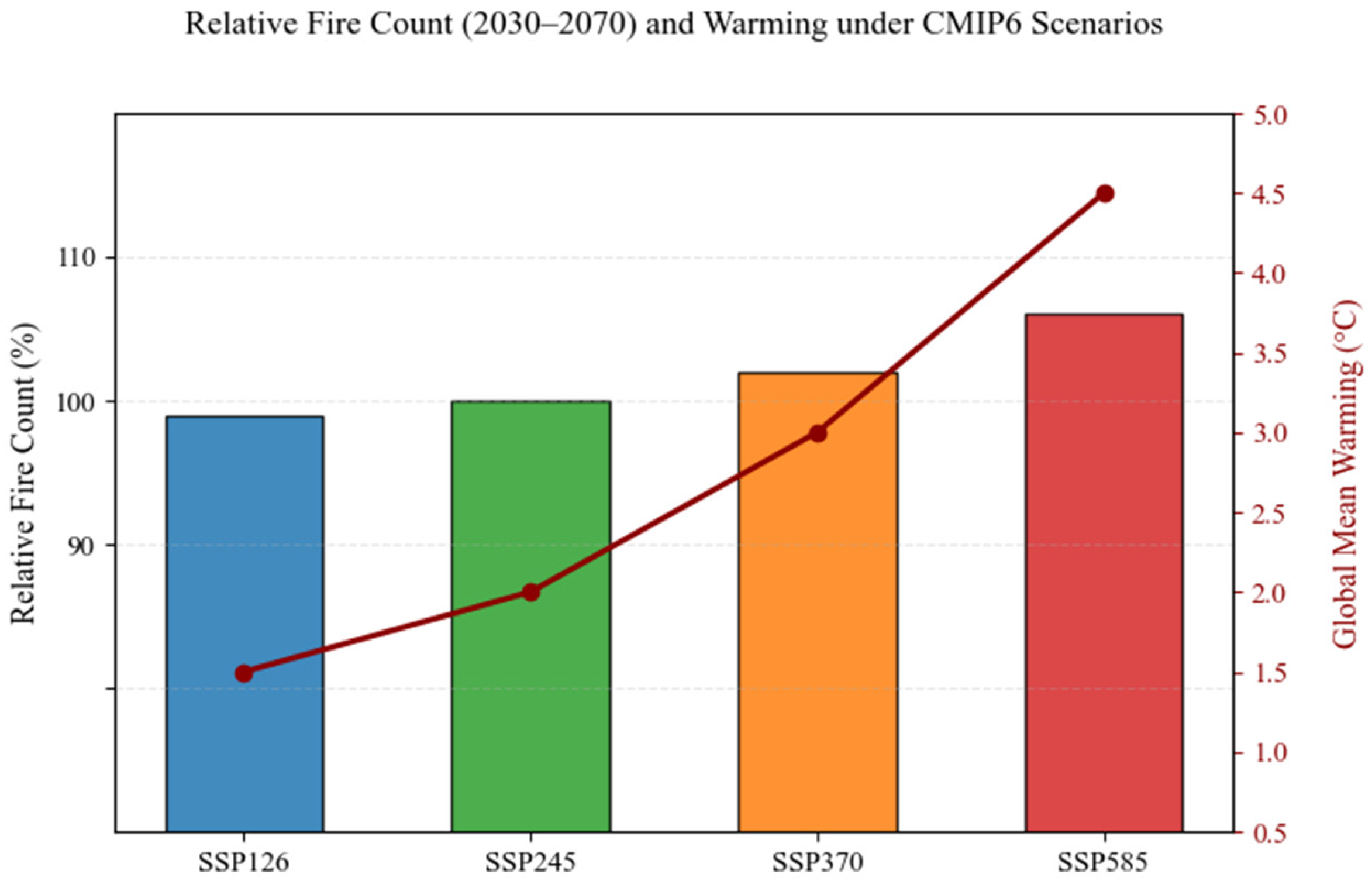
Figure 8 shows the temporal evolution of predicted forest fire occurrence in Heilongjiang Province from 2030 to 2070. To minimize interannual fluctuations within the climate system and emphasize long-term trends, all prediction data were processed using a 5-year moving average. The results indicate that the evolution of fire risk under the four CMIP6 emission scenarios exhibits significant stage-based differentiation. In the early years of the study, fire risk fluctuations across all scenarios were closely synchronized, with a brief numerical trough due to climate oscillations. As the time frame progressed toward the middle of the century, the evolution trajectories under different emission scenarios began to diverge: the number of fire points in the high-emission (SSP5-8.5) and medium-high emission (SSP3-7.0) scenarios showed an accelerated upward trend. By 2070, the predicted number of fire points under the SSP5-8.5 scenario surpassed that of the low-emission scenario (SSP1-2.6) by approximately 15.7%, highlighting the significant influence of high radiative forcing on fire risk. In contrast, the SSP1-2.6 scenario remained near baseline levels, showing no obvious growth trend. Figure 9 displays the cumulative total of high-risk fire points over the entire period, superimposed with the concurrent Global Mean Surface Temperature Anomaly (GMSTA) defined in the IPCC Sixth Assessment Report (AR6). The analysis reveals a strong coupling between the frequency of high-risk fire points and the global warming amplitude, with a clear stepwise increase corresponding to higher radiative forcing (SSP5-8.5 > SSP3-7.0 > SSP2-4.5 > SSP1-2.6). The SSP5-8.5 scenario, associated with the highest expected global warming amplitude, also exhibits the highest total number of high-risk fire points, quantifying the non-linear amplification effect of global warming on regional extreme fire risk events. In contrast, the SSP1-2.6 scenario, with the lowest warming amplitude and high-risk frequency, confirms the significant benefits of proactive climate mitigation measures in reducing extreme fire risks.
Figure 8.
Prediction trend of high-risk forest fire occurrence frequency in Heilongjiang Province under CMIP6 scenarios from 2030–2070. Note: The thick solid lines represent the long-term evolution trend after 5-year moving average processing, while the thin light lines in the background show the original annual simulation data. Different colors correspond to different Shared Socioeconomic Pathway (SSP) scenarios.
Figure 9.
Relative fire count (2030–2070) and warming under CMIP6 scenarios. Note: The figure illustrates the relationship between the relative increase in fire counts and the global mean warming under different SSP scenarios.
4. Discussion
4.1. Major Driving Factors of Forest Fires in China and Their Impacts
This study combined PFI and SHAP to interpret the key driving factors of forest fire occurrence in Heilongjiang Province. The two methods showed a broadly consistent importance pattern, indicating that elevation, Tmin, CMD, RH, and PPT were the dominant variables affecting forest fire occurrence in the study area. This result is consistent with the regional eco-climatic mechanisms underlying fire risk and also suggests that the identified driver structure is relatively stable and reliable.
Elevation and Tmin together defined the basic control framework of forest fire occurrence in the study area. As a comprehensive topographic factor, elevation affects the accumulation and drying process of combustibles by influencing local hydrothermal conditions, snowmelt timing, and vegetation phenology. The SHAP results further showed that lower elevation was more often associated with positive SHAP values, whereas higher elevation tended to show negative contributions, indicating that relatively low-altitude areas are more likely to promote forest fire occurrence, while higher elevation tends to exert a suppressing effect. This is consistent with the findings of Lan et al. [59], who reported that increasing elevation generally weakens forest fire occurrence. Meanwhile, Tmin showed high importance in both PFI and SHAP, and higher Tmin values were more often associated with positive contributions, suggesting that warmer night-time conditions may be more favorable for forest fire occurrence. This is in agreement with Balch et al. [60], who reported that hotter and drier nights weaken the night-time barrier to fire activity and thus increase fire risk. CMD, PPT, and RH formed the second major climatic driver group, further highlighting the key regulatory role of moisture conditions in forest fire occurrence. Among them, RH showed the clearest directional pattern in the SHAP plot: lower RH values were more often associated with positive contributions, whereas higher RH values tended to show negative contributions, indicating that drier atmospheric conditions are more favorable for fire occurrence. By comparison, the directional patterns of CMD and PPT were less clear than that of RH, but both exhibited relatively wide SHAP distributions, suggesting that the effects of moisture-related factors varied across samples rather than acting in a completely uniform way. This result is consistent with the findings of Lan et al. [59], who showed that precipitation and temperature are important climatic factors affecting forest fire occurrence in China and that climate remains the primary driver overall. It also agrees with Wu et al. [61], who found that climate is the primary control on fire occurrence in boreal forest landscapes of northeastern China, while human-related local factors play a secondary role.
The contributions of combustible type (ID) and distance to residential areas (resa_dist), although lower than those of the dominant climatic and topographic factors, were still non-negligible, indicating that fuel properties and human activity play an important supplementary role in shaping the spatial pattern of forest fire occurrence [62]. The SHAP results showed that shorter distances to residential areas, roads, and railways generally corresponded to higher positive contributions, suggesting that forest fire occurrence probability tends to increase near areas with stronger human disturbance. This is consistent with Syphard et al. [63], who found that human presence can become a strong control on fire activity and, to some extent, reduce the apparent dominance of climate.
By contrast, Tmax, Tave, Aspect, and the distances to roads and railways (lrdl_dist/lrrl_dist) showed relatively weak contributions in both PFI and SHAP, indicating limited independent explanatory power in the study area. This may be because part of their information was replaced by more representative dominant factors such as Tmin, Elevation, and moisture-related variables, or because these variables mainly play local or supplementary roles in this region.
4.2. Model Comparison and Evaluation
This study constructed and systematically compared the performance of three models—ResDNN, ANN, and SVM—in predicting forest fire occurrence probability in Heilongjiang Province. As shown in Table 2, the ResDNN model outperformed both ANN and SVM across all evaluation metrics. Its prediction accuracy was the highest (85.6%), surpassing ANN (81.5%) and SVM (77.8%) by approximately 4.1 and 7.8 percentage points, respectively. Additionally, ResDNN achieved the highest AUC value (0.908) and recall rate (90.3%), maintaining a lead in precision and F1 score. These results demonstrate that ResDNN not only offers superior comprehensive discrimination robustness but is also highly sensitive to the identification of actual fire points, significantly reducing the risk of missed reports. This makes it highly valuable for real-world early warning applications. The findings suggest the advantages of deep learning methods in forest fire prediction tasks involving complex geographic environments and multi-factor interactions.
The comprehensive leadership of the ResDNN model across various indicators can be attributed to its deep architecture and advanced learning mechanism. Compared to traditional shallow machine learning models, ResDNN better adapts to the highly non-linear and multi-scale interactive data characteristics inherent in forest fire prediction. First, its superior accuracy and AUC values reflect the model’s exceptional overall classification ability and class discrimination. Forest fire occurrence results from the non-linear combination of multiple factors, such as topography, climate, vegetation, and human activities. Traditional shallow models like ANN encounter bottlenecks in feature interaction, whereas SVM, while capable of mapping to high-dimensional space via kernel functions, depends heavily on the correct selection of kernel functions and parameters. Additionally, SVM struggles to learn multi-level feature representations automatically. ResDNN, leveraging its deep stacked non-linear transformations and Residual Connections mechanism, automatically extracts hierarchical representations, from low-level environmental features to high-level fire risk patterns, allowing it to more precisely model the complex boundaries of fire occurrence. This finding aligns with recent studies, such as Lai et al., who compared DNN with ANN and SVM in forest fire prediction and found that DNN, due to its deep feature learning capabilities, achieved higher accuracy and AUC values when handling imbalanced data and complex patterns [64]. The ConvLSTM model proposed by Prapas et al. also significantly outperformed traditional methods like random forests in generating high-resolution fire risk maps, further confirming the potential of deep learning in spatiotemporal prediction tasks [33].
Moreover, the exceptional recall rate (90.3%) of ResDNN indicates its strong ability to capture positive examples (fire events). In forest fire prevention and control, minimizing the rate of missed reports is essential. The high recall rate of ResDNN is due to its effective learning of discriminative features of fire events via deep networks and Dropout regularization, which reduces the neglect of minority class samples. In contrast, ANN and SVM may struggle with insufficient feature learning for minority classes (fire points) under complex sample distributions, resulting in relatively lower recall rates. This advantage aligns with Zheng et al., who demonstrated that their improved DCNN model significantly enhanced fire recognition sensitivity and recall performance through transfer learning and feature enhancement [35]. Additionally, the balanced and strong performance of ResDNN in precision and F1 score shows that, while it identifies as many real fire points as possible, it also effectively controls the false alarm rate, ensuring the reliability of prediction results. This balance arises from ResDNN’s ability to adaptively optimize the classification decision boundary through end-to-end training, whereas traditional models like SVM often require complex sample weighting or threshold adjustments to address class imbalance.
The comparative experiments in this study clearly demonstrate that in Heilongjiang Province, a region characterized by complex environmental factors and diverse fire risk drivers, the ResDNN model outperforms traditional machine learning models such as ANN and SVM. This superiority is attributed to its deep non-linear fitting capability, automatic feature learning, and effective handling of imbalanced data. This conclusion aligns with the global trend of using deep learning to enhance fire prediction accuracy [35,54] and provides a solid foundation for selecting fire prediction models in high-latitude forest areas of China. Consequently, the optimized ResDNN model, combined with climate scenario data from four Shared Socioeconomic Pathways (SSP1-2.6, SSP2-4.5, SSP3-7.0, SSP5-8.5) provided by CMIP6, was employed to conduct monthly, high-resolution simulations and mappings of the spatiotemporal probability of forest fire occurrence in Heilongjiang Province from 2030 to 2070.
4.3. Analysis of Future Fire Risk Prediction Results
Using the optimized ResDNN model, this study first conducted retrospective predictions and verifications of forest fire occurrence probability in Heilongjiang’s forest area for the historical period (2011–2020). As shown in Figure 6, the model maintained high and stable prediction accuracy throughout the verification period, with minimal annual fluctuations. This consistent performance demonstrates that the model reliably captures the interannual variation in fire occurrence, rather than overfitting to random fluctuations. Its ability to accurately reproduce historical data provides a strong foundation for future predictions under different climate scenarios. The model’s stable historical performance confirms its robustness in capturing region-specific climate–fire dynamics. This proven temporal generalization justifies its application for projecting long-term fire risks under future SSP scenarios.
Based on this, the study further generated spatial distribution maps of forest fire risk probability for September 2035 under four CMIP6 scenarios (Figure 7). The prediction results clearly reveal a significant spatial heterogeneity pattern, characterized by “high in the north and low in the south, high in the west and low in the east”. High fire risk areas are consistently clustered in the northern and northwestern parts of the Greater Khingan Mountains, while the risk in the southern and eastern regions, where the Lesser Khingan Mountains and Wanda Mountains are located, remains relatively low. This spatial pattern arises from the combined influence of regional climate, topography, vegetation, and human activities. The northern Greater Khingan Mountains region, at a higher latitude, is more strongly impacted by the continental climate, with dry, windy conditions in spring and autumn. Vegetation here is predominantly flammable coniferous forests (such as Hinggan larch), and the forest floor has high fuel loads. Additionally, human disturbances, such as lightning fires and some production-related fire use, are relatively frequent in this area. In contrast, the southern and eastern regions are slightly more influenced by the monsoon, with more favorable hydrothermal conditions, a higher proportion of broad-leaved trees in the vegetation, and possibly more intensive and effective fire prevention management. The north–south and west–east fire risk gradients closely align with the findings of Wang et al. [65], who identified spatial fire risk differentiation in Northeast China’s forest areas. Their study also highlighted the Greater Khingan Mountains as the core area with the highest fire risk in the region and emphasized the critical roles of drought index and vegetation type.
The temporal prediction results in Figure 8 and Figure 9 reveal distinct divergences under different emission scenarios, highlighting the significant impact of increasing greenhouse gas concentrations and global warming on fire activity. Overall, both the frequency and intensity of fire events rise substantially with higher greenhouse gas emissions. Particularly under the SSP5-8.5 high emission scenario, the predicted number of fire points in 2070 is approximately 15.7% higher than under the low emission scenario (SSP1-2.6). Additionally, the cumulative number of high-risk fire points shows a strict positive correlation with the GMSTA, confirming the core conclusion of the IPCC AR6 report, which states that global warming will significantly increase the frequency and intensity of extreme fire weather in many regions [66]
Notably, despite the overall upward trend, the prediction sequences for all scenarios exhibit a relative peak around 2058, with smaller troughs around 2048 and 2066. These decadal-scale fluctuations are likely linked to the inherent natural variability within the climate system, such as phase transitions in sea surface temperature modes like the Pacific Decadal Oscillation (PDO) or Atlantic Multidecadal Oscillation (AMO). These modes can influence regional precipitation and temperature patterns by modulating atmospheric circulation, thereby driving decadal fluctuations in fire activity. Flannigan et al., in their review on climate change and forest fires, emphasized that while long-term anthropogenic climate change trends are critical, the superimposed effects of natural climate variability on interannual and interdecadal fire activity fluctuations must also be considered [25]. The fluctuations predicted by this model likely reflect such internal climate system variability, as captured by the CMIP6 MME data. This indicates that the prediction results are not simple monotonic extrapolations but include the complex dynamics of the climate system. Furthermore, it suggests that future fire prevention resource planning should not only account for the long-term upward trend but also prepare for stage-based “active periods” and “quiet periods” of fire risk driven by natural climate variability.
In summary, the future prediction component of this study not only identifies the high-risk core areas and stable regions of Heilongjiang Province spatially but also quantifies the potential fire risk increase associated with different climate policy paths (represented by SSP scenarios) over time. The spatiotemporal pattern predicted by the model aligns with existing ecological and climate understanding, while the climate variability signals it uncovers add complexity and realism to the prediction results. These findings provide a scientific foundation, incorporating both macro trends and detailed fluctuations, to help Heilongjiang Province develop differentiated, forward-looking long-term forest fire prevention and control strategies to adapt to climate change. At the same time, this study acknowledges certain limitations and offers directions for future research. Firstly, it does not account for the “non-stationarity” impacts that could arise from vegetation community succession, significant land use changes, or major adjustments in fire prevention policies. Moreover, the predictor variables used in this study were derived from datasets with different spatial and temporal resolutions and were harmonized to a common 1 km monthly grid before modeling. This preprocessing is necessary for regional-scale analysis and helps ensure data consistency, while a certain degree of uncertainty may still remain in the final predictions. Secondly, the future meteorological inputs used in this study were derived from the downscaled CMIP6 multi-model ensemble, which is helpful for representing the overall trend of future climate change. However, the variability among individual climate models was not further distinguished in the present analysis, and uncertainties in future climate projections still remain. Future research could further compare the projections of different CMIP6 models and provide a more systematic assessment of the uncertainties arising from inter-model variability. In addition, dynamic vegetation models could be incorporated to achieve a closed-loop simulation of the “climate–vegetation–fire” interaction, thus creating a more comprehensive fire risk projection system.
5. Conclusions
Compared with previous studies on boreal forest ecosystems and global forest fire prediction, existing research has mainly focused on identifying present-day fire-occurrence patterns or has relied primarily on conventional statistical and shallow-learning methods, with relatively limited attention to the spatiotemporal evolution of fire risk under future scenarios. Against this background, the present study not only identifies the current fire-risk pattern, but also extends the analysis to future fire-risk change under different SSPs. Meanwhile, the results indicate that ResDNN is well suited to describing the complex nonlinear relationships among climatic, topographic, human, and vegetation-related factors. Therefore, the contribution of this study is both methodological and application-based, as it not only provides practical support for regional fire-risk assessment and future scenario analysis, but also demonstrates the usefulness of deep learning in complex forest fire modeling.
This study combined PFI and SHAP to provide an integrated interpretation of the key driving factors of forest fire occurrence in Heilongjiang Province. The results reveal that meteorological, topographic, human, and vegetation factors are core elements influencing the spatial distribution and occurrence probability of forest fires, with meteorological factors exerting the most significant influence. Based on this research framework, three forest fire prediction models—ResDNN, ANN, and SVM—were constructed and compared. Model evaluation results show that all three models achieved overall prediction accuracy exceeding 75%, demonstrating high applicability and stability. Among them, the ResDNN model exhibited the best comprehensive prediction performance, with an accuracy of 85.6%, showing stronger capability in non-linear feature learning and multi-dimensional factor interaction identification. Therefore, ResDNN was identified as the optimal model for forest fire risk prediction in this study area.
Building on this, the ResDNN model was utilized to simulate and predict the probability of forest fire occurrence in the Heilongjiang forest area from 2030 to 2070. By integrating the input variables from four CMIP6 climate scenarios (SSP126, SSP245, SSP370, SSP585), probability maps of forest fire spatial distribution under different future climate conditions were generated. The results indicate that, under the combined effects of climate warming and changes in dryness and humidity, high-risk forest fire areas are primarily located in the southern section of the Lesser Khingan Mountains, the southern foothills of the Greater Khingan Mountains, and the Zhangguangcai Mountains. These high-risk areas gradually expand with increasing warming amplitudes of the climate scenarios. Based on the above predictions, this study further classified high-risk and low-risk forest fire areas and proposed corresponding prevention, control, and management strategies for each risk level, thereby providing a scientific basis for regional fire prevention planning and resource allocation. More importantly, the differences among SSP scenarios suggest that forest fire management in Heilongjiang Province should not follow a uniform strategy: under lower-emission scenarios, prevention efforts can remain focused on the existing high-risk core areas, whereas under higher-emission scenarios, monitoring, fuel management, and firefighting resource allocation should be strengthened in advance in areas where fire risk is projected to increase. This also indicates that differences in fire-risk change under future scenarios can provide a basis for differentiated fire prevention planning and climate adaptation decision-making.
In conclusion, this study highlights the advantages and practical potential of deep learning methods in forest fire risk mapping and future scenario forecasting under complex environmental conditions. The research findings offer a quantitative basis for Heilongjiang Province—particularly high-risk areas like the Greater Khingan Mountains—to develop differentiated, forward-looking long-term forest fire prevention and control strategies, as well as climate change adaptation plans. Future research can focus on coupling dynamic vegetation models, incorporating higher-resolution socioeconomic scenarios, and quantifying the uncertainties in climate predictions to further enhance the prediction system. This will support precise forest resource management and ecological security. Additionally, integrating dynamic climate data and real-time monitoring information into the model could create a multi-temporal, updatable fire prediction system, improving its timeliness and adaptability to climate change.
Author Contributions
Conceptualization, M.L.; Methodology, Z.W. and H.L.; Software, Z.W.; Validation, Y.T.; Investigation, X.M.; Resources, M.L.; Data curation, M.L. and H.L.; Formal analysis, Z.W. and H.L.; Writing—original draft preparation, Z.W. and H.L.; Writing—review & editing, X.M. and Y.Z.; Visualization, Y.Q.; Supervision, Y.Q. and J.L.; Project administration, H.L.; Funding acquisition, M.L. All authors have read and agreed to the published version of the manuscript.
Funding
This research was funded by the Science and Technology Department of Heilongjiang Province (No. QC2025C016) and the Heilongjiang Provincial Department of Human Resources and Social Security (No. LBH-Z25056).
Data Availability Statement
The authors do not have permission to share data.
Acknowledgments
We would like to thank Kai Liu from the Heilongjiang Academy of Forestry for his valuable support in data collection and research assistance.
Conflicts of Interest
The authors declare that they have no known competing financial interests or personal relationships that could have appeared to influence the work reported in this paper.
References
- He, T.; Lamont, B.B. Baptism by fire: The pivotal role of ancient conflagrations in evolution of the Earth’s flora. Natl. Sci. Rev. 2018, 5, 237–254. [Google Scholar] [CrossRef]
- Robinne, F.-N.; Burns, J.; Kant, P.; Flannigan, M.D.; Kleine, M.; de Groot, W.J.; Wotton, B.M. Global Fire Challenges in a Warming World; IUFRO: Vienna, Austria, 2018. [Google Scholar]
- Liu, Z.; Ballantyne, A.P.; Cooper, L.A. Biophysical feedback of global forest fires on surface temperature. Nat. Commun. 2019, 10, 214. [Google Scholar] [CrossRef] [PubMed]
- Wang, J.A.; Baccini, A.; Farina, M.; Randerson, J.T.; Friedl, M.A. Disturbance suppresses the aboveground carbon sink in North American boreal forests. Nat. Clim. Change 2021, 11, 435–441. [Google Scholar] [CrossRef]
- Pechony, O.; Shindell, D.T. Driving forces of global wildfires over the past millennium and the forthcoming century. Proc. Natl. Acad. Sci. USA 2010, 107, 19167–19170. [Google Scholar] [CrossRef] [PubMed]
- Cisneros, R.; Schweizer, D.; Tarnay, L.; Navarro, K.; Veloz, D.; Procter, C.T. Climate change, forest fires, and health in California. In Climate Change and Air Pollution: The Impact on Human Health in Developed and Developing Countries; Springer: Cham, Switzerland, 2017; pp. 99–130. [Google Scholar] [CrossRef]
- Zhang, Y.; Qin, D.; Yuan, W.; Jia, B. Historical trends of forest fires and carbon emissions in China from 1988 to 2012. J. Geophys. Res. Biogeosci. 2016, 121, 2506–2517. [Google Scholar] [CrossRef]
- Mahalingam, S.; Deep, M.S.; Krishna, K.S. Wireless Sensor Based Forest Fire Early Detection with Online Remote Monitoring. Int. J. Eng. Adv. Technol 2021, 10, 143–145. [Google Scholar] [CrossRef]
- Fried, J.S.; Gilless, J.K.; Riley, W.J.; Moody, T.J.; Simon de Blas, C.; Hayhoe, K.; Moritz, M.; Stephens, S.; Torn, M. Predicting the effect of climate change on wildfire behavior and initial attack success. Clim. Change 2008, 87, 251–264. [Google Scholar] [CrossRef]
- Fried, J.S.; Torn, M.S.; Mills, E. The impact of climate change on wildfire severity: A regional forecast for northern California. Clim. Change 2004, 64, 169–191. [Google Scholar] [CrossRef]
- Wang, Y.Q.; Wang, Y.L.; Guo, X.B.; Sun, Y.M. Forest Fire Risk Prediction Based on Direct-Connected BP Neural Network Model. For. Fire Prev. 2018, 2, 41–45. [Google Scholar]
- Jones, M.W.; Smith, A.J.P.; Betts, R.; Canadell, J.G.; Prentice, I.C.; Le Quéré, C. Climate Change Increases the Risk of Wildfires. 2020. Available online: https://sciencebrief.org/uploads/reviews/ScienceBrief_Review_WILDFIRES_Jan2020.pdf (accessed on 30 June 2025).
- Guo, F.; Su, Z.; Wang, G.; Sun, L.; Tigabu, M.; Yang, X.; Hu, H. Understanding fire drivers and relative impacts in different Chinese forest ecosystems. Sci. Total Environ. 2017, 605, 411–425. [Google Scholar] [CrossRef]
- Peng, W.; Wei, Y.; Chen, G.; Lu, G.; Ye, Q.; Ding, R.; Hu, P.; Cheng, Z. Analysis of wildfire danger level using logistic regression model in Sichuan Province, China. Forests 2023, 14, 2352. [Google Scholar] [CrossRef]
- Zhang, F.; Zhang, B.; Luo, J.; Liu, H.; Deng, Q.; Wang, L.; Zuo, Z. Forest fire driving factors and fire risk zoning based on an optimal parameter logistic regression model: A case study of the Liangshan Yi Autonomous Prefecture, China. Fire 2023, 6, 336. [Google Scholar] [CrossRef]
- Brillinger, D.R.; Preisler, H.K.; Benoit, J.W. Probabilistic risk assessment for wildfires. Environmetrics 2006, 17, 623–633. [Google Scholar] [CrossRef]
- Goldarag, Y.J.; Mohammadzadeh, A.; Ardakani, A.S. Fire risk assessment using neural network and logistic regression. J. Indian Soc. Remote Sens. 2016, 44, 885–894. [Google Scholar] [CrossRef]
- Guo, F.; Zhang, L.; Jin, S.; Tigabu, M.; Su, Z.; Wang, W. Modeling anthropogenic fire occurrence in the boreal forest of China using logistic regression and random forests. Forests 2016, 7, 250. [Google Scholar] [CrossRef]
- Guo, F.; Wang, G.; Su, Z.; Liang, H.; Liu, A. What drives forest fire in Fujian, China? Evidence from logistic regression and Random Forests. Int. J. Wildland Fire 2016, 25, 505–519. [Google Scholar] [CrossRef]
- Dimopoulou, M.; Giannikos, I. Towards an integrated framework for forest fire control. Eur. J. Oper. Res. 2004, 152, 476–486. [Google Scholar] [CrossRef]
- Epifanio, I. Intervention in prediction measure: A new approach to assessing variable importance for random forests. BMC Bioinform. 2017, 18, 230. [Google Scholar] [CrossRef]
- Erten, E.; Kurgun, V.; Musaoglu, N. Forest fire risk zone mapping from satellite imagery and GIS: A case study. In Proceedings of the XXth Congress of the International Society for Photogrammetry and Remote Sensing, Istanbul, Turkey, 12–23 July 2004. [Google Scholar]
- Börlin, N.; Grussenmeyer, P.; Eriksson, J.; Lindström, P. Geo-imagery bridging continents. In Proceedings of the XXth ISPRS Congress, Istanbul, Turkey, 12–23 July 2004. [Google Scholar]
- Guo, F.-T.; Hu, H.-Q.; Jin, S.; Ma, H.-Z.; Zhang, Y. Relationship between forest lighting fire occurrence and weather factors in Daxing’an Mountains based on negative binomial model and zero-inflated negative binomial models. Chin. J. Plant Ecol. 2010, 34, 571–577. [Google Scholar]
- Flannigan, M.D.; Krawchuk, M.A.; de Groot, W.J.; Wotton, B.M.; Gowman, L.M. Implications of changing climate for global wildland fire. Int. J. Wildland Fire 2009, 18, 483–507. [Google Scholar] [CrossRef]
- Guo, F.; Selvalakshmi, S.; Lin, F.; Wang, G.; Wang, W.; Su, Z.; Liu, A. Geospatial information on geographical and human factors improved anthropogenic fire occurrence modeling in the Chinese boreal forest. Can. J. For. Res. 2016, 46, 582–594. [Google Scholar] [CrossRef]
- Yang, S.; Lupascu, M.; Meel, K.S. Predicting forest fire using remote sensing data and machine learning. In Proceedings of the AAAI Conference on Artificial Intelligence, Virtual, 2–9 February 2021. [Google Scholar] [CrossRef]
- McNorton, J.R.; Di Giuseppe, F.; Pinnington, E.M.; Chantry, M.; Barnard, C. A global probability-of-fire (PoF) forecast. Geophys. Res. Lett. 2024, 51, e2023GL107929. [Google Scholar] [CrossRef]
- Parks, S.A.; Holsinger, L.M.; Panunto, M.H.; Jolly, W.M.; Dobrowski, S.Z.; Dillon, G.K. High-severity fire: Evaluating its key drivers and mapping its probability across western US forests. Environ. Res. Lett. 2018, 13, 044037. [Google Scholar] [CrossRef]
- Cortez, P.; Morais, A.D.J.R. A data mining approach to predict forest fires using meteorological data. In Proceedings of the 13th Portuguese Conference on Artificial Intelligence (EPIA 2007), Guimarães, Portugal, 3–7 December 2007. [Google Scholar]
- Sakr, G.E.; Elhajj, I.H.; Mitri, G. Efficient forest fire occurrence prediction for developing countries using two weather parameters. Eng. Appl. Artif. Intell. 2011, 24, 888–894. [Google Scholar] [CrossRef]
- Kondylatos, S.; Prapas, I.; Ronco, M.; Papoutsis, I.; Camps-Valls, G.; Piles, M.; Fernández-Torres, M.-Á.; Carvalhais, N. Wildfire danger prediction and understanding with deep learning. Geophys. Res. Lett. 2022, 49, e2022GL099368. [Google Scholar] [CrossRef]
- Prapas, I.; Kondylatos, S.; Papoutsis, I.; Camps-Valls, G.; Ronco, M.; Fernández-Torres, M.-Á.; Piles, M.; Carvalhais, N. Deep learning methods for daily wildfire danger forecasting. arXiv 2021, arXiv:2111.02736. [Google Scholar] [CrossRef]
- Pang, B.; Cheng, S.; Huang, Y.; Jin, Y.; Guo, Y.; Prentice, I.C.; Harrison, S.P.; Arcucci, R. Fire-Image-DenseNet (FIDN) for predicting wildfire burnt area using remote sensing data. Comput. Geosci. 2025, 195, 105783. [Google Scholar] [CrossRef]
- Zheng, S.; Gao, P.; Wang, W.; Zou, X. A highly accurate forest fire prediction model based on an improved dynamic convolutional neural network. Appl. Sci. 2022, 12, 6721. [Google Scholar] [CrossRef]
- Zhang, L.; Wang, M.; Fu, Y.; Ding, Y. A forest fire recognition method using UAV images based on transfer learning. Forests 2022, 13, 975. [Google Scholar] [CrossRef]
- Satir, O.; Berberoglu, S.; Donmez, C. Mapping regional forest fire probability using artificial neural network model in a Mediterranean forest ecosystem. Geomat. Nat. Hazards Risk 2016, 7, 1645–1658. [Google Scholar] [CrossRef]
- Ku, C.-Y.; Liu, C.-Y. Predictive modeling of fire incidence using deep neural networks. Fire 2024, 7, 136. [Google Scholar] [CrossRef]
- Zhang, G.; Wang, M.; Liu, K. Forest fire susceptibility modeling using a convolutional neural network for Yunnan province of China. Int. J. Disaster Risk Sci. 2019, 10, 386–403. [Google Scholar] [CrossRef]
- Glorot, X.; Bengio, Y. Understanding the difficulty of training deep feedforward neural networks. In Proceedings of the Thirteenth International Conference on Artificial Intelligence and Statistics, Sardinia, Italy, 13–15 May 2010. [Google Scholar]
- He, K.; Zhang, X.; Ren, S.; Sun, J. Deep residual learning for image recognition. In Proceedings of the IEEE Conference on Computer Vision and Pattern Recognition, Las Vegas, NV, USA, 26 June–1 July 2016. [Google Scholar] [CrossRef]
- Bradstock, R.A. A biogeographic model of fire regimes in Australia: Current and future implications. Glob. Ecol. Biogeogr. 2010, 19, 145–158. [Google Scholar] [CrossRef]
- Wu, Z.; Li, M.; Wang, B.; Quan, Y.; Liu, J. Using artificial intelligence to estimate the probability of forest fires in Heilongjiang, northeast China. Remote Sens. 2021, 13, 1813. [Google Scholar] [CrossRef]
- Wang, M.; Si, L.; Chen, F.; Shu, L.; Zhao, F.; Li, W. Simulation of Fire Occurrence Based on Historical Data in Future Climate Scenarios and Its Practical Verification. Fire 2024, 7, 346. [Google Scholar] [CrossRef]
- Li, Y.; Xu, S.; Fan, Z.; Zhang, X.; Yang, X.; Wen, S.; Shi, Z. Risk Factors and Prediction of the Probability of Wildfire Occurrence in the China–Mongolia–Russia Cross-Border Area. Remote Sens. 2023, 15, 42. [Google Scholar] [CrossRef]
- Jones, M.W.; Abatzoglou, J.T.; Veraverbeke, S.; Andela, N.; Lasslop, G.; Forkel, M.; Smith, A.J.P.; Burton, C.; Betts, R.A.; van der Werf, G.R.; et al. Global and regional trends and drivers of fire under climate change. Rev. Geophys. 2022, 60, e2020RG000726. [Google Scholar] [CrossRef]
- Abatzoglou, J.T.; Williams, A.P. Impact of anthropogenic climate change on wildfire across western US forests. Proc. Natl. Acad. Sci. USA 2016, 113, 11770–11775. [Google Scholar] [CrossRef]
- Dillon, G.K.; Holden, Z.A.; Morgan, P.; Crimmins, M.A.; Heyerdahl, E.K.; Luce, C.H. Both topography and climate affected forest and woodland burn severity in two regions of the western US, 1984 to 2006. Ecosphere 2011, 2, 130. [Google Scholar] [CrossRef]
- Westerling, A.L.; Hidalgo, H.G.; Cayan, D.R.; Swetnam, T.W. Warming and earlier spring increase western US forest wildfire activity. Science 2006, 313, 940–943. [Google Scholar] [CrossRef]
- Holden, Z.A.; Jolly, W.M. Modeling topographic influences on fuel moisture and fire danger in complex terrain to improve wildland fire management decision support. For. Ecol. Manag. 2011, 262, 2133–2141. [Google Scholar] [CrossRef]
- Syphard, A.D.; Radeloff, V.C.; Keeley, J.E.; Hawbaker, T.J.; Clayton, M.K.; Stewart, S.I.; Hammer, R.B. Human influence on California fire regimes. Ecol. Appl. 2007, 17, 1388–1402. [Google Scholar] [CrossRef] [PubMed]
- Narayanaraj, G.; Wimberly, M.C. Influences of forest roads on the spatial patterns of human-and lightning-caused wildfire ignitions. Appl. Geogr. 2012, 32, 878–888. [Google Scholar] [CrossRef]
- Rogers, B.M.; Soja, A.J.; Goulden, M.L.; Randerson, J.T. Influence of tree species on continental differences in boreal fires and climate feedbacks. Nat. Geosci. 2015, 8, 228–234. [Google Scholar] [CrossRef]
- Jain, P.; Coogan, S.C.P.; Subramanian, S.G.; Crowley, M.; Taylor, S.; Flannigan, M.D. A review of machine learning applications in wildfire science and management. Environ. Rev. 2020, 28, 478–505. [Google Scholar] [CrossRef]
- Xu, Q.; Li, W.; Liu, J.; Wang, X. A geographical similarity-based sampling method of non-fire point data for spatial prediction of forest fires. For. Ecosyst. 2023, 10, 100104. [Google Scholar] [CrossRef]
- Rew, J.; Cho, Y.; Hwang, E. A Robust Prediction Model for Species Distribution Using Bagging Ensembles with Deep Neural Networks. Remote Sens. 2021, 13, 1495. [Google Scholar] [CrossRef]
- Srivastava, N.; Hinton, G.; Krizhevsky, A.; Sutskever, I.; Salakhutdinov, R. Dropout: A simple way to prevent neural networks from overfitting. J. Mach. Learn. Res. 2014, 15, 1929–1958. [Google Scholar]
- Goodfellow, I.; Bengio, Y.; Courville, A. Deep Learning; MIT Press: Cambridge, MA, USA, 2016. [Google Scholar]
- Lan, Z.; Su, Z.; Guo, M.; Alvarado, E.C.; Guo, F.; Hu, H.; Wang, G. Are Climate Factors Driving the Contemporary Wildfire Occurrence in China? Forests 2021, 12, 392. [Google Scholar] [CrossRef]
- Balch, J.K.; Abatzoglou, J.T.; Joseph, M.B.; Koontz, M.J.; Mahood, A.L.; McGlinchy, J.; Cattau, M.E.; Williams, A.P. Warming weakens the night-time barrier to global fire. Nature 2022, 602, 442–448. [Google Scholar] [CrossRef]
- Wu, Z.; He, H.S.; Yang, J.; Liu, Z.; Liang, Y. Relative effects of climatic and local factors on fire occurrence in boreal forest landscapes of northeastern China. Sci. Total Environ. 2014, 493, 472–480. [Google Scholar] [CrossRef]
- Maingi, J.K.; Henry, M.C. Factors influencing wildfire occurrence and distribution in eastern Kentucky, USA. Int. J. Wildland Fire 2007, 16, 23–33. [Google Scholar] [CrossRef]
- Syphard, A.D.; Keeley, J.E.; Pfaff, A.H.; Ferschweiler, K. Human presence diminishes the importance of climate in driving fire activity across the United States. Proc. Natl. Acad. Sci. USA 2017, 114, 13750–13755. [Google Scholar] [CrossRef]
- Lai, C.; Zeng, S.; Guo, W.; Liu, X.; Li, Y.; Liao, B. Forest fire prediction with imbalanced data using a deep neural network method. Forests 2022, 13, 1129. [Google Scholar] [CrossRef]
- Wang, A.; Zhang, D.; Feng, Z.; Li, X.; Li, X. Spatiotemporal Patterns and Risk Zoning of Wildfire Occurrences in Northeast China from 2001 to 2019. Forests 2023, 14, 2350. [Google Scholar] [CrossRef]
- IPCC. Climate Change 2021: The Physical Science Basis. Contribution of Working Group I to the Sixth Assessment Report of the Intergovernmental Panel on Climate Change; Cambridge University Press: Cambridge, UK, 2021. [Google Scholar] [CrossRef]

Disclaimer/Publisher’s Note: The statements, opinions and data contained in all publications are solely those of the individual author(s) and contributor(s) and not of MDPI and/or the editor(s). MDPI and/or the editor(s) disclaim responsibility for any injury to people or property resulting from any ideas, methods, instructions or products referred to in the content. |
© 2026 by the authors. Licensee MDPI, Basel, Switzerland. This article is an open access article distributed under the terms and conditions of the Creative Commons Attribution (CC BY) license.