


Abstract
Early-spring ephemeral plants constitute a dominant photosynthetic functional group during the critical early-spring moisture window (March–April) in the desert ecosystems of Xinjiang. They provide the primary energy base for pollinators and granivores and stabilize soils before perennial vegetation is activated. Despite this foundational role, their conservation status within protected areas (PAs) under changing climatic scenarios remains unquantified. This study aims to assess the current and future distribution of Brassicaceae early-spring ephemeral plants and evaluate the effectiveness of the current nature-reserve network in Xinjiang. Using 91 occurrence records and five environmental variables, we applied MaxEnt species distribution modeling (AUC = 0.917 ± 0.023) combined with spatial overlap analysis to quantify suitable habitats within PAs under current and future (2050s and 2070s) climate scenarios. Precipitation during the driest month (Bio14, 83.8%) was the most influential predictor in the model, followed by mean annual temperature (Bio1, 5.7%) and annual precipitation (Bio12, 5.4%). Under current climatic conditions, the total suitable area was 423,500 km2 (25.4% of Xinjiang), with high-suitability habitats (125,571 km2) concentrated along the northern Tian Shan piedmont. However, only 28,349 km2 (6.7%) of the total suitable area and 5640 km2 (4.5%) of the high-suitability zone fall within the 18 analyzed nature reserves. Under climate scenarios for the 2050s and 2070s, the total suitable area was projected to expand by 11.6–15.8%, but the high-suitability habitat within the analyzed nature reserves was predicted to collapse by 88–92%, as newly emerging suitable areas are projected to occur almost entirely outside their boundaries. Based on spatial overlap analysis, the current PA network is structurally incompatible with both current core habitats and future climate refugia of early-spring ephemeral plants, as it was designed for flagship vertebrates and landscape-scale ecosystems. As these irreplaceable early-spring energy conduits possess limited dispersal capacity to autonomously track shifting climates, their exclusion from PA planning represents a critical conservation gap. Thus, a climate-adaptive reorientation of conservation planning, including PA boundary expansion along the northern Tian Shan piedmont, dynamic buffer zoning to capture migrating moisture corridors, and the establishment of ecological corridors, is required to maintain connectivity between current and emerging suitable habitats.
1. Introduction
In recent years, climate change has received widespread attention and has become an important issue in conservation ecology. The Fifth Assessment Report of the IPCC employed Representative Concentration Pathways (RCPs) as assessment indicators [1,2], and climate simulations for the next 100 years concluded that the average temperature of the Earth’s surface could rise by 0.3–4.8 °C under different emission scenarios [3]. Future climate change will lead to shifts in species distribution ranges [4,5] and may even cause range contractions, posing significant threats to global biodiversity [6,7]. Understanding and predicting these shifts is essential for developing effective conservation strategies, particularly for plants with narrow ecological niches and limited dispersal abilities.
Annual ephemeral plants, also known as early-spring ephemerals, represent a distinctive functional group uniquely adapted to arid environments. Capitalizing on transient favorable conditions, these species rapidly complete their entire life cycle within approximately two months by exploiting warm spring temperatures, snowmelt water, and seasonal rainfall pulses [8,9]. As unique and integral components of the desert and arid ecosystems, these plants serve not only as a major companion and dominant species within desert plant communities, but also as pioneer species for desert ecological restoration [8,10,11]. They hold significant ecological value for biodiversity conservation in the desert regions of northwestern China, playing crucial roles in community formation and succession, soil and water conservation, windbreak establishment, and sand fixation [12]. Compared with other desert-habitat plants, early-spring ephemeral plants in desert areas with harsh habitats are characterized by their short growth cycles, fast growth rates, and multiple reproductive strategies, which makes them the fundamental components that maintain stability of desert ecosystems [12,13]. Moreover, dispersal in Brassicaceae ephemerals is mediated primarily by gravity and wind over short distances, with secondary epizoochory by livestock, and many species maintain persistent soil seed banks [9]. This limited dispersal capacity constrains the ability to track climate-driven habitat shifts and underpins the need for connectivity measures in conservation planning. Consequently, in the face of climate change, early-spring ephemeral plants serve as important indicator species [14,15]. Without proper management and intervention, continued global warming may destabilize current desert ecosystems [16], and climate change will continue to exacerbate their degradation. Therefore, it is essential to explore the potential distribution of early-spring ephemeral plants under climate change and develop relevant conservation strategies.
Xinjiang, located in the hinterland of the Eurasian continent, harbors diverse ephemeral flora and represents the eastern edge of the global ephemeral plant distribution centered in Central Asia [9,17]. The region is characterized by complex terrain and diverse landforms, which interact with unique atmospheric circulation regimes to shape a predominantly arid climate [18]. Desert ecosystems, which serve as the ecological foundation of the region and provide essential natural safeguards for sustainable development in arid lands, are now facing unprecedented threats. In recent years, the expansion of infrastructure for oil and gas development, water diversion projects, and other major engineering projects, coupled with traditional grazing and the collection of wild medicinal herbs, have severely degraded desert ecosystems [19,20]. Early-spring ephemeral plants, a unique and important plant group in these ecosystems, have inevitably been harmed [15,21,22]. Compounding these pressures, the increasing frequency of extreme heat events and prolonged droughts in Xinjiang in recent years has amplified the impacts of climate change across the region [23,24,25,26]. Consequently, assessing the potential distribution of early-spring ephemeral plants under future climate scenarios and formulating targeted conservation strategies have become urgent priorities.
There are 207 species and 6 varieties of ephemeral plants documented in northern Xinjiang, belonging to 97 genera and 27 families, which account for 25% of the total families, over 14% of the total genera, and approximately 6.5% of all flora species in Xinjiang [9]. Among these 207 species, 155 are dicotyledonous ephemeral plants, which are roughly three times the number of the monocotyledonous species. The diversity of annual ephemeral plants is 1.5 times higher than that of all perennial species found in Xinjiang. Brassicaceae ranks as the second most species-rich family among early-spring ephemeral plants in Xinjiang, comprising 33 species and 3 varieties distributed across 22 genera—the highest generic diversity among all ephemeral families in the region [9,17,27]. Its members are primarily distributed from the Ili Valley to the southern margin of the Junggar Basin, a range that closely coincides with the main distribution centers of Xinjiang’s ephemeral flora. These species commonly serve as dominant or companion species in plant communities, playing pivotal roles in early-spring energy flow and soil stabilization. They predominantly occupy fixed and semi-fixed sand dunes, piedmont plains, and foothill regions at elevations of 400–1200 m [9,17], and exhibit high sensitivity to spring moisture windows and temperature fluctuations, making them ideal indicators for detecting climate-driven range shifts. Collectively, these attributes establish Brassicaceae early-spring ephemerals as a representative model group for this study, in which species distribution modeling is employed to predict their potential distribution patterns under current and future climate scenarios, and to evaluate the effectiveness of the existing protected area network.
Protected Areas (PAs) are the primary instrument for biodiversity conservation in Xinjiang. Since the establishment of its first autonomous-region-level nature reserve in 1980, Xinjiang has progressively built a multi-tiered protected-area system that now comprises 28 nature reserves at the autonomous-region level and above, together with numerous wetland parks, forest parks, and desert parks [28]. These reserves were designated for large vertebrates such as the wild camel (Camelus ferus), Tibetan wild ass (Equus kiang), and snow leopard (Panthera uncia) [29,30,31], and for landscape-scale desert or alpine ecosystems [32]. Regardless of their specific designation, all operate at the landscape or ecosystem scale and were not designed to capture transient spring-moisture microhabitats. Consequently, this network structurally overlooks the low-dispersal ephemeral plant communities they sustain. As PA boundaries are static and climate-driven habitat shifts are dynamic, the degree to which the existing network captures the current and future habitats of Brassicaceae early-spring ephemerals remains unknown.
Species distribution models (SDMs) have been widely applied to identify key environmental variables correlated with species distribution and to quantitatively determine the effects of climate change on species habitats [33,34]. Commonly used models include the maximum entropy model (MaxEnt), generalized additive model (GAM), and Bayesian model (BA), along with the random forest (RF), surface range envelope (SRE; usually called BIOCLIM), genetic algorithm for rule-set prediction (GARP), and ecological niche factor analysis (ENFA) models [35,36,37,38]. Among these, MaxEnt has become one of the most widely used methods for modeling species distributions, particularly for presence-only data and small sample sizes [39]. Based on the principle of maximum entropy, MaxEnt estimates the probability distribution of a species across a landscape by determining the distribution of maximum entropy, subject to constraints derived from environmental variables at presence locations [33,39]. It has demonstrated robust performance in handling complex, high-dimensional environmental data, effectively avoiding overfitting through regularization, and has been extensively applied to predict potential distributions under climate change scenarios. An increasing body of research has demonstrated the reliability and accuracy of MaxEnt in predicting species distributions [40,41]. Therefore, in this study, we selected MaxEnt as the predictive model for determining the potential distribution of the target species under climate change scenarios.
Despite growing SDM applications in species distribution predictions under climate change scenarios, the conservation biogeography of early-spring ephemeral plants in arid Central Asia remains poorly resolved [15,42]. Previous studies on Xinjiang early-spring ephemerals have focused on community ecology and physiological adaptations [12,14,43], whereas their potential distributional shifts and the resulting climate-velocity mismatch with the static conservation infrastructure remain unquantified. In this study, we addressed these gaps by integrating MaxEnt with a spatial overlap analysis. Specifically, we aimed to (1) identify the dominant environmental variables governing the Brassicaceae early-spring ephemerals in the Xinjiang distribution; (2) predict potential distributions under different climatic scenarios for the present and future (2050s and 2070s), with particular attention to the decoupling between expanding suitable ranges and shrinking protected core habitats; (3) evaluate PA effectiveness in covering core habitats and quantify the structural decoupling between PA boundaries and current and future high-suitability zones; and (4) develop actionable recommendations for climate-adaptive PA management.
2. Materials and Methods
2.1. Study Area
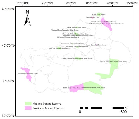
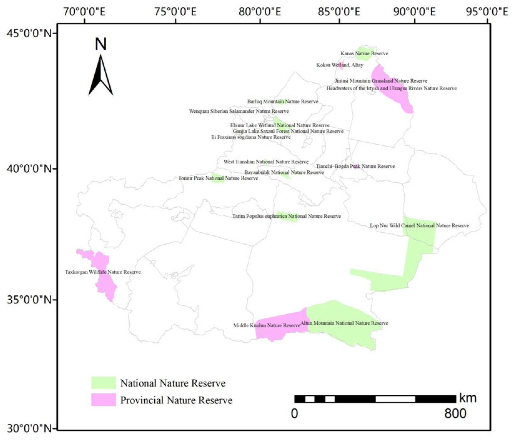
This study was conducted in the Xinjiang Uygur Autonomous Region in northwestern China (34°25′–48°10′ N, 73°40′–96°18′ E), which covers approximately 1.665 × 10⁶ km2. Situated in the hinterland of the Eurasian continent, Xinjiang has a temperate continental, arid to semi-arid climate with scarce precipitation and intense evaporation. Its topography features a ‘three mountains and two basins’ pattern: the Altai, Tian Shan, and Kunlun mountains from north to south, with the Junggar and Tarim basins in between. A total of 18 nature reserves (12 national-level and 6 provincial-level) with complete boundary vector data were obtained from the Xinjiang Forestry and Grassland Administration and used as the spatial basis for evaluating protected-area (PA) network effectiveness (Figure 1). These reserves together account for 90.5% of the total nature-reserve area in Xinjiang and were selected based on: (1) data availability—complete boundary data were obtainable, whereas the remaining 10 reserves were excluded due to incomplete or unavailable spatial data; (2) coverage of the primary distribution range of early-spring ephemerals, including the northern piedmont of the Tian Shan Mountains, the Ili Valley, the Tacheng Basin, and the foothills of the Altai Mountains; and (3) representativeness of major ecosystem types (forest, desert, grassland and wetland) and climatic gradients across Xinjiang. Hereafter, unless otherwise specified, the ‘current (existing) PA network’ refers to these 18 analyzed nature reserves, and suitable habitats falling outside their boundaries are described as ‘outside the analyzed reserves’ rather than ‘unprotected’.
Figure 1.
Distribution of nature reserves in Xinjiang.
2.2. Presence Data Collection
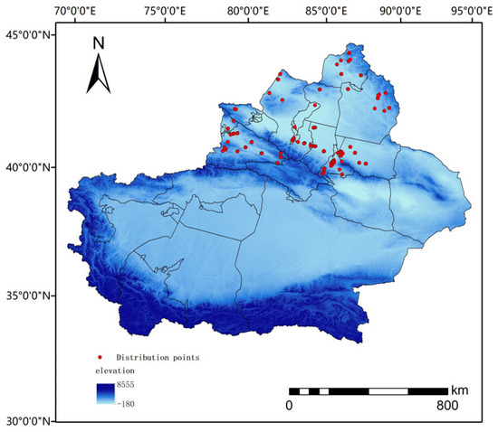
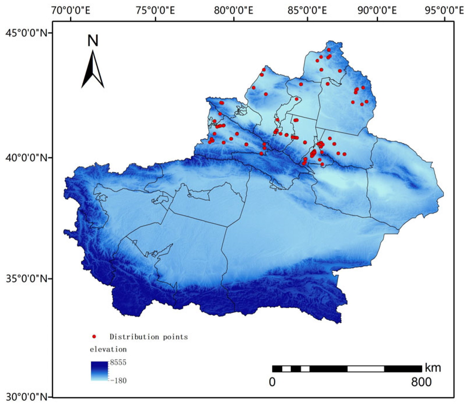
We gathered the presence data of Brassicaceae ephemeral plants during early spring in Xinjiang using two methods. First, we conducted field investigations from 2021 to 2023 with the assistance of the Department of Forestry Protection, and documented 53 occurrence points with location name, longitude, latitude, and altitude. The distances between the investigated points were >20 km. Second, we downloaded 1145 occurrence records from online databases, including 1140 records from the Global Biodiversity Information Facility (GBIF, http://www.gbif.org) and 5 records from Chinese databases such as Chinese Virtual Herbarium (CVH, http://www.cvh.ac.cn/), China National Forest Resource Continuous Inventory Platform (http://www.stgz.org.cn/), China’s Nature Reserve Specimen Resource Sharing Platform (http://www.papc.cn/), and China’s Teaching Specimen Resource Sharing Platform (http://mnh.scu.edu.cn/). In total, 1198 occurrence records were compiled from these two sources. After removing duplicate records and records with incomplete or erroneous coordinates, 349 records remained. Furthermore, to eliminate sample bias from overfitting and unclear spatial information, we used the ‘Spatially Rarefy Occurrence Data’ tool in the SDM toolbox of ArcGIS 10.8.1 to filter distribution points, retaining only one site per 10 × 10 km grid cell. This filtering grain was selected to balance bias reduction with the retention of sufficient occurrences, corresponding to the approximate scale of local habitat heterogeneity for ephemeral plants in the study region. Finally, 91 filtered records (Supplementary S1) were used to determine the final presence data for Brassicaceae early-spring ephemeral plants in Xinjiang (Figure 2).
Figure 2.
Distribution points of Brassicaceae early-spring ephemeral plants in Xinjiang.
2.3. Environmental Data
The environmental dataset comprised 19 bioclimatic and 3 topographic variables (Table 1). Climate data, including current conditions (1970–2000) and future projections for the 2050s (2041–2060) and the 2070s (2061–2080), were obtained from WorldClim 2.1 (https://www.worldclim.org) at a 30 arc-second resolution. Future projections were generated by the BCC-CSM1.1 model (Beijing Climate Center, China; CMIP5) under three representative concentration pathways (RCPs): RCP2.6 (stringent mitigation), RCP4.5 (intermediate stabilization), and RCP8.5 (high emission), representing radiative forcing levels of 2.6, 4.5, and 8.5 W/m2 by 2100 relative to pre-industrial values, respectively. Topographic variables (elevation, slope, and aspect) were derived from a 30 m DEM (Geospatial Data Cloud, http://www.gscloud.cn); slope and aspect were calculated from the DEM in ArcGIS 10.8.1, and all topographic layers were resampled to the 30 arc-second resolution of the bioclimatic variables using bilinear interpolation so that all model inputs shared an identical grid. A base map of the region was obtained from the National Fundamental Geographic Information System (http://www.ngcc.cn).
Table 1.
Description of all environmental variables.
To reduce multicollinearity among environmental variables and the risk of model overfitting, we employed a two-step procedure to select variables. Step 1: Initial modeling and Jackknife test. Using MaxEnt 3.4.4, we performed preliminary modeling with 22 initial environmental variables (19 bioclimatic variables and 3 topographic variables: elevation, slope, and aspect), with 10 repeated cross-validations. The Jackknife test was used to evaluate the independent contribution and permutation importance of each variable. Variables with both permutation importance and percentage contributions <1% were excluded. This 1% threshold served only as a preliminary screen to remove variables with negligible influence, and the ecological relevance of the retained variables was confirmed by the Jackknife test and response curves, so ecologically important variables were not excluded based on contribution values alone. Step 2: Pearson correlation analysis. We calculated Pearson’s correlation coefficients among the remaining variables across the entire modelling area, using 20,000 grid cells randomly sampled from each environmental layer, and calculated a Pearson correlation coefficient matrix, with |r| > 0.80 as the threshold for strong collinearity, a cutoff widely used in species distribution modelling to limit redundancy while retaining ecologically meaningful gradients [44]. For variable pairs exceeding this threshold, the variable with a higher Jackknife contribution was retained and the other was excluded, ensuring that the final selected variables were not strongly correlated. After this screening, five variables were retained for model construction: annual mean temperature (BIO1), mean temperature of driest quarter (BIO9), annual precipitation (BIO12), precipitation during driest month (BIO14), and precipitation seasonality (BIO15).
2.4. Distribution of Brassicaceae Early-Spring Ephemeral Plants in Xinjiang as Predicted by MaxEnt
MaxEnt was used to predict the potential distribution of ephemeral Brassicaceae plants in Xinjiang. The modelling area (M) was defined as the entire Xinjiang Uygur Autonomous Region, encompassing all known occurrences. Because these species are distributed across multiple habitats from desert margins to mountain steppes and are presumed dispersal-unlimited within the region, the regional extent was considered the most appropriate representation of the environmental background available to the plants. To reduce spatial sampling bias caused by occurrence records from different sources, duplicate records were removed, yielding 91 unique presence points. Background points (maximum 15,000) were randomly generated across this modelling area to characterize the available environmental space.
Model training and validation were performed using a 10-fold cross-validation with 10 replicates. In each replicate, the presence dataset was randomly partitioned into 10 subsets; nine subsets were used as training data, and the remaining subset was used as validation data. This process was iterated 10 times to ensure that each subset served as the validation data once. The regularization multiplier was set to 1.0, and the maximum number of background points was set to 15,000. Model outputs were generated in a logistic format, and the predictive performance was evaluated using the area under the receiver operating characteristic curve (AUC).
The output layers were imported into ArcGIS 10.8.1 for further analysis, and a final distribution map was generated. The habitat suitability index (HSI), derived from the continuous logistic output of the MaxEnt model (ranging from 0 to 1), was used to classify the potential distribution of Brassicaceae early-spring ephemeral plants in Xinjiang. HSI represents the relative suitability of a site for the species given the environmental conditions, rather than an absolute probability of occurrence; HSI of 0 indicates completely unsuitable conditions and HSI of 1 indicates optimal conditions. Based on the mean ‘Maximum Training Sensitivity Plus Specificity’ threshold (0.1362) across the 10 replicates of the final model (this criterion maximizes the sum of sensitivity and specificity and is widely used for presence-only MaxEnt models), the potential distribution was divided into four categories: unsuitable (0–0.1362), marginally suitable (0.1362–0.3), moderately suitable (0.3–0.6), and highly suitable (>0.6). Next, we calculated the suitable area under current and future climate scenarios by multiplying the number of presence grid cells by their spatial resolutions.
2.5. PA Analysis
To assess the conservation effectiveness of the existing PA network for the core habitats of Brassicaceae early-spring ephemeral plants in Xinjiang, we focused our analysis on highly suitable areas (HSI > 0.6). Prior to area calculation, all raster data were projected to an equal-area projection (Albers Equal-Area Conic, central meridian 85° E, standard parallels 25° N and 47° N) to ensure accurate area estimates, as cell area in the original 30 arc-second resolution varies with latitude. Nature reserve boundaries were converted to a raster mask (PA mask) aligned with the suitability rasters, ensuring identical extent, cell size (30 arc-seconds), origin, and coordinate reference system (WGS 1984), with pixels inside the PAs coded as 1 and those outside as 0.
Using the Zonal Statistics as Table tool in ArcGIS 10.8.1, we calculated the areal overlap between the PA mask and each suitability class raster under both current and future climate scenarios [45,46]. For each scenario, we quantified the following indicators (Table 2). Area estimates were derived from the projected equal-area raster in square kilometres, where each cell represented a constant area regardless of latitude.
Table 2.
Metrics used to evaluate protected area (PA) effectiveness for Brassicaceae early-spring ephemeral plant habitats.
3. Results
3.1. Screening of Important Model Performance and Environmental Variables
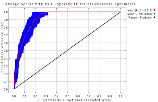
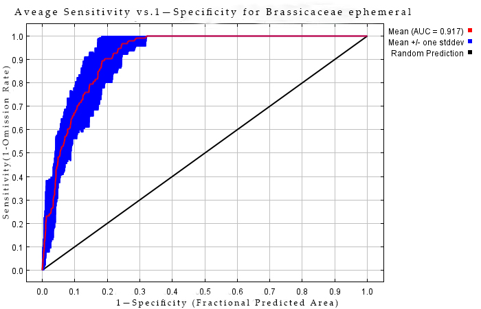
The MaxEnt model demonstrated good discriminatory performance, with an average test AUC of 0.917 (±0.023 SD, n = 10 replicates) (Figure 3).
Figure 3.
ROC curve of the MaxEnt model (average test AUC = 0.917 ± 0.023, n = 10 replicates).
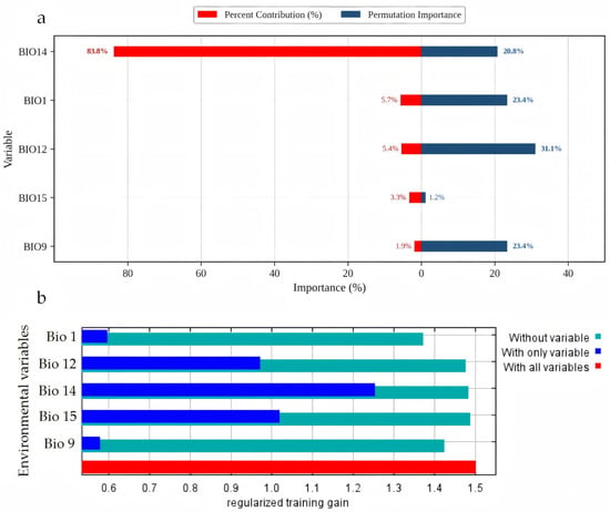
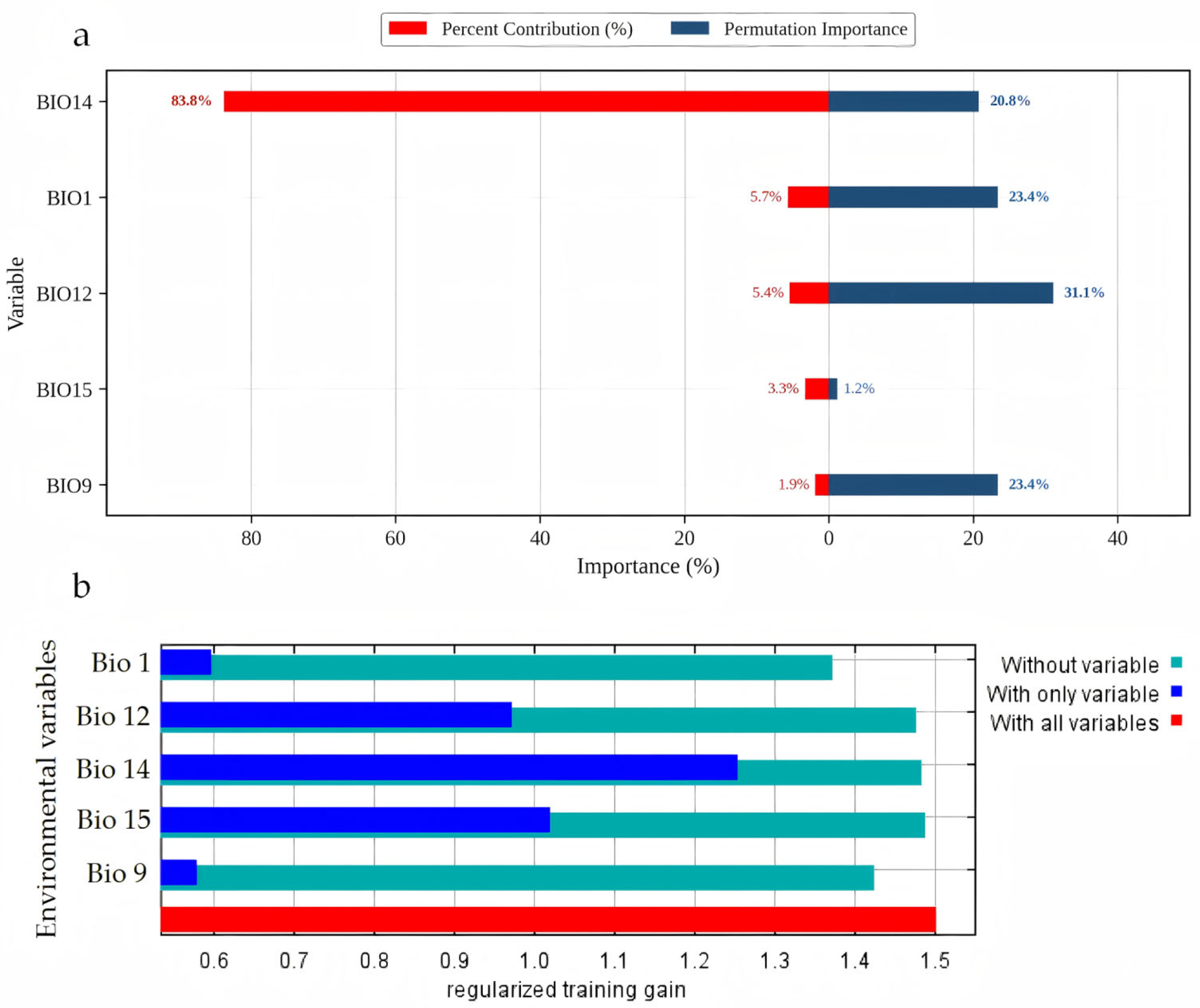
Based on the results of the environmental variable contribution rates, permutation importance, and the Jackknife test (Figure 4), among the five environmental factors included in the model, precipitation of the driest month (Bio14, 83.8%) dominated in percent contribution, followed by annual mean temperature (Bio1, 5.7%) and annual precipitation (Bio12, 5.4%), with a cumulative contribution of 94.9%. In terms of permutation importance, the top three variables were annual precipitation (Bio12, 31.1%), mean temperature of the driest quarter (Bio9, 23.4%), and annual mean temperature (Bio1, 23.4%) with a cumulative permutation importance of 77.9%. Bio14’s high percent contribution indicates that the model relies heavily on moisture availability during the driest period as a primary limiting factor. However, its relatively lower permutation importance may suggest that some of this predictive information overlaps with other correlated variables (e.g., Bio12). Conversely, the high permutation importance of Bio12, Bio9, and Bio1 indicates that these variables provide unique predictive information not captured by Bio14. Neither metric alone should be interpreted as a direct measure of ecological importance.
Figure 4.
Variable importance estimated by MaxEnt. (a) Percent contribution and permutation importance of environmental variables. (b) Jackknife test results.
The Jackknife test indicated that when only a single environmental variable was used, the variables with higher regularized training gains in descending order were precipitation of the driest month (Bio14), precipitation seasonality (Bio15), and annual precipitation (Bio12). This suggests that these variables provide more information to the model when considered individually. Conversely, when each variable was sequentially excluded from the full model, the greatest reductions in the regularized training gain were observed for annual mean temperature (Bio1) and mean temperature of the driest quarter (Bio9), indicating that temperature factors possess unique information that cannot be substituted by other environmental variables.
On integrating these results, we concluded that moisture factors are the dominant constraints on the realized geographic distribution of ephemeral Brassicaceae plants in Xinjiang. Among them, the precipitation of the driest month (Bio14) provided the greatest independent predictive information (83.8% contribution) and was the most influential predictor in the model, whereas annual precipitation (Bio12) exhibited high permutation importance (31.1%), indicating that it provides unique predictive information complementary to Bio14. Temperature variables (Bio1 and Bio9) showed a modest percent contribution (7.6%) but they carried irreplaceable unique information (as evidenced by the greatest model loss upon their exclusion), indicating that temperature exerts an essential fine-scale regulation on species distribution. Additionally, precipitation seasonality (Bio15) was also found to exert some influence on the distribution of Brassicaceae ephemeral plants.
Overall, the distribution of Brassicaceae spring-ephemeral plants in Xinjiang is governed by a mechanism wherein moisture conditions act as the primary driver and temperature conditions serve as the fine-tuning physiological modulator. Water availability, particularly precipitation replenishment during the driest month, is the foremost determinant of their survival.
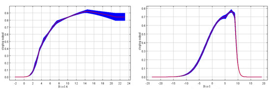
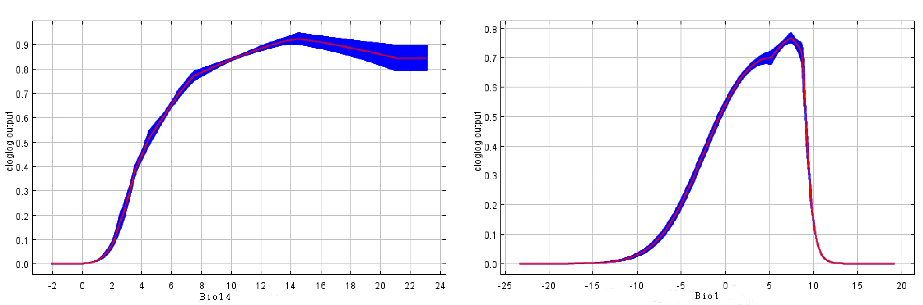
The response curves for the key bioclimatic variables are shown in Figure 5. Using a suitability value of 0.5, the suitable range for precipitation of the driest month (Bio14) was 4–20 mm, peaking at 14 mm with a suitability probability of ~0.92; after the peak, the curve declined gradually, but remained above 0.8, which indicated that these species depended on moderate precipitation replenishment during the driest month. For annual mean temperature (Bio1), the suitable range was −5 to 10 °C, peaking at 7 °C with a suitability probability of ~0.78. Both low (<−10 °C) and high (>10 °C) temperatures were associated with reduced predicted suitability, suggesting that higher predicted suitability was associated with relatively cool temperatures.
Figure 5.
Response curves of key bioclimatic variables.
3.2. Current Distribution and PA Coverage
Under the present climatic conditions, the total suitable area for Brassicaceae early-spring ephemeral plants in Xinjiang (HSI > 0.1362) was estimated to be 423.5 × 10³ km2, accounting for 25.4% of Xinjiang’s total land area. Within this zone, the highly suitable area (HSI > 0.6) covered 125.57 × 10³ km2 (29.6% of the total suitable habitat), moderately suitable areas (0.3 < HSI ≤ 0.6) occupied 173.98 × 10³ km2 (41.1% of the total suitable habitat), and low-suitability areas (0.1362 < HSI ≤ 0.3) covered 123.95 × 10³ km2 (29.3% of the total suitable habitat) (Table 3).
Table 3.
Changes in the suitable areas of Brassicaceae early-spring ephemeral plants under different periods (×103 km2).
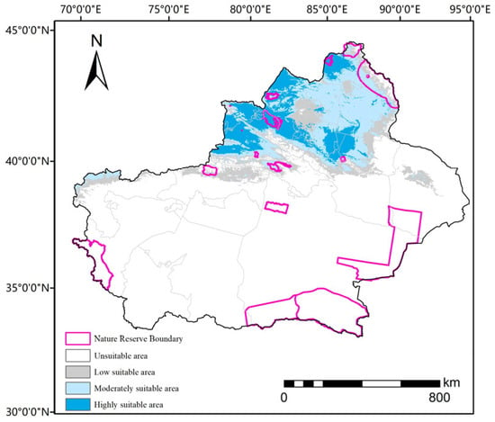
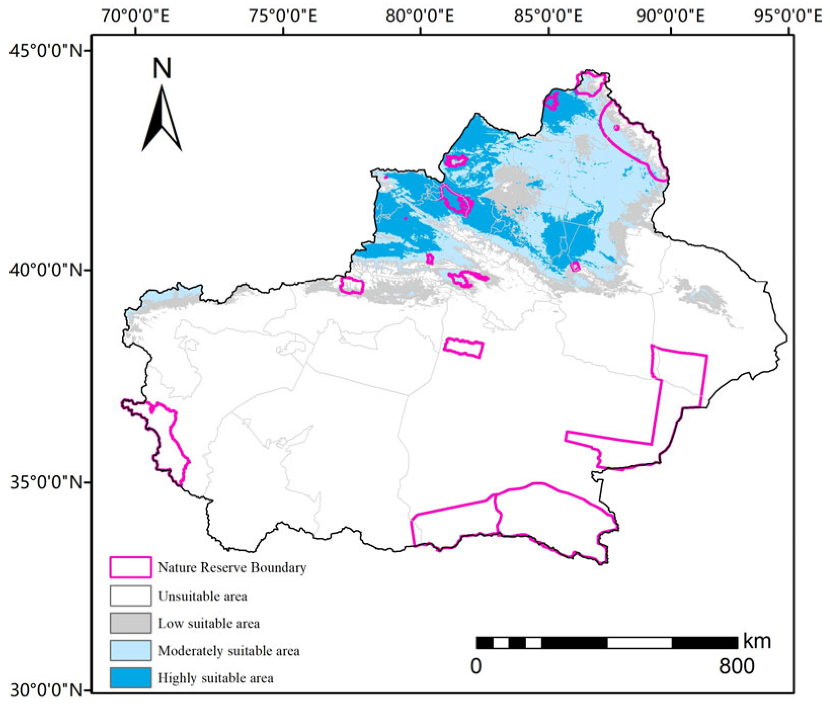
High-suitability habitats were concentrated along the northern piedmont of the Tian Shan Mountains, forming a continuous latitudinal belt extending from the Ili Valley in western Tian Shan, across the southern margin of the Junggar Basin, to the eastern Tian Shan region (Figure 6). Moderately suitable areas expanded northward into the Junggar Basin and fringed the northern Tian Shan foothills, whereas low-suitability zones were scattered along the basin margins. This spatial pattern reflects the strong ecological preference of these ephemeral species for temperate, semi-arid environments, where spring moisture—derived from snowmelt and seasonal rainfall—is abundant during their narrow phenological window.
Figure 6.
Potential distribution of Brassicaceae early-spring ephemeral plants under current climate scenario.
Despite the extensive suitable habitat, there is a pronounced spatial mismatch with the current PA network. Of the total suitable area calculated by our study, only 28.35 × 10³ km2 (6.7% of the total suitable area) falls within the current PA network, whereas 93.3% lies outside (Figure 6). This discrepancy is even more acute for the most critical habitats: merely 5.64 × 10³ km2 (4.5% of the total high-suitability area) is currently protected, and this coverage is heavily concentrated in just three reserves (Table 4): the Ebinur Lake Wetland National Nature Reserve harbors 3.32 × 10³ km2 of all protected high-suitability habitat, followed by the Koksu Wetland in the Altai region with 1.03 × 10³ km2 and the Ganjia Lake Saxaul Forest National Nature Reserve with 0.58 × 10³ km2. Together, these three reserves account for 87.4% of all protected high-suitability habitat. Conversely, many of the largest reserves in Xinjiang, including the Lop Nur Wild Camel National Nature Reserve, Altun Mountain National Nature Reserve and Middle Kunlun Nature Reserve, Taxkorgan Wildlife Nature Reserve, contain no high-suitability habitats as they are situated in desert interiors or high-elevation zones beyond the climatic niche of Brassicaceae early-spring ephemeral plants. The core high-suitability belt along the northern Tian Shan piedmont, extending from the Ili Valley through the central Junggar Basin margin to eastern Tian Shan, remains largely outside the current PA network. This severe conservation gap indicates that the existing PA network was designed for flagship species and landscape protection rather than for the specific microhabitats required by spring ephemeral communities, and that climate-driven shifts in habitat suitability may further widen this mismatch.
Table 4.
High-suitability habitat (HSI > 0.6) of Brassicaceae early-spring ephemeral plants within each analyzed nature reserve under different periods (×103 km2).
3.3. Future Distribution and PA Coverage Under Climate Change
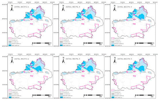
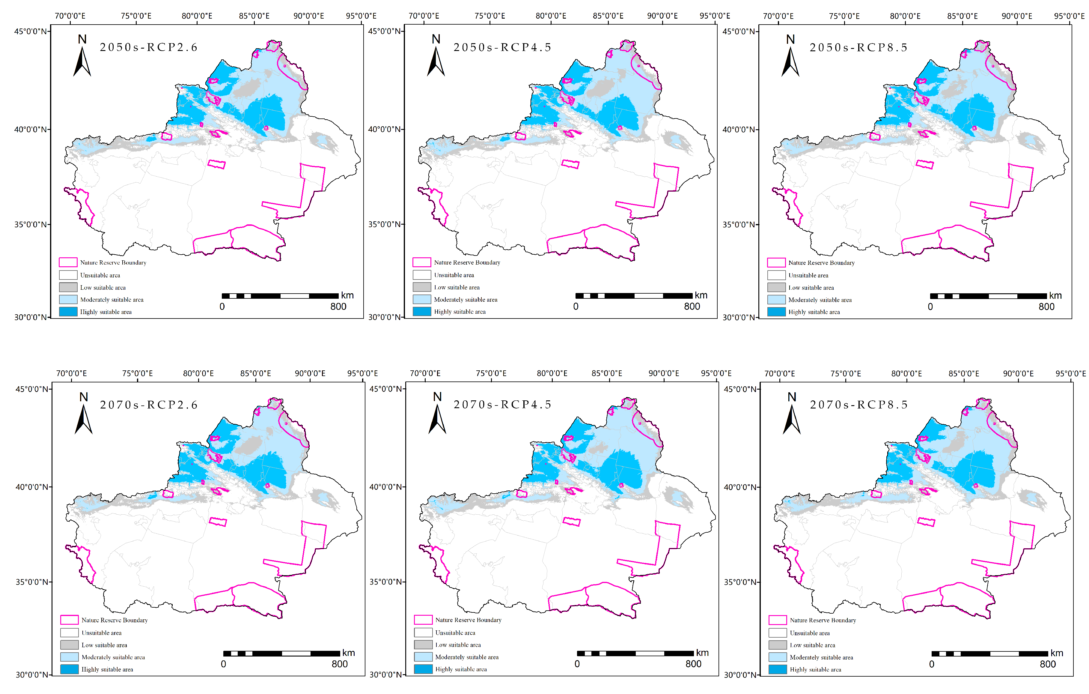
Projections under future climate scenarios revealed a paradoxical pattern for Brassicaceae spring ephemeral plants in Xinjiang. Although the total suitable area is projected to expand, the spatial match with existing PAs would deteriorate catastrophically (Figure 7; Table 3).
Figure 7.
Potential distribution maps of Brassicaceae early-spring ephemeral plants under future climate scenarios.
By the 2050s, the total suitable area (HSI > 0.1362) has been projected to increase to 478.99 × 10³ km2 (+13.1% vs. current) under RCP2.6, 481.18 × 10³ km2 (+13.6% vs. current) under RCP4.5, and 482.46 × 10³ km2 (+13.9% vs. current) under RCP8.5. This expansion will persist into the 2070s: 472.51 × 10³ km2 (+11.6% vs. current) under RCP2.6, 490.20 × 10³ km2 (+15.8% vs. current) under RCP4.5, and 479.08 × 10³ km2 (+13.1% vs. current) under RCP8.5. The highly suitable area (HSI > 0.6) is projected to follow a similar trajectory, increasing to 135.60 × 10³ km2 (RCP2.6), 132.77 × 10³ km2 (RCP4.5) and 135.32 × 10³ km2 (RCP8.5) by the 2050s, and reaching a maximum of 143.72 × 10³ km2 (RCP4.5) by the 2070s. This net expansion suggests that rising temperatures and altered precipitation regimes may open new climatically suitable zones, particularly in the northern Junggar Basin and at higher elevations.
However, this expansion masks the profound internal reorganization of habitat quality. Moderately suitable areas (0.3 < HSI ≤0.6) would fluctuate markedly across scenarios, ranging from 137.59 × 10³ km2 (2050s; RCP2.6) to 219.84 × 10³ km2 (2070s; RCP4.5), while marginally suitable areas (0.1362 < HSI ≤0.3) would vary between 126.64 × 10³ km2 (2070s; RCP4.5) and 205.80 × 10³ km2 (2050s; RCP2.6). This instability indicates that the enlarged suitable range would not be a simple northward shift in the intact habitat, but rather a northwestward shift and spatial reorganization of the core high-suitability belt along the northern Tian Shan piedmont, with newly suitable areas emerging in previously marginal regions.
Most importantly, future redistribution would decouple suitable habitats from current PA networks. Although the total suitable area within PAs would remain relatively stable at 29.71–32.69 × 10³ km2 (6.2–6.8% of the total), the high-suitability habitat within PAs would collapse significantly. Under current conditions, 5.64 × 10³ km2 of the high-suitability zone is protected; by the 2050s, this would plummet to 0.56 × 10³ km2 (0.41% of the total high-suitability area under that scenario; a 90.1% loss relative to the currently protected area) under RCP2.6, 0.45 × 10³ km2 (0.34%; a 92.0% loss) under RCP4.5, and 0.61 × 10³ km2 (0.45%; an 89.2% loss) under RCP8.5. By the 2070s, the decline would be equally severe: 0.55 × 10³ km2 (0.39%; a 90.2% loss) under RCP2.6, 0.68 × 10³ km2 (0.47%; an 87.9% loss) under RCP4.5, and 0.68 × 10³ km2 (0.52%; an 87.9% loss) under RCP8.5. Thus, 88–92% of the currently protected high-suitability habitat is projected to lose its high-suitability status across all scenarios, as newly formed high-suitability areas are projected to occur almost entirely outside current PA boundaries.
This dynamic mismatch has severe implications for conservation strategies. The three reserves currently harboring the majority of protected high-suitability habitats—the Ebinur Lake Wetland, Koksu Wetland, and Ganjia Lake—are predicted to retain only a fraction of their current value. Meanwhile, the expanded but climatically unstable suitable zone in the northern Junggar Basin and western Ili Valley would remain entirely outside the current PA network.
4. Discussion
4.1. Environmental Drivers of Brassicaceae Early-Spring Ephemeral Plants Distribution
The MaxEnt model identified precipitation during the driest month (Bio14) as the most influential predictor in the model, based on its high percent contribution (83.8%). However, it is important to note that percent contribution reflects the extent to which the model relies on a variable during training, not necessarily its exclusive ecological control. This finding aligns with the established understanding that spring-ephemeral plants in arid and semi-arid ecosystems are fundamentally constrained by moisture availability during their narrow phenological windows [8,10,11,14]. Unlike perennial desert vegetation, which can access deep groundwater or tolerate prolonged drought, ephemeral species must complete their entire life cycle, from germination to seed set, within a brief period when soil moisture is sufficient [9,17,21]. In Xinjiang, this window coincides with spring snowmelt and early seasonal rainfall. Consequently, precipitation during the driest month represents a critical bottleneck that determines the ability of seeds to successfully germinate and establish.
In contrast to their modest percent contribution, temperature variables (Bio1, Bio9) showed substantial permutation importance (23.4% each), indicating that they provide unique predictive information not captured by moisture proxies. The response curves indicate an optimal mean annual temperature of approximately 7 °C, with sharp declines in suitability below −5 °C and above 10 °C. This pattern suggests that higher predicted suitability is associated with relatively cool temperatures, reflecting the physiological constraint that these ephemerals must complete their reproduction before the onset of summer drought and extreme heat. Notably, although temperature variables showed a modest percent contribution of 7.6%, their exclusion caused the greatest reduction in the model training gain, indicating that temperature exerts a fine-tuning regulatory effect on the distribution that cannot be substituted by precipitation proxies. This asymmetric water–temperature interaction, wherein water serves as the primary limiting factor and temperature as the fine-tuning physiological modulator, mirrors the hierarchical regulation framework revealed for early-spring ephemeral communities across Central Asian cold deserts. MaxEnt-based assessments of cold desert ephemerals in Kazakhstan, Uzbekistan, and Kyrgyzstan indicate that species such as Tauscheria lasiocarpa (Brassicaceae) and Trigonella arcuata are primarily constrained by annual mean temperature (Bio1) within a narrow cool-temperate window (1–13 °C), with soil moisture and snowmelt acting as the principal limiting resources [47]. In the Kyzylkum and Karakum deserts, spring ephemeral communities similarly rely on winter–spring precipitation pulses and rapidly complete their life cycles before summer drought onset [48]. Collectively, these findings suggest that the ‘water-first, temperature-fine-tuning’ strategy represents a generalizable ecological pattern for cool-temperate desert ephemerals across the broader Central Asian region.
4.2. Current Distribution Pattern and Its Ecological Interpretation
The modeled distribution revealed a distinct latitudinal belt of suitable habitat along the northern piedmont of the Tian Shan Mountains, stretching from the Ili Valley in the west to eastern Tian Shan. This spatial pattern is consistent with the orographic rain-shadow and snowmelt hydrology of the region [49,50]: The northern Tian Shan piedmont receives reliable spring moisture from (i) orographic precipitation on north-facing slopes, and (ii) seasonal thawing, which saturates alluvial fans and loess soils [12,14,21,51]. In contrast, the Tarim Basin and southern Xinjiang are dominated by hyper-arid conditions, where spring moisture is insufficient to support an ephemeral life-history strategy [19,23,24].
The Ili Valley has emerged as the western anchor of this suitable belt, benefiting from moisture influx via westerly circulation and orographic lifting [9,50]. The Junggar Basin margin represents the central segment, where snowmelt from Tian Shan feeds into a semi-arid steppe–desert ecotone [10,11,22,51]. Eastern Tian Shan forms the eastern limit, where elevation gradients create localized moisture corridors. This tripartite structure indicates that the distribution of Brassicaceae early-spring ephemeral plants in Xinjiang is not governed by a single homogeneous climate envelope, but by a mosaic of spring-moisture microhabitats tied to topographic complexity. This has important conservation implications: protecting the species requires safeguarding not just a single ‘best’ area, but the continuity of the entire moisture corridor.
4.3. Conservation Gap: Structural Mismatch Between Habitats and PAs
Our analysis revealed a severe conservation gap that was structural rather than incidental. Only 6.7% of the total suitable area and 4.5% of the high-suitability zone fell within the current PA network. This degree of mismatch is consistent with broader assessments showing that 89.55% of seed plant diversity hotspots in Xinjiang lie outside the current PA network [52], and that over 80% of China’s native useful vascular plant hotspots are spatially mismatched with national nature reserves [53]. This mismatch arises because the PA network in Xinjiang was established for flagship vertebrate species (e.g., Camelus ferus, Equus kiang and Panthera uncia) and landscape-scale ecosystems (alpine meadows, desert riparian forests, and high-altitude wetlands), with little consideration for microhabitats of spring ephemeral plants [28,29,30]. Consequently, the vast desert reserves (Lop Nur, Altun Mountain, and Middle Kunlun) and high-altitude reserves (Tomur Peak and Bayanbulak) that dominate the PA estate occupy climatic zones entirely outside the ephemeral niche, whereas the northern Tian Shan piedmont, the core habitat, remains largely outside the current PA network.
The strong concentration of protected high-suitability habitat in three reserves (Ebinur Lake, Koksu Wetland, and Ganjia Lake; 87.4% of the total; Table 4) highlights the spatially uneven coverage of the current PA network. These three reserves are separated from one another by hundreds of kilometers of terrain outside the current PA network, creating a widely dispersed, ‘island-like’ configuration that may hinder metapopulation connectivity. For species with short dispersal distances and strict phenological timing, such isolation can lead to genetic isolation and local extinction cascades [54], particularly if spring moisture regimes become more stochastic under climate change.
4.4. Climate Change Paradox: Expanding Range, Collapsing Protection
Future projections reveal a climate change paradox that has been increasingly documented in species distribution modeling studies but remains underappreciated in conservation planning [55,56,57,58,59]. The total suitable area expands, while the overlap with PAs collapses. By the 2070s, the total suitable area was projected to increase by 11.6–15.8%, yet the high-suitability habitat within PAs declined by 88–92% across all emission scenarios (Table 3).
This decoupling occurs because climate change induces spatial reorganization rather than a simple range shift. The core high-suitability belt along the central-eastern Tian Shan piedmont is projected to shift northwestward and contract, while new high-suitability areas are projected to emerge in the western Ili Valley and the northern Junggar Basin margin, which are regions currently outside the PA boundaries. The existing reserves, designed under historical climate baselines, would thus be ‘left behind’ by the migrating climate envelope. This phenomenon has been termed ‘climate velocity mismatch’ and poses a particularly acute threat to species with limited dispersal capacity and specialized microhabitat requirements [5,60].
The internal restructuring of suitability classes adds another layer of complexity. The marked fluctuations in moderately and marginally suitable areas suggest that the expanded range is projected to be climatically unstable and lower in average quality. Under RCP8.5, the high-suitability area is projected to reach only 131.88 × 10³ km2 by the 2070s, with the most productive habitats becoming increasingly concentrated in fewer, spatially shifted areas. This implies that, even when the total suitable area increases, the ecological function of the habitat may decline.
4.5. Climate-Adaptive Conservation Strategies
Our findings demonstrated that the existing PA network, designed for flagship vertebrates and landscape-scale ecosystems, structurally excludes spring-ephemeral functional groups. Translating these findings into action, we have identified four priority steps for climate-smart conservation planning.
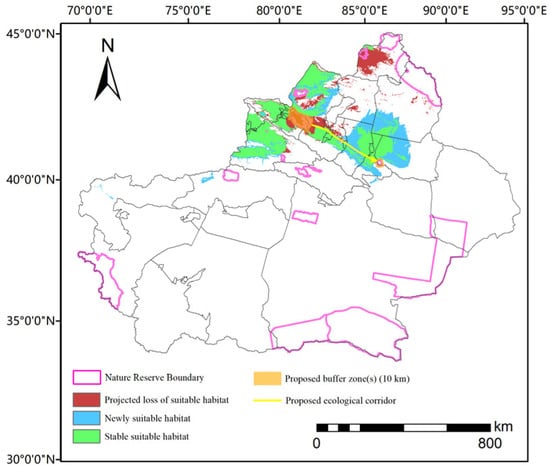
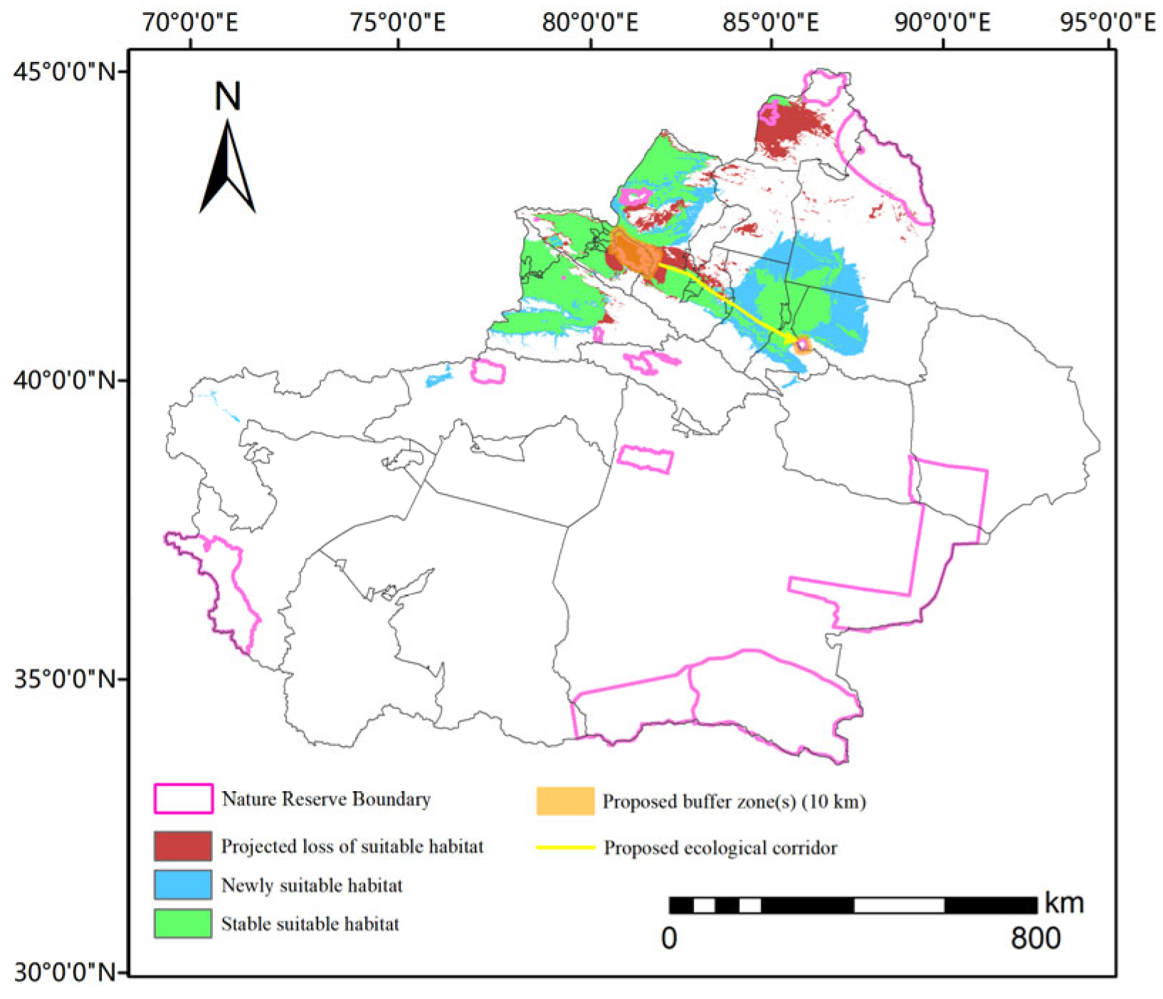
First, PA boundary expansion and connectivity. These spatially explicit recommendations were derived directly from our overlay analysis of highly suitable habitat (HSI > 0.6) under current and future scenarios and the existing PA network (Figure 8). With only 4.5% of the high-suitability habitat currently protected, of which 87.4% is concentrated in three reserves (Ebinur Lake, Koksu Wetland, and Ganjia Lake), the northern Tian Shan moisture belt remains poorly secured. Notably, the Bogda Reserve on the eastern margin of this belt contains little high-suitability habitat within its current boundaries, yet it is surrounded by extensive high-suitability habitat that is projected to expand further under future scenarios (Figure 8; Table 4). We therefore recommend establishing a conservation corridor along the northern Tian Shan piedmont, linking the Ebinur–Ganjia Lake block with the Bogda Reserve (Figure 8). We further recommend 10 km buffer zones around the two endpoint reserves, where stable or newly suitable habitat directly abuts PA boundaries, as priority sites for climate-adaptive expansion. Finally, the western Ili Valley and northern Junggar Basin margin, projected as climate refugia under future scenarios [61,62], should be prioritized for new PA designation or community-based conservation zoning. Because ephemeral communities function as integral early-spring assemblages, such corridors would concurrently benefit co-occurring companion plant species and their pollinators, aligning with the shift from species-centric to process-centric conservation.
Figure 8.
Proposed priority conservation areas for Brassicaceae early-spring ephemeral plants under climate change.
Second, dynamic buffer zone. The projected collapse of high-suitability habitats within PAs from 5.64 × 10³ km2 to 0.45–0.68 × 10³ km2 (an 88–92% loss) renders static boundaries ineffective. Existing reserves should implement flexible buffer zones extending northward toward the Junggar Basin margin and westward into the Ili Valley to capture emerging suitable areas managed as climate-adaptive transition zones rather than strict no-use cores.
Third, process-centric monitoring. Given that precipitation during the driest month (Bio14) dominated the model (83.8%), PA monitoring should integrate spring ephemeral phenology, snowmelt timing, and soil moisture dynamics during the critical March–April germination window as core indicators of management effectiveness, thereby shifting the paradigm from species-centric to process-centric conservation.
Fourth, cross-jurisdictional coordination. The high-suitability belt spans Ili, Tacheng, Changji, Ürümqi, and Hami prefectures, yet conservation planning remains fragmented across these boundaries. A regional alliance is needed to harmonize agricultural expansion controls, groundwater extraction limits, and grazing regimes during the spring phenological window when soil moisture availability determines ephemeral establishment success.
Finally, the feasibility of these measures should be considered against the regional economic context. Because 93.3% of suitable habitat and 95.5% of high-suitability habitat currently lie outside the analyzed reserves, ephemeral populations persist predominantly in working landscapes subject to grazing, cultivation, and infrastructure development across the northern Xinjiang piedmont [19,20]. We therefore emphasize low-conflict instruments—community-based conservation zoning, spring grazing regulation, and corridor siting on rangeland and marginal land rather than prime farmland—so that conservation of spring moisture corridors can be harmonized with, rather than opposed to, regional economic objectives.
4.6. Uncertainties in Future Projections and Study Limitations
Our projections are subject to several sources of uncertainty that warrant cautious interpretation. First, species distribution models provide relative assessments of habitat suitability rather than absolute forecasts of future distributions [33,39,40], and the reliability of our MaxEnt outputs depends on the spatial resolution and quality of occurrence records and bioclimatic data [33,34]. Although our 2021–2023 field surveys, combined with spatial thinning, mitigated sampling bias, the historical herbarium and database records that supplement the field data may still overrepresent accessible areas; moreover, random cross-validation may overestimate predictive performance given spatial autocorrelation. Further targeted sampling in under-recorded sectors and spatially structured validation are important directions for future work.
Second, our future projections rely on a single GCM (BCC-CSM1.1). Regional climate projections vary considerably among GCMs, and model-related uncertainty is particularly pronounced over Central Asia [63,64]. We selected BCC-CSM1.1 given its documented performance in reproducing temperature and precipitation climatology over Northwest China and Central Asia [65,66], and because the direction of projected climate signals in this region is consistent across CMIP5 ensembles. Although CMIP6 projections are now available, regional-scale comparative studies have indicated that the CMIP5 and CMIP6 ensemble means converge in directional trends for Central Asia [67]. We emphasize that this convergence pertains to the direction, not the magnitude, of projected changes and does not substitute for multi-model uncertainty quantification. We retained the CMIP5-based BCC-CSM1.1 projections for consistency with our model calibration workflow and because our conclusions rest on relative spatial shifts rather than absolute magnitudes; nevertheless, CMIP6-based multi-model ensemble analyses would provide a more complete uncertainty assessment and remain a priority for future work. We therefore expect the qualitative pattern reported here, namely the expansion of total suitable area coupled with the collapse of protected high-suitability habitat, to be robust to GCM choice, although the magnitude of area changes may vary among models.
Third, our model framework does not incorporate the potential impact of land-use change, grazing intensity, agricultural expansion, or urbanization, all of which may substantially constrain the realized distributions of early-spring ephemerals independent of climatic shifts [51].
Fourth, the physiological mechanisms underlying species responses to altered hydrothermal regimes, particularly seed-bank persistence [68], germination temperature thresholds, and reproductive phenological plasticity [43], remain poorly understood and warrant targeted investigation through controlled experiments and long-term field monitoring.
Fifth, our PA analysis covered 18 nature reserves with complete boundary data, which together account for 90.5% of the total nature-reserve area in Xinjiang (197,500 km2 of ~218,300 km2); the excluded reserves cover only ~20,800 km2 combined, dominated by the Kalamaili Reserve (14,235.58 km2, designated for Equus hemionus) and smaller reserves for flagship fauna or forest/grassland ecosystems. The three largest analyzed reserves (Altun Mountains, Lop Nur, and Middle Kunlun; 155,000 km2 combined, 78.5% of the analyzed estate) lie in hyper-arid desert interiors and high plateaus predicted to be unsuitable for early-spring ephemerals. An extreme upper-bound calculation shows that even the full overlap of all excluded reserves with suitable habitat would raise coverage only from 6.7% to 11.6% (and from 4.5% to at most 21.1% for high-suitability habitat). Other PA categories (wetland parks, forest parks, desert parks) were not analyzed owing to the lack of unified boundary data, but these are typically small and concentrated in lakeshore and forested mountain habitats distinct from the sandy piedmont plains preferred by Brassicaceae ephemerals. We therefore consider the conservation gap reported here to be robust to these exclusions.
Finally, the narrative of ‘warming and humidification’ in Northwest China requires careful contextualization. Although observational records have indicated increased precipitation at some stations in recent decades, potential evapotranspiration has risen concurrently across the region [69]. The resulting change in the aridity index has remained insufficient to cross the threshold from arid to semi-humid conditions. This climatic context reinforces our finding that moisture availability during the driest month (Bio14), rather than absolute annual precipitation gains, constitutes the persistent physiological bottleneck governing the distribution of Brassicaceae early-spring ephemeral plants. Consequently, even under future scenarios that project increased precipitation, it is unlikely that the fundamental water limitation during the critical germination window would be alleviated; this underscores the importance of creating spring-moisture corridors in climate-adaptive conservation planning for this functional group.
5. Conclusions
This study provides the first quantitative assessment of climate change vulnerability for the Brassicaceae early-spring ephemeral plants functional group in Xinjiang, along with an evaluation of the analyzed nature-reserve network. Our MaxEnt model demonstrated that moisture availability during the driest month (Bio14) was the most influential predictor, indicating that these ephemerals are fundamentally constrained by the spring soil moisture corridors along the northern Tian Shan piedmont. While the total climatically suitable range is projected to expand by 11.6–15.8% under future scenarios, the spatial decoupling of suitable habitats from the current PA network poses a far greater conservation challenge than range contraction alone. Designed for flagship vertebrates and landscape-scale ecosystems, the current PA network captures only 4.5% of core high-suitability ephemeral habitat—a share projected to fall below 1% under climate change as in-reserve high-suitability habitat declines by 88–92%. Closing this gap requires a paradigm shift from static species-centric conservation to dynamic process-oriented networks that prioritize spring moisture corridors, implement climate-adaptive buffer zones, and establish cross-jurisdictional coordination. For the conservation of ephemeral-dominant desert ecosystems, effective PA management must incorporate climate velocity into spatial planning [70] to ensure that protection migrates with the habitats it is intended to conserve.
Supplementary Materials
The following supporting information can be downloaded at https://www.mdpi.com/article/10.3390/d18090575/s1. S1: The coordinates of the Brassicaceae early-spring ephemeral plants.
Author Contributions
Conceptualization, H.N. and Y.S.; methodology, J.L. and H.N.; software, J.L., and L.L.; validation, J.L., Q.W., and X.D.; formal analysis, J.L.; resources, H.N. and Y.S.; data curation, J.L., Q.W. and X.D.; writing—original draft preparation, J.L. and H.N.; writing—review and editing, H.N.; visualization, J.L. and L.L.; supervision, H.N. and Y.S.; project administration, H.N.; funding acquisition, H.N. All authors have read and agreed to the published version of the manuscript.
Funding
This study was supported by National Natural Science Foundation of China (Grant no. 32260380) and the Natural Science Foundation of Hubei Province (Grant no. 2024AFB534).
Data Availability Statement
The raw data supporting the conclusions of this article will be made available by the authors upon request.
Acknowledgments
We thank the colleagues in the office for their assistance with this study.
Conflicts of Interest
The authors declare no conflicts of interest.
References
- IPCC. Climate Change 2014: Synthesis Report. In Contribution of Working Groups I, II and III to the Fifth Assessment Report of the Intergovernmental Panel on Climate Change; Pachauri, R.K., Meyer, L.A., Eds.; IPCC: Geneva, Switzerland, 2014. [Google Scholar]
- Van Vuuren, D.P.; Edmonds, J.; Kainuma, M.; Riahi, K.; Thomson, A.; Hibbard, K.; Hurtt, G.C.; Kram, T.; Krey, V.; Lamarque, J.-F.; et al. The representative concentration pathways: An overview. Clim. Change 2011, 109, 5–31. [Google Scholar] [CrossRef] [Scilit]
- IPCC. Climate Change 2013: The Physical Science Basis. In Contribution of Working Group I to the Fifth Assessment Report of the Intergovernmental Panel on Climate Change; Stocker, T.F., Qin, D., Plattner, G.-K., Tignor, M., Allen, S.K., Boschung, J., Nauels, A., Xia, Y., Bex, V., Midgley, P.M., Eds.; Cambridge University Press: Cambridge, UK; New York, NY, USA, 2013. [Google Scholar]
- Chen, I.C.; Hill, J.K.; Ohlemüller, R.; Roy, D.B.; Thomas, C.D. Rapid range shifts of species associated with high levels of climate warming. Science 2011, 333, 1024–1026. [Google Scholar] [CrossRef] [Scilit] [PubMed]
- Loarie, S.R.; Duffy, P.B.; Hamilton, H.; Asner, G.P.; Field, C.B.; Ackerly, D.D. The velocity of climate change. Nature 2009, 462, 1052–1055. [Google Scholar] [CrossRef] [Scilit] [PubMed]
- Thomas, C.D.; Cameron, A.; Green, R.E.; Bakkenes, M.; Beaumont, L.J.; Collingham, Y.C.; Erasmus, B.F.; De Siqueira, M.F.; Grainger, A.; Hannah, L.; et al. Extinction risk from climate change. Nature 2004, 427, 145–148. [Google Scholar] [CrossRef] [Scilit] [PubMed]
- Hannah, L. Climate Change Biology, 2nd ed.; Academic Press: Boston, MA, USA, 2015. [Google Scholar]
- Huang, G.; Li, Y.; Padilla, F.M. Ephemeral plants mediate responses of ecosystem carbon exchange to increased precipitation in a temperate desert. Agric. For. Meteorol. 2015, 201, 141–152. [Google Scholar] [CrossRef] [Scilit]
- Tang, H.P.; Yuan, S.F. Ephemeral Plants in Xinjiang, China; Higher Education Press: Beijing, China, 2021. [Google Scholar]
- Wang, X.; Jiang, J.; Lei, J.; Zhang, W.; Qian, Y. The distribution of ephemeral plants and their significance in dune stabilization in Gurbantunggut Desert. Acta Geogr. Sin. 2003, 58, 598–605. [Google Scholar]
- Peng, M.; He, H.; Wang, Z.; Li, G.; Lv, X.; Pu, X.; Zhuang, L. Responses and comprehensive evaluation of growth characteristics of ephemeral plants in the desert-oasis ecotone to soil types. J. Environ. Manag. 2022, 316, 115288. [Google Scholar] [CrossRef] [Scilit] [PubMed]
- Fan, L.; Li, Y.; Ma, J.; Mao, J.; Wang, L. Snow and rainfall independently affect the density, composition and productivity of ephemerals in a temperate desert. Sci. Total Environ. 2022, 807, 151033. [Google Scholar] [CrossRef] [Scilit] [PubMed]
- Amar, G.; Mamtimin, A.; Wang, Y.H.; Wang, Y.; Gao, J.; Yang, F.; Song, M.; Aihaiti, A.; Wen, C.; Liu, J. Factors controlling and variations of CO2 fluxes during the growing season in Gurbantunggut desert. Ecol. Indic. 2023, 154, 110708. [Google Scholar] [CrossRef] [Scilit]
- Mu, X.; Zheng, X.; Huang, G.; Tang, L.; Li, Y. Responses of ephemeral plants to precipitation changes and their effects on community in Central Asia cold desert. Plants 2023, 12, 2841. [Google Scholar] [CrossRef] [Scilit] [PubMed]
- Wang, C.; Zhu, S.; Jiang, X.; Chen, S.; Xiao, Y.; Zhao, Y.; Yan, Y.; Wen, Y. Spatio-temporal variation of species richness and phylogenetic diversity patterns for spring ephemeral plants in northern China. Glob. Ecol. Conserv. 2023, 48, e02752. [Google Scholar] [CrossRef] [Scilit]
- Urban, M.C. Accelerating extinction risk from climate change. Science 2015, 348, 571–573. [Google Scholar] [CrossRef] [Scilit] [PubMed]
- Mao, Z.; Zhang, D. The conspectus of ephemeral flora in northern Xinjiang. Arid Zone Res. 1994, 11, 1–26. [Google Scholar]
- Liu, Y.; Zhao, Y.; Wu, W.; Ao, X.; Chen, R. The response of vegetation dynamics to climate in Xinjiang from 1991 to 2018. Forests 2024, 15, 2065. [Google Scholar] [CrossRef] [Scilit]
- Yu, X.; Lei, J.Q.; Gao, X. An overview of desertification in Xinjiang, Northwest China. J. Arid Land 2022, 14, 1181–1195. [Google Scholar] [CrossRef] [Scilit]
- Qian, Y.; Zhang, L.; Wu, Z. Damage and recovery of the Gurbantunggut Desert vegetation following engineering activities. Sci. China Ser. D Earth Sci. 2002, 45, 78–86. [Google Scholar] [CrossRef] [Scilit]
- Chen, Y.; Cao, Q.; Li, D.; Liu, H.; Zhang, D. Effects of temperature and light on seed germination of ephemeral plants in the Gurbantunggut Desert, China. J. Arid Land 2019, 11, 916–927. [Google Scholar] [CrossRef] [Scilit]
- Xiao, T.; Song, F.; Vu, D.Q.; Feng, Y.; Ge, X. The evolution of ephemeral flora in Xinjiang, China: Insights from plastid phylogenomic analyses of Brassicaceae. BMC Plant Biol. 2024, 24, 111. [Google Scholar] [CrossRef] [Scilit] [PubMed]
- Li, Y.; Chen, C.; Sun, C. Drought severity and change in Xinjiang, China, over 1961–2013. Hydrol. Res. 2017, 48, 1343–1362. [Google Scholar] [CrossRef] [Scilit]
- Yao, J.; Zhao, Y.; Chen, Y.; Yu, X.; Zhang, R. Multi-scale assessments of droughts: A case study in Xinjiang, China. Sci. Total Environ. 2018, 630, 444–452. [Google Scholar] [CrossRef] [Scilit] [PubMed]
- Zhang, Y.; Xie, P.; Pu, X.; Xia, F.; An, J.; Wang, P.; Mei, Q. Spatial and temporal variability of drought and precipitation using cluster analysis in Xinjiang, Northwest China. Asia-Pac. J. Atmos. Sci. 2019, 55, 155–164. [Google Scholar] [CrossRef] [Scilit]
- An, Q.; He, H.; Gao, J.; Nie, Q.; Cui, Y.; Wei, C.; Xie, X. Analysis of temporal-spatial variation characteristics of drought: A case study from Xinjiang, China. Water 2020, 12, 741. [Google Scholar] [CrossRef] [Scilit]
- Li, Y.; Feng, Y.; Liu, B.; Lv, G.; Wang, X. Phylogenetic relationships and divergence time of Brassicaceae ephemeral plants in Xinjiang. Arid Zone Res. 2014, 31, 1100–1108. [Google Scholar]
- Yang, Y.; Yang, Z.; Han, F. Analysis of spatial distribution pattern and driving factors of nature reserves in Xinjiang. Land 2025, 14, 68. [Google Scholar] [CrossRef] [Scilit]
- Cong, W.; Li, J.; Zhang, Y.; Huang, T.; Gao, S.; Yu, J.; Zhang, Y.; Li, D. Snow leopard habitat vulnerability assessment under climate change and connectivity corridor in Xinjiang Uygur autonomous region, China. Sci. Rep. 2025, 15, 14583. [Google Scholar] [CrossRef] [Scilit] [PubMed]
- Xue, Y.; Li, J.; Zhang, Y.; Li, D.; Yuan, L.; Cheng, Y.; Liu, S.; Hacker, C.E. Assessing the vulnerability and adaptation strategies of wild camel to climate change in the Kumtag Desert of China. Glob. Ecol. Conserv. 2021, 29, e01725. [Google Scholar] [CrossRef] [Scilit]
- Lu, F.Y.; Shi, J.B.; Zhang, Z.H.; Su, X.K.; Wu, Y.; Dong, S.K.; Li, X.W.; Zhang, X.; Xu, D.H.; Gao, F.; et al. Population quantity and distribution of Tibetan antelope, Tibetan wild ass and wild yak in the Altun Mountain Nature Reserve. J. Beijing Norm. Univ. (Nat. Sci.) 2015, 51, 374–381. (In Chinese) [Google Scholar]
- Fan, L.; Liu, N.; Zhao, L.; Jiang, Z.X.; Liu, H.X. Spatial layout and regionalization of desert nature reserves. J. Soil Water Conserv. 2023, 21, 80–92. (In Chinese) [Google Scholar]
- Elith, J.; Phillips, S.J.; Hastie, T.; Dudík, M.; Chee, Y.E.; Yates, C.J. A statistical explanation of MaxEnt for ecologists. Divers. Distrib. 2011, 17, 43–57. [Google Scholar] [CrossRef] [Scilit]
- Konowalik, K.; Nosol, A. Evaluation metrics and validation of presence-only species distribution models based on distributional maps with varying coverage. Sci. Rep. 2021, 11, 1482. [Google Scholar] [CrossRef] [Scilit] [PubMed]
- Ghahremanian, A.; Ahmadi, A.; Toranjzar, H.; Varvani, J.; Abdi, N. Ecological and statistical evaluation of genetic algorithm (GARP), maximum entropy method, and logistic regression in predicting spatial distribution of Astragalus sp. Scientifica 2025, 2025, 4003408. [Google Scholar] [CrossRef] [Scilit] [PubMed]
- Elith, J.; Graham, C.H.; Anderson, R.P.; Dudík, M.; Ferrier, S.; Guisan, A.; Hijmans, R.J.; Huettmann, F.; Leathwick, J.R.; Lehmann, A.; et al. Novel methods improve prediction of species’ distributions from occurrence data. Ecography 2006, 29, 129–151. [Google Scholar] [CrossRef] [Scilit]
- Sánchez-Flores, E. GARP modeling of natural and human factors affecting the potential distribution of the invasives Schismus arabicus and Brassica tournefortii in ‘El Pinacate y Gran Desierto de Altar’ Biosphere Reserve. Ecol. Model. 2007, 204, 457–474. [Google Scholar] [CrossRef] [Scilit]
- Rong, Z.; Zhao, C.; Liu, J.; Gao, Y.; Zang, F.; Guo, Z.; Mao, Y.; Wang, L. Modeling the effect of climate change on the potential distribution of Qinghai spruce (Picea crassifolia Kom.) in Qilian Mountains. Forests 2019, 10, 62. [Google Scholar] [CrossRef] [Scilit]
- Phillips, S.J.; Anderson, R.P.; Schapire, R.E. Maximum entropy modeling of species geographic distributions. Ecol. Model. 2006, 190, 231–259. [Google Scholar] [CrossRef] [Scilit]
- Valavi, R.; Guillera-Arroita, G.; Lahoz-Monfort, J.J.; Elith, J. Predictive performance of presence-only species distribution models: A benchmark study with reproducible code. Ecol. Monogr. 2022, 92, e01486. [Google Scholar] [CrossRef] [Scilit]
- Valavi, R.; Elith, J.; Lahoz-Monfort, J.J.; Guillera-Arroita, G. Flexible species distribution modelling methods perform well on spatially separated testing data. Glob. Ecol. Biogeogr. 2023, 32, 369–383. [Google Scholar] [CrossRef] [Scilit]
- Vakulchuk, R.; Daloz, A.S.; Overland, I.; Sagbakken, H.F.; Standal, K. A void in Central Asia research: Climate change. Cent. Asian Aff. 2023, 42, 1–20. [Google Scholar] [CrossRef] [Scilit]
- Zeng, L.; Meng, W.; Zhong, X.; Peng, J.; Yang, X.-L.; Sun, L. Transcriptome analyses reveal the flowering regulatory networks in the desert ephemeral plant Eremopyrum triticeum. Front. Plant Sci. 2025, 16, 1576519. [Google Scholar] [CrossRef] [Scilit] [PubMed]
- Dormann, C.F.; Elith, J.; Bacher, S.; Buchmann, C.; Carl, G.; Carré, G.; Marquéz, J.R.G.; Gruber, B.; Lafourcade, B.; Leitão, P.J.; et al. Collinearity: A review of methods to deal with it and a simulation study evaluating their performance. Ecography 2013, 36, 27–46. [Google Scholar] [CrossRef] [Scilit]
- Özdel, M.M.; Ustaoğlu, B.; Cürebal, İ. Climate-driven futures of olive (Olea europaea L.): Machine learning-based ensemble species distribution modelling of northward shifts under aridity stress. Plants 2025, 14, 3774. [Google Scholar] [CrossRef] [Scilit] [PubMed]
- Fida, T.; Mohammadi, A.; Almasieh, K.; Bosso, L.; Din, S.U.; Shamas, U.; Nawaz, M.A.; Kabir, M. Species distribution modelling and landscape connectivity as tools to inform management and conservation for the critically endangered Himalayan brown bear (Ursus arctos isabellinus) in the Deosai National Park, Pakistan. Front. Ecol. Evol. 2025, 12, 1477480. [Google Scholar] [CrossRef] [Scilit]
- Lan, Z.; Huiliang, L.; Hongxiang, Z.; Yanfeng, C.; Lingwei, Z.; Kudusi, K.; Taxmamat, D.; Yuanming, Z. Potential distribution of three types of ephemeral plants under climate changes. Front. Plant Sci. 2022, 13, 1035684. [Google Scholar] [CrossRef] [Scilit] [PubMed]
- Gintzburger, G.; Treshkin, S.; Ryan, J. (Eds.) Grassland of the World; Chapter: Central Asia; FAO: Rome, Italy, 2004; Available online: https://www.fao.org/3/y8344e/y8344e0i.htm (accessed on 21 March 2026).
- UNESCO. Xinjiang Tianshan: World Heritage Nomination Dossier; UNESCO World Heritage Centre: Paris, France, 2013. [Google Scholar]
- Wang, W.; Yang, T.; Wang, J.; Cheng, P.; Fang, H.; Fan, G.; Liu, Q.; Ding, Y. Unraveling the spatiotemporal dynamics and drivers of drought in Xinjiang: A prefecture-scale analysis using CHIRPS and SPEI. Front. Environ. Sci. 2026, 14, 1877808. [Google Scholar] [CrossRef] [Scilit]
- Xue, Y.; Ma, J.; Ma, S.; Chen, Y.; Sun, X.; Ren, M.; Shen, L. Climate-driven redistribution of early-spring ephemeral plant communities in cold arid deserts: Evidence from the Gurbantunggut Desert, China. Plants 2026, 15, 1586. [Google Scholar] [CrossRef] [Scilit] [PubMed]
- Huang, J.; Liu, C.; Guo, Z.; Ma, K.; Zang, R.; Ding, Y.; Lu, X.; Wang, J.; Yu, R. Seed plant features, distribution patterns, diversity hotspots, and conservation gaps in Xinjiang, China. Nat. Conserv. 2018, 27, 1–15. [Google Scholar] [CrossRef] [Scilit]
- Zhao, S.; Guo, Y.; Zhao, X. Spatial mismatch between in-situ conservation and diversity hotspots of Chinese native useful vascular plants. Geogr. Sustain. 2025, 6, 100252. [Google Scholar] [CrossRef] [Scilit]
- Higgins, K. Metapopulation extinction risk: Dispersal’s duplicity. Theor. Popul. Biol. 2009, 76, 146–151. [Google Scholar] [CrossRef] [Scilit] [PubMed]
- Campos-Cerqueira, M.; Terando, A.J.; Murray, B.A.; Collazo, J.A.; Aide, T.M. Climate change is creating a mismatch between protected areas and suitable habitats for frogs and birds in Puerto Rico. Biodivers. Conserv. 2021, 30, 3509–3528. [Google Scholar] [CrossRef] [Scilit]
- Elsen, P.R.; Monahan, W.B.; Dougherty, E.R.; Merenlender, A.M. Keeping pace with climate change in global terrestrial protected areas. Sci. Adv. 2020, 6, eaay0814. [Google Scholar] [CrossRef] [Scilit] [PubMed]
- Park, I.K.; Borzée, A.; Park, J.; Min, S.; Zhang, Y.P.; Li, S.R.; Park, D. Past, present, and future predictions on the suitable habitat of the slender racer (Orientocoluber spinalis) using species distribution models. Ecol. Evol. 2022, 12, e9169. [Google Scholar] [CrossRef] [Scilit] [PubMed]
- Yousefi, M.; Nezami, B.; Asgari, F.; Illanloo, S.S.; Alemohammad, S.; Bosso, L. Climate Change Reduces Habitat Suitability of the Endemic Iranian Ground-Jay (Podoces pleskei): Spatial Analyses to Guide Conservation Strategies. Ecol. Evol. 2026, 16, e73637. [Google Scholar] [CrossRef] [Scilit] [PubMed]
- Sari, İ.; Ismael, B.; Ullah, F.; Agoundé, G.; Yildiz, F. Climatic Variables as Drivers of Pterocarpus erinaceus (Fabaceae): Distribution and the Implications of Climate Change. Ecol. Evol. 2026, 16, e72820. [Google Scholar] [CrossRef] [Scilit] [PubMed]
- Torres-Amaral, C.; Anjos, L.J.S.D.; Vieira, L.C.G.; De-Souza, E.B. The climatic risk of Amazonian protected areas is driven by climate velocity until 2050. PLoS ONE 2023, 18, e0286457. [Google Scholar] [CrossRef] [Scilit] [PubMed]
- Doxa, A.; Kamarianakis, Y.; Mazaris, A.D. Spatial heterogeneity and temporal stability characterize future climatic refugia in Mediterranean Europe. Glob. Change Biol. 2022, 28, 2413–2424. [Google Scholar] [CrossRef] [Scilit] [PubMed]
- Lopazanski, C.; Foshay, B.; Couture, J.L.; Wagner, D.; Hannah, L.; Pidgeon, E.; Bradley, D. Principles for climate resilience are prevalent in marine protected area management plans. Conserv. Lett. 2023, 16, e12972. [Google Scholar] [CrossRef] [Scilit]
- Hawkins, E.; Sutton, R. The potential to narrow uncertainty in regional climate predictions. Bull. Am. Meteorol. Soc. 2009, 90, 1095–1108. [Google Scholar] [CrossRef] [Scilit]
- Woldemeskel, F.M.; Sharma, A.; Sivakumar, B.; Mehrotra, R. Quantification of precipitation and temperature uncertainties simulated by CMIP3 and CMIP5 models. J. Geophys. Res. Atmos. 2016, 121, 3–17. [Google Scholar] [CrossRef] [Scilit]
- Duulatov, E.; Chen, X.; Amanambu, A.C.; Ochege, F.U.; Orozbaev, R.; Issanova, G.; Omurakunova, G. Projected rainfall erosivity over Central Asia based on CMIP5 climate models. Water 2019, 11, 897. [Google Scholar] [CrossRef] [Scilit]
- Wu, H.; Huang, A.; Jiang, Y.; Zhao, Y. Evaluation of the performance of BCC_CSM climate model with different horizontal resolution in simulating the summer precipitation over Central China. Arid Land Geogr. 2016, 6, 1305–1318. [Google Scholar]
- Fallah, A.; Didovets, L.; Rostami, M.; Hamidi, M. Climate change impacts on Central Asia: Trends, extremes and future projections. Int. J. Climatol. 2024, 44, 3191–3213. [Google Scholar] [CrossRef] [Scilit]
- Meyer, S.E.; Quinney, D.; Weaver, J. A stochastic population model for Lepidium papilliferum (Brassicaceae), a rare desert ephemeral with a persistent seed bank. Am. J. Bot. 2006, 93, 891–902. [Google Scholar] [CrossRef] [Scilit] [PubMed]
- Zhu, B.; Zhang, Q.; Yang, J.; Li, C. Response of Potential Evapotranspiration to Warming and Wetting in Northwest China. Atmosphere 2022, 13, 353. [Google Scholar] [CrossRef] [Scilit]
- Zhang, S.; Han, Q.; Liu, S.; Wang, Y.; Jin, L. Impact of climate change on protected area effectiveness in the middle and lower Yangtze River Basin: Implications for adaptive management. J. Environ. Manag. 2026, 401, 128928. [Google Scholar] [CrossRef] [Scilit] [PubMed]

Disclaimer/Publisher’s Note: The statements, opinions and data contained in all publications are solely those of the individual author(s) and contributor(s) and not of MDPI and/or the editor(s). MDPI and/or the editor(s) disclaim responsibility for any injury to people or property resulting from any ideas, methods, instructions or products referred to in the content. |
© 2026 by the authors. Licensee MDPI, Basel, Switzerland. This article is an open access article distributed under the terms and conditions of the Creative Commons Attribution (CC BY) license.