


Abstract
As one of the busiest airports in East China, effective bird-strike prevention is of paramount importance for Hangzhou Xiaoshan International Airport. Ground-dwelling insects in airport grasslands serve as a critical food source for insectivorous birds, making the study of insect communities essential for understanding bird activity patterns and mitigating bird-strike risks from a food chain perspective. This study investigates the communities of insects, birds, and vegetation in the flight zone and clear zone of Hangzhou Xiaoshan International Airport. Based on monthly surveys conducted from January to December 2024, we analyzed insect community composition and diversity, assessed bird-strike risks, and examined correlations between insect and bird communities. The results recorded a total of 7744 birds belonging to 107 species, 43 families, and 15 orders in the flight zone and clear zone. Passeriformes was the most species-rich order, and resident birds dominated the avian community. Bird species richness and abundance peaked in spring and autumn. In the flight zone, 18 bird species (e.g., Hirundo rustica) were classified as highly hazardous (R ≥ 15, where R is the calculated risk index) or above. The vegetation survey identified Cynodon dactylon as the dominant plant species in the flight zone. Importantly, positive trends were observed between insectivorous birds and insect abundance, though correlations did not reach statistical significance. To reduce food availability for birds, we recommend stringent management of the grassland habitat in the flight zone, including targeted insect control measures. Given the airport’s location along the East Asian-Australasian Flyway, enhanced bird dispersal efforts should be implemented during peak migration seasons. This study provides a crucial ecological foundation for developing an integrated “vegetation–insect–bird” management strategy for bird-strike prevention at Hangzhou Xiaoshan International Airport and similar aviation hubs.
1. Introduction
With the continuous improvement of China’s ecological environment and the rapid development of the civil aviation industry, the frequency of bird strikes has been increasing annually, becoming a significant threat to aviation safety [1,2]. Statistics indicate that bird strikes cause direct economic losses amounting to billions of dollars worldwide each year [3]. In 2015 alone, China’s civil aviation industry reported 1174 bird-strike incidents, with economic losses reaching approximately 119.632 million RMB [4]. Airports and their surrounding areas, characterized by open grasslands, water bodies, and abundant food resources, provide ideal habitats and foraging grounds for birds, thereby exacerbating the risk of bird strikes [5,6].
As a major aviation hub in East China, Hangzhou Xiaoshan International Airport features extensive grasslands, water bodies, and green spaces within its flight zone and surrounding areas. It is also adjacent to ecologically sensitive regions such as the Qiantang River Wetland and Xianghu Lake and is situated along the East Asian-Australasian Flyway. This unique geographical location and ecological environment make it particularly susceptible to bird-strike risks [2,7]. Previous studies have demonstrated that insects and other soil animals in airport grasslands are key factors attracting birds [8,9], and controlling insect populations can effectively reduce the incidence of bird strikes [10]. This established understanding forms the basis for investigating the fundamental ecological question underlying bird-strike prevention: What is the quantitative relationship between bird diversity and insect distribution at Hangzhou Xiaoshan International Airport, and how can this knowledge be leveraged to achieve effective bird-strike control through food web manipulation?
Currently, most airports rely on traditional bird dispersal methods such as hunting with shotguns, playing recordings of predator calls, and using propane cannons [11]. While these methods can be effective initially, their efficacy often diminishes over time as birds adapt to these environmental disturbances [12]. Therefore, there is an urgent need to develop more sustainable and scientifically sound prevention strategies. Among the various potential approaches, investigating the relationship between birds and their food resources is considered vital to addressing this issue. Although some airports have conducted research on the relationship between birds and grassland fauna [8,9], the characteristics of bird communities and their food sources vary considerably across airports due to differences in geographical location and ecological environment [13]. This study adopts a food web regulation perspective, aiming to investigate the relationship between ground-dwelling insect communities and bird communities within the flight zone and the surrounding 8 km radius of Hangzhou Xiaoshan International Airport. By analyzing their spatiotemporal distribution patterns and interrelationships and assessing high-risk bird species, this research will not only provide support for ecological management and bird-strike prevention at Hangzhou Xiaoshan International Airport but also offer insights and references for bird-strike risk control at similar aviation hubs.
2. Materials and Methods
2.1. Study Area
Hangzhou Xiaoshan International Airport (IATA: HGH, ICAO: ZSHC), constructed in 2000, is located in Xiaoshan District, Hangzhou City, at geographical coordinates 120°26′ E, 30°14′ N, approximately 27 km from downtown Hangzhou. It is a 4F-class international airport (the highest class in China, capable of accommodating large aircraft such as the A380). The region experiences a subtropical monsoon climate, characterized by distinct seasons and simultaneous rainfall and warmth. The mean annual temperature ranges from 16 to 18 °C, and the annual precipitation varies between 1300 and 1600 mm, with rainfall concentrated from May to September. Frost occasionally occurs in winter, but extremely low temperatures are rare.
The airport currently operates two runways (the longest being 3600 m), with a terminal area of 500,000 m2 (Terminals T1, T2, and T3). Within and surrounding the airport, there are artificial water bodies (e.g., drainage ponds and irrigation canals), as well as extensive grasslands, green belts, and other open spaces. Within a 13 km radius, the dominant land cover types are agricultural fields (mainly rice paddies and vegetable plots, covering approximately 35% of the area), woodlands (mixed broadleaf and coniferous forests, 20%), urban green spaces (15%), water bodies (10%), and hills/mountains (20%). The airport itself is surrounded by managed grasslands dominated by Cynodon dactylon.
2.2. Transect Setup
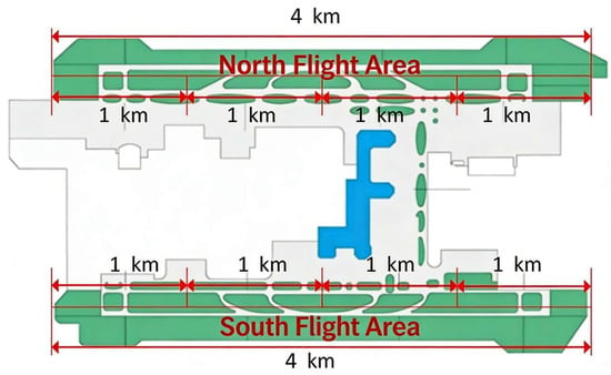
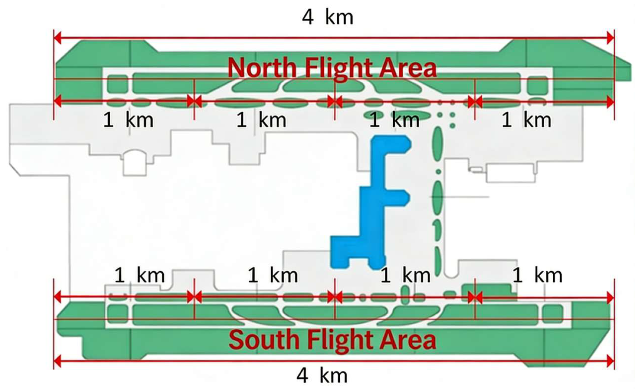
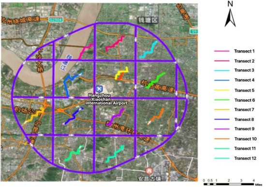
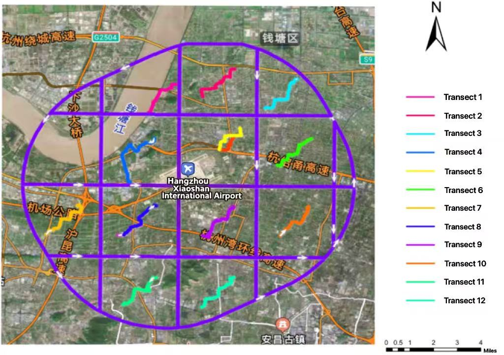
In accordance with the requirements of the Guidelines for Bird Strike Ecological Environment Surveys at Civil Airports [14] issued by the Civil Aviation Administration of China, the survey area was divided into two parts: the flight zone (runways, taxiways, and their immediate 50 m buffer) and the reference area (an 8 km radius around the airport, previously termed “clear zone”), centered on Hangzhou Xiaoshan International Airport. Based on the bird activity monitoring subzones in the northern and southern sections of the airport’s flight zone, a total of eight transects were established in the flight zone (Figure 1; four transects in the northern flight zone and four in the southern flight zone). Each transect was 1 km in length, primarily covering typical flight zone habitats such as airport grasslands and drainage ditches. The clear zone survey covered an area within an 8 km radius around the airport. Using a 5 km × 5 km grid-based partitioning method, a total of 12 transects were established (Figure 2), each approximately 3 km in length and primarily following accessible roads or footpaths, covering various habitat types including agricultural fields, woodlands, and residential areas (Table 1).
Figure 1.
Sample map of the flight area survey of Hangzhou Xiaoshan International Airport.
Figure 2.
Sample map of the clear zone investigation of Hangzhou Xiaoshan International Airport. (Non-English characters are place names and not relevant to this study.)
Table 1.
Habitat distribution of survey transects at Hangzhou Xiaoshan International Airport.
2.3. Survey Methods
2.3.1. Bird Surveys
Surveyors underwent a two-week training program prior to data collection, including bird identification using field guides and vocalizations, distance estimation, and standardized transect walking techniques. A proficiency test was passed by each observer. This study employed the fixed-distance line transect method for bird surveys. When applying this method, the following fundamental requirements must be met: first, the activities of surveyors should not affect the normal distribution of birds within the transect; second, all bird individuals within the transect range must be effectively observed and accurately identified; third, neither omission nor double-counting of individuals should occur during the survey; fourth, the actual distance between bird individuals and the transect line must be precisely measured; and finally, each bird survey transect should maintain independence from others. To maximize compliance with these requirements, we implemented the following standardized survey protocol:
Surveys were conducted monthly from January 2024 to December 2024 along the established transects in both the clear zone and flight zone of Hangzhou Xiaoshan International Airport. Additionally, nocturnal surveys were conducted in the flight zone during peak migration seasons (spring: 1 March to 31 May; autumn: 1 September to 30 November), with at least one survey per quarter. During surveys, two observers walked in parallel at a constant speed of 1.5–2.0 km/h along fixed GPS trajectories, using Swarovski 10 × 42 binoculars to observe birds within 50 m on both sides of the transect line. Recorded information included: species identification, individual counts, diet, residency type (resident: present year-round; summer visitor: breeding season only; winter visitor: non-breeding season only; passage migrant: transient during migration), and habitat at the time of observation [15]. To avoid double-counting, we adopted the criterion of “counting birds flying from the front to the back but excluding those flying from the back to the front”. All surveys were conducted within three hours after sunrise or three hours before sunset (peak bird activity periods), avoiding adverse weather conditions such as rainfall and strong winds that could affect observation. Surveyors wore uniform dark-colored clothing and moved quietly to minimize disturbance to birds. Nocturnal surveys were additionally equipped with a Pulsar thermal imaging device (Helion 2 XP50) to assist observation and ensure identification accuracy under low-light conditions. Each survey was conducted by the same survey team to ensure data consistency.
2.3.2. Insect Surveys in the Flight Zone
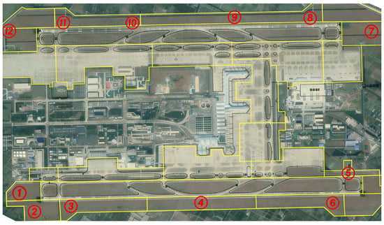
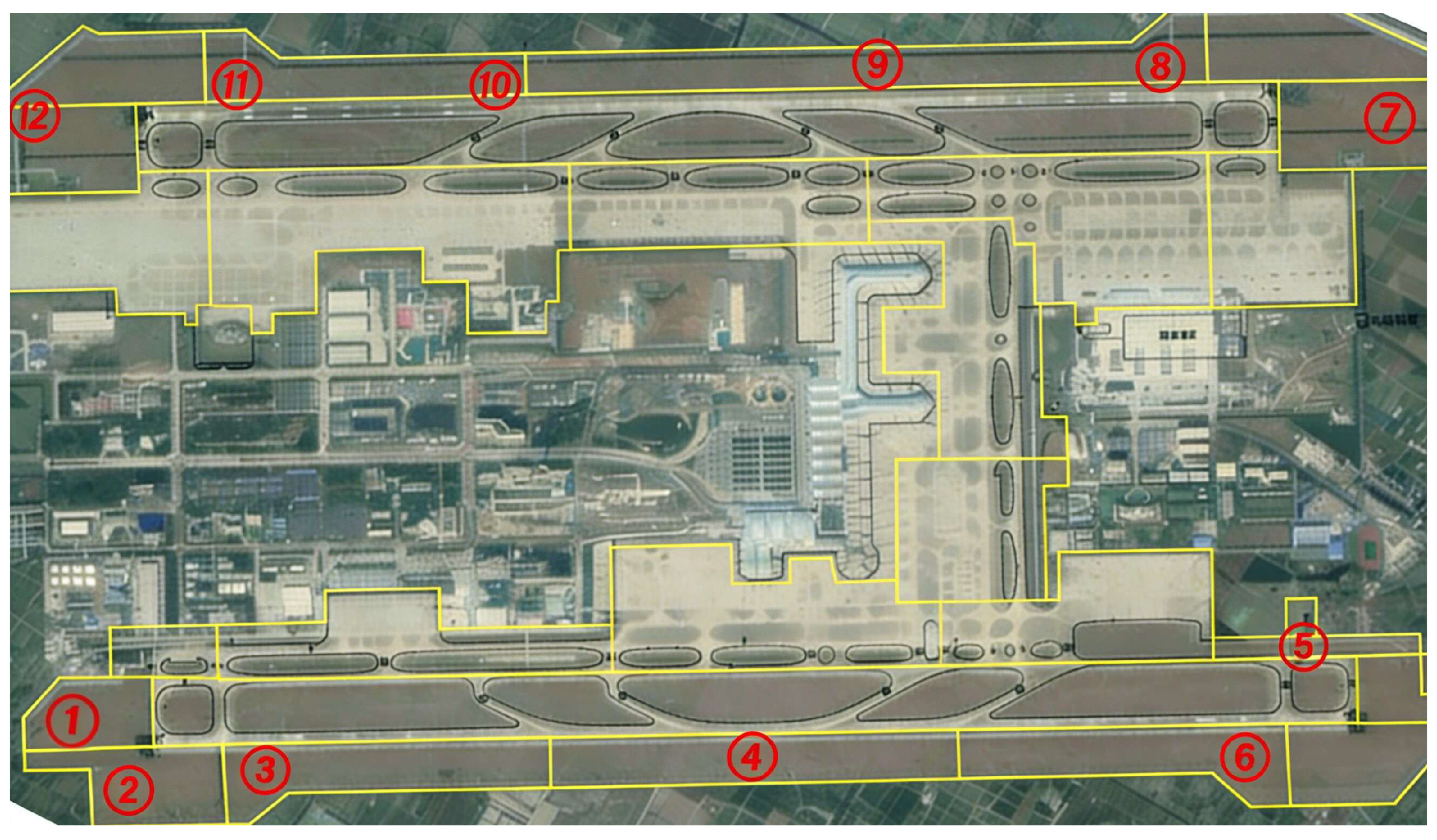
Surveys were conducted monthly from March to October 2024 (Insect activity is negligible from November to February due to low temperatures, as confirmed by preliminary observations; thus, no insect surveys were conducted during these months.) in survey areas 1–12 (as shown in Figure 3). To avoid missing soil-dwelling insects, a combined approach of sweep netting and soil excavation quadrat sampling was employed. Collected insect samples were labeled and sealed according to survey area, with samples from each sampling point placed separately in mesh bags. All samples were brought back to the laboratory for species identification and enumeration.
Figure 3.
Area division map of insect and vegetation survey at Hangzhou Xiaoshan International Airport.
Sweep Netting: Using a sweep net with a diameter of 30 cm, horizontal 180° sweeps were performed with the net maintained parallel to the vegetation, brushing the top 10–15 cm of the vegetation canopy. The net was passed through the vegetation at approximately 20 cm depth from the top. One back-and-forth sweep (left and right) was counted as one replicate unit. A total of 30 replicate sweep operations were completed in each survey area, with approximately 2 m spacing between adjacent replicates.
Soil Excavation Quadrat Sampling: One soil quadrat (1 m × 1 m) was randomly selected in each survey area. Soil was excavated to a depth of 30 cm at the center of the quadrat, and soil-dwelling animals were collected.
2.3.3. Vegetation Surveys
Vegetation surveys were conducted only in the flight zone, twice per season during the study period. Each vegetation survey was performed concurrently with the monthly insect survey and in the same survey areas to ensure temporal comparability and establish spatial correspondence between the two datasets. In each survey area, one quadrat (1 m × 1 m) was selected by a truly random process: all possible 1-m2 locations within the area were assigned coordinates, and a random number generator was used to select one quadrat per survey area. Plant species, percentage cover, and overall coverage within each quadrat were recorded to identify the dominant species. The survey followed standard vegetation quadrat methods [16].
2.4. Data Analysis
2.4.1. Calculation of Diversity Indices
The Shannon–Wiener index (H′), Pielou evenness index (J′), and Berger-Parker dominance index (d) were used to assess species diversity [17], analyze community evenness [18], and quantify the proportion of dominant species [19], respectively. The three indices were calculated using the following formulas:
where S is the total number of species; Pi is the proportion of individuals of the i-th species relative to the total number of individuals; H′ is the Shannon–Wiener index; H′max is the maximum theoretical diversity index, i.e., the diversity value when all species have equal numbers of individuals; nmax is the number of individuals of the most abundant species in the community; and N is the total number of individuals in the community.
2.4.2. Bird-Strike Risk Assessment
The risk index was calculated as R = IV × F, where IV is the importance value, defined as IV = (relative abundance + relative time + relative space)/3. Relative abundance was calculated as (number of individuals of a given species/number of individuals of the most abundant species) × 100; relative time was calculated as (number of surveys in which the species was recorded/total number of surveys) × 100; and relative space was calculated as (number of transects in which the species was recorded/total number of transects) × 100. Flight heights for each species were determined following the descriptions in A Field Guide to the Birds of China [20], supplemented by field observations during the survey period. F is the risk coefficient, assigned based on typical flight height classifications at airports as follows: 0–5 m: F = 0.1; 5–30 m: F = 0.5; 30–50 m: F = 1.0; 50–100 m: F = 0.5; >100 m: F = 0.1. Risk levels were classified as: R ≤ 5 (low risk), 5 < R ≤ 15 (moderate risk), 15 < R ≤ 25 (high risk), and R > 25 (severe risk).
2.4.3. Correlation Analysis
To quantify the relationship between bird communities and insect resources, Pearson’s correlation coefficient (r) was used:
Significance was tested using a t-test (α = 0.05). All statistical analyses were performed in R 4.2.0.
3. Results and Analysis
3.1. Composition and Spatiotemporal Distribution Characteristics of Bird Communities
3.1.1. Species Composition and Residency Types
The reference area (8 km radius, 36 km total transect length) yielded 6660 individuals of 95 species, while the flight zone (8 km transect length) yielded 1084 individuals of 64 species. Thus, the reference area had approximately six times the sampling effort, which likely contributed to the observed differences in species richness and abundance. From January to December 2024, a total of 7744 birds (1084 in the flight zone and 6660 in the clear zone) were recorded in the flight zone and clear zone of Hangzhou Xiaoshan International Airport, belonging to 107 species, 43 families, and 15 orders. Passeriformes was the most species-rich order, with 72 species (59.5%), followed by Charadriiformes with 14 species (11.6%) and Ciconiiformes with 11 species (9.1%). Residency type analysis revealed 50 resident species (46.7%), 16 summer visitors (15.0%), 27 winter visitors (25.2%), and 14 passage migrants (13.1%).
3.1.2. Seasonal Variations in Bird Communities
As shown in Table 2, bird abundance peaked in spring (March–May) and autumn (September–November), with 2745 and 2700 individuals recorded, respectively. The Shannon–Wiener diversity index (H′) was highest in spring (5.1) and lowest in winter (4.7). The Pielou evenness index (J′) was closest to 1 in summer (0.9), suggesting that the distribution of individuals among species was most uniform during the summer season.
Table 2.
Seasonal characteristics of the bird community in the flight zone and surrounding areas of Hangzhou Xiaoshan International Airport.
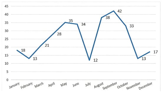
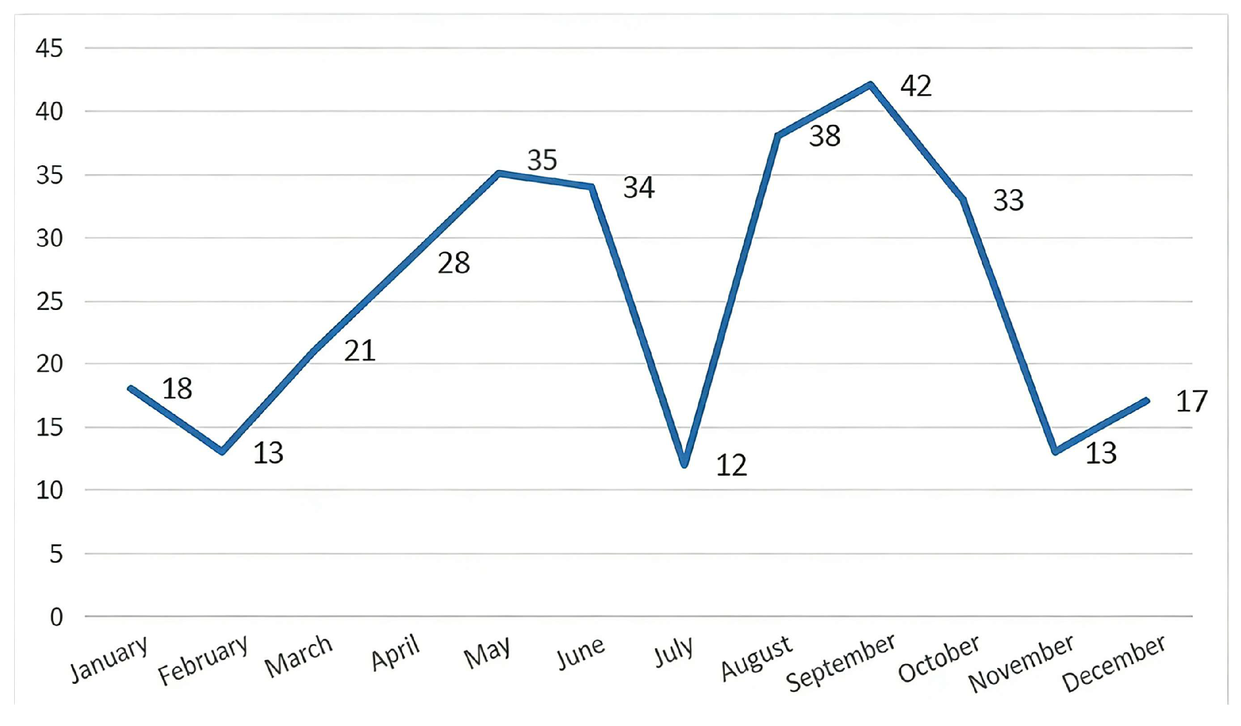
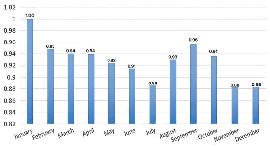
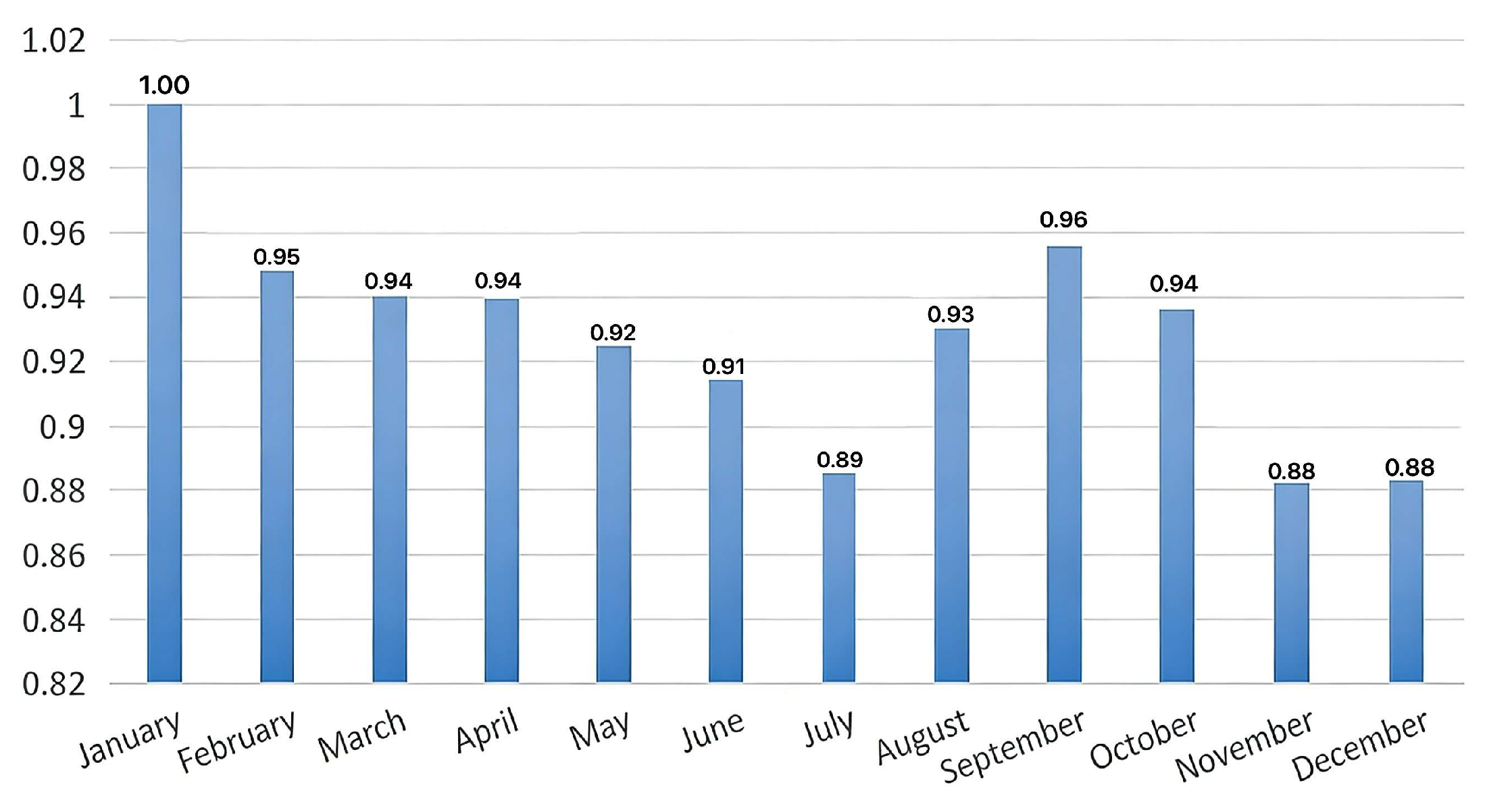
As shown in Figure 4 and Figure 5, the number of bird species active in the flight zone of Xiaoshan International Airport peaked in September (42 species), followed by May (35 species), and reached its minimum in July (12 species). The evenness index showed no significant variation except in winter, indicating a relatively stable bird community structure. The dominance index remained at a relatively high level during spring with a gradual declining trend, dropping to its first relative low of the year in summer (July).
Figure 4.
Seasonal variations in the number of bird species active in the flight zone of Xiaoshan International Airport.
Figure 5.
Seasonal variations in the dominance index of bird activity in the flight zone of Xiaoshan International Airport (All values on the y-axis are presented with two decimal places).
3.1.3. Risk Assessment of Hazardous Bird Species
Bird risk assessment followed the risk index model (R = IV × F) described in the Methods. The results (see Table 3) showed that eight bird species at Xiaoshan International Airport, including Hirundo rustica and Turdus merula, were classified as severe risk (R > 25). A total of 10 species, including Egretta garzetta and Alauda gulgula, were classified as high risk (15 < R ≤ 25). Twenty-three species, including Motacilla cinerea and Gallinago megala, were classified as moderate risk (5 < R ≤ 15). Another 23 species, including Locustella certhiola and Hypsipetes leucocephalus, were classified as low risk (R ≤ 5).
Table 3.
Highly hazardous bird species at Hangzhou Xiaoshan International Airport.
3.2. Correlation Analysis Between Insectivorous Birds and Insect Communities at the Airport
3.2.1. Compositional Characteristics of Insect Communities
During the survey period from January to December 2024, a total of 4732 grassland organisms were collected, including 471 non-insect organisms and 4261 insects belonging to 6 orders and 28 families (see Table 4). In terms of individual numbers, Hemiptera was the dominant order, accounting for 48.1% (2049 individuals), followed by Diptera, accounting for 29.5% (1258 individuals).
Table 4.
Composition of insect communities at Hangzhou Xiaoshan International Airport.
3.2.2. Seasonal Variations in Insect Communities
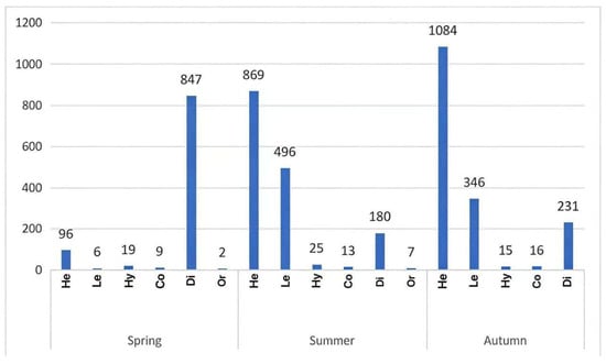
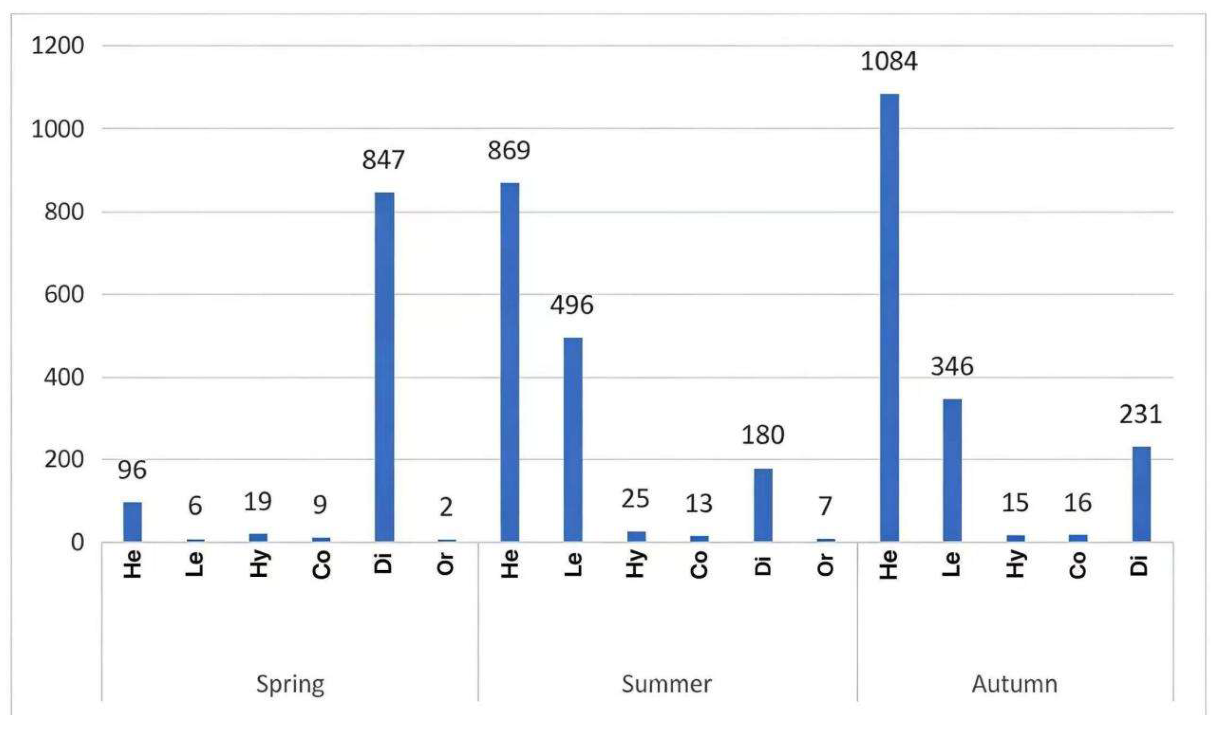
Insect abundance was highest in autumn (1692 individuals), followed by summer (1590 individuals), and lowest in spring (979 individuals; Figure 6). Diptera was the dominant order in spring, while Hemiptera dominated in summer and autumn, followed by Lepidoptera. Insect richness was higher in spring and summer compared to autumn.
Figure 6.
Seasonal variations in insects at Xiaoshan International Airport (y-axis represents the number of individuals collected per sampling period; He is Hemiptera; Le is Lepidoptera; Hy is Hymenoptera; Co is Coleoptera; Di is Diptera; Or is Orthoptera).
3.2.3. Correlation Analysis Between Insects and Insectivorous Birds
During the survey period, a total of 1084 birds belonging to 64 species were observed in the flight zone. Based on dietary classification, 50 species (1059 individuals) were classified as insectivorous birds, accounting for 98% of all individuals, while 14 species (22 individuals) were classified as non-insectivorous birds, accounting for 2%. As no insect surveys were conducted from November to February, the correlation analysis between insects and insectivorous birds was performed using only data from March to October.
There was a slight overall correlation between total insect abundance and insectivorous bird density (r ≈ 0.5), but this trend did not reach statistical significance (Table 5). A relatively more pronounced correlation was observed between Diptera abundance and insectivorous bird density (r ≈ 0.7), suggesting a positive correlation, but this trend was not statistically significant.
Table 5.
Correlation analysis between insect abundance and density of insectivorous birds.
Due to substantial differences in sampling area between bird and insect surveys (insect sampling covered only the flight zone, while bird density calculations included the entire reference area), we considered bird abundance within the flight zone as the more appropriate response variable. The results revealed a relatively positive correlation between total insect abundance and insectivorous bird abundance (r ≈ 0.7), as well as between *Diptera* abundance and insectivorous bird abundance (r ≈ 0.7; Table 6).
Table 6.
Correlation analysis between insect abundance and insectivorous bird abundance.
3.3. Vegetation Types and Seasonal Variations at Xiaoshan International Airport
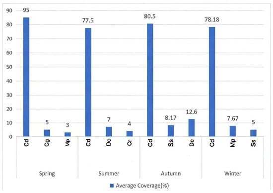
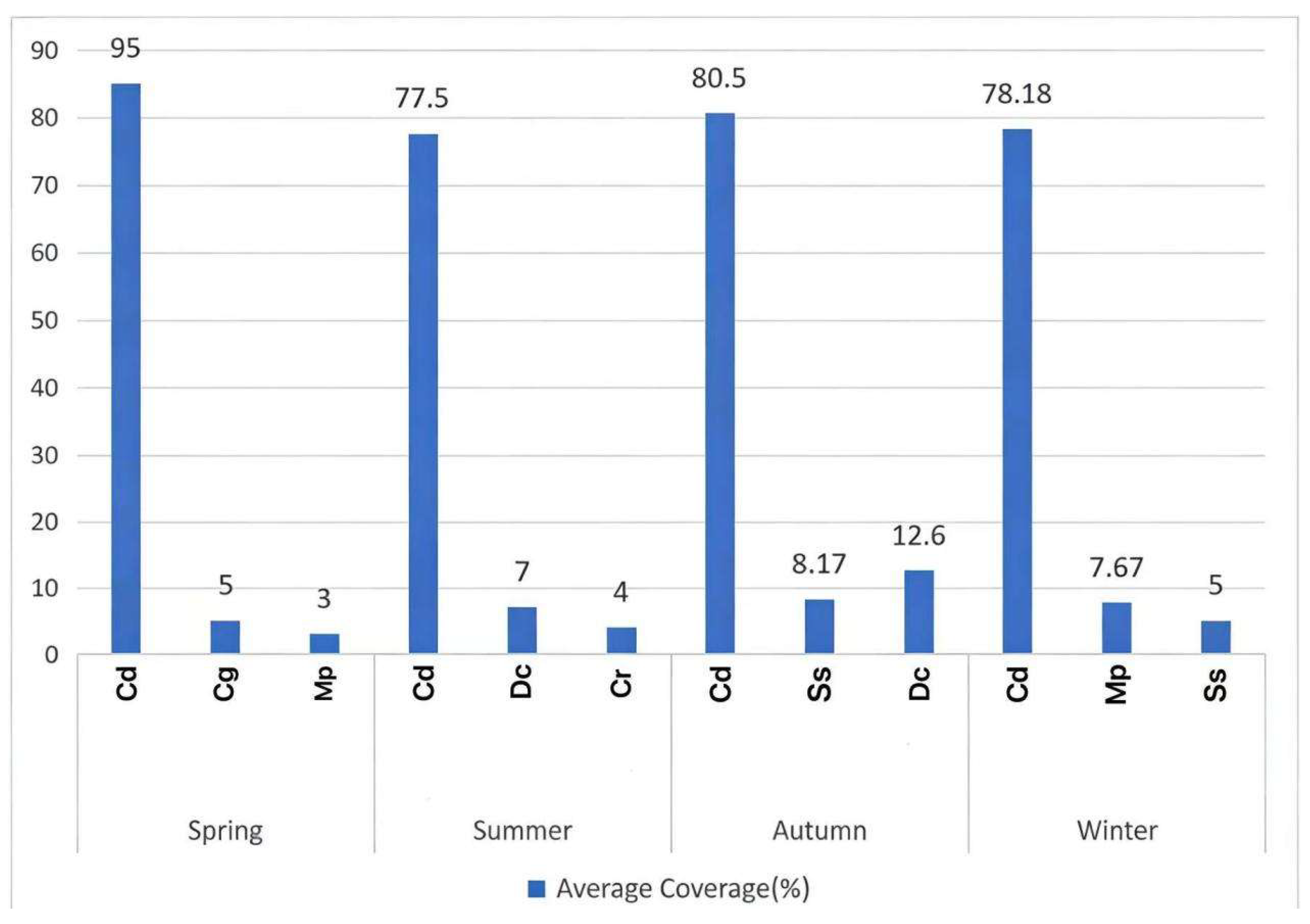
During the survey period, a total of 67 plant species belonging to 17 orders and 33 families were recorded in the quadrats established within the airport. Due to the relatively simple vegetation composition in the flight zone, only the top three dominant species in each quarter were analyzed. The results showed that Cynodon dactylon was the absolutely dominant species (Figure 7), with its mean coverage remaining at 77.5% or above throughout the year across all vegetation quadrats.
Figure 7.
Seasonal vegetation variations at Xiaoshan International Airport (Cd is Cynodon dactylon; Cg is Cerastium glomeratum; Mp is Mazus pumilus; Dc is Digitaria ciliaris; Cr is Cyperus rotundus; Ss is Symphyotrichum subulatum).
4. Discussion
4.1. Bird Community Composition and Risk Assessment
It is important to note that bird abundance and species richness were substantially lower in the flight zone than in the reference area (1084 individuals of 64 species vs. 6660 individuals of 95 species). However, the reference area had a much greater sampling effort (36 km of transects) compared to the flight zone (8 km of transects). Thus, direct comparisons of absolute diversity between the two zones should be made with caution, and the differences may partly reflect sampling intensity rather than true ecological contrasts. The diverse and abundant habitat types surrounding Hangzhou Xiaoshan International Airport are important factors contributing to the rich bird species diversity in and around the airport. Among the 107 species recorded across 15 orders and 43 families in the flight zone and clear zone, 79 species were observed within the flight zone itself. At the ordinal level, Passeriformes exhibited the highest species richness; regarding residency types, resident birds accounted for the highest proportion (50 species, 46.7%), followed by winter visitors (27 species, 25.2%), summer visitors (16 species, 15.0%), and passage migrants (14 species, 13.1%). This pattern shows similarities with bird communities at several other domestic airports, such as Chengdu Shuangliu International Airport, Chengdu Tianfu International Airport [21], as well as Yangzhou International Airport and Taizhou International Airport [22], which are geographically close to Hangzhou Xiaoshan International Airport. This phenomenon suggests that airport bird community composition is also influenced by the broader regional natural environment.
Among resident birds, 18 species were classified as high risk or above (R ≥ 15), including 8 species classified as severe risk (R ≥ 25). Resident birds generally have relatively fixed home ranges [23,24] and can survive locally throughout the year; therefore, the bird-strike risk posed by resident bird populations cannot be overlooked. Hangzhou Xiaoshan International Airport is situated along the East Asian-Australasian Flyway, with spring and autumn being the peak migration seasons [25]. During these peak migration periods, some migratory birds may pass through the airport area. Consequently, both species richness and individual abundance in the flight zone and clear zone were significantly higher in spring and autumn compared to summer and winter, a pattern further supported by the seasonal variation trends in bird dominance indices within the flight zone. This creates a phenomenon of “resident-migrant risk overlap” during peak migration seasons, substantially increasing the probability of bird strikes.
During the surveys, we observed that resident birds often exhibited specialized use of airport grasslands. For instance, nocturnal surveys frequently recorded flocks of Gallinago spp. selecting to roost on airport grasslands in the presence of actively firing propane cannons, a phenomenon that corroborates our hypothesis that birds gradually adapt to environmental disturbances. Accordingly, this study suggests that for resident birds, which inhabit fixed areas long-term and readily adapt to environmental disturbances, a combined approach could be adopted: traditional bird dispersal measures should be implemented alongside anthropogenic interventions in their habitats. This includes strict management of habitats within the airport, regular mowing and control of grass height to reduce food sources and decrease grassland concealment for birds, thereby intensifying environmental deterrence. During peak migration seasons, enhanced bird dispersal efforts could be implemented to address the “resident-migrant risk overlap” phenomenon. Although birds may habituate to acoustic devices over time, during peak migration seasons the temporary influx of naïve migratory birds may render such devices more effective. Therefore, we recommend deploying a combination of acoustic devices and laser scare cannons on a rotating schedule to delay habituation.
4.2. Scientific Control of the Avian Food Chain
Based on the vegetation types identified at Hangzhou Xiaoshan International Airport, the dominant plant species was Cynodon dactylon, which is widely selected for airport grassland establishment due to its rapid propagation and high biomass production. Previous research has demonstrated a close relationship between airport grassland vegetation types and insect communities, indicating that vegetation selection and management practices can directly influence the insect community present [26]. Among the bird species observed in the flight zone during this study, 98% were insectivorous. Correlation analyses between insects and insectivorous birds, based on both “bird density” and “bird abundance” variables, indicated slightly positive trends between insect abundance and insectivorous birds at Hangzhou Xiaoshan International Airport. Although these correlations were not statistically significant, they suggest a tendency for synchronous variation, This finding implies that insects may be among the factors attracting birds, but this interpretation requires confirmation with larger datasets. Therefore, we tentatively recommend that bird dispersal efforts be based on establishing an integrated “vegetation–insect–bird” trinity bird-strike prevention strategy along the food chain. Regular insect control operations could be conducted in airport grasslands, particularly targeting the three dominant orders—Diptera, Hemiptera, and Lepidoptera—to reduce food sources for insectivorous birds, thereby discouraging resident birds from selecting the flight zone grasslands as habitat. Furthermore, previous research [25,27] has demonstrated that the temporary stopover duration of migratory birds during migration is limited, and their decision to stop is closely related to local food abundance. Consequently, controlling insect populations within the flight zone may represent an effective approach to addressing the “resident-migrant risk overlap” phenomenon. Conversely, the high habitat diversity in the reference area (agricultural fields, woodlands, wetlands) may provide alternative foraging sites that could attract birds away from the relatively simple grassland monoculture of the flight zone. This potential “spillover” effect warrants further investigation, as it might offer a passive bird-strike mitigation strategy by maintaining attractive habitats outside the airport core area.
5. Conclusions
The results of this study indicate the following: (1) the airport’s location along the East Asian-Australasian Flyway predisposes it to the phenomenon of “resident-migrant risk overlap” during peak migration seasons and (2) the diversity of surrounding habitat types readily attracts birds for habitation. These are important factors influencing bird-strike risks at Hangzhou Xiaoshan International Airport. During the survey period (January to December 2024), a total of 7744 birds were recorded in the flight zone and clear zone, comprising 1084 individuals in the flight zone and 6660 individuals in the clear zone, belonging to 107 species, 43 families, and 15 orders. Bird species richness and abundance were higher in spring and autumn. Among the 64 bird species recorded in the flight zone, 18 species, including Hirundo rustica, were classified as high risk (R ≥ 15) or above. Birds within the airport flight zone, such as Gallinago spp., have gradually developed adaptations to traditional bird dispersal methods. The markedly dominant plant species in the flight zone grasslands was Cynodon dactylon, whose growth characteristics create favorable conditions for insects. Furthermore, weak correlations were observed between insectivorous birds and insects from the orders Diptera, Hemiptera, and Lepidoptera within the airport flight zone, indicating a trend that warrants further investigation. We tentatively recommend establishing an integrated “vegetation–insect–bird” trinity bird-strike prevention strategy alongside the use of traditional bird dispersal methods. The findings of this research provide a theoretical basis for food chain-based bird-strike prevention efforts at Hangzhou Xiaoshan International Airport, offer support for relevant work at this airport, and serve as a reference for similar aviation hubs.
Finally, we caution that this study was conducted at a single airport, and thus the findings are pseudoreplicated. Additionally, vegetation and soil insect sampling relied on only one 1 m × 1 m quadrat per survey area per month. This low spatial replication makes the estimates vulnerable to stochastic variation and limits the representativeness of the data. Standard practice recommends at least three quadrats per site; future studies should increase spatial replication to improve reliability. Inferences regarding the generality of the “vegetation–insect–bird” relationship should be made cautiously until replicated at other airports with similar ecological settings. Future research could experimentally apply different management regimes to the northern and southern flight zones (e.g., insect control alone vs. combined insect and vegetation management) to test the effectiveness of the proposed strategies, though such a design would still have limited replication.
Supplementary Materials
The following supporting information can be downloaded at: https://www.mdpi.com/article/10.3390/d18040231/s1, Table S1: Highly hazardous bird species at Hangzhou Xiaoshan International Airport.
Author Contributions
Writing—original draft, C.A., L.H.; Investigation, L.H., C.A.; Data curation, L.H., C.A.; Visualization, C.A., Y.W.; Methodology, C.A.; Writing—review and editing, H.X., Y.W.; Supervision, H.X.; Conceptualization, Y.W.; Funding acquisition, H.X. All authors have read and agreed to the published version of the manuscript.
Funding
This research was funded by The National Key R&D Program of China, grant number 2022YFD1401000. The APC was funded by The National Key R&D Program of China.
Institutional Review Board Statement
Not applicable.
Data Availability Statement
The original contributions presented in this study are included in the article/Supplementary Materials. Further inquiries can be directed to the corresponding author.
Conflicts of Interest
All authors declare that they have no conflicts of interest.
References
- Zhang, Z.; Yang, D.; Hu, M. Analysis of Avian Community Diversity in Changsha Huanghua International Airport. Chin. J. Zool. 2007, 42, 112–120. [Google Scholar]
- Zhang, J.; Zhang, J.; Gao, Y.; Wan, X. Spatial and temporal variations of bird diversity and bird-strike prevention tactics at Wuhan Tianhe Inter-national Airport. Chin. J. Ecol. 2024, 43, 3142–3151. [Google Scholar]
- Allan, J. A heuristic risk assessment technique for bird strike management at airports. Risk Anal. 2006, 26, 723–729. [Google Scholar] [CrossRef] [Scilit] [PubMed]
- CAAC Airport Department. 2015 Annual Report on Bird Strike Information Analysis for Civil Aviation in China; Civil Aviation Administration of China: Beijing, China, 2016.
- Beatty, W.S.; Webb, E.B.; Kesler, D.C.; Raedeke, A.H.; Naylor, L.W.; Humburg, D.D. Landscape effects on mallard habitat selection at multiple spatial scales during the non-breeding period. Landsc. Ecol. 2014, 29, 989–1000. [Google Scholar] [CrossRef] [Scilit]
- Soldatini, C.; Georgalas, V.; Torricelli, P.; Albores-Barajas, Y.V. An ecological approach to bird strike risk analysis. European. J. Wildl. Res. 2010, 56, 623–632. [Google Scholar] [CrossRef] [Scilit]
- Pfeiffer, M.B.; Kougher, J.D.; DeVault, T.L. Civil airports from a landscape perspective: A multi-scale approach with im-plications for reducing bird strikes. Landsc. Urban Plan. 2018, 179, 38–45. [Google Scholar] [CrossRef] [Scilit]
- Allan, J.R.; Watson, L.A. The impact of a lumbricide treatment on airfield grassland. Bird Strike Comm. Eur. 1990, 20, 531–542. [Google Scholar]
- Edmund, H. Applied ecology as a basis for bird strike prevention on airports. Vogel Und Luftverk. 1995, 15, 23–35. [Google Scholar]
- Bernhardt, G.E.; Kutschbach-Brohl, L.; Washburn, B.E.; Chipman, R.B.; Francoeur, L.C. Temporal variation in terrestrial invertebrate consumption by laughing gulls in New York. Am. Midl. Nat. 2010, 163, 442–454. [Google Scholar] [CrossRef] [Scilit]
- Gerringer, M.B.; Lima, S.L.; DeVolt, T.L. Evaluation of an Avian Radar System in a Midwestern Landscape. Wildl. Soc. Bull. 2016, 40, 150. [Google Scholar] [CrossRef] [Scilit]
- Wang, J. Environmental Stress and Biological Adaptation; China Agricultural Science and Technology Press: Beijing, China, 2021. [Google Scholar]
- Maglianesi, M.A.; Hernández, C.G.; Valenciano, A.G.; Rugama, C.R.; Jiménez, L.F.S.; Canavelli, S.B. Live Fences, Pastures and Riparian Forest: How Agricultural Lands Contribute to Bird Diversity in Northern Costa Rica. Diversity 2026, 18, 63. [Google Scholar] [CrossRef] [Scilit]
- CAAC Airport Department. Guidelines for Bird Strike Ecological Environment Investigation at Civil Airports; Civil Aviation Administration of China: Beijing, China, 2009.
- Zheng, G.M. A Checklist on the Classification and Distribution of the Birds of China, 3rd ed.; Science Press: Beijing, China, 2017. [Google Scholar]
- Fang, J.; Wang, X.; Shen, Z.; Tang, Z.; He, J.; Yu, D.; Jiang, Y.; Wang, Z.; Zheng, C.; Zhu, J.; et al. Methods and protocols for plant community inventory. Biodivers. Sci. 2009, 17, 533–548. [Google Scholar] [CrossRef] [Scilit]
- Shannon, C.E.; Weiner, W. The Mathematical Theory of Communication; University of Illinois Press: Champaign, IL, USA, 1949. [Google Scholar]
- Pielou, E.C. Ecological Diversity and Its Measurement; John Wiley & Sons: New York, NY, USA, 1975. [Google Scholar]
- Ma, K.; Qian, Y. Measurement Methods of Biodiversity; China Science and Technology Press: Beijing, China, 1994. [Google Scholar]
- MacKinnon, J. A Field Guide to the Birds of China; The Commercial Press: Beijing, China, 2022. [Google Scholar]
- Gao, X.; Fan, Q.; He, X.; Jin, L.; Zhao, X.; Fan, X.; Dou, L.; Ran, H. Influence of Landscape Patterns on Avian Diversityin the Airfield of Chengdu Tianfu International Airport. Sichuan J. Zool. 2024, 43, 121–131. [Google Scholar]
- Miao, K.; Qian, W.; Zhang, J.; Li, P.; Hu, C.; Chang, Q. Application of Functional and Phylogenetic Diversity in Airport Bird Communities: A Case Study of Yangzhou Taizhou International Airport. Chin. J. Zool. 2023, 58, 182–197. [Google Scholar]
- Marzluff, J.M.; McGowan, K.J.; Donnelly, R.; Knight, R.L. Causes and consequences of expanding American Crow populations. In Avian Ecology and Conservation in an Urbanizing World; Springer: Boston, MA, USA, 2001; pp. 331–363. [Google Scholar]
- Moreno, R.; Zamora, R.; Molina, J.R.; Vasquez, A.; Herrera, M.Á. Predictive modeling of microhabitats for endemic birds in South Chilean temperate forests using Maximum entropy (Maxent). Ecol. Inform. 2001, 6, 364–370. [Google Scholar] [CrossRef] [Scilit]
- Stepniewska, K.; Ozarowska, A.; Buse, P.; Bobrek, P. Autumn migration strategy of juvenile great reed warblers Acrocephalus arundinaceus on the eastern European flyway: A spatiotemporal pattern of accumulation and utilisation of energy stores. Eur. Zool. J. 2020, 87, 537–551. [Google Scholar] [CrossRef] [Scilit]
- Zhao, S.; Li, Z.; Duo, L. Effects of vegetation management on the composition and diversity of the insect community at Tianjin Binhai International Airport, China. Bull. Entomol. Res. 2021, 111, 553–559. [Google Scholar] [CrossRef] [Scilit] [PubMed]
- Alerstam, T. Optimal bird migration revisited. J. Ornithol. 2011, 152, 5–23. [Google Scholar] [CrossRef] [Scilit]

Disclaimer/Publisher’s Note: The statements, opinions and data contained in all publications are solely those of the individual author(s) and contributor(s) and not of MDPI and/or the editor(s). MDPI and/or the editor(s) disclaim responsibility for any injury to people or property resulting from any ideas, methods, instructions or products referred to in the content. |
© 2026 by the authors. Licensee MDPI, Basel, Switzerland. This article is an open access article distributed under the terms and conditions of the Creative Commons Attribution (CC BY) license.