


Abstract
Globally, timber production continues to dominate multiple-use forest management despite evidence from many managed landscapes that ecological integrity and biodiversity are not being sustained under that land-use model. This includes Algonquin Park where two centuries of road building, logging, and aggregate mining have contributed to a ~82% (6200 km2) reduction in unlogged, roadless (>1 km from roads) habitat at a mean decline rate of 32 km2/yr. There are at least ~5500 km of roads that fragment Algonquin Park into 732 roadless habitats covering 18% of the Park’s area. Almost 40,000 ha of these habitats are unprotected from logging. Decline of roadless habitat in Algonquin has contributed to the impairment of ecological integrity and decline of at least 34 species across all trophic levels, including at least 17 species-at-risk. Restoring the natural Algonquin Park landscape would result in job losses; however, data suggest that new recreation–tourism and research–education jobs would help to offset these losses. A new agency could build on existing infrastructure to monitor, research, educate about, maintain, and restore biodiversity and recreational resources in the greater Algonquin Park Region, with the park as the central hub. Restoration could be focused on roadless areas as an “integrative” indicator of ecological integrity.
1. Introduction
1.1. The Problem
Known for integration and contiguous placement of regulated utilitarian and protection land uses, multiple-use forest management throughout the world continues to be dominated by timber production and related ecological decline due in part to a failure to use indicators to design effective biodiversity protection strategies [1,2,3]. An understanding of ecological decline, assessed here by determining the condition (e.g., improving, stable or declining) of ecological integrity and biodiversity, is essential to achieve sustainability policy targets and desired conservation outcomes [4,5,6].
Except for Canada’s national parks [5], empirical, evidence-based assessment of biodiversity and ecological integrity is lacking throughout Canada and Ontario [3,7,8,9,10]. The loss and degradation of ecological integrity in Canada has resulted in numerous negative, cascading impacts including landscape fragmentation, declines in bird (e.g., spotted owl) and mammal species (e.g., woodland caribou), reduced carbon storage (above- and below-ground), reductions in forest age, changes in tree species composition, and loss of traditional Indigenous foods and medicines [8]. Further, the governments of Ontario and Canada have yet to implement a species at risk/wildlife conservation strategy or a broader sustainable development strategy that includes a biodiversity protection component [9].
As a case in point, ecological integrity and biodiversity in Algonquin Provincial Park, Ontario have been affected by road construction and use, aggregate mining, and forestry activities for almost two centuries [11,12] and have yet to be formally and systematically assessed for their sustainability impacts to Park ecosystems. Although recreation occurs throughout Algonquin Park and can have negative effects on forest ecosystems (e.g., [13]), numerous studies have found that recreation is not one of the primary drivers of forest degradation, which include agriculture, fire, forestry/logging, fuelwood gathering, invasive species, livestock grazing, and urbanization [14,15,16,17,18]. Algonquin is the only park in Ontario that allows logging and is one of only two provincial or national parks in Canada where logging is allowed. Duck Mountain Provincial Park in Manitoba is the other [19].
Despite provincial designation as a protected area and empirically documented ecological impacts from logging activities, resource extraction in Algonquin Park continues based on the assurance that these activities are being conducted sustainably [11,20,21] while the claim has also been made that the entire Park is protected from resource extraction [22]. More critically, however, is that the Park’s natural habitats have been diminishing at an accelerating rate as forestry mechanization and efficiency has improved over the last 200 years [23,24].
Impacts from logging and associated activities from use of a ~5500 km interior road system in Algonquin Park have penetrated all trophic levels ranging across numerous species groups and habitat types contributing to losses of biodiversity, carbon storage, and forest productivity (e.g., [25,26,27]). A key to effective management of ecological integrity and biodiversity in Algonquin Park and beyond is to understand the biogeography of the remaining patches of roadless wildlife habitat (RWH) that represent areas of highest ecological integrity and the threats to them [6,8]), which are currently unknown.
1.2. The Park
Home to many First Nations Algonquin People for 8000 years, as Canada’s first provincial park, and as the foundation of the protected areas system in Ontario, Algonquin Park (est. 1893) has long been considered Ontario’s “flagship” protected area ([28,29], Figure 1 and Figure 2).
At ~760,000 ha (7600 km2), it received ~1.1 M visitors seeking a recreational experience in 2022. However, unlike all other provincial parks in Ontario, ~65% of Algonquin Park (~4000 km2 of land) is open to logging and aggregate mining [30], despite the Ontario government claim that the Park protects more than 1.9 million acres (760,000 ha) [22]. Permission for companies to log in the Park is currently granted and guided by both the Provincial Parks and Conservation Reserves Act [31] and the Algonquin Forestry Authority [AFA] Act [32]; however, the AFA began operating in 1974.
Figure 1.
Protected and Unprotected Roadless Areas (1 km buffer) in Algonquin Park, Ontario [33,34].
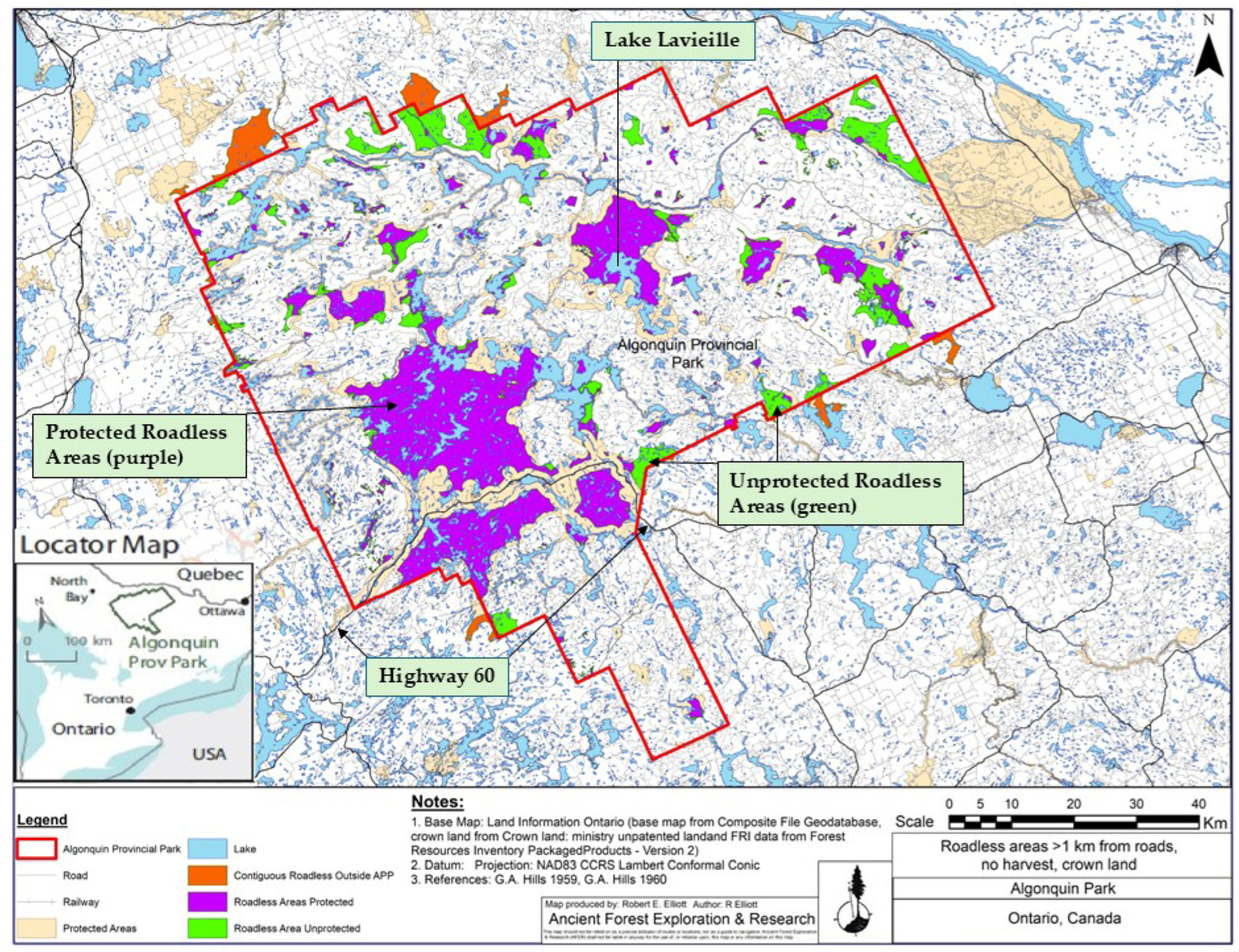
Figure 2.
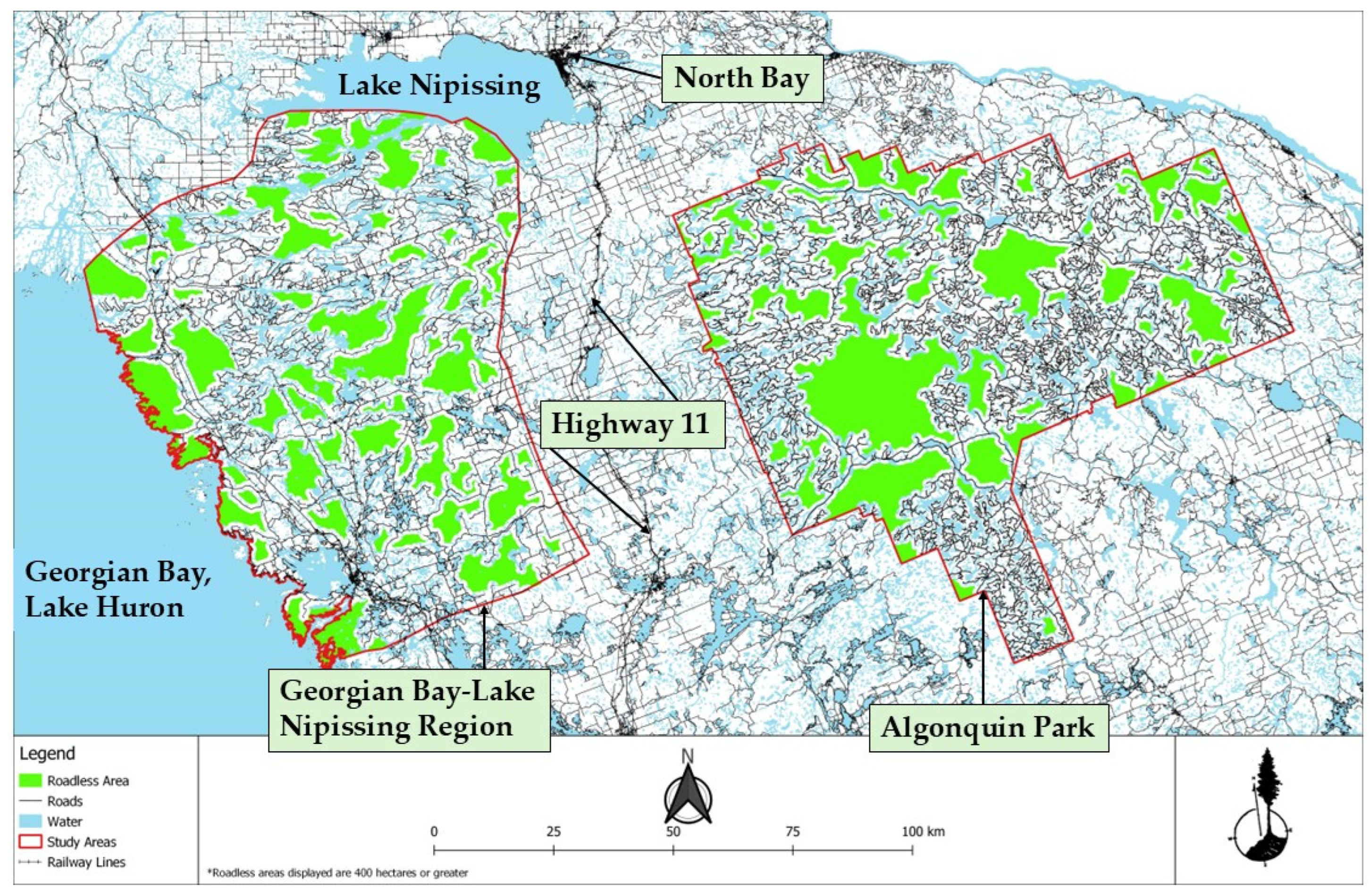
Roads and Roadless Areas (1 km buffer; *: 400+ ha) in Algonquin Park and the Georgian Bay-Lake Nipissing Region, Ontario.
As the primary authority over Park management, the Provincial Parks and Conservation Reserves Act [31] prioritizes both ecological integrity and biodiversity; however, ecological integrity is the highest priority. The purpose of the Act is to
“Permanently protect a system of provincial parks and conservation reserves that includes ecosystems that are representative of all of Ontario’s natural regions, protects provincially significant elements of Ontario’s natural and cultural heritage, maintains biodiversity and provides opportunities for compatible, ecologically sustainable recreation…” “maintenance of ecological integrity shall be the first priority and the restoration of ecological integrity shall be considered”.[31]
The Act defines ecological integrity as
“a condition in which biotic and abiotic components of ecosystems and the composition and abundance of native species and biological communities [biodiversity] are characteristic of their natural regions and rates of change and ecosystem processes are unimpeded”. It “includes, but is not limited to, (a) healthy and viable populations of native species, including species at risk, and maintenance of the habitat on which the species depend; and (b) levels of air and water quality consistent with protection of biodiversity and recreational enjoyment”.[31]
1.3. Purpose and Objectives
The legislated requirement to sustain ecological integrity and biodiversity in natural condition within Ontario parks and nature reserves was evaluated using Algonquin Park as a case study by assessing declines for indicators of ecological integrity and for species (biodiversity) using results from published and unpublished literature, and from original empirical analysis. Original data were composed of roadless areas (RAs), or RWH, which is an “integrative” indicator of ecological integrity that does not account for any individual, specific indicator but represents an amalgamation of the many factors (e.g., soil erosion, tree high-grading, dust, noise, etc.) that cause reduced wildlife habitat quality within road buffer zones. In general, RWH represents the least-disturbed portions of a landscape and by default has the highest ecological integrity [35,36].
The objectives of this study of Algonquin Park were: (1) to address: (a) the decline of biodiversity and ecological integrity using available data (published and unpublished literature) as well as original data from this study and (b) prospects for ecological restoration focusing on RWH; (2) to conduct an assessment of RWH as an integrated indicator of ecological integrity; (3) to determine RWH conservation status; (4) to map RWH; (5) to compare and contrast RWH in Algonquin Park to RWH in a similarly sized, adjacent unprotected region.
2. Methods
All available roads data and the GIS software program ArcMap (10.8.1) were used to buffer roads and logged areas by 1 km within Algonquin Park. This buffer width (1 km) was the most encountered buffer width in the literature (e.g., [37,38,39]) and it matched a buffer width used by the only other Ontario-focused study to map roadless areas [37]. Roads data were obtained from: Ontario GeoHub, the Ministry of Natural Resources and Forestry Road Network dataset, the Ontario Railway Network dataset, Algonquin Forestry Authority, the Wilderness Committee-Ontario, and through Google image visual road surveys. Previously logged areas were added to the buffered areas using Ontario Forest Resources Inventory data [40].
All areas not included within the buffered areas were considered RWH (e.g., [37,38,39]) defining the areas of highest ecological integrity remaining in Algonquin Park. All buffered corridors (included hydro lines and railways) are referred to as “roads” in the remainder of this paper. Trails and portages were not buffered. Old roads viewed on imagery that were not connected to the continuously linked road network (separate road segments) were excluded from the analysis since they may potentially be in restoration mode.
The Georgian Bay-Lake Nipissing (GBLN) Region boundaries (Figure 2) were created by shifting the northern boundary of the Georgian Bay Fringe area [41] further northward to match the northern latitude of Algonquin, by leaving the western boundary located along the Lake Huron coastline, and by moving the eastern boundary further eastward to achieve a size similar to the Park from ~622,500 ha to 763,268 ha to more closely match the 761,046 ha size of Algonquin Park.
Species declines and indicators of ecological integrity [42,43,44,45] were the focus of the literature review given their key-metric status in the Provincial Parks and Conservation Reserves Act [31]. The ecological integrity scorecard utilized by the Northeast Temperate Network [6] and five criteria relating to drivers of forest degradation and loss of ecosystem services [17] guided selection of ecological integrity indicators. The sustainability of species populations and ecological integrity were evaluated by categorizing them as either improving, stable, or declining (or negative value) as developed and applied by Parks Canada [5].
3. Results
3.1. Roadless Wildlife Habitat
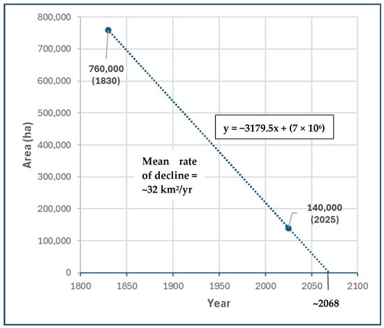
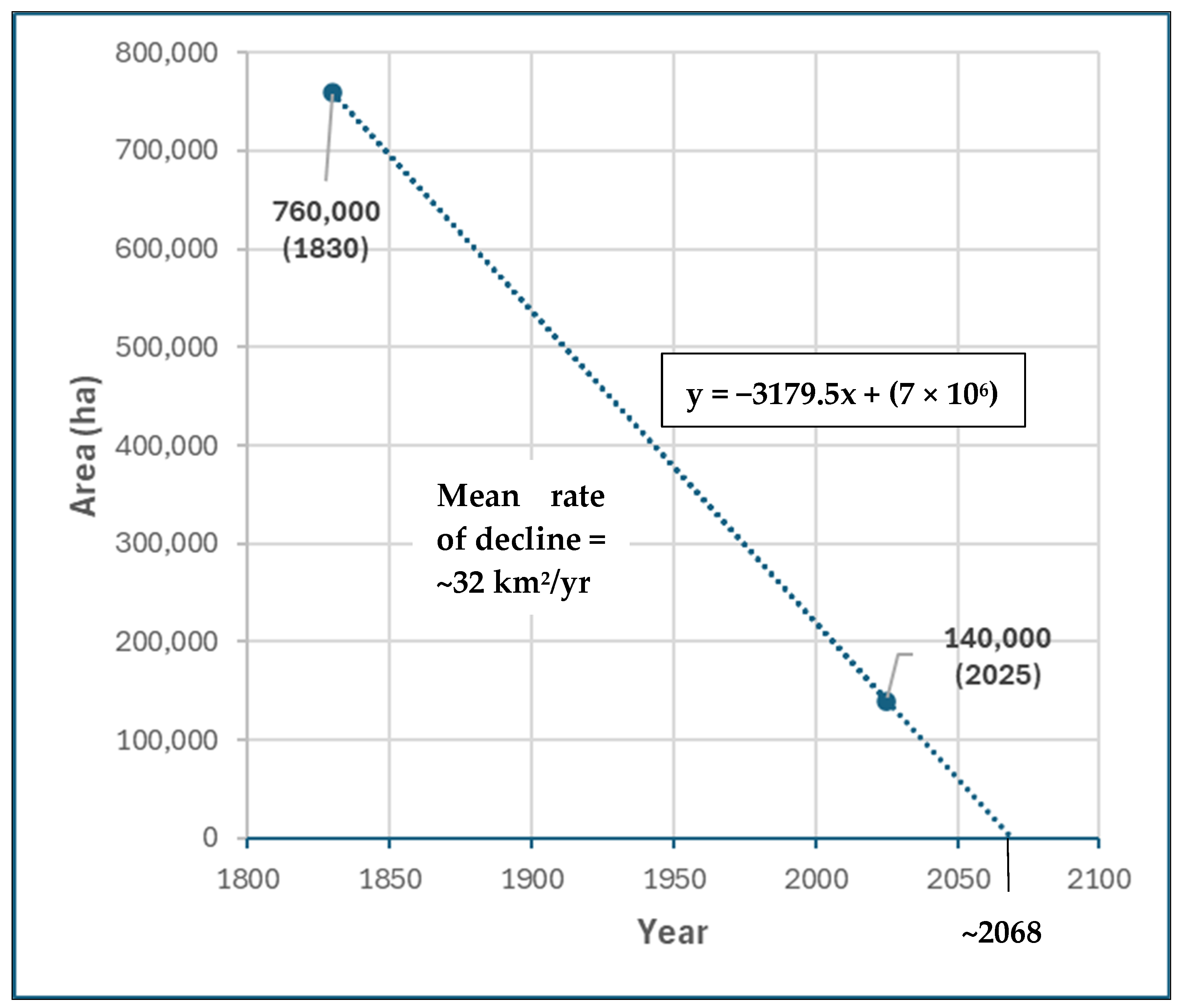
Over two centuries, RWH in Algonquin Park declined by 82% at a mean rate of ~32 km2/yr. (~6200 km2/200 yrs; Figure 3). The remaining 732 RWH patches varied in size from 0.1 ha to 51,327 ha for a total of 136,704 ha covering 18% of the Park’s area (Figure 2; Table 1) resulting from at least ~5500 km of forest access roads, which is slightly less than the 5800 km of roads in Algonquin Park reported by [46]. The highest concentration of RWH in Algonquin was in the central portion of the west side (Figure 1 and Figure 2) where very little RWH was found along the western border and in the southern pan-handle areas. On the east side of the Park, the largest patch of RWH surrounded Lake Lavieille, and two other mid-sized patches of RWH were located a few km southeast of this lake. Five mid-sized patches of RWH were scattered along the northern Park boundary and numerous other small patches of RWH were distributed primarily throughout the northern portion of the Park.
Figure 3.
Rate of Decline of Roadless Wildlife Habitat in Algonquin Park, Ontario from 1830 to 2025.
Table 1.
Comparing Roadless Area Metrics in Algonquin Park with those in the Georgian Bay-Lake Nipissing Region, Ontario.
Of all RWH patches, 568 were smaller than 10 ha, 164 were larger than 10 ha, 34 were larger than 400 ha, three were larger than 10,000 ha, and one was larger than 50,000 ha. The two largest patches of RWH were located adjacent to Highway 60, one to the north (51,327 ha), which is ~99% protected, and one to the south (16,721 ha), which is completely protected. The RWH patch adjacent to the northern and eastern shores of Lake Lavieille near the center of the Park was the third largest at 15,892 ha and was mostly protected.
Despite Algonquin’s “protected/park” status, many RWH areas remain available for logging. Of the 136,704 ha of RWH in the Park, 39,854 ha (29%) were unprotected; of the 34 RWH patches greater than 400 ha, 21 were not protected; and of the 698 RWH areas less than 400 ha, 524 were unprotected (Figure 1). When compared with the nearby, similar-sized GBLN region (Figure 2), Algonquin Park RWH falls short by 44,617 ha with 136,704 ha (18% of the Park) of RWH compared with 181,321 ha (24%) of RWH in the GBLN region (Table 1).
3.2. Literature Review
3.2.1. Decline in Ecological Integrity
Indicators of ecological integrity were obtained from studies that have assessed and documented forest habitat (communities and ecosystems) changes in Algonquin Park since pre-settlement (Table 2). For example, ref. [26] found declines in conifer abundance, forest canopy cover, site productivity, large snags, large logs, forest biomass, super-canopy trees, and early successional riparian habitat. Focusing on historical (19th Century) changes in eastern white pine forests in Algonquin Park, ref. [27] found that tree density declined by 88%, stand area declined by 40%, and mean tree diameter declined 61% from 73.4 cm to 44.5 cm DBH (Table 2). Finally, more than 200 alien plants have been introduced into the Park by humans [47]. For example, the gypsy moth has been transported to Algonquin’s rare red oak stands on vehicles using logging roads, and fishing access to interior lakes via logging roads has resulted in the introduction of the alien rusty crayfish from the United States.
Table 2.
Decline of Species and Ecological Integrity in Algonquin Park, Ontario.
3.2.2. Species Declines
In Algonquin Park, 13 tree species began to decline at some point after ~1830 when logging started (for many species, see [65], Table 2). They include American elm [59], basswood [59], black cherry [59], eastern hemlock [50], eastern white pine [26,27], jack pine [60], larch/tamarack [61], northern white cedar [61], red oak [59,60], red pine [50,62], red spruce [63], and yellow birch [61,64].
These tree species declines, in association with other environmental impacts of logging, have contributed to habitat changes resulting in negative impacts on 12 bird species including barred owl [50], blackburnian warbler [50], black-throated blue warbler [51], brown creeper [52], gray jay [53], oven bird [51], parula warbler [50], red-shouldered hawk [54], saw-whet owl [50], white-winged crossbill [50], wood thrush [50] and yellow-bellied sapsucker [51].
Additional negative impacts to species due to logging activity in the Park have been documented for eastern wolf [49], moose [48], deer [25], beaver [25], brook trout [55], crayfish [56], bees [57,58], hoverflies [58], and click beetles [58]. Lastly, 17 species-at-risk (resident species only) were documented in 2010 [60], which is a low estimate since during the last 15 years additional species in Algonquin have likely become at-risk.
4. Discussion
4.1. Regional Comparison of Roadless Wildlife Habitat
Theoretically, given its protected status, Algonquin Park should have a higher level of ecological integrity (more RWH) than the nearby GBLN region, which is similar in size to Algonquin Park. However, compared to the Park, the GBLN had an additional 44,617 ha of RWH indicating that biodiversity and ecological integrity were being sustained better there than in Algonquin Park. Many factors may have contributed to this including: (1) logging for white pine square timbers in the GBLN region started about 30 years after it began in Algonquin Park [66], (2) the railway in the GBLN region was not established until about 20 years after the railway was built in Algonquin [66], and (3) the productivity of the forests in the GBLN region is generally lower than in the Park due to thinner soils and a higher abundance of rock barrens [67,68]. Although RWH was much more abundant in the GBLN region, only 36% of RWH in the GBLN region is protected compared with 71% protection for RWH in the Park.
4.2. Multiple-Use Forest Management
With logging and aggregate extraction allowed in 65% of Algonquin Park and 35% zoned for recreation and biodiversity, resource extraction is the central management principle for the Park, which has been managed more like a working (logging allowed) “provincial forest” than a “provincial park”. In contrast and as described by legislation [31], parks in Ontario are places where ecological integrity, not resource extraction, is prioritized as the central management principle. For its ~193 million acres of “national forests” (e.g., Sequoia National Forest) the U.S. Forest Service manages in the same multiple-use fashion as in Algonquin Park where logging, mining, recreation, and biodiversity protection occur within the same regulated landscape [69].
As with national forests, Algonquin Park could be re-designated the “Algonquin Provincial Forest”, which would be a more accurate functional description; however, legislation would need to be amended or passed to accomplish this. Continuing with traditional extraction-dominant, multiple-use forest management for Algonquin Park will likely lead to continuing forest degradation similar to recent findings of ecological decline for (1) a portion of northeastern Ontario (79,000 km2) managed primarily for timber production [3] and (2) numerous examples of resource extraction at the national level [8].
4.3. Sustainability of Ecological Integrity and Biodiversity
Declines of species and ecological integrity are pervasive events that have been reported throughout the world (e.g., [70,71,72]). The evidence of ecological decline in Algonquin Park includes: 34 species declines, declines in 12 ecological integrity indicators, a decline of 82% in roadless wildlife habitat at a mean rate of ~32 km2/year (~6200 km2/200 yrs), the presence of ~200 alien species, and 13 of the declining tree species remain available for logging in the Park. Large areas of RWH were rare in Algonquin Park. A total of 568 of 732 RWH areas were smaller than 10 ha, only one patch of RWH was larger than 50,000 ha, three RWH areas were larger than 10,000 ha, and 40,000 ha (29%) remain unprotected from logging and aggregate mining. A more comprehensive overview of human activity and its impacts in Algonquin Park was provided by [12], who point to Algonquin Park as an important test case of ecological sustainability.
Assessing effects of timber-focused, multiple-use forest management on ecological integrity in northeastern Ontario by quantifying old-growth forests (>100 yrs), rates and variability of natural disturbance, woodland caribou populations, and American marten populations, ref. [3] found no evidence of ecological sustainability indicating that forest degradation has been occurring and continues in that region. Loss of breeding bird habitat for 66% (35) of the 54 most common bird species between 1985 and 2020 in temperate forests of eastern Canada was strongly associated with the reduction in old-growth forests resulting from forestry activities [73]. At the global level, the Living Planet Index reported a 73% decline in wildlife populations since 1970 due primarily to habitat loss [74].
These forest-related ecological declines have been accelerating over time in part through the application and further improvement of modern logging systems [23,24]. A decline of 82% for RWH in Algonquin Park far exceeds reported rates of species population declines (e.g., 66% and 73%), possibly indicating that some wildlife species can effectively use road buffer zone habitat. The extent to which degradation of RWH caused by roads, their uses, and their associated impacts facilitates species declines in the Park is unknown but can be determined through effective ecological monitoring programs. It has been established, however, that recreation is not a major driver of forest degradation [14,15,16,17,18].
Halting ecological decline in Algonquin Park, northeastern Ontario, and beyond will require transforming social, political, economic, and cultural institutions and norms through innovative styles of governance and non-conventional approaches to resource management and land use decision-making [3,8,9,75]. Key challenges to accomplishing this transformation include re-focusing current government emphasis on natural resource extraction to biodiversity conservation, facilitating a whole-of government approach, shifting to a bio-centric mindset, supporting Indigenous-led conservation, decarbonization, and increased and continuing financial investment by government [9,76].
4.4. Restoration
Accelerating decline of global ecological health [77,78,79] emphasizes the need to create and maintain intact parks and nature reserves for the ecological services they provide to humanity now and into the future, among numerous other values [5,80]. As far back as 1931, J. R. Dymond, professor of zoology at the University of Toronto, recommended strict nature protection for Algonquin Park and is credited with the establishment of the Park’s nature reserve system as well as the research infrastructure and interpretive public education program [81].
Continuing with status quo resource extraction in Algonquin Park will further degrade high quality wildlife habitat at a mean rate of 32 km2/year resulting in more impoverished biodiversity and ecological integrity over time. Restoring Algonquin to a more natural condition would make a significant contribution (6200 km2) to the national and provincial 30 × 30 Land Protection Strategy [82,83] that specifies protecting 30% of Ontario’s lands and waters (adding 20 million ha) by 2030, which provides benefits to human health, wealth, and security [70,84].
If the restoration policy option of the Provincial Parks and Conservation Reserves Act [31] was followed to restore Algonquin Park to a more natural condition, logging and aggregate mining would be discontinued [47]. Due to the current economic value of logging in the Park [11], this policy option has not yet been taken by the Ontario government. However, excluding logging from Algonquin would not be an unprecedented policy change since logging in Quetico Provincial Park and in Killarney Provincial Park was banned in 1971 and later in 1989 logging was banned in Lake Superior Provincial Park [85] in favor of protecting biodiversity and recreation values, among others.
Economic data for Algonquin Park and surrounding region suggests that development of recreation-based tourism has the potential to contribute a large portion of new jobs that could replace at least some of the jobs lost should logging and mining be removed from the Park [47,86]. For example, [86] estimated that annual tourism spending during 1999 and 2000 in the Algonquin Park area was approximately $20 million—$8 million in labour income, $12 million in gross domestic product, which supported 300 local jobs. If additional high-quality recreational resources in and adjacent to Algonquin were developed (e.g., [87]), economic benefits could be expanded and increased significantly [47].
4.5. Applied Research and Outreach
If logging ceased in Algonquin Park the provincial Crown corporation (AFA) that conducts forest management planning and oversees logging by contractors in the Park would become obsolete. However, AFA infrastructure and personnel could be repurposed into the “Algonquin Biodiversity and Recreation Authority” (ABRA) that would have on-the-ground responsibility to monitor, research (including outreach), educate about, maintain, and restore biodiversity and recreational resources in the Park.
Given the two centuries of logging within a myriad of forest, lake, stream, and wetland community types that interact throughout the Park, ABRA could become a scientific hub of field-based, experimental research focusing on biodiversity, ecological integrity, and nature’s response to logging and the documented ever-growing risk of wildfire (and other disturbances) with the goal of supporting ecologically sustainable logging and biodiversity conservation in the greater Algonquin Region outside of the Park itself. With a long and respected history of field research in the natural sciences [20] that spans at least 80 yrs. and thousands of publications, Algonquin Park is well-positioned as a focus for further research and development to address critical natural resource management issues at all scales from local to global [88].
The foundation of this multidisciplinary field-based research program includes three operational field research stations: the Lake Opeongo Harkness Fisheries Lab, the Lake Sasajewun Wildlife Lab, and the Swan Lake Forest Ecology and Silviculture Lab, as well as an acclaimed visitor centre and museum [81]. As an example of potential future work, field studies in the Park could build on forest ecology results (e.g., [27,89]) to improve forest regeneration and tree growth in managed forest stands outside of Algonquin resulting in silvicultural and harvesting techniques that are more productive and more sustainable. In response to increasing fire hazard probability in the Algonquin–Muskoka region [90], ABRA could also become a centre for applied fire ecology (e.g., [91,92,93]) and management with research and community outreach capacity. Thus, in addition to job creation in recreation and tourism, some applied research programs could also have positive economic spin-offs and provide community services that would help to offset forestry job losses in the Park under a “no logging” policy.
4.6. Limitations and Roadless Wildlife Habitat as an Integrative Indicator
Ideally, indicators of ecological integrity and biodiversity would be identified through field-based empirical studies [6]. For this study, however, all data except for RWH were obtained from the literature, which constrained the literature indicators to those available from previous studies. In addition, this assessment is limited spatially in that ecological declines documented in the literature have unknown spatial extent.
The strength of this study, however, is that RWH, which is strongly related to ecological declines (e.g., [84]), have been mapped at 100% spatial coverage for the Park. Once RWH and road buffer zones are identified and mapped, more detailed field studies can focus on the locations and questions of highest priority. The primary challenge is choosing the right questions to guide effective biodiversity protection, obtaining sufficient program support, and providing useful results quickly [4,94].
To avoid ecological decline and facilitate ecological restoration, ref. [4] proposed using a conceptual ecological integrity continuum, or gradient, combined with effective indicators of ecological integrity as a framework to develop conservation targets and actions for both protected and unprotected landscapes. Simplistic examples of this approach are provided by the Ontario Biodiversity Council [95] and for Canada’s national parks [5]. Studies to select effective indicators of ecological integrity for any given landscape ecosystem(s) are useful but require substantial time and funding.
Given the acceleration of global ecological decline [77,78,79] and the steady loss of funding for and under-funding of natural resource management agencies to conduct field-based empirical science/monitoring recently [9,75,96,97,98], ecological integrity baseline field studies will likely become the exception rather than the rule.
An efficient, effective, and more accessible alternative to integrity baseline field studies focusing on individual indicators (e.g., stream chemistry, tree biomass, etc.) would be to use RWH as an “integrative” indicator of ecological integrity [8,35,37] for the following reasons.
- Roads cause cascading impacts on ecosystems through landscape fragmentation, wildlife habitat degradation and loss, chemical pollution, and invasive species spread among other negative ecological impacts (e.g., loss of water and air quality, higher soil erosion losses, degraded recreational experiences, etc.) that decrease with distance from road and human infrastructure edges [8,35]. Negative effects extend up to 14 km from a road in some cases (e.g., caribou [99]).
- Due to substantial distance away from roads, infrastructure, and associated impacts, RWH functions to maintain ecosystem integrity and biodiversity. It also enhances landscape connectivity and provides resistance and resilience to extreme weather and disturbance events [100]. However, more studies are required to better understand the ecology of road buffer zones and their impacts on RWH, which varies by landscape type as well as by road type and use.
- RWH maps (using analytical geographic information systems—GIS) are simple, straightforward, measurable, cost-effective, and provide 100% study area coverage, which facilitates monitoring and evaluation of land-use management effectiveness and progress towards meeting landscape protection goals [101].
- Roads, buffer zones, and RWH provide a conceptual and spatial structure for the design of ecological monitoring programs where “distance from road or human infrastructure” (road buffer) is one of the wildlife habitat variables to be assessed and evaluated as a potential influence on wildlife habitat quality. Ideally, monitoring data can be used to adjust buffer zone location, shape, and width to sustain ecological function within the buffer zone and within RWH areas.
- RWH assessment and management is the most cost-effective approach to protecting biodiversity and maintaining carbon stocks [38] and was chosen as the means of achieving EU 2020 biodiversity strategy targets [100].
As a key component of transformative change, a roads mitigation strategy for Canada (and provinces) is required to reduce ecological impacts from the more than 1.5 M km of logging and resource access roads, 88% of which are found in British Columbia, Ontario, and Quebec [102]. This mitigation strategy should include: (1) recognition by governments and industry that road expansion (all road types) into RWH areas is incompatible with maintaining ecological integrity and biodiversity, and with meeting Canada’s and provincial nature protection commitments; (2) a policy of no new road building (any type) within RWH areas; (3) road decommissioning targets that recognize wildlife habitat requirements and facilitate habitat restoration; and (4) monitoring studies to determine how roads contribute to cumulative ecological impacts at local to regional scales [8].
5. Conclusions
The decline of 12 ecological integrity indicators and 34 species in Algonquin Park likely indicates significant problems with the effectiveness of the Park management strategy, which is committed to sustaining ecological integrity and biodiversity. For two centuries, Algonquin Park has been undergoing fragmentation from continuous road building (~5500 km), road use, and forestry activities reducing the Park’s RWH to 18%, a loss of at least 624,000 ha (decline of 82%) with potential extinction by ~2068, around four decades from now. Almost 40,000 ha of Algonquin’s highest quality wildlife habitat are unprotected from logging and the nearby unprotected GBLN region has 33% more RWH cover than does the Park.
Restoring a provincial park landscape from logging is not unprecedented in Ontario (e.g., Quetico, Lake Superior, Killarney parks) and under that scenario, the AFA as forestry manager could be repurposed into a new agency that would have on-the-ground responsibility to monitor, research, educate about, maintain, and restore biodiversity and recreational resources in Algonquin Park. It could become a scientific hub of field (evidence)-based, experimental research focusing on biodiversity, ecological integrity, and nature’s response to human disturbance that can be applied to develop more productive and less damaging forestry practices throughout the Greater Algonquin Region.
Community outreach in fire ecology, safety, and management would provide a service that will become standard with increasing global temperatures and subsequent increasing wildfire risk. Employment opportunities will likely be created by developing and operating research and outreach programs. The new agency could also further develop a wide-range of recreational resources within the Park, such as car campgrounds, wilderness campsites, and mountain bike trails to meet increasing public demand for outdoor recreation infrastructure, likely also creating jobs.
In the context of the current triple planetary crisis (biodiversity loss, planet warming, pollution [103]), the best option to minimize these crises at all scales, from local to global, is to uphold common park management standards for Algonquin Park and remove logging and aggregate mining. Continuing with current AFA resource extraction practices combined with accelerating pressures such as a warming climate, more frequent and powerful storms, more frequent and hotter fires, and increased risk of forest pests will only further accelerate decline of biodiversity and ecological integrity in Algonquin Park.
Non-conventional, transformational policies and decision-making are required to halt ecological decline in Algonquin Park, the Province of Ontario, and beyond including a rethinking of the extraction-dominant, multiple-use forest management model. The recent acceleration of global ecological decline and the under-funding of agencies to conduct field-based empirical science could be effectively addressed by using RWH areas as an integrative indicator of ecological integrity. This would improve efficiency, lower costs, and provide 100% study area coverage through application of an analytical GIS database that facilitates quantitative conservation progress assessment. A central element of successful RWH protection is a roads mitigation strategy that keeps RWH areas road-free and decommissions roads in a way that facilitates effective wildlife habitat restoration.
Funding
This research was funded by Nadurra Wood Corporation and Nemar Ltd.
Institutional Review Board Statement
Not applicable.
Informed Consent Statement
Not applicable.
Data Availability Statement
The raw data supporting the conclusions of this article will be made available by the authors on request.
Acknowledgments
Thanks to Ted Elliott and Andrew Avsec for GIS analyses. Also appreciated are review comments provided by Katie Krelove, John Keyser, and Bob Henderson, all of which improved the quality of this work.
Conflicts of Interest
Author Peter A. Quinby has received research grants from Nadurra Wood Corporation and Nemar Ltd. There are no potential conflicts of interest, financial or otherwise, that a reasonable person could construe as possibly influencing the objectivity of the article.
References
- Baskent, E.Z. A review of the development of the multiple use forest management planning concept. Int. For. Rev. 2018, 20, 296–313. [Google Scholar] [CrossRef] [Scilit]
- Baskent, E.Z.; Borges, J.G.; Kašpar, J. An Updated Review of Spatial Forest Planning: Approaches, Techniques, Challenges, and Future Directions. Curr. For. Rep. 2024, 10, 299–321. [Google Scholar] [CrossRef] [Scilit]
- Malcolm, J.R.; Boan, J.J.; Ray, J.C. Emulation or Degradation? Evaluating Forest Management Outcomes in Boreal Northeastern Ontario. Environ. Manag. 2025, 75, 1901–1922. [Google Scholar] [CrossRef] [Scilit] [PubMed]
- Elsen, P.R.; Oakes, L.E.; Cross, M.S.; DeGemmis, A.; Watson, J.E.; Cooke, H.A.; Darling, E.S.; Jones, K.R.; Kretser, H.E.; Mendez, M.; et al. Priorities for embedding ecological integrity in climate adaptation policy and practice. One Earth 2023, 6, 632–644. [Google Scholar] [CrossRef] [Scilit]
- Environment and Climate Change Canada (ECCC). Canadian Environmental Sustainability Indicators: Ecological Integrity of National Parks; ECCC: Gatineau, QC, Canada, 2024; Available online: https://www.canada.ca/en/environment-climate-change/services/environmental-indicators/ecological-integrity-national-parks.html (accessed on 14 September 2025).
- Wurtzebach, Z.; Schultz, C. Measuring Ecological Integrity: History, Practical Applications, and Research Opportunities. BioScience 2016, 66, 446–457. [Google Scholar] [CrossRef] [Scilit]
- Auditor General of Ontario (AGO). Value-for-Money Audit: Conserving the Natural Environment with Protected Areas; Office of the Auditor General of Ontario: Toronto, ON, Canada, 2020; Available online: https://www.auditor.on.ca/en/content/annualreports/arreports/en20/ENV_conservingthenaturalenvironment_en20.pdf (accessed on 14 September 2025).
- Boan, J.; Plotkin, R. Counting on Canada’s Commitments: To Halt and Reverse Forest Degradation by 2030, Canada Must First Admit it has a Problem; Natural Resources Defence Council and David Suzuki Foundation: New York, NY, USA; Vancouver, BC, Canada, 2025; Available online: https://www.davidsuzuki.org/wp-content/uploads/2025/04/Forest-Degradation-in-Canada-R-25-04-A_06-1.pdf (accessed on 14 September 2025).
- Ray, J.C.; Grimm, J.; Olive, A. The biodiversity crisis in Canada: Failures and challenges of federal and subnational strategic and legal frameworks. Facets 2021, 6, 1044–1068. [Google Scholar] [CrossRef] [Scilit]
- Rempel, R.S.; Naylor, B.J.; Elkiec, P.C.; Baker, J.; Churcherd, J.; Gluck, M.J. An indicator system to assess ecological integrity of managed forests. Ecol. Indic. 2016, 60, 860–869. [Google Scholar] [CrossRef] [Scilit]
- Algonquin Forestry Authority (AFA). Sustainable Forest Management Policy. 2025. Available online: https://algonquinforestry.on.ca/policy-planning-sustainable-forest-management-policy/ (accessed on 14 September 2025).
- Euler, D.; Wilton, M. (Eds.) Algonquin Park: The Human Impact; Algonquin Eco Watch & OJ Graphix Inc.: Espanola, ON, Canada, 2009; Available online: https://www.slbmtrails.org/pdf/2018/Algonquin_Park_the_human_impact_web_2009.pdf (accessed on 14 September 2025).
- Dertien, J.S.; Larson, C.L.; Reed, S.E. Recreation effects on wildlife: A review of potential quantitative thresholds. Nat. Conserv. 2021, 44, 51–68. [Google Scholar] [CrossRef] [Scilit]
- Curtis, P.G.; Slay, C.M.; Harris, N.L.; Tyukavina, A.; Hansen, M.C. Classifying drivers of global forest loss. Science 2018, 361, 1108–1111. [Google Scholar] [CrossRef] [Scilit]
- Runyan, C.W.; Stehm, J. Deforestation: Drivers, Implications, and Policy Responses. In Oxford Research Encyclopedia of Environmental Science; Oxford University Press: Oxford, UK, 2020. [Google Scholar] [CrossRef] [Scilit]
- Sims, M.; Stanimirova, R.; Raichuk, A.; Neumann, M.; Richter, J.; Follett, F.; MacCarthy, J.; Lister, K.; Randle, C.; Sloat, L.; et al. Global drivers of forest loss at 1 km resolution. Environ. Res. Lett. 2025, 20, 074027. [Google Scholar] [CrossRef] [Scilit]
- Thompson, I.D.; Guariguata, M.R.; Okabe, K.; Bahamondez, C.; Nasi, R.; Heymell, V.; Sabogal, C. An operational framework for defining and monitoring forest degradation. Ecol. Soc. 2013, 18, 20. [Google Scholar] [CrossRef] [Scilit]
- Worku, A. Review on drivers of deforestation and associated socio-economic and ecological impacts. Adv. Agric. Food Sci. For. 2023, 11, 1–12. [Google Scholar] [CrossRef] [Scilit]
- Reder, E. Manitoba Duck Mountain Region Audit: Field Analysis of Logging, Provincial Park Operations, and Biodiversity Care on Public Lands; Report; Wilderness Committee: Vancouver, BC, Canada; Winnipeg, MB, Canada, 2023; Available online: https://www.wildernesscommittee.org/sites/default/files/2023-05/Duck-Mountain-Audit-Report-Web.pdf (accessed on 14 September 2025).
- Algonquin Provincial Park (APP). Algonquin Provincial Park Management Plan; Queen’s Printer for Ontario: Toronto, ON, Canada; Whitney, ON, Canada, 1998; Available online: https://www.ontario.ca/page/algonquin-provincial-park-management-plan#section-8 (accessed on 14 September 2025).
- Crawley, M. Algonquin Park Commercial Logging Plan Up for Renewal in 2021: Impact of Forestry Operations on Park’s Ecological Integrity Should Be Reviewed, Says Auditor General. CBC News, 22 December 2020; updated 31 December 2020. Available online: https://www.cbc.ca/news/canada/toronto/algonquin-park-logging-2021-1.5849770 (accessed on 14 September 2025).
- Ontario Ministry of Environment, Conservation & Parks (OMECP). News Release: Ontario Investing in Infrastructure Improvements at Algonquin Provincial Park. Ontario Newsroom, 5 May 2023. Available online: https://news.ontario.ca/en/release/1003023/ontario-investing-in-infrastructure-improvements-at-algonquin-provincial-park (accessed on 14 September 2025).
- Higgins, J.; Shalev, G. Impacts of Mechanization. In Newfoundland and Labrador Heritage; Memorial University: St. Johns, NL, Canada, 2007; Available online: https://www.heritage.nf.ca/articles/economy/mechanization-impacts.php (accessed on 14 September 2025).
- Higgins, J.; Shalev, G. Mechanization of the Logging Industry Since Confederation. In Newfoundland and Labrador Heritage; Memorial University: St. Johns, NL, Canada, 2007; Available online: https://www.heritage.nf.ca/articles/economy/mechanization.php (accessed on 14 September 2025).
- Quinn, N.W.S. Reconstructing Changes in Abundance of White-tailed Deer, Odocoileus virginianus, Moose, Alces alces, and Beaver, Castor canadensis, in Algonquin Park, Ontario, 1860–2004. Can. Field Nat. 2005, 119, 330–342. [Google Scholar] [CrossRef] [Scilit]
- Quinn, N.W.S. The pre-settlement hardwood forests and wildlife of Algonquin Provincial Park: A synthesis of historic evidence and recent research. For. Chron. 2004, 80, 705–717. [Google Scholar] [CrossRef] [Scilit]
- Thompson, I.D.; Simard, J.H.; Titman, R.D. Historical changes in white pine (Pinus strobus L.) density in Algonquin Park, Ontario, during the 19th Century. Nat. Areas J. 2006, 26, 61–71. [Google Scholar] [CrossRef] [Scilit]
- Environmental Commissioner of Ontario (ECO). Managing New Challenges: Annual Report 2013/2014; Office of the Environmental Commissioner of Ontario: Toronto, ON, Canada, 2014; Available online: https://www.auditor.on.ca/en/content/reporttopics/envreports/env14/2013-14-AR.pdf (accessed on 14 September 2025).
- Ontario Parks Board. Lightening the Ecological Footprint of Logging in Algonquin Provincial Park; Ontario Parks Board, Ministry of Environment, Conservation and Parks: Toronto, ON, Canada, 2006; Available online: https://www.algonquinpark.on.ca/pdf/lighteningthefootprint_recommendations.pdf (accessed on 14 September 2025).
- International Union for the Conservation of Nature (IUCN). Protected Planet: Algonquin Park, Ontario Area Protected. 2022. Available online: https://www.protectedplanet.net/555637720 (accessed on 14 September 2025).
- Province of Ontario. Provincial Parks and Conservation Reserves Act, 2006. 2021. Available online: https://www.ontario.ca/laws/statute/06p12 (accessed on 14 September 2025).
- Province of Ontario. Algonquin Forestry Authority Act, 1990. 1990. Available online: https://www.ontario.ca/laws/statute/90a17 (accessed on 14 September 2025).
- Hills, G.A. A Ready Reference to the Description of the Land of Ontario and Its Productivity; Preliminary Report; Division of Research, Ontario Department of Lands and Forests: Maple, ON, Canada, 1959; 142p. [Google Scholar]
- Hills, G.A. Regional Site Research. For. Chron. 1960, 36, 401–423. [Google Scholar] [CrossRef] [Scilit]
- Chen, S.; Di Marco, M.; Li, B.V.; Li, Y. Roadless areas as an effective strategy for protected area expansion: Evidence from China. One Earth 2024, 7, 1456–1468. [Google Scholar] [CrossRef] [Scilit]
- Hoffmann, M.T.; Ostapowicz, K.; Bartoń, K.; Ibisch, P.L.; Selva, N. Mapping roadless areas in regions with contrasting human footprint. Sci. Rep. Nat. Portf. 2024, 14, 4722. [Google Scholar] [CrossRef] [Scilit]
- Davidson, R.J.; Gray, P.A.; Boyd, S.; Cordiner, G.S. State-of-the-Wilderness Reporting in Ontario: Models, Tools and Techniques. In Wilderness Science in a Time of Change Conference, Vol. 2: Wilderness Within the Context of Larger Systems; RMRS-P-15-VOL-2; McCool, S.F., Cole, D.N., Borrie, W.T., O’Loughlin, J., Eds.; USDA Forest Service, Rocky Mountain Research Station: Ogden, UT, USA, 2000. Available online: https://research.fs.usda.gov/treesearch/21934 (accessed on 14 September 2025).
- Ibisch, P.L.; Hoffmann, M.T.; Kreft, S.; Pe’er, G.; Kati, V.; Biber-Freudenberger, L.; DellaSala, D.A.; Vale, M.M.; Hobson, P.R.; Selva, N. A global map of roadless areas and their conservation status. Science 2016, 354, 1423–1427. [Google Scholar] [CrossRef] [Scilit]
- Potapov, P.; Hansen, M.C.; Laestadius, L.; Turubanova, S.; Yaroshenko, A.; Thies, C.; Smith, W.; Zhuravleva, I.; Komarova, A.; Jantz, S. The last frontiers of wilderness: Tracking loss of intact forest landscapes from 2000 to 2013. Sci. Adv. 2017, 3, e1600821. [Google Scholar] [CrossRef] [Scilit]
- Forest Resource Inventory (FRI). Ontario GeoHub. 2007. Available online: https://geohub.lio.gov.on.ca/ (accessed on 14 September 2025).
- Georgian Bay Biosphere Reserve (GBBR). Technical Report for Eastern and Northern Georgian Bay; GBBR: Parry Sound, ON, Canada, 2018; Available online: www.stateofthebay.ca (accessed on 14 September 2025).
- Fan, X.; Zang, Z.; Tang, J.; Zhao, L.; Xu, W.; Ouyang, Z. Ecological integrity assessment system for Wuyishan national park. Ecol. Indic. 2025, 178, 113910. [Google Scholar] [CrossRef] [Scilit]
- Martin, C.A.; Proulx, R. Level-2 ecological integrity: Assessing ecosystems in a changing world. Perspect. Ecol. Conserv. 2020, 18, 197–202. [Google Scholar] [CrossRef] [Scilit]
- Parrish, J.D.; Braun, D.P.; Unnasch, R.S. Are We Conserving What We Say We Are? Measuring Ecological Integrity within Protected Areas. BioScience 2003, 53, 851–860. [Google Scholar] [CrossRef] [Scilit]
- Tierney, G.L.; Faber-Langendoen, D.; Mitchell, B.R.; Shriver, W.G.; Gibbs, J.P. Monitoring and evaluating the ecological integrity of forest ecosystems. Front. Ecol. Environ. 2009, 7, 308–316. [Google Scholar] [CrossRef] [Scilit]
- Wedeles, C. Impacts of Roads on Algonquin Park Wildlife. In Algonquin Park: The Human Impact; Euler, D., Wilton, M., Eds.; Algonquin Eco Watch & OJ Graphix Inc.: Espanola, ON, Canada, 2009; pp. 278–312. [Google Scholar]
- Mead, J.; Freeman, D.; Gray, T.; Cundiff, B. Restoring Nature’s Place: How We Can End Logging in Algonquin Park, Protect Jobs and Restore the Park’s Ecosystems; Canadian Parks and Wilderness Society, Wildlands League: Toronto, ON, Canada, 2000; Available online: https://wildlandsleague.org/media/restoring-natures-place.pdf (accessed on 14 September 2025).
- McLoughlin, P.D.; Vander Wala, E.; Loweb, S.J.; Patterson, B.R.; Murray, D.L. Seasonal shifts in habitat selection of a large herbivore and the influence of human activity. Basic Appl. Ecol. 2011, 12, 654–663. [Google Scholar] [CrossRef] [Scilit]
- Benson, J.F.; Mills, K.J.; Patterson, B. Resource selection by wolves at dens and rendezvous sites in Algonquin Park, Canada. Biol. Conserv. 2015, 182, 223–232. [Google Scholar] [CrossRef] [Scilit]
- ArborVitae Environmental Services (AES). Management of Algonquin Park West Side Forests; Report Prepared for Algonquin EcoWatch: Georgetown, ON, Canada, 2010; Available online: https://8e1108ad-02ad-4c2e-b3b4-294c65552fe4.filesusr.com/ugd/1eacbf_9222c98b87c14fb7a26ae2117ac2fc90.pdf?index=true (accessed on 14 September 2025).
- Jobes, A.P.; Nol, E.; Voigt, D.R. Effects of selection cutting on bird communities in contiguous eastern hardwood forests. J. Wildl. Manag. 2004, 68, 51–60. [Google Scholar] [CrossRef] [Scilit]
- Geleynse, D.M.; Nol, E.; Burke, D.M.; Elliott, K.A. Brown Creeper (Certhia americana) demographic response to hardwood forests managed under the selection system. Can. J. For. Res. 2016, 46, 499–507. [Google Scholar] [CrossRef] [Scilit]
- Ontario Ministry of Environment, Conservation & Parks (OMECP). Science and Research: Ontario Parks Research Cards. 2025. Available online: https://cangeoeducation.ca/wp-content/uploads/2024/09/11-Ontario-Parks-Research-cards.pdf (accessed on 14 September 2025).
- Naylor, B.J.; Baker, J.A.; Szuba, K.J. Effects of forest management practices on red-shouldered hawks in Ontario. For. Chron. 2004, 80, 54–60. [Google Scholar] [CrossRef] [Scilit]
- Banks, H. Lakes and Streams. In Algonquin Park: The Human Impact; Euler, D., Wilton, M., Eds.; Algonquin Eco Watch & OJ Graphix Inc.: Espanola, ON, Canada, 2009; pp. 244–277. [Google Scholar]
- Hadley, K.R.; Paterson, A.M.; Reid, R.; Rusak, J.A.; Somers, K.M.; Ingram, R.; Smoll, J.P. Altered pH and reduced calcium levels drive near extirpation of native crayfish, Cambarus bartonii, in Algonquin Park, Ontario, Canada. Freshw. Sci. 2015, 34, 918–932. [Google Scholar] [CrossRef] [Scilit]
- Nardone, E. The Bees of Algonquin Park: A Study of their Distribution, Their Community Guild Structure, and the Use of Various Sampling Techniques in Logged and Unlogged Hardwood Stands. Master’s Thesis, University of Guelph, Guelph, ON, Canada, 2013. Available online: https://atrium.lib.uoguelph.ca/bitstream/handle/10214/5245/Nardone_Erika_201301_MSc.pdf?sequence=1&isAllowed=y (accessed on 14 September 2025).
- Nol, E.; Douglas, H.; Crins, W.J. Responses of syrphids, elaterids and bees to single-tree selection harvesting in Algonquin Provincial Park, Ontario. Can. Field Nat. 2006, 120, 15–21. [Google Scholar] [CrossRef] [Scilit]
- Leadbitter, P.; Euler, D.; Naylor, B. A comparison of historical and current forest cover in selected areas of the Great Lakes-St. Lawrence Forest of central Ontario. For. Chron. 2002, 78, 522–529. [Google Scholar] [CrossRef] [Scilit]
- Cumming, G.; Janke, D.R. Forest Management Plan for the Algonquin Park Forest Management Unit; Algonquin Forestry Authority: Huntsville, ON, Canada, 2010. Available online: https://www.algonquinpark.on.ca/pdf/forestry_fmp_phase1_2010-2020.pdf (accessed on 14 September 2025).
- Pinto, F.; Romaniuk, S.; Ferguson, M. Pre-Settlement Forest Composition of Algonquin Park; Ontario Ministry of Natural Resources, Southern Science and Information Section: North Bay, ON, Canada, 2006. [Google Scholar]
- Pinto, F.; Romaniuk, S.; Ferguson, M. Changes to pre-industrial forest tree composition in central and northeastern Ontario, Canada. Can. J. For. Res. 2008, 38, 1842–1854. [Google Scholar] [CrossRef] [Scilit]
- Anderson, H.W.; Gordon, A.G. The Tolerant Conifers: Eastern Hemlock and Red Spruce, Their Ecology and Management; Forest Research Report No. 113; Ontario Forest Research Institute: Sault Ste. Marie, ON, Canada, 1990; Available online: https://bibliotheque.cecile-rouleau.gouv.qc.ca/notice?id=p%3A%3Ausmarcdef_0000341885&locale=fr (accessed on 14 September 2025).
- Vasiliauskas, S.A. Interpretation of age-structure gaps in hemlock (Tsuga canadensis) populations of Algonquin Park. Ph.D. Thesis, Department of Biology Queen’s University, Kingston, ON, Canada, 1995. Available online: https://research.fs.usda.gov/treesearch/14754 (accessed on 14 September 2025).
- Williams, J. Moving Towards Sustainable Forest Management. In Algonquin Park: The Human Impact; Euler, D., Wilton, M., Eds.; Algonquin Eco Watch & OJ Graphix Inc.: Espanola, ON, Canada, 2009. [Google Scholar]
- Scott, M. Parry Sound’s roots in logging, future in logging. In Parry Sound North Star; Parry Sound: Toronto, ON, Canada, 2018; Available online: https://www.parrysound.com/community-story/8754000-parry-sound-s-roots-in-logging-future-in-forestry/ (accessed on 14 September 2025).
- Greer, B. Our Georgian Bay Vegetation Communities. In Landscript; Winter Issue; Georgian Bay Land Trust: Toronto, ON, Canada, 2019. [Google Scholar]
- Remmel, T. An Introduction to the Algonquin Park Ecosystem. In Algonquin Park: The Human Impact; Euler, D., Wilton, M., Eds.; Algonquin Eco Watch & OJ Graphix Inc.: Espanola, ON, Canada, 2009; pp. 14–35. [Google Scholar]
- Congress.gov. National Forest System Management: Overview and Issues for Congress. 2022. Available online: https://www.congress.gov/crs-product/R43872 (accessed on 14 September 2025).
- Currie, J.; Snider, J.; Giles, E. Living Planet Report Canada: Wildlife at Risk; World Wildlife Fund Canada: Toronto, ON, Canada, 2020; Available online: https://wwf.ca/living-planet-report-canada-2020/ (accessed on 14 September 2025).
- DellaSala, D.A.; Mackey, B.; Kormos, C.F.; Young, V.; Boan, J.J.; Skene, J.L.; Lindenmayer, D.B.; Kun, Z.; Selva, N.; Malcolm, J.R.; et al. Measuring forest degradation via ecological-integrity indicators at multiple spatial scales. Biol. Conserv. 2025, 302, 110939. [Google Scholar] [CrossRef] [Scilit]
- McDowell, N.; Allen, C.; Anderson-Teixeira, K.; Aukema, B.H.; Bond-Lamberty, B.; Chini, L.; Clark, J.S.; Dietze, M.; Grossiord, C.; Hanbury-Brown, A.; et al. Pervasive shifts in forest dynamics in a changing world. Science 2020, 368, eaaz9463. [Google Scholar] [CrossRef] [Scilit]
- Betts, M.G.; Yang, Z.; Hadley, A.S.; Smith, A.C.; Rousseau, J.S.; Northrup, J.M.; Nocera, J.J.; Gorelick, N.; Gerber, B.D. Forest degradation drives widespread avian habitat and population declines. Nat. Ecol. Evol. 2022, 6, 709–719. [Google Scholar] [CrossRef] [Scilit]
- Ritchie, H.; Spooner, F. The 2024 Living Planet Index Reports a 73% Average Decline in Wildlife Populations—What’s Changed Since the Last Report? OurWorldinData.org. 2024. Available online: https://ourworldindata.org/2024-living-planet-index (accessed on 14 September 2025).
- Beazley, K.F.; Olive, A. Transforming conservation in Canada: Shifting policies and paradigms. Facets 2021, 6, 1714–1727. [Google Scholar] [CrossRef] [Scilit]
- Fletcher, C.; Ripple, W.J.; Newsome, T.; Barnard, P.; Beamer, K.; Behl, A.; Bowen, J.; Cooney, M.; Crist, E.; Field, C.; et al. Earth at risk: An urgent call to end the Age of Destruction and forge a just and sustainable future. PNAS Nexus 2024, 3, 1–20. [Google Scholar] [CrossRef] [Scilit]
- Chapin, F.S., III. Transformative Earth stewardship: Principles for shaping a sustainable future for nature and society. Earth Stewardship 2024, 1, e12023. [Google Scholar] [CrossRef] [Scilit]
- Niederman, T.E.; Aronson, J.N.; Gainsbury, A.M.; Nunes, L.A.; Dreiss, L.M. US Imperiled species and the five drivers of biodiversity loss. BioScience 2025, 75, 524–533. [Google Scholar] [CrossRef] [Scilit]
- Williams, J.W.; Ordonez, A.; Svenning, J.C. A unifying framework for studying and managing climate-driven rates of ecological change. Nat. Ecol. Evol. 2021, 5, 17–26. [Google Scholar] [CrossRef] [Scilit]
- Henry, M.; Quinby, P. Ontario’s Old-growth Forests; Fitzhenry & Whiteside: Toronto, ON, Canada, 2021; Available online: https://www.amazon.ca/Ontarios-Old-Growth-Forests-2nd/dp/155455439X (accessed on 14 September 2025).
- Killan, G.; Warecki, G.; Dymond, J.R.; Frank, A. MacDougall: Science and Government Policy in Algonquin Provincial Park 1931–1954. Sci. Can. 1998, 22–23, 131–156. [Google Scholar] [CrossRef] [Scilit]
- Environment and Climate Change Canada (ECCC). Canada and Ontario Commit to Significant Collaboration on Shared Nature Conservation Goals, Press Release; ECCC: Gatineau, QC, Canada, 2024; Available online: https://www.canada.ca/en/environment-climate-change/news/2024/03/canada-and-ontario-commit-to-significant-collaboration-on-shared-nature-conservation-goals.html (accessed on 14 September 2025).
- Jetz, W.; McGowan, J.; Rinnan, D.S.; Possingham, H.P.; Visconti, P.; O’Donnell, B.; Londoño-Murcia, M.C. Include biodiversity representation indicators in area-based conservation targets. Nat. Ecol. Evol. 2021, 6, 123–126. [Google Scholar] [CrossRef] [Scilit] [PubMed]
- Quinby, P.; Elliott, R.; Quinby, F. Decline of regional ecological integrity: Loss, distribution and natural heritage value of roadless areas in Ontario, Canada. Environ. Chall. 2022, 8, 100584. [Google Scholar] [CrossRef] [Scilit]
- Wildlands League. 50 Years, Wildlands League; Wildlands League: Toronto, ON, Canada, 2000; Available online: https://wildlandsleague.org/50-years/#:~:text=1979%20saw%20a%20shift%20in,later%20known%20as%20wilderness%20parks (accessed on 14 September 2025).
- Bowman, M. Economic Benefits of Nature Tourism: Algonquin Park as a Case Study. Master’s Thesis, University of Waterloo, Waterloo, ON, Canada, 2001. Available online: https://uwaterloo.ca/recreation-and-leisure-studies/current-graduate-students/thesis-information/master-arts-thesis-list#MA2006 (accessed on 14 September 2025).
- Cruickshank, A. Ontario Parks to build new camping accommodations in Algonquin Provincial Park. Cottage Life, 26 March 2024. Available online: https://cottagelife.com/general/ontario-parks-to-build-new-camping-accommodations-in-algonquin-provincial-park/ (accessed on 14 September 2025).
- Algonquin Wildlife Research Station (AWRS). World-class Science Conducted in Algonquin Park. 2025. Available online: https://www.algonquinwrs.ca/ (accessed on 14 September 2025).
- Quinby, P.A. Vegetation, Environment and Disturbance in the Upland Forested Landscape of Algonquin Park, Ontario. Ph.D. Thesis, University of Toronto, Toronto, ON, Canada, 1988. Available online: https://www.ancientforest.org/_files/ugd/1eacbf_443b9a6ee2964a1eb1c3675e60653a94.pdf (accessed on 14 September 2025).
- Oved, M.C. They Say Muskoka Won’t Burn. But Climate Has Changed the Calculus. Toronto Star, 23 June 2025. Available online: https://www.thestar.com/news/ontario/they-say-muskoka-won-t-burn-but-climate-has-changed-the-calculus/article_5342eb56-1143-4981-b534-503c598e3afe.html (accessed on 14 September 2025).
- Cwynar, L.C. Recent history of fire and vegetation from laminated sediment of Greenleaf Lake, Algonquin Park, Ontario, Canada. Can. J. Bot. 1978, 56, 10–21. [Google Scholar] [CrossRef] [Scilit]
- Cwynar, L.C. The recent fire history of Barron Township, Algonquin Park. Can. J. Bot. 1977, 55, 1524–1538. [Google Scholar] [CrossRef] [Scilit]
- Quinby, P.A. An index to fire incidence. Can. J. For. Res. 1987, 17, 731–734. [Google Scholar] [CrossRef] [Scilit]
- Wirth, C.; Gleixner, G.; Heimann, M. Old-Growth Forests: Function, Fate and Value; Springer: New York, NY, USA, 2009; Available online: https://link.springer.com/book/10.1007/978-3-540-92706-8 (accessed on 14 September 2025).
- Ontario Biodiversity Council. State of Ontario’s Biodiversity: 2025 Summary. 2025. Available online: https://sobr.ca/wp-content/uploads/State-of-Ontarios-Biodiversity-2025-Summary_May-14-online-version-1.pdf (accessed on 14 September 2025).
- Auditor General of Ontario (AGO). Summaries of Value-for-Money Audits; Office of the Auditor General of Ontario: Toronto, ON, Canada, 2022; Available online: https://www.auditor.on.ca/en/content/annualreports/arbyyear/ar2022.html (accessed on 14 September 2025).
- Fenton, C. Parks Canada braces for $450 million in cuts and lapsed funding. Indigenous Watchdog, 21 March 2025. Available online: https://www.indigenouswatchdog.org/update/parks-canada-braces-for-450-million-in-cuts-and-lapsed-funding/ (accessed on 14 September 2025).
- McIntosh, E.; Syed, F. Ontario Is About to Slash Environmental Protections. It Already Wasn’t Funding Them, Auditor General Says. Narwhal, 30 November 2022. Available online: https://thenarwhal.ca/ontario-auditor-general-environment-2022/#:~:text=The%20commission%20has%20cut%20environmental,and%20hasn’t%20been%20replaced (accessed on 14 September 2025).
- Plante, S.; Dussault, C.; Richard, J.H.; Côté, S.D. Human disturbance effects and cumulative habitat loss in endangered migratory caribou. Biol. Conserv. 2018, 224, 129–143. [Google Scholar] [CrossRef] [Scilit]
- Psaralexi, M.K.; Votsi, N.-E.P.; Selva, N.; Mazaris, A.D.; Pantis, J.D. Importance of Roadless Areas for the European Conservation Network. Front. Ecol. Evol. 2017, 5, 2. [Google Scholar] [CrossRef] [Scilit]
- Kati, V.; Petridou, M.; Tzortzakaki, O.; Papantoniou, E.; Galani, A.; Psaralexi, M.; Gotsis, D.; Papaioannou, H.; Kassara, C. How much wilderness is left? A roadless approach under the Global and the European Biodiversity Strategy focusing on Greece. Biol. Conserv. 2023, 281, 110015. [Google Scholar] [CrossRef] [Scilit]
- Brend, Y.; Duncombe, L. Fatal Landslide Blamed on Old Logging Road Raises Fears About Hidden Risks Near Canada’s Highways. CBC News, 27 October 2022. Available online: https://www.cbc.ca/news/canada/british-columbia/landslide-risk-service-roads-1.6628050 (accessed on 14 September 2025).
- United Nations. The triple planetary crisis: Global Foresight Report reveals global shifts. UN News, 15 July 2024. Available online: https://news.un.org/en/story/2024/07/1152136 (accessed on 14 September 2025).

Disclaimer/Publisher’s Note: The statements, opinions and data contained in all publications are solely those of the individual author(s) and contributor(s) and not of MDPI and/or the editor(s). MDPI and/or the editor(s) disclaim responsibility for any injury to people or property resulting from any ideas, methods, instructions or products referred to in the content. |
© 2026 by the author. Licensee MDPI, Basel, Switzerland. This article is an open access article distributed under the terms and conditions of the Creative Commons Attribution (CC BY) license.