


Abstract
Climate change is increasing compound and cascading risks across interdependent transport, water, energy, drainage, communication, and emergency-service systems. Digital-twin research commonly addresses asset monitoring, urban visualization, hazard modeling, and infrastructure interdependency separately. This study develops a review-informed conceptual architecture for climate-adaptation planning. An audit undertaken for this revision identified 22 DOI-verified journal articles published between 2001 and 2022 as the traceable evidence base. Because the original database exports, search histories, and screening records were unavailable, this paper does not claim a reproducible systematic search or retain the earlier numerical PRISMA flow. The evidence map indicates limited integration across multi-hazard climate scenarios, cross-sector dependencies, dynamic vulnerability assessment, and adaptation prioritization. The proposed workflow links GIS, BIM/asset, IoT, network, climate, and socioeconomic information to ordered hazard, interdependency, risk, and prioritization modules, with a conceptual feedback loop for iterative updating. Intended outputs include risk maps, cascading-failure pathways, adaptation rankings, dashboards, and policy decision support. The architecture was not implemented or empirically validated.
1. Introduction
Climate change is increasing the likelihood that cities experience concurrent, sequential, or interacting floods, heat extremes, droughts, and storms. Compound risk arises from interacting drivers and impacts rather than from a single event [1,2], while connected extremes can transmit effects across time, space, and sectors [3]. These dynamics are especially consequential for long-lived critical infrastructure: projected climate extremes can impose growing damage on transport, energy, water, industrial, and social infrastructure [4]. Single-hazard, asset-by-asset assessment therefore provides an incomplete basis for long-term urban adaptation.
Critical urban infrastructure systems are interdependent, so disruption in one system can impair others. Rinaldi et al. distinguished physical, cyber, geographic, and logical dependencies [5], and Ouyang showed why interdependency modeling is necessary to understand cascading failure, recovery behavior, and resilience [6]. For example, flooding may disable substations, interrupt electrically powered water pumping, block transport corridors, and constrain emergency response. Climate-adaptation planning must therefore connect hazard intensity and asset exposure with vulnerability, infrastructure criticality, dependency relationships, and service continuity.
This systems perspective is consistent with urban resilience as the capacity to maintain or recover desired functions, adapt to change, and transform conditions that constrain future adaptive capacity [7]. Yet many urban risk assessments remain organized by a single hazard, sector, or planning scale. This fragmentation obscures indirect service losses and complicates comparison of adaptation actions whose benefits extend across systems.
Digital twins provide relevant building blocks, but the literature emphasizes different purposes. Semantic construction digital twins focus on information integration and life-cycle processes [8]; city digital-twin reviews emphasize geospatial representation, data integration, and urban management [9]; and critical-infrastructure frameworks address resilience cycles, crisis management, and disruption response [10]. Built-environment models further structure asset synchronization, monitoring, simulation, and operations [11], while digital-twin city research stresses smart-city governance and physical-virtual integration [12,13]. Case studies demonstrate visualization and participatory planning [14], and sector-specific applications support operational energy benchmarking [15]. Together, these sources establish important components, but they generally treat multi-hazard scenarios, cross-sector interdependencies, cascading risk, and long-term adaptation prioritization separately.
Accordingly, this study makes three conceptual contributions: (1) an ordered information flow linking multi-source urban data to multi-hazard scenarios, infrastructure interdependencies, cascading risk, and adaptation decisions; (2) explicit design implications from the evidence synthesis, including dynamic vulnerability and service-continuity assessment; and (3) a feedback mechanism through which decisions, updated asset conditions, new observations, and revised climate projections can inform scenario re-evaluation. The architecture is proposed for future operationalization and validation; it is not an implemented digital twin, prototype, real-time deployment, or demonstration of planning effectiveness.
2. Research Methodology
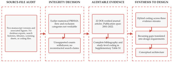
This study uses a review-informed framework-development design with three stages: evidence-record audit and source mapping, thematic coding, and conceptual architecture development. Figure 1 documents the auditable workflow used for this revision.
Figure 1.
Auditable evidence-record and gap-to-design synthesis workflow.
2.1. Evidence-Record Audit and Review Scope
On 22 July 2026, the two supplied manuscript versions and their associated figures were audited. Earlier drafts named Scopus, Web of Science, and IEEE Xplore, but no database exports, search histories, reference-library files, screening sheets, full-text decision logs, or coding matrix were available. The original search dates and strings, fields, coverage, restrictions, export and deduplication procedures, reviewer roles, uncertainty handling, and exclusion decisions therefore cannot be verified.
Accordingly, the previously reported flow (1486 identified records, 356 duplicates, 1130 screened records, 288 full texts, 191 full-text exclusions, and 97 included studies) and its three exclusion categories were withdrawn from the abstract, text, and figure. No retrospective arithmetic, deduplication, or staged-screening claim is retained. This also removes the incomplete parenthetical statement identified by the reviewer.
The traceable evidence base is the 22 DOI-verified journal articles cited here, published from 2001 to 2022. All are English-language journal articles, but this observed characteristic is not an a priori restriction. The corpus contains no conference papers, books or chapters, theses, editorials, notes, or gray literature; their absence likewise does not establish prospective exclusion. Supplementary Tables S1–S3 provide the bibliography, evidence map, coding definitions, and record audit. This is a purposive conceptual synthesis, not a reproducible systematic review.
2.2. Evidence Coding and Thematic Synthesis
The 22 publications were recoded in a hybrid deductive-inductive matrix. Deductive fields reflected three evidence streams: (1) urban-infrastructure digital twins; (2) multi-hazard climate-risk modeling; and (3) infrastructure interdependency and cascading risk. Inductive fields captured study design, context, sector, digital-twin function, hazard focus, dependency or cascade treatment, synthesis contribution, and framework implications. Publications could contribute to multiple streams; the matrix records a primary theme and cross-theme contribution. Entries were checked against the DOI-resolved record and each source’s use in the manuscript (Supplementary Tables S1 and S2).
2.3. Framework Development Approach
Evidence-map patterns were translated into framework requirements through an explicit gap-to-design mapping: fragmented data environments informed the input layer and digital-twin integration core; single-hazard assessment informed the multi-hazard climate-scenario layer; isolated infrastructure sectors informed the interdependency-network layer; static assessment informed the dynamic vulnerability and risk layer; weak adaptation support informed the prioritization engine; and limited iterative updating informed the conceptual feedback loop. This mapping connects the auditable evidence base to the architecture in Section 4; it does not establish comparative effectiveness.
3. Literature Synthesis and Research Gap
3.1. Digital Twin Applications in Urban Infrastructure
Within the 22-source evidence map, built-environment digital-twin studies connect physical assets with semantic models, sensor data, simulation, and life-cycle decisions [8,11]. City-scale studies extend these functions to geospatial representation, governance, visualization, participation, and physical-virtual exchange [9,12,13,14], while energy applications demonstrate operational benchmarking in a defined sector [15]. These contributions are usually asset-, use-case-, or sector-specific and are not organized around multi-hazard climate adaptation. This limitation motivates the proposed cross-sector integration core, multi-source linkage, and planning-oriented outputs.
3.2. Multi-Hazard Climate Risk Modeling
The mapped multi-hazard literature shows that risk can arise from cumulative, interacting, compound, sequential, and connected processes [1,2,3,4,16,17,18,19]. Multi-risk methods support climate-impact assessment [16], hazard interactions can alter triggering and consequences [17], and systematic quantification is needed to represent interrelationships [18]. Compound-event typologies further distinguish combinations of drivers, hazards, and impacts [19]. However, these methods are rarely linked to infrastructure dependencies and service disruption. This gap informs a scenario layer that associates individual and compound hazards, under baseline and future climates, with exposed assets and networks.
3.3. Infrastructure Interdependency and Cascading Risk
The mapped interdependency literature explains how direct disruption can propagate across connected systems. Foundational taxonomies and reviews describe dependency types, modeling approaches, recovery behavior, and resilience [5,6,20]; cascading-failure models show how localized failures amplify system consequences [21]; and vulnerability pathways connect infrastructure, governance, and social conditions [22]. Climate-infrastructure and digital-twin studies add exposure and resilience contexts [4,10], but these strands remain weakly connected to adaptation appraisal. This gap motivates the interdependency-network layer, cascading pathways, and service-continuity indicators used in the dynamic risk assessment.
3.4. Identified Research Gap
Together, the three evidence streams provide necessary but incomplete components for adaptation planning. Digital-twin studies contribute data integration and updating; multi-hazard studies contribute interacting climate scenarios; and interdependency research contributes network propagation and service-disruption logic. No stream alone connects these functions to dynamic vulnerability assessment and cross-sector adaptation prioritization. The resulting design requirements are multi-source interoperability, baseline and future multi-hazard representation, explicit dependency and cascading-failure analysis, service-continuity assessment, transparent adaptation criteria, and iterative scenario updating.
Section 4 translates these requirements into an ordered conceptual workflow from data ingestion and harmonization to multi-hazard and interdependency analysis, dynamic risk assessment, adaptation-oriented decision support, and feedback for scenario re-evaluation. The contribution is the synthesis of these functions within one planning architecture, not the invention or demonstrated implementation of each component. Table 1 summarizes the evidence streams, unresolved limitations, and corresponding framework implications.
Table 1.
Evidence streams, unresolved limitations, and implications for the proposed framework.
4. Proposed Multi-Hazard Digital Twin Framework
4.1. Framework Overview
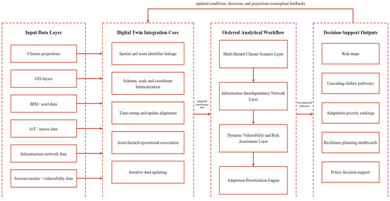
The proposed framework is an ordered, iterative information-processing workflow (Figure 2). Stage 1 ingests climate projections, GIS layers, BIM or asset records, IoT and sensor observations, infrastructure-network data, and socioeconomic vulnerability data. Stage 2 harmonizes and links these sources in the digital-twin integration core. Stages 3–6 pass the integrated information through multi-hazard scenario generation, interdependency analysis, dynamic vulnerability and risk assessment, and adaptation prioritization. Stage 7 returns updated conditions, decisions, and projections to the integration core for scenario re-evaluation. The arrows represent intended data transfers in a future implementation, not an operational or real-time system developed in this study. Table 2 summarizes the information transferred between framework stages.
Figure 2.
Proposed ordered and iterative multi-hazard digital twin framework for climate adaptation planning of interdependent critical urban infrastructure.
Table 2.
Information flow through the proposed framework.
4.2. Data and Integration Layer
The data and integration layer receives climate projections; GIS layers; BIM or asset data; IoT and sensor observations; infrastructure-network topology and service data; and socioeconomic or vulnerability information (Table 3). The integration core conceptually links spatial and asset identifiers, reconciles schemas and semantic definitions, aligns scales, timestamps, and coordinate reference systems, and associates assets with climate exposure and operational condition. The same linkage can incorporate new observations or infrastructure changes. Its output is an integrated asset-hazard dataset transferred to the multi-hazard scenario layer; no platform, data standard, or software implementation is specified.
Table 3.
Main data inputs and their analytical roles.
4.3. Multi-Hazard Climate Scenario Layer
The multi-hazard climate-scenario layer converts climate information into baseline and future scenarios, spatial intensity layers, and individual or compound-hazard combinations. Through identifiers established in the integration core, these fields are associated with infrastructure assets and networks, producing hazard-exposed asset and network states rather than an isolated climate map. These states become inputs to interdependency analysis. Alternative emissions pathways, climate models, downscaling methods, and hazard-interaction assumptions can remain separate for subsequent uncertainty analysis.
4.4. Infrastructure Interdependency Network Layer
The infrastructure-interdependency layer represents critical assets and services as nodes and links. Nodes may denote substations, bridges, reservoirs, pumping stations, hospitals, or transport junctions; links may represent roads, power lines, pipelines, drainage connections, communication channels, or functional service relationships. Physical, cyber, geographic, and logical dependencies are represented conceptually [5]. Combining these dependencies with hazard-exposed assets indicates how direct damage may propagate into indirect service disruption across transport, water, energy, drainage, communication, and emergency-service systems. Outputs are hazard-exposed network states, candidate cascading-failure pathways, and service-continuity implications.
4.5. Dynamic Vulnerability and Risk Assessment Layer
The dynamic vulnerability and risk layer receives hazard intensity and the hazard-exposed network state. It conceptually combines exposure, asset vulnerability, infrastructure criticality, dependency relationships, cascading-impact potential, adaptive capacity, and service-continuity implications. This is an analytical specification, not a calibrated equation. Expected outputs include risk maps or scores, vulnerability patterns, cascading-risk indicators, failure pathways, and service-continuity measures. These outputs are passed to the adaptation-prioritization engine and may be recalculated as scenarios, asset conditions, networks, or observations change.
4.6. Adaptation Prioritization Engine
The adaptation-prioritization engine converts risk outputs into comparative planning information. Candidate actions are assessed against six proposed criteria: risk-reduction potential, infrastructure criticality, cascading-impact potential, feasibility, urgency, and cross-sector benefit (Table 4). Intended outputs are adaptation priority rankings, risk maps, cascading-failure pathways, resilience-planning dashboards, and policy decision support. Operational definitions and stakeholder-derived weights are required before implementation; this study does not rank or empirically compare specific adaptation alternatives.
Table 4.
Adaptation prioritization criteria.
The feedback path closes the workflow conceptually. Adaptation decisions, infrastructure modifications, updated asset conditions, new sensor observations, and revised climate projections can return to the integration core so that linked scenarios are re-evaluated. This is a mechanism proposed for future iterative implementation, not a demonstrated real-time feedback system.
5. Discussion
5.1. Comparison with Related Digital Twin Frameworks
The proposed framework shares foundational functions with prior digital-twin research but combines them for a different planning purpose. Semantic construction and built-environment models emphasize interoperable information, asset synchronization, monitoring, simulation, and life-cycle processes [8,11]. City digital-twin frameworks emphasize geospatial representation, smart-city governance, and physical-virtual exchange [9,12,13], while the Herrenberg prototype demonstrates visualization, simulation, and participatory planning [14]. Critical-infrastructure digital twins address resilience and disruption management [10], and energy twins support sector-specific operational benchmarking [15]. The proposed architecture is broader in cross-sector and multi-hazard scope and includes cascading effects and adaptation prioritization. It is not demonstrably superior: unlike operational or case-study twins, it has not been implemented, calibrated, or empirically validated.
5.2. Interoperability, Data Quality, and Uncertainty
Operationalization would require BIM-GIS-IoT interoperability across incompatible schemas, geometric detail, spatial resolution, coordinate systems, sampling intervals, semantic definitions, asset identifiers, update frequencies, communication protocols, and data-ownership arrangements. Asset inventories may be incomplete, BIM or as-built records outdated, GIS coverage inconsistent, sensors sparse, utility-network data proprietary, and socioeconomic data missing or uneven. Cybersecurity and privacy restrictions, institutional silos, and unclear maintenance responsibilities may further reduce update frequency and reliability. The integration core should therefore retain source metadata, provenance, quality flags, and update histories rather than treating all inputs as equally complete or current.
Climate-risk outputs would also carry uncertainty from emissions pathways, climate models, downscaling, spatial and temporal resolution, hazard-interaction assumptions, future exposure and vulnerability, infrastructure deterioration, and socioeconomic change. A future implementation should preserve scenario ensembles and uncertainty ranges, conduct sensitivity analysis, and, where suitable, report probabilistic outputs instead of a single deterministic risk value or adaptation ranking.
5.3. Validation, Application, and Governance
Validation should proceed in stages: expert and stakeholder review of requirements; interoperability testing; verification of hazard, network, risk, and prioritization modules; retrospective testing against historical disruptions; development of a modular prototype; pilot application to a city or infrastructure corridor; comparison of predicted cascades with observed outcomes; and evaluation of rankings against expert or multi-criteria decisions. None of these activities has been completed. Application would also require interagency agreements, computational resources, model maintenance, governance of shared infrastructure information, and participation by operators, emergency managers, planners, and local authorities. The architecture offers structured conceptual integration, but its usefulness depends on operationalization, data access, stakeholder engagement, and empirical validation.
6. Conclusions
The principal contribution is a review-informed conceptual architecture that connects multi-hazard climate information, infrastructure interdependency, dynamic vulnerability and cascading-risk assessment, adaptation prioritization, and iterative updating through a digital-twin integration core. The 22-source evidence map shows how these functions remain distributed across three research streams and makes the resulting gap-to-design logic explicit. The intended value is to support system-level adaptation planning by making direct asset risk, indirect service disruption, and cross-sector benefits visible within one workflow.
Several limitations define the contribution. No operational digital twin or software prototype was implemented; no city-scale case study was conducted; no module was calibrated; and no adaptation alternative was empirically ranked. The information transfers, service-continuity indicators, and prioritization criteria require operational definition. The original search dates, queries, exports, deduplication record, screening decisions, exclusion reasons, and claimed 97-study corpus could not be recovered. The evidence claim is therefore confined to 22 DOI-verified sources, and database-coverage or screening bias cannot be quantified (Supplementary Tables S1–S3).
Future work should develop a modular prototype; select interoperable BIM-GIS-IoT architectures; integrate climate-model ensembles and uncertainty propagation; implement network-based cascading-failure models; and define, weight, and test adaptation-prioritization methods. A new, prospectively documented literature search should be conducted with saved database queries, exports, deduplication rules, screening decisions, and exclusion logs. A real urban case study should then support sensitivity analysis and validation with historical events, infrastructure operators, and planning stakeholders, followed by assessment of scalability, governance, cybersecurity, privacy, and long-term data maintenance.
Supplementary Materials
The following supporting information can be downloaded at: https://www.mdpi.com/article/10.3390/eesp2026045003/s1, Table S1, Bibliography and Evidence Matrix (22 DOI-verified journal articles); Table S2, Coding Definitions and Decision Rules; and Table S3, Source-Record Audit.
Funding
This research received no external funding.
Institutional Review Board Statement
Not Applicable.
Informed Consent Statement
Not Applicable.
Data Availability Statement
The 22-source DOI-verified bibliography and evidence matrix, coding definitions and decision rules, and source-record audit are provided in Supplementary Tables S1–S3. The original database exports and screening logs were unavailable; no new primary experimental or field data were generated.
Conflicts of Interest
The authors declare no conflict of interest.
References
- Mora, C.; Spirandelli, D.; Franklin, E.C.; Lynham, J.; Kantar, M.B.; Miles, W.; Smith, C.Z.; Freel, K.; Moy, J.; Louis, L.V.; et al. Broad threat to humanity from cumulative climate hazards intensified by greenhouse gas emissions. Nat. Clim. Change 2018, 8, 1062–1071. [Google Scholar] [CrossRef] [Scilit]
- Zscheischler, J.; Westra, S.; Van Den Hurk, B.J.J.M.; Seneviratne, S.I.; Ward, P.J.; Pitman, A.; AghaKouchak, A.; Bresch, D.N.; Leonard, M.; Wahl, T.; et al. Future climate risk from compound events. Nat. Clim. Change 2018, 8, 469–477. [Google Scholar] [CrossRef] [Scilit]
- Raymond, C.; Horton, R.M.; Zscheischler, J.; Martius, O.; AghaKouchak, A.; Balch, J.; Bowen, S.G.; Camargo, S.J.; Hess, J.; Kornhuber, K.; et al. Understanding and managing connected extreme events. Nat. Clim. Change 2020, 10, 611–621. [Google Scholar] [CrossRef] [Scilit]
- Forzieri, G.; Bianchi, A.; E Silva, F.B.; Herrera, M.A.M.; Leblois, A.; LaValle, C.; Aerts, J.C.J.H.; Feyen, L. Escalating impacts of climate extremes on critical infrastructures in Europe. Glob. Environ. Change 2018, 48, 97–107. [Google Scholar] [CrossRef] [Scilit] [PubMed]
- Rinaldi, S.M.; Peerenboom, J.P.; Kelly, T.K. Identifying, understanding, and analyzing critical infrastructure interdependencies. IEEE Control Syst. Mag. 2001, 21, 11–25. [Google Scholar] [CrossRef] [Scilit]
- Ouyang, M. Review on modeling and simulation of interdependent critical infrastructure systems. Reliab. Eng. Syst. Saf. 2014, 121, 43–60. [Google Scholar] [CrossRef] [Scilit]
- Meerow, S.; Newell, J.P.; Stults, M. Defining urban resilience: A review. Landsc. Urban Plan. 2016, 147, 38–49. [Google Scholar] [CrossRef] [Scilit]
- Boje, C.; Guerriero, A.; Kubicki, S.; Rezgui, Y. Towards a semantic Construction Digital Twin: Directions for future research. Autom. Constr. 2020, 114, 103179. [Google Scholar] [CrossRef] [Scilit]
- Shahat, E.; Hyun, C.T.; Yeom, C. City Digital Twin Potentials: A Review and Research Agenda. Sustainability 2021, 13, 3386. [Google Scholar] [CrossRef] [Scilit]
- Brucherseifer, E.; Winter, H.; Mentges, A.; Mühlhäuser, M.; Hellmann, M. Digital Twin conceptual framework for improving critical infrastructure resilience. at–Automatisierungstechnik 2021, 69, 1062–1080. [Google Scholar] [CrossRef] [Scilit]
- Davila Delgado, J.M.; Oyedele, L. Digital Twins for the built environment: Learning from conceptual and process models in manufacturing. Adv. Eng. Inform. 2021, 49, 101332. [Google Scholar] [CrossRef] [Scilit]
- Deng, T.; Zhang, K.; Shen, Z.-J.M. A systematic review of a digital twin city: A new pattern of urban governance toward smart cities. J. Manag. Sci. Eng. 2021, 6, 125–134. [Google Scholar] [CrossRef] [Scilit]
- Li, D.; Yu, W.; Shao, Z. Smart city based on digital twins. Comput. Urban Sci. 2021, 1, 4. [Google Scholar] [CrossRef] [Scilit]
- Dembski, F.; Wössner, U.; Letzgus, M.; Ruddat, M.; Yamu, C. Urban Digital Twins for Smart Cities and Citizens: The Case Study of Herrenberg, Germany. Sustainability 2020, 12, 2307. [Google Scholar] [CrossRef] [Scilit]
- Francisco, A.; Mohammadi, N.; Taylor, J.E. Smart City Digital Twin–Enabled Energy Management: Toward Real-Time Urban Building Energy Benchmarking. J. Manag. Eng. 2020, 36, 04019045. [Google Scholar] [CrossRef] [Scilit]
- Gallina, V.; Torresan, S.; Critto, A.; Sperotto, A.; Glade, T.; Marcomini, A. A review of multi-risk methodologies for natural hazards: Consequences and challenges for a climate change impact assessment. J. Environ. Manag. 2016, 168, 123–132. [Google Scholar] [CrossRef] [Scilit] [PubMed]
- Gill, J.C.; Malamud, B.D. Reviewing and visualizing the interactions of natural hazards. Rev. Geophys. 2014, 52, 680–722. [Google Scholar] [CrossRef] [Scilit]
- Tilloy, A.; Malamud, B.D.; Winter, H.; Joly-Laugel, A. A review of quantification methodologies for multi-hazard interrelationships. Earth-Sci. Rev. 2019, 196, 102881. [Google Scholar] [CrossRef] [Scilit]
- Zscheischler, J.; Martius, O.; Westra, S.; Bevacqua, E.; Raymond, C.; Horton, R.M.; van den Hurk, B.; AghaKouchak, A.; Jézéquel, A.; Mahecha, M.D.; et al. A typology of compound weather and climate events. Nat. Rev. Earth Environ. 2020, 1, 333–347. [Google Scholar] [CrossRef] [Scilit]
- Sun, W.; Bocchini, P.; Davison, B.D. Overview of Interdependency Models of Critical Infrastructure for Resilience Assessment. Nat. Hazards Rev. 2022, 23, 04021058. [Google Scholar] [CrossRef] [Scilit]
- Dueñas-Osorio, L.; Vemuru, S.M. Cascading failures in complex infrastructure systems. Struct. Saf. 2009, 31, 157–167. [Google Scholar] [CrossRef] [Scilit]
- Pescaroli, G.; Alexander, D. Critical infrastructure, panarchies and the vulnerability paths of cascading disasters. Nat. Hazards 2016, 82, 175–192. [Google Scholar] [CrossRef] [Scilit]

Disclaimer/Publisher’s Note: The statements, opinions and data contained in all publications are solely those of the individual author(s) and contributor(s) and not of MDPI and/or the editor(s). MDPI and/or the editor(s) disclaim responsibility for any injury to people or property resulting from any ideas, methods, instructions or products referred to in the content. |
© 2026 by the author. Licensee MDPI, Basel, Switzerland. This article is an open access article distributed under the terms and conditions of the Creative Commons Attribution (CC BY) license.