Review

Advances in Remote Sensing for Tropical Cyclone Impact Assessment in Coastal and Mangrove Ecosystems: A Comprehensive Review


1
Department of Urban and Regional Planning, Chittagong University of Engineering and Technology, Chattogram 4349, Bangladesh
2
Department of Geomatics Engineering, University of Calgary, Calgary, AB T2N 1N4, Canada
*
Author to whom correspondence should be addressed.
Geomatics 2026, 6(2), 29; https://doi.org/10.3390/geomatics6020029
Submission received: 28 February 2026 / Revised: 20 March 2026 / Accepted: 20 March 2026 / Published: 22 March 2026

Abstract

Tropical cyclones rank among the most destructive natural hazards globally, posing significant threats to coastal ecosystems and communities. Mangrove forests, renowned for their ecological importance and coastal protection services, are vulnerable to these disturbances, suffering structural damage, habitat loss, and disruption of vital ecosystem functions. Conventional field-based assessment methods often fall short in capturing the rapid and widespread impacts of cyclones, particularly in remote or cloud-obscured regions. This review aims to provide a comprehensive synthesis of remote sensing applications for monitoring cyclone-induced impacts on mangrove and coastal ecosystems worldwide. Through a systematic literature review of 74 peer-reviewed articles from 1990 to 2025, the study evaluates the utility of optical sensors, radar systems, and multi-sensor platforms in assessing inundation, vegetation damage, and ecosystem service loss. Key methodological advances such as time-series analysis, machine learning, and UAV-based validation are highlighted, alongside critical gaps including limited geographic coverage, weak validation practices, and minimal socio-economic integration. Notably, 75.4% of reviewed studies are concentrated in Asia, with Bangladesh and India alone accounting for 44.6% of the total literature, underscoring a pronounced geographic bias. The findings underscore the need for robust, near-real-time monitoring frameworks that combine satellite technologies with ground data and community engagement. Ultimately, the review advocates for an integrated, multi-sensor, and participatory approach to cyclone resilience, offering valuable insights for future research, disaster response planning, and sustainable mangrove management.

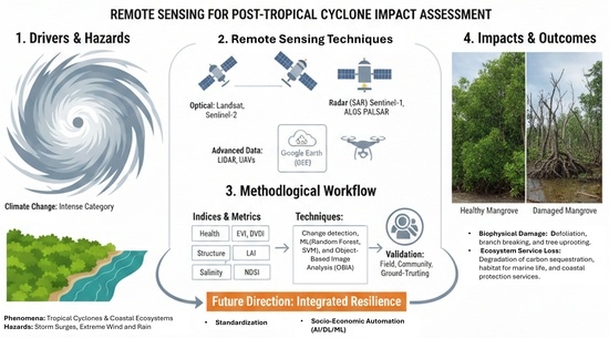
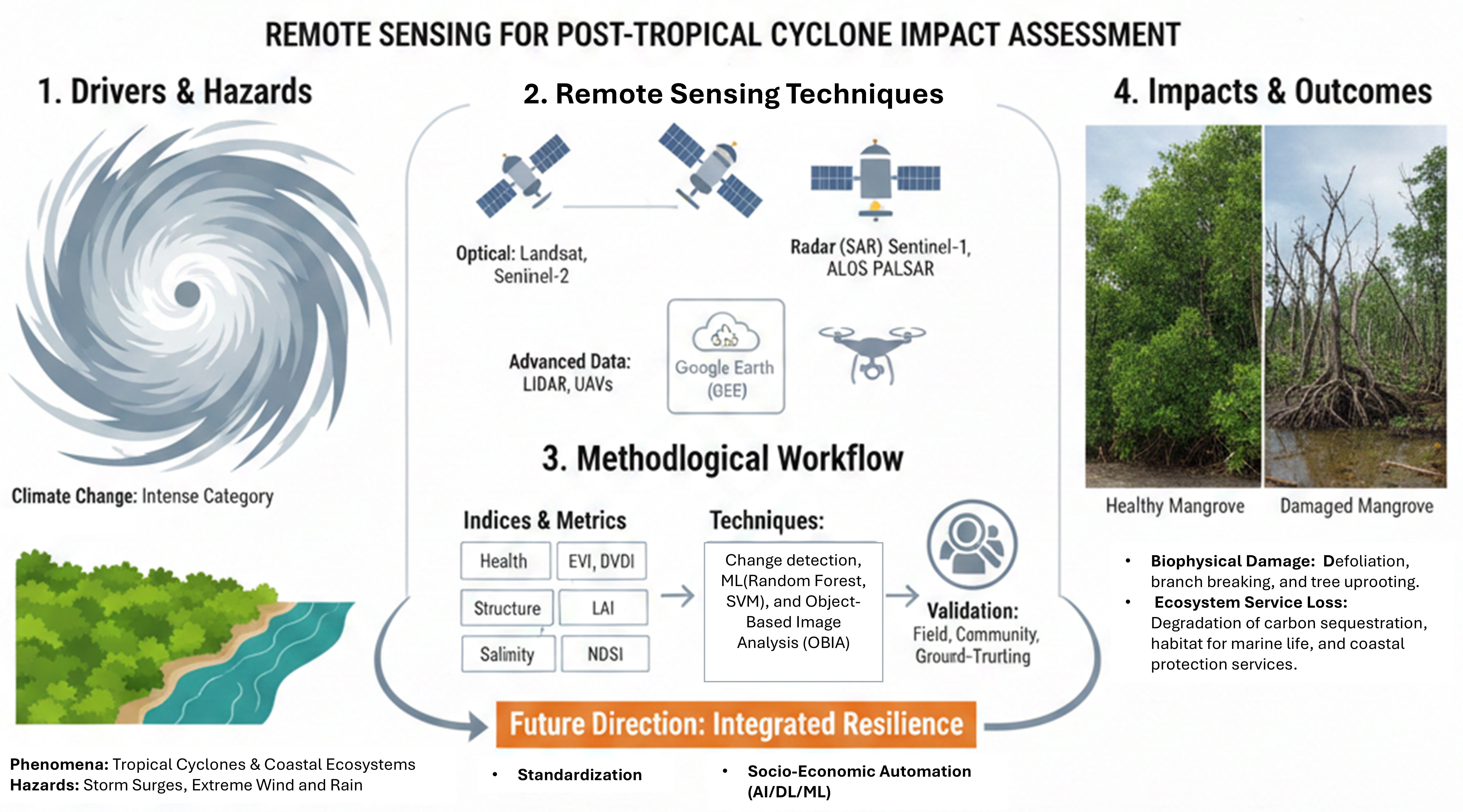
Graphical Abstract

1. Introduction

Tropical coastal ecosystems including mangroves, coral reefs, seagrass, coastal forests, and salt marshes are among the most biologically diverse areas on Earth, supporting numerous species of flora and fauna [1]. These ecosystems provide vital benefits to human society through nutrient cycling, erosion management, fish and crustacean nurseries, water purification, cultural significance, tourism opportunities, and carbon sequestration [2,3,4]. Most importantly, they serve as natural defenses against tropical cyclones [2,3,4]. The protective role of these ecosystems has become increasingly essential as tropical cyclone frequency has risen since the 1980s [5], compounding risks from growing coastal populations and infrastructure [6]. Currently, 21% of people annually impacted by tropical cyclones in low-elevation coastal zones benefit from the protective services of these ecosystems [4].
Among coastal ecosystems, mangroves are particularly effective as natural barriers against tropical cyclones, substantially reducing disaster risk for coastal communities [7,8,9,10,11,12,13,14,15,16,17]. Mangrove forests are distributed across the tropical and subtropical coastal zones of 118 countries [18] (Figure 1), broadly confined between the Tropics of Cancer and Capricorn [19], with a global extent estimated between approximately 138,000 and 147,000 square kilometers [20]. Asia holds nearly 40% of the worldwide coverage [18,21]. These ecosystems consist of halophytic trees and shrubs, comprising approximately 70 recognized species globally that thrive in the intertidal zones of sheltered bays, estuaries, and river deltas [19,22,23]. Specialized root structures such as pneumatophores and prop roots facilitate gas exchange in anoxic soils while simultaneously binding sediment and dissipating wave energy [19,24,25,26]. However, mangrove forests are highly sensitive to climate forcing: sea level rise threatens up to 16% of global mangrove area with submersion by 2050, while tropical cyclones alone account for approximately 45% of reported mangrove area losses through wind throw, uprooting, and defoliation [18,27,28,29,30]. Salinity intrusion driven by sea level rise and altered freshwater flow further compounds these pressures, causing physiological stress and shifts in species composition [31,32]. Research demonstrates that mangrove vegetation can attenuate wave heights by over 75% within just one kilometer of forest cover [33]. Furthermore, empirical evidence shows that these forests effectively lower peak storm surge water levels, thereby protecting coastal communities and infrastructure [20]. This protective capacity is enhanced by mangroves’ ability to trap carbon-rich particles and promote sediment accretion, key regulating ecosystem services that contributes to coastal stability and resilience against erosion and flooding [34].
Despite these protective benefits, recent scientific assessments reveal a concerning trend. Anthropogenic climate change has intensified tropical cyclones, as underscored by the Intergovernmental Panel on Climate Change (IPCC) Sixth Assessment Report (AR6), which links human-induced greenhouse emissions to increased frequency and severity of such events. Paradoxically, while the global frequency of tropical cyclones has shown a declining trend in many observational records and model projections [36,37,38], the threat from intense tropical cyclones particularly those reaching Category 3 or higher has continuously increased [39,40,41,42,43]. Studies project that globally averaged storm intensity could increase by 2–11% by 2100 due to greenhouse warming [44], meaning we can expect more powerful storms as the climate continues to warm.
These intensifying storms pose significant threats to the very ecosystems that protect coastal communities. Tropical cyclones cause extensive damage to mangrove forests through structural damage, functional disruption, and consequent loss of ecosystem services [45,46]. Such damage manifests as defoliation, branch breaking, tree uprooting, reduced photosynthetic activity, and impaired seedling establishment, all of which degrade the forest’s capacity to regenerate and maintain ecological functioning [47]. Additionally, storm-induced damage can trigger peat collapse and carbon sequestration loss, threatening both habitat quality and biodiversity for fish and invertebrate species [27].
To assess and monitor these cyclone impacts, remote sensing technology has emerged as an invaluable tool, with capabilities significantly improving over the past three decades [48,49]. Early studies relied on medium-resolution Landsat imagery, but technological advances by the 2010s introduced high-resolution satellite data and aerial hyperspectral sensors, enabling more precise damage assessments [49,50]. The 2020s have witnessed further innovations, with cloud-penetrating radar and optical sensors now providing near-real-time monitoring of canopy loss, erosion, vegetation damage, and inundation levels [29,51]. Among these technologies, Synthetic Aperture Radar (SAR) has proven particularly valuable for cyclone assessments due to its ability to penetrate cloud cover [52]. Without such technological capabilities, delays in post-disaster response could lead to irreversible ecosystem degradation [29].
However, despite these technological advancements, significant research gaps persist. Current reviews on remote sensing applications in post-cyclone impact assessments remain outdated and overly general, failing to focus specifically on cyclone-induced impacts or the integration of multi-sensor data for dynamic post-disturbance assessment [53]. While many reviews address mangrove monitoring broadly [49,54], they lack targeted analysis of cyclone-specific impacts and multi-sensor integration strategies [55].
Previous reviews have also exhibited notable limitations, with thematic and methodological gaps particularly evident in empirical studies that focus primarily on measuring short-term cyclone effects on forests [25] rather than examining long-term ecosystem alterations [30]. For instance, [56] identified that SAR imagery used for tropical cyclone impact assessment and recovery remained very limited in contemporary studies. Moreover, while numerous studies have examined storm effects on ecosystems, the majority have concentrated on specific relationships between certain species [57], vegetation types [58,59], or regional ecosystems [60], rather than providing comprehensive assessments.
In response to these identified gaps, the field has recently undergone several significant shifts. Traditional dependence on optical satellite imagery has evolved to incorporate SAR and Light Detection and Ranging (LiDAR) technologies, enabling more accurate evaluations even under challenging weather conditions. Simultaneously, platforms like Google Earth Engine (GEE) have democratized access to vast geospatial datasets and computational resources, facilitating rapid analysis and decision-making processes [61]. Recent studies have demonstrated the effectiveness of machine learning techniques and Unmanned Aerial Vehicle-based (UAV) high-resolution imagery in enhancing post-cyclone damage classification and monitoring [62,63]. These technological advancements are influencing a paradigm shift towards ecosystem-based disaster risk reduction, with remote sensing increasingly employed to assess the long-term effectiveness of nature-based interventions [64].
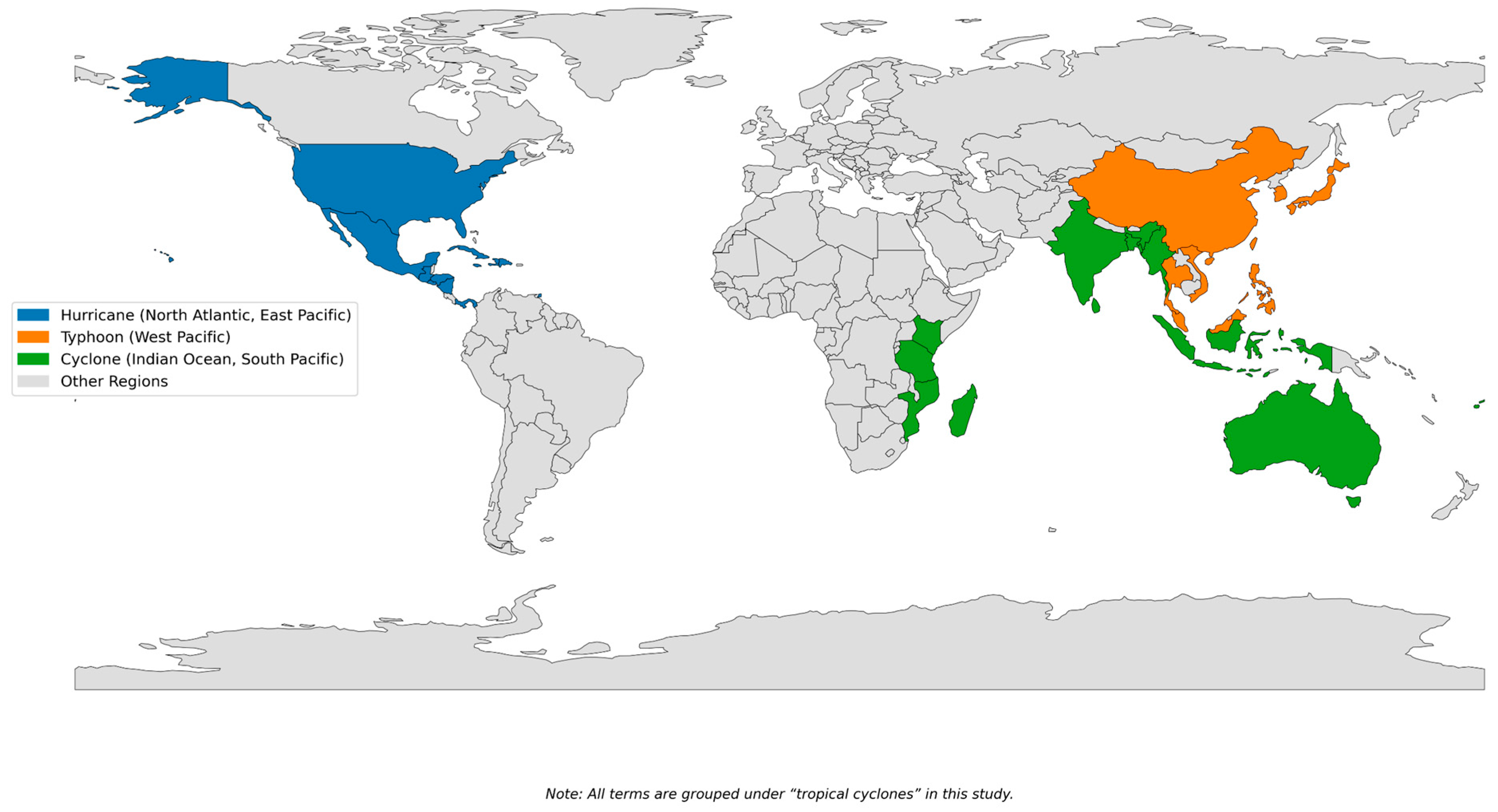
Building on these developments, this review aims to examine and synthesize contemporary advancements in remote sensing technologies as applied to post-tropical cyclone impact assessment in mangrove and coastal ecosystems. Through critical analysis of multi-sensor approaches including optical data (e.g., Sentinel-2, Landsat), SAR (e.g., Sentinel-1, ALOS), and integrated platforms such as GEE and UAV-based systems, this study addresses emerging methodological and application related trends. The study is organized around important questions about the most common methods for identifying cyclone-related impacts such as flooding and vegetation loss, the effectiveness of these methods in capturing ecosystem disruptions, validation approaches for ensuring accuracy, and the application of remote sensing data in ecosystem resilience and policymaking. By addressing these questions, this review provides a structured overview of remote sensing tools and their roles in post-cyclone impact assessment, with particular focus on tropical cyclones across different regions. For clarity, we adopt the unified term “tropical cyclone” throughout. A global map showing the different naming practices for tropical cyclones throughout major ocean basins is presented in Figure 2 to put regional terminologies into context.
This review spans three decades (1990–2025) and encompasses cyclone-affected mangrove and coastal regions globally, integrating ecological, geospatial, and disaster risk reduction perspectives. Specifically, the study pursues four aims: (1) to trace the evolution from single-sensor to multi-sensor remote sensing frameworks for post-cyclone assessment; (2) to evaluate the application of remote sensing indices and algorithms in detecting inundation, vegetation damage, and ecosystem change; (3) to assess the economic implications of cyclone-induced ecological damage to mangrove ecosystems; and (4) to analyze existing frameworks for adaptive resilience planning and ecosystem restoration. Together, these aims provide a structured reference for scholars, practitioners, and policymakers engaged in climate adaptation, remote sensing, and coastal ecosystem management.
Unlike previous reviews that address mangrove remote sensing broadly or focus on single-sensor applications, this review is distinguished by several defining characteristics. First, it specifically targets tropical cyclone-induced impacts rather than general disturbance regimes, providing a focused synthesis that existing broader reviews do not offer. Second, it spans three decades of literature from 1990 to 2025, offering the most temporally comprehensive coverage to date. Third, it systematically evaluates multiple sensor categories including optical, SAR, LiDAR, and UAV-based platforms within a unified analytical framework. Fourth, it explicitly addresses multi-sensor integration strategies as a methodological advancement, rather than treating individual sensors in isolation. Finally, it extends beyond biophysical assessment to encompass ecosystem resilience, economic valuation of ecosystem services, and management and policy implications, thereby bridging the gap between remote sensing science and practical decision-making for coastal communities.

2. Materials and Methods

2.1. Type of Review

This study used a Systematic Literature Review (SLR) technique to locate, evaluate, and gather peer-reviewed material on the use of remote sensing technologies in post-tropical cyclone impact assessment within coastal and mangrove ecosystems. The SLR methodology was chosen to ensure methodological transparency, replicability, and comprehensive coverage of relevant literature across multiple disciplines, including remote sensing, ecology, disaster risk reduction, and coastal management [65]. By following a structured protocol for literature selection, screening, and thematic analysis, the review aims to consolidate fragmented evidence, highlight methodological advancements, and uncover critical knowledge gaps [66]. The SLR framework enables a rigorous examination of the evolving applications of optical, radar, and multi-sensor platforms, while also facilitating an integrative understanding of how remote sensing supports damage detection, ecosystem service assessment, and resilience-oriented decision-making in cyclone-affected regions [49,56,66].

2.2. Search Strategy

To ensure comprehensive coverage of relevant academic literature, a structured search strategy was employed using two widely used academic search platforms: ScienceDirect and Google Scholar. Both platforms were last searched in June 2025. The search focused on peer-reviewed journal articles and reviews published between 1990 and 2025. For Google Scholar, searches were sorted by relevance and the first 100 results per search string were assessed for inclusion, consistent with established SLR practice for handling Google Scholar searches. The search focused on peer-reviewed journal articles, and reviews published between 1990 and 2025. Boolean operators (AND, OR) and targeted keywords were applied in various combinations using the following full search strings: (“tropical cyclone” OR “hurricane” OR “typhoon”) AND (“mangrove” OR “coastal ecosystem”) AND (“remote sensing” OR “satellite imagery” OR “SAR” OR “Sentinel-1” OR “Landsat”); “cyclone damage assessment” AND (“SAR” OR “Sentinel-1” OR “Landsat”); “mangrove degradation” AND “ecosystem services” AND “storm impact”; and “remote sensing” AND “post-disaster monitoring” AND “coastal ecosystems.” Additional filters were applied to include only English-language publications relevant to post-cyclone impact assessment, remote sensing techniques, and resilience-related policy applications in coastal and mangrove ecosystems. The initial search results were screened based on titles and abstracts, followed by a full-text review of selected studies to confirm their methodological and thematic relevance.

2.3. Screening and Selection Process

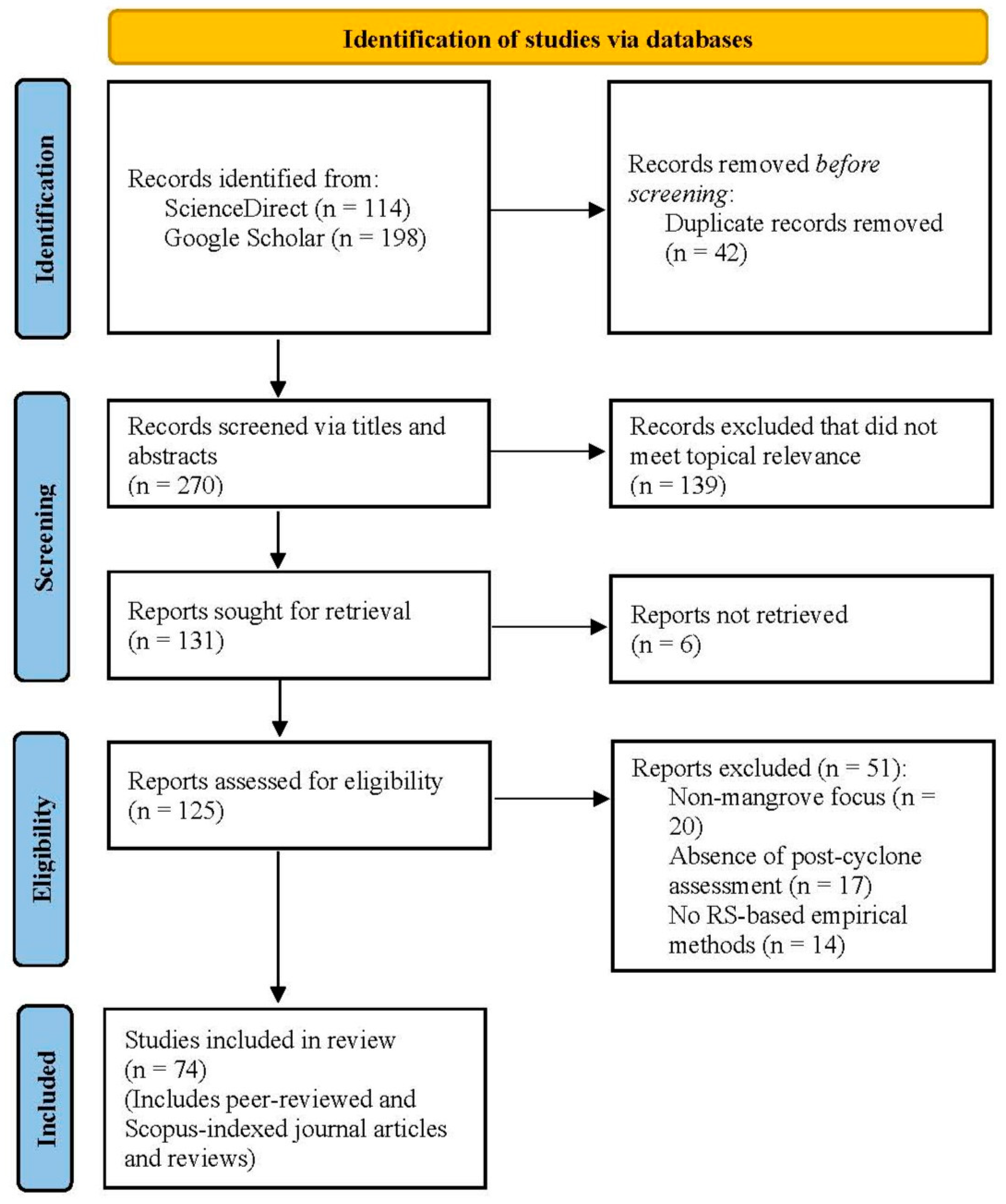
The screening and selection process was conducted in multiple stages to ensure the inclusion of studies that directly addressed the scope of this review (Figure 3). Title and abstract screening were performed independently by two authors, with full-text screening and data extraction subsequently verified by a third author. Disagreements at each stage were resolved through discussion and consensus among the author team. Initially, all records retrieved from ScienceDirect and Google Scholar were screened based on their titles and abstracts to eliminate duplicates, non-English publications, and articles unrelated to tropical cyclones, mangrove ecosystems, or remote sensing applications. In the second stage, the full texts of potentially relevant studies were reviewed to assess their methodological alignment with the review objectives, particularly those employing satellite-based remote sensing, SAR, optical imagery, or UAV technologies in the context of post-cyclone impact assessment. Studies focusing exclusively on terrestrial forest ecosystems or those lacking a spatial analysis component were excluded. Additional backward citation tracking was used to identify seminal and supplementary articles missed during the initial search. The final selection included only peer-reviewed studies that provided empirical data, methodological insights, or conceptual contributions relevant to the post-cyclone impact assessment of mangrove and coastal ecosystems using remote sensing techniques.

2.4. Data Extraction and Thematic Analysis

A structured data extraction protocol was employed to systematically collect and categorize information from the selected studies. For each article, key attributes were recorded, including publication year, geographical coverage, cyclone terminology and classification, types of remote sensing sensors used (optical, radar, multispectral), data sources, analytical methods, ecological impact categories, and validation techniques. The extracted data were organized thematically to correspond with the planned structure of the results section. First, conceptual background elements were reviewed, including the definitions of tropical cyclones, mangrove and coastal ecosystems, and the role of climate change and hydrometeorological drivers. Second, physical, hydrological, biological, and ecosystem service-related impacts of tropical cyclones on mangrove forests were classified. Third, the review examined prior applications of remote sensing in post-cyclone assessment, focusing on sensor types, inundation mapping, vegetation damage detection, and multi-sensor integration methods. Fourth, validation strategies were analyzed across studies, including field observations, UAV-based data, community-driven approaches, and accuracy assessment techniques. Fifth, the review synthesized findings related to the economic valuation of mangrove ecosystem services following cyclone events. Finally, critical gaps and limitations were identified such as geographic bias, underuse of high-resolution datasets, limited socio-economic integration, and weak standardization before advancing toward a framework for integrated resilience assessment. This thematic categorization enabled a coherent synthesis of diverse methodologies and findings while providing a foundation for comparative analysis and future research direction.

2.5. Inclusion/Exclusion Criteria

The study followed the Preferred Reporting Items for Systematic Reviews and Meta-Analyses (PRISMA) 2020 guidelines [65] as shown Figure 3, employing a four-stage screening process: identification, screening, eligibility, and inclusion. During the identification stage, a total of 312 records were retrieved through keyword-based searches from ScienceDirect and Google Scholar. After removing 42 duplicate records, 270 articles proceeded to the screening phase.
The study screened titles and abstracts, excluding 139 records that were not relevant, and assessed 125 full-text articles for eligibility based on methodological fit, study objectives, and evidence quality. Articles were excluded for reasons including non-mangrove focus, absence of post-cyclone assessment, and reliance on conceptual models without remote sensing components (n = 51). Only peer-reviewed and Scopus-indexed journal articles and review papers were included in the final synthesis; conference proceedings, thesis, non-English publications, and articles without empirical geospatial methodologies were excluded. In total, 74 studies were included in the final review. This rigorous selection process ensured that only studies with direct relevance to post-cyclone impact assessment in mangrove and coastal ecosystems using remote sensing technologies were synthesized. It should be noted that no formal quality assessment tool, such as the Critical Appraisal Skills Programme (CASP) checklist or equivalent instrument, was applied to the included studies. This is acknowledged as a methodological limitation of the present review and is an area recommended for incorporation in future systematic reviews on this topic.

3. Results

The comprehensive analysis of post-tropical cyclone impacts in coastal and mangrove ecosystems has been significantly advanced by recent developments in remote sensing and geospatial technologies [19,22,29,48,51,55,56,63,67,68]. Leveraging the unique capabilities of various satellite-based sensors, including optical (e.g., Landsat, Sentinel-2, MODIS), SAR, and LiDAR data, along with cloud-computing platforms like GEE, these approaches enable cost-effective, synoptic, and multi-temporal monitoring of diverse environmental changes [19,22,23,29,48,49,51,53,55,56,63,68,69,70,71,72]. This section presents a systematic review of tropical cyclone impacts on mangrove and coastal ecosystems, evaluates remote sensing techniques, evaluates ecosystem services, identifies gaps in the literature, and proposes an integrated framework for enhancing resilience.

3.1. Conceptual Background

Tropical cyclones represent formidable atmospheric phenomena characterized by intense rotary wind systems and low atmospheric pressure centers, primarily originating over warm tropical marine environments [73]. These systems, known regionally as hurricanes in the Atlantic and northeastern Pacific or typhoons in the northwestern Pacific (Figure 2), are identified by their warm-core intense low-pressure system approximately 1000 km in diameter, closed surface wind circulation, and strong convection patterns [28,55,74]. The genesis of these powerful weather systems requires specific environmental conditions: sea surface temperatures exceeding 26.5 °C to a depth of approximately 50 meters, adequate distance from the equator (typically 4–5 degrees latitude) for significant Coriolis force, and low vertical wind shear [74]. When maximum sustained wind speeds reach or exceed 119 km/h, these systems achieve tropical cyclone strength [74].
The increasing frequency and intensity of these atmospheric phenomena have become particularly concerning in the context of climate change [44,70,75,76]. Future projections consistently suggest that greenhouse warming will lead to a global average shift towards stronger storms, potentially increasing intensity by 2–11% by 2100 [44].
These intensifying tropical cyclones pose significant threats to coastal areas including low-lying and deltaic regions situated at the land–sea interface that serve as vital buffers against natural hazards while supporting billions of people through indispensable environmental and economic services [67,77,78]. The inherently dynamic nature of these regions makes them highly susceptible to climatic and environmental stressors [24]. Among the most vulnerable yet valuable components of coastal ecosystems are mangrove forests which are halophytic plant assemblages thriving in tropical and subtropical coastal and intertidal habitats [28,31,32,53,72]. These dense forests of salt-tolerant trees and shrubs are uniquely adapted to dynamic coastal wetland conditions and provide crucial ecosystem services including carbon sequestration, coastal erosion control, and habitat provision for diverse marine life [18,22,24,53,72,79,80].
When tropical cyclones make landfall, they unleash multiple hazardous impacts on these coastal and mangrove ecosystems [81]. Direct cyclonic winds cause immediate physical damage including defoliation, branch breakage, uprooting, and snapped stems, leading to significant changes in forest structure and composition [66]. Beyond wind damage, cyclone-induced storm surges, flood inundation, and saltwater intrusion inflict substantial ecological damage and land degradation [80,82]. Rising sea levels, recurrent storm surges, and changing wave conditions further compound these impacts, enhancing ecosystem vulnerabilities [18,24].
The complex nature of these impacts on ecosystem services necessitates structured assessment frameworks [51,75]. Ecosystem resilience defined as the capacity of an ecosystem to continue providing services despite environmental disruptions is typically evaluated through comparative analysis of pre- and post-hazard conditions in a spatially explicit manner [83]. The Ecosystem Service Supply Proficiency (ESSP) framework integrates quantitative scores of service supply with data on areal loss and gain to map resilience, allowing for multi-faceted evaluation of cyclone impacts across different temporal phases of disaster events [83]. Similarly, the Driver, Pressure, State, Impact, and Response (DPSIR) framework systematically categorizes stressors and responses within socio-ecological systems [32].
To effectively monitor and assess these multifaceted impacts across vast coastal landscapes, remote sensing and geospatial technologies have become indispensable tools [19,50]. Traditional fieldwork often fails to detect, quantify, and analyze landscape changes due to limitations in spatial and temporal coverage, making the synoptic, multi-temporal views provided by satellite data particularly valuable [50]. The rapid availability of satellite imagery and continuous advancements in processing techniques have significantly enhanced their utility for post-cyclone impact assessment [56]. These technologies enable detection of land use and land cover (LULC) changes before and after cyclonic events, identifying alterations such as increased water bodies, agricultural damage, and vegetation destruction [76].
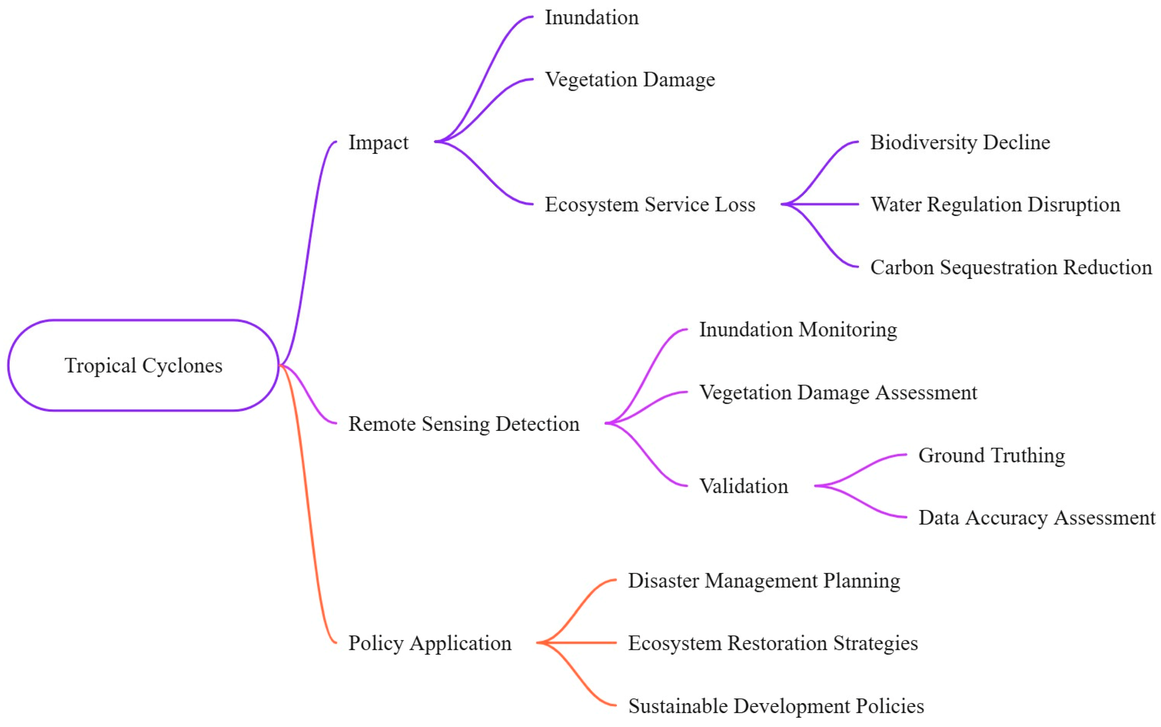
To systematically guide the structure and thematic flow of this review, Figure 4 presents a conceptual framework that illustrates the logical pathway from tropical cyclone occurrence through impact assessment to policy application. This framework demonstrates how cyclone-induced impacts including inundation, vegetation damage, and ecosystem service loss necessitate remote sensing detection methods for inundation monitoring and vegetation damage assessment, which require validation through ground truthing and data accuracy assessment, ultimately enabling policy applications in disaster management planning, ecosystem restoration strategies, and sustainable development policies.

3.2. Impacts of Tropical Cyclones on Mangrove Forests

3.2.1. Physical and Hydrological Impacts

Tropical cyclones inflict substantial physical and hydrological damage on coastal and mangrove ecosystems, primarily through extreme precipitation, high wind speeds, and storm surges [27,28,56,73,80]. These forces frequently lead to significant flood inundation [29,63,70,73,76,80], often exacerbated by embankment breaches that allow saltwater from the sea to infiltrate mangrove forests, increasing soil salinity [80]. Cyclone Yaas, for instance, caused considerable ecosystem loss in Bhitarkanika National Park due to such extreme weather conditions [80]. Coastal erosion is another prominent impact, resulting in shoreline shifting and changes in coastal geomorphology [51,73,76,78,80]. Cyclone Nisarga notably caused erosion across 56.32% of the Maharashtra coastline, while Cyclone Amphan led to severe erosion with over 68% of transects showing signs of retreat [78,84]. Beyond direct inundation and erosion, tropical cyclones significantly alter sediment dynamics [24,28,51,75,78,83]. While excessive sediment deposition can bury aerial roots, limit oxygen exchange, and induce anoxia and mortality [28,51], moderate sediment inputs, especially those rich in nutrients, can paradoxically stimulate plant growth and contribute to immediate gains in soil surface elevation, particularly in nutrient-poor environments [25,28,29]. The complex interplay between wind, waves, currents, and sediment transport dictates the erosive capacity of these events [78], while ponding of high-salinity storm surge is identified as a critical driver of mangrove dieback and reduced ecosystem resilience [25,29,51]. Furthermore, pre-existing hydrological modifications can severely compromise the ecosystem’s ability to regenerate post-cyclone [28].

3.2.2. Biological and Ecological Impacts

Tropical cyclones significantly damage mangrove forests through defoliation, branch breakage, tree uprooting, and snapped stems, ultimately causing widespread damage to vegetation structure and composition [20,28,29,51,66,72,83,85]. These immediate physical impacts subsequently lead to significant alterations in overall forest structure and species composition [66,83], with the severity of such damage being closely linked to wind speed, particularly in cyclones exceeding Category 3 intensity (≥178 km/h), where extreme visible effects become almost universal [28,51,75]. However, the extent of this damage is not solely determined by cyclone intensity; rather, initial system properties including stand characteristics, tree species, stem density, and the forest’s structural complexity (e.g., canopy height, density, and presence of aerial roots) play a crucial role in mediating these impacts [20,25,28,29,51,85]. Despite experiencing such severe damage, mangrove ecosystems are generally considered highly resilient [25,28,83,86], as evidenced by their rapid recovery mechanisms such as coppicing and resprouting (e.g., Avicennia, Sonneratia, Excoecaria, Lumnitzera, and Laguncularia species) or reliance on advance regeneration through pre-existing seedlings [28,51]. Nevertheless, this inherent resilience and recovery capacity can be severely compromised under certain conditions, specifically when recurrent intense cyclones reduce recovery time between disturbances [27,29,51,75,83], or when long-term environmental stressors compound the cyclone impacts [25,51]. Consequently, while recovery is typical in most cases, some areas may experience permanent damage or shifts to alternative ecosystem states when conditions become unfavorable for mangrove reestablishment, representing the most severe outcome of cyclone–mangrove interactions [51].

3.2.3. Ecosystem Service Disruptions

Tropical cyclones significantly disrupt the array of vital ecosystem services provided by mangroves, impacting both environmental stability and human well-being. A primary service affected is coastal protection and disaster risk reduction [4,20,24,27,28,30,31,32,50,87]. Mangroves function as natural bio-shields, effectively dissipating wave energy (up to 66% within the first 100 m of forest width) and reducing storm surge peak water levels (ranging from 5 to 50 cm per km of mangrove width) [4,20,24,28,87]. This protective capacity is critical, as evidenced by studies showing reduced death tolls and economic impacts in areas with intact mangrove forests [24]. Carbon sequestration, a crucial climate mitigation service, is also highly vulnerable [24,27,30,53]. Mangroves are among the world’s most carbon-rich forests [26,28], but cyclone-induced defoliation and biomass loss can lead to temporary reductions in above-ground carbon stocks [28,51]. In severe cases, particularly with recurrent intense storms, this can result in peat collapse and permanent carbon export, diminishing the ecosystem’s long-term carbon storage potential [27,28,51]. Additionally, tropical cyclones disrupt fishery habitat provisioning [27,30,31,32,49,80,88], as mangroves serve as essential nurseries and breeding grounds for diverse marine life [80]. Degradation and changes in forest structure can lead to biodiversity loss and diminished ecosystem services [32], including consequences like fish mortality due to altered water chemistry from organic matter decomposition [66]. Beyond these, cyclones can impact provisioning services (e.g., food, timber, fuelwood, medicine) [20,31,32,88] and cultural services (e.g., tourism, worship, educational research) [30,32,49,83,88], ultimately leading to significant socioeconomic losses and impacts on the livelihoods of dependent coastal communities [32,73,77].

3.3. Remote Sensing Techniques for Post-Cyclone Assessment on Previous Work

3.3.1. Overview of Satellite Sensors Used

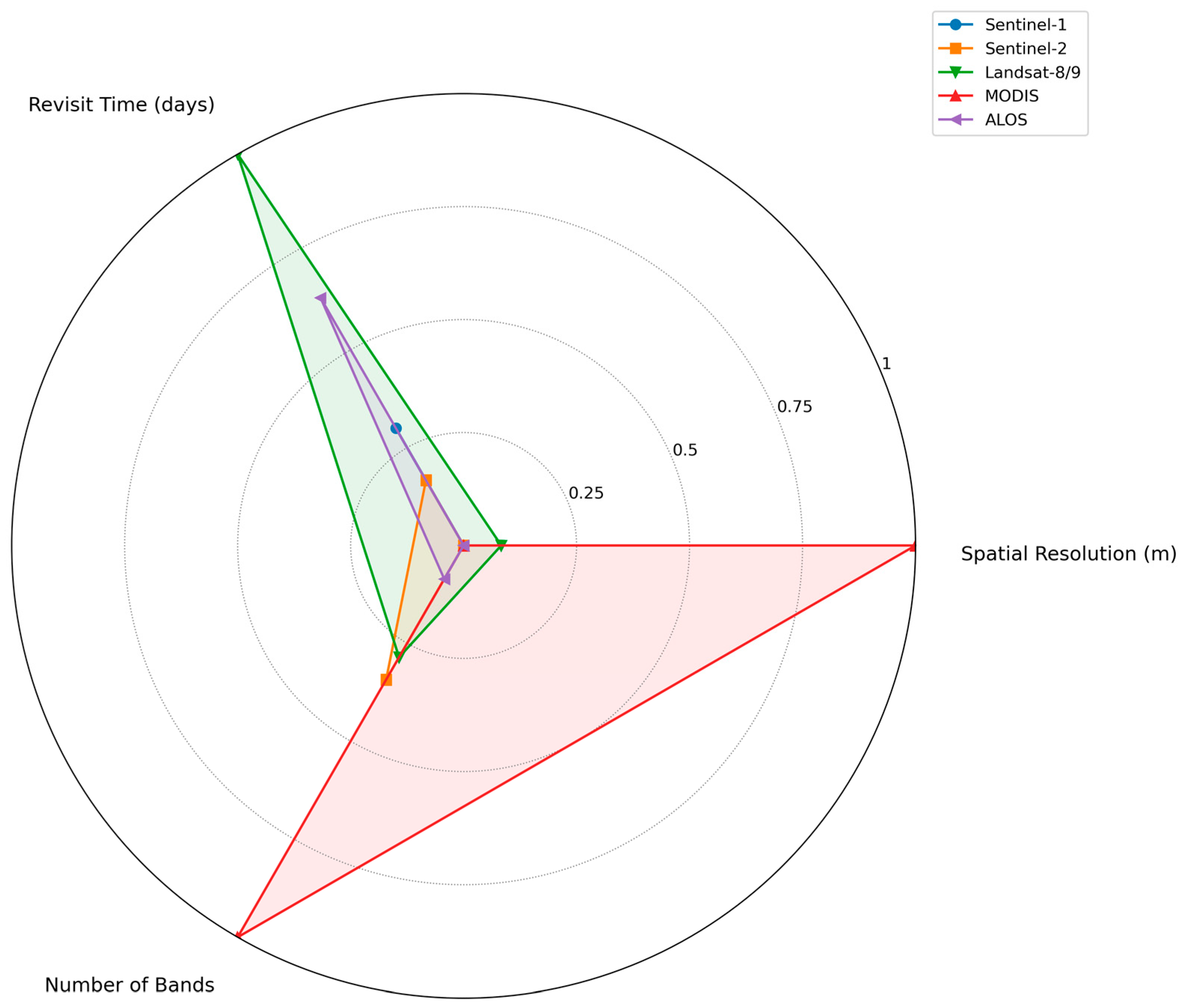
Post-tropical cyclone impact assessments in coastal and mangrove ecosystems heavily rely on a diverse array of satellite sensors, each offering unique capabilities tailored to specific monitoring needs. Optical sensors, such as Landsat and Sentinel-2, are frequently utilized for their ability to provide multi-temporal, moderate to high spatial resolution imagery [25,29,51,66,67,72,76,81,83,89]. Landsat, with its 30 m spatial resolution and 16-day revisit time, has been instrumental in long-term monitoring [25,53,67,72]. Sentinel-2, boasting a finer 10 m spatial resolution and a 5-day revisit cycle, is particularly valuable for detailed vegetation damage assessment and LULC mapping, with its red-edge bands proving beneficial for distinguishing mangrove species [50,53,67,70,80,90,91]. Figure 5 compares key attributes of remote sensing platforms commonly used in post-cyclone impact assessments. However, optical imagery’s utility is often hampered by persistent cloud cover during and immediately after cyclone events [29,56,70,72,89,90,91,92].
To overcome these limitations, radar sensors, particularly SAR like Sentinel-1 and Advanced Land Observing Satellite (ALOS) Phased Array type L-band Synthetic Aperture Radar (PALSAR), are indispensable due to their all-weather, day-and-night imaging capabilities and their ability to penetrate clouds and even dense vegetation canopies [19,23,29,50,53,56,70,92,93]. Sentinel-1, offering dual-polarization (Vertical-Vertical (VV) and Vertical-Horizontal (VH)) data at 10 m spatial resolution with a 6-day temporal resolution, is widely applied for flood inundation analysis and delineating affected areas [29,70,80,90,93]. ALOS PALSAR (L-band) is notable for its deeper canopy penetration, making it more effective for assessing flooded vegetation and estimating mangrove biophysical parameters like biomass [29,53]. While SAR provides critical structural details often obscured from optical view, it can be affected by speckle noise and may suffer from saturation at higher biomass levels for estimation purposes [23,53,93]. Table 1 shows the overview of major remote sensing platforms employed in the reviewed studies, categorized by their specific application domains in cyclone impact assessment.
Beyond optical and radar, other specialized sensors contribute significantly. LiDAR systems, whether airborne or spaceborne (e.g., National Aeronautics and Space Administration’s (NASA’s) Advanced Spaceborne Thermal Emission and Reflection Radiometer (ASTER) Global Emissivity Dataset (GED)), are crucial for producing precise bathymetric maps, assessing mangrove canopy height, and estimating biomass and 3D (Three-Dimensional) forest structure [25,29,48,50,53,72]. Thermal infrared sensors (e.g., Landsat Thermal InfraRed Sensor (TIRS)) are used to retrieve land surface temperature and soil moisture [48,89]. Passive microwave radiometers (e.g., Soil Moisture Active Passive/Soil Moisture and Ocean Salinity (SMAP/SMOS), microwave imagers/sounders on Fengyun-3E (FY-3E)) provide continuous, wide-swath observations that can detect rapid intensification events in tropical cyclones, measure ocean salinity, and provide atmospheric temperature profiles [48,55,68]. Scatterometers (e.g., Meteorological Operational Advanced SCATterometer (MetOp ASCAT)) deliver surface wind speed and direction data, crucial for capturing tropical cyclone surface wind field evolution [48,55,68]. The integration of these diverse sensor types and their derived products, is essential for a comprehensive and efficient post-cyclone impact assessment, offering macro-spatial and multi-temporal views unattainable through traditional field methods alone [19,25,29,50,63,69,70,77,80,90,92,93].

3.3.2. Inundation Mapping Methods

The detection and mapping of cyclone-induced inundation are critical for rapid disaster response and recovery, with remote sensing providing robust methodologies. SAR-based water detection is particularly effective, as SAR systems can penetrate clouds and acquire imagery regardless of weather conditions, which is crucial during and immediately after a cyclone [19,29,52,70,92,93]. The fundamental principle involves identifying areas with low backscatter values, which typically correspond to smooth water surfaces, distinguishing them from higher backscatter land features [70,92,93]. Sentinel-1 SAR data, specifically the VH polarization, is widely used for flood inundation analysis, as it is sensitive to water and double bounce scattering in flooded regions [70]. However, a challenge with SAR can be differentiating water from other smooth surfaces, or detecting water under dense forest canopies, where L-band SAR (like ALOS PALSAR) generally performs better than C-band [29,92,93].
Optical change detection approaches are also extensively employed, particularly when cloud-free imagery is available. These methods rely on the distinct spectral characteristics of water bodies, leveraging various water indices for delineation. Normalized Difference Vegetation Index (NDWI) and its modified version, MNDWI, are commonly used to detect water features and monitor flooded areas [70,73,77,78,80,92,94]. MNDWI, in particular, has been shown to effectively delineate open water features and enhance their presence in remotely sensed digital imagery, revealing shifts in water spread post-cyclone [73,80,90].
Both SAR and optical data utilize thresholding and classification algorithms to accurately delineate flood extents [29,77,80]. The Otsu algorithm is a widely adopted automated statistical approach for optimal thresholding, identifying the best value to separate flooded and non-flooded pixels based on histogram distribution of backscatter or spectral values [29,70,80,90,92,93]. This method offers high overall accuracy and efficiency [80,93]. Further refinements often include masking out permanent water bodies, removing areas with high slopes, and eliminating isolated small pixel patches to minimize misclassifications [70,92]. Change detection methods calculate the difference in pixel values between pre- and post-flood images, applying a threshold to identify changed areas [29,56,92]. Additionally, classification techniques, both unsupervised (e.g., K-means clustering) and supervised (e.g., Random Forest, Support Vector Machine), are used to categorize pixels into flooded and non-flooded classes [69,92,93]. A novel zero-flood depth method has been developed to refine flood maps by removing overestimated flooded areas caused by smooth impervious surfaces, significantly improving mapping accuracy [92]. The GEE cloud computing platform facilitates much of this analysis, providing access to vast archives of satellite data and computational resources for large-scale, near-real-time flood mapping [29,63,69,70,80,90,92,93].

3.3.3. Vegetation Damage Assessment

Quantifying vegetation impacts from tropical cyclones using remote sensing is achieved through various techniques, primarily revolving around the application of vegetation indices and multi-temporal analysis. The Normalized Difference Vegetation Index (NDVI) is a cornerstone for assessing vegetation health, greenness, and photosynthetic activity, with higher values indicating healthier, denser vegetation [18,21,25,29,63,67,69,72,73,77,78,80,81,88,89,91]. Cyclone-induced damage is often characterized by a significant drop in NDVI values below a certain threshold [25,91]. The Enhanced Vegetation Index (EVI) is another widely used index, offering improved sensitivity to changes in dense canopies and reduced atmospheric/soil background influences, making it ideal for monitoring vegetation conditions and damage [69,73,77,78,80,85,91]. Table 2 summarizes the most frequently used vegetation and damage indices in cyclone-related remote sensing studies, along with their calculation methods, specific applications, strengths and weaknesses.
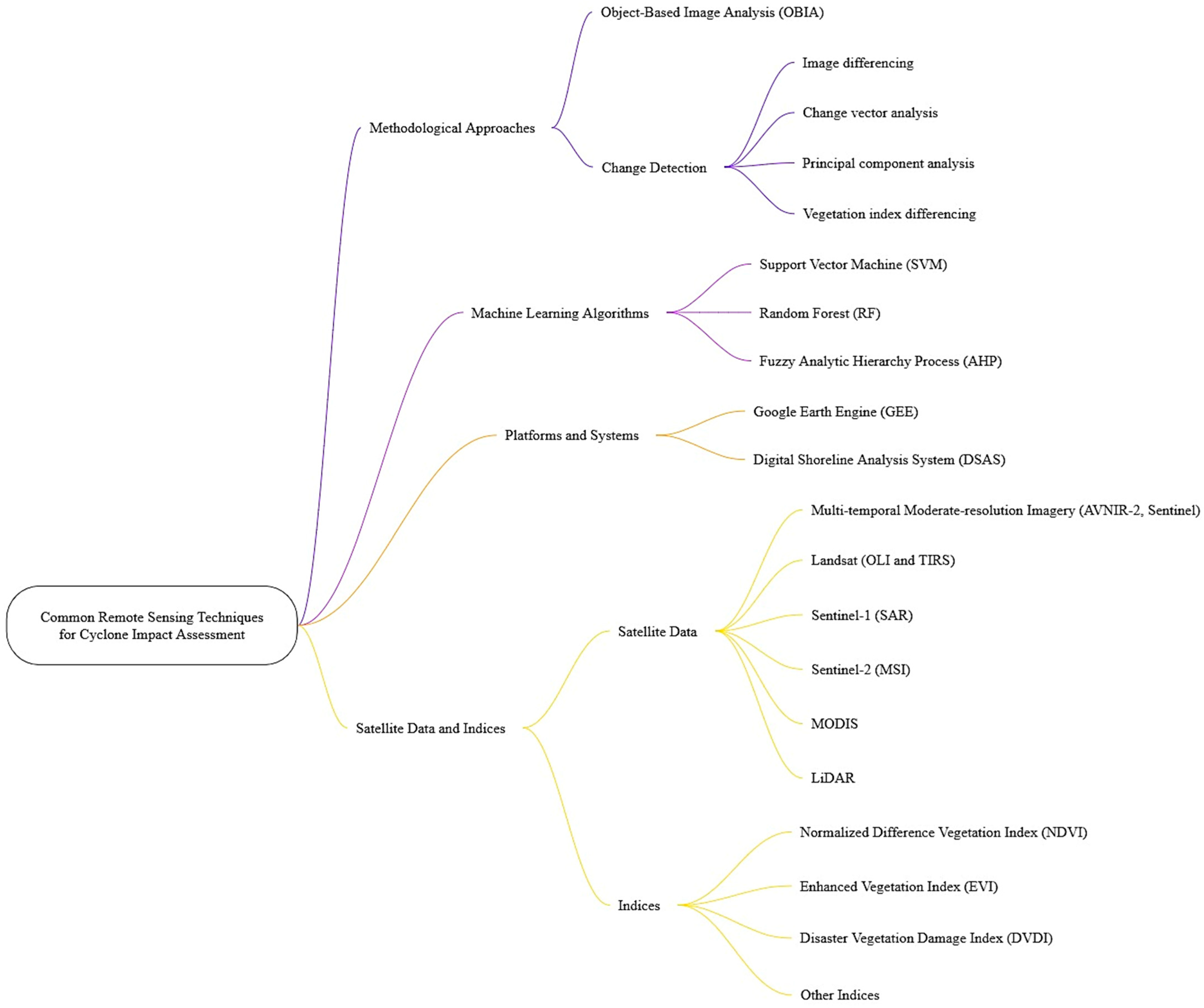
For more specific and nuanced damage assessment, several specialized indices have emerged. The Disaster Damage Vegetation Index (DVDI) quantifies the immediate effects of cyclones by comparing vegetation health before and after the event, categorizing damage into multiple severity levels [69,73,77]. A negative DVDI value indicates tree damage, while a positive value suggests minimal or no impact [69,77]. Similarly, the Modified Vegetation Condition Index (mVCI) refines health assessment by using median NDVI values to mitigate atmospheric interference, providing insights into post-cyclone vegetative stress relative to historical norms [69,73,77]. Indices like DNDVI (Difference NDVI) and ΔEVI (Change in EVI) directly quantify the difference in vegetation indices between pre- and post-cyclone imagery to detect damage [29,69,78,91]. Changes in Leaf Area Index (LAI) are also crucial, correlating with critical ecosystem functions and serving to quantify vegetation structural changes [25,53,80,85]. Furthermore, the Normalized Difference Salinity Index (NDSI) is specifically used to delineate the impact of saltwater intrusion on mangrove forests, indicating increased soil salinity post-cyclone [63,80]. Figure 6 synthesizes these methodological approaches into a workflow diagram, categorizing remote sensing techniques based on sensor type, processing methods, and indices.
Multi-temporal or time-series analysis is fundamental, enabling the comparison of vegetation conditions across different disaster phases (e.g., pre, post, short-term, and long-term recovery) [19,50,51,67,69,83,85]. This approach is vital for tracking recovery trajectories and understanding the long-term ecological resilience of affected areas [51]. Methods for classifying damage severity across impacted areas range from pixel-based analysis to more advanced OBIA (Object-Based Image Analysis) [50,56,69,72,83,95]. OBIA is particularly advantageous for high-resolution imagery and wetland environments, as it considers spatial neighborhood properties and can reduce spectral noise, offering more accurate and meaningful landscape-level damage assessments compared to traditional pixel-based methods [50,72]. Machine learning classifiers, such as Random Forest and Support Vector Machine, are increasingly used for their high accuracy in damage assessment, especially when integrated with predictors like Fractional Vegetation Cover [53,69,76]. However, these methods can be computationally intensive and sensitive to the temporal consistency of cloud-free image acquisition, which remains a persistent challenge in cyclone-prone regions [69,91].

3.3.4. Multi-Sensor and Multi-Resolution Data Integration

The integration of data from multiple satellite platforms and sensors has become a paramount strategy in remote sensing for post-cyclone impact assessment, primarily driven by the need to overcome the inherent limitations of individual sensor types and provide a more comprehensive understanding of complex environmental changes [23,29,50,53,56,70,90,92,93]. This multi-sensor fusion approach leverages the complementary strengths of different data sources, such as combining optical imagery (e.g., Sentinel-2, Landsat) with SAR data (e.g., Sentinel-1, ALOS PALSAR) [23,29,50,53,70,72,80,90,92,94]. For instance, while optical sensors offer detailed spectral information for vegetation health and land cover mapping, their utility is compromised by persistent cloud cover during cyclone events [29,70,90,92]. SAR data, on the other hand, can penetrate clouds and dense vegetation, providing crucial information on inundation and structural damage regardless of weather conditions [23,50,70,92].
The methodological advantages of such integration are numerous. Studies show that combining SAR and optical data can improve the accuracy of mangrove extraction and damage classification compared to using single data sources [23,94]. For example, the introduction of VV polarization mode in an Optical and SAR images Combined Mangrove Index (OSCMI) significantly improved mangrove recognition rates [23]. Also, data fusion provides improved temporal depth and continuity, particularly vital in disaster scenarios where immediate cloud-free optical imagery is scarce [23,29,50,56,70,90,92]. The continuous acquisition by some microwave radiometers (e.g., SMAP/SMOS) can offer a daily view of a storm, supporting the detection of rapid intensification events [68]. It enables a more comprehensive understanding of the multi-faceted impacts by integrating physical (e.g., flood inundation, shoreline changes), biological (e.g., vegetation vigor, biomass loss), and ecological (e.g., ecosystem service disruptions) indicators [70,80]. This holistic approach facilitates better long-term monitoring and reduces reliance on costly and spatially limited field surveys [19,28,50,51,63,69,72,81].
Despite these significant advantages, challenges associated with data fusion persist. One primary challenge is data availability, particularly for high-resolution or specialized datasets like free L-band SAR data [29]. Resolution mismatch between different sensors (e.g., varying spatial, spectral, and radiometric resolutions) can complicate integration and analysis, often requiring sophisticated processing techniques [53,72]. Also, the inherent noise and limitations of individual sensors (e.g., SAR speckle noise, optical cloud obscuration) must be carefully addressed during the fusion process [23,29,70,92,93]. Moreover, the overall data processing complexity for integrating diverse datasets often necessitates powerful cloud computing platforms like GEE and advanced machine learning algorithms, which can be computationally intensive [63,69,80,90,92].

3.4. Validation and Ground-Truthing Techniques on Previous Work

3.4.1. Field Observation and Surveys

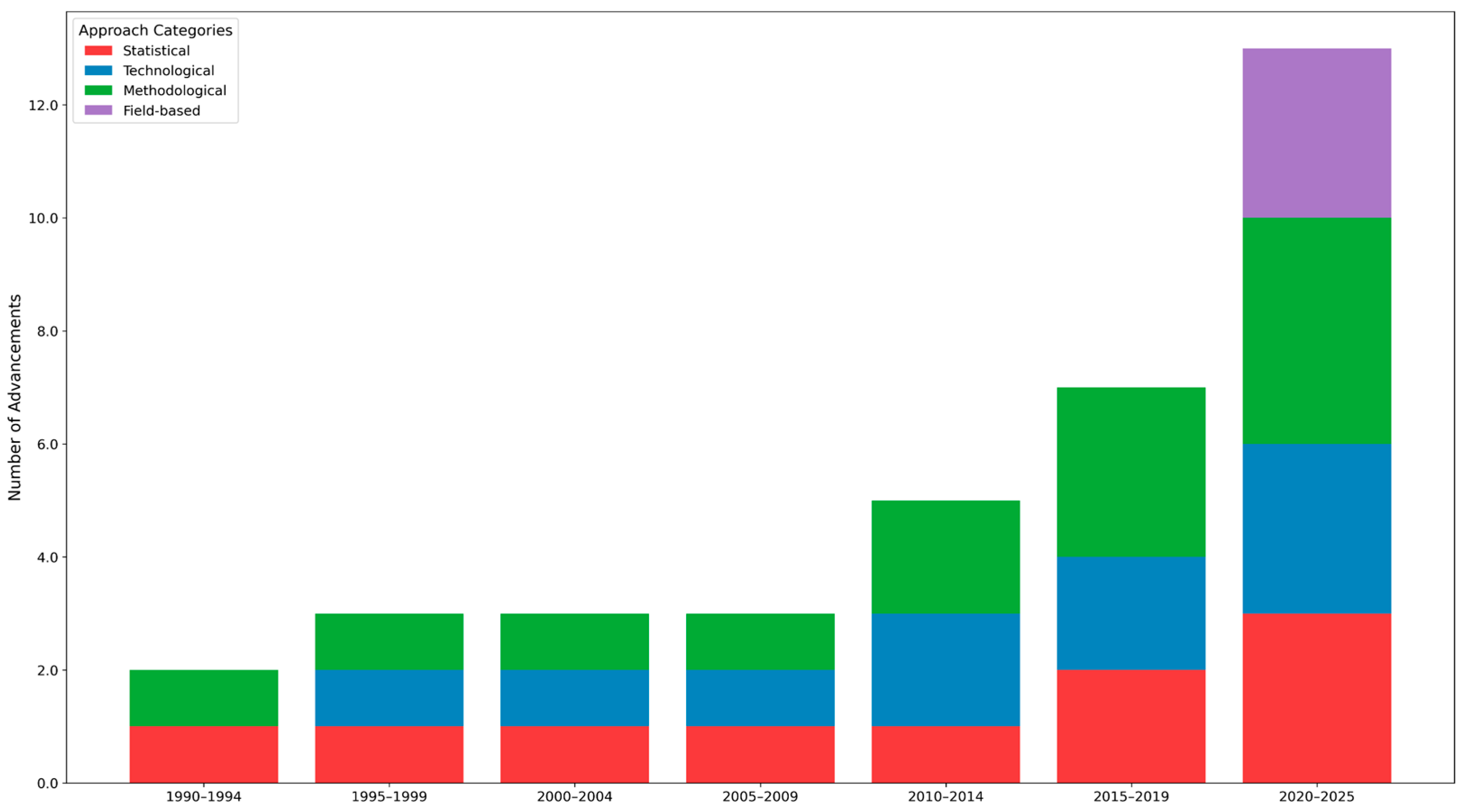
In the assessment of post-tropical cyclone impacts, in situ fieldwork and ground surveys have served as crucial validation mechanisms for remotely sensed data, offering direct empirical evidence that complements satellite-derived observations [66,77,82,83]. Figure 7 summarizes the chronological evolution of statistical, technological, methodological and field-based approaches employed in the reviewed studies between 1990 and 2025.
While some studies acknowledge the challenges of collecting contemporaneous field data, particularly for past events [83], the consensus emphasizes its invaluable nature, especially for understanding nuanced impacts like ESSP and social responses, which are often unobtainable from secondary sources alone [83]. Field surveys have been the primary method for data collection in a significant portion of existing literature, especially for assessing vegetation damage, water and sanitation problems, income losses, and infrastructural damages [66]. Researchers explicitly state that while satellite imagery is highly useful, it cannot fully replace ground observations for comprehensive assessment of cyclone damages and recovery in tropical forests [66,82]. Qualitative validation often involves the use of field photographs to confirm severe damages detected from satellite imagery, such as defoliation, broken branches, and uprooting of mangroves [72]. Furthermore, interviews and focus group discussions (FGDs) with local communities provide crucial retrospective information on degradation causes and validate human perceptions of ecosystem services, contributing essential socio-economic dimensions to the impact assessment [19,83,96]. Despite their importance, field-based methods can face limitations due to accessibility issues and potential spatial bias, particularly when assessing large-scale cyclone impacts [51].

3.4.2. UAV and Drone-Based Validation

UAVs, commonly known as drones, have emerged as a significant tool for capturing high-resolution imagery to validate satellite-based damage assessments in coastal and mangrove ecosystems [49]. These platforms are capable of collecting centimeter-scale imagery and diverse data types, including LiDAR, multi and hyperspectral spatial scales [49]. The spatial benefits of UAVs include improved accuracy in mangrove forest classification and the estimation of tree-level growth characteristics, enabling the detection of ecological changes [49]. This high-resolution data directly enhances the reliability of larger-scale satellite observations [49]. However, operational challenges remain, such as susceptibility to adverse weather conditions, need for trained personnel, specialized equipment, and logistical or regulatory hurdles in certain regions [49,52]. Despite these challenges, UAVs offer advantages in terms of reduced costs and human risks compared to extensive field surveys [49].

3.4.3. Community-Based and Participatory Data

The integration of local knowledge and community-driven data collection methods has proven highly valuable in validating cyclone impact assessments, particularly in understanding the socio-economic dimensions and human–ecosystem interactions [83]. FGDs are a prominent example, serving as an efficient and cost-effective method to gather in-depth human perceptions of ecosystem services. These discussions allow for the collection of comprehensive information and provide opportunities for clarification, ensuring that local inhabitants knowledge about ecosystem services is accurately captured and consistent with resulting impact maps [83]. Participatory methods extend beyond mere data collection, fostering stronger relationships between local communities and institutions, which can enhance collective action for disaster response and recovery [97]. Studies have actively engaged residents in areas prone to climate hazards to establish an evidence base of loss and damage, highlighting the importance of local perspectives on livelihood vulnerability, preventive measures, and coping strategies [96,97]. This community involvement not only enriches the analytical framework but also contributes to developing more relevant and effective adaptation policies and ecosystem restoration efforts tailored to site-specific needs and pressures [25,97].

3.4.4. Accuracy Assessment Approaches

To ensure the reliability and suitability of remote sensing outputs in cyclone impact validation studies, various statistical methods are commonly employed. The error matrix, also known as the confusion matrix, is a standard approach used to evaluate classification accuracy [21,23,83]. From this matrix, key accuracy measures are derived, including Overall Accuracy (OA), Producer’s Accuracy (PA), and User’s Accuracy (UA) [21,22,23]. The Kappa coefficient (κ) is frequently calculated alongside these metrics to assess the agreement between classified results and reference data [21,22,23,76,83,90]. Beyond classification, regression-based assessments often utilize metrics such as the Root Mean Squared Error (RMSE) and Mean Absolute Error (MAE) to quantify the differences between predicted and observed values [22,72]. For evaluating the performance of machine learning models in predicting damage, Receiver Operating Characteristic (ROC) curves and the Area Under the Curve (AUC) are also computed, providing insights into the model’s ability to distinguish between damaged and non-damaged areas [22,69].

3.5. Economic Valuation of Mangrove Ecosystem Services After Cyclones on Previous Work

Previous studies have employed diverse methodologies to assess the economic value of mangrove ecosystem services in the aftermath of tropical cyclones, often emphasizing the financial implications of damage and the benefits of their protective functions. Table 3 outlines key ecosystem service assessment methods, their application contexts, and respective strengths and limitations.
Methodologies for economic valuation frequently include calculating replacement costs for ecosystem rehabilitation or replanting efforts, particularly for damaged green infrastructure elements like mangroves [99]. However, quantifying the intrinsic value of lost green infrastructure and its services remains challenging due to the absence of appropriate pricing methods for non-marketed goods and services [83,98,99]. Contingent valuation (e.g., willingness-to-pay assessments) has been used to estimate the value of ecosystem restoration [83,98], while benefit transfer and meta-analysis approaches have been utilized to synthesize existing economic values and apply them across different regions [26,49,100]. Some studies have also adopted spatially explicit Ecosystem Service Value (ESV) calculations, integrating time-series satellite data with unit values [26]. Also, numerical modeling, such as the CLIMate ADAptation (CLIMADA) risk platform, has been increasingly applied to quantify the protection provided by coastal ecosystems, modeling the number of beneficiaries and assets protected from tropical cyclones [4,30].
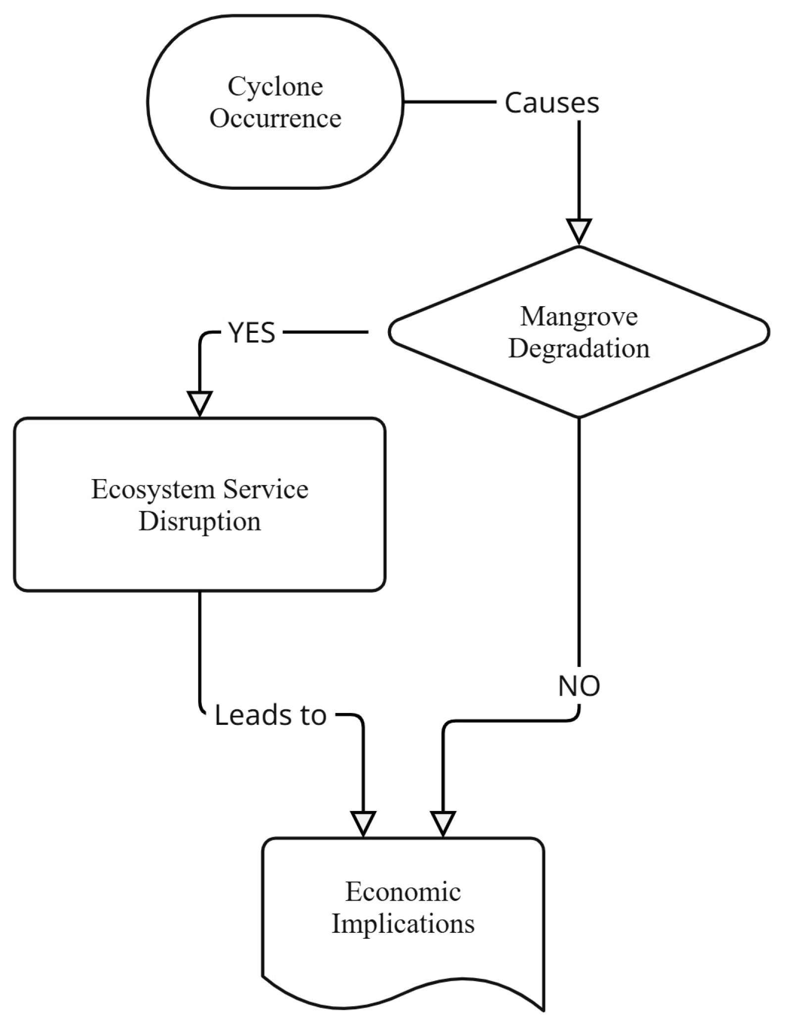
Post-cyclone ecosystem services, particularly coastal protection and disaster risk reduction, are highly valued and extensively researched, demonstrating their significance in economic impact assessment [100]. Regional case studies provide tangible examples of quantified economic losses and protective values. In Bangladesh, analyses after Cyclone Bulbul showed significant changes in land features, including increased water bodies and decreased agricultural and dense vegetation areas, leading to considerable socioeconomic losses [76]. The Sundarbans mangrove ecosystem in Bangladesh and India has seen its total ecosystem service value estimated in the tens of billions of US dollars annually, with mangroves being the primary contributor [26]. In the Philippines, mangroves are estimated to prevent $1 billion in annual property losses from floods [87]. A study in Oman, following Tropical Cyclone Gonu, demonstrated that mangroves could reduce flow velocity by up to 49% and inundation depth by 17.9%, underscoring their protective value [87]. Similarly, Vietnam has realized significant economic benefits from mangroves in reducing dike repair costs and avoiding losses to public infrastructure [20]. Figure 8 outlines the pathway of ecosystem service disruption following cyclone events, linking mangrove degradation and economic implications.
Geospatial analysis plays a crucial role in linking biophysical changes to economic implications [19,22,50,66,76,83]. Vegetation indices (e.g., NDVI, EVI) derived from satellite imagery are used to quantify vegetation health and vigor, which can be directly linked to the provision and economic value of ecosystem services [50,51,73,77]. SAR data, for example, is critical for estimating biomass and structural changes, which directly inform carbon stock valuations [50]. The integration of these geospatial techniques enables detailed, large-scale assessments of damage and recovery trajectories, providing essential information for coastal management, disaster preparedness, and the formulation of resilient development policies [50,51,76,77,78,81].

3.6. Gaps and Challenges in the Current Literature

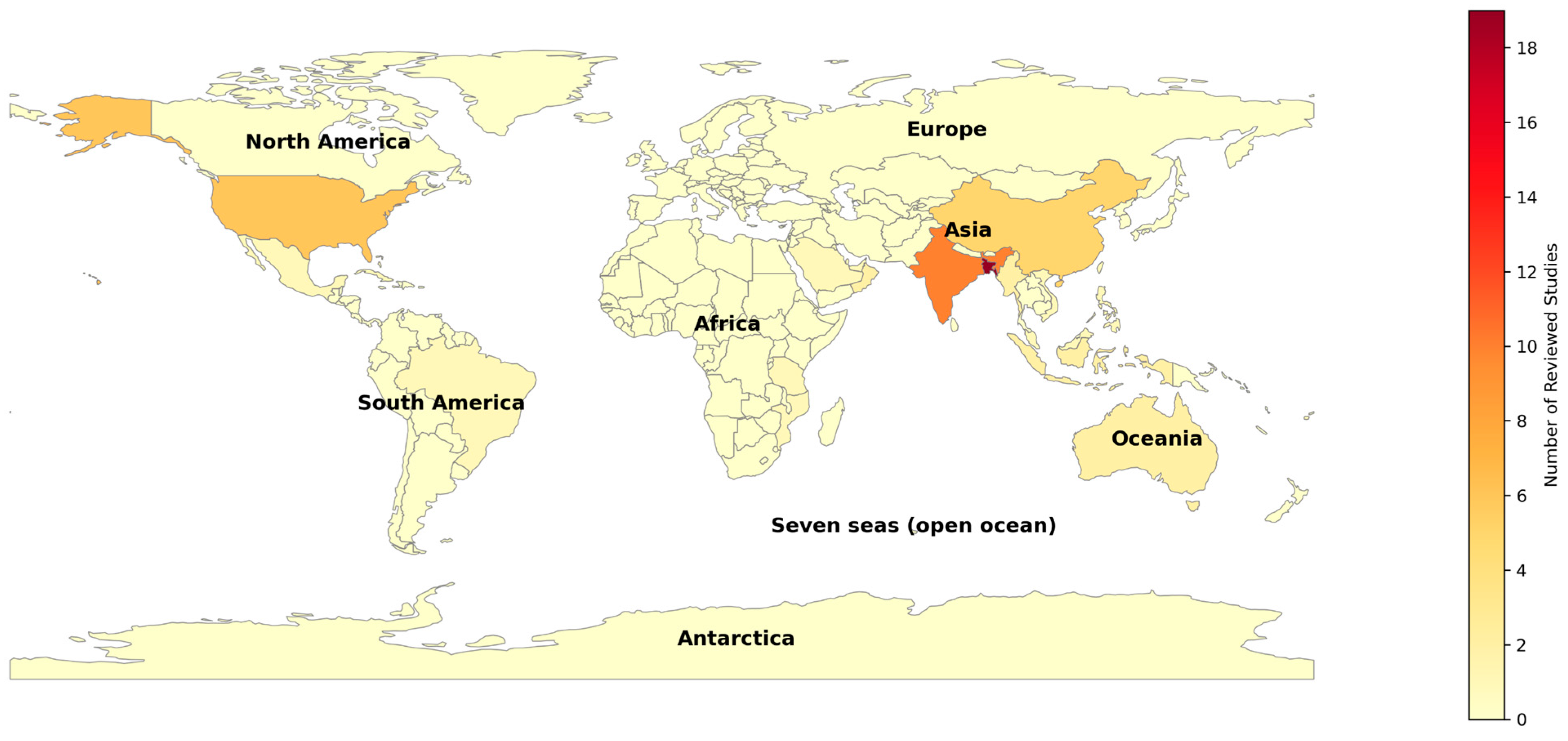
Past studies on post-tropical cyclone impact assessment in coastal and mangrove ecosystems, while advancing remote sensing applications, reveal several critical limitations and research gaps that hinder comprehensive understanding and effective management. A prominent geographic bias exists, with the majority of research concentrated in Asia (e.g., Bangladesh and India) and North/Central America, while vulnerable regions like Africa (e.g., Madagascar, Mozambique, Mauritius) and many Small Island Developing States remain significantly underrepresented [19,24,56,66].
Figure 9 illustrates the global geographic distribution of the 74 reviewed studies, highlighting regional concentrations of cyclone-prone areas. Of the 65 country-level study instances identified across the reviewed literature, Asia accounts for the overwhelming majority at approximately 75.4%, with Bangladesh alone representing 29.2% and Bangladesh and India combined accounting for 44.6% of all reviewed studies. The Americas, primarily the United States, Brazil, and Mexico, contribute 16.9% of the total, while Africa accounts for only 3.1%, Australia for 3.1%, and the Pacific Islands for 1.5%. This means that Asia and the Americas together account for 92.3% of the reviewed literature, leaving cyclone-prone regions including Mozambique, Tanzania, Fiji, and Small Island Developing States across the Indian and Pacific Oceans with negligible representation in the current body of knowledge.
Methodologically, there is a persistent underutilization of high-resolution satellite imagery (e.g., 1–5 m) and SAR data, despite their proven advantages in penetrating cloud cover and providing detailed post-disaster assessments [29,50,56,70,83,89,90]. This is often attributed to cost constraints, limited availability, and challenges in processing large datasets, forcing reliance on lower-resolution optical data prone to cloud obstruction and seasonal variations [19,29,69,78,83]. Furthermore, the literature is characterized by a lack of standardized classification systems and methodologies for quantifying cyclone-induced damage and recovery in mangroves and coastal areas, leading to inconsistent results and impeding cross-study comparisons [49,51,73,75,89]. This inconsistency extends to the limited assessment of functional changes within ecosystems, often prioritizing areal loss over the complex interplay of ecological indicators [70,80,83]. Table 4 summarizes the core limitations identified across the reviewed studies, categorized by data, methodological, and scale-related challenges, along with proposed strategies to address each.
Critically, there remains a weak integration of remote sensing data with broader socio-economic and policy dimensions, as studies frequently fail to translate biophysical impacts into economic valuations for non-marketed ecosystem services or to incorporate adaptation strategies and local community perspectives [32,66,76,77,78,79,83,101]. Lastly, assessments in inaccessible or remote areas are especially afflicted by a widespread lack of reliable ground-truthing and post-event field validation, which compromises the precision and dependability of damage estimates derived from satellites [21,22,50,52,56,63,69,77,83]. These systemic gaps collectively limit the practical application of scientific findings for resilient coastal planning and policy formulation.

3.7. Toward an Integrated Framework for Resilience

A comprehensive and multifaceted integration of remote sensing data, rigorous field-based validation, and essential local and community knowledge is required for an efficient framework for evaluating and improving resilience in coastal and mangrove ecosystems after a tropical cyclone. While remote sensing offers an unparalleled synoptic view for detecting and quantifying ecosystem changes at various spatio-temporal scales [19,50], its accuracy and reliability are significantly enhanced by ground-truthing and post-event validation, particularly in inaccessible areas where direct observation is challenging but crucial [49,51,52,66,73,77]. Complementing this, the perceptions of local inhabitants are indispensable, providing unique insights and potential impacts that cannot be obtained from secondary sources alone [24,83]. This integrated approach is pivotal for developing context-sensitive resilience frameworks that accurately reflect the complex interplay between biophysical changes, functional changes, and human dimensions [50,80,83].
Remote sensing technologies are instrumental in enhancing early warning systems and enabling rapid post-cyclone impact assessments, which are critical for timely rescue, rehabilitation, and resource allocation by decision-makers and emergency response teams [29,74,89,102]. Such rapid assessments, coupled with geospatial analysis, allow for the quick identification of damage hotspots, guiding initial response efforts and informing the efficacy of restoration and relief work [29,52,68,93].
Beyond immediate response, the integrated geospatial frameworks are vital for informing policy development, strategic coastal zone management, and long-term post-disaster recovery planning. By mapping flood-prone areas, quantifying vegetation loss, and assessing LULC changes, policymakers gain crucial information to identify priority intervention zones and formulate adaptive strategies [21,70,83]. For instance, comprehensive damage assessments can guide the reinforcement of infrastructure like dams and promote the introduction of salt-tolerant plant species to enhance community resilience, as observed in studies for the Sundarbans region [21,70]. The effectiveness of such tools, however, relies on the quality and geometric accuracy of data, alongside technical expertise, to provide a sound scientific basis for integrated management policy formulations [50].
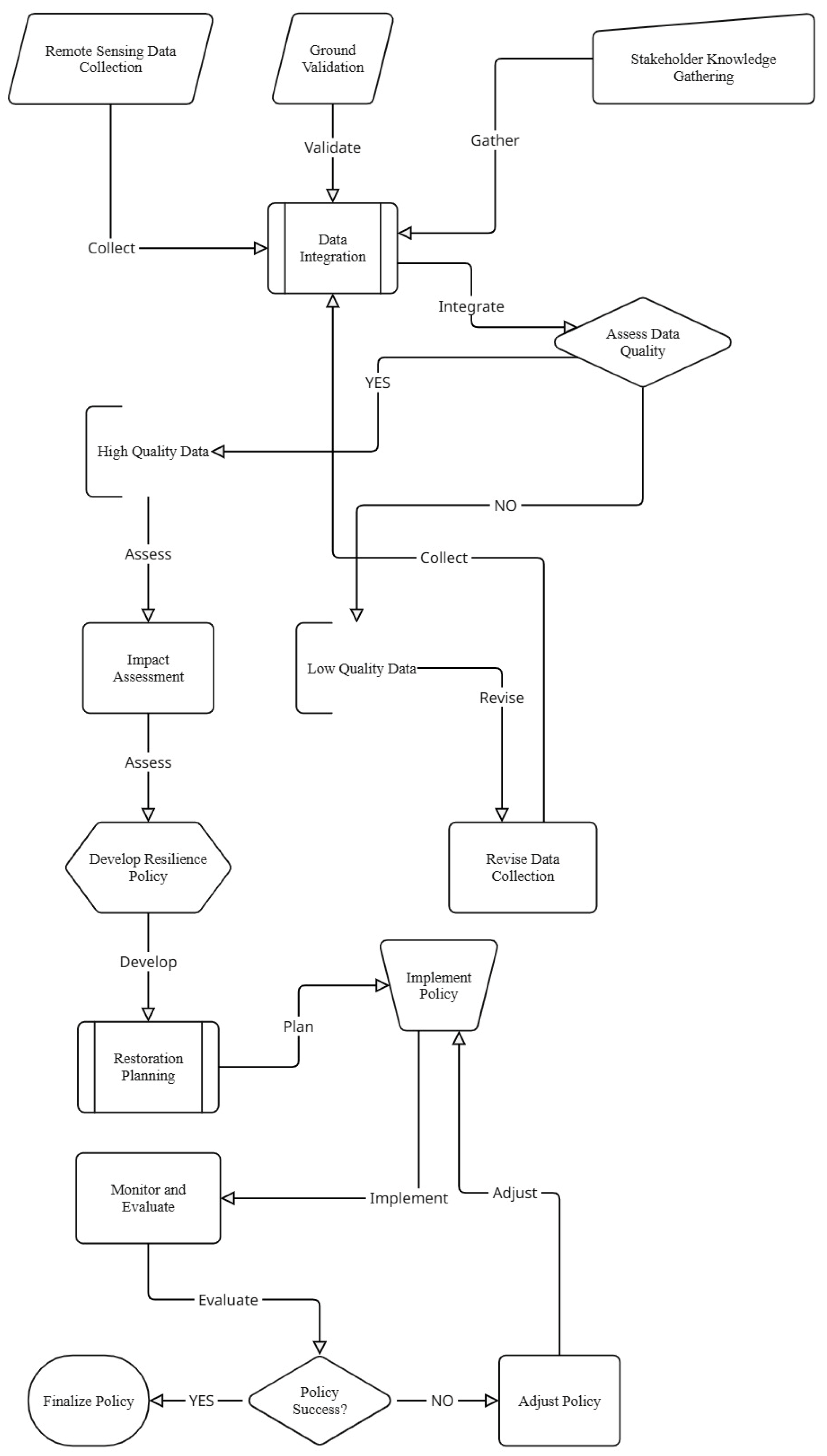
Looking forward, future research must address existing gaps and leverage emerging technological advancements. Figure 10 presents a framework for integrated cyclone impact assessment and resilience planning using multi-sensor remote sensing, combining the knowledge from the reviewed literature. This includes the increased utilization of high-resolution satellite imagery (e.g., 1–5 m) and UAV data, which, despite cost and processing challenges, offer greater precision in damage demarcation and ecosystem mapping than moderate-resolution data often used [29,49,66,83]. There is a pressing need for further development and adoption of artificial intelligence (AI), machine learning (ML), and deep learning (DL) algorithms to enhance post-cyclone impact analysis, prediction, and the identification of functional changes within ecosystems [49,52,70]. Establishing long-term monitoring platforms with wider temporal scales is essential for understanding recovery trajectories and recurrent disturbance impacts, moving beyond immediate aftermath assessments [66,67,70,83]. In order to quantify cyclone-induced damage and recovery across various regions and case studies, the field needs standardized classification systems and methodologies. This will enable strong cross-comparisons and more accurate economic valuations of ecosystem services. Lastly, interdisciplinary cooperation that incorporates ecological, social, economic, and policy aspects will guarantee that resilience frameworks are genuinely comprehensive and relevant to the actual difficulties that vulnerable coastal communities face [16,19,101].

4. Discussion

Remote sensing has emerged as an indispensable tool for understanding tropical cyclone impacts on coastal and mangrove ecosystems, primarily by enabling synoptic and multi-temporal assessments of land cover and vegetation changes [19,21,29,48,51,56,67,68,83]. Studies consistently demonstrate its utility in quantifying immediate damage, such as vegetation defoliation, uprooting, and changes in LULC, as well as monitoring subsequent recovery trajectories [66,73,76,77,80,81,83,85,89,91]. Various remote sensing techniques have been employed, including the widespread use of optical imagery (e.g., Landsat, Sentinel-2) and a growing reliance on SAR data, especially Sentinel-1, for its all-weather, day-night capabilities that overcome cloud cover limitations often experienced during and immediately after cyclone events [19,23,29,50,56,63,68,70,80,83,90,92]. Vegetation indices (NDVI, EVI, LAI) and specialized damage indices (mVCI, DVDI) are frequently utilized to quantify changes in vegetation vigor and health [29,50,69,73,77,80,81,85,91]. Methodological patterns reveal a common reliance on change detection analyses (pre- and post-cyclone image comparisons) [56,69,73,76,83], often integrating GIS for spatial analysis and mapping [19,76,77,78,80,81]. Despite these advancements, a significant geographic bias persists, with research heavily concentrated in Asia (particularly Bangladesh and India) and North/Central America, while highly vulnerable regions like Africa and Pacific Island nations remain largely underrepresented.
Current remote sensing approaches offer substantial strengths for post-cyclone impact assessment, including global coverage and temporal consistency [19,21,48,51,56,67,68], enabling rapid post-event assessments crucial for emergency response and decision-making [29,52,55,56,92]. The increasing availability of freely accessible data (e.g., Sentinel, Landsat) and cloud-computing platforms like GEE has significantly democratized and expedited analyses, reducing computational burdens [29,30,51,63,69,70,71,72,80,92,93,94]. Machine learning algorithms (Random Forest, SVM, etc.) are also demonstrating enhanced accuracy in damage detection and risk modeling compared to traditional methods [49,53,55,69,72,76,91].
However, significant limitations also persist. Optical imagery is severely hampered by cloud cover, a common occurrence during and after cyclones, necessitating the use of SAR, which itself has limitations in distinguishing between water and water-like surfaces or under-canopy flooding [23,29,50,53,56,63,68,70,72,83,90,91,92]. On the other hand, the spatial resolution of freely available data (e.g., 10–30 m) can be insufficient for detecting fine-scale damage, distinguishing mixed pixels, or mapping individual tree-level characteristics, which are often overlooked [20,49,53,56,66,69,72,77,83,94]. While high-resolution UAV and LiDAR data offer greater precision, their cost and limited spatial/temporal coverage restrict widespread application [49,51,53,66]. Furthermore, many studies lack robust ground-truthing and post-event field validation, particularly in remote or inaccessible areas, which undermines the accuracy and reliability of remote sensing-derived findings [29,49,50,52,56,63,66,70,73,79,83,89].
The poor integration of remote sensing data with socioeconomic and policy aspects is another significant obstacle. Studies frequently focus on biophysical impacts, neglecting the translation of these findings into tangible implications for human livelihoods, community resilience, or economic valuation of non-marketed ecosystem services. A communication gap between the scientific community and local stakeholders/policymakers and a lack of standardized methodologies for evaluating performance are two common causes of the observed discrepancy between scientific findings and actual policy implementation [79,86]. Achieving holistic, context-sensitive resilience frameworks requires integrating remote sensing data not only with ground-based validation but also with local and community knowledge and perceptions [19,32,79,83,86,88,100].
The economic assessment of ecosystem losses in the reviewed literature remains underdeveloped and inconsistent, particularly beyond easily quantifiable provisioning services like crops and timber [83,99]. While studies acknowledge the importance of ecosystem services in supporting livelihoods and disaster risk reduction [19,20,28,30,49,83,99,100], the quantification and measurement of non-marketed ecosystem goods and services (such as regulating, cultural, habitat services) pose significant challenges [19,83,99]. This valuations, often refer to costs of replanting or rehabilitation measures rather than the true economic value of lost green infrastructure and the services they provide [19,99]. The oversight of disaster-related losses leads to undervaluing ecosystem contributions to resilience, hindering comprehensive cost–benefit analyses for nature-based solutions and potentially resulting in suboptimal policy decisions [79,99,101].
To advance the field, future research must prioritize several key areas. The adoption of emerging technologies, particularly AI, ML, and DL algorithms, holds immense promise for enhancing post-cyclone impact analysis, prediction, and the identification of subtle functional changes within ecosystems. These methods can improve the accuracy of damage assessments, overcome data complexity, and facilitate near-real-time processing [29,55,69,70,71,92,93]. There is also a pressing need for increased utilization of high-resolution satellite imagery (e.g., 1–5 m) and UAV data, coupled with LiDAR, to provide more granular insights into damage demarcation, forest structural changes, and individual tree-level characteristics, which are currently underutilized due to cost and processing challenges [29,49,50,53,56,63,66,69,70,72,77,83,90].
Establishing long-term monitoring platforms with wider temporal scales is also essential for understanding recovery trajectories, recurrent disturbance impacts, and the long-term effects of climate change, moving beyond immediate aftermath assessments [19,25,28,49,63,66,70,73,79,83]. This should also involve integrating climate models to project future impacts and responses of coastal features under changing climate conditions [27,30,44,73]. Furthermore, research should prioritize standardizing impact metrics and damage classification systems across regions and case studies to enable robust cross-comparisons and more reliable economic valuations of ecosystem services. Finally, fostering interdisciplinary collaboration involving ecological, social, economic, and policy dimensions is crucial for developing holistic resilience frameworks for vulnerable coastal communities worldwide.

5. Conclusions

This review synthesizes three decades of advancements in remote sensing technologies for assessing post-tropical cyclone impacts on coastal and mangrove ecosystems. The findings highlight the transformative potential of multi-sensor approaches particularly the integration of optical, SAR, and LiDAR data for detecting physical, biological, and ecological damages with increased precision and timeliness. These technologies have been instrumental in mapping inundation, vegetation degradation, and ecosystem service disruptions while enhancing the understanding of resilience and recovery dynamics. Notably, the review underscores remote sensing’s vital role in strengthening climate resilience by enabling rapid, scalable, and non-intrusive assessments of cyclone-induced disturbances, especially in data-scarce regions. However, it also reveals persistent gaps in validation practices, geographic representation, and the integration of socio-economic dimensions. The review advocates for a paradigm shift toward more integrated frameworks that combine multi-sensor data, field validation, community knowledge, and policy application. Such participatory and technologically inclusive approaches are essential for advancing sustainable mangrove management and supporting long-term adaptation in cyclone-prone coastal and mangrove areas. By consolidating current knowledge and identifying emerging opportunities, this review provides a critical foundation for future research, operational tools, and resilience-oriented decision-making systems in the face of escalating climate hazards.

Author Contributions

Conceptualization, S.S. and I.J.; methodology, S.S.; software, S.S.; validation, S.S., I.J. and T.A.; formal analysis, S.S.; investigation, T.A. and S.S.; resources, S.S. and X.W.; data curation, S.S.; writing—original draft preparation, S.S. and T.A.; writing—review and editing, S.S., I.J., T.A., A.A. and X.W.; visualization, S.S.; supervision, X.W.; project administration, S.S. All authors have read and agreed to the published version of the manuscript.

Funding

This research received no external funding.

Data Availability Statement

No new data were created or analyzed in this study. Data sharing is not applicable to this article.

Acknowledgments

The authors would like to acknowledge the support received during the preparation of this manuscript.

Conflicts of Interest

The authors declare no conflicts of interest.

Abbreviations

The following abbreviations are used in this manuscript:
AIArtificial Intelligence
AR6Sixth Assessment Report
AUCArea Under the Curve
DLDeep Learning
DPSIRDriver, Pressure, State, Impact, and Response
ESSPEcosystem Service Supply Proficiency
ESVEcosystem Service Value
FGDFocus Group Discussion
GEEGoogle Earth Engine
IPCCIntergovernmental Panel on Climate Change
LiDARLight Detection and Ranging
LULCLand Use and Land Cover
MAEMean Absolute Error
MLMachine Learning
OAOverall Accuracy
PAProducer’s Accuracy
PRISMAPreferred Reporting Items for Systematic Reviews and Meta Analyses
RMSERoot Mean Squared Error
ROCReceiver Operating Characteristic
SARSynthetic Aperture Radar
SLRSystematic Literature Review
UAUser’s Accuracy
UAVUnmanned Aerial Vehicle

References

  1. Rivonker, C.U.; Padate, V.P.; Hegde, M.R.; Velip, D.T. Habitat Complexity of Tropical Coastal Ecosystems: An Ecosystem Management Perspective. In Environmental Management of Marine Ecosystems; CRC Press: Boca Raton, FL, USA, 2018; ISBN 978-1-315-15393-3. [Google Scholar]
  2. Barbier, E.B.; Hacker, S.D.; Kennedy, C.; Koch, E.W.; Stier, A.C.; Silliman, B.R. The Value of Estuarine and Coastal Ecosystem Services. Ecol. Monogr. 2011, 81, 169–193. [Google Scholar] [CrossRef] [Scilit]
  3. Blythe, J.; Armitage, D.; Alonso, G.; Campbell, D.; Esteves Dias, A.C.; Epstein, G.; Marschke, M.; Nayak, P. Frontiers in Coastal Well-Being and Ecosystem Services Research: A Systematic Review. Ocean Coast. Manag. 2020, 185, 105028. [Google Scholar] [CrossRef] [Scilit]
  4. Hülsen, S.; McDonald, R.I.; Chaplin-Kramer, R.; Bresch, D.N.; Sharp, R.; Worthington, T.; Kropf, C.M. Global Protection from Tropical Cyclones by Coastal Ecosystems—Past, Present, and under Climate Change. Environ. Res. Lett. 2023, 18, 124023. [Google Scholar] [CrossRef] [Scilit]
  5. Murakami, H. Tropical Cyclones in Changing Climate. In Handbook of Air Quality and Climate Change; Akimoto, H., Tanimoto, H., Eds.; Springer Nature: Singapore, 2023; pp. 1093–1138. ISBN 978-981-15-2759-3. [Google Scholar]
  6. Grinsted, A.; Ditlevsen, P.; Christensen, J.H. Normalized US Hurricane Damage Estimates Using Area of Total Destruction, 1900−2018. Proc. Natl. Acad. Sci. USA 2019, 116, 23942–23946. [Google Scholar] [CrossRef] [Scilit]
  7. Arkema, K.K.; Guannel, G.; Verutes, G.; Wood, S.A.; Guerry, A.; Ruckelshaus, M.; Kareiva, P.; Lacayo, M.; Silver, J.M. Coastal Habitats Shield People and Property from Sea-Level Rise and Storms. Nat. Clim. Change 2013, 3, 913–918. [Google Scholar] [CrossRef] [Scilit]
  8. Beck, M.W.; Losada, I.J.; Menéndez, P.; Reguero, B.G.; Díaz-Simal, P.; Fernández, F. The Global Flood Protection Savings Provided by Coral Reefs. Nat. Commun. 2018, 9, 2186. [Google Scholar] [CrossRef] [Scilit] [PubMed]
  9. Chaplin-Kramer, R.; Sharp, R.P.; Weil, C.; Bennett, E.M.; Pascual, U.; Arkema, K.K.; Brauman, K.A.; Bryant, B.P.; Guerry, A.D.; Haddad, N.M.; et al. Global Modeling of Nature’s Contributions to People. Science 2019, 366, 255–258. [Google Scholar] [CrossRef] [Scilit]
  10. Chaplin-Kramer, R.; Neugarten, R.A.; Sharp, R.P.; Collins, P.M.; Polasky, S.; Hole, D.; Schuster, R.; Strimas-Mackey, M.; Mulligan, M.; Brandon, C.; et al. Mapping the Planet’s Critical Natural Assets. Nat. Ecol. Evol. 2022, 7, 51–61. [Google Scholar] [CrossRef] [Scilit]
  11. Costanza, R.; Anderson, S.J.; Sutton, P.; Mulder, K.; Mulder, O.; Kubiszewski, I.; Wang, X.; Liu, X.; Pérez-Maqueo, O.; Luisa Martinez, M.; et al. The Global Value of Coastal Wetlands for Storm Protection. Glob. Environ. Change 2021, 70, 102328. [Google Scholar] [CrossRef] [Scilit]
  12. Menéndez, P.; Losada, I.J.; Torres-Ortega, S.; Narayan, S.; Beck, M.W. The Global Flood Protection Benefits of Mangroves. Sci. Rep. 2020, 10, 4404. [Google Scholar] [CrossRef] [Scilit] [PubMed]
  13. Reguero, B.G.; Secaira, F.; Toimil, A.; Escudero, M.; Díaz-Simal, P.; Beck, M.W.; Silva, R.; Storlazzi, C.; Losada, I.J. The Risk Reduction Benefits of the Mesoamerican Reef in Mexico. Front. Earth Sci. 2019, 7, 125. [Google Scholar] [CrossRef] [Scilit]
  14. Reguero, B.G.; Storlazzi, C.D.; Gibbs, A.E.; Shope, J.B.; Cole, A.D.; Cumming, K.A.; Beck, M.W. The Value of US Coral Reefs for Flood Risk Reduction. Nat. Sustain. 2021, 4, 688–698. [Google Scholar] [CrossRef] [Scilit]
  15. Selig, E.R.; Hole, D.G.; Allison, E.H.; Arkema, K.K.; McKinnon, M.C.; Chu, J.; De Sherbinin, A.; Fisher, B.; Glew, L.; Holland, M.B.; et al. Mapping Global Human Dependence on Marine Ecosystems. Conserv. Lett. 2019, 12, e12617. [Google Scholar] [CrossRef] [Scilit]
  16. Spalding, M.D.; McIvor, A.L.; Beck, M.W.; Koch, E.W.; Möller, I.; Reed, D.J.; Rubinoff, P.; Spencer, T.; Tolhurst, T.J.; Wamsley, T.V.; et al. Coastal Ecosystems: A Critical Element of Risk Reduction. Conserv. Lett. 2014, 7, 293–301. [Google Scholar] [CrossRef] [Scilit]
  17. Tiggeloven, T.; De Moel, H.; Van Zelst, V.T.M.; Van Wesenbeeck, B.K.; Winsemius, H.C.; Eilander, D.; Ward, P.J. The Benefits of Coastal Adaptation through Conservation of Foreshore Vegetation. J. Flood Risk Manag. 2022, 15, e12790. [Google Scholar] [CrossRef] [Scilit]
  18. Khan, M.S.; Akter, A.; Khan, I.; Aguila, L.C.R.; Akter, L.; Yang, M.; Li, X.; Li, Y. Assessing Long Term Impact of Regional Climate and Human Activities on Vegetation Greenness Dynamics in Sundarbans. Ecol. Inform. 2025, 85, 102984. [Google Scholar] [CrossRef] [Scilit]
  19. Dahdouh-Guebas, F. The Use of Remote Sensing and GIS in the Sustainable Management of Tropical Coastal Ecosystems. Environ. Dev. Sustain. 2002, 4, 93–112. [Google Scholar] [CrossRef] [Scilit]
  20. McIvor, A.; Spencer, T.; Spalding, M.; Lacambra, C.; Möller, I. Mangroves, Tropical Cyclones, and Coastal Hazard Risk Reduction. In Coastal and Marine Hazards, Risks, and Disasters; Elsevier: Amsterdam, The Netherlands, 2015; pp. 403–429. ISBN 978-0-12-396483-0. [Google Scholar]
  21. Roy, S.K.; Mojumder, P.; Chowdhury, M.A.A.; Hasan, M.M. Evaluating Mangrove Forest Dynamics and Fragmentation in Sundarbans, Bangladesh Using High-Resolution Sentinel-2 Satellite Images. Glob. Ecol. Conserv. 2025, 58, e03493. [Google Scholar] [CrossRef] [Scilit]
  22. Saoum, M.R.; Sarkar, S.K. Monitoring Mangrove Forest Change and Its Impacts on the Environment. Ecol. Indic. 2024, 159, 111666. [Google Scholar] [CrossRef] [Scilit]
  23. Huang, K.; Yang, G.; Yuan, Y.; Sun, W.; Meng, X.; Ge, Y. Optical and SAR Images Combined Mangrove Index Based on Multi-Feature Fusion. Sci. Remote Sens. 2022, 5, 100040. [Google Scholar] [CrossRef] [Scilit]
  24. Sunkur, R.; Kantamaneni, K.; Bokhoree, C.; Ravan, S. Mangroves’ Role in Supporting Ecosystem-Based Techniques to Reduce Disaster Risk and Adapt to Climate Change: A Review. J. Sea Res. 2023, 196, 102449. [Google Scholar] [CrossRef] [Scilit]
  25. Amaral, C.; Poulter, B.; Lagomasino, D.; Fatoyinbo, T.; Taillie, P.; Lizcano, G.; Canty, S.; Silveira, J.A.H.; Teutli-Hernández, C.; Cifuentes-Jara, M.; et al. Drivers of Mangrove Vulnerability and Resilience to Tropical Cyclones in the North Atlantic Basin. Sci. Total Environ. 2023, 898, 165413. [Google Scholar] [CrossRef] [Scilit] [PubMed]
  26. Sannigrahi, S.; Chakraborti, S.; Banerjee, A.; Rahmat, S.; Bhatt, S.; Jha, S.; Singh, L.K.; Paul, S.K.; Sen, S. Ecosystem Service Valuation of a Natural Reserve Region for Sustainable Management of Natural Resources. Environ. Sustain. Indic. 2020, 5, 100014. [Google Scholar] [CrossRef] [Scilit]
  27. Hülsen, S.; Dee, L.E.; Kropf, C.M.; Meiler, S.; Bresch, D.N. Mangroves and Their Services Are at Risk from Tropical Cyclones and Sea Level Rise under Climate Change. Commun. Earth Environ. 2025, 6, 262. [Google Scholar] [CrossRef] [Scilit]
  28. Krauss, K.W.; Osland, M.J. Tropical Cyclones and the Organization of Mangrove Forests: A Review. Ann. Bot. 2019, mcz161. [Google Scholar] [CrossRef] [Scilit] [PubMed]
  29. Mondal, P.; Dutta, T.; Qadir, A.; Sharma, S. Radar and Optical Remote Sensing for near Real-time Assessments of Cyclone Impacts on Coastal Ecosystems. Remote Sens. Ecol. Conserv. 2022, 8, 506–520. [Google Scholar] [CrossRef] [Scilit]
  30. Kropf, C.M.; Vaterlaus, L.; Bresch, D.N.; Pellissier, L. Tropical Cyclone Risk for Global Ecosystems in a Changing Climate. Nat. Clim. Change 2025, 15, 92–100. [Google Scholar] [CrossRef] [Scilit]
  31. Sarker, M.M.H.; Gain, A.K.; Paul, N.K.; Biswas, S.R. A Trait-Based Approach to Quantify Ecosystem Services Delivery Potentials in the Sundarbans Mangrove Forest of Bangladesh. Ecol. Indic. 2024, 166, 112390. [Google Scholar] [CrossRef] [Scilit]
  32. Rahman, K.-S.; Dana, N.H.; Rahman, M.M.; Mondal, H.S.; Chen, L.; Islam, M.N. Degradation of Mangrove Forests in the Sundarbans: An Assessment Based on Perspectives of Mangrove Resource Collectors Using the DPSIR Framework. Trees For. People 2025, 19, 100769. [Google Scholar] [CrossRef] [Scilit]
  33. Mitra, A. Mangroves: A Shield Against Storms and Wave Actions. In Mangrove Forests in India; Springer International Publishing: Cham, Switzerland, 2020; pp. 33–57. ISBN 978-3-030-20594-2. [Google Scholar]
  34. Cuenca-Ocay, G. Mangrove Ecosystems’ Role in Climate Change Mitigation. Davao Res. J. 2024, 12, 72–75. [Google Scholar] [CrossRef] [Scilit]
  35. Bunting, P.; Rosenqvist, A.; Hilarides, L.; Lucas, R.M.; Thomas, N. Global Mangrove Watch: Updated 2010 Mangrove Forest Extent (v2.5). Remote Sens. 2022, 14, 1034. [Google Scholar] [CrossRef] [Scilit]
  36. Chand, S.S.; Walsh, K.J.E.; Camargo, S.J.; Kossin, J.P.; Tory, K.J.; Wehner, M.F.; Chan, J.C.L.; Klotzbach, P.J.; Dowdy, A.J.; Bell, S.S.; et al. Declining Tropical Cyclone Frequency under Global Warming. Nat. Clim. Change 2022, 12, 655–661. [Google Scholar] [CrossRef] [Scilit]
  37. Knutson, T.; Camargo, S.J.; Chan, J.C.L.; Emanuel, K.; Ho, C.-H.; Kossin, J.; Mohapatra, M.; Satoh, M.; Sugi, M.; Walsh, K.; et al. Tropical Cyclones and Climate Change Assessment: Part I: Detection and Attribution. Bull. Am. Meteorol. Soc. 2019, 100, 1987–2007. [Google Scholar] [CrossRef] [Scilit]
  38. Knutson, T.; Camargo, S.J.; Chan, J.C.L.; Emanuel, K.; Ho, C.-H.; Kossin, J.; Mohapatra, M.; Satoh, M.; Sugi, M.; Walsh, K.; et al. Tropical Cyclones and Climate Change Assessment: Part II: Projected Response to Anthropogenic Warming. Bull. Am. Meteorol. Soc. 2020, 101, E303–E322. [Google Scholar] [CrossRef] [Scilit]
  39. Elsner, J.B.; Kossin, J.P.; Jagger, T.H. The Increasing Intensity of the Strongest Tropical Cyclones. Nature 2008, 455, 92–95. [Google Scholar] [CrossRef] [Scilit] [PubMed]
  40. Kang, N.-Y.; Elsner, J.B. Trade-off between Intensity and Frequency of Global Tropical Cyclones. Nat. Clim. Change 2015, 5, 661–664. [Google Scholar] [CrossRef] [Scilit]
  41. Vecchi, G.A.; Landsea, C.; Zhang, W.; Villarini, G.; Knutson, T. Changes in Atlantic Major Hurricane Frequency since the Late-19th Century. Nat. Commun. 2021, 12, 4054. [Google Scholar] [CrossRef] [Scilit]
  42. Wang, S.; Rashid, T.; Throp, H.; Toumi, R. A Shortening of the Life Cycle of Major Tropical Cyclones. Geophys. Res. Lett. 2020, 47, e2020GL088589. [Google Scholar] [CrossRef] [Scilit]
  43. Wang, S.; Toumi, R. More Tropical Cyclones Are Striking Coasts with Major Intensities at Landfall. Sci. Rep. 2022, 12, 5236. [Google Scholar] [CrossRef] [Scilit]
  44. Knutson, T.R.; McBride, J.L.; Chan, J.; Emanuel, K.; Holland, G.; Landsea, C.; Held, I.; Kossin, J.P.; Srivastava, A.K.; Sugi, M. Tropical Cyclones and Climate Change. Nat. Geosci. 2010, 3, 157–163. [Google Scholar] [CrossRef] [Scilit]
  45. Chavez, S.; Wdowinski, S.; Lagomasino, D.; Castañeda-Moya, E.; Fatoyinbo, T.; Moyer, R.P.; Smoak, J.M. Estimating Structural Damage to Mangrove Forests Using Airborne Lidar Imagery: Case Study of Damage Induced by the 2017 Hurricane Irma to Mangroves in the Florida Everglades, USA. Sensors 2023, 23, 6669. [Google Scholar] [CrossRef] [Scilit]
  46. Xiong, L.; Lagomasino, D.; Charles, S.P.; Castañeda-Moya, E.; Cook, B.D.; Redwine, J.; Fatoyinbo, L. Quantifying Mangrove Canopy Regrowth and Recovery after Hurricane Irma with Large-Scale Repeat Airborne Lidar in the Florida Everglades. Int. J. Appl. Earth Obs. Geoinf. 2022, 114, 103031. [Google Scholar] [CrossRef] [Scilit]
  47. Sitthi, A.; Pimple, U.; Piponiot, C.; Gond, V. Assessing the Effectiveness of Mangrove Rehabilitation Using Above-Ground Biomass and Structural Diversity. Sci. Rep. 2025, 15, 7839. [Google Scholar] [CrossRef] [Scilit] [PubMed]
  48. Klemas, V. Remote Sensing Techniques for Studying Coastal Ecosystems: An Overview. J. Coast. Res. 2010, 27, 2. [Google Scholar] [CrossRef] [Scilit]
  49. Rondon, M.; Ewane, E.B.; Abdullah, M.M.; Watt, M.S.; Blanton, A.; Abulibdeh, A.; Burt, J.A.; Rogers, K.; Ali, T.; Reef, R.; et al. Remote Sensing-Based Assessment of Mangrove Ecosystems in the Gulf Cooperation Council Countries: A Systematic Review. Front. Mar. Sci. 2023, 10, 1241928. [Google Scholar] [CrossRef] [Scilit]
  50. Santos, L.C.M.; Bitencourt, M.D. Remote Sensing in the Study of Brazilian Mangroves: Review, Gaps in the Knowledge, New Perspectives and Contributions for Management. Rev. Gestão Costeira Integr. 2016, 16, 245–261. [Google Scholar] [CrossRef] [Scilit]
  51. Asbridge, E.; Krause, C.; Lucas, R.; Owers, C.J.; Rogers, K.; Lymburner, L.; Mueller, N.; Ai, E.; Wong, S. Characterising the Short- and Long-Term Impacts of Tropical Cyclones on Mangroves Using the Landsat Archive. Camb. Prism. Coast. Futures 2025, 3, e4. [Google Scholar] [CrossRef] [Scilit]
  52. Malmgren-Hansen, D.; Sohnesen, T.; Fisker, P.; Baez, J. Sentinel-1 Change Detection Analysis for Cyclone Damage Assessment in Urban Environments. Remote Sens. 2020, 12, 2409. [Google Scholar] [CrossRef] [Scilit]
  53. Pham, T.; Yokoya, N.; Bui, D.; Yoshino, K.; Friess, D. Remote Sensing Approaches for Monitoring Mangrove Species, Structure, and Biomass: Opportunities and Challenges. Remote Sens. 2019, 11, 230. [Google Scholar] [CrossRef] [Scilit]
  54. Kuenzer, C.; Bluemel, A.; Gebhardt, S.; Quoc, T.V.; Dech, S. Remote Sensing of Mangrove Ecosystems: A Review. Remote Sens. 2011, 3, 878–928. [Google Scholar] [CrossRef] [Scilit]
  55. Velden, C.; Knaff, J.; Herndon, D.; Mouche, A.; Hawkins, J.; Panegrossi, G.; Stoffelen, A.; Courtney, J.; Tsukada, T.; Fontan, A.-C. Recent Innovations in Satellite-Based Applications and Their Impacts on Tropical Cyclone Analyses and Forecasts. J. Eur. Meteorol. Soc. 2025, 2, 100011. [Google Scholar] [CrossRef] [Scilit]
  56. Hoque, M.A.-A.; Phinn, S.; Roelfsema, C. A Systematic Review of Tropical Cyclone Disaster Management Research Using Remote Sensing and Spatial Analysis. Ocean Coast. Manag. 2017, 146, 109–120. [Google Scholar] [CrossRef] [Scilit]
  57. Chen, Q.; Wang, H.; Wang, L.; Tawes, R.; Rollman, D. Predicting Impacts of Tropical Cyclones and Sea-Level Rise on Beach Mouse Habitat. J. Coast. Res. 2014, 68, 12–19. [Google Scholar] [CrossRef] [Scilit]
  58. Cole, L.E.S.; Bhagwat, S.A.; Willis, K.J. Recovery and Resilience of Tropical Forests after Disturbance. Nat. Commun. 2014, 5, 3906. [Google Scholar] [CrossRef] [Scilit]
  59. Hogan, J.A.; Feagin, R.A.; Starr, G.; Ross, M.; Lin, T.-C.; O’connell, C.; Huff, T.P.; Stauffer, B.A.; Robinson, K.L.; Lara, M.C.; et al. A Research Framework to Integrate Cross-Ecosystem Responses to Tropical Cyclones. BioScience 2020, 70, 477–489. [Google Scholar] [CrossRef] [Scilit]
  60. Patrick, C.J.; Kominoski, J.S.; McDowell, W.H.; Branoff, B.; Lagomasino, D.; Leon, M.; Hensel, E.; Hensel, M.J.S.; Strickland, B.A.; Aide, T.M.; et al. A General Pattern of Trade-Offs between Ecosystem Resistance and Resilience to Tropical Cyclones. Sci. Adv. 2022, 8, eabl9155. [Google Scholar] [CrossRef] [Scilit] [PubMed]
  61. Caiza-Morales, L.; Gómez, C.; Torres, R.; Nicolau, A.P.; Olano, J.M. MANGLEE: A Tool for Mapping and Monitoring MANgrove Ecosystem on Google Earth Engine—A Case Study in Ecuador. J. Geovis. Spat. Anal. 2024, 8, 17. [Google Scholar] [CrossRef] [Scilit]
  62. Attari, N.; Ofli, F.; Awad, M.; Lucas, J.; Chawla, S. Nazr-CNN: Fine-Grained Classification of UAV Imagery for Damage Assessment. arXiv 2016. [Google Scholar] [CrossRef] [Scilit]
  63. Halder, B.; Bandyopadhyay, J.; Khatun, R. Google Earth Engine and Sentinel 1/2 Data-Based Forest Degradation Monitoring of Sundarban Biosphere Reserve. Sustain. Horiz. 2024, 9, 100088. [Google Scholar] [CrossRef] [Scilit]
  64. Mahmood, R.; Zhang, L.; Li, G. Assessing Effectiveness of Nature-Based Solution with Big Earth Data: 60 Years Mangrove Plantation Program in Bangladesh Coast. Ecol. Process. 2023, 12, 11. [Google Scholar] [CrossRef] [Scilit]
  65. Page, M.J.; McKenzie, J.E.; Bossuyt, P.M.; Boutron, I.; Hoffmann, T.C.; Mulrow, C.D.; Shamseer, L.; Tetzlaff, J.M.; Akl, E.A.; Brennan, S.E.; et al. The PRISMA 2020 Statement: An Updated Guideline for Reporting Systematic Reviews. BMJ 2021, 372, n71. [Google Scholar] [CrossRef] [Scilit] [PubMed]
  66. Siddik, M.A.; Islam, A.R.M.T. A Systematic Review of Cyclonic Disaster: Damage-Loss, Consequences, Adaptation Strategies, and Future Scopes. Heliyon 2024, 10, e33345. [Google Scholar] [CrossRef] [Scilit]
  67. Akhter, J.; Hasan, G.M.J. Mapping Vegetation Change and Cyclonic Effects along the Coastal Regions of Bangladesh: A Spatio-Temporal Perspective. Reg. Stud. Mar. Sci. 2025, 81, 103924. [Google Scholar] [CrossRef] [Scilit]
  68. Ricciardulli, L.; Howell, B.; Jackson, C.R.; Hawkins, J.; Courtney, J.; Stoffelen, A.; Langlade, S.; Fogarty, C.; Mouche, A.; Blackwell, W.; et al. Remote Sensing and Analysis of Tropical Cyclones: Current and Emerging Satellite Sensors. Trop. Cyclone Res. Rev. 2023, 12, 267–293. [Google Scholar] [CrossRef] [Scilit]
  69. Chen, X.; Avtar, R.; Umarhadi, D.A.; Louw, A.S.; Shrivastava, S.; Yunus, A.P.; Khedher, K.M.; Takemi, T.; Shibata, H. Post-Typhoon Forest Damage Estimation Using Multiple Vegetation Indices and Machine Learning Models. Weather Clim. Extrem. 2022, 38, 100494. [Google Scholar] [CrossRef] [Scilit]
  70. Das, B.; Dutta, D.; Ray, R. Impact of Tropical Cyclone Yaas on Coastal Regions of Odisha and West Bengal, India: An Assessment Using Sentinel Datasets. Geol. J. 2025, 60, 1029–1045. [Google Scholar] [CrossRef] [Scilit]
  71. Pérez-Cutillas, P.; Pérez-Navarro, A.; Conesa-García, C.; Zema, D.A.; Amado-Álvarez, J.P. What Is Going on within Google Earth Engine? A Systematic Review and Meta-Analysis. Remote Sens. Appl. Soc. Environ. 2023, 29, 100907. [Google Scholar] [CrossRef] [Scilit]
  72. Zhang, C.; Durgan, S.D.; Lagomasino, D. Modeling Risk of Mangroves to Tropical Cyclones: A Case Study of Hurricane Irma. Estuar. Coast. Shelf Sci. 2019, 224, 108–116. [Google Scholar] [CrossRef] [Scilit]
  73. Mishra, M.; Guria, R.; Paul, S.; Baraj, B.; Santos, C.A.G.; Dos Santos, C.A.C.; Silva, R.M.D. Geo-Ecological, Shoreline Dynamic, and Flooding Impacts of Cyclonic Storm Mocha: A Geospatial Analysis. Sci. Total Environ. 2024, 917, 170230. [Google Scholar] [CrossRef] [Scilit]
  74. Fea, M.; Capaldo, M.; Pesaresi, C. Remote Sensing and Interdisciplinary Approach for Forecasting and Analysing the Effects of Hurricanes, Tropical Cyclones and Typhoons. J-Read. J. Res. Didact. Geogr. 2015, 1. [Google Scholar] [CrossRef] [Scilit]
  75. Feehan, C.J.; Filbee-Dexter, K.; Thomsen, M.S.; Wernberg, T.; Miles, T. Ecosystem Damage by Increasing Tropical Cyclones. Commun. Earth Environ. 2024, 5, 674. [Google Scholar] [CrossRef] [Scilit]
  76. Sonet, M.S.; Hasan, M.Y.; Chakma, S.; Kafy, A.A. Assessing Tropical Cyclone Impacts in Coastal Bangladesh: A Change Detection Analysis on Cyclone Bulbul Using Geospatial Analysis and Remote Sensing Techniques. Int. J. Disaster Risk Reduct. 2024, 112, 104726. [Google Scholar] [CrossRef] [Scilit]
  77. Mishra, M.; Bhattacharyya, D.; Guria, R.; Paul, S.; Silva, R.M.D.; Santos, C.A.G. Rapid Impact Assessment of Severe Cyclone Storm Michaung along Coastal Zones of Andhra and Tamil Nadu, India: A Geospatial Analysis. J. Environ. Manag. 2024, 370, 122369. [Google Scholar] [CrossRef] [Scilit]
  78. Mishra, M.; Kar, D.; Santos, C.A.G.; Silva, R.M.D.; Das, P.P. Assessment of Impacts to the Sequence of the Tropical Cyclone Nisarga and Monsoon Events in Shoreline Changes and Vegetation Damage in the Coastal Zone of Maharashtra, India. Mar. Pollut. Bull. 2022, 174, 113262. [Google Scholar] [CrossRef] [Scilit]
  79. Daro Justine, Y.E.; Seenath, A. Vegetative Nature-Based Solutions for Coastal Flood Risk Management: Benefits, Challenges, and Uncertainties. Ocean Coast. Manag. 2025, 261, 107520. [Google Scholar] [CrossRef] [Scilit]
  80. Mishra, M.; Acharyya, T.; Halder, B.; Santos, C.A.G.; Silva, R.M.D.; Rout, N.R.; Bhattacharyya, D. Impact Assessment of Cyclone Yaas on the Mangrove Forest Area in the Bhitarkanika National Park (India). J. Mar. Syst. 2024, 242, 103947. [Google Scholar] [CrossRef] [Scilit]
  81. Nguyen, K.-A.; Liou, Y.-A.; Vo, T.-H.; Cham, D.D.; Nguyen, H.S. Evaluation of Urban Greenspace Vulnerability to Typhoon in Taiwan. Urban For. Urban Green. 2021, 63, 127191. [Google Scholar] [CrossRef] [Scilit]
  82. Mondal, M.; Biswas, A.; Haldar, S.; Mandal, S.; Bhattacharya, S.; Paul, S. Spatio-Temporal Behaviours of Tropical Cyclones over the Bay of Bengal Basin in Last Five Decades. Trop. Cyclone Res. Rev. 2022, 11, 1–15. [Google Scholar] [CrossRef] [Scilit]
  83. Islam, M.A.; Paull, D.J.; Griffin, A.L.; Murshed, S. Assessing Ecosystem Resilience to a Tropical Cyclone Based on Ecosystem Service Supply Proficiency Using Geospatial Techniques and Social Responses in Coastal Bangladesh. Int. J. Disaster Risk Reduct. 2020, 49, 101667. [Google Scholar] [CrossRef] [Scilit]
  84. Mishra, M.; Acharyya, T.; Santos, C.A.G.; Silva, R.M.D.; Kar, D.; Mustafa Kamal, A.H.; Raulo, S. Geo-Ecological Impact Assessment of Severe Cyclonic Storm Amphan on Sundarban Mangrove Forest Using Geospatial Technology. Estuar. Coast. Shelf Sci. 2021, 260, 107486. [Google Scholar] [CrossRef] [Scilit]
  85. Bellanthudawa, B.K.A.; Chang, N.-B. Hurricane Irma Impact on Biophysical and Biochemical Features of Canopy Vegetation in the Santa Fe River Basin, Florida. Int. J. Appl. Earth Obs. Geoinf. 2021, 102, 102427. [Google Scholar] [CrossRef] [Scilit]
  86. Gladstone, W. Conservation and Management of Tropical Coastal Ecosystems. In Ecological Connectivity Among Tropical Coastal Ecosystems; Nagelkerken, I., Ed.; Springer: Dordrecht, The Netherlands, 2009; pp. 565–605. ISBN 978-90-481-2405-3. [Google Scholar]
  87. Shokatian-Beiragh, M.; Banan-Dallalian, M.; Golshani, A.; Allahdadi, M.N.; Samiee-Zenoozian, M. The Effectiveness of Mangrove Forests as a Nature-Based Solution against Flood Risk under an Extreme Weather Event. Reg. Stud. Mar. Sci. 2024, 77, 103630. [Google Scholar] [CrossRef] [Scilit]
  88. Ahmed, A.; Mahmud, H.; Sohel, M.S.I. DPSIR Framework to Analyze Anthropogenic Factors Influence on Provisioning and Cultural Ecosystem Services of Sundarbans East Reserve Forest, Bangladesh. Reg. Stud. Mar. Sci. 2021, 48, 102042. [Google Scholar] [CrossRef] [Scilit]
  89. Shamsuzzoha, M.; Noguchi, R.; Ahamed, T. Damaged Area Assessment of Cultivated Agricultural Lands Affected by Cyclone Bulbul in Coastal Region of Bangladesh Using Landsat 8 OLI and TIRS Datasets. Remote Sens. Appl. Soc. Environ. 2021, 23, 100523. [Google Scholar] [CrossRef] [Scilit]
  90. Chen, L.; Chen, Z.; Chen, N. PDFID: A High-Resolution Flood Inundation Dataset with a Long Time Series. J. Hydrol. Reg. Stud. 2024, 52, 101715. [Google Scholar] [CrossRef] [Scilit]
  91. Xu, S.; Zhu, X.; Helmer, E.H.; Tan, X.; Tian, J.; Chen, X. The Damage of Urban Vegetation from Super Typhoon Is Associated with Landscape Factors: Evidence from Sentinel-2 Imagery. Int. J. Appl. Earth Obs. Geoinf. 2021, 104, 102536. [Google Scholar] [CrossRef] [Scilit]
  92. Islam, M.T.; Meng, Q. An Exploratory Study of Sentinel-1 SAR for Rapid Urban Flood Mapping on Google Earth Engine. Int. J. Appl. Earth Obs. Geoinf. 2022, 113, 103002. [Google Scholar] [CrossRef] [Scilit]
  93. Ghosh, S.; Kumar, D.; Kumari, R. Cloud-Based Large-Scale Data Retrieval, Mapping, and Analysis for Land Monitoring Applications with Google Earth Engine (GEE). Environ. Chall. 2022, 9, 100605. [Google Scholar] [CrossRef] [Scilit]
  94. Jia, M.; Wang, Z.; Mao, D.; Ren, C.; Wang, C.; Wang, Y. Rapid, Robust, and Automated Mapping of Tidal Flats in China Using Time Series Sentinel-2 Images and Google Earth Engine. Remote Sens. Environ. 2021, 255, 112285. [Google Scholar] [CrossRef] [Scilit]
  95. Islam, M.Z. A Contemporary Analysis of Policy Implementation for the Coastal Mangrove Forest Management in Bangladesh Sundarbans. Mar. Policy 2025, 171, 106460. [Google Scholar] [CrossRef] [Scilit]
  96. Mondal, M.; Biswas, A.; Haldar, S.; Mandal, S.; Mandal, P.; Bhattacharya, S.; Paul, S. Climate Change, Multi-Hazards and Society: An Empirical Study on the Coastal Community of Indian Sundarban. Nat. Hazards Res. 2022, 2, 84–96. [Google Scholar] [CrossRef] [Scilit]
  97. Bhowmik, J.; Irfanullah, H.M.; Selim, S.A. Empirical Evidence from Bangladesh of Assessing Climate Hazard-Related Loss and Damage and State of Adaptive Capacity to Address Them. Clim. Risk Manag. 2021, 31, 100273. [Google Scholar] [CrossRef] [Scilit]
  98. Iqbal, M.H. Valuing Ecosystem Services of Sundarbans Mangrove Forest: Approach of Choice Experiment. Glob. Ecol. Conserv. 2020, 24, e01273. [Google Scholar] [CrossRef] [Scilit]
  99. Walz, Y.; Janzen, S.; Narvaez, L.; Ortiz-Vargas, A.; Woelki, J.; Doswald, N.; Sebesvari, Z. Disaster-Related Losses of Ecosystems and Their Services. Why and How Do Losses Matter for Disaster Risk Reduction? Int. J. Disaster Risk Reduct. 2021, 63, 102425. [Google Scholar] [CrossRef] [Scilit]
  100. Bimrah, K.; Dasgupta, R.; Hashimoto, S.; Saizen, I.; Dhyani, S. Ecosystem Services of Mangroves: A Systematic Review and Synthesis of Contemporary Scientific Literature. Sustainability 2022, 14, 12051. [Google Scholar] [CrossRef] [Scilit]
  101. Hernández-Delgado, E.A. The Emerging Threats of Climate Change on Tropical Coastal Ecosystem Services, Public Health, Local Economies and Livelihood Sustainability of Small Islands: Cumulative Impacts and Synergies. Mar. Pollut. Bull. 2015, 101, 5–28. [Google Scholar] [CrossRef] [Scilit] [PubMed]
  102. Benazir; Triatmadja, R.; Syamsidik; Nizam; Warniyati. Vegetation-Based Approached for Tsunami Risk Reduction: Insights and Challenges. Prog. Disaster Sci. 2024, 23, 100352. [Google Scholar] [CrossRef] [Scilit]
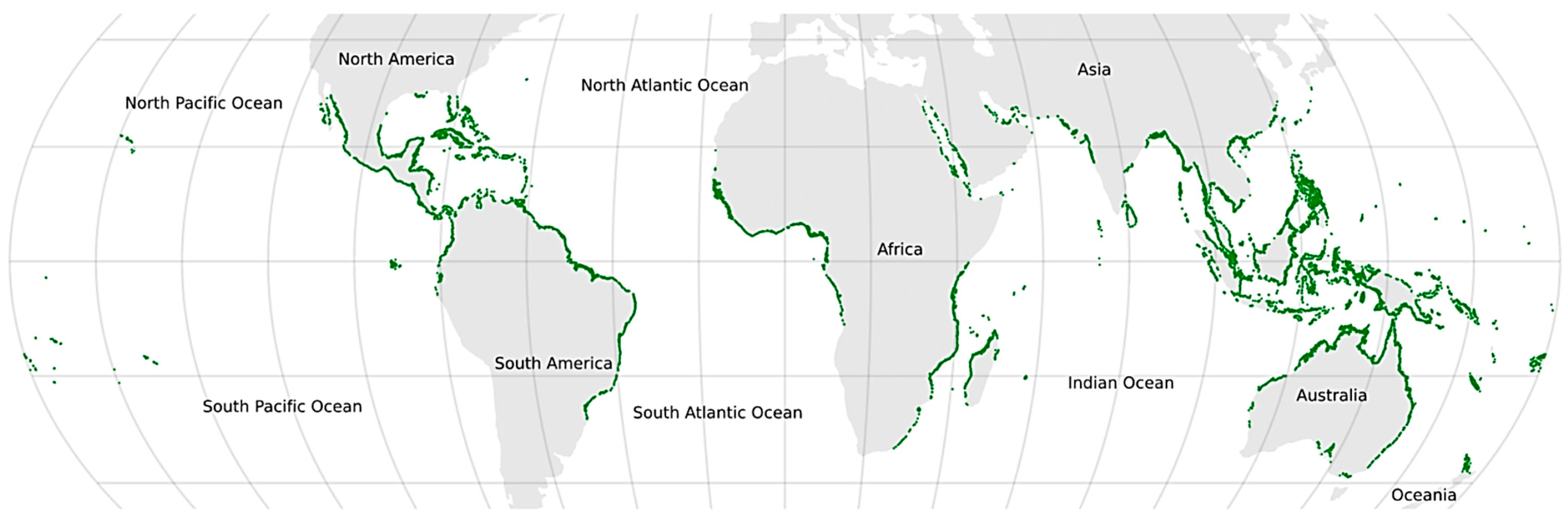
Figure 1. Global Geographic Distribution of Mangrove Forests across Tropical and Subtropical Coastal Zones. Reproduced from [35], licensed under CC BY 4.0.
Geomatics 06 00029 g001
Figure 2. Global Terminology Map of Tropical Cyclones.
Geomatics 06 00029 g002
Figure 3. PRISMA Flow Diagram.
Geomatics 06 00029 g003
Figure 4. Conceptual framework illustrating the logical pathway from tropical cyclone occurrence through remote sensing-based impact assessment to policy application. Author-generated synthesis figure; see Section 3.1 for full discussion.
Geomatics 06 00029 g004
Figure 5. Remote Sensing Sensor Comparison. Values for each parameter: spatial resolution (m), revisit time (days), and number of spectral bands have been normalized using min–max normalization scaled to a range of 0 to 1 to enable visual comparison across variables with different units. Higher normalized values indicate relatively higher performance within the range of sensors compared. Raw values used for normalization are as follows: Sentinel-1 (10 m, 6 days, 1 band); Sentinel-2 (10 m, 5 days, 13 bands); Landsat-8/9 (30 m, 16 days, 11 bands); MODIS (250 m, 1 day, 36 bands); ALOS (10 m, 46 days, 4 bands). Author-generated synthesis figure.
Geomatics 06 00029 g005
Figure 6. Workflow diagram synthesizing common remote sensing techniques for post-cyclone impact assessment, categorized by sensor type, processing methods, and indices applied. Author-generated synthesis figure; see Section 3.3 for full discussion.
Geomatics 06 00029 g006
Figure 7. Time-Series Analysis.
Geomatics 06 00029 g007
Figure 8. Pathway of ecosystem service disruption following tropical cyclone events, linking mangrove degradation to broader economic implications. Author-generated synthesis figure; see Section 3.5 for full discussion.
Geomatics 06 00029 g008
Figure 9. Geographic Distribution of Reviewed Studies.
Geomatics 06 00029 g009
Figure 10. Framework for integrated cyclone impact assessment and resilience planning using multi-sensor remote sensing. Author-generated synthesis figure; see Section 3.7 for full discussion.
Geomatics 06 00029 g010
Table 1. Remote Sensing Tools and Applications.
SensorTypeSpatial ResolutionTemporal ResolutionApplication (Inundation/Vegetation)Limitations
Sentinel-1SAR10 m6–12 daysInundation mappingSpeckle noise
Sentinel-2Optical10–20 m5 daysVegetation health/damageCloud cover
Landsat-8/9Optical30 m16 daysLong-term trend analysisLower revisit
Table 2. Common Vegetation and Damage Indices Used.
IndexFormulaApplicationStrengthsWeaknesses
NDVI(NIR − Red)/(NIR + Red)Vegetation healthWidely usedSensitive to clouds
NDWI(Green − NIR)/(Green + NIR)Water detectionHighlights water bodiesMisclassification in wet soils
EVIG × (NIR − Red)/(NIR + C1 × Red − C2 × Blue + L)Vegetation health in dense forestsImproved sensitivity in high biomass areas, minimizes atmospheric and soil background effectsMore complex and sensor-dependent
Table 3. Summary of Ecosystem Service Valuation Methods.
MethodDescriptionExample ApplicationStrengthsLimitationsReferences
Market PriceUse of actual market dataTimber/fish valuesSimple if data existsLimited to traded goods[86,88,98,99]
Benefit TransferApplying values from similar settingsCarbon storageCost-effectiveRequires contextual similarity[26,49,100]
Contingent ValuationSurveys on willingness to payStorm protectionIncludes non-market valuesTime consuming, bias risk[32,83,98]
Table 4. Limitations and Challenges Identified in the Literature.
CategoryChallengeExplanationReferences
DataCloud covers post-cycloneObstructs optical data[29,70,90,92]
Limited access to high-resolution imageryCost constraints and availability issues restrict the use of 1–5 m imagery[29,69]
MethodsLack of validationFew ground-truth datasets[52,56,66,83]
Absence of standardized classification schemesHinders consistent cyclone impact quantification across studies[51,75,80]
Over-reliance on areal change detectionUnderrepresents functional and ecological changes[70,83]
ScaleLimited local contextGlobal methods not scalable[32,78]
Socioeconomic IntegrationWeak link to economic or policy dimensionsMinimal inclusion of valuation or actionable planning outcomes[32,79,83]
ValidationAbsence of participatory or community-based validationNeglects local perceptions and socio-economic impacts[96,97]
ProcessingResolution mismatch and complexity in data fusionComplicates sensor integration and hinders analysis[53,72]
Disclaimer/Publisher’s Note: The statements, opinions and data contained in all publications are solely those of the individual author(s) and contributor(s) and not of MDPI and/or the editor(s). MDPI and/or the editor(s) disclaim responsibility for any injury to people or property resulting from any ideas, methods, instructions or products referred to in the content.