1. Introduction
Landscapes are complex and dynamic systems resulting from the interaction between natural, geomorphological, ecological and hydrological processes, and social, cultural and economic processes such as land use, territorial planning, demographic dynamics or social values [
1,
2]. In recent decades, these interactions have accelerated considerably due to extensive urbanisation, the expansion of intensive agriculture, climate change, transport infrastructure and other pressures affecting fragmented ecosystems [
3]. As a consequence, landscape transformations (including changes in land use, loss of ecological connectivity, increasing spatial heterogeneity and the degradation of cultural values) have become more frequent and more profound [
4,
5].
In this context, the need has strengthened for mechanisms that allow landscapes to be observed, monitored, compared, identified and even anticipated, with the purpose of informing planning, conservation and restoration policies, as well as involving citizens in environmental governance [
6]. One such emerging mechanism is the landscape observatory, conceived as an instrument that integrates systematic data collection, spatial and temporal analysis, dialogue among actors and a prospective vision [
7].
The notion of the landscape observatory is closely linked to the normative and conceptual development of the European Landscape Convention (ELC) [
8]. In its recommendations for the implementation of the Convention, the Council of Europe has identified observatories (centres or analogous bodies for the study of landscape) as useful instruments for “observation on the basis of appropriate study protocols, information exchange, the generation of experiences and policies” [
9] (p. 3). Since the adoption of the Convention, successive implementation documents and policy guidance prepared by the Council of Europe have progressively reinforced this role, presenting landscape observatories as long-term mechanisms for monitoring landscape change, facilitating knowledge exchange and supporting public participation in landscape policies [
8,
9]. In this sense, observatories do not only fulfil a technical function but also operate as nodes of integration between public administrations, the scientific community, territorial managers and citizens [
10]. The progressive incorporation of landscape observatories into planning systems has also been interpreted as one of the practical consequences of the implementation of the European Landscape Convention in several European countries, particularly Spain and Italy [
11].
Interest in landscape observatories has grown in Europe since the late 1990s and early 21st century [
12], with pioneering experiences in Italy, Finland, Catalonia, regions of France and Portugal and, subsequently, regional or national networks [
2,
13,
14,
15]. These early experiences have served as a conceptual laboratory for reflecting on the institutional functions, methodological mechanisms and potential effects of these instruments on landscape governance [
16].
Although Europe has played a leading role in the conceptual and institutional development of landscape observatories, related initiatives have progressively emerged in other regions through different institutional pathways. In North America, the concept has often been associated with long-term ecological observation infrastructures and landscape monitoring programmes, whereas in Latin America it has been linked to cultural landscapes, territorial heritage and landscape governance initiatives. More recently, studies from Asia have explored landscape observatories as platforms integrating remote sensing, digital technologies and long-term monitoring of landscape change, including repeat-photography programmes developed in high mountain environments [
16,
17,
18,
19,
20].
Despite these advances, the term landscape observatory does not have a single, consensual definition in the literature. Some authors conceive it as a technical platform for continuous monitoring and the generation of spatial indicators; others attribute to it a broader role as a space for mediation among actors, a knowledge interface and a promoter of public participation. For example, Ternell et al. [
21] argue that observatories should be conceived as multifunctional platforms integrating sensors, remote data, citizen science and decision-support systems. In another recent study, Sahin and Dogan [
16] propose a technological and structural framework that emphasises interoperability, distributed governance and modular design. Likewise, Galán Vivas [
22] suggests that observatories can be analysed through institutional, organisational and operational variables in order to generate comparisons between cases.
These conceptual divergences translate into heterogeneity in operational scales (local, regional, national), thematic scopes (ecological, cultural, urban, social) and adopted methodologies (photomonitoring, GIS, sensors, participation, qualitative reporting) [
23,
24]. Among these approaches, repeat photography has become one of the most widely used techniques for documenting long-term landscape dynamics and supporting planning and management processes [
25,
26]. This poses a double challenge: on the one hand, it hinders systematic comparison between cases; on the other, it opens space for innovation adapted to specific contexts.
When designing or operating a landscape observatory, researchers and managers face several tensions and challenges [
27,
28,
29,
30]: (i) scale and scope of the observatory: territorial extent and temporal and spatial resolutions. Some favourable experiences are concentrated in protected areas such as Sierra Nevada (Spain) [
10], where photographic methods and local participation are combined; (ii) indicator selection: balancing ecological, structural, landscape, cultural and perceptual indicators [
31]. Some studies draw on the DPSIR model (Drivers–Pressures–State–Impact–Response) as a conceptual framework to organise indicators; (iii) citizen participation and governance: how to incorporate non-academic actors, promote dialogue, valorise local knowledge and ensure political legitimacy; (iv) data interoperability and continuous updating: integrating remote sensors, GIS, administrative data and citizen-generated data, with open standards that allow comparability, systematisation and periodicity; (v) impact evaluation and institutional sustainability: how to measure whether an observatory has effectively influenced territorial policies, landscape planning or restoration, and how to ensure its financial, institutional and technical continuity [
7].
These tensions require a flexible, modular and scalable approach that allows adaptation to different contexts while maintaining a certain degree of conceptual coherence. The aim of this article is to carry out a systematic review of the scientific literature on landscape observatories with the objectives of: (i) identifying and discussing the principal functions attributed to landscape observatories in the scientific literature; (ii) identifying the main institutional models and organisational approaches reported in the literature; (iii) describing the methodologies used to monitor landscapes (indicators, frequency, data sources, use of GIS, sensors and citizen participation); (iv) analysing trends over time, geographical distribution and thematic focus of publications: how many articles, in which countries, in which fields they dominate, and identifying knowledge gaps; (v) examining how the literature addresses the potential contribution of landscape observatories to public policies, territorial planning, environmental management, restoration and dialogue with local actors; and (vi) proposing recommendations to strengthen future observatories, promote inter-territorial comparative networks, and improve the methodological and functional integrity of the concept. A distinctive contribution of this study is the development of an original comparative database comprising 188 landscape observatories and related initiatives worldwide. This dataset complements the bibliometric review by providing a structured overview of existing initiatives and supporting the comparative interpretation of their geographical distribution, operational scales and methodological orientations.
2. Materials and Methods
2.1. Review Design and PRISMA Compliance
This study combines a systematic literature review with bibliometric analysis and the development of an original international database of landscape observatories and related initiatives. The systematic review was designed and reported in accordance with the recommendations of the Preferred Reporting Items for Systematic Reviews and Meta-Analyses (PRISMA 2020) Statement [
32], following a transparent, structured and reproducible workflow for the identification, screening, eligibility assessment and qualitative synthesis of the scientific literature.
Although PRISMA was originally developed within the health sciences, its methodological framework has been widely adopted in systematic reviews across environmental sciences, geography and territorial studies because it provides explicit procedures for documenting literature searches, study selection and evidence synthesis [
32,
33]. Likewise, bibliometric analysis has become a well-established approach for examining the evolution, geographical distribution, thematic structure and intellectual organisation of emerging scientific fields [
34,
35,
36].
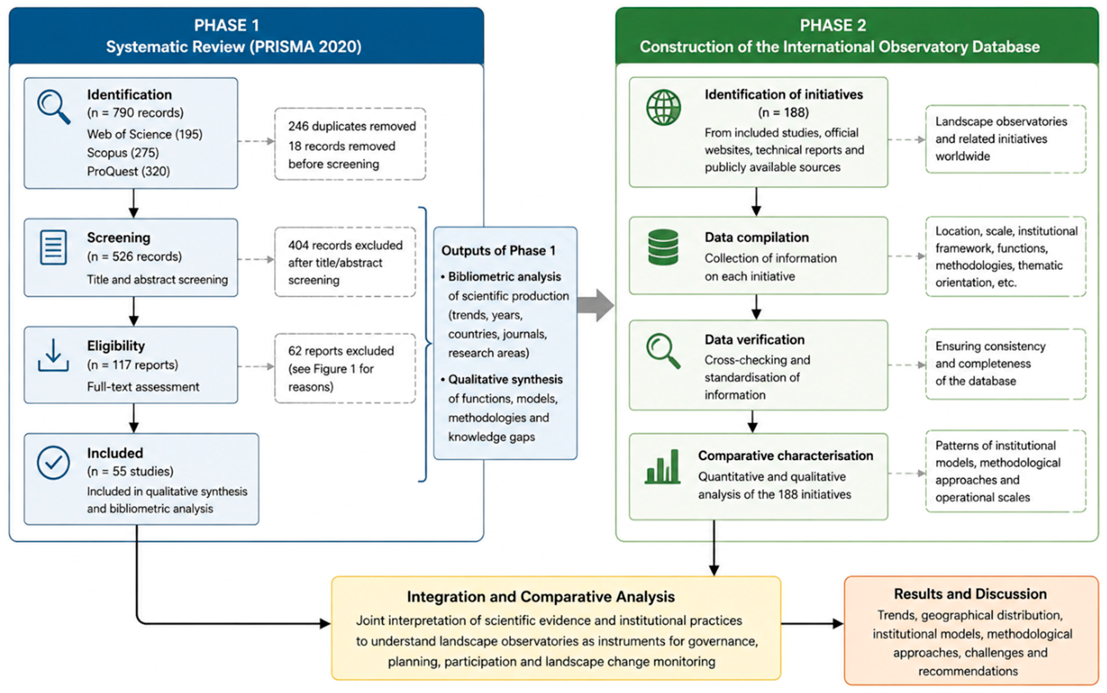
The research was organised into two complementary methodological phases. The first consisted of a systematic review of the scientific literature addressing landscape observatories as institutional, methodological or governance instruments. This review provided the conceptual basis for a bibliometric analysis describing the temporal evolution, geographical distribution and thematic orientation of scientific production. The second phase comprised the development of an original comparative database of landscape observatories and related initiatives worldwide, allowing the organisational and methodological characteristics identified in the literature to be contrasted with existing institutional experiences.
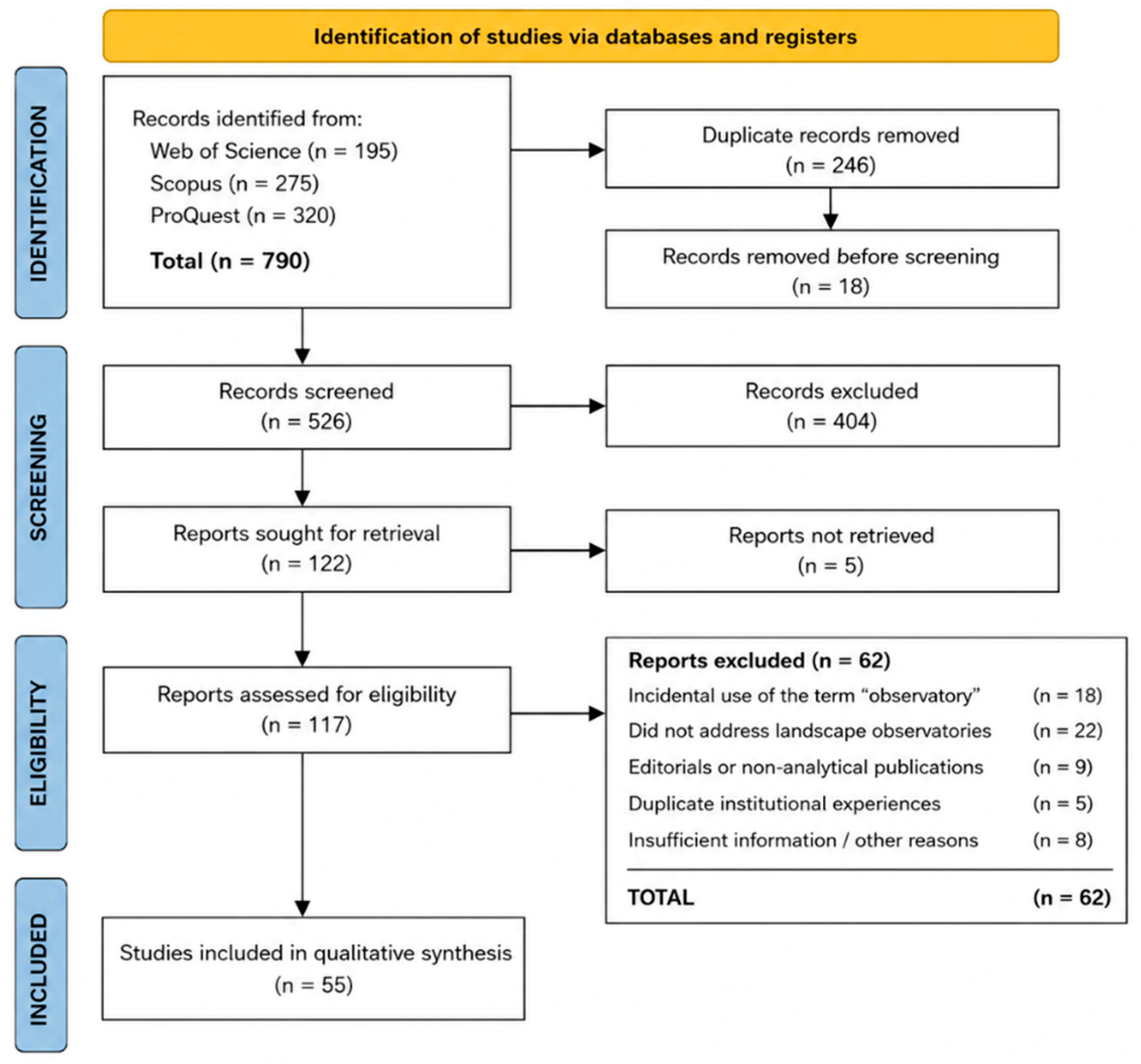
The study selection process followed the four stages recommended by the PRISMA framework (identification, screening, eligibility and inclusion). The detailed results of each stage are presented in
Section 2.3.
The overall methodological framework is summarised in
Figure 1. As illustrated, the study was structured into two complementary phases. Phase 1 followed the PRISMA 2020 workflow to identify, screen and synthesise the relevant scientific literature while also providing the basis for the bibliometric analysis. Phase 2 focused on the construction, verification and comparative analysis of an original international database comprising 188 landscape observatories and related initiatives. Although conceptually linked, only the first phase constitutes the systematic review and therefore follows the PRISMA reporting framework. No review protocol was registered prior to conducting this study because the review combined a systematic literature review with an original comparative institutional database that evolved iteratively during the research process.
2.2. Information Sources and Search Strategy
The bibliographic search was conducted using three multidisciplinary databases recognised for their extensive scientific coverage and metadata quality: Web of Science (WoS), Scopus (SC) and ProQuest (PQ). The combined use of these databases provides broad coverage of peer-reviewed scientific literature while reducing the risk of omitting relevant publications from different disciplinary traditions [
37,
38].
Searches were conducted between 15 January and 28 February 2024, and the databases were last updated on 28 February 2024. An unrestricted temporal range was adopted, extending from the earliest records indexed in each database to the end of 2023, in order to capture the complete historical evolution of the concept.
The search strategy was designed to maximise sensitivity while maintaining conceptual specificity. The exact expression “Landscape Observatory” constituted the principal search term and was applied to titles, abstracts and keywords. Additional linguistic variants, including “Landscape Observatories” and “Observatorio de Paisaje”, were considered whenever they appeared in publications indexed with English or Spanish metadata. Because bibliographic databases retrieve exact lexical matches independently of their contextual meaning, all retrieved records were subsequently examined individually to distinguish publications genuinely referring to landscape observatories from incidental or metaphorical uses of the term.
The complete database-specific search strategies, including search fields, Boolean operators, filters and retrieval dates, are provided in
Supplementary Table S1, thereby ensuring the reproducibility of the review process in accordance with PRISMA 2020 recommendations [
32].
2.3. Eligibility Criteria and Study Selection
Eligibility criteria were established prior to the screening process. Publications were considered eligible when they explicitly addressed landscape observatories as institutional structures, methodological frameworks or governance instruments for landscape observation, monitoring, planning or management. Scientific articles, review papers, conference papers, book chapters and doctoral theses containing sufficient methodological or conceptual information were considered for inclusion. A detailed summary of the inclusion and exclusion criteria applied during the review process is provided in
Supplementary Table S2.
Records were excluded when the term landscape observatory was used only incidentally or metaphorically, when the publication referred to observatories unrelated to landscape observation (for example, astronomical or meteorological observatories), when the document consisted solely of editorials, news items or other publications lacking analytical content, or when duplicate publications reported the same institutional experience without providing additional relevant information.
All retrieved references were exported to a Microsoft Excel database specifically created for this review. Duplicate records were removed before screening. Subsequently, titles and abstracts were independently examined by two reviewers (A.C.-C. and Y.J.O.) to assess their potential relevance. Publications considered potentially eligible underwent full-text assessment. Any disagreements during the screening or eligibility assessment were resolved through discussion until consensus was reached and, when necessary, by consultation with a third reviewer (R.P.-A.).
The systematic search identified 790 records (195 from Web of Science, 275 from Scopus and 320 from ProQuest). After the removal of 246 duplicate records and 18 records excluded prior to screening, 526 records underwent title and abstract screening. Following full-text assessment of 117 publications, 55 studies met the eligibility criteria and were included in the qualitative synthesis. The complete study selection process is illustrated in the PRISMA 2020 flow diagram (
Figure 2). No automation tools or machine-learning approaches were used during screening or study selection.
2.4. Data Extraction and Synthesis
For each included publication, a predefined data extraction form was completed. The extracted variables comprised publication year, country of origin, journal or publication source, document type, research area, territorial scale, methodological approaches, principal functions attributed to landscape observatories and institutional orientation. Whenever necessary, additional contextual information was obtained directly from the full text of each publication. Data extraction was conducted independently by two reviewers, and discrepancies were resolved through discussion until consensus was reached.
The subsequent analysis combined complementary quantitative and qualitative approaches.
The bibliometric analysis was performed on the complete dataset retrieved from the three bibliographic databases in order to characterise overall publication trends, temporal evolution, geographical distribution, research areas and journal dispersion. Descriptive statistics were calculated and represented using tables and graphical summaries.
The qualitative synthesis was conducted exclusively on the publications fulfilling the eligibility criteria after full-text assessment. These studies were analysed comparatively to identify recurring conceptual frameworks, institutional models, governance approaches, methodological strategies and emerging research gaps. Because several qualitative variables were not reported consistently across all publications, the synthesis emphasised descriptive comparison rather than formal statistical analysis.
The complementary use of bibliometric analysis and qualitative evidence synthesis allowed quantitative publication patterns to be interpreted alongside the conceptual and organisational characteristics of landscape observatories, thereby providing a more comprehensive understanding of the evolution of this emerging field [
34,
35,
36].
2.5. Compilation of the International Database of Landscape Observatories
In parallel with the systematic review, an original international database comprising 188 landscape observatories and related initiatives was developed to complement the evidence obtained from the scientific literature. Whereas the systematic review focused exclusively on published scientific evidence, the database aimed to characterise existing institutional experiences regardless of their level of academic publication.
The database was compiled through the systematic examination of the publications included in the qualitative synthesis, complemented by information obtained from official institutional websites, technical reports and publicly available documentation whenever additional information was required to characterise individual initiatives. For each observatory, information was collected regarding geographical location, territorial scale, institutional framework, principal functions, methodological approaches and thematic orientation.
The resulting database was subsequently used to compare the organisational and operational characteristics of existing landscape observatories with the patterns identified through the systematic review. This second methodological phase therefore extends the bibliometric analysis beyond scientific production by providing an empirical overview of the institutional diversity of contemporary landscape observatories.
3. Results and Discussion
The results are organised according to the two-phase methodological framework presented in
Figure 1. The first part reports the findings of the systematic review and bibliometric analysis, providing an overview of the scientific development of landscape observatories. The second part presents the comparative analysis of an original international database comprising 188 landscape observatories and related initiatives, allowing the scientific evidence to be contrasted with current institutional practice.
3.1. Scientific Production on “Landscape Observatory”
The study selection process is summarised in the PRISMA 2020 flow diagram (
Figure 2). The systematic search identified 790 records across the three selected databases. Following duplicate removal, screening and full-text assessment, 55 studies met the eligibility criteria and were included in the qualitative synthesis. While these publications constituted the evidence base for the systematic review, the complete bibliographic dataset was retained for descriptive bibliometric analyses of publication trends and research evolution.
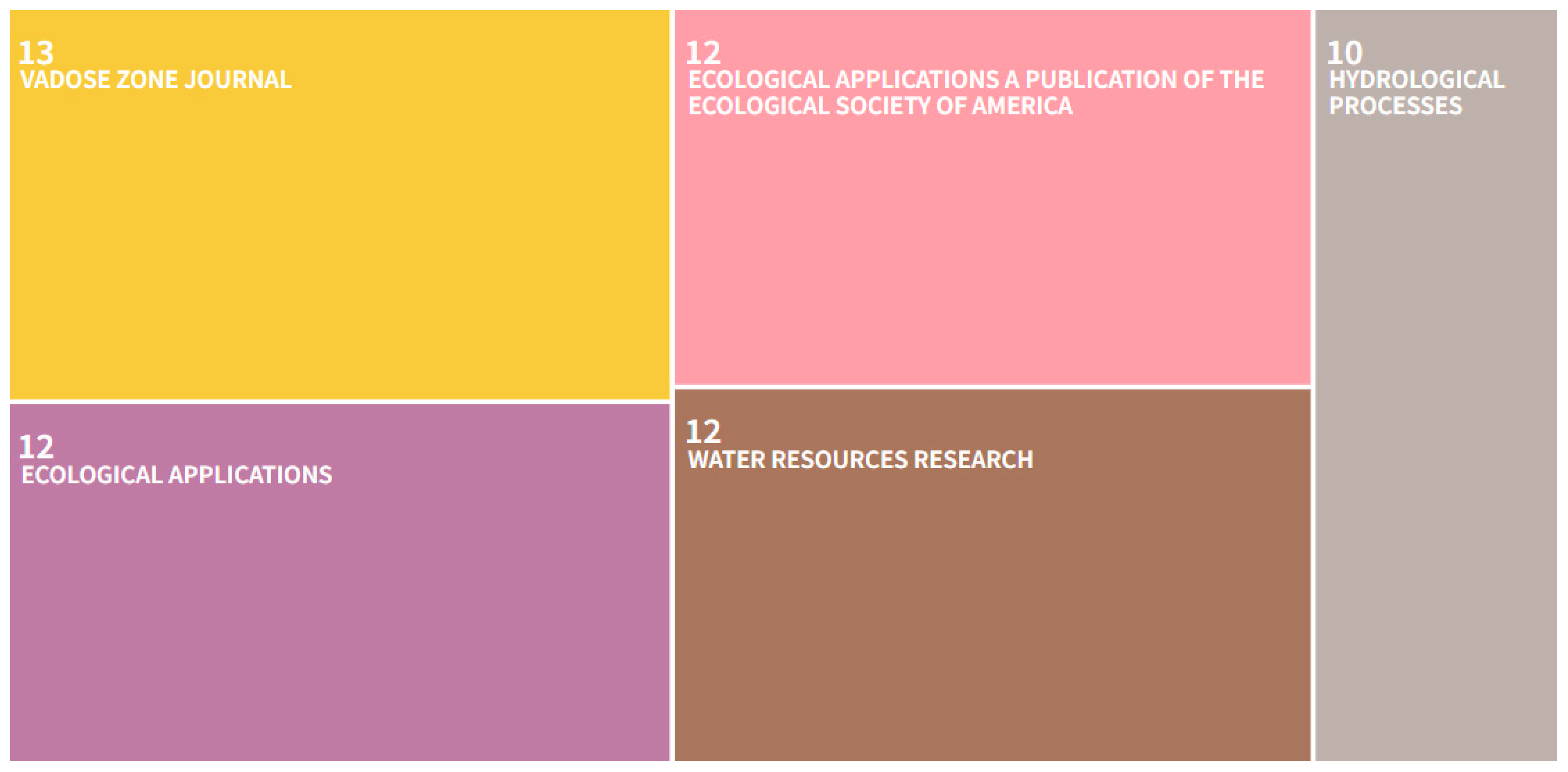
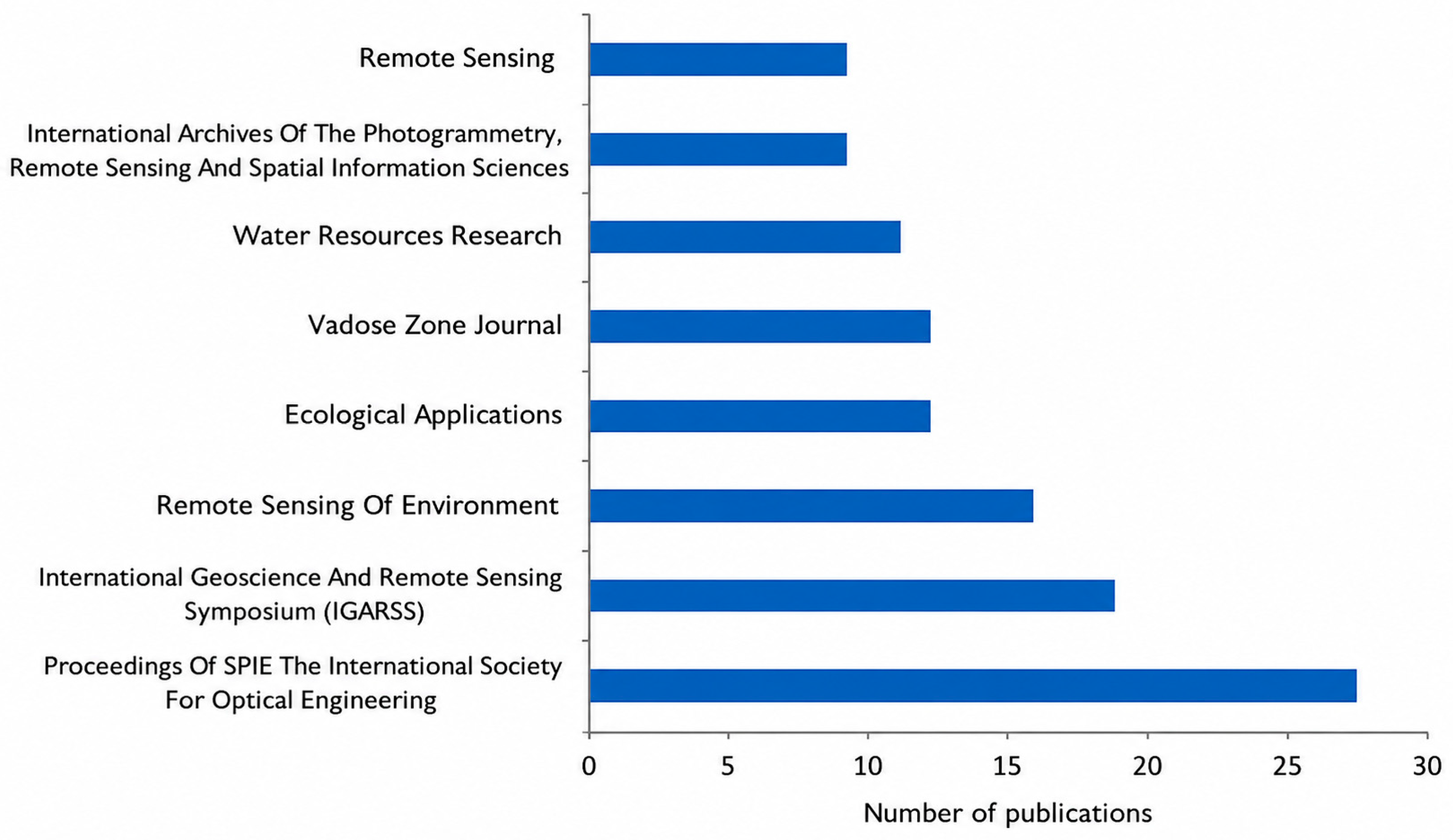
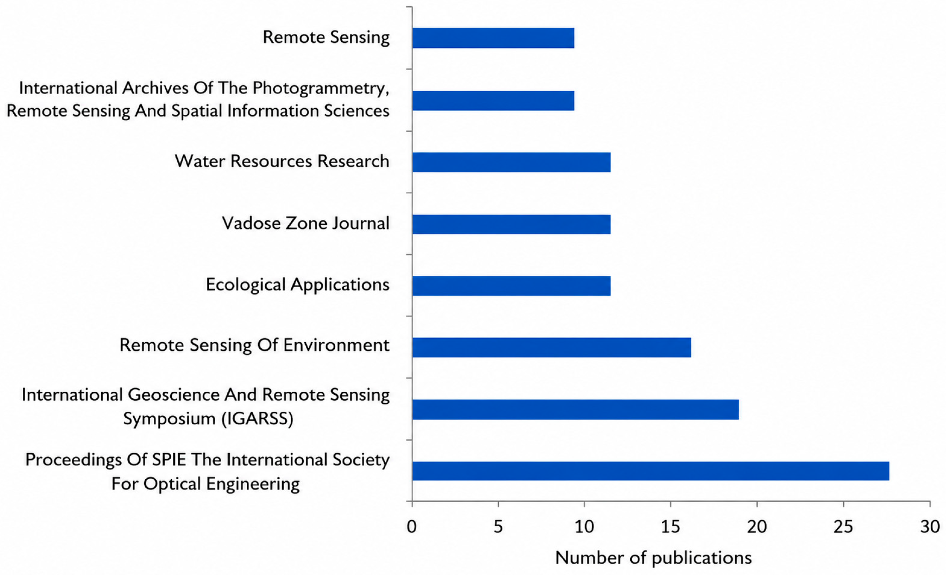
First, it should be noted that the concept of the landscape observatory does not emerge from a single discipline or from a closed theoretical framework but rather develops at the intersection of several fields: geography, territorial planning, landscape architecture, landscape ecology and, more recently, environmental governance. This hybrid condition explains why publications are not concentrated in a single dominant journal or scientific community but instead are disseminated across multiple academic forums with different orientations and traditions (
Figure 3). This disciplinary dispersion also reflects the very nature of observatories: rather than being purely scientific institutions, they are intermediate structures that combine observation, analysis, communication and, in some cases, influence on public policies [
16,
39,
40].
The conceptual trajectory of landscape observatories is deeply linked to the development of political and normative frameworks that have promoted the integration of landscape into territorial planning and management, particularly in the European context. The European Landscape Convention (ELC) represents a central milestone: it not only defined landscape as a common good and an essential component of cultural identity, but also explicitly encouraged Member States to create monitoring and observation instruments. In this context, observatories emerge as cognitive and participatory infrastructures designed to collect systematic information, promote social participation and translate landscape knowledge into public policies [
8,
41].
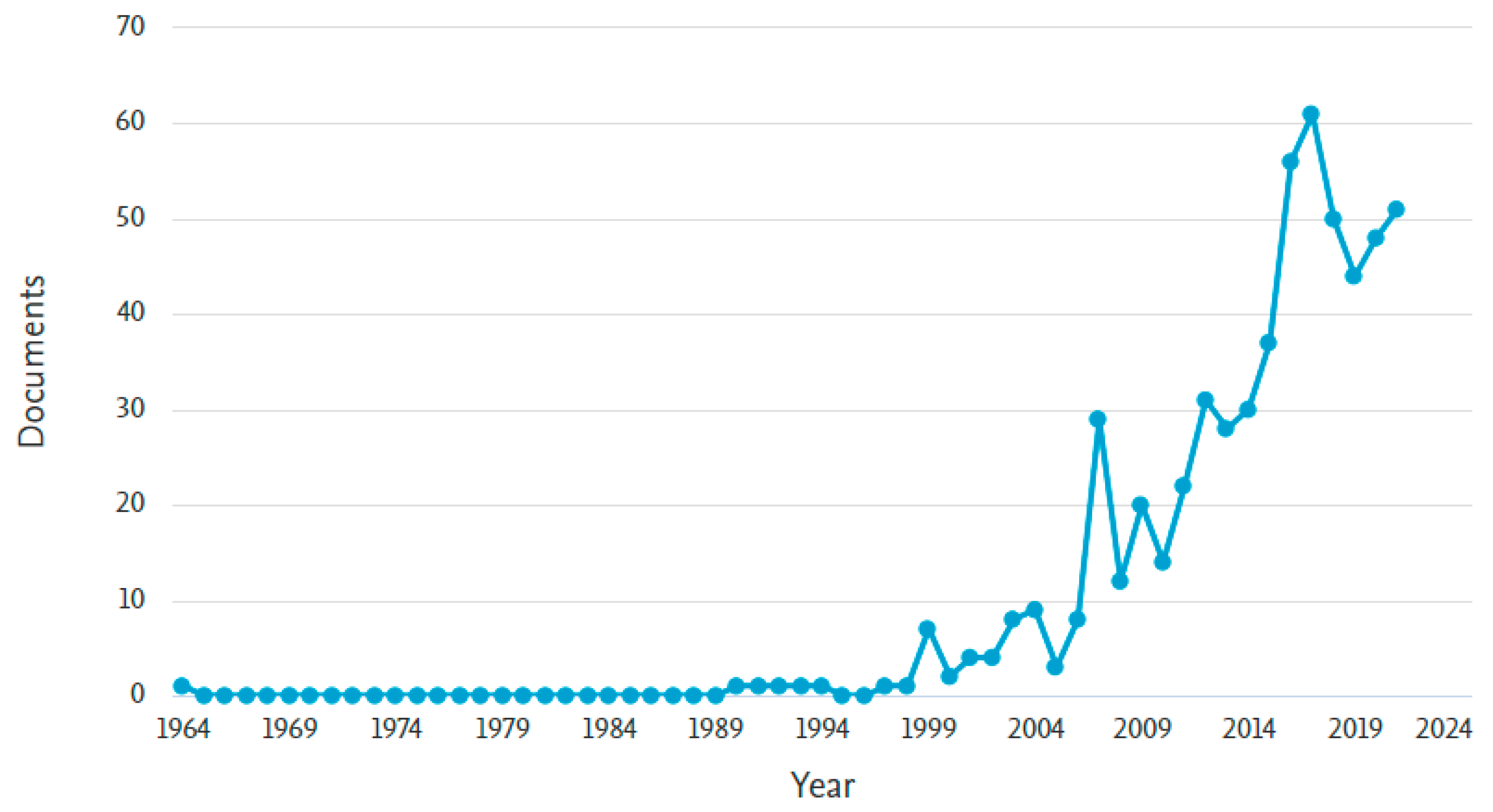
If we observe the evolution of scientific publications, it can be seen that the term “Landscape Observatory” begins to appear significantly in indexed literature from the mid-2000s onwards, coinciding with the phase of institutional consolidation of landscape policies in Europe. Nevertheless, the earliest Scopus record retrieved by the search dates back to 1964. However, this early occurrence does not necessarily refer to a landscape observatory in the contemporary institutional sense adopted in this study. Rather, the sustained scientific use of the concept as an instrument of landscape governance only became evident from the mid-2000s onwards, following the implementation of the European Landscape Convention.
In its early decades, references to the term were mainly linked to scientific research initiatives, particularly in landscape ecology and visual documentation, whereas from 2000 onwards a clear shift towards institutional, political and governance-related uses can be observed [
42]. This change in focus is relevant because it marks the transition of the concept from a scientific observation instrument to a tool for territorial governance. Unlike other notions used in ecology or geography (such as landscape monitoring or landscape assessment), the landscape observatory implies a stable institutional framework, with mechanisms for continuous observation, interaction among actors and potential political influence. This explains why, as the concept gains ground in territorial planning, its presence increases in planning, urbanism and environmental management journals, in addition to geographical and ecological literature (
Figure 3,
Figure 4 and
Figure 5).
Another fundamental aspect emerging from the analysis is the predominantly European character of the conceptual and political construction of landscape observatories. Both in scientific literature and in institutional experiences, Europe (particularly France, Italy, Spain and Switzerland) occupies a central position. This geographical leadership has a clear institutional explanation: the impetus provided by the European Convention and the creation of specialised bodies (such as the Observatori del Paisatge de Catalunya, OPC, or LABES, in Switzerland) have served as models for other countries and regions [
16,
36]. In France, the network of Observatoires Photographiques du Paysage, established in the 1990s, represents one of the pioneering examples of systematic observation, with standardised methodologies for repeat photography and long-term visual analysis [
13,
14]. This tradition also stimulated participatory approaches that conceive landscape observation as a mechanism for territorial dialogue rather than solely as technical monitoring [
24].
However, although Europe has been the epicentre, the notion of the “landscape observatory” has begun to expand modestly to other contexts, particularly in North America and some Latin American countries. In the United States, the term more frequently appears linked to visual documentation programmes, cultural landscape research projects or landscape ecology, rather than to institutionalised structures of permanent observation [
43]. In Latin America, its presence in international databases remains marginal, which may be due both to the limited institutional adoption of the concept and to the reduced indexation of regional publications [
44]. This geographical asymmetry represents one of the main challenges for the future development of the field, highlighting the uneven international distribution of both institutional experiences and scientific production.
A further structural characteristic of the analysed corpus is its relative thematic fragmentation. Although most articles are located within broad disciplinary areas such as territorial planning, geography or environmental sciences, the way in which they conceptualise and operationalise the “landscape observatory” varies considerably. Some studies understand the observatory as a technical platform for the collection and analysis of spatial data (for example, through remote sensing or GIS), while others conceive it as a participatory infrastructure combining scientific monitoring and citizen participation [
16,
39]. This diversity can be interpreted as a strength, reflecting conceptual richness and adaptability of the model, but also as a limitation, as it hampers the development of comparable indicators and methodologies at the international scale.
From a bibliometric perspective, this heterogeneity translates into a significant dispersion of publications across different journals (
Figure 2,
Figure 3 and
Figure 4), an absence of hegemonic authors, and a concentration of case studies in a limited number of countries. All of this indicates that the field is still in a phase of consolidation: there are well-defined conceptual cores in Europe, but the literature has not yet reached a sufficient level of maturity to configure a robust and articulated transnational scientific community [
45]. Nevertheless, it is precisely at this early stage that the conceptual frameworks guiding the future evolution of the field are defined, as has previously occurred in related disciplines such as landscape planning or landscape ecology [
46,
47].
In summary, this general overview makes it possible to state that the concept of the landscape observatory has evolved from being a dispersed term in scientific literature to becoming an emerging reference for thinking about the relationship between territorial knowledge, public policies and governance. Its development has been driven by European institutional frameworks, but its potential expansion will depend on the capacity to integrate different scientific traditions, broaden its geographical scope and generate methodological tools that allow rigorous evaluation of its impact.
Beyond describing the current state of scientific production, these findings indicate that landscape observatories have evolved from isolated initiatives into a recognised field of research closely linked to territorial governance. The progressive increase in publications also suggests that the concept has moved beyond its initial experimental phase and is becoming an established framework for addressing landscape change, while the observed fragmentation points to the need for greater conceptual and methodological integration.
3.2. Temporal Dynamics and Geographical Distribution of Scientific Production
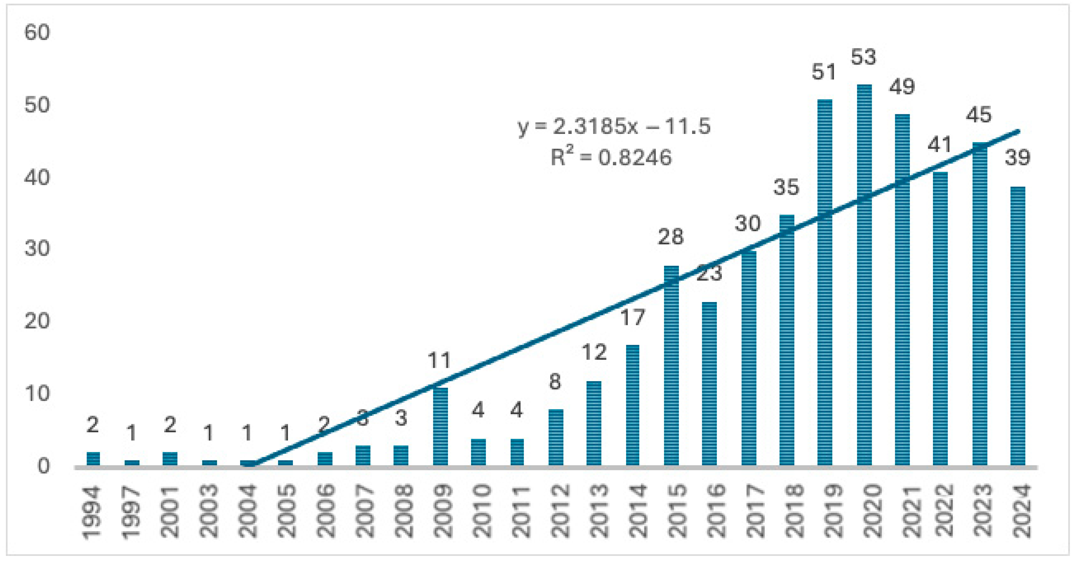
The temporal evolution and geographical distribution of publications containing the term “Landscape Observatory” constitute two closely interrelated dimensions. On the one hand, the sustained growth of scientific production over the last two decades (
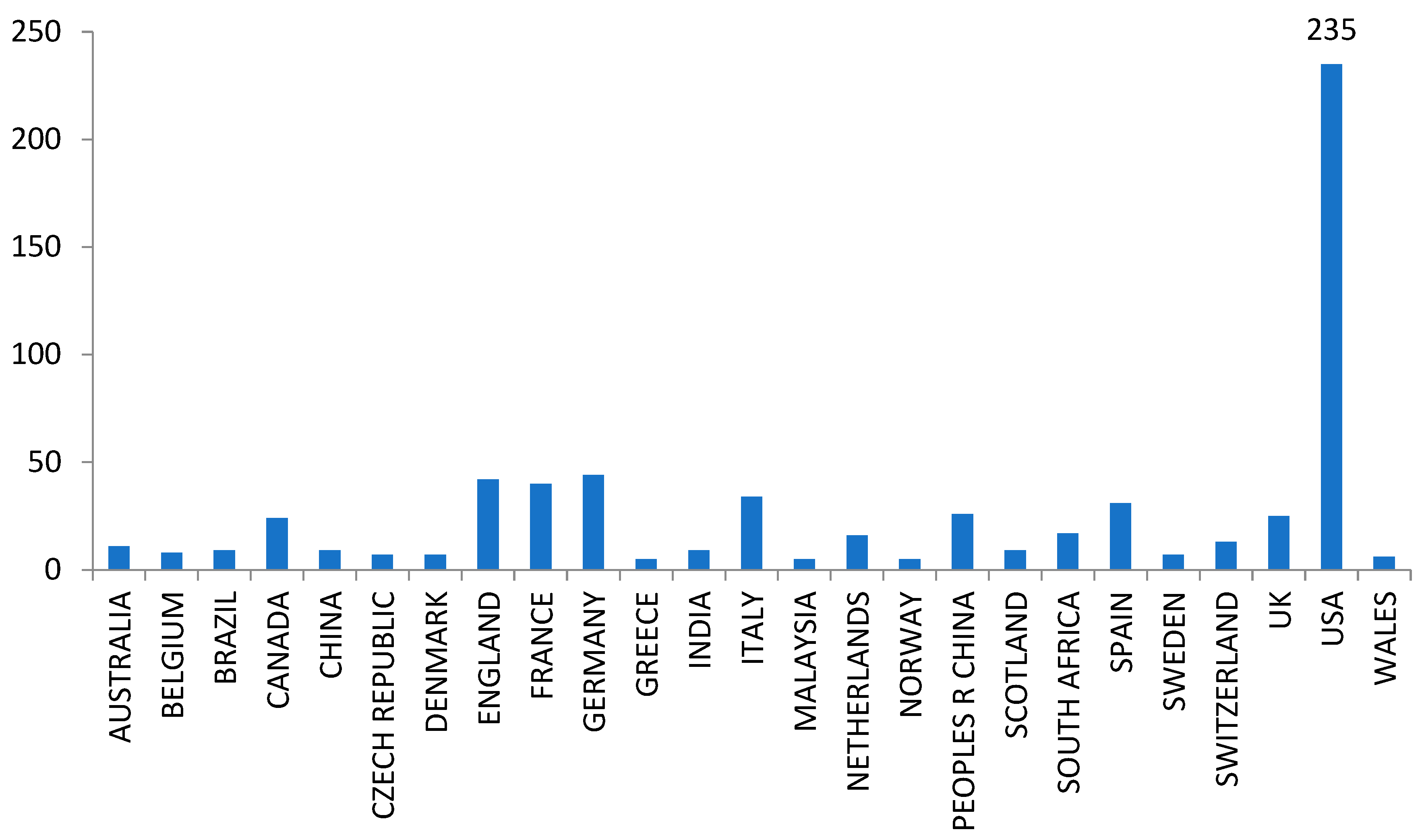
Figure 6) reflects the consolidation of an emerging field that has found its place at the intersection between academic research and territorial governance. On the other hand, the strong geographical concentration of contributions in a small number of countries (
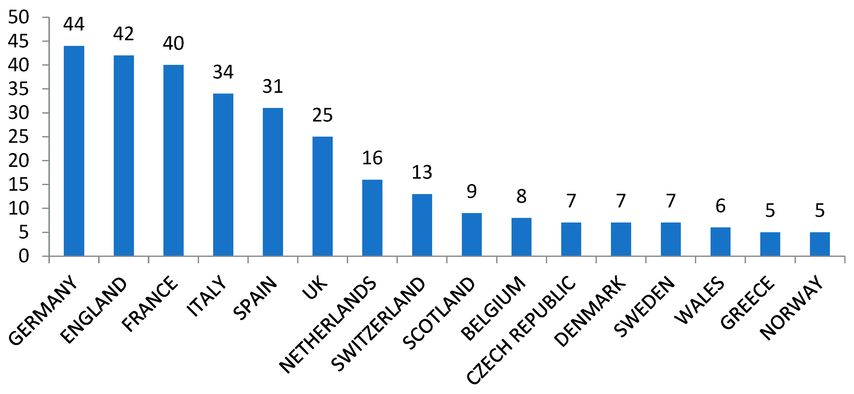
Figure 7), mainly European (
Figure 8), highlights the existence of regional hubs that have driven the institutionalisation of the concept and its international dissemination.
The time series of publications identified in WoS and SC clearly illustrates this trend (
Figure 6 and
Figure 9). Although the first record of the term in Scopus dates back to 1964, it is from the mid-2000s onwards that a notable increase in publications occurs. This rise coincides with the dissemination and implementation of the ELC, signed in 2000 and progressively ratified in different European countries in the following years. This instrument acted as a key catalyst for the creation of institutionalised observatories, such as the Observatori del Paisatge de Catalunya in 2005, LABES in Switzerland or the Observatorio y Archivo de los Paisajes de Andalucía (OAPA), and for the incorporation of landscape as an object of public policy [
2,
7,
17,
22].
This increase in production does not respond solely to conceptual expansion, but also to a change in institutional and methodological scale: landscape observation shifts from being a practice linked to isolated scientific projects to becoming a stable knowledge infrastructure. In the literature of previous decades (1970–1990), landscape was mainly observed from ecological or aesthetic perspectives, whereas from 2005 onwards it became consolidated as an object of governance and planning. This shift also coincides with the emergence of publications oriented towards the integration of mixed methodologies, combining GIS, ecological indicators and participatory analyses [
47,
48].
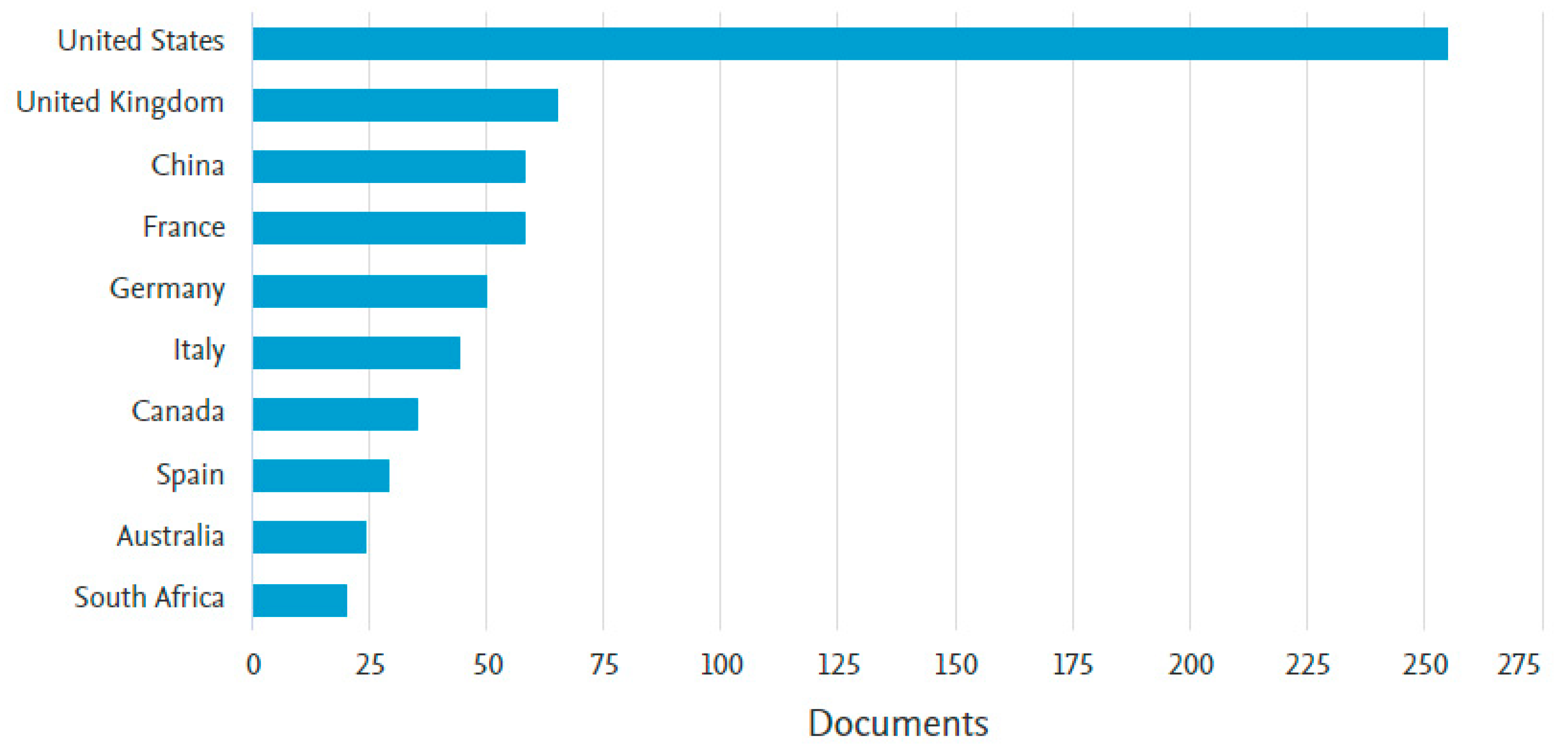
The geographical distribution of publications reinforces this diagnosis. The data show a clear concentration in Western Europe, especially in France, Italy and Spain, followed by Switzerland, the United Kingdom and Germany. The United States also occupies a relevant position, although with a different focus, more closely linked to scientific observation than to institutionalised structures (
Figure 7 and
Figure 10). This distribution is also consistent with the international database of 188 observatory initiatives compiled in this study, which likewise shows a marked concentration of institutional experiences in France, Italy and Spain. It coincides with the geography of landscape policy adoption, with France as a pioneer in the creation of Observatoires Photographiques du Paysage in the 1990s, Italy with the integration of landscape observation into regional planning policies, and Spain with the development of distinctive models of territorial observatories, such as those mentioned in Catalonia or Andalusia.
This map of geographical concentration can be largely explained by institutional and normative factors. France and Italy have developed landscape policies integrated into their urban and territorial planning legislation, which has favoured the creation of observation structures at national and regional levels. The historical role of the DATAR photographic mission in shaping subsequent French landscape observatories has been extensively documented by [
23]. Recent syntheses also confirm the rapid expansion of regional observatories across Italy during the implementation of landscape planning policies [
49]. Switzerland, with LABES, represents a model of systematic and homogeneous monitoring of landscape indicators, while Spain stands out for its more participatory and cultural approach. In contrast, in the United States publications are mainly related to cultural landscape studies, landscape ecology and photographic programmes, such as visual repositories, rather than to institutionalised observatories.
However, this European concentration reveals a significant regional asymmetry. Latin America, Africa and Asia show a marginal presence in the analysed databases. This gap may be due both to the limited institutional adoption of the concept of “landscape observatory” and to lower international indexation of local publications. Nevertheless, recent conceptual developments suggest growing academic interest in landscape-based territorial approaches in Latin America, although these initiatives are still only marginally represented in international bibliographic databases [
19]. This geographical asymmetry raises a crucial question: are landscape observatories becoming consolidated as global tools, or do they remain a Eurocentric innovation?
Recent literature indicates that there are incipient efforts to adapt these models in other regions, but the lack of institutional support, clear legal frameworks and stable funding limits their development. As noted by Galán Vivas and Sahin et al. [
16,
22], for observatories to consolidate as global instruments of landscape governance it is necessary to overcome institutional fragmentation and to establish interregional networks that allow the exchange of methodologies and standards.
In summary, temporal evolution and geographical distribution reveal a progressive but uneven maturation of the field: while Europe concentrates consolidated experiences and scientific production, other regions show an incipient or marginal presence. This imbalance poses significant challenges for international comparability, knowledge transfer and the creation of common frameworks for landscape observation.
The temporal and geographical patterns identified here have practical implications beyond bibliometric description. The concentration of scientific production in a limited number of European countries suggests that institutional support and policy frameworks play a decisive role in the development of landscape observatories. Consequently, expanding the concept to underrepresented regions will require not only academic interest but also appropriate governance structures, long-term institutional commitment and international cooperation.
3.3. Thematic Areas, Document Typologies and Authorship Concentration
Beyond the temporal and geographical patterns discussed in the previous section, bibliometric analysis provides further insight into the thematic domains in which landscape observatory research has developed, the predominant document types, the distribution of publications across scientific journals and the structure of authorship. Together, these dimensions help to characterise the disciplinary profile, scientific organisation and current stage of development of this emerging research field.
The qualitative review of the included studies complements these bibliometric patterns by identifying a series of recurring institutional models and functional orientations. Although these dimensions could not be quantified consistently across all retrieved publications, they provide additional evidence for understanding how landscape observatories have been conceptualised and implemented in the literature.
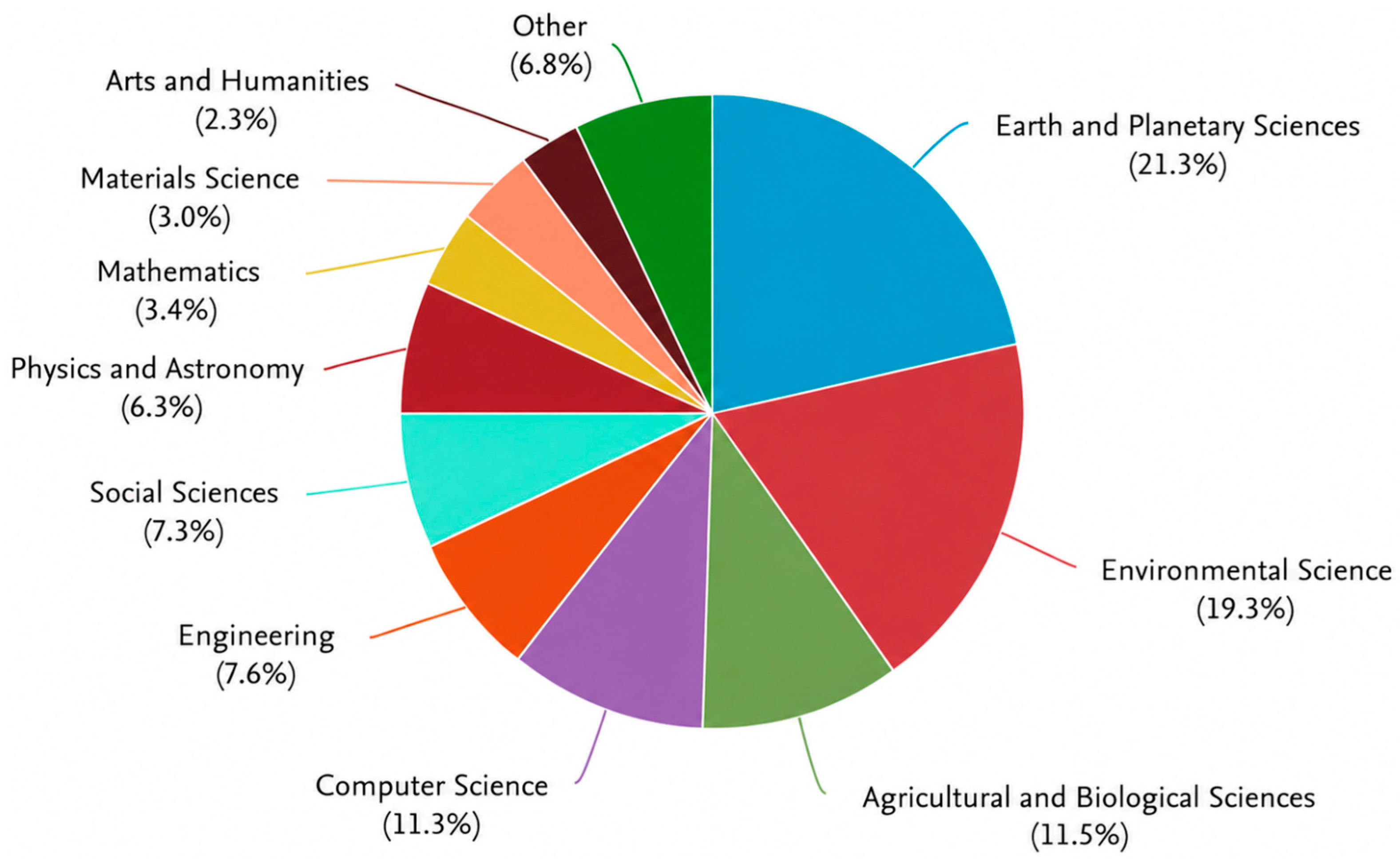
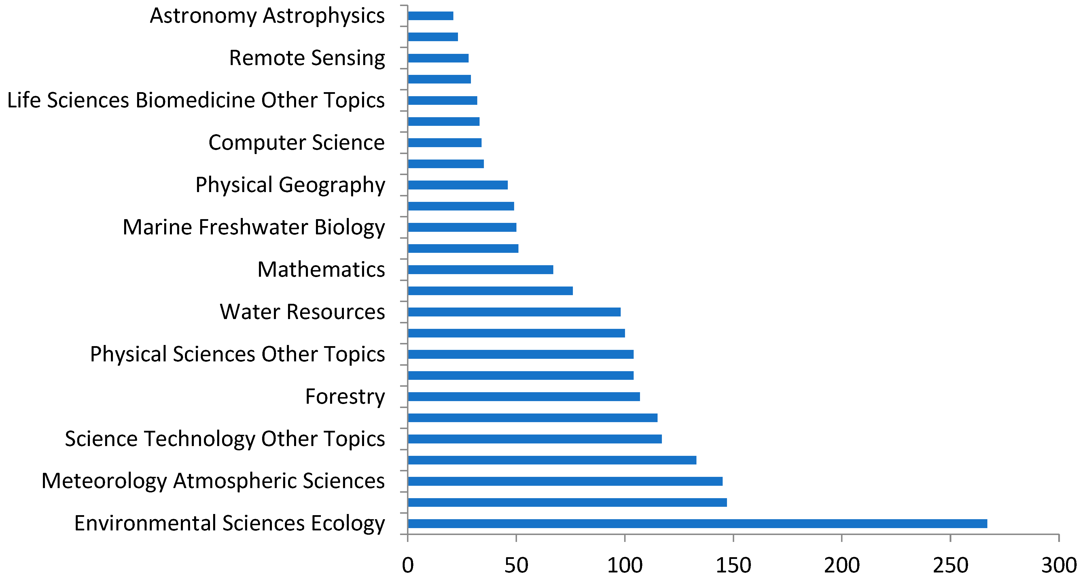
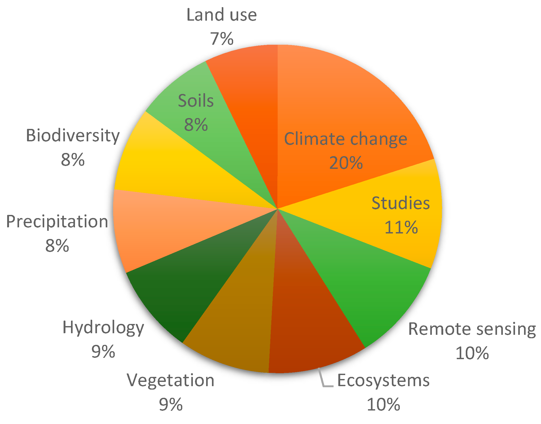
The first aspect to be highlighted is the distribution by thematic areas. Because Web of Science, Scopus and ProQuest use different native subject classification systems, the categories presented in
Figure 11,
Figure 12 and
Figure 13 are not directly equivalent but provide complementary perspectives on the disciplinary profile of landscape observatory research. In Web of Science, the publications are mainly associated with Environmental Studies, Ecology, Physical Geography and related planning disciplines (
Figure 11). Scopus reveals a broadly comparable disciplinary profile, although organised according to its own subject classification scheme (
Figure 4), while ProQuest slightly broadens the spectrum by including a greater proportion of publications related to environmental humanities, art history and cultural studies (
Figure 12). Overall, these patterns confirm the intrinsically interdisciplinary character of landscape observatory research, which combines scientific observation, cultural interpretation and territorial planning [
42,
50].
This hybrid character is not accidental, since landscape is understood, according to the ELC, as a cultural construct [
8]. Observatories thus become privileged spaces for the intersection between empirical analysis and the construction of territorial narratives. In practice, this has favoured the incorporation of non-technical disciplines, such as art history, landscape philosophy and heritage studies, into dialogue with more quantitative fields such as ecology and urban planning [
46,
51]. This conceptual transversality is a strength, as it broadens the scope and social legitimacy of observatories, but it also poses a challenge for establishing methodologies and analytical frameworks that are comparable across countries and disciplines [
18].
The distribution across scientific journals shows a notable dispersion (
Figure 13). Although some journals concentrate a higher number of articles, especially within the fields of territorial planning, geography and environmental studies, there is no central journal that articulates the field. This is consistent with the consolidation phase of an emerging area [
52], but it may also indicate that the concept has not yet generated a unified academic community. The most represented journals include titles related to planning, cultural landscape, ecology and territorial studies, reflecting a strong applied orientation.
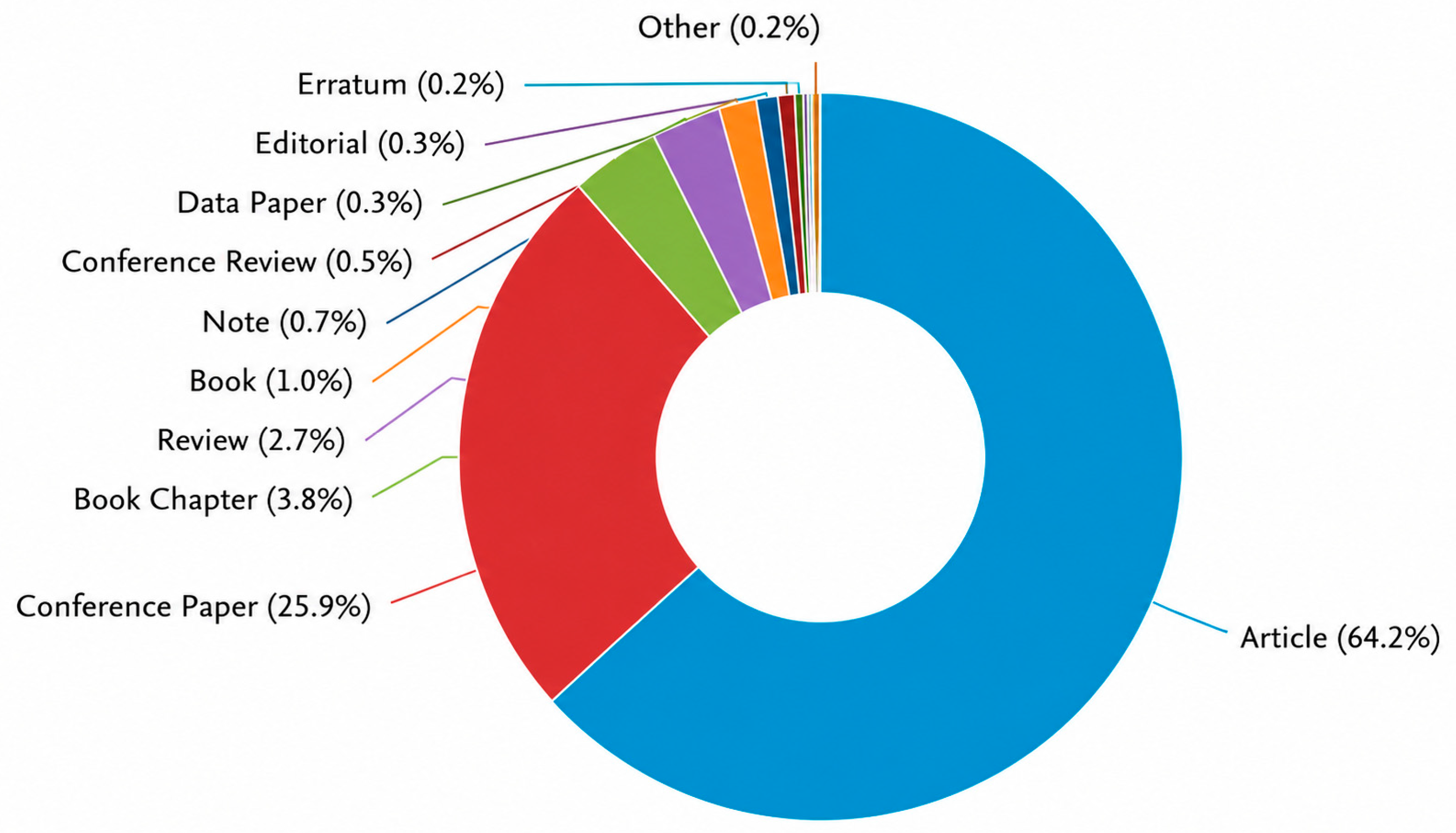
Regarding document typology, peer-reviewed scientific articles constitute the majority of identified publications (
Figure 14). This predominance suggests that the field has achieved a certain level of academic legitimacy, moving beyond technical reports or grey literature. However, ProQuest reveals a more significant presence of non-indexed documents, such as theses, institutional reports or conference communications, indicating that an important part of the debate on landscape observatories also circulates outside dominant scientific journals.
The structure of authorship and scientific production networks offers an equally revealing picture. A relatively small number of authors concentrates a substantial part of the production. This phenomenon is common in young scientific fields, where a limited number of pioneering groups, often associated with leading institutions, establish initial conceptual frameworks and generate recurring references [
53]. In the case of landscape observatories, these groups are mainly located in France, Italy, Switzerland and Spain, with direct connections to public planning institutions and institutionalised observatories [
43,
50,
54].
This pattern of authorship concentration gives rise to two complementary dynamics. On the one hand, it favours conceptual consolidation, as it facilitates the dissemination of clear and replicable models (for example, the aforementioned LABES model or the Landscape Observatories of Catalonia or Andalusia). On the other hand, it may generate risks of homogenisation, whereby a limited number of approaches dominates the academic debate, restricting the incorporation of perspectives from other regions or disciplines. The scarce presence of Latin American, African or Asian authors in the analysed databases reinforces this observation.
Finally, it should be noted that this thematic and authorship structure is directly related to the current stage of maturation of the field. Thematic dispersion, journal fragmentation and authorship concentration are typical characteristics of emerging fields that are in a phase of expansion but still lack robust academic institutionalisation. In this sense, the future development of research on landscape observatories will depend on its capacity to articulate international networks, promote diversity of approaches and consolidate shared methodological frameworks.
Beyond the bibliometric patterns discussed above, the qualitative review also identified a series of recurring institutional models and functional orientations. Although these dimensions could not be quantified consistently across all publications, they complement the bibliometric findings by synthesising how landscape observatories have been conceptualised and implemented in the literature.
Table 1 summarises these principal functions and institutional models.
The literature-based synthesis presented above provides the conceptual context for examining the operational characteristics of landscape observatories. The following section therefore analyses the original international database compiled for this study.
3.4. Comparative Characteristics of the International Database
The original international database comprising 188 landscape observatories and related initiatives provides a complementary empirical perspective on the organisational and methodological diversity of existing initiatives. Whereas the preceding sections examined how landscape observatories have been addressed in the scientific literature, the following analysis explores their geographical distribution, operational scales, institutional functions and methodological orientations in practice (
Figure 1).
As summarised in
Table 2, regional observatories constitute the predominant territorial scale, representing approximately half of the initiatives included in the database (50.0%), whereas local (22.3%) and national observatories (20.7%) account for a smaller but still substantial proportion. International or transboundary initiatives remain comparatively limited (7.0%). This distribution is consistent with the governance model promoted by the European Landscape Convention, where regional administrations have frequently acted as the principal institutional framework for landscape observation and monitoring.
The analysis also reveals that landscape observatories rarely pursue a single institutional objective. Long-term observation and monitoring represent the most widespread function, being explicitly identified in almost four out of every five initiatives (77.8%). Nevertheless, planning support is also highly represented (50.0%), while public participation (39.2%), knowledge exchange (34.7%) and awareness-raising activities (30.7%) appear as recurrent complementary functions. These results reinforce the interpretation developed throughout the bibliometric review that landscape observatories increasingly operate as interfaces connecting scientific knowledge, territorial governance and society.
Methodological diversity constitutes another defining characteristic of the compiled initiatives. GIS and remote sensing represent the most frequently adopted analytical approach (58.0%), particularly among regional and national observatories responsible for systematic territorial monitoring. Landscape indicators are also widely employed (47.1%), whereas repeat photography remains an important methodological component (42.0%), especially in observatories focused on long-term landscape dynamics and visual change. Participatory approaches are incorporated by more than one-third of the initiatives (38.5%), confirming the growing importance of stakeholder engagement alongside conventional monitoring techniques [
55]. By contrast, citizen science is still comparatively uncommon (13.8%), suggesting that public participation continues to rely predominantly on consultation, workshops and collaborative interpretation rather than on large-scale citizen-generated datasets.
Overall, the comparative database confirms several of the trends previously identified through the bibliometric analysis. The predominance of regional governance structures, the coexistence of technical and participatory methodologies, and the multifunctional nature of landscape observatories consistently emerge across both sources of evidence. At the same time, the marked diversity of institutional objectives and methodological configurations illustrates that landscape observatories continue to evolve through context-specific adaptations rather than according to a fully standardised international model. This diversity represents one of the principal strengths of the concept, while simultaneously highlighting the need for greater methodological interoperability and comparative evaluation frameworks.
3.5. General Discussion: Patterns, Gaps and Challenges in Research
The combined evidence obtained from the systematic review, bibliometric analysis and comparative database of landscape observatories identifies the field as emerging but progressively consolidating. Taken together, the bibliometric patterns, qualitative synthesis and comparative analysis of existing observatories reveal a set of consistent trends, including a strong geographical concentration, sustained temporal growth, marked disciplinary diversity and uneven institutional development. Rather than representing independent findings, these patterns collectively help explain both the current strengths of landscape observatories and the principal challenges that still limit their consolidation as international instruments of territorial governance.
A first observation emerging from both the bibliometric analysis and the comparative assessment of existing observatories concerns the clear geographical and temporal concentration of landscape observatory development. As shown in
Section 3.1 and
Section 3.2, publications have increased significantly since the mid-2000s, with a strong European epicentre. This temporal evolution closely overlaps with the institutional and normative diffusion of landscape policies in Europe following the entry into force of the European Landscape Convention in 2000, which provided a legal and political framework encouraging the creation of landscape observatories. Consequently, the bibliometric trends observed in this study confirm what several authors have previously suggested: landscape observatories should not be understood merely as technical devices for monitoring landscape change, but also as political and governance instruments whose emergence depends to a large extent on favourable institutional contexts [
8,
16,
43,
50].
This interpretation is also consistent with the successive implementation documents and policy guidance developed by the Council of Europe following the adoption of the European Landscape Convention. These documents progressively reinforced the role of landscape observatories as long-term mechanisms for monitoring landscape change, facilitating knowledge exchange and supporting participatory landscape governance. Consequently, the temporal evolution identified in the bibliometric analysis should not be interpreted simply as an increase in scientific production, but also as the reflection of a broader process of institutional consolidation promoted through European landscape policy.
This European leadership has generated both opportunities and limitations. On the one hand, it has enabled the development of consolidated institutional models, such as the Swiss and Spanish observatories discussed throughout the manuscript, demonstrating the technical and administrative feasibility of maintaining long-term landscape observation systems. On the other hand, the geographical distribution identified in the present review reveals a clear asymmetry, with Latin America, Africa and Asia remaining only marginally represented in indexed scientific production. As already noted in
Section 3.2, this pattern should not necessarily be interpreted as an absence of landscape-related initiatives but rather as evidence of unequal institutional development and uneven international visibility. The knowledge currently available therefore reflects only part of the diversity of landscapes, governance contexts and institutional experiences existing worldwide [
20,
27,
43,
50]. From this perspective, expanding the geographical scope of future research appears essential for overcoming the current European-centred development of the field.
A second major pattern concerns the pronounced interdisciplinarity identified through the analysis of research areas, document typologies and scientific journals. Publications are distributed across geography, landscape ecology, architecture, urban planning, environmental sciences, art history and cultural studies, confirming that landscape observatories have evolved into genuinely interdisciplinary platforms rather than remaining specialised monitoring programmes. This diversity constitutes one of the principal strengths of the concept because it reflects the hybrid nature of landscape itself, combining ecological, material, social, cultural and political dimensions [
34]. However, the bibliometric evidence also demonstrates that such disciplinary diversity has not yet been accompanied by equivalent methodological integration. As discussed in
Section 3.3, the absence of shared indicators, common protocols or comparable analytical frameworks continues to hinder systematic comparison among observatories operating in different territorial and institutional contexts [
16,
36]. The comparative database compiled in this study reinforces this conclusion by showing that, despite considerable methodological diversity among existing observatories, relatively few initiatives employ comparable monitoring protocols or interoperable indicator systems. The need for interoperable monitoring frameworks has likewise been highlighted in the Council of Europe review on integrated landscape monitoring approaches [
53].
Interdisciplinarity has therefore functioned as a driver of conceptual expansion, but not yet as a mechanism for systematic integration. While some publications prioritise technical approaches based on GIS, remote sensing and ecological metrics, others focus primarily on perceptual, participatory and cultural dimensions [
50]. This fragmentation reproduces longstanding debates within landscape research concerning the balance between objective and subjective approaches and reinforces the relevance of hybrid observation models, such as the Swiss LABES programme, which successfully combines biophysical indicators with social perception [
52]. Rather than reducing disciplinary diversity, future methodological developments should therefore seek to improve comparability while preserving the flexibility that currently characterises landscape observatories.
The bibliometric analysis also reveals another characteristic typical of scientific fields that are still undergoing consolidation: the dispersion of publications across numerous journals, together with the concentration of scientific production within a relatively limited number of research groups. This structure suggests that pioneering institutions have played a decisive role in establishing the conceptual foundations of landscape observatories and disseminating successful operational models. Although this concentration has contributed positively to the initial coherence of the field, it may also generate a homogenising effect that limits the incorporation of perspectives originating in different geographical and institutional contexts. The relatively limited participation of researchers from Latin America, Africa and Asia identified in this review reinforces this interpretation and highlights the importance of expanding international collaboration networks and promoting greater geographical diversity in future research.
A fourth issue emerging from both the literature and the comparative database concerns the relationship between scientific production and institutional practice. Although the analysed publications provide detailed descriptions of conceptual frameworks, organisational models and methodological approaches, comparatively few studies attempt to evaluate the real influence of landscape observatories on territorial planning, environmental policies or landscape management [
16,
17]. This gap, already identified in previous research, is reinforced by the combined evidence obtained from the reviewed literature and the comparative database, both of which indicate that relatively few observatories have been evaluated in terms of their long-term policy influence or governance effectiveness. Consequently, one of the principal priorities for future investigations should be the development of evaluation frameworks capable of measuring institutional effectiveness, policy influence and governance outcomes through comparable empirical indicators rather than descriptive accounts alone. At this point, it is worth emphasising that landscape observatories should not be understood solely as diagnostic tools, but as integrative devices capable of articulating scientific knowledge, social perception and decision-making processes [
7].
Overall, the combined evidence presented throughout this study indicates that landscape observatories have progressed beyond their initial experimental phase and are gradually becoming recognised components of contemporary landscape governance. Nevertheless, the persistence of geographical concentration, methodological fragmentation and limited evaluation of institutional impacts demonstrates that the field has not yet reached full scientific maturity. As previously suggested, future development should therefore focus on expanding geographical implementation and diversifying scientific perspectives; developing methodological frameworks capable of integrating biophysical and social dimensions; systematically evaluating institutional and territorial impacts; promoting international collaboration and data interoperability; and consolidating a shared conceptual language that strengthens the role of landscape observatories within planning and territorial governance policies.
In summary, the combined findings from the systematic review, bibliometric analysis and comparative assessment of existing observatories support the view that landscape observatories constitute a strategic field for contemporary territorial governance because they combine empirical observation, cultural interpretation and social participation. However, their future consolidation will depend on their capacity to transcend the current European-centred development of the field, overcome methodological fragmentation and demonstrate their practical contribution to territorial decision-making in increasingly complex environmental, urban and social contexts.
3.6. Recommendations
Based on the results obtained and on the comparative analysis of the three databases, there is a clear need to strengthen the scientific and institutional development of landscape observatories through a set of guidelines aimed at consolidating the field and expanding its impact on territorial governance. The detected trends reveal sustained growth and notable disciplinary diversity, but also expose methodological gaps, geographical asymmetries and shortcomings in the evaluation of outcomes.
First, the importance of broadening the geographical and cultural base of the concept becomes evident. The strong concentration of publications and experiences in Europe shows that the initial impetus of the model has been closely linked to specific normative frameworks, such as the ELC, and to consolidated administrative structures. However, the limited presence of research from Latin America, Africa or Asia suggests that the concept of the landscape observatory has not yet been widely appropriated or adapted in extra-European contexts. This absence restricts the possibility of constructing a truly global approach and of enriching the concept with diverse cultural and ecological perspectives. Promoting the creation of interregional networks, fostering the translation and circulation of knowledge, and facilitating methodological transfer between regions therefore emerge as essential strategies to democratise the development of the field and reduce its current Eurocentric concentration [
16,
36,
39].
Second, the review highlights the need to move towards greater methodological coherence, without losing the conceptual diversity that characterises landscape observatories. Analysis of the publications reveals the coexistence of very different approaches, ranging from quantitative methodologies based on remote sensing, environmental indicators and geographic information systems, to qualitative and participatory approaches focused on perception, visual culture or governance. This plurality represents an undeniable richness, but also a source of fragmentation. Consolidation of the field will require the definition of reference frameworks that integrate biophysical and cultural dimensions through common indicators, comparable protocols and interoperable data structures. Experiences from initiatives such as OAPA, OPC or LABES demonstrate that it is possible to combine physical and perceptual variables within a single observation system [
2,
7,
39]. Similarly, the participatory model of the Landscape Observatory of Sierra Nevada [
10] highlights the relevance of incorporating citizens into the interpretation and valuation of landscapes [
52]. Taking these methodological frameworks as references and adapting them to different contexts could contribute to greater international coherence and comparability.
At the same time, there is a clear need to systematically evaluate the impact of observatories on public policies and territorial management. Although search results show an increase in studies describing structures and methodologies, there are very few works that analyse the concrete effects of these platforms on planning or decision-making processes. Observatories, therefore, risk becoming consolidated as spaces of observation without an effective connection to public action. Incorporating impact indicators (such as influence on territorial plans, integration of results into regulations or the generation of institutional change) would make it possible to assess their real effectiveness and justify their continuity. As pointed out by Ternell et al. and Galán Vivas [
21,
22], the transition from observation to effective governance requires linking observatory outputs to verifiable political processes.
Likewise, strengthening the institutional and financial sustainability of existing observatories is a priority. Many depend on temporary programmes or on the political will of regional governments, which makes them vulnerable to political or budgetary changes. Ensuring long-term continuity requires diversified funding models, the creation of consortia among universities, public administrations and private entities, and the establishment of stable digital infrastructures that guarantee data preservation and open access. Sustainability should be understood not only in economic terms, but also as a matter of institutional resilience, ensuring the capacity of observatories to adapt to changing contexts and new knowledge demands. Recent experiences from local landscape observatories also demonstrate that governance continuity depends heavily on stable institutional cooperation and long-term stakeholder engagement [
44].
Finally, it is necessary to enhance the collaborative and interdisciplinary dimension of observatories. The results show that, despite the theoretically transversal nature of the concept, scientific production remains segmented by disciplines and limited to specific academic communities. Observatories could become genuine spaces of knowledge co-production if networks among researchers, technicians, planners, local communities and citizens are strengthened. The incorporation of digital technologies, participatory mapping tools and citizen science methodologies offers a promising pathway to build more open, inclusive and socially connected observatories.
Overall, the evidence analysed suggests that the future of the field will depend on its ability to articulate three essential dimensions: geographical diversity, enabling the extension of the model to different contexts; methodological integration, unifying approaches without impoverishing disciplinary complexity; and institutional effectiveness, ensuring the continuity and political relevance of observatories. Achieving this balance does not imply homogenising practices, but rather building a shared culture of landscape observation in which plurality is compatible with scientific cooperation and with democratic territorial governance.
Future research should also examine the institutional ecology of landscape observatories, including the relative roles of universities, governmental bodies, research institutes, NGOs and other organisations in shaping governance structures, long-term sustainability and policy influence. Such analyses would complement existing bibliometric approaches by providing a deeper understanding of the organisational arrangements underpinning landscape observatories.
4. Conclusions
The principal contribution of this study lies in combining a PRISMA-guided systematic review and bibliometric analysis of the scientific literature with an original international database of 188 landscape observatories and related initiatives. This integrated approach makes it possible to examine the field from both scientific and institutional perspectives, providing a more comprehensive understanding of its current development than either source of evidence could offer independently. The results show that landscape observatories have evolved over the past two decades from relatively isolated initiatives into an emerging reference framework at the intersection of scientific research, territorial planning and environmental governance. This evolution is closely associated with the progressive implementation of the European Landscape Convention and with pioneering institutional experiences such as the Observatorio y Archivo de los Paisajes de Andalucía, the Observatori del Paisatge de Catalunya and LABES. Nevertheless, the limited representation of other world regions demonstrates that the development of the field remains markedly Eurocentric and highlights the need for broader geographical and cultural expansion.
The combined evidence synthesised in this study indicates that landscape observatories are grounded in a diverse epistemological base, in which technical, ecological, participatory and cultural approaches coexist. This plurality is a strength, enabling landscape to be addressed from multiple perspectives, but it also constitutes a challenge in progressing towards greater methodological coherence and international comparability. The articulation of shared frameworks without renouncing diversity of approaches represents one of the central challenges for their scientific and operational consolidation. At the same time, the limited attention paid to the real impact of observatories on territorial decision-making reveals the need to strengthen the links between observation, governance and public action. The present review should also be interpreted in light of certain methodological limitations. The bibliographic search was completed using records available up to 2023 and therefore does not include publications released thereafter. Furthermore, although Web of Science, Scopus and ProQuest provide broad international coverage and constitute well-established sources for systematic reviews, their indexing policies tend to favour English-language and internationally visible publications. Consequently, scientific contributions published in other languages or in regional journals may be underrepresented, which could partially reinforce the geographical asymmetries identified throughout this study. Future updates incorporating more recent publications and complementary regional databases would contribute to a more comprehensive understanding of the global development of landscape observatories.
In summary, the future of landscape observatories will depend on their capacity to overcome current fragmentation and to project themselves as global instruments of knowledge and territorial management. The evidence synthesised in this review suggests that achieving this objective will require expanding their geographical implementation, integrating diverse methodologies within shared structures and strengthening their institutional effectiveness. Observatories have the potential to become strategic nodes of landscape governance if they succeed in establishing a stable link between scientific production, social participation and public decision-making. Their consolidation will not be solely technical, but also political and cultural, representing a substantial advance in the way societies observe, interpret and manage their landscapes. These conclusions derive from the combined interpretation of the bibliometric evidence and the qualitative synthesis of the reviewed literature and should therefore be understood as evidence-based recommendations rather than direct evaluations of the performance of individual landscape observatories.