


Abstract
Over the past two decades, Citizen Science (CS) has experienced rapid growth, driven by technological advancements and the rise of digital platforms. This work examines the necessity for standardization in Citizen Science data management and discusses how existing data standards can enhance the impact of citizen-generated data. CS standardization ensures data quality, comparability, reusability, and interoperability, making data suitable for contributing to the Marine Strategy Framework Directive (MSFD) and the United Nations Sustainable Development Goals (SDGs). This paper examined 130 Citizen Science publications and found that most collected data referred to the MSFD Descriptor 1 (Biodiversity—44.96%) and Descriptor 10 (Marine Litter—20.93%), followed by the alien species distribution (D2—11.63%), hydrography (D7—6.20%), eutrophication (D5—6.20%), and marine pollution (D8—3.10%). Analysis of 108 publications on SDG alignment revealed that the majority (35.58%) focused on reducing marine pollution. This paper reviews the best practices for effective Citizen Science data management, including standards for data structures, content, values, and exchange. Based on this review, Darwin Core, Ecological Metadata Language (EML), and the OGC SensorThings API appear to be the most suitable standards for MSFD-relevant CS data. Therefore, policymakers could enable the formal integration of standardized CS datasets into MSFD monitoring workflows.
1. Introduction
The umbrella term “Citizen Science” includes a wide range of participatory research practices that actively engage societal actors and members of the public in knowledge co-production. Citizen Science enables participants outside academia to contribute at various stages of research and innovation through data collection, storage, analysis, and sharing, as well as through further intellectual efforts, tools, and resources. Citizen Science is a rapidly growing field that contributes to the democratization of science, enabling volunteers to participate in environmental monitoring, biodiversity conservation, astronomy, and numerous other disciplines. However, the Citizen Science landscape remains fragmented, with multiple projects and initiatives demonstrating success at a local level but limited ability to scale up to the national or EU level or to contribute to official monitoring efforts. This is due to the lack of standardized methodologies for data collection, analysis, storage, and interoperability. There is, therefore, a crucial need for standardized data management. In parallel, as the implementation of marine legislation requires extensive datasets collected over long periods and large areas, Citizen Science could support policy objectives by increasing the acquisition and cost-effective processing of environmental data. Moreover, Citizen Science would improve policy acceptance by empowering communities and involving them in research that can drive policy change [1].
EU key policy instruments, like the Water Framework Directive (WFD), the Birds and Habitats Directives, and the Marine Strategy Framework Directive (MSFD), require Member States to collect high-quality data on various parameters from water bodies and marine regions. Citizen Science and emerging data sources, such as remote sensing and mobile phone records, could provide an innovative approach to enhance and complement official statistics. This direction is contributed to by collecting standardized, high-quality data to assess the state of marine and freshwater environments and track progress toward environmental sustainability goals. The scope of the present work covers both freshwater and marine realms and thus shifts between MSFD as the primary analytical lens, and WFD and SDGs as complementary frameworks, to cover the full range of aquatic CS EU governance.
The MSFD aims to achieve “Good Environmental Status” for all European seas by requiring comprehensive data on biodiversity, pollution levels, and marine ecosystems [2]. Citizen Science can play a critical role in this process by providing valuable data from coastlines and oceans. However, for this data to be accepted and integrated into official monitoring and reporting systems, it must comply with the existing MSFD’s data standards and protocols. Standardization ensures that the data collected by volunteers is consistent, reliable, and interoperable with governmental databases, facilitating its use in marine policy evaluations.
Similarly, the WFD aims to achieve good status for all European water bodies. To comply with the WFD, Citizen Science data on water quality must be collected using standardized methods in alignment with governmental and scientific monitoring practices. Standardization enables the aggregation of data from various Citizen Science projects and initiatives, thereby improving overall assessments of water bodies and helping policymakers meet the WFD’s goals for cleaner, healthier water systems.
Furthermore, the UN Sustainable Development Goals (SDGs), particularly Goal 14 (Life Below Water) and Goal 6 (Clean Water and Sanitation), call for improved monitoring of environmental health [3,4]. Citizen Science can significantly contribute to tracking progress on these goals by providing large datasets on marine and freshwater conditions [5]. Standardizing this data ensures it meets the quality requirements for international reporting, enabling it to inform global progress toward environmental sustainability.
Beyond the SDGs, frameworks such as the Paris Agreement [6], the Sendai Framework for Disaster Risk Reduction [7], the New Urban Agenda [8], and the post-2020 Global Biodiversity Framework [9] also require improved monitoring and implementation, areas where Citizen Science could be beneficial. For instance, Danielsen et al. [10] demonstrated that Citizen Science data could inform 63% of the 186 indicators across 12 multilateral environmental agreements.
Therefore, aligning Citizen Science data with international frameworks such as the MSFD, WFD, and SDGs through standardization is essential to ensure its utility for policy and compliance, and to achieve long-term environmental goals. Standardizing data management methods used by volunteers ensures that the data they collect is high-quality, reusable, and interoperable across different platforms and projects. Such data could be used, under specific rules and conditions, to implement the WFD and MSFD. Without standardization, Citizen Science data risks fragmentation, inconsistency, and difficulty in integration into broader scientific research. This work will examine the necessity for data standardization in Citizen Science and discuss how existing data standards can enhance the usability and impact of citizen-generated data.
This work is part of the OTTERS project on “Social Transformation for Water Stewardship through Scaling Up Citizen Science”, which aims to promote successful water-related Citizen Science initiatives in the marine and freshwater domains, demonstrate their capacity in participatory environmental monitoring research, improve data quality, and standardize data and metadata management to ensure interoperability. Therefore, an extensive assessment of data accuracy in Citizen Science is required, covering the adopted methodology, instrumentation used, analysis methods, and data and metadata harmonization [11,12,13]. This approach is necessary to facilitate connections between existing and future Citizen Science projects and initiatives and the main EU data repositories, such as EMODnet, CMEMS, EDITO, and others.
This paper reviews Citizen Science contributions to MSFD and SDGs, examines data standardization practices and standards, and discusses their implications for policy uptake.
2. Can Citizen Science Complement Official Scientific Data Sources to Improve MSFD and SDG Monitoring?
Citizen Science (CS) has the potential to complement and supplement official scientific data sources in marine monitoring, thus aiding the implementation of MSFD. CS enables large-scale, spatiotemporal monitoring [14] and the detection of long-term ecosystem changes [15]. However, in order to scale observations into proper monitoring, validation, metadata completeness, and calibration should be implemented, producing data and metadata in accordance with the scientific methodologies and standards of MSFD databases. Under these prerequisites, CS could produce cost-effective, scalable data for scientific teams to assess the GES of marine ecosystems.
We collected and examined 130 CS scientific publications from curated libraries and databases, including Zooniverse and EU-Citizen Science (EU-CS), SciStarter, and U.S. government repositories, after a structured processing and selection phase. We utilized a combination of core keywords (e.g., ‘Citizen Science’, ‘Participatory Monitoring’) paired with specific marine vectors (e.g., ‘MSFD’, ‘Marine Litter’, ‘Jellyfish’, ‘Biodiversity’, ‘Invasive Species’, and other keywords related to MSFD Descriptors and SDG indicators). Our search criteria prioritized peer-reviewed publications but also included authoritative grey literature to capture the full scope of Citizen Science implementation. These publications were assessed for their capacity to support the implementation of various Marine Strategy Framework Directive (MSFD) Descriptors. Publications were categorized according to their relevance to each Descriptor. We have found that most works refer to CS concerning D1 (Biodiversity—44.96%) and D10 (Marine Litter—20.93%) (Figure 1). This probably reflects the high suitability of direct visual observations for CS, which require minimal equipment and align strongly with public interest in both nature and anthropogenic threats to its integrity. The spatial distribution of alien species (D2—11.63%), the hydrographic conditions (D7—6.20%), eutrophication (D5—6.20%), and marine water pollution (D8—3.10%) are topics covered by a limited number of publications. It is apparent that, with the proper motivation, management, and tools, the CS approach could be extended to support the implementation of the MSFD across other descriptors.
Figure 1.
CS publications collecting data with potential contribution to MSFD Descriptors.
Most publications (17.8%) collect data following the GES Criterion D1C4, which addresses the spatial distribution and patterns of species and ensures they are representative of the physiographic, geographic, and climatic conditions of the area. This is followed by GES Criterion D10C1, relevant to 13.1% of the total publications list, which concerns the composition, quantity, and spatial distribution of litter on the coastline, at the surface of the water column, and at the seabed, at levels that do not cause damage to the coastal and marine environment. Finally, 10.1% of the works are related to the implementation of monitoring for the GES Criterion D1C1, which refers to mortality rates per species from by-catch. The remaining criteria each account for smaller proportions of the reviewed publications, as illustrated in Figure 2. This ordering reflects both the dominance of biodiversity-related observations in CS activities and the growing public engagement with marine litter issues, while also revealing the relatively limited CS coverage of other MSFD criteria, which represents an important gap for future CS initiatives.
Figure 2.
Scientific publications collecting marine environmental data that could potentially aid the implementation of MSFD criteria. Each circle represents one MSFD criterion, with the circle’s size proportional to the percentage of reviewed publications whose data collection could contribute to monitoring that criterion. Color coding corresponds to the MSFD Descriptor groupings used in Figure 1.
Moreover, we analyzed 108 publications, comprising peer-reviewed journal articles and authoritative grey literature, including reports from international organizations and government repositories, to evaluate their contributions to the implementation of the Sustainable Development Goals (SDGs) (Table 1). Our findings reveal that a significant portion of the studies focus on SDG 14 (Life Below Water), particularly on marine pollution, with 37 publications (35.58%) addressing its reduction (14.1.1). Additionally, SDG 6 (Clean Water and Sanitation) is represented by 14 publications (13.46%) specifically related to improving water quality (6.3.2) and international cooperation in water management (6.A.1). Furthermore, we found five publications (4.81%) relevant to SDG 17 (Partnerships for the Goals), focused on enhancing global partnerships, and eight publications (7.69%) related to improving data availability (Table 1).
Table 1.
CS Publications Related to the Sustainable Development Goals (SDGs).
Based on the above findings, it is evident that marine pollution, particularly plastic pollution, already attracts a disproportionately large share of CS research attention relative to other marine environmental issues. While the concentration of publications around SDG 14 (Life Below Water), and specifically around marine pollution reduction (SDG Target 14.1), reflects both the high public salience of plastic pollution and the relative accessibility of visual litter monitoring methods for citizen scientists, it also reveals a significant imbalance in CS coverage across SDG targets. Notably, other critical SDG targets, including those related to the sustainable management of marine and coastal ecosystems (SDG 14.2), clean water quality (SDG 6.3.2), and water-related ecosystem protection (SDG 6.6.1), are represented by comparatively few publications. These gaps indicate that future CS initiatives and the policies that support them should prioritize broadening thematic coverage beyond marine litter, directing effort and resources toward underrepresented descriptors and targets where citizen-generated data could make a substantial contribution but currently remains limited.
Marine pollution, particularly plastic pollution, is highlighted as a global concern under SDG 14, which aims to “conserve and sustainably use the oceans, seas, and marine resources for sustainable development” [16]. Specifically, SDG Target 14.1 aims to “prevent and significantly reduce marine debris” from land-based activities, with progress tracked by an indicator (SDG Indicator 14.1.1b) measuring “plastic debris density” in the marine environment [17]. These indicators could help assess a country’s progress in reducing marine plastic pollution and evaluate the effectiveness of management efforts [18]. The SDGs, along with their targets and indicators, serve as a framework for coordinating actions to address marine pollution across governments, research institutions, the private sector, and society [19].
3. Best Practices in CS Monitoring Contributing to MSFD
The following case studies illustrate successful applications of Citizen Science in marine monitoring that contribute to MSFD implementation. For each example, the key features that contributed to its success are identified, forming the basis for a set of best practice recommendations presented at the end of this section.
Data collection for the assessment of the MedSens index was developed to bridge the gap between Citizen Science and coastal management [20]. This index integrates Citizen Science data into an institutional monitoring program tailored for specific sensitivities to the pressures indicated by the MSFD. Trained snorkelers, freedivers, and volunteer scuba divers collect data on species distribution in the Tuscan Archipelago National Park. The open data on distributions and abundances collected by trained volunteers using the Reef Check Mediterranean Underwater Coastal Environment Monitoring (RCMed U-CEM) protocol subsequently helps decision-makers identify the main pressures acting in these habitats, as required by the MSFD. Evidently, CS supports the implementation of appropriate marine biodiversity conservation measures and improves the communication of the results to the broad audience. The data collected from this activity, focusing on taxa such as algae, invertebrates, and fish, contribute to implementing the MSFD in D1 (biodiversity), D2 (non-indigenous species), and D6 (Seafloor integrity). The monitoring protocol’s simplicity, which reduced any technical barriers to volunteer participation; the structured volunteer training program, which ensured data quality and consistency; and the strong institutional anchoring within an official national park monitoring framework contributed to MedSens benchmark, providing the citizen-generated data with direct policy relevance and ensuring its integration into official monitoring workflows.
Another example is the implementation of fish assemblage monitoring (D1—Biodiversity) using underwater visual census (UVC) surveys and the analysis of eDNA samples, i.e., the DNA extracted from environmental samples, such as seawater, with the help of trained divers [21]. In addition, the mobile app “Dive Reporter” was developed and used to compile information on the frequency and abundance of marine taxa by recreational scuba divers in Madeira [22]. Both initiatives demonstrate the value of leveraging existing communities of skilled volunteers, whose prior expertise reduces training requirements and increases the reliability of collected data. The use of a dedicated mobile application in the Dive Reporter case further illustrates how purpose-built digital tools can standardize data entry at the point of collection, reducing transcription errors and improving metadata completeness.
Local fishermen contributed to the study of pufferfish species in the Strait of Sicily (Lampedusa Island, Italy), playing an essential role in the monitoring of potentially toxic marine species (D2—Non-indigenous Species) [23]. In a similar context, the role of Citizen Science was conceived as of paramount importance by the Mediterranean Commission (CIESM) [24], since programs like Jellywatch and other Jellyfish Observation Initiatives (JOIs) have proved to be a useful tool to monitor both the spreading of gelatinous NIS (in line with Descriptor 2) and the occurrence of local blooms of native species [25,26,27]. These examples highlight the importance of engaging communities with direct, place-based knowledge of the marine environment, such as local fishermen and coastal residents, to extend spatial and temporal monitoring coverage beyond what is achievable through scientific surveys alone. The integration of local ecological knowledge with standardized reporting protocols is the key best practice emerging from these initiatives.
Further, projects such as the MECO Project (Marine Ecosystems Community Online, https://www.mecoproject.org/ (accessed on 21 January 2026) and the Secchi Disk Project (http://www.secchidisk.org/ (accessed on 23 January 2026) have provided significant opportunities for citizens to contribute to marine monitoring. The MECO Project focuses on building a collaborative community dedicated to protecting marine species, including elasmobranchs, sharks, rays, and skates, through data collection, awareness-raising, and sustainable practices. It encourages citizen scientists to contribute data on marine ecosystems, supporting long-term monitoring and conservation efforts. Similarly, the Secchi Disk Project leverages the Secchi Disk app, enabling users to measure water transparency using a simple Secchi disk. This data aids in assessing water quality and eutrophication levels, contributing valuable insights towards achieving the Marine Strategy Framework Directive (MSFD) descriptors, particularly D5 (Eutrophication) and D7 (Hydrographic Conditions). The accessibility of the Secchi disk as a monitoring tool, requiring minimal training and negligible cost, exemplifies protocol simplicity and low resource requirements as critical enablers of broad volunteer participation and sustained long-term data collection.
Specialized marine litter projects, such as “Plastic Pirates,” underscore the importance of standardizing data collection and analysis to ensure that citizen-generated data effectively informs policy and conservation efforts. By establishing clear protocols, these projects contribute to growing evidence on the impacts of plastic pollution and the effectiveness of mitigation efforts, while also demonstrating that standardization need not come at the expense of accessibility when protocols are designed with non-specialist volunteers in mind.
4. Adoption of CS Data Management Practices
The heterogeneity of data-sharing practices and the adoption of interoperability standards in Citizen Science initiatives present significant challenges and opportunities for advancing the potential of community-driven research. Citizen Science projects can generate large volumes of valuable data across various domains; however, the diversity of participants, methodologies, and objectives often leads to fragmented approaches to data management and sharing. To address this limitation, a strategic adoption of data standards is needed to harmonize data collection, representation, and exchange across Citizen Science initiatives.
Data standardization and data harmonization are two related but distinct concepts. Standardization refers to the adoption of common, fixed protocols, formats, and vocabularies across all projects. This approach ensures that data is collected and recorded in an identical manner. Harmonization, by contrast, refers to the process of making datasets from diverse sources sufficiently compatible for aggregation and comparative analysis. Therefore, while standardization represents the ideal endpoint for CS data integration into official monitoring frameworks, such as the MSFD, harmonization may in practice be a more achievable and inclusive goal for a significant proportion of CS initiatives, particularly those operating at local scales with limited training, time, and resources.
This distinction has important practical implications for the design of CS data management frameworks. Citizen scientists frequently work under constraints: limited equipment, variable levels of training, restricted sampling windows; thus, the opportunistic nature of many observations could make strict adherence to fixed, standardized protocols difficult or impossible. Imposing full standardization as a prerequisite for including CS data in official datasets risks excluding large volumes of potentially valuable observations that, although not collected under identical conditions, still contain information that could meaningfully contribute to MSFD monitoring if appropriately contextualized and quality assessed.
A tiered framework could offer a more pragmatic approach, distinguishing between minimum data requirements for inclusion in official datasets and recommended best-practice standards. Under such a framework, CS datasets could be eligible for integration into MSFD monitoring workflows, provided they meet a defined set of core requirements, such as sampling geographic location, date and time of observation, observer identity, and the target variable measured, while retaining flexibility in other aspects of metadata documentation, data format, and collection methodology. Projects that additionally comply with recognized standards such as Darwin Core, EML, or OGC SensorThings API would be flagged as meeting a higher tier of data quality, making them suitable for more direct integration into repositories such as EMODnet, GBIF, or OBIS without additional processing. This tiered harmonization approach would lower the barrier to data entry for CS initiatives operating under resource constraints, broadening the pool of citizen-generated data available for marine monitoring. It could further create a clear incentive structure for future CS projects to progressively improve their data management practices.
The Venn diagram illustrates the components of data and metadata standardization and effective data sharing, including data structure, data content, data exchange, and data values (Figure 3).
Figure 3.
Components for data standardization to achieve interoperability in Citizen Science.
4.1. Standards for Data Structures
Robust standards for data structures, such as Dublin Core, VRA Core, EAD, and MARC21, are foundational for determining how data is organized, represented, and interpreted [28]. Standards on data structures refer to the systematic ways of organizing and storing data to enable efficient access, management, and utilization of information. These standards are essential for creating comprehensive metadata frameworks. In practice, the main challenges to complying with these standards are related to the lack of resources, expertise, or training to fully implement rigorous metadata standards. Moreover, the lack of awareness of these standards represents a distinct barrier from resource or capacity constraints. While resource gaps can, in principle, be addressed through funding and technical support, awareness gaps require targeted outreach, communication strategies, and the integration of standard-compliant data entry into the design of CS platforms and mobile applications.
The principle of embedded standardization appears to be the most scalable approach to improving CS data quality across the diverse, fragmented landscape of marine CS initiatives. For example, using structured data entry forms that enforce required fields, controlled-vocabulary dropdown menus, or automatic coordinate capture, volunteers can contribute standardized data without explicitly understanding the underlying standards. Embedded standardization, sometimes referred to as “standardization by design”, removes the dependency on individual awareness or technical literacy as prerequisites for standard-compliant data collection.
To bridge these gaps effectively, it is therefore crucial to pursue a dual strategy, providing training, resources, and user-friendly tools and platforms for CS project designers wishing to implement standards explicitly, while simultaneously advocating for the integration of standard-compliant data structures into the mainstream CS platforms and applications through which the majority of citizen-generated marine data is collected.
4.2. Standards for Data Content
In addition to data structures, standards for data content play a pivotal role, referring to the specific information and attributes captured within datasets, as well as the standards that govern how this information is described, classified, and organized. Key standards such as RDA (Resource Description and Access), AACR2 (Anglo-American Cataloguing Rules, 2nd edition), CCO (Cataloging Cultural Objects), and DACS (Describing Archives: A Content Standard), adopted into data management practices, are crucial for promoting consistency, interoperability, and integrity across platforms. Cataloguing standards are significant for ensuring that data is documented consistently and made accessible in Citizen Science initiatives. A few examples of standards and guidelines specifically relevant to cataloguing in this context are:
- Data Documentation Initiative (DDI), supporting Citizen Science projects by providing clear instructions on how to catalogue and describe the data collected.
- Ecological Metadata Language (EML), designed for documenting ecological and environmental data, including variable descriptions, measurement units, and collection methods.
- Darwin Core, widely used for biodiversity data and essential in Citizen Science projects focused on species observation, provides a framework for cataloguing data contents related to organisms, including taxonomy, geographic locations, and occurrence records, ensuring that biodiversity data is standardized and interoperable.
- Bioschemas, a community-driven initiative offering specifications for biological data description, focusing on the semantic representation of data contents.
- Observations and Measurements (O&M) provide a standardized approach to documenting measurements and observations in environmental research, outlining how to catalog the contents of datasets, including the methods of measurement, units used, and associated metadata, ensuring that Citizen Science data is accurately represented.
4.3. Standards for Data Values
Standards for data values are equally important, as they ensure the consistency and accuracy of the recorded dataset. This category of standards encompasses controlled vocabularies such as LCSH (Library of Congress Subject Headings), AAT (Art and Architecture Thesaurus), TGN (Thesaurus of Geographic Names), DDC (Dewey Decimal Classification), LCC (Library of Congress Classification), and ISO 639-2 (Language Codes) [29]. These standards provide a common language that facilitates data interoperability by ensuring that the terms used to describe data are understood consistently across users [21]. In Citizen Science, ensuring that values such as species names, geographic locations, or language codes are recorded according to recognized standards is crucial for enabling large-scale data aggregation and analysis.
4.4. Standards for Data Exchange
Finally, standards for data exchange, such as ISO2709 (MARC) [30], XML, RDF, and JSON, are crucial for enabling the effective sharing and integration of data across systems and platforms [31]. These standards determine how data is formatted and packaged for exchange, ensuring its transmission between different software applications without losing information or meaning. In CS, where data are collected across diverse platforms, including mobile apps, online databases, and paper records, the need for consistent exchange formats is paramount. Using standardized data exchange formats such as JSON or RDF, CS initiatives can facilitate the integration of their data with other datasets, making it easier for researchers to access and analyze information from multiple sources.
While achieving this level of standardization is not without difficulties—particularly given the diverse and fragmented nature of CS initiatives—there is a clear path forward that involves resources, training and education, collaboration, and the development of user-friendly tools and protocols [21]. Ultimately, adopting data standards enhances Citizen Science’s ability to generate valuable scientific data and address complex, global challenges.
5. Current Efforts in CS Standardization
Through CS projects and initiatives, members of the public collect and analyze environmental samples and data using structured methodologies, employing easy-to-use portable sensors, smartphone apps, cameras, and other IoT technologies, and produce data shared with scientists’ databases [32,33]. Most marine CS projects in Europe focus on life sciences. For example, in the North Sea, 48% of all projects focus on “species”, 16% on “general biodiversity”, and 8% on “ecology” [34]. Among marine species, mammals, fish, birds, crustaceans, and jellyfish are typically the most active fields of research drawing on Citizen Science, with jellyfish projects widespread in Southern European Seas [1,27].
The diverse range of participants and methodologies involved in CS can lead to inconsistencies in data quality and reporting. To address these challenges, various organizations and initiatives are actively developing frameworks to promote consistency, interoperability, and reliable data collection. Several notable initiatives are paving the way for effective standardization in CS. One notable effort is spearheaded by UNESCO, which introduced the Ocean Data Standards to facilitate the reliable sharing of oceanographic data across global platforms. These standards enhance data quality while fostering international collaboration among researchers, governments, and citizen scientists, ultimately supporting informed decision-making in marine conservation.
Moreover, the Global Biodiversity Information Facility (GBIF) and the Ocean Biogeographic Information System (OBIS) play crucial roles in promoting standardization. They focus on improving data sharing and accessibility within the biodiversity community. GBIF emphasizes the importance of adopting standardized data formats and metadata to facilitate collaboration and enable the integration of citizen-generated data into global biodiversity databases. This effort enhances data quality and expands its applicability for addressing pressing environmental challenges.
In Europe, the European Citizen Science Association (ECSA) has also taken significant steps to promote best practices within the Citizen Science community. Through its guidelines and recommendations, ECSA encourages transparency and reproducibility in data collection and management. The association’s emphasis on standardized methodologies fosters trust and credibility in citizen-generated data, thereby increasing its value for scientific research and informed decision-making processes.
Moreover, the INSPIRE (Infrastructure for Spatial Information in Europe) initiative aims to achieve interoperability for spatial information using internationally recognized standards. INSPIRE, adopted by Directive 2007/2/EC, does not apply any proprietary models but uses the existing ISO 19100 [35] series of standards for geographic information and Open Geospatial Consortium (OGC) standards for data access and services. It also provides a framework for integrating data from Citizen Science projects, enabling observations and measurements made by citizens to be used in official spatial datasets and environmental monitoring. Interoperable network services for discovery, viewing, and downloading are implemented in accordance with OGC standards, including CSW, WMS, WFS, and WCS, and follow the INSPIRE technical guidelines.
In the United States, Citizen Science.gov serves as a vital platform for promoting Citizen Science across federal agencies. This initiative provides resources and toolkits for government employees to implement Citizen Science projects while adhering to established standards and practices. By fostering collaboration between scientists and the public, Citizen Sciencee.gov enhances the inclusivity and impact of scientific research.
In addition to these initiatives, the PPSR (Public Participation in Scientific Research) core emphasizes the need for shared values and practices that foster public involvement in scientific research. PPSR advocates integrating Citizen Science into formal research agendas, highlighting the importance of data integrity, ethical considerations, and community engagement.
Finally, the European Marine Observation and Data Network (EMODnet), an EU-funded initiative, compiles, processes, and makes available a wide array of datasets related to the marine environment. EMODnet consolidates these datasets into standardized formats, enabling researchers, policymakers, and stakeholders to access valuable information for marine management and conservation. It uses a robust set of metadata standards and controlled vocabularies to ensure data consistency, interoperability, and quality across its marine datasets, including the Common Data Index (CDI) format from SeaDataNet, which is based on the ISO 19115 [36] standard for geographic information, the NERC Vocabulary Server, and the SDN (SeaDataNet) vocabularies to standardize data terminology and harmonize metadata descriptions. Finally, for marine litter data, EMODnet integrates tools such as Mikado for CDI metadata generation, the NEMO tool for NetCDF file management, and the Marine Litter Manager, which generate EMODnet beach and seafloor data formats that help data providers create and manage compliant metadata and data records. These tools ensure that datasets meet the required quality standards before they are included in EMODnet’s data portals.
The initiatives reviewed above represent significant progress toward improving CS data standardization at both the European and global levels. Collectively, they demonstrate growing institutional recognition of the importance of standardized CS data for marine monitoring and policy implementation, and provide a range of frameworks, tools, and guidelines that CS projects can draw upon. However, several limitations in the current landscape of standardization efforts warrant attention. Many of these initiatives operate in parallel rather than in coordination. For example, GBIF promotes Darwin Core as a primary standard for biodiversity data, while EMODnet uses SeaDataNet CDI formats based on ISO 19115. These two frameworks are not directly interoperable without additional mapping effort. This fragmentation places the burden of reconciling different standards on individual CS projects, which frequently lack technical capacity. Furthermore, most existing standardization initiatives focus on data formats and vocabularies, while giving comparatively less attention to the standardization of data collection protocols and quality assurance procedures, the upstream stages of the data pipeline where many of the most consequential inconsistencies in CS data originate. A further limitation is the uneven geographic coverage of existing standardization efforts. While European initiatives such as INSPIRE, EMODnet, and ECSA provide relatively well-developed frameworks for CS projects operating within the EU, CS initiatives in other regions, such as the Mediterranean non-EU countries that are directly relevant to MSFD implementation in shared marine regions, may lack access to equivalent infrastructure and guidance.
To improve the coherence and effectiveness of current standardization efforts, greater coordination between existing initiatives is needed, with a particular focus on developing crosswalks and mapping tools that allow CS data compliant with one standard to be translated into other standard formats without manual intervention. Investment in upstream standardization would complement existing downstream data format standards and address some of the most persistent sources of inconsistency in CS datasets. Finally, extending the geographic reach of existing European standardization infrastructures to non-EU Mediterranean countries would strengthen the regional coherence of CS monitoring relevant to MSFD.
6. Existing Data and Metadata Standards
The challenge of achieving interoperability in Citizen Science is further compounded by the fact that many projects lack resources, leading to poor project design, or are led by scientists or amateur scientists who may not have the time, technical skills, or knowledge required to implement data standards effectively. This often results in a patchwork of data-sharing practices, where some projects adhere to rigorous standards, while others use ad hoc methods that are easier to implement but less effective for ensuring data quality and interoperability.
Data and metadata standards are crucial components in CS, providing a structured framework for collecting, managing, and sharing datasets. By establishing clear guidelines for data formats, vocabulary, and documentation practices, data and metadata standards enhance the quality and usability of citizen-generated information, facilitating its integration into broader scientific research and decision-making processes. Additionally, well-defined metadata standards play a pivotal role in enhancing data discoverability and accessibility, enabling researchers, policymakers, and the public to utilize Citizen Science data effectively. Several data and metadata standards are currently available for use in CS projects and initiatives.
The Darwin Core (DwC) is a widely adopted biodiversity data standard that enables effective sharing of species occurrence records across different platforms and organizations. The standard defines a set of terms that describe key aspects of biological diversity, including identifiers, labels, and definitions. Darwin Core is primarily based on taxa and their occurrence in nature as documented by observations, specimens, samples, and related information. It aims to ensure data interoperability, enabling researchers, institutions, and CS projects to contribute and access standardized biodiversity data seamlessly globally. It includes several guides that describe how the vocabulary terms should be used to transmit data in various formats, such as simple text and XML. The Darwin Core is roughly based on the Dublin Core Abstract Model, which in turn is based on Resource Description Framework (RDF) concepts. Thus, one of the important characteristics of the Darwin Core is its conformity with the principles of the semantic web, enabled by its use of RDF. The framework enables biodiversity data to be expressed in a form that can be easily exchanged across heterogeneous information systems. By adhering to the Darwin Core, biodiversity data can be aggregated and utilized effectively by initiatives such as the Global Biodiversity Information Facility (GBIF), thereby supporting global efforts in biodiversity conservation and research.
The Ecological Metadata Language (EML) is a specialized metadata standard designed to meet the unique needs of ecological and environmental data management, providing an effective way to document, share, and preserve datasets. EML was developed as a modular, XML-based framework to standardize the description of ecological information (Figure 4), making it easier for researchers to ensure that data are understandable, searchable, and reusable [37]. The primary goal of EML is to enhance data transparency, accessibility, and interoperability across diverse ecological studies, allowing scientists to combine data for comparative analysis, meta-studies, and broader synthesis projects. EML’s hierarchical structure encompasses components that provide rich metadata, including dataset descriptions, collection methods, data tables, temporal and spatial coverage, and information on the responsible parties involved in the study. Overall, the EML schema is a flexible and detailed framework for describing ecological data, with modules that provide comprehensive coverage of essential aspects, including geographic, temporal, and taxonomic details, methods, and responsible parties.
Figure 4.
EML XML schema for metadata standard.
The OGC O&M/ISO 19156:2011 [38] is an international standard that establishes a conceptual framework and encoding for describing observations and measurements. It provides a standardized method for modeling and exchanging data from sensors, instruments, algorithms, or process chains. Within the O&M conceptual model, citizen scientists can be viewed as instruments or sensors for collecting observations of various phenomena. This inclusion of Citizen Science highlights the standard’s commitment to democratizing data collection and expanding the range of sources contributing to environmental monitoring and research. Initially developed for geographic information systems, the O&M data model is now at the core of the OGC Sensor Web Enablement (SWE) standards, including the SensorThings API, WaterML 2.0, and Sensor Observation Service (SOS). The Environmental Monitoring Facilities (EMF) data model exemplifies the application of the O&M standard at the European infrastructure level [39]. EMF characterizes each facility as a spatial object within the INSPIRE context [40] and connects observations and measurements of environmental parameters to the facility, incorporating Citizen Science as one of the stakeholder initiatives for public data sharing. The OGC (Figure 5) and W3C are collaborating on a new data model for sensor data, known as the Semantic Sensor Network Ontology [41,42].
Figure 5.
Basic structure of the OGC Observations and Measurement Model. The asterisk (*) denotes the measured value of any parameter.
The OGC SensorThings API 1.1 (STA) provides an open, unified approach for connecting diverse Internet of Things (IoT) devices, data, and applications over the Web [43]. This standard features a generic sensor data model based on the Observations and Measurements (O&M) framework and employs HTTP and MQTT for communication, with ODATA for data exchange [44]. The initial version, 1.0, was released in 2016, with the latest version, 1.1, published in 2021, developed by the OGC Sensor Web for IoT Standards Working Group (SW-IoT SWG). This standard is intended for organizations that require web-based platforms to manage, store, share, and analyze IoT-based sensor observation data across various domains.
The OGC SensorThings API Extension: STAplus 1.0 is an internationally recognized standard that expands upon the STA data model, explicitly addressing the needs of the Citizen Science community [43]. Many authorities are using the OGC SensorThings API, including the EU JRC, national environmental agencies in the Netherlands, Germany, the UK, and the US. While the STAplus extension is not yet mandated, it has been explicitly developed and tested within EU-funded citizen observatory projects to address governance, licensing, and interoperability requirements identified by public authorities. This extension is designed to enhance the OGC SensorThings API 1.1 STA data model by reinforcing the FAIR principles, particularly interoperability and reusability, by introducing entities that provide details on ownership, licensing, and project information for sharing observations. Furthermore, STAplus allows users to define explicit relationships between observations and create groups of related observations, thus facilitating more organized data collection. Open Geospatial Consortium [45] provided practical examples of applying the STAplus extension in Citizen Science. One notable use case involves camera traps, demonstrating an implementation for organizations wishing to acquire camera trap sensors and lend them to citizen scientists for data collection using STAplus.
The Data Catalog Vocabulary Version 2 (DCAT 2) is a World Wide Web Consortium (W3C) standard used for describing datasets and data catalogues published on the web to facilitate better data sharing and interoperability. It is designed to make datasets more discoverable and accessible by providing a consistent vocabulary for describing data catalogues, enabling different data portals to integrate and exchange metadata seamlessly. DCAT 2 includes descriptions for datasets, distributions, data services, and other resources, helping standardize how data is catalogued and linked across different platforms. DCAT 2 can be effectively utilized in CS to standardize the description, sharing, and access of datasets across multiple CS platforms. By using DCAT 2, these platforms can ensure that data is described in a consistent, machine-readable format, enhancing discoverability, integration, and reusability across applications and repositories.
SWE for Citizen Science (SWE4CS) provides a standardized data model tailored for the collection and sharing of Citizen Science data [46]. It is built on ISO 19156/OGC [47] Abstract Specification Topic 20, which addresses Observations and Measurements (O&M). The model adheres to ISO 19109 [48] (Geographic Information—Rules for Application Schema), incorporating essential elements from various ISO standards in accordance with the ISO 19136/OGC [49] Geography Markup Language (GML) conventions. The current version of the SWE4CS model (Figure 6) emphasizes the reuse of existing standards to the maximum extent possible. As it stands, SWE4CS effectively captures the essential components of CS observation, including the properties being observed, the outcomes, the temporal and spatial aspects, the hardware used, and details about the volunteer.
Figure 6.
Package dependencies of the SWE4CS data model.
The Public Participation in Scientific Research (PPSR) Core project aims to develop a core data model to standardize data collection and reporting across diverse CS projects. This initiative addresses the challenge of integrating data from diverse scientific disciplines by creating a unified framework and developing a shared vocabulary to document key aspects of participation, such as data quality and fitness for purpose. PPSR Core uses standards such as Darwin Core for biodiversity data and the Open Geospatial Consortium (OGC) standards for geospatial data. PPSR Core is a set of global, transdisciplinary data and metadata standards for Public Participation in Scientific Research (Citizen Science). This standard includes (a) Project Metadata Model (PMM), (b) Dataset Metadata Model (DMM), and (c) Observation Data Model (ODM). These standards are united, supported, and underlined by a common framework, the Common Data Model (CDM), which illustrates how information is structured within the Citizen Science domain (Figure 7 below).
Figure 7.
The Common Data Model, with the three main schemas introduced by PPSR Core [50].
The standards reviewed in this section vary considerably in their maturity, scope, technical complexity, and current adoption across marine CS initiatives. Table 2 provides a comparative summary of the key standards discussed, evaluating each against dimensions of relevance to MSFD monitoring, current adoption in marine CS, key barriers to implementation, and recommendations for uptake.
Table 2.
Comparative assessment of key data and metadata standards for Citizen Science contributing to MSFD monitoring.
Several cross-cutting observations emerge from this comparative assessment. Standards that have achieved the broadest adoption, notably Darwin Core and Dublin Core, share common features: they are well-documented, supported by active communities of practice, integrated into widely used data infrastructures, and sufficiently flexible to accommodate a range of monitoring contexts. By contrast, standards with lower current adoption, including STAplus, SWE4CS, and PPSR Core, tend to be newer, less well-known outside specialist communities, and not yet integrated into mainstream CS platforms or policy workflows. This suggests that the primary barrier to adoption for these newer standards is not technical inadequacy but rather limited awareness, insufficient tooling, and the absence of clear policy mandates requiring their use.
7. Feedback Loops Between Citizen Scientists, Standards, Policy, and Community
In effective citizen–science systems, policy actors are linked to citizen participants, data, methodological standards, and the broader community in several ways. Citizen scientists typically begin by contributing raw observations or measurements, but policy may need certain analyses, uncertainty bounds, or comparative benchmarks to be set by the project system designers. At this stage, participants may learn to calibrate effort, improve consistency, or flag anomalies. Such iterative exchange can lead to emergent standardization of CS projects, as shown in Figure 3. Protocols may evolve in response to empirical difficulties detected by citizens, and these protocols then feed back into data quality. For example, design analyses of water-monitoring projects show that feedback loops are among the key design levers that strengthen both the scientific output and participant retention or competence [51]. As local data increasingly informs decision-makers, policy actors can, in turn, drive further refinement of standards into community practices. When citizen-derived data begins to influence monitoring baselines or regulatory thresholds, policy bodies may require harmonization, calibration, validation, or metadata standards. This “policy-to-standards” loop closes: policy requirements drive greater consistency, which in turn raises the expectations and capabilities of citizen contributors. Mainstreaming Citizen Science into environmental policy depends heavily on integrating distributed citizen data into legal and regulatory frameworks and, reciprocally, on shaping citizen protocols and capacity-building [52]. Citizen Science may thus be viewed as a “bridge” between scientific ideals and real-world practice: the adjustments mandated by policy encourage learning on both sides, catalyzing methodological innovation and social learning [53].
Eventually, this nexus tends to also extend into community legitimacy and co-ownership. When participants see that their observations lead to concrete actions, such as localized environmental management or policy adoption, they internalize a sense of efficacy, motivating sustained engagement and the recruitment of new participants [52]. That, in turn, refines the data pool, enabling both social acceptance and more reliable evidence for future policies. The communicative dimension of this loop was described as storytelling and feedback of impacts back to communities, which are essential for legitimizing the process and embedding Citizen Science into governance [46]. In the European context, the legitimacy of Citizen Science was argued to hinge strongly on this two-way engagement, with policy actors treating citizen inputs seriously, and citizens evolving their practices in response [54].
Citizen Science not only supplies data to science and policy but also builds community capacity, agency, and resilience. When communities gain access to tools, standards, and decision-making channels, they emerge as active stewards of their environment and may advocate for their own priorities, as well as for global ones [55]. This empowerment is further reinforced when policy feedback demonstrates that citizen observations shape tangible outcomes, such as changes in local management practices or funding allocations [54]. Empowerment also extends to social cohesion and a sense of ownership: collective monitoring and reflection create shared narratives of responsibility and belonging [56]. Community empowerment thus becomes both a driver and a product of Citizen Science, feeding back into greater participation, more robust standards, and stronger policy relevance.
The feedback loop dynamics described in this section have direct implications for how data standardization should be approached in marine CS. The iterative, co-evolutionary relationship between citizen scientists, standards, policy actors, and communities suggests that standardization is most effective when it is treated not as a fixed technical requirement imposed from above, but as an emergent property of well-designed CS systems that create genuine incentives for participants to improve their data management practices over time.
Several practical implications follow from this perspective. Policy actors should invest in closing the feedback loop between CS data use and CS community engagement, for example, by providing CS projects with regular reporting on how their data has been used in MSFD assessments, which descriptors their observations have contributed to, and where data gaps remain. This kind of impact reporting would strengthen participant motivation, improve the quality and targeting of future data collection, and build community legitimacy, which is essential for sustained CS engagement. Standards bodies and CS infrastructure providers should design standardization frameworks that evolve iteratively in response to empirical difficulties identified by CS practitioners, rather than publishing fixed standards and expecting adoption without ongoing engagement. The emerging use of AI-assisted quality control, automated species recognition, and machine learning-based bias correction represents a significant opportunity to close feedback loops more rapidly and at greater scale than is currently possible through manual validation alone, but requires careful governance to ensure transparency and community trust.
8. Critical Assessment of Current Data Management Practices and Recommendations for Future Guidance
The four categories of standards reviewed in this section collectively provide a comprehensive framework for achieving interoperability in CS data management. However, their current adoption across marine CS initiatives remains uneven, and several cross-cutting challenges limit their effective implementation in practice. Standards such as Darwin Core and Dublin Core have achieved relatively broad uptake in biodiversity-focused CS projects, demonstrating that standardization is achievable when tools are well-documented, widely promoted through established infrastructures such as GBIF and OBIS, and directly relevant to the monitoring objectives of CS practitioners. The existence of multiple complementary standards across the four categories also means that CS projects can, in principle, select and combine standards appropriate to their specific context, scope, and capacity, rather than being required to adopt a single monolithic framework.
However, several significant limitations characterize the current landscape. First, the proliferation of standards across the four categories creates confusion among CS project designers, particularly those without specialist data management expertise, making it difficult to identify which standards are most relevant to their monitoring objectives and how different standards relate to one another. Second, most existing standards were not developed with CS specifically in mind. Darwin Core and EML, for example, were designed primarily for professional scientific datasets, and their adaptation to the opportunistic, resource-constrained, and volunteer-driven context of CS often requires substantial additional effort that many projects lack the capacity to undertake. Third, as noted in Section 4.1, awareness of available standards remains low among many CS practitioners, meaning that the barrier to adoption is not solely technical but also communicative. Fourth, the absence of a single agreed minimum standard for CS data inclusion in MSFD-relevant repositories creates uncertainty for both CS project designers and data managers, reducing the incentive for projects to invest in standardization when the policy pathway for their data remains unclear.
To address these limitations and improve the policy uptake of CS data, the following recommendations are proposed. CS infrastructure providers and policymakers should collaborate to define a tiered minimum standard for MSFD-relevant CS data, specifying the core data fields and metadata elements required for inclusion in repositories such as EMODnet, with higher tiers corresponding to full compliance with standards such as Darwin Core, EML, or OGC SensorThings API. Existing CS platforms and mobile applications should be redesigned where necessary to embed compliance with these minimum standards into their data entry workflows, removing the dependency on individual awareness or technical literacy. Training and guidance materials specifically tailored to marine CS practitioners should be developed and disseminated through established networks such as ECSA and EMODnet, clearly explaining which standards are relevant to which MSFD descriptors and how compliance can be achieved with minimal technical burden. Finally, funding bodies supporting marine CS should include data standardization requirements as a condition of project funding, creating a structural incentive for CS initiatives to invest in standard-compliant data management from the outset.
For CS projects contributing to MSFD monitoring, the following prioritized recommendations for standard selection are proposed. Projects focused on biodiversity monitoring relevant to D1 and D2 should prioritize Darwin Core for species occurrence data, complemented by EML for dataset-level metadata documentation. Projects involving sensor-based monitoring of physical, chemical, or biological parameters relevant to D5, D7, D8, and D9 should adopt the OGC SensorThings API 1.1 standard, with STAplus recommended for projects requiring explicit governance, licensing, and ownership documentation. All projects should adopt the DCAT-2 standard for publishing dataset descriptions on EU open data portals and EMODnet, ensuring the discoverability and accessibility of citizen-generated data across repositories. Projects with the capacity for full metadata documentation should implement EML as their primary metadata standard, while projects operating under resource constraints should, as a minimum, comply with Dublin Core to ensure basic discoverability. The PPSR Core framework, and more specifically its Project Metadata Model and Dataset Metadata Model components, should be adopted by CS project coordinators for project-level documentation, regardless of the domain-specific standards used for the underlying data.
9. Conclusions
Citizen Science is a key tool for achieving EU, UN, and national marine policy objectives. The present paper highlights clear opportunities to improve the availability and usability of CS-based environmental data and to increase policy acceptance. Empowering communities of citizen scientists is also key to moving policy in a more shared and sustainable direction. CS may contribute to applied marine science by participating in monitoring programs. Such monitoring programs should be included in the systematic surveys conducted by scientists at all EU Member States in the framework of the Marine Strategy Framework Directive. Public participation in science and policy implementation can enhance decision-makers’, stakeholders’, and non-governmental organizations’ ability to monitor, manage, and conserve natural resources, as well as advance ocean literacy. Modern Citizen Science uses low-cost sensors, mobile apps, cameras, and other IoT technologies to generate data shared in scientific databases.
Policymakers would benefit from enabling the formal use of standardized CS data in MSFD reporting by defining clear criteria for integrating Citizen Science datasets that follow recognized standards (e.g., Darwin Core, EML, OGC SensorThings) into MSFD monitoring and assessment workflows. Public investment is needed in shared platforms, open tools, and targeted training to enable Citizen Science initiatives to adopt data and metadata standards with minimal technical barriers, ideally through links to existing infrastructures such as EMODnet or INSPIRE.
Emerging technologies such as AI-assisted species recognition, automated quality control, and bias correction are likely to expand the scale and reliability of Citizen Science data. At the same time, they raise new challenges related to transparency, data governance, and long-term stewardship. Addressing these issues through clear standards and FAIR-compliant infrastructures will be critical for ensuring that Citizen Science remains both policy-relevant and scientifically credible in the coming decade.
A review of recent, highly cited Citizen Science publications shows a tendency to implement Citizen Science initiatives to collect and process data on biodiversity and marine litter. Biodiversity data collected could potentially be linked to Descriptor 1, particularly to criterion D1C4 (17.8%), which concerns species’ geographical distribution and patterns. In parallel, Citizen Science data may be related to criterion D1C1 (10.1%), which concerns mortality rates per species resulting from fishing bycatch. In terms of marine litter data collection, 13.1% of the works are relevant to D10C1 on the composition, quantity, and spatial distribution of litter on the coastline.
However, CS initiatives and the data they produce should be integrated into scientific research with care, given the specific restrictions associated with these works. The first challenge concerns the quality of the collected data and the methodology used for quality assurance and robustness analyses. Extensive cross-checking is required to ensure consistency with existing literature and parallel scientific observations. The use of apps and advanced machine learning models for image recognition may reduce errors related to limited volunteer training.
The second challenge concerns the bias introduced by Citizen Science sampling, especially in marine data collection, as most Citizen Science campaigns occur on sandy beaches or in coastal waters during spring and summer [57]. These significant biases may lead to spurious conclusions about long-term trends or spatial patterns in species distribution (D1) or in marine litter abundance (D10). Aggregating Citizen Science data with scientific datasets could reduce the impact of these biases, extend sampling coverage, fill data gaps, and reduce monitoring costs.
Finally, compliance with the existing international data standards increases the acceptability of Citizen Science data for international data repositories, such as SeaDataNet, CMEMS, and EMODnet. Standardizing collected data and metadata may facilitate compliance with Citizen Science initiatives that require rigorous scientific monitoring, as outlined in the MSFD framework.
Author Contributions
Conceptualization, G.S. and G.K.; methodology, G.S., N.K. and D.E.; formal analysis, V.M. and N.K.; investigation, V.M.; data curation, N.K.; writing—original draft preparation, G.S., D.E. and N.K.; writing—review and editing, G.S.; visualization, N.K.; supervision, G.S. and G.K.; project administration, G.K.; funding acquisition, G.K. All authors have read and agreed to the published version of the manuscript.
Funding
This research has received funding from the European Commission’s Horizon Europe Coordination and Support Actions program under grant agreement No. 101094041, “OTTERS: Social Transformation for Water Stewardship through Scaling Up Citizen Science” (https://otters-eu.aua.am/, accessed on 24 March 2026). The information and views presented in this publication are entirely those of the authors and do not necessarily reflect the opinion of the European Commission.
Data Availability Statement
No new data were created or analyzed in this study. Data sharing is not applicable to this article.
Conflicts of Interest
The authors declare no conflicts of interest.
Abbreviations
The following abbreviations are used in this manuscript:
| AACR2 | Anglo-American Cataloguing Rules, 2nd edition |
| AAT | Art and Architecture Thesaurus |
| API | Application Programming Interface |
| CCO | Cataloging Cultural Objects |
| CDM | Common Data Model |
| CIESM | Mediterranean Science Commission |
| CMEMS | Copernicus Marine Environmental Monitoring Systems |
| CS | Citizen Science |
| DACS | Describing Archives: A Content Standard |
| DCAT | Data Catalog Vocabulary |
| DDC | Dewey Decimal Classification |
| DDI | Data Documentation Initiative |
| DMM | Dataset Metadata Model |
| DwC | Darwin Core |
| DXCY | Descriptor X and Criterion Y of the MSFD |
| EAD | Encoded Archival Description |
| ECSA | European Citizen Science Association |
| EDITO | European Digital Twin Ocean |
| EMF | Environmental Monitoring Facilities |
| EML | Ecological Metadata Language |
| EMODnet | European Marine Observation and Data Network |
| EU | European Union |
| FAIR | Findable, Accessible, Interoperable, and Reusable |
| GBIF | Global Biodiversity Information Facility |
| GES | Good Environmental Status |
| GML | Geographic Markup Language |
| IoT | Internet of Things |
| ISO | International Organization for Standardization |
| JSON | JavaScript Object Notation |
| LCC | Library of Congress Classification |
| LCSH | Library of Congress Subject Headings |
| MARC | Machine-readable Cataloging |
| MSFD | Marine Strategy Framework Directive |
| NIS | Non-indigenous Species |
| O&M | Observations and Measurements |
| OBIS | Ocean Biogeographic Information System |
| ODATA | Open Data Protocol |
| ODM | Observation Data Model |
| OGC | Open Geospatial Consortium |
| PPM | Project Metadata Model |
| PPSR | Public Participation in Scientific Research |
| RDA | Resource Description and Access |
| RDF | Resource Description Framework |
| SDG | Sustainability Development Goals |
| SOS | Sensor Observation |
| SWE | Sensor Web Enablement |
| SWE4CS | Sensor Web Enablement for Citizen Science |
| TGN | Thesaurus of Geographic Names |
| UN | United Nations |
| UNESCO | United Nations Educational, Scientific and Cultural Organization |
| US | United States |
| VRA | Virtual Resources Association |
| W3C | World Wide Web Consortium |
| WFD | Water Framework Directive |
| XML | eXtensible Markup Language |
References
- Garcia-Soto, C.; Seys, J.J.C.; Zielinski, O.; Busch, J.A.; Luna, S.I.; Baez, J.C.; Domegan, C.; Dubsky, K.; Kotynska-Zielinska, I.; Loubat, P.; et al. Marine Citizen Science: Current State in Europe and New Technological Developments. Front. Mar. Sci. 2021, 8, 621472. [Google Scholar] [CrossRef] [Scilit]
- Berg, T.; Fürhaupter, K.; Teixeira, H.; Uusitalo, L.; Zampoukas, N. The Marine Strategy Framework Directive and the Ecosystem-Based Approach—Pitfalls and Solutions. Mar. Pollut. Bull. 2015, 96, 18–28. [Google Scholar] [CrossRef] [Scilit] [PubMed]
- Langlet, D.; Rayfuse, R. Perspectives from Europe and Beyond. In The Ecosystem Approach in Ocean Planning and Governance; Brill Open: Leiden, The Netherlands, 2019; Volume 87. [Google Scholar]
- United Nations. Transforming Our World: The 2030 Agenda for Sustainable Development; United Nations: New York, NY, USA, 2015.
- Fraisl, D.; Campbell, J.; See, L.; Wehn, U.; Wardlaw, J.; Gold, M.; Moorthy, I.; Arias, R.; Piera, J.; Oliver, J.L.; et al. Mapping Citizen Science Contributions to the UN Sustainable Development Goals. Sustain. Sci. 2020, 15, 1735–1751. [Google Scholar] [CrossRef] [Scilit]
- United Nations Framework Convention on Climate Change. The Paris Agreement; United Nations Framework Convention on Climate Change: Bonn, Germany, 2023. [Google Scholar]
- United Nations Office for Disaster Risk Reduction. Sendai Framework for Disaster Risk Reduction 2015–2030; United Nations Office for Disaster Risk Reduction: Geneva, Switzerland, 2015. [Google Scholar]
- UN HABITAT. The New Urban Agenda; UN HABITAT: Nairobi, Kenya, 2016. [Google Scholar]
- United Nations CBD/COP/DEC/15/4. Kunming-Montreal Global Biodiversity Framework. In Proceedings of the Conference of the Parties for the Convention on Biological Diversity, Montreal, QC, Canada, 7–19 December 2022. [Google Scholar]
- Danielsen, F.; Pirhofer-Walzl, K.; Adrian, T.P.; Kapijimpanga, D.R.; Burgess, N.D.; Jensen, P.M.; Bonney, R.; Funder, M.; Landa, A.; Levermann, N.; et al. Linking Public Participation in Scientific Research to the Indicators and Needs of International Environmental Agreements. Conserv. Lett. 2014, 7, 12–24. [Google Scholar] [CrossRef] [Scilit]
- Lovell, S.; Hamer, M.; Slotow, R.; Herbert, D. An Assessment of the Use of Volunteers for Terrestrial Invertebrate Biodiversity Surveys. Biodivers. Conserv. 2009, 18, 3295–3307. [Google Scholar] [CrossRef] [Scilit]
- Fuccillo, K.K.; Crimmins, T.M.; de Rivera, C.E.; Elder, T.S. Assessing Accuracy in Citizen Science-Based Plant Phenology Monitoring. Int. J. Biometeorol. 2015, 59, 917–926. [Google Scholar] [CrossRef] [Scilit]
- Butt, N.; Slade, E.; Thompson, J.; Malhi, Y.; Riutta, T. Quantifying the Sampling Error in Tree Census Measurements by Volunteers and Its Effect on Carbon Stock Estimates. Ecol. Appl. 2013, 23, 936–943. [Google Scholar] [CrossRef] [Scilit]
- Chandler, M.; See, L.; Copas, K.; Bonde, A.M.Z.; López, B.C.; Danielsen, F.; Legind, J.K.; Masinde, S.; Miller-Rushing, A.J.; Newman, G.; et al. Contribution of Citizen Science towards International Biodiversity Monitoring. Biol. Conserv. 2017, 213, 280–294. [Google Scholar] [CrossRef] [Scilit]
- Gouraguine, A.; Moranta, J.; Ruiz-Frau, A.; Hinz, H.; Reñones, O.; Ferse, S.C.A.; Jompa, J.; Smith, D.J. Citizen Science in Data and Resource-Limited Areas: A Tool to Detect Long-Term Ecosystem Changes. PLoS ONE 2019, 14, e0210007. [Google Scholar] [CrossRef] [Scilit]
- UN DESA. SDG 14: Life Below Water; UN DESA: New York, NY, USA, 2022. [Google Scholar]
- UNEP. Understanding the State of the Ocean: A Global Manual on Measuring SDG 14.1.1, SDG 14.2.1 and SDG 14.5.1; UNEP WCMC: Nairobi, Kenya, 2021.
- UNEP. Measuring Progress: Environment and the SDGs; UNEP: Nairobi, Kenya, 2021.
- Sachs, J.D. From Millennium Development Goals to Sustainable Development Goals. Lancet 2012, 379, 2206–2211. [Google Scholar] [CrossRef] [Scilit]
- Turicchia, E.; Cerrano, C.; Ghetta, M.; Abbiati, M.; Ponti, M. MedSens Index: The Bridge between Marine Citizen Science and Coastal Management. Ecol. Indic. 2021, 122, 107296. [Google Scholar] [CrossRef] [Scilit]
- Rey, A.; Viard, F.; Lizé, A.; Corre, E.; Valentini, A.; Thiriet, P. Coastal Rocky Reef Fish Monitoring in the Context of the Marine Strategy Framework Directive: Environmental DNA Metabarcoding Complements Underwater Visual Census. Ocean Coast. Manag. 2023, 241, 106625. [Google Scholar] [CrossRef] [Scilit]
- Radeta, M.; Monteiro, J.G.; Gizzi, F.; Schäfer, S.; Parretti, P.; Rodrigues, C.; Freitas, R. Dive Reporter—Mobile App for Counting Underwater Marine Biodiversity. Authorea 2022. Preprints. [Google Scholar]
- Malloggi, C.; Rizzo, B.; Giusti, A.; Guardone, L.; Gasperetti, L.; Dall’Ara, S.; Armani, A. First Toxicological Analysis of the Pufferfish Sphoeroides pachygaster Collected in Italian Waters (Strait of Sicily): Role of Citizens Science in Monitoring Toxic Marine Species. Animals 2023, 13, 1873. [Google Scholar] [CrossRef] [Scilit]
- Briand, F.; Boero, F. Gelatinous Zooplankton Outbreaks—An Overview on Jellyfish Blooms. In Gelatinous Zooplankton Outbreaks: Theory and Practice; CIESM Publishers: Paris, France, 2001; pp. 7–17. [Google Scholar]
- Langeneck, J. First Record of the Non-Native Jellyfish Chrysaora cf. achlyos (Cnidaria: Pelagiidae) in the Mediterranean Sea. Bioinvasions Rec. 2019, 8, 608–613. [Google Scholar] [CrossRef] [Scilit]
- Kousteni, V.; Tsiamis, K.; Gervasini, E.; Zenetos, A.; Karachle, P.K.; Cardoso, A.C. Citizen Scientists Contributing to Alien Species Detection: The Case of Fishes and Mollusks in European Marine Waters. Ecosphere 2022, 13, e03875. [Google Scholar] [CrossRef] [Scilit]
- Edelist, D.; Canepa-Oneto, A.; Azzopardi, J.; Ballesteros, A.; Bellido, J.; Boero, F.; Bordehore, C.; Deidun, A.; Fonfría, E.S.; Gauci, A.; et al. Citizen Science-Based Jellyfish Observation Initiatives in the Mediterranean Sea. Hydrobiologia 2025, 852, 5313–5332. [Google Scholar] [CrossRef] [Scilit]
- Ceccaroni, L.; Piera, J. Analyzing the Role of Citizen Science in Modern Research; IGI Global: Palmdale, PA, USA, 2016. [Google Scholar]
- ISO 639-2:1998; Codes for the Representation of Names of Languages—Part 2: Alpha-3 Code. International Organization for Standardization: Geneva, Switzerland, 1998.
- ISO 2709:2008; Information and Documentation—Format for Information Exchange. International Organization for Standardization: Geneva, Switzerland, 2008.
- Hecker, S.; Haklay, M.; Bowser, A.; Makuch, Z.; Vogel, J.; Bonn, A. Citizen Science: Innovation in Open Science, Society and Policy; UCL Press: London, UK, 2018. [Google Scholar]
- Newman, G.; Wiggins, A.; Crall, A.; Graham, E.; Newman, S.; Crowston, K. The Future of Citizen Science: Emerging Technologies and Shifting Paradigms. Front. Ecol. Environ. 2012, 10, 298–304. [Google Scholar] [CrossRef] [Scilit]
- Yang, Y.; Cowen, L.L.E.; Costa, M. Is Ocean Reflectance Acquired by Citizen Scientists Robust for Science Applications? Remote Sens. 2018, 10, 835. [Google Scholar] [CrossRef] [Scilit]
- van Hee, F.M.; Seldenrath, A.; Seys, J. Policy Informing Brief: Marine Citizen Science in the North Sea Area and What Policy Makers Can Learn from It; Vlaams Instituut Voor de Zee (VLIZ): Oostende, Belgium; Van Hall Larenstein: Leeuwarden, The Netherlands, 2020; Volume 2020_007. [Google Scholar]
- International Organization for Standardization. Geographic Information; ISO 19100 Series; International Organization for Standardization: Geneva, Switzerland, 2026. [Google Scholar]
- ISO 19115-1:2014; Geographic Information—Metadata—Part 1: Fundamentals. International Organization for Standardization: Geneva, Switzerland, 2014.
- EML Project EML 2.2.0 Schema Documentation. Available online: https://sbclter.msi.ucsb.edu/external/InformationManagement/EML_220schema/docs/eml-2_2_0.html (accessed on 4 August 2025).
- ISO 19156:2011; Geographic Information—Observations and Measurements. International Organization for Standardization: Geneva, Switzerland, 2011.
- European Commission Environmental Monitoring and Reporting. Available online: https://inspire.ec.europa.eu/theme/ef (accessed on 23 January 2026).
- DataCove O&M in INSPIRE SDI. Available online: http://www.datacove.eu/inspire/o-m-in-inspire-sdi/ (accessed on 21 January 2026).
- Usländer, T.; Coene, Y.; Marchetti, P.G. Heterogeneous Missions Accessibility; ESA: Paris, France, 2012.
- W3C Semantic Sensor Network Ontology. Available online: https://www.w3.org/TR/2017/WD-vocab-ssn-20170105/ (accessed on 22 January 2026).
- Open Geospatial Consortium. OGC SensorThings API Extension: STAplus 1.0. Available online: https://docs.ogc.org/is/22-022r1/22-022r1.html (accessed on 22 January 2026).
- Lush, V.; Bastin, L.; Otsu, K.; Masó, J. Assessing FAIRness of Citizen Science Data in the Context of the Green Deal Data Space. Int. J. Digit. Earth 2024, 17, 2344587. [Google Scholar] [CrossRef] [Scilit]
- Open Geospatial Consortium. OGC Best Practice for Using SensorThings API with Citizen Science. Available online: https://docs.ogc.org/bp/21-068.pdf (accessed on 22 January 2026).
- CITI-SENSE. Project Consortium Deliverable D7.6—Part 3: Citizens’ Observatory Toolbox—Developer Perspective. Available online: https://plastcycle.wp2.nilu.no/wp-content/uploads/sites/15/D7.6_3.pdf (accessed on 4 August 2025).
- ISO 19156:2023; OGC AS Topic 20; Geographic Information—Observations, Measurements and Samples. International Organization for Standardization: Geneva, Switzerland, 2023.
- ISO 19109:2015; Geographic Information—Rules for Application Schema. International Organization for Standardization: Geneva, Switzerland, 2015.
- ISO 19136-1:2020; Geographic Information—Geography Markup Language (GML)—Part 1: Fundamentals. International Organization for Standardization: Geneva, Switzerland, 2020.
- Bowser, A.; Brenton, P.; Stevenson, R.; Newman, G.; Schade, S.; Bastin, L.; Parker, A.; Oliver, J. Citizen Science Association Data & Metadata Working Group: Report from CSA 2017 and Future Outlook; Wilson Center: Washington, DC, USA, 2017. [Google Scholar]
- Kirschke, S.; Bennett, C.; Ghazani, A.B.; Kirschke, D.; Lee, Y.; Loghmani Khouzani, S.T.; Nath, S. Design Impacts of Citizen Science. A Comparative Analysis of Water Monitoring Projects. Front. Environ. Sci. 2023, 11, 1186238. [Google Scholar] [CrossRef] [Scilit]
- Hölscher, K.; Wittmayer, J.M.; Notermans, V.I.; Montanari, M.C.; Passani, A.; Janssen, A. Mainstreaming Citizen Science in Policy: Adaptations Needed in Policy and How to Achieve Them in Five European Countries. Environ. Sci. Policy 2025, 171, 104148. [Google Scholar] [CrossRef] [Scilit]
- Austen, K.; Janssen, A.; Wittmayer, J.M.; Hölker, F. The Potential of Citizen Science to Transform Science: Lessons for a Sustainable Future. People Nat. 2024, 6, 435–445. [Google Scholar] [CrossRef] [Scilit]
- Haklay, M. Citizen Science and Policy: A European Perspective; Woodrow Wilson International Center for Scholars: Washington, DC, USA, 2015.
- European Citizen Science Association (ECSA) Ten Principles of Citizen Science. 2015. Available online: https://osf.io/xpr2n/overview (accessed on 22 January 2026).
- Wehn, U.; Ajates, R.; Fraisl, D.; Gharesifard, M.; Gold, M.; Hager, G.; Oliver, J.L.; See, L.; Shanley, L.A.; Ferri, M.; et al. Capturing and Communicating Impact of Citizen Science for Policy: A Storytelling Approach. J. Environ. Manag. 2021, 295, 113082. [Google Scholar] [CrossRef] [Scilit]
- Bird, T.J.; Bates, A.E.; Lefcheck, J.S.; Hill, N.A.; Thomson, R.J.; Edgar, G.J.; Stuart-Smith, R.D.; Wotherspoon, S.; Krkosek, M.; Stuart-Smith, J.F.; et al. Statistical Solutions for Error and Bias in Global Citizen Science Datasets. Biol. Conserv. 2014, 173, 144–154. [Google Scholar] [CrossRef] [Scilit]
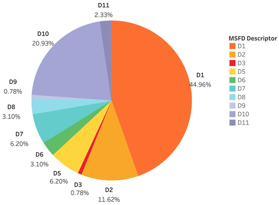
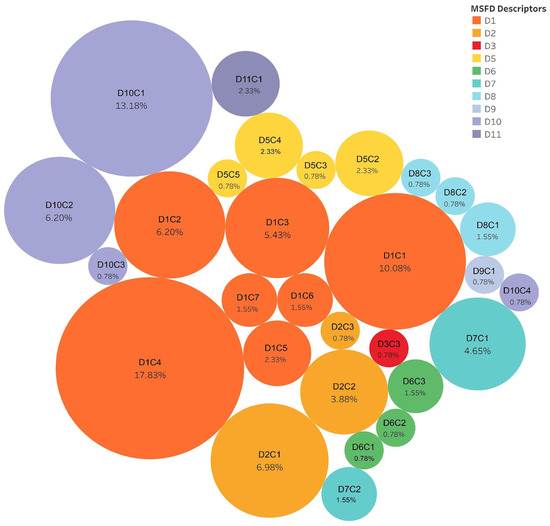
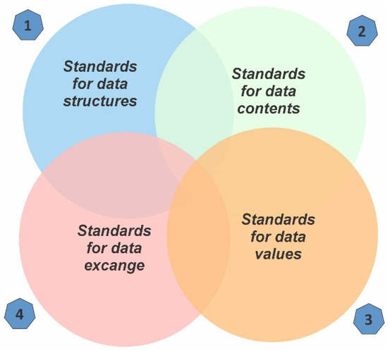
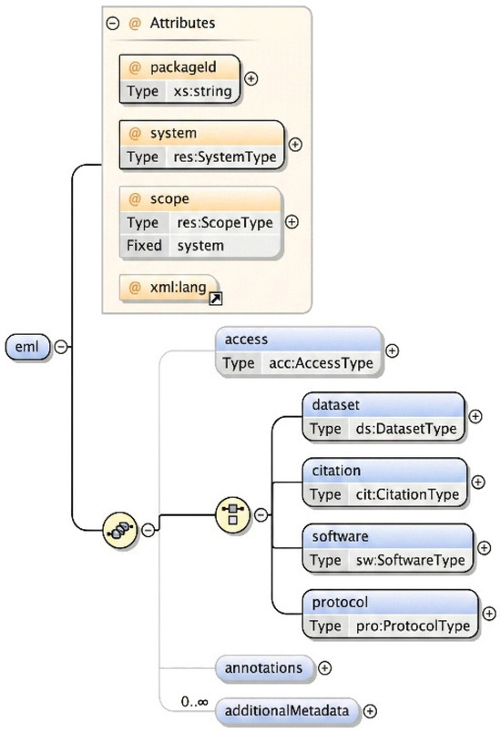
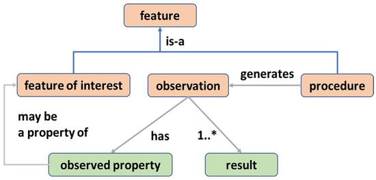
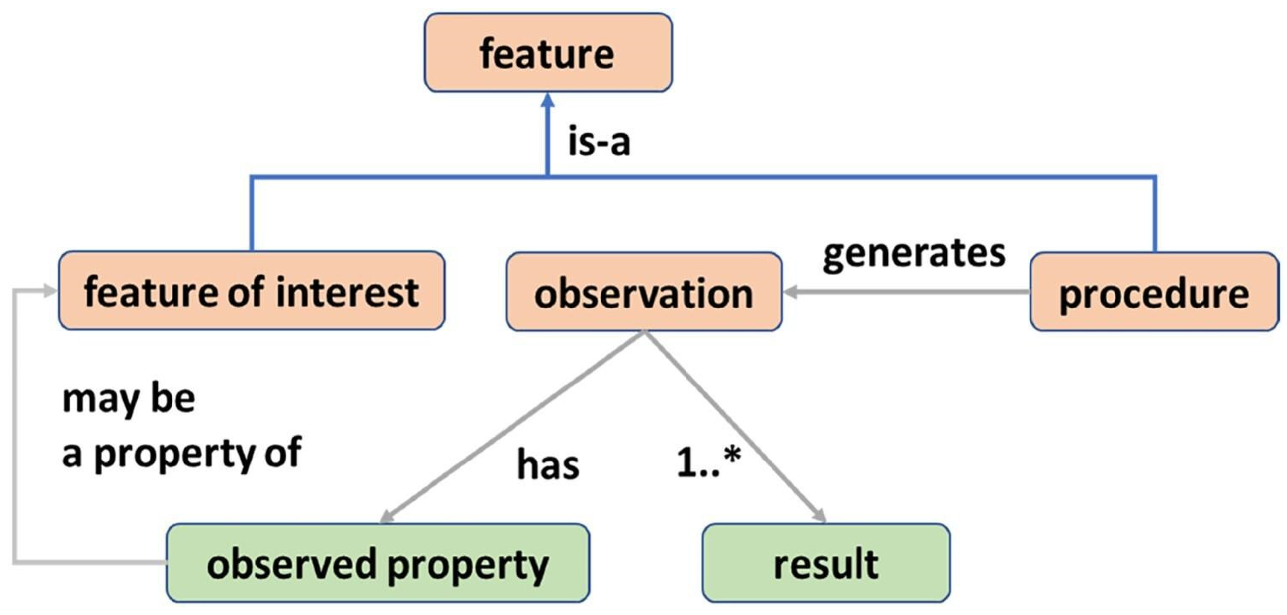
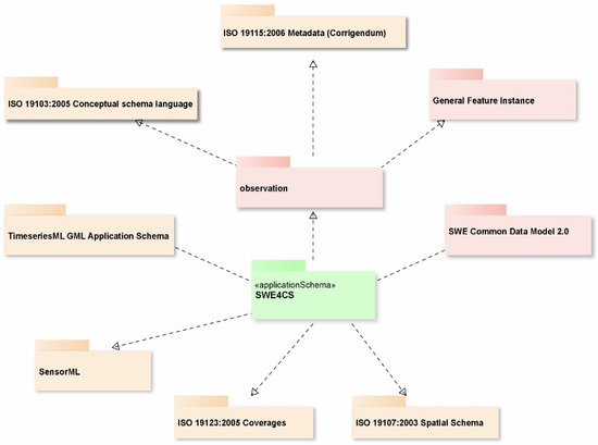
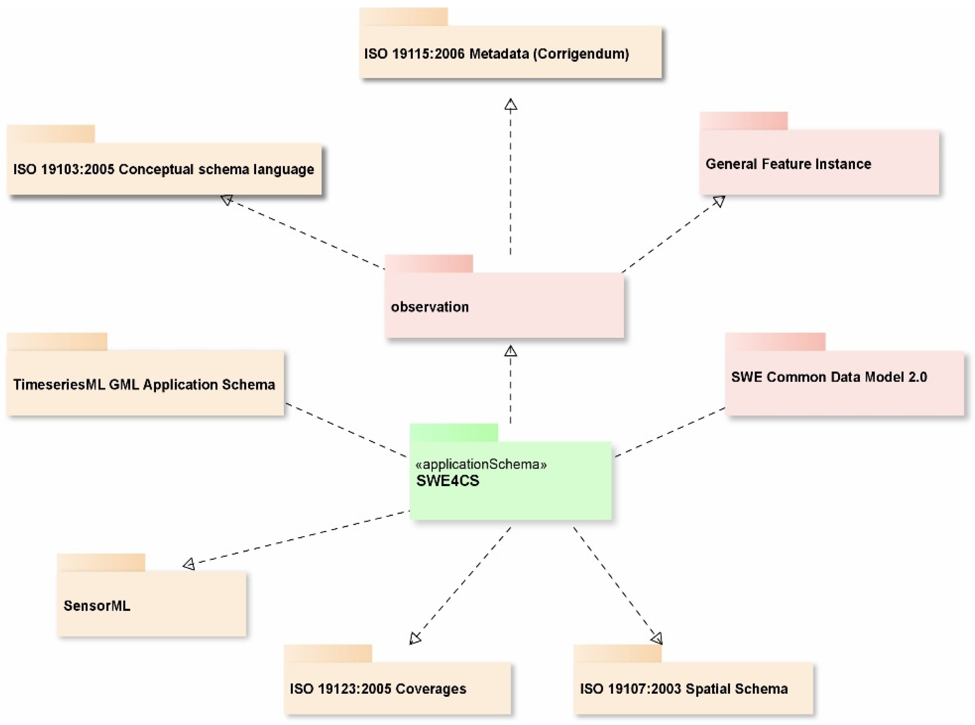
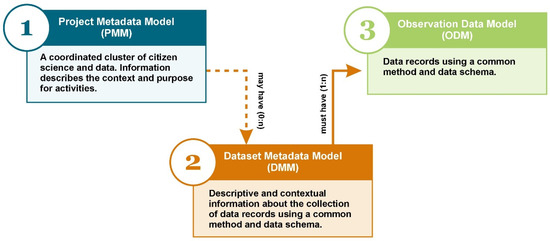
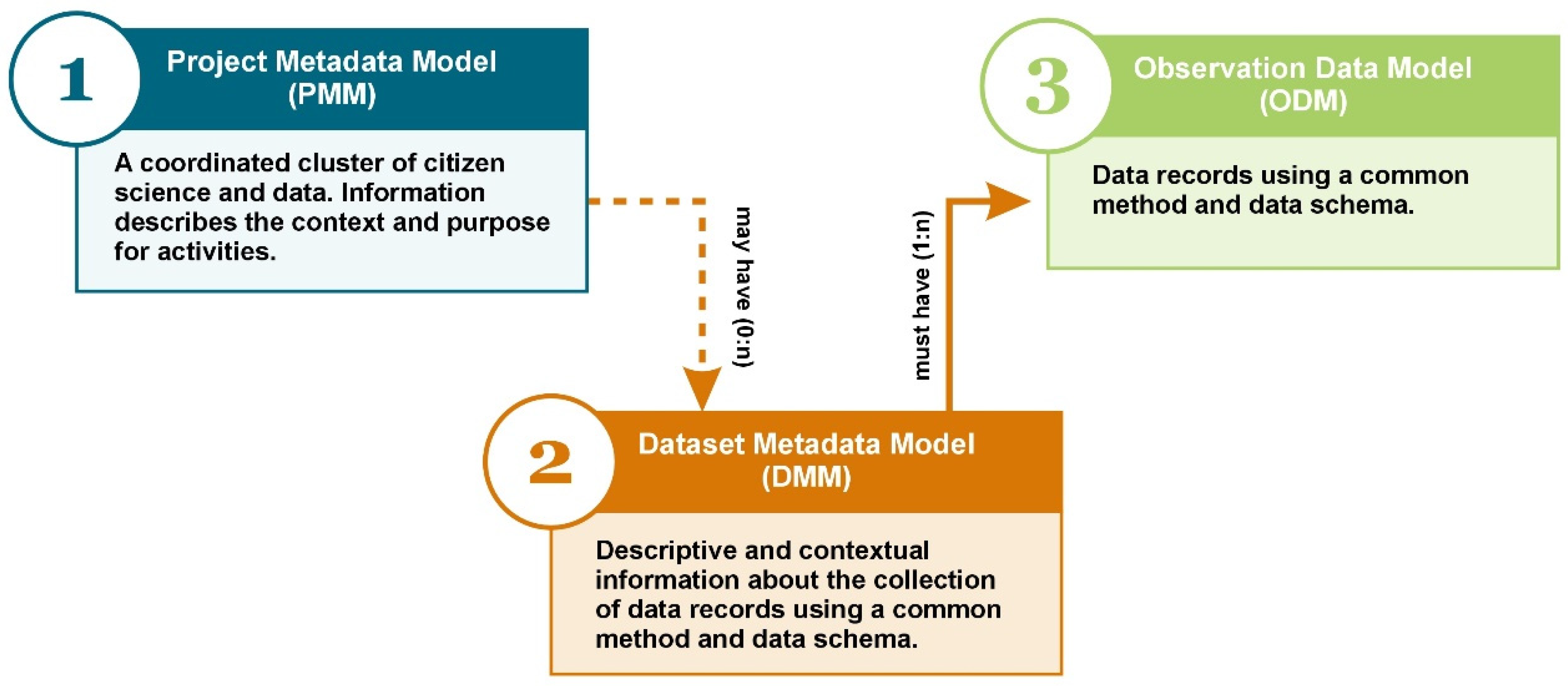

Disclaimer/Publisher’s Note: The statements, opinions and data contained in all publications are solely those of the individual author(s) and contributor(s) and not of MDPI and/or the editor(s). MDPI and/or the editor(s) disclaim responsibility for any injury to people or property resulting from any ideas, methods, instructions or products referred to in the content. |
© 2026 by the authors. Licensee MDPI, Basel, Switzerland. This article is an open access article distributed under the terms and conditions of the Creative Commons Attribution (CC BY) license.