


Abstract
Agricultural plastic waste (APW) is an emerging source of soil pollution and potential micro- and nano-plastic (MNP) contamination in agroecosystems. This study focuses on the Apulia region in southern Italy, a key horticultural and viticultural area with intensive plastic use. Annual APW was estimated for each agricultural feature using a detailed 1:5000 land use map, crop distribution data, and validated plastic waste indices for several plastic application types. The analysis was integrated within a Geographic Information System (GIS) and combined with relative risk indices (RRIs) to compute and map the agricultural plastic pollution risk index (APPRI), a semi-quantitative indicator designated to estimate the potential release of MNPs from agricultural plastics. The APPRI is obtained by multiplying the APW estimates by the RRIs. The results show a clear spatial heterogeneity in plastic waste generation, with the highest APPRI values in vineyards, orchards, olive groves, and greenhouse systems, particularly in the provinces of Foggia and Bari. Cereal-based cropping systems exhibited the lowest risk values. The study proposes an innovative approach, combining land use, APW, and related potential risk into a single mapping tool. This allows for effectively identifying regional hotspots where management and recycling strategies should be prioritized. This GIS-based tool for assessing and visualizing agricultural plastic pollution risk can support evidence-based decision-making and sustainable waste management in agricultural landscapes.
1. Introduction
Plastics have become deeply embedded in modern agricultural activities because they bring clear, immediate benefits [1]. Greenhouse, mulching, and low-tunnel films can increase soil temperature, protect crops, and create a favorable microclimate, thereby enhancing production both in- and off-season [2]. Drip irrigation systems can save water by delivering the required amounts directly to plant roots. Recent advances in agricultural plastics have helped increase yields, extend growing seasons, and make intensive cultivation economically viable in many regions [3]. The properties that make plastics most useful and economically efficient are durability, lightweight, and resistance to degradation. However, this can also cause long-lasting environmental problems when materials are lost, degraded, or mismanaged in the field [4].
When plastic items wear, tear, or are buried in soil, they fragment into micro-plastics (≤5 mm) and nano-plastics (<1 µm) [5]. These small particles accumulate in agricultural soils through multiple pathways: degradation of mulch and greenhouse films, abrasion of irrigation pipes, use of contaminated compost or sewage sludge as soil amendments, atmospheric deposition, and the mismanagement of agricultural plastic waste (APW) after the materials have been extensively used over the years by farmers [6,7]. Among the agricultural plastic applications, particular attention should be paid to mulch films. In fact, research shows that prolonged mulching is responsible for high accumulation of MNPs in soil and negative effects on physical and biological soil indicators [8]. Even the effects on soil health of biodegradable mulch films, proposed as a more sustainable alternative to the conventional ones, need to be investigated more thoroughly, as pointed out by Convertino et al. [9].
Once in the soil, micro- and nano-plastics (MNPs) can change soil physical structure, alter moisture dynamics, and interfere with root growth and seedling establishment [10,11]. The evidence for these effects is growing quickly, together with concern about their influence on crop performance and soil health [12,13]. MNPs can adhere to or be taken up by plant roots and contaminate edible plant parts. Animals that feed on contaminated plants or soil can accumulate these particles themselves [11]. This chain, from plastics in the field to particles in food and animal tissues, creates exposure routes for humans through diet, inhalation of dust, and possibly drinking water [14]. While the full health implications remain under active study, laboratory research has reported inflammatory responses, oxidative stress, and organ-level effects associated with MNP exposure [15,16].
Of particular concern are possible effects on the brain. Emerging toxicology and animal-model studies indicate that very small plastic particles can cross physiological barriers, reach brain tissue, and provoke neuroinflammation, behavioral changes, and other signs of neurotoxicity under certain exposure scenarios [17]. Human data are limited but alarming; recent multidisciplinary investigations have detected microplastics in human organs, including brain samples, and call for urgent research to understand potential links to neurological disease. Taken together, these findings underline that agricultural plastic pollution is not only an environmental or agronomic issue but also a public health concern.
Regions where agriculture is intensive and plastic use is widespread deserve particular attention, since the negative health effects could be accentuated. In fact, as observed by Akca et. al. [18], who analyzed MNPs in soils in the Mediterranean, Aegean, and Marmara regions of Turkey, the presence of MNPs was higher in agricultural areas than in urban ones. Thus, the Apulia region in southern Italy is a significant example, as it is a highly productive agricultural area where plasticulture, such as greenhouses, mulching, and irrigation systems, is common. Past mapping and Geographic Information System (GIS) studies in parts of Apulia have shown that APW accumulates in identifiable hotspots [19,20]. Identifying where plastic waste is produced and accumulates is a necessary first step to designing collection systems, recycling pathways, and policy measures tailored to local conditions. As pointed out by Nath et al. [21], effective waste management practices are crucial to at least mitigate the presence, and consequently, the negative effects, of MNPs in soil. In this regard, the study conducted by Convertino et al. [22] in 2025 showed how valuable the identification of APW hotspots is for further applications, such as the planning of a waste collection center scheme. Furthermore, this mapping approach allows for the identification of the most critical areas to monitor in relation to health issues.
This work focuses on the APW issue in the Apulia region, with a municipal-level detail. The base foundation is the estimate of the APW considering plastic applications (PAs) and crop types. This is the necessary input to quantify the APW-associated risk and develop state-of-the-art risk assessment maps for MNP contamination in soil in the studied region.
In short, plastics in agriculture deliver valuable benefits but create a persistent environmental footprint with negative impacts even on human health [23]. Addressing this problem is challenging and requires good data on where and how APW is produced locally. This is essential to target technically and economically viable solutions toward the areas of greatest need. The proposed novel tool for mapping MNP contamination fills a practical and scientific gap and is useful for immediate policy and management action. It also serves as a foundation for further research on the impacts of agricultural plastics on soils, crops, and human health.
2. Materials and Methods
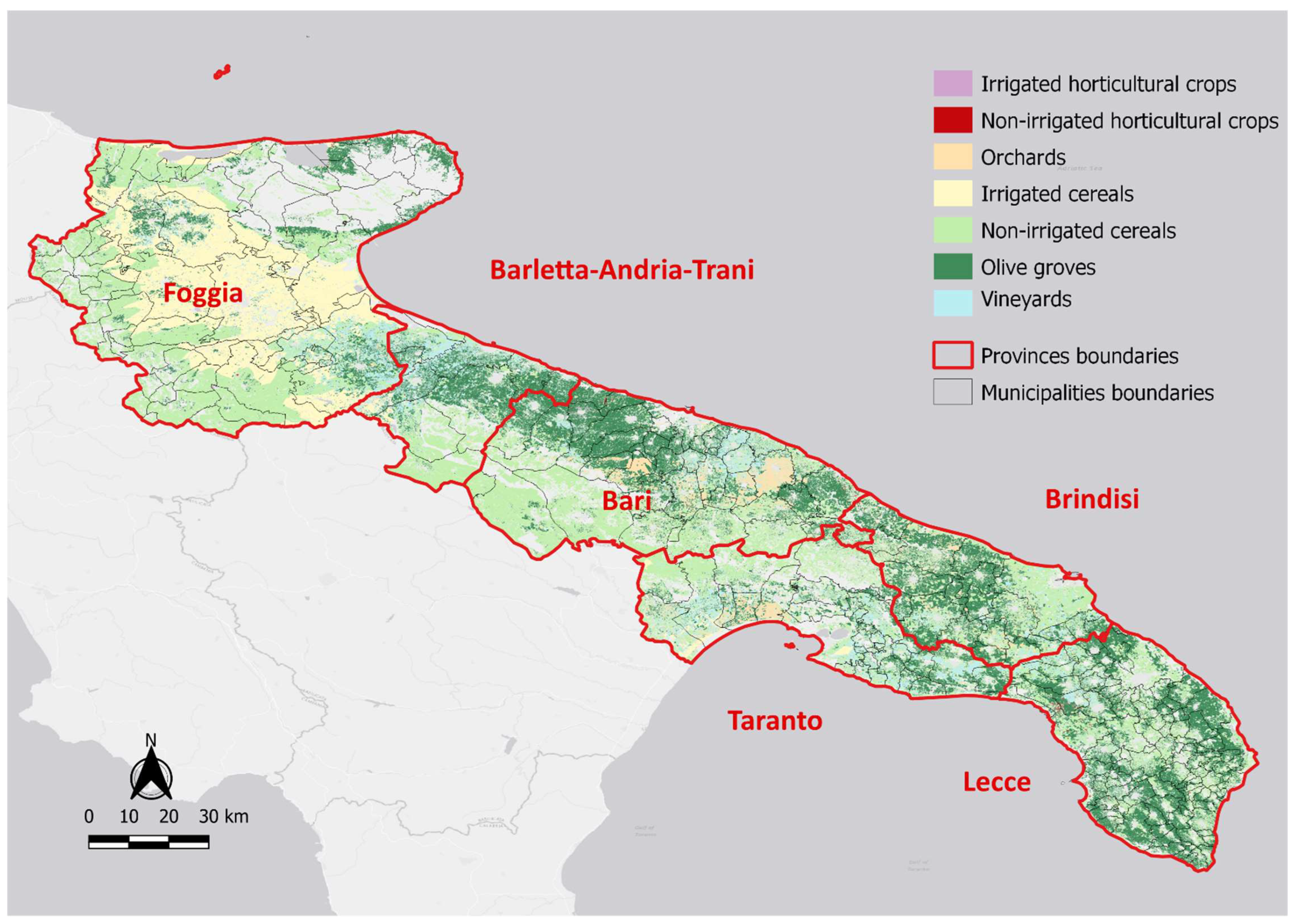
The Apulia region, located in the south-eastern “heel” of the Italian Peninsula, covers an area of approximately 19,500 km2, equivalent to about 6.4% of Italy’s landmass. The region comprises 258 municipalities spread across 6 provinces, whose boundaries are shown in Figure 1. The largest municipality is “Cerignola” in the province of “Foggia”, with an area of approximately 594 km2, followed by the municipality of “Foggia”, with an area of approximately 509 km2. By contrast, the smallest municipalities by area are the collection of islands called “Isole Tremiti” also in the province of “Foggia”, with an area of 3.18 km2, followed by the municipality of “Monteparano”, in Taranto province, with an area of 3.85 km2.
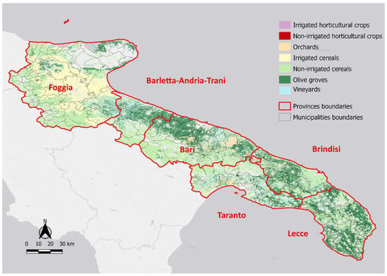
Figure 1.
Cultivation land use classes in the Apulia region.
The agricultural sector is considered a strategic pillar of the Apulia economy and is characterized by a high degree of specialization, export orientation, and climate-related vulnerability. The agricultural area in use accounts for about 67% of the territory, while the total agricultural area reaches about 70%, making it one of the highest among Italian regions after Sicily and Sardinia [24].
Given the extensive use of agricultural land and the widespread application of plastic materials in the agricultural sector, such as greenhouse covering films, films for table grapes, protective nets, and other PAs, the region was selected as a representative case study. This choice aims to assess, based on the evaluation of the APW generated by these applications [20], their potential contribution to soil contamination by MNPs and enables the mapping of such contamination.
Based on the land use map of the study area made available by Regione Puglia [25], the main crops cultivated in the Apulia region are olive groves, vineyards, orchards, irrigated cereals, non-irrigated cereals, irrigated horticultural crops, and non-irrigated horticultural crops. The map corresponds to single features (around 363,000 features for the entire Apulia region) developed at a 1:5000 scale for the entire regional territory and was produced with a minimum mappable unit of 2500 m2. The map was derived through photointerpretation of orthophotos and follows the standards established at the European level according to the CORINE Land Cover project specifications. The legend includes 69 distinct land use classes, providing a detailed and standardized representation of land use patterns across the region. For the purpose of this study, only the classes mentioned earlier (cultivation classes) were taken into consideration (Figure 1).
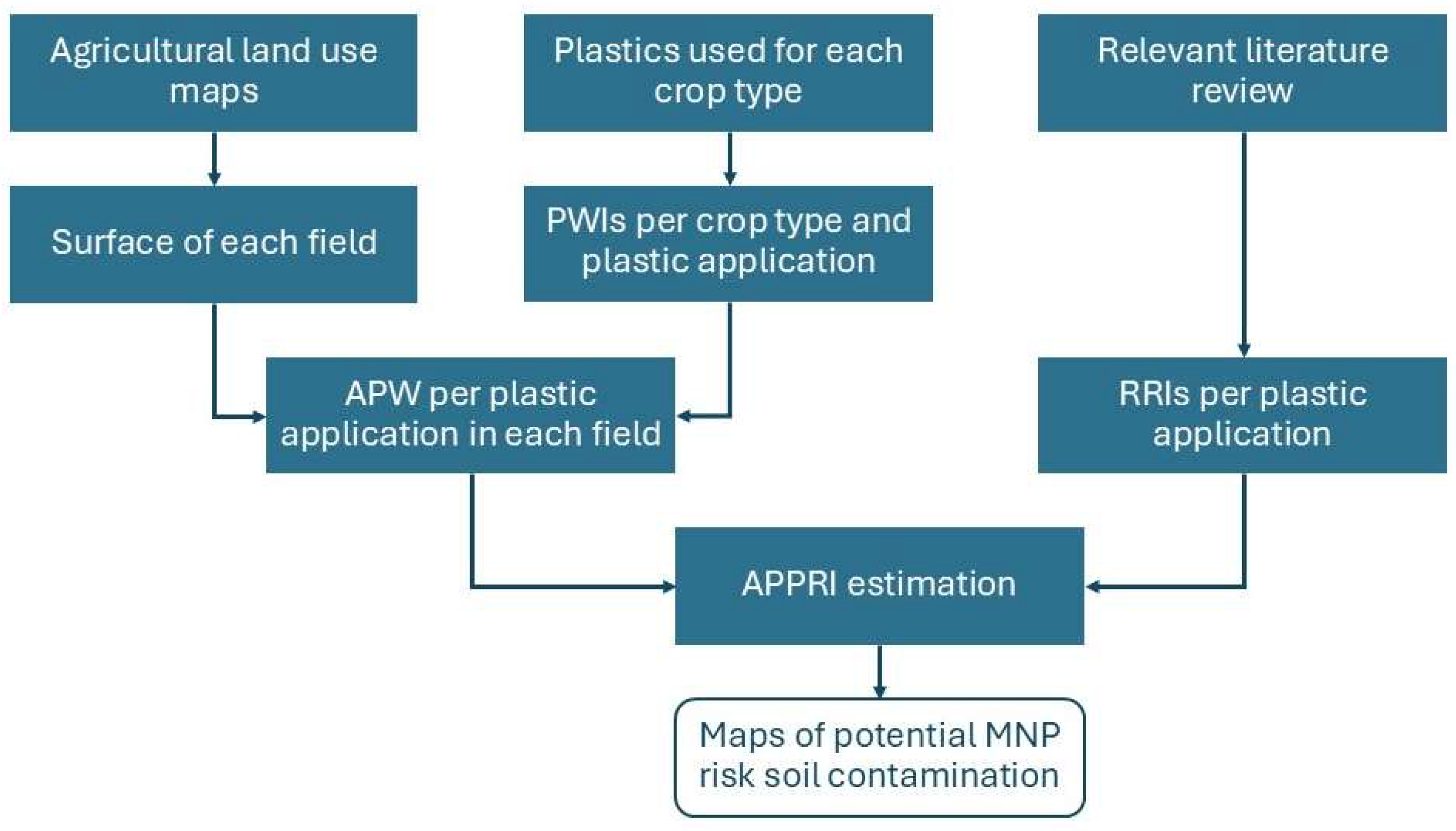
The methodology of producing MNP risk maps was performed in a GIS environment with the free and open-source software QGIS 3.28 [26] and consisted of (Figure 2):
- Merging single Apulia’s land use map vector files from SIT Puglia [25] for each province and then all the region;
- Filtering the classes included in the vector files to retain only the agricultural ones described earlier;
- Understanding the plastics used in the cultivation process for each crop class;
- Calculating the area for each feature using the QGIS embedded field calculator;
- Obtaining APW (kg yr−1) by plastic waste indices (PWIs) and corresponding feature area;
- Applying the MNP risk index, based on the PA risk factors, to the APW generated for each feature, characterized by its specific PAs.
Figure 2.
Workflow of the study methodology.
This allowed the linking of APW with the potential risk of MNP contamination in soil and the generation of corresponding MNP risk maps. Additionally, considering that horticultural crops, taken from land use maps, include both open-field and protected crops, data from the Italian National Institute of Statistics [27] were integrated to differentiate between the two cultivation systems. The same approach was also applied to vineyards, since this region is well known for its heritage in producing both table grapes and wine grapes. This is crucial because table grapes in the region, along with horticultural crops grown in protected environments, are known to be cultivated under protective covering films.
Based on [27], in 2024, horticultural crops in open fields (27 crops) covered an area of around 67,000 ha, which accounts for 77% of the total horticultural crop production, while 21 different horticultural crops covered an area of 33,000 ha in greenhouses, which accounts for the remaining 23% of the total production.
For vineyards in the Apulia region and in the same year (2024), wine grapes covered an area of around 87,000 ha, while table grapes covered around 37,000 ha. This corresponds to a ratio of 70% and 30% for wine grapes and table grapes, respectively. These ratios were taken into account when estimating APW generated by different crop classes and PAs to give more robust estimates.
The development of PWIs and their validation on the Italian territory in Hachem et al. [20] by different agricultural entities (universities, field surveys, questionnaires, farmers’ associations) allowed for the integration of PWIs with land use features (lands) extrapolated from land use maps. Each PWI was assigned to a PA that is used during the cultivation process of the crop classes (Table 1).
Table 1.
Plastic applications used and their corresponding PWIs [20].
After the integration of PWIs with the areas (ha) of the corresponding single features of the land use maps, APW (kg yr−1) was estimated for each PA, and then the total APW was calculated by summing APW per PA for each feature.
From that point onward, a different approach was necessary to establish a link between the amount of APW generated and the risk of soil contamination by MNPs.
Although quantitative estimates cannot yet be established, assessing the relative risk of MNP release from agricultural plastics is critical for understanding environmental exposure pathways. To evaluate this potential in relation to the PAs used in the Apulia region, this research developed a semi-quantitative metric through the formulation of an index designed to compare and rank areas most vulnerable to MNP pollution by agricultural plastics. The resulting ranking system, termed the agricultural plastic pollution risk index (APPRI), integrates the amount of APW generated from each PA in each feature from the land use map with a corresponding relative risk index (RRI). The RRI was derived from recent peer-reviewed studies [4,28] that assess the likelihood of MNP release into soils per plastic type. The studies used as a basis for calculating the RRIs were selected from the available literature because they refer specifically to plastics used for agricultural purposes and their on-farm management, making them particularly suitable for this research.
The Food and Agriculture Organization (FAO) report [28] provides a qualitative assessment of plastic product quantities, their environmental fate, and the potential hazards they pose to human and ecosystem health. This framework attributes specific risk levels and ranks to each PA under consideration, based primarily on expert judgment. Building on this foundation, Briassoulis [4] expanded the FAO framework by including ten additional PAs. The principal distinction between the two methodologies lies in their scope: while the first study includes an impact analysis (covering consequences for humans and the environment), the second study focuses solely on evaluating the risk of soil pollution associated with PAs.
Table 2 presents the RRIs used to generate the risk map for each PA together with those of the reference studies. These indices are associated with end-of-life scenarios, particularly where agricultural plastics are non-recyclable or mismanaged. Mismanagement may be deliberate or may occur unintentionally during material recovery processes, leading to accidental losses. Examples include residual fragments from plant supports and clips, portions of mulching films, nets, irrigation pipes (depending on their thickness and degree of weathering), and small fractions from silage films, among others.
Table 2.
Relative risk index for plastic applications considered in the present study and in the literature studies [4,28].
RRIs were chosen based on those that best described the PAs used in the agricultural fields of the Apulia region. Moreover, RRIs from similar categories between both studies and within the same study were consolidated by taking an average risk value. For instance, a single averaged risk value was assigned to irrigation pipes, encompassing drip irrigation tapes (risk = 10.5 in [4]), rigid surface drip irrigation pipes, drippers (risk = 9.3), and rigid pipe drippers (risk = 8.9).
To prepare the risk map, the following formula was used:
where APWi is the annual waste generation (kg yr−1) from the i-plastic application, and RRIi is a dimensionless factor (Table 2) reflecting the relative potential for MNP generation in soil depending on the i-plastic application. This allows for a weighted estimation that highlights high-risk applications, not only based on volume but also on the intrinsic environmental hazard. The resulting APPRI values were obtained for each feature from the land use map, combining all the specific PAs used in the corresponding feature.
Total APPRI = ∑ APWi × RRIi
Subsequently, the APPRI values were normalized to a scale ranging from 0 to 1 to allow comparability among provinces. The normalized APPRI values were then classified into three contamination risk categories, low, medium, and high, based on equal-interval thresholds of the normalized index. Specifically, low risk corresponds to areas characterized by the lowest relative contribution and accumulation potential of MNPs from agricultural plastic activities, medium risk represents intermediate and transitional conditions, and high risk identifies provinces with the highest relative likelihood of soil contamination by MNPs. It should be emphasized that these categories represent relative risk levels within the study area, rather than absolute concentration thresholds, and are intended to support spatial comparison and prioritization of risk management actions.
Finally, risk values were reported in QGIS to obtain a detailed geo-referenced map of semi-quantitative MNP risk.
3. Results and Discussion
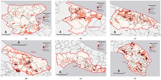
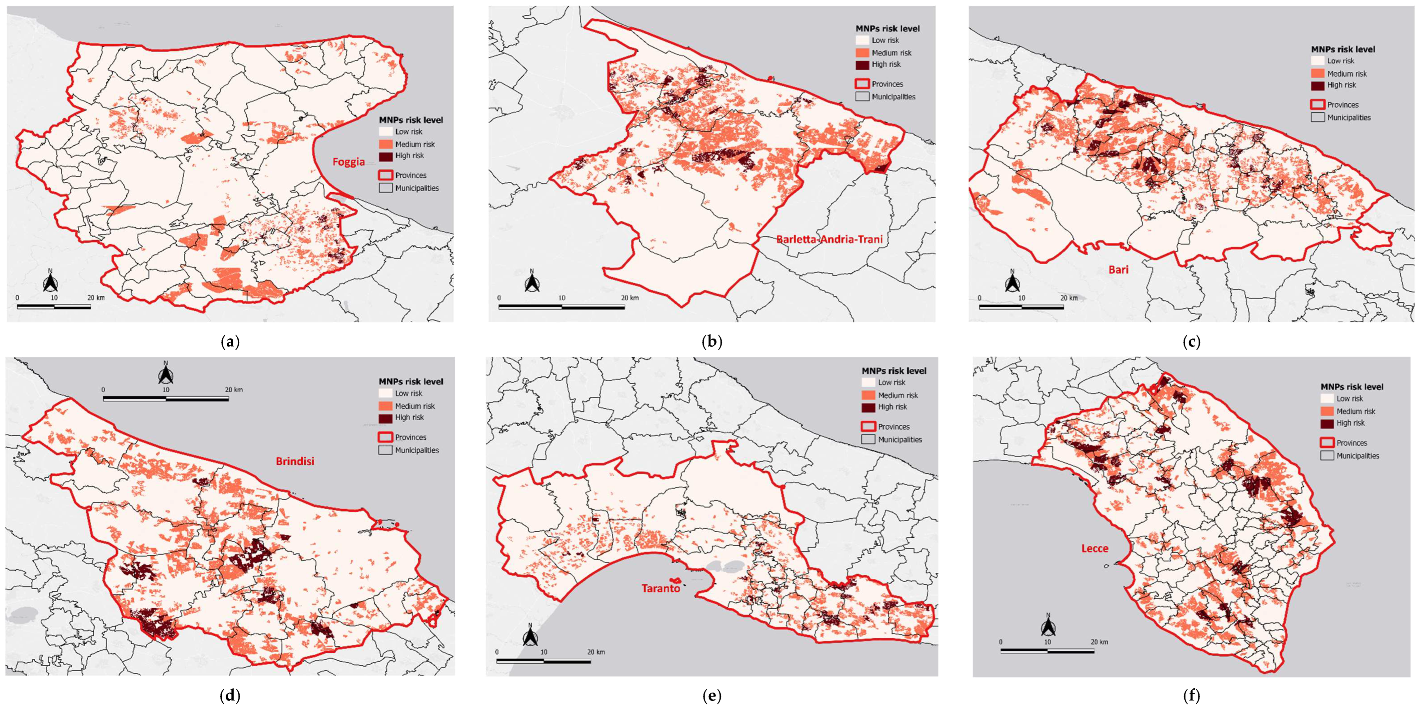
Maps of MNP risk from generated APW in the Apulia region are presented in Figure 3. For better data visualization, each province of Apulia was visualized as a standalone map (Figure 3).
Figure 3.
Micro- and nano-plastics risk in the provinces of Apulia: (a) Foggia; (b) Barletta-Andria-Trani; (c) Bari; (d) Brindisi; (e) Taranto; (f) Lecce.
The analysis of APW generated by agricultural plastics and the associated risk of MNP contamination in soils across the Apulia region revealed clear spatial and material patterns.
The highest levels of total APW and risk were consistently concentrated in vineyards and olive groves. More than seventy fields, including these crops, showed the highest risk of MNP contamination, with associated APW generation ranging from approximately 47,000 to 125,000 kg yr−1.
Some fields of orchards were also considered the highest contributors to APW generation, along with the associated risk of MNPs. The field with the highest amount of generated APW (around 129,000 kg yr−1) was an orchard field with an area of 536 ha and located in the municipality of Grumo Appula in the province of Bari, in Central Apulia.
Non-irrigated and irrigated cereals, as well as open-field horticultural areas, showed negligible plastic waste generation and risk values compared to the other crop classes.
The PAs contributing most to the high generation of APW are nets (103,000 kg yr−1) as well as irrigation pipes (24,000 kg yr−1). These presented the highest risk of MNP contamination to soil. Vineyards and olive groves, characterized by an extensive use of nets and irrigation pipes, were the fields dominating both APW generation and associated MNP risk. In addition, the use of plastic covering films for table grapes, agrochemical containers, fertilizer bags, and plastic support structures contributed to the high MNP levels in vineyards.
Concerning the distribution across the regional territory, the highest associated risk to soil pollution by MNPs, as shown in Figure 3 with dark red color, was mainly concentrated in the provinces of Bari, Brindisi, and Lecce, where vineyards and olive trees have the highest impact. At the municipal level, high concentrations of MNPs were recorded in central Apulia, in the province of Bari near the municipalities of Palo del Colle, Conversano, Giovinazzo, and Bisceglie. In Northern Apulia, in the province of Foggia, high values were recorded specifically in the municipality of Cerignola.
The areas with the lowest risk of MNP contamination were associated with cereal production. These areas are distributed throughout the entire Apulia region in different provinces and are indicated with a light red color.
Overall, the risk of MNP contamination varies across different areas in the Apulia region, ranging from high to low levels depending on the cultivation type and the kinds of PAs used in the production systems.
In general, within the high-impact fields, the highest risk of MNP contamination came from the use of films and nets, followed by irrigation pipes, plastic supports, and containers. The strong overlap between areas of high waste production and elevated risk indicates that the same agricultural practices driving high plastic input are also responsible for greater environmental exposure. Overall, these findings highlight the need for targeted management strategies, especially in vineyard and olive production systems, particularly to improve the handling, reuse, and disposal of films and nets and to mitigate soil contamination by MNPs in southern Italy’s agricultural systems. It is also important to highlight that the outputs of this study are quite unique, since they were achieved thanks to the proposed integrated approach, combining multiple dimensions related to plastics, waste, and risk.
4. Conclusions
This study introduced a GIS-based framework to assess the risk of micro- and nano-plastic (MNP) soil pollution associated with agricultural plastic waste (APW) generated in the Apulia region. The proposed mapping of the agricultural plastic pollution risk index (APPRI) integrates APW and relative risk indices to identify areas with the highest potential for MNP accumulation in soils. The results indicate that vineyards, orchards, olive groves, and greenhouse systems are the main contributors to MNP contamination risk, particularly in the provinces of Foggia and Bari, while cereal-based production systems present minimal risk. The risk map represents an effective tool for estimating the risk in its spatial pattern and prioritizing waste management intervention, including collection, storage, and recycling strategies at the regional scale. The mapping output could also be a useful tool for guiding farmers toward best practices and supporting monitoring programs to track changes over time. The study has limitations, mainly related to the temporal resolution of land use data, which are not yet integrated with remote sensing sources, as well as assumptions on waste recovery. This research does not investigate the possible migration of MNPs between different areas, which could be a further exploration of great scientific interest. Moreover, future developments should include updated datasets, field validation, and integration with monitoring programs to support circular and sustainable agricultural practices.
Author Contributions
Conceptualization, methodology, software, formal analysis, data curation, writing—original draft, and writing—review and editing: A.H. and F.C. Conceptualization, methodology, software, formal analysis, writing—original draft, and writing—review and editing: G.V. Conceptualization, methodology, formal analysis, writing—review and editing, and funding acquisition: E.S. All authors have read and agreed to the published version of the manuscript.
Funding
This research was funded by the European Union’s Horizon 2020 research and innovation program under grant agreement No. 101000210, project PAPILLONS—Plastic in Agricultural Production: Impacts, Life-cycles and LONg-term Sustainability.
Institutional Review Board Statement
Not applicable.
Informed Consent Statement
Not applicable.
Data Availability Statement
Data is contained within the article.
Acknowledgments
This research was carried out as a part of the Project “Plastic in Agricultural Production: Impacts, Lifecycles and LONg-term Sustainability—PAPILLONS” funded by the European Union’s Horizon 2020 research and innovation program under grant agreement No. 101000210.
Conflicts of Interest
The authors declare no conflicts of interest.
Abbreviations
The following abbreviations are used in this manuscript:
| APPRI | Agricultural Plastic Pollution Risk Index |
| APW | Agricultural Plastic Waste |
| GIS | Geographic Information System |
| MNP | Micro- and Nano-Plastic |
| PA | Plastic Application |
| PWI | Plastic Waste Indices |
| RRI | Relative Risk Index |
| yr | Year |
References
- Mongil-Manso, J.; Jiménez-Ballesta, R.; Trujillo-González, J.M.; San José Wery, A.; Díez Méndez, A. A comprehensive review of plastics in agricultural soils: A case study of Castilla y León (Spain) farmlands. Land 2023, 12, 1888. [Google Scholar] [CrossRef] [Scilit]
- Qiang, L.; Hu, H.; Li, G.; Xu, J.; Cheng, J.; Wang, J.; Zhang, R. Plastic mulching, and occurrence, incorporation, degradation, and impacts of polyethylene microplastics in agroecosystems. Ecotoxicol. Environ. Saf. 2023, 263, 115274. [Google Scholar] [CrossRef] [Scilit]
- Hofmann, T.; Ghoshal, S.; Tufenkji, N.; Adamowski, J.F.; Bayen, S.; Chen, Q.; Demokritou, P.; Flury, M.; Hüffer, T.; Ivleva, N.P.; et al. Plastics can be used more sustainably in agriculture. Commun. Earth Environ. 2023, 4, 482. [Google Scholar] [CrossRef] [Scilit]
- Briassoulis, D. Agricultural plastics as a potential threat to food security, health, and environment through soil pollution by microplastics: Problem definition. Sci. Total Environ. 2023, 892, 164533. [Google Scholar] [CrossRef] [Scilit]
- Tian, L.; Jin, J.; Ji, R.; Ma, Y. Microplastics in agricultural soils: Sources, effects, and their fate. Curr. Opin. Environ. Sci. Health 2022, 25, 100311. [Google Scholar] [CrossRef] [Scilit]
- Long, B.; Li, F.; Wang, K.; Huang, Y.; Yang, Y.; Xie, D. Impact of plastic film mulching on microplastic in farmland soils in Guangdong province, China. Heliyon 2023, 9, e16587. [Google Scholar] [CrossRef] [Scilit] [PubMed]
- Lakhiar, I.A.; Yan, H.; Zhang, J.; Wang, G.; Deng, S.; Bao, R.; Zhang, C.; Syed, T.N.; Wang, B.; Zhou, R.; et al. Plastic pollution in agriculture as a threat to food security, the ecosystem, and the environment: An overview. Agronomy 2024, 14, 548. [Google Scholar] [CrossRef] [Scilit]
- Gencer, M.; Akça, M.O.; Acar, M.; Abdelrazik, Z.S.; Wahab, T.S.; Gündoğdu, S.; Turgay, O.C. Microplastic accumulation and soil quality changes under varying plastic mulching durations in the Mediterranean region. J. Soil Sci. Plant Nutr. 2026, 58, 03010–03014. [Google Scholar] [CrossRef] [Scilit]
- Convertino, F.; Carroccio, S.C.; Cocca, M.C.; Dattilo, S.; Dell’Acqua, A.C.; Gargiulo, L.; Nizzetto, L.; Riccobene, P.M.; Schettini, E.; Vox, G.; et al. The fate of post-use biodegradable PBAT-based mulch films buried in agricultural soil. Sci. Total Environ. 2024, 948, 174697. [Google Scholar] [CrossRef] [Scilit]
- Wong, A.E.; Taylor, G. Plants and microplastics: Growing impacts in the terrestrial environment. Front. Plant Sci. 2025, 16, 1666047. [Google Scholar] [CrossRef] [Scilit]
- Srećkov, Z.; Mrkonjić, Z.; Bojović, M.; Nikolić, O.; Radić, D.; Vasić, V. Microplastic uptake in vegetables: Sources, mechanisms, transport and food safety. Toxics 2025, 13, 609. [Google Scholar] [CrossRef] [Scilit]
- Aralappanavar, V.K.; Mukhopadhyay, R.; Yu, Y.; Liu, J.; Bhatnagar, A.; Praveena, S.M.; Li, Y.; Paller, M.; Adyel, T.M.; Rinklebe, J.; et al. Effects of microplastics on soil microorganisms and microbial functions in nutrients and carbon cycling—A review. Sci. Total Environ. 2024, 924, 171435. [Google Scholar] [CrossRef] [Scilit]
- Sajjad, M.; Huang, Q.; Khan, S.; Khan, M.A.; Liu, Y.; Wang, J.; Lian, F.; Wang, Q.; Guo, G. Microplastics in the soil environment: A critical review. Environ. Technol. Innov. 2022, 27, 102408. [Google Scholar] [CrossRef] [Scilit]
- Gan, A.J.W.; Chia, K.F.; Lim, C.L.; Tan, B.K.; Wong, S.F.; Chye, S.M.; Leong, C.O.; Koh, R.Y. Neurotoxicity of nanoplastics: A review. F1000Research 2024, 13, 793. [Google Scholar] [CrossRef] [Scilit]
- Yee, M.S.-L.; Hii, L.-W.; Looi, C.K.; Lim, W.-M.; Wong, S.-F.; Kok, Y.-Y.; Tan, B.-K.; Wong, C.-Y.; Leong, C.-O. Impact of Microplastics and Nanoplastics on Human Health. Nanomaterials 2021, 11, 496. [Google Scholar] [CrossRef] [Scilit]
- Mahmud, F.; Sarker, D.B.; Jocelyn, J.A.; Sang, Q.-X.A. Molecular and Cellular Effects of Microplastics and Nanoplastics: Focus on Inflammation and Senescence. Cells 2024, 13, 1788. [Google Scholar] [CrossRef] [Scilit]
- Prüst, M.; Meijer, J.; Westerink, R.H.S. The plastic brain: Neurotoxicity of micro- and nanoplastics. Part. Fibre Toxicol. 2020, 17, 24. [Google Scholar] [CrossRef] [Scilit]
- Akça, M.O.; Gündoğdu, S.; Akça, H.; Delialioğlu, R.A.; Aksit, C.; Turgay, O.C.; Harada, N. An evaluation on microplastic accumulations in Turkish soils under different land uses. Sci. Total Environ. 2024, 911, 168609. [Google Scholar] [CrossRef] [Scilit] [PubMed]
- Blanco, I.; Loisi, R.V.; Sica, C.; Schettini, E.; Vox, G. Agricultural plastic waste mapping using GIS: A case study in Italy. Resour. Conserv. Recycl. 2018, 137, 229–242. [Google Scholar] [CrossRef] [Scilit]
- Hachem, A.; Convertino, F.; Batista, T.; Baptista, F.; Briassoulis, D.; Valera Martínez, D.L.; Moreno Teruel, M.Á.; Nizzetto, L.; Papardaki, N.-G.; Ruggiero, G.; et al. GIS mapping of agricultural plastic waste in southern Europe. Sci. Total Environ. 2024, 946, 174491. [Google Scholar] [CrossRef] [Scilit]
- Nath, S.; Enerijiofi, K.E.; Astapati, A.D.; Guha, A. Microplastics and nanoplastics in soil: Sources, impacts, and solutions for soil health and environmental sustainability. J. Environ. Qual. 2024, 53, 1048–1072. [Google Scholar] [CrossRef] [Scilit] [PubMed]
- Convertino, F.; Vox, G.; Blanco, I.; Hachem, A.; Schettini, E. Plastic waste management in agriculture through a GIS-based territory design approach. Resour. Conserv. Recycl. 2025, 217, 108210. [Google Scholar] [CrossRef] [Scilit]
- Boctor, J.; Hoyle, F.C.; Farag, M.A.; Ebaid, M.; Walsh, T.; Whiteley, A.S.; Murphy, D.V. Microplastics and nanoplastics: Fate, transport, and governance from agricultural soil to food webs and humans. Environ. Sci. Eur. 2025, 37, 68. [Google Scholar] [CrossRef] [Scilit]
- Cammerino, A.R.B.; Ingaramo, M.; Piacquadio, L.; Monteleone, M. How much longer can we tolerate further loss of farmland without proper planning? The agrivoltaic case in the Apulia region (Italy). Agronomy 2025, 15, 1177. [Google Scholar] [CrossRef] [Scilit]
- SIT Puglia. Available online: https://webapps.sit.puglia.it/freewebapps/UDS2011/index.html (accessed on 10 November 2025).
- Quantum Geographic Information System QGIS. Available online: https://www.qgis.org (accessed on 10 November 2025).
- Italian National Institute of Statistics. Crops. Available online: https://esploradati.istat.it/databrowser/#/it/dw/categories/IT1,Z1000AGR,1.0/AGR_CRP/DCSP_COLTIVAZIONI (accessed on 11 November 2025).
- Food and Agriculture Organization of the United Nations. Assessment of Agricultural Plastics and Their Sustainability: A Call for Action; FAO: Rome, Italy, 2021; Available online: https://openknowledge.fao.org/handle/20.500.14283/cb7856en (accessed on 10 November 2025).

Disclaimer/Publisher’s Note: The statements, opinions and data contained in all publications are solely those of the individual author(s) and contributor(s) and not of MDPI and/or the editor(s). MDPI and/or the editor(s) disclaim responsibility for any injury to people or property resulting from any ideas, methods, instructions or products referred to in the content. |
© 2026 by the authors. Licensee MDPI, Basel, Switzerland. This article is an open access article distributed under the terms and conditions of the Creative Commons Attribution (CC BY) license.