


Abstract
This article explores the nature, extent, and implications of Roman military activity in the western Iberian Peninsula between the Late Republic and the early Empire, from conquest to control and colonisation, analysing how geography, local resistance, and imperial interests shaped the deployment of Roman forces. Drawing on legacy archaeological records, field observations, and the systematic analysis of remote sensing data, it examines the available evidence from a broad region encompassing the modern Portuguese districts of Aveiro, Coimbra, and Viseu, where traditional narratives often emphasise a swift and decisive conquest assumed to have left scarce material traces. The identification of previously unrecorded potential military sites through remote sensing, combined with a re-evaluation of known archaeological findings, including military camps and associated material culture, suggests a more nuanced and protracted process. This study synthesises the existing data and explores new sites to propose a chronological framework and explore possible strategic functions of the Roman military presence in the region. It analyses the interaction between the Roman army and local populations, identifying patterns of resistance, resilience, negotiation, and the subsequent colonisation and integration. The archaeological record from the Central region of Portugal offers critical insights into the logistical challenges, adaptive strategies, and long-term impacts of Roman military operations on the indigenous communities and the broader socio-political transformation of western Iberia.
1. Introduction
The transformation of Western Hispania from a contested frontier into a stable component of the Roman Empire was neither abrupt nor uniform. It unfolded through a complex sequence of military interventions, infrastructural investments, and administrative reconfigurations that gradually reshaped indigenous landscapes. Nevertheless, the development of these processes at local and regional levels has been largely overlooked, often subsumed under broader, unilateral and unilinear ‘Romanisation’ interpretations [1], which have increasingly been challenged by approaches emphasising negotiation, local agency and the variable character of imperial integration [1,2,3]. With growing evidence of Roman military activity, the area corresponding to the modern districts of Aveiro, Coimbra and Viseu provides a useful regional case study (Figure 1). Whereas a previous study [4] focused primarily on the identification and reassessment of individual military sites, this paper integrates these sites with newly identified evidence, regional mobility, extractive landscapes, epigraphy, and settlement change to examine the transition from conquest to imperial consolidation. Following a holistic approach, this study thus examines both old and new archaeological evidence to situate the Roman military sites identified in this region within the wider archaeological and historical context. As this region is nestled between two well-studied clusters of Roman military activity in the Tagus valley [5,6,7] and northern Portugal [8,9], this study helps bridge the existing gap along the Atlantic façade.
Figure 1.
Research area and location of the sites and places mentioned throughout the text (figure by authors).
A central analytical distinction employed in this study is that between Roman conquest and imperial consolidation. This distinction follows recent approaches that treat Roman expansion not as a single event or a linear process of “Romanisation”, but as a variable and often prolonged sequence of military coercion, negotiation, administrative reorganisation and local response [1,2,3,10]. Conquest refers to periods of active military expansion, characterised by campaign warfare and rapid troop movement, typically producing temporary or semi-permanent camps that are archaeologically subtle and difficult to interpret without systematic survey and remote sensing [11,12,13,14]. Post-conquest imperial consolidation, by contrast, often entails the army’s gradual shift from conquest-oriented campaigns to operations focused on security, logistics, and territorial management [15]. This phase involved the redistribution of military forces, often at a reduced scale and distributed across landscapes rather than concentrated in a single permanent base, to secure territory, protect infrastructure and support emerging administrative and economic systems. Rather than a simple withdrawal of the army, consolidation frequently entailed a transformation in military function and visibility. This conceptual model reframes Roman military presence not as an isolated “frontier” but as a diffuse network of control and mobility integrated with civilian settlement patterns [11,15].
By integrating new remote sensing data, archaeological evidence, and epigraphic and literary sources, this paper seeks to reconstruct both the strategic rationale that might have guided Roman campaigns and the subsequent processes by which military landscapes were absorbed into imperial structures. Through this approach, the study contributes to a growing reassessment of the region of Central Portugal’s role in the conquest and consolidation of western Iberia, emphasising that military activity should be viewed not as a brief prelude to integration and colonisation but as a formative force shaping regional identity and settlement patterns.
2. Roman Military Archaeology in the Western Iberian Peninsula
The study of Roman military archaeology developed unevenly across the western Iberian Peninsula, largely conditioned by the visibility of archaeological remains [6,7,14,16]. Research has traditionally focused on large, well-defined permanent legionary bases, while temporary, less monumental, and less visible military installations remained underrepresented until the widespread adoption of aerial and remote-sensing methodologies. In several areas of western Iberia, by contrast, the existing scholarship has traditionally relied more extensively on literary sources than on archaeological evidence, prioritising political history and debating putative locations for the sites mentioned in the texts over the archaeology of military contexts [5,11,17,18]. Classical authors, such as Appian [19] and Cassius Dio [20], provide general narratives of the principal military campaigns, particularly for the Late Republican and Augustan periods, yet offer limited insight into army-related infrastructure, movement patterns, logistics, or the long-term military organisation of a territory. The relative scarcity of substantial military architecture has further encouraged modern scholarship to interpret the region as having been rapidly pacified following conquest, thereby obviating the need for a sustained military presence.
From the late twentieth century onwards, this interpretative framework was increasingly challenged by broader developments in Roman military archaeology and landscape studies. In Hispania, the combination of remote sensing, GIS and field survey has been especially important for recognising temporary camps, analysing their morphology and assessing the local adaptation of Roman camp design [14,21,22]. Scholars emphasised that Roman military control did not necessarily depend upon permanent, stone-built fortresses, but could instead operate through temporary camps, small garrisons, and strategic control of communication routes. This distinction between permanent forts, semi-permanent installations and temporary campaign camps is well established in studies of Roman military architecture, although local forms varied considerably across provinces [12,23,24]. In the context of the western Iberian Peninsula, this shift prompted renewed attention to less archaeologically visible forms of military occupation, including short-lived camps and dispersed installations identified through field surveys and remote sensing [11,13,25,26].
In Portugal, however, Roman military archaeology remains comparatively understudied, a situation arguably closely linked to the slow development and limited application that aerial archaeology experienced in the country [27]. The relatively small number of military contexts recorded has largely been identified through artefactual evidence, notably particular typologies of Late Republican ceramics [17] and, especially, the occurrence of glandes plumbeae, lead sling bullets [28]. Consequently, the extensive scholarship on the processes of conquest and ‘Romanisation’ has traditionally focused on indigenous hillforts, Roman road networks, and urban centres [29,30], while military installations have seldom been identified or systematically investigated in this context. The investigation of Roman military activity in the western Iberian Peninsula thus relied heavily on literary sources [17], with several studies largely repeating earlier assessments or postulating hypothetical locations for the places mentioned in the classical sources [5]. It was only in recent decades that the Roman army began to be considered an active agent in shaping rural landscapes and regional organisation. Despite the strategic assets of the Centro region and its position between the well-studied military clusters of the Tagus valley and northern Portugal, Roman military evidence has been largely overlooked, and the study of this region as a military landscape remains insufficient.
3. Geographical Background and Rationale
The region of central Portugal framed between the Central System and the Douro River, largely corresponding to the modern administrative districts of Aveiro, Coimbra and Viseu, is characterised by a rugged and highly compartmentalised landscape dominated by mountain ranges and elevated plateaus, crossed by incised river valleys [31]. Its southern sector is structured by the western extensions of the Central System, particularly the Serra da Estrela, Serra do Açor, and Serra da Lousã. At the same time, the Douro River forms the northern hydrographic limit of this study region. Between these boundaries lies a complex terrain, geomorphologically composed primarily of granitic and schist formations of the Iberian Massif, producing narrow valleys, steep slopes, and elevated ridgelines that frequently exceed 1000 m above sea level [31]. This mountainous environment contrasts with the more moderate topography of certain intramontane depressions and plateau sectors, particularly along the middle Mondego basin and the Beira Alta region. The rugged interior also displays a significant contrast with the coastal areas, broadly characterised by plains and soft hills gradually increasing towards the east [32], which constituted a primary north–south circulation axis of the whole region. Indeed, the main Roman road connecting the towns of Olisipo and Bracara Augusta crossed through this region [33].
Major river systems constituted the principal natural corridors towards the interior of this region and historically conditioned settlement, territorial organisation, and communication. These corridors are relevant not only as routes of movement, but also as structured visual and topographic landscapes in which prominence, intervisibility and control of passage could shape the location of military installations [14,21]. Indeed, the River Mondego, the longest river entirely within Portuguese territory and whose basin drains most of the area of study, exhibits a marked east–west gradient, extending from the Estrela Mountains in the east to the Atlantic coastline in the west. This geographical corridor, defined by the river valley, constitutes a principal axis of mobility, facilitating longitudinal movement along the northern fringes of the mountain ranges forming the Central System. While it provides access to a network of mountain passes that enable transverse crossings of the mountainous terrain, several of which serve as strategic nodes linking major inland routes to coastal access pathways, the Mondego valley is also crossed by the same ancient north–south main mobility axis [33] mentioned above. Additionally, the river’s dimensions and hydrological characteristics permitted considerable fluvial navigation. Following the studies of Alarcão [29], the lower Mondego area arguably constituted a large estuary in antiquity, with significant flow also in tributaries that are now small rivers but were navigable in the past. This allowed for maritime shipping to delve deep into this territory, reaching the significant settlements of Conimbriga and Aeminium. From the latter (modern-day Coimbra), the Mondego would still be navigable upstream for smaller vessels, boosting mobility between interior and coastal areas. Indeed, riverine navigation was one of the principal aspects noted by Strabo [34] (III, III, 4) for this region.
The region was also exceptionally rich in natural resources of considerable economic and strategic value. While tin, lead, and iron occurred in several parts of the study area [35,36], the most relevant mineral resource for the Roman period was gold. This metal occurred both in primary deposits on the Central System and in quaternary secondary deposits along the rivers Alva and Ceira, southern tributaries of the Mondego. Though insufficiently studied, the visible remains of open-cast mining operations along these rivers suggest highly intensive and extensive exploitation in antiquity [37,38,39].
Despite a relatively early academic interest in Roman camps and a significant archaeological record, Roman military archaeology has been, until recently, largely overlooked in this region. Additionally, the recent availability of remote sensing datasets provides a new methodological framework to explore the traditionally inconspicuous traces of Roman military activity across the landscape. At the same time, drawing on epigraphic and other archaeological data, namely the already mentioned ubiquitous evidence for large-scale gold exploitation, this landscape offers a unique opportunity to explore how the infrastructure of conquest transitioned into the durable colonial frameworks that supported provincial governance, economic integration, and exploitation [40].
4. Materials and Methods
This study adopts a multifaceted methodological approach, combining geospatial datasets with epigraphic, literary, and archaeological evidence, both old and new, to reconstruct the Roman military presence in this part of Central Portugal and contextualise it within the broader landscape and subsequent historical framework.
4.1. Historical and Literary Sources
As the Roman conquest of the Iberian Peninsula was a lengthy and uneven undertaking spanning multiple centuries, the available literary sources documenting Roman military intervention are provided by a wide range of authors and are thus equally uneven, often lacking detailed geographical information or mentioning place names that have not been definitively identified. [17]. In this study, literary sources were reviewed to establish a broad historical framework, but their frequent ambiguity limits conclusive chronological and geographical associations. The selection of literary sources was based on previous assessment of the available corpus and included all texts containing explicit or potentially relevant references to military activity in the central-western Iberian Peninsula. A comprehensive list of the sources analysed is available in Table S1 of the Supplementary Materials.
4.2. Archaeological and Epigraphic Data
As both conquest and early colonisation undertakings are intimately connected to the Roman military, this study primarily assesses army-related sites. Within the study area, the Mondego basin boasts the most significant concentration of Roman military sites. Indeed, the sites of Mata Velha de Antanhol (MVA), Valado de Santa Quitéria (VSQ), and Lomba do Canho (LDC) have long been known. This set was recently expanded during analysis of the available LiDAR data for this region, which revealed a significant, previously unknown site at Outeiro de Santa Cruz (OSC). Closer to the Douro, the Roman military sites of Alto do Golado (ADG) and Montedufe (MDF) have also been recently documented [4]. These sites will be described in detail ahead.
This study initially entailed an extensive and meticulous analysis of all published archaeological literature and available excavation reports for the previously known sites. As anticipated, the level of detail available varies across sites and the extent of the investigations undertaken thus far. While the site of LDC has been excavated, and the results are documented across numerous publications that address not only the structures unearthed but also the various materials discovered therein [41,42,43,44,45,46], MVA is known solely from earlier references and surface and aerial surveys. Contrastingly, however, the latter has garnered more extensive academic attention and is frequently featured in studies on the Roman conquest of the western Iberian Peninsula [17,47,48,49]. The VSQ site is known primarily from two mid-twentieth century works [50]. Although it has undergone a small excavation in recent years, there are no reports or published data available. This inconsistency in the reliability of the available data and the absence of supplementary, more substantiated evidence have even prompted more recent scholars [48] to question the identification of some of these sites as Roman military contexts. The sites of ADG and MDF were identified through historic and recent aerial photography. Although both sites still lack dedicated archaeological fieldwork, their military nature is probable based on building characteristics and topographies, with clear parallels elsewhere in the Iberian Peninsula [4].
Other categories of archaeological evidence considered in this study are numismatic finds and inscriptions. The former have recently attracted renewed interest, culminating in an extensive and comprehensive synthesis [51], whereas the epigraphic data were compiled from both recent and older publications. Additionally, the ancient mining remains, which are abundant in the Portuguese Centro region, received particular attention, especially the traces of the open-cast water-powered exploitation of gold-bearing alluvial deposits that extend over a considerable area of the Alva and Ceira valleys, tributaries of the Mondego. Although these gold-mining traces have received growing scholarly attention in recent years [37,39,52], a systematic and comprehensive archaeological survey and subsequent study of the extensive mining landscapes are still lacking. To situate the military sites in this area within their wider landscape context, remote-sensing-based mapping of all extraction zones was undertaken as part of the present study.
4.3. Remote Sensing Datasets, Mapping and Ground-Truthing
The remote sensing data explored in this study was mostly obtained from the recent LiDAR survey of the Portuguese territory commissioned by the Direção-Geral do Território (DGT). Before this release, remote sensing data availability was rather limited, as access to historical aerial imagery remains restricted. Indeed, the collections from the SPLAL (Sociedade Portuguesa de Levantamentos Aéreos, Lda.) flight conducted between 1937 and 1957, as well as the RAF (Royal Air Force) and the USAF (United States Air Force) aerial coverages acquired during the 1940s and 1950s, are controlled by the Centro de Informação Geoespacial do Exército (CIGeoE) [53] and are not publicly accessible. Consequently, a comprehensive and systematic analysis of these archives was not possible for the whole study area. Nevertheless, a limited number of archival aerial images corresponding to selected areas of interest were acquired and analysed. This analysis of archival aerial imagery was complemented by a small dataset supplied by the DGT, comprising historical aerial photographs from various non-systematic flights conducted over the last five decades. In this case, the data can be partially accessed online at lower image resolution, allowing for a limited assessment that nonetheless provides relevant information on land use and landscape changes.
Additionally, a comprehensive array of available high-resolution satellite imagery was consulted during this research, particularly imagery from Bing Maps, ESRI Wayback, and Google Earth. This broad analysis of imagery was further complemented with recent true-colour and near-infrared aerial orthophotographies from DGT, namely the data from the 1995, 2004–2006, and 2018 surveys, which are available through Web Map Services (WMS) and an online visualisation platform. As most of these sources allow for a retrogressive analysis of aerial and satellite imagery, they have proved useful not only to complement and, where feasible, validate the LiDAR assessment, but also to assess changes in land use and the impact of wildfires and forestry undertakings on the various archaeological features.
The airborne LiDAR survey commissioned by DGT [54,55] was particularly relevant in this study. The classified point cloud files used to compute digital models for the entire study area were downloaded from the recently established DGT Centro de Dados. The dataset has an average point density of approximately 10 points per square meter, allowing for the generation of Digital Terrain Models (DTMs) with a spatial resolution of 0.5 m, which are already available. Both the raw point clouds and the derived terrain and surface models are publicly available under a Creative Commons license.
The processing methodology employed in this study encompassed two primary approaches. Initially, the 0.5 m DTMs were downloaded and subsequently processed and resampled with the software Planlauf/TERRAIN (https://planlaufterrain.com/; version 2026) to produce a 1 m resolution LRM-enhanced DTM for the whole study area (low pass filter radius 10 pt; height difference max 0,1 m). This relatively straightforward procedure enables efficient preliminary evaluation of LiDAR data, which can then be explored in a three-dimensional framework. Subsequent analyses of the archaeological sites discussed below involved applying various visualisation techniques to the 0.5 m DTMs provided by DGT. The Relief Visualisation Toolbox (RVT) (version 2.2.1) [56] was used for this purpose, with particular emphasis on the local relief model [57] and enhanced multi-scale topographic position (v4) (using predefined parameters) [58,59], as these methods proved to be the most effective.
In the case of Mata Velha de Antanhol, which was severely impacted by modern undertakings, archival aerial imagery from the SPLAL flight acquired in 1947 was also analysed [60]. These historical aerial photographs were processed using photogrammetric techniques in Agisoft Metashape to produce a georeferenced digital surface model (DSM) and orthophoto, following a methodology already described elsewhere [61,62].
This study depended on visual inspection and interpretation of the data, guided by prior knowledge of the subject and the regional archaeological record. In the case of Roman military sites, this interpretation relied on the recognition of recurrent morphological traits, but also on the awareness that Roman camps frequently adapted standard planning principles to local topography and operational needs [21,24]. Though visualisation techniques can facilitate the interpretative process, it remains a subjective undertaking that largely depends on the experience of the person interpreting the data [63].
The assessment of remote sensing datasets primarily aims to identify and analyse Roman military sites. Despite some regional variations and the possibility of military occupation of indigenous sites [17], the most common military sites observed across western Hispania are the camps, so this study aimed particularly at this type of site. Roman military camps can be classified into two principal categories: those of permanent habitation, commonly known as forts, and those of temporary occupation. As is evident, the former accommodated permanent garrisons and, consequently, could have been better developed and constructed utilising more durable materials, such as stone. In contrast, temporary camps, as the term suggests, were associated with short-term occupancy and were primarily characterised by features such as ditches and ramparts that delineated the camp’s defensive perimeter. These could comprise a simple ditch (fossa) and an earthen embankment (agger), sometimes associated with a palisade or stakes, while the enclosure entrances were often fortified with additional defensive structures, such as claviculae or tituli [12,13,24,64,65,66]. A key aspect of the process of identifying and interpreting Roman military camps is the relatively uniform morphology, the so-called playing-card shape, comprising a rectangular enclosure with rounded corners, that these sites assumed during the Late Republican period and throughout a significant portion of the Early Empire [12,13,21,23,24]. Additionally, and as mentioned earlier, LiDAR-derived and visually enhanced DTMs were also used to map open-cast mining remains across the study region. In this case, the interpretative process was based on prior knowledge and published similar contexts from elsewhere [37,62,67].
Following this desk-based assessment, all features of interest were subjected to field verification in order to confirm the presence and character of any extant archaeological remains. Accordingly, all sites were visited by the authors over a five-year period, with the exception of the excavated site of Lomba do Canho and Mata Velha de Antanhol, the latter being located within an area of restricted access. The fieldwork undertaken at each site, together with the resulting observations, is described below. The resulting data was then systematised and analysed on a broader archaeological landscape using QGIS 3.40 LTR Bratislava.
5. Roman Military Sites
The archaeological evidence for the Roman military sites considered in this study varies considerably in terms of preservation, investigation history, chronological resolution, and interpretative confidence. The principal characteristics of the sites are discussed below, while the full dataset, including their archaeological evidence, research history, proposed chronology, and military interpretation, is summarised in Table S2 of the Supplementary Materials.
5.1. Mata Velha de Antanhol (Coimbra)
The archaeological site of Mata Velha de Antanhol (MVA) was first documented in 1940, when Vergílio Correia noted its distinctive character relative to other Iron Age settlements in the region (Figure 2). Soon after, the site was interpreted as a permanent camp, supported by surface finds of ceramic building materials [50]. Renewed scholarly attention emerged in the 1950s following plans to expand the local airfield, prompting a detailed study published in 1958 [47], which also argued against the proposed works, to no avail.
Figure 2.
Mata Velha de Antanhol: (A) True colour orthophoto 25 cm 2018 (DGT/IFAP/FFP); (B) 1947 SPLAL vertical photography (CIGeoE); (C) Photogrammetric reconstruction of a DSM from SPLAL historical aerial photographs; (D) Topographical plan of the site.
The site lies at the northwestern end of a broad, level summit at approximately 160 m a.s.l., now largely covered by the Coimbra airfield. Its sub-rectangular enclosure, with rounded corners, closely adapts to the terrain and was originally defined by an earthen rampart and an associated ditch. While steep natural slopes reinforced most of the perimeter, the more accessible southern sector featured a substantially stronger defensive system comprising a double V-shaped ditch and a large trapezoidal rampart [47]. Much of this system was destroyed during airfield expansion in 1960 [68], although photogrammetric analysis of historical aerial imagery has enabled the reconstruction of its original configuration.
Despite the absence of excavations, MVA has long been interpreted as a Roman military installation. Initially viewed as a temporary camp, it later came to be regarded as a more permanent establishment. Although no definitive archaeological evidence confirms its attribution, its morphology and defensive layout have frequently been associated with early Roman incursions into central Portugal, often, albeit speculatively, linked to the campaigns of Decimus Junius Brutus or Julius Caesar [47,68,69].
5.2. Lomba do Canho (Arganil)
The Roman military site of Lomba do Canho (LDC) occupies a strategically dominant quartzite crest, offering a naturally defensible position and broad control over the Alva River (Figure 3). Indeed, this topographic advantage has often been considered the rationale behind the Late Republican occupation of this site [45]. The site at Lomba do Canho was identified by J. C. Nunes in the middle of the last century while surveying an area where extensive quarrying was underway. Based on this earlier assessment, LDC was initially interpreted as an Iron Age hillfort that was then occupied by a Roman military outpost [45]. Later research, however, discarded an earlier occupation of the site and corroborated its exclusive military nature.
Figure 3.
Lomba do Canho: (A) True colour orthophoto 25 cm 2018 (DGT/IFAP/FFP); (B) 1946 SPLAL vertical photography (IgeoE); (C) LRM-enhanced LiDAR-derived DTM (DGT); (D) Topographical plan of LDC.
Indeed, the excavations undertaken at this site revealed a roughly regularised internal layout, characteristic of Roman military planning, with an area interpreted as a principia-type headquarters and remains interpreted as barracks [45]. The material assemblage unearthed is strikingly homogeneous and indicates a single mid–1st-century BC occupation [42,43,44,46]. The excavation also identified an area stacked with catapult stones, which likely served as an artillery depot, like other Late Republican military contexts in Hispania where weaponry, artillery projectiles and battlefield-related assemblages have been used to identify military episodes archaeologically [41,45,70]. The dispersed weaponry and concentration of projectiles have previously been interpreted as strong evidence for a rapid abandonment, nevertheless the possible relation of this event to post-Sertorian instability remains uncertain.
Despite substantial quarry damage, a careful analysis of the visually enhanced DTM has revealed a set of distinct linear features, two of them forming a roughly rounded corner. These features closely resemble not only the layout but also the construction techniques observed at Roman military sites elsewhere and plausibly constitute the previously unknown remains of LDC’s defensive system.
5.3. Valado de Santa Quitéria (Arganil)
The Roman camp of Valado, also known as Valado do Salgueiral, Valado das Chans, or Valado de Santa Quitéria (VSQ), is located on the flat summit of an elevated ridge, now known as Serra de Santa Quitéria (Figure 4). The site was first recorded in the 1950s by Girão and Oleiro [50], who, following field observations, described an enclosure with a rectangular plan and rounded corners, its layout closely adapted to the topography of the ridge. This configuration provides the site with extensive visual oversight of the surrounding territory and over zones of intensive mining activity, as previously documented by Girão and Oleiro [50] and, more recently, by Sánchez-Palencia and Currás [39].
Figure 4.
Valado de Santa Quitéria: (A) True colour orthophoto 25 cm 2018 (DGT/IFAP/FFP); (B) LRM-enhanced LiDAR-derived DTM (DGT); (C) e4MSTP-enhanced visualisation of the LiDAR-derived DTM; (D) Topographical plan of the Roman camp of VSQ.
Although the site has been known for several decades, archaeological investigations have been relatively limited. This deficiency of additional, more comprehensive data led Fabião [48] (p. 63) to dismiss the observations and interpretations proposed in the 1950s, asserting that field observations “did not allow for a conclusive opinion”. Nevertheless, the analysis of recently available LiDAR data largely corroborates Girão and Oleiro’s [50] assessment. In fact, the visually enhanced LiDAR-derived DTM revealed a distinct playing-card-shaped enclosure with a rectangular layout and rounded corners. This morphology corresponds to one of the most standardised typologies of Roman military architecture and finds clear parallels at numerous other Roman military sites in the northwestern Iberian Peninsula and beyond [8,11,12,21,24,25]. While this well-established typology offers a relative chronological framework, the results of recently conducted, unpublished excavations have seemingly dated this Roman camp to the early imperial period [38]. Field observations conducted at the site in July 2025 confirmed the presence of the rampart identified in the LiDAR-derived terrain models. However, no additional archaeological information could be obtained, as ground visibility across the plateau was severely restricted by the dense forest cover.
5.4. Outeiro de Santa Cruz (Tábua)
Unlike the previous sites that have been known for some time, the archaeological site of OSC was recently detected through analysis of LiDAR data made available by DGT for the entire territory of Portugal (Figure 5). In this framework, traces of a possible, previously unknown Roman military site were identified on an elevated ground known locally as Outeiro de Santa Cruz [71] (pp. 65–66). The site was subsequently visited by the authors in July 2025 in order to assess the nature and preservation of the archaeological features previously identified. Using the built-in GPS receiver of a commercially available tablet in conjunction with the QField application, the fieldwork comprised a systematic pedestrian survey of the area and the graphical recording of all visually discernible features, especially the traces of the ramparts that characterised the site.
Figure 5.
The Roman camps at Outeiro de Santa Cruz: (A) True colour orthophoto 25 cm 2018 (DGT/IFAP/FFP); (B) LRM-enhanced LiDAR-derived DTM (DGT); (C) General topographical plan of all the features observed at OSC; (D) Topographical plan of the main three enclosures and related multi-phase interpretation of the site.
This site encompasses three enclosures, which, despite partial impacts from modern forestry activities, are characterised by a regular, predominantly playing-card morphology. These enclosures consist of a series of earthen ramparts that vary in both dimensions and preservation status. Indeed, two of the enclosures (OSC-2) appear to be superimposed on the third (OSC-1), which is only partly visible to the north. Retrogressively analysing the aerial imagery available for this region, it was noted that the southern sector was recently affected by forestry activities that destroyed the topographic features of the first two enclosures.
Nevertheless, the analysis of the extant features still permits an understanding of the morphology and approximate dimensions of two of the enclosures, which exhibit a broadly concentric configuration. Enclosure 1 (E-1) has a minimum area of 2.63 hectares, whereas Enclosure 2 (E-2) has an area of 9.33 hectares. These two innermost enclosures appear to be better preserved, and their associated ramparts remain clearly visible on the ground. Regarding Enclosure 3 (E-3), it is intersected by Enclosure 2, rendering it impossible to determine its full extent. However, considering the length of the rampart on the only side that remains entirely preserved—extending northward and corresponding to one of the shorter sides of the rectangle—it may be hypothesised that this enclosure was even larger than Enclosure 2. Enclosures 1 and 2 are likely contemporaneous and share morphological characteristics with the late Republican fort at Mt. Grociana Piccola (Trieste, Italy) [72,73,74], although distinct occupation phases are not entirely discarded. Given that these two enclosures clearly cut through enclosure 3, the latter likely attests to an earlier, arguably temporary phase of occupation, while Enclosures 1 and 2 could correspond to the subsequent establishment of a more permanent or semi-permanent military site at the same location. Beyond the aforementioned parallel with Mt. Grociana Piccola, the features observed at OSC clearly fall within the highly standardised morphological types of Roman military architecture, thereby supporting a relatively secure interpretation as a military camp or, eventually, a fort, given the possibility of more permanent occupation. The presence of multiple concentric ramparts, together with the apparent cutting and superimposition of some upon others, suggests that the site may represent not a single temporary camp, but rather several phases of military occupation. Such complexity is consistent with the growing evidence that Roman military sites often resulted from repeated occupations and local adaptations of camp design, rather than from the mechanical application of a single formal model [11,21,64].
The remnants of a potential fourth enclosure were also identified just south of the three previously described. Although poorly preserved, the features observed on the LiDAR-derived DTM display a roughly playing-card-shaped morphology, which may indicate the presence of another Roman camp. The comparatively inconspicuous nature of the detected remains, and the extensive forest cover across the area significantly limited surface visibility. Consequently, first ground observations at the site did not yield further evidence to substantiate this preliminary interpretation.
5.5. Alto do Golado (São Pedro do Sul)
The Roman military site of the Alto do Golado (ADG) was likewise identified only recently through the application of remote sensing techniques. First recognised in 2020, the site was initially visited by one of the authors in October 2021. This field inspection confirmed the extent and nature of the archaeological features previously identified in satellite imagery. Further visits were subsequently undertaken by both authors in 2022, comprising pedestrian surveys and a systematic aerial photogrammetric survey, a detailed account of which has already been published elsewhere [4] (Figure 6). Previously interpreted as an enclosure associated with cattle management, ADG displays a broadly playing-card-shaped morphology that closely corresponds to well-established typological characteristics of Roman military architecture documented throughout the north-western Iberian Peninsula and other regions of the Roman world [13,24]. Unlike most Roman military sites in the region, where earthen ramparts constitute the predominant defensive feature, the perimeter at ADG is defined by a dry-stone wall constructed from locally available materials. The remains of this wall are clearly discernible in aerial imagery, enclosing a sub-rectangular area with characteristically rounded corners.
Figure 6.
Roman camp of Alto do Golado: (A) True colour orthophoto 25 cm 2018 (DGT/IFAP/FFP); (B) 1945 SPLAL vertical photography (CIGeoE); (C) LRM-enhanced LiDAR-derived DTM (DGT); (D) Topographical plan of ADG.
Furthermore, evidence of four entrances has been identified within the enclosure, each with characteristic inward-curving wall extensions forming claviculae, a defensive feature commonly associated with Roman military camps and widely used as a diagnostic element in the identification of campaign sites [13,24,64,66]. Attached perpendicularly to the south-western side of the main enclosure is a smaller, similarly constructed enclosure, interpreted as an annexe [4]. Although annexes are relatively uncommon in the Iberian Peninsula, they are a recurring feature of military sites elsewhere in the Roman world [12]. This site has striking similarities to the camps of O Penedo dos Lobos [75] and Alto da Pedrada [8] (pp. 25–27).
Although the fieldwork did not yield any artefacts, the morphological and structural characteristics observed at the site fulfil the criteria established by Morillo Cerdán [24] for the identification of Roman military camps in Hispania, thereby providing strong support for the interpretation of ADG as a Roman military installation [4]. Moreover, the dimensions and enclosed area of ADG are broadly comparable to those of other temporary or semi-permanent military installations dating to the Late Republican and Early Imperial periods documented across the north-western Iberian Peninsula [11,76,77].
5.6. Montedufe (Lamego)
Another site that has recently undergone reinterpretation is Montedufe (MDF), which had previously been classified as a typical Iron Age hillfort [4] (Figure 7). Although a substantial sub-oval earthen rampart at the site was already known, analysis of historical aerial photographs revealed a second, previously unrecognised outer enclosure. This enclosure exhibits a sub-elliptical plan defined by a series of characteristically distinct quasi-linear segments. Both the configuration of these enclosures and their construction techniques initially appeared atypical when compared with other Iron Age sites in the region. Furthermore, detailed examination of the available aerial imagery revealed an entrance to the outer enclosure formed by a parallel divergence of the ramparts, creating a corridor that restricted direct access to the interior. Fieldwork at this site was undertaken in 2022–23 and entailed not only pedestrian surveys and ground observations but also UAV (unmanned aerial vehicle) photogrammetric and localised airborne-LiDAR surveys that confirmed the previously observed features [4]. This defensive arrangement has frequently been associated with Roman military architecture, and comparable examples have been documented at several Roman military sites linked to the Cantabrian and Asturian Wars [75,78,79,80]. These observations have consequently led to the suggestion of a possible Late Republican or Early Imperial occupation at MDF [4]. While the fieldwork undertaken at the site yielded no archaeological materials capable of providing secure chronological evidence, the absence of surface finds may nevertheless be considered inconsistent with the interpretation of MDF as a conventional Iron Age hillfort, thereby indirectly lending further support to the proposed military interpretation of the site.
Figure 7.
Montedufe: (A) True colour orthophoto 25 cm 2018 (DGT/IFAP/FFP); (B) 1945 SPLAL vertical photography (Alexandre Canha/CIGeoE); (C) LRM-enhanced LiDAR-derived DTM (DGT); (D) Topographical plan of the site.
5.7. Other Sites
Archaeological research conducted elsewhere has revealed an increasingly complex and nuanced picture of the Roman military presence within specific territories. Indeed, the deployment of Roman troops was not confined to forts and camps but frequently extended to smaller outposts and garrisons established within existing settlements, thereby creating a largely inconspicuous military presence in the archaeological record, as noted by Fabião [17]. Consequently, two additional archaeological sites have been considered in the present study, despite not exhibiting features that are straightforwardly recognised as Roman military.
The first is situated on a prominent elevation overlooking the modern settlement of Alcabideque (Condeixa-a-Nova) and a narrow natural corridor that facilitates passage through otherwise challenging hilly terrain (Figure 8). This site is located immediately to the northeast of the Roman town of Conímbriga and was identified through analysis of aerial imagery and subsequently confirmed using a LiDAR-derived DTM, revealing a sub-rectangular enclosure adapted to the local topography and delimited by an earthen rampart. This feature is particularly pronounced along the southern flank, where access conditions are comparatively less constrained. Within this region, the construction of enclosed sites and the use of earthen ramparts as defensive features are well attested in Iron Age fortified settlements [81]. Notwithstanding this broader pattern, the enclosure’s markedly regular plan, exhibiting a loose morphological affinity with MVA, sets it apart from known sites of this period. This assessment then posited that this site might plausibly correspond to a small Roman military installation. Fieldwork undertaken at this site in November 2025 corroborated the existence and general configuration of this defensive structure. However, the thick, low-lying vegetation canopy that covers the entire hill significantly limited a systematic survey of the site and surface archaeological materials have not been observed.
Figure 8.
The enclosure observed at Alcabideque: (A) True colour orthophoto 25 cm 2018 (DGT/IFAP/FFP); (B) LRM-enhanced LiDAR-derived DTM (DGT); (C) e4MSTP-enhanced visualisation of the LiDAR-derived DTM; (D) Topographical plan of the remains observed.
Another site that garnered attention in this study is Monte de Figueiró (Ansião), one of the most important settlements in this region throughout the 1st millennium BCE [82] (Figure 9). Occupying the entire flattened plateau of an prominent elevation, with significant visual dominance over large areas of the surrounding territory [83], this extensive, multi-period site controls the crucial passageways connecting the Tagus and Mondego basins. During the analysis of aerial imagery datasets for this region, a palimpsest of overlying microtopographies was observed at Monte de Figueiró. This approach also revealed the remains of a large rampart enclosing the southern, more exposed flank of the site. The ensuing fieldwork corroborated this earlier assessment and denoted a distinct constructive typology that differs from other hilltop enclosures in this region. Moreover, as the entire site displays a roughly regular trapezoidal layout [84], the morphology of Monte de Figueiró resembles that of the MVA enclosure, suggesting a putative relationship between these sites. Although the site has never been subject to any thorough archaeological investigation [84], a substantial volume of material has been collected, mostly during agricultural activities [83]. Among these materials, a set of 15 Roman coins dated between the 2nd and 1st centuries BC [83] attests not only to the occupation of Monte de Figueiró but also to its relationship with the Roman sphere of influence in this period. Additionally, the site was visited on several occasions by one of the authors over the past five years. Although the pedestrian surveys were necessarily limited in spatial extent and ground visibility was hindered by dense, low vegetation, a diagnostic fragment of an imitation Dressel 1 amphora produced in the Guadalquivir Valley was recovered. This find provides limited but potentially significant chronological evidence, suggesting activity at the site around the mid-first century BC [85,86,87] 1.
Figure 9.
The multi-period archaeological site of Monte de Figueiró: (A) True colour orthophoto 25 cm 2018 (DGT/IFAP/FFP); (B) 1947 SPLAL vertical photography (CIGeoE); (C) LRM-enhanced LiDAR-derived DTM (DGT); (D) Topographical plan of the remains observed.
Lastly, the large octagonal enclosure of Cava do Viriato, situated on the outskirts of modern-day Viseu, has long been considered a Roman military base [17,88]; nevertheless, more recent studies have pushed its dating and putative occupational context to the early medieval period [88,89,90]. While the construction of its substantial earthworks would undoubtedly have required a considerable investment of labour, the enclosure’s overall morphology does not conform to the constructional typologies typically associated with Roman military architecture. The existing references to an earlier Roman military precinct purportedly located within the larger octagonal enclosure [89] could not be substantiated in the present analysis, and, therefore, this site was not considered for this study.
6. From Conquest to Colonisation
6.1. Conquest
As detailed earlier, the Roman conquest of the present-day Portuguese Central region did not constitute a single, extensive military undertaking but unfolded as a series of often swift yet chronologically dispersed campaigns spanning over a century. As such, in this study, the conquest period extends from the first military incursion into the region to the reorganisation of the administrative framework and the establishment of the province of Lusitania by Augustus. The literary sources on the Roman conquest of this region are both chronologically uneven and geographically imprecise, a circumstance that has long complicated the reconstruction of military operations in the study area [17,18]. The dominant tendency in earlier scholarship to treat these sources as a sufficient basis for reconstructing conquest-phase military geography, a practice Morillo Cerdán and Martín Hernández [18] aptly characterised as “philological archaeology”, has progressively given way to an approach that foregrounds material evidence and uses the written record as a contextual frame rather than a cartographic guide. Nevertheless, literary accounts continue to establish a broad chronological sequence within which the archaeological evidence presented above may be situated and interpreted.
The earliest attested Roman incursions into the territories broadly corresponding to modern central Portugal date to the early second century BCE, as recorded by Livy [91] (35.1.5–12; 37.46.7; 37.57.5), in the context of the military campaigns that progressively extended Roman control westwards across the peninsula. These operations were characterised by rapid seasonal advances and punitive engagements that did not materialise in extensive control over the territory. Though the Lusitanian Wars (155–139 BCE) have often been assumed to be the first sustained period of Roman military engagement in this territory, Appian [19] (Iberica 56–61, 70–75) instead describes protracted guerrilla-style resistance and a series of engagements ranging across considerable distances, with little geographical precision that can be meaningfully transposed onto the landscape of the Centro region. The frequently cited Lusitanian resistance in the Herminian Mountains, generally associated with the Serra da Estrela, is based on sparse literary references and a limited number of indigenous epigraphic monuments that attest to the social and territorial identity of local communities [17,92]. Archaeological research, however, has not yet yielded any conclusive evidence for this putative landscape of conflict around Serra da Estrela at its immediate approaches during this earlier period.
The subsequent campaigns of Decimus Junius Brutus (138–136 BCE) extended Roman military operations deep into the Atlantic west and northwest of the peninsula, taking Roman forces across the Douro and into territories previously beyond the effective reach of Roman armies [19,92]. This Roman intervention appears to have prioritised control of Atlantic logistical corridors, and, if it is accepted that the main Lusitanian territory was situated in the inland areas of the Centro region, then perhaps this campaign also aimed at seizing rear support lines in the aftermath of the Lusitanian wars [48,93]. The route of Brutus’s northward advance strongly implies the use of the Mondego corridor as a primary axis of movement, both as a supply line from the coast and as a transitional zone between the territories of the lower Tagus and the Douro basin [5,6,7,92,94]. The coastal and estuarine geography of this sector, in particular the navigability of the lower Mondego, reaching as far inland as the town of Aeminium [29], and the relative accessibility of its lateral valleys, provided critical shelter for Atlantic shipping and a conduit for military supply [6,94] and would have rendered the area logistically attractive for a force operating at the extremity of its supply chain and dependent on maritime communication with the south.
The archaeological evidence about this initial conquest phase, although fragmented, is substantially more informative than can be deduced from conventional evaluations of the region. While the site of MVA has long been associated with Brutus’ campaign [47,68,69], the lack of detailed archaeological evidence hinders further considerations. Nevertheless, the inherently distinctive features of this site, its size and the location overlooking the Mondego valley, where Brutus’ forces would arguably have crossed, is compatible with, but cannot currently be securely attributed to a specific military campaign. A similar, albeit more tentative, assessment applies to the putative military enclosure identified at Alcabideque, whose morphological affinity with MVA was noted during this study and which commands a natural passage through the hilly terrain immediately north-east of Conimbriga. The most direct indication of Roman military activities in this period, however, is the assemblage recovered from the site of Arruelas (Maiorca, Figueira da Foz), which has been interpreted as the cargo of a shipwreck dated to the mid-second century BCE [69]. This assemblage is predominantly composed of Dressel 1A amphorae and Black Gloss A ware of Tyrrhenian origin. Its recovery on the Atlantic coast of the Centro region unambiguously suggests the existence of a maritime resupply infrastructure supporting Roman forces operating within this sector of the peninsula during an early stage of the conquest, exemplifying the early logistical reach that interconnected the Atlantic façade with the broader Mediterranean military economy [69,85]. Contexts with similar materials identified in the nearby hilltop settlement of Santa Olaia suggest this site might have functioned as a rear hub in the supply chain [94]. The presence of Tyrrhenian amphorae in the Arruelas and Santa Olaia assemblages aligns with the well-documented pattern of Roman military supply originating from central Italian production centres during the Middle and Late Republican periods [95]. In addition, this shipwreck attests to an early use of Atlantic maritime supply routes that would then arguably also be active during the Augustan period [96]. This long-term pattern of Atlantic supply is only now being recognised through systematic analysis of coastal find assemblages [6,7,69,94].
The impact of this first Roman military campaign on other sites across the study region remains to be determined, as archaeological evidence is still significantly limited. Though sometimes considered a literary topos, Appian [19] (Iberica, 73) details the military action against Talabriga, a settlement of problematic location that has often been associated with the lower Vouga area, particularly with the Cabeço do Vouga settlement [97,98], which lies within the study area and thus offers a particular glimpse into the initial conqueror-conquered relationship. Indeed, after being first conquered, Talabriga seemingly frequently rebelled against the Romans. According to Appian [19] (Iberica, 73), Brutus rounded up all the population outside the town, gave a reprehensive speech and then, after taking all valuables, mercifully let the population take back their houses. If accepted, this account attests to the asymmetrical power relations between the Romans and the indigenous communities. Nevertheless, despite this initial coercive takeover, Roman control north of the Tagus seems to have been quite loose in the following decades, as the archaeological record shows no significant changes during this period.
Roman interest in the region was seemingly renewed with the outbreak of the Sertorian conflict (82–72 BCE). Recent archaeological work elsewhere in Hispania has shown that the Sertorian War left a more substantial material footprint than the literary sources alone suggest, particularly through the identification of temporary camps, military equipment and surface assemblages [51,99,100]. Although this conflict raged more intensely in the eastern and central parts of the peninsula, military actions extended to the western fringes of Hispania, leaving material traces in the archaeological record. Indeed, Perpenna’s campaign, documented by Plutarch [101] (Sertorius) and Sallust [102] (Hist. II.59), reached as far north as Cale, implying military operations throughout the study region. This conflict arguably had a more profound impact on the area than literary sources suggest. Indeed, analysing the coin-hoard distribution in this region, Ruivo [99] and, more recently, Blázquez Cerrato [51], suggest a dense and regionally coherent pattern of monetary concealment attributable to the Sertorian and post-Sertorian decades.
The campaigns conducted by Julius Caesar during his tenure as praetor of Hispania Ulterior (c. 61–60 BCE) constitute the most geographically explicit literary accounts of this region. Cassius Dio [20] (37.52–53) provides a narrative that explicitly mentions the Herminian Mountains, the Douro, and the ocean, thereby permitting a plausible reconstruction of a campaign that traversed the Mondego basin, advanced northwards to the Douro and ultimately reached the Atlantic coast. If Cassius Dio [20]’s account is accepted, this campaign was particularly devastating for this region. According to his narrative (37.52), Caesar provoked a casus belli through deception and subsequently defeated the local population. These actions allegedly prompted neighbouring communities to flee en masse across the Douro, resulting not only in casualties sustained during military engagements but also in the large-scale displacement of local inhabitants. Ultimately, these populations sought refuge on an offshore Island. This episode is especially significant because Cassius Dio [20] (37.53) then notes that Caesar had to call for ships from Gades (modern Cadiz), suggesting limited integration of Atlantic supply chains. Nevertheless, the seaborn framework soon gained prominence, and the naval support required to subdue these refugees evolved into a broader expedition that reached the far northwestern corner of the Iberian Peninsula. A further literary reference to Roman military activity in the region is provided by Caesar himself [103] (De Bello Alexandrino, 48). Approximately ten years after Caesar’s campaigns, Quintus Cassius Longinus, then commander of Hispania Ulterior, attacked the oppidum of Medobrega and the Herminian Mountains in Lusitania.
The trajectories implied by these sources would, if accepted, place these Roman contingents through or in immediate proximity to the coeval site of LDC. While this site has often been associated with mining undertakings in the area [45], it is possible that the short-lived occupation of this installation was instead connected to operations during the 61–60 BCE campaign or to the continued instability that followed. Indeed, although there is a lack of archaeological investigation to establish a working chronology for the extensive mining remains, the exploitation of alluvial deposits has frequently been dated to the early imperial period [37,39], and thus these are later than the occupation at LDC.
The most compelling archaeological evidence for military occupation attributable to the conquest phase within the study area is provided by the site of LDC. Its assemblage, combining Late Republican ceramics, weaponry, artillery projectiles and evidence for rapid abandonment, fits a wider pattern of Republican military contexts in Hispania, where camps and conflict-related assemblages have increasingly been identified through a combination of excavation, surface survey and artefact analysis [42,44,70,100]. The material assemblage recovered during excavations is strikingly homogeneous and points to a single, short-lived occupation datable to the mid-first century BCE based on its ceramic profile, which includes Black Gloss B wares, Late Republican common pottery, and amphorae of Tyrrhenian and Baetican origin [42,43,44,95]. The excavation also identified a concentration of artillery projectiles recovered from a deposit interpreted as a possible depot, alongside lead sling projectiles and dispersed weaponry across the site’s interior [41,45]. This depositional pattern strongly suggests a rapid, unplanned abandonment [45], perhaps even associated with a direct conflict at the site.
Coin hoards furnish a complementary and largely underutilised category of evidence for the conquest phase. Indeed, a recent study on the distribution of Late Republican coin hoards [51] across the zone between the Douro and Tagus rivers argues that the pattern of resource concealment can be associated with the generalised insecurity that characterised the region during the first century BCE. Though, as Ruivo [99] noted, this evidence cannot be straightforwardly attributed to any single conflict or episode, the overall distribution pattern corroborates the impression of sustained instability and most intense military activity suggested by the textual sources. The site of Monte de Figueiró merits particular attention in this context. Although still lacking any dedicated archaeological research, this large multi-period hilltop settlement, strategically positioned to control the principal communication corridor between the Tagus and Mondego basins and recognised as one of the most important settlements in this region throughout the first millennium BCE [82], could have played a pivotal role in the earlier Roman military actions in this region. Indeed, several Roman coins dated between the second and first centuries BCE were identified at the site, as well as a fragment of an imitation Dressel 1 amphora of Guadalquivir origin tentatively dated to the mid-first century BCE [83,85,87]. Though still relatively scarce, this material record indicates well-established contact with Roman material culture and, subsequently, with the increasingly forceful sphere of Roman commercial and political influence, a pattern well documented in the lower Tagus during the same broad phase of Roman expansion [6,7]. The remains of a broadly regular enclosure at Monte de Figueiró raise the possibility of a Roman military garrison at this important site, as has been documented at comparable sites elsewhere in western Hispania (what [17] has dubbed the “invisible Roman army”). However, this hypothesis also requires additional archaeological investigation.
The multi-phase military complex at OSC, recently detected through analysis of the national LiDAR dataset [71] (pp. 65–66), introduces a further dimension of interpretative complexity and offers the most promising prospect for advancing understanding of the spatial and temporal structure of military activity in the study area. The location of this site on a prominent ridge controlling the Alva valley follows a common locational rationale observed across Roman military installations in the northwestern peninsula [11,14]. While the largest and least well-preserved enclosure 3, represents an earlier, possibly temporary camp associated with campaign activity and might be related to the military activities of the 1st century BCE, the other two superimposed enclosures, which share formal characteristics with the Late Republican fort of Mt. Grociana Piccola [72,73,74], may correspond to a subsequent, more structured and semi-permanent occupation, arguably, in this case, already related in the initial phases of mining exploitation in the area, given the proximity and visual control of several, large mining areas in the Alva valley. Though a dedicated archaeological investigation is still lacking, the inferred longer diachronic and repeated occupation of this Roman camp suggests this site might have played a crucial role not only during the main conquest phase but also in the subsequent transition toward the consolidation of imperial control over this territory.
These sites and broader archaeological evidence challenge the notion of a “silent” conquest, suggesting instead that the Roman army maintained a persistent and adaptable network of control across the Beira region [11,14]. Taken together, the literary, numismatic, and archaeological evidence reviewed in this section suggests that the process of conquest in the study area was not a swift or uncontested undertaking, but rather a prolonged and materially consequential series of military engagements and installations extending from at least the mid-second to the mid-first century BCE. The spatial distribution of the sites documented here, from the coast at Maiorca through the middle Mondego valley to the upland corridor at OSC, suggests a potentially coherent military geography reflecting the successive operational priorities of Republican campaigns in the west, whose full character is only now beginning to emerge through systematic landscape analysis and remote sensing [4,11,27,104].
6.2. Imperial Consolidation
The Augustan period marked a structural transformation in the nature of Roman authority across the Iberian Peninsula, bringing the century-long process of active conquest to a formal close following the conclusion of the Cantabrian and Asturian Wars (29–19 BCE) [11,16,22,105]. Following the definitive pacification of the northwestern Iberian Peninsula, the military’s role shifted from active combat to territorial management, infrastructure development, and the logistical underpinning of provincial administration. This role was especially significant in areas where strategic resources, roads and extractive landscapes required technical supervision, security and administrative control [11,106,107]. In western Hispania, this transition entailed a thoroughgoing reorganisation of the administrative, military, and spatial frameworks that had hitherto structured Roman engagement with the region. The creation of the province of Lusitania, with its capital at Augusta Emerita, established the institutional basis for a new order of territorial governance, one founded not on the mobile infrastructure of campaign warfare but on permanent administrative centres, legal frameworks and economic structures [3,108].
This phase entailed a process that moved beyond mere military subjugation toward the direct management and gradual pacification of local communities [3,11]. Nevertheless, the Augustan organisation of Lusitania was not imposed upon a homogeneous and cohesive landscape. The indigenous communities of the study area entered the imperial period with varying degrees of prior exposure to Roman economic and political influence, as evidenced, for instance, by the distribution of coin hoards between the Douro and the Tagus [51]. In fact, the transition from conquest to imperial consolidation should therefore be understood not as a moment of abrupt rupture but as an overlapping, adaptable and geographically uneven process in which military infrastructure and regional administration were intertwined across the first century BCE and into the early Imperial period [11,104]. Indeed, a border-delimiting inscription (broadly known as terminus augustalis) found at Guardão (c. Tondela) and dated to 4 AD mentions the intervention of the provincial governor at the time, Quintus Articuleius Regulus, to settle a border dispute between local communities [88]. Although limited in detail and scope, this epigraphic reference provides crucial latent and inconspicuous evidence of localised conflict not only against the external, imposing polity but also among local communities, which the Romans seemingly mediated. The establishment of these border-delimiting inscriptions constitutes a significant material trace of the territorial organisation promoted by the Romans in this earlier imperial period. The identification of three of these termini around Armamar-Goujuim, near the Douro river [109,110], can also suggest the reiterated need to stress a contested frontier. The extent to which the territories demarcated by these termini corresponded to the actual earlier boundaries between populi or were a somewhat artificial imposition by the Roman administration remains largely unknown. Similarly, the existing data does not provide any hint on whether this sort of conflict was prevalent in earlier periods or how it might have unfolded during the conquest phase.
Road construction constitutes a major strand of Augustan and early Imperial consolidation in the study region. The principal north–south artery connecting Olisipo and Bracara Augusta, which traversed the entire study region along its coastal and sub-coastal fringes, represents one of the most structurally significant infrastructural investments in western Hispania. The epigraphic evidence assumes a pivotal role in this case, as milestones suggest the construction of this road began in the Augustan period, with the section between Aeminium and Cale arguably constituting the first phase of the undertaking [33]. A further itinerary crossed the interior of the region along a broadly diagonal axis, articulating the Beira highlands with the major administrative centres of Augusta Emerita and Bracara Augusta. As Mantas [111] has argued, this route, which ran by way of the Serra da Estrela, functioned simultaneously as a corridor of military communication, an economic artery and a vehicle for the projection of Roman authority into the interior, facilitating the transition from a fragmented landscape of indigenous settlements towards an integrated provincial economy. While archaeological evidence suggests that the Roman army might have played a crucial role in the technical layout of these roads, which were often related to earlier military supply lines [11,112], the construction and maintenance of road networks and ancillary infrastructure also presupposed the active, probably coercive participation of local communities, as attested by the dedicatory inscriptions of the Alcantara bridge, which record the contributions of several local communities to the construction costs [111,113].
The exploitation of mineral resources, particularly alluvial and primary gold deposits, represents arguably the most economically significant aspect of Roman imperial activity within the study area. Roman mining was not only an economic activity, but also an administrative and technical system that often required large-scale organisation, water management, labour mobilisation and, in many contexts, direct or indirect state control [37,39,95,107,114,115,116]. The Alva and the Ceira rivers, southern tributaries of the Mondego that drain the gold-bearing formations of the Central System, retain visible remains of extensive open-cast excavations, an industrial enterprise of substantial scale whose chronological development and organisational structure remain largely undefined [39]. The gold-mining contexts assume a pivotal role for this study, as gold and other precious metals were frequently subject to strong fiscal, administrative and legal control by the Roman state, although the organisation of mining could vary according to period, region and type of resource [107,114,115,117,118,119].
This raises the possibility that some of these gold-bearing landscapes may have operated as publicly controlled or fiscally supervised mining zones, even if direct evidence for metalla publica remains absent. This issue is particularly relevant because, despite extensive discussion of the territorial and social organisation of this area in terms of populi, civitates, municipia, civic capitals and secondary settlements [40,108,113,120,121], the possible existence of publicly controlled mining districts, or analogous fiscal-administrative frameworks, has not been systematically addressed. Yet, given the scale of gold exploitation in the Alva and Ceira valleys and the broader evidence for state involvement in precious-metal extraction in Lusitania and Western Hispania, mining landscapes should also be considered as potential structuring elements of Roman territorial organisation [37,106,114,117,119].
Therefore, it is reasonable to posit that the exploitation of similar resources and contexts within the study region primarily occurred within the framework of imperial consolidation rather than during the initial conquest. This process necessitated the establishment of a stable administrative apparatus capable of mobilising labour, overseeing extraction activities, and channelling the resulting wealth into both provincial and metropolitan economies, in line with recent interpretations of western gold mining as a sphere of state-managed exploitation involving the imperial administration, the fiscus and military-civil agents [119]. The multi-faceted nature of the Roman military deployment during the early Empire, where troops were stationed to optimise the extraction of strategic resources, underscores the transition from the violent, asymmetrical interactions characteristic of the mid-first century BCE to the more structured resource management associated with the Augustan period [11,76]. The relationship between Roman military sites and mining activity in the study area remains poorly understood, as most of the relevant contexts have yet to be excavated, limiting interpretation and preventing more robust conclusions (Figure 10). The presumed camp at Mina da Presa [37], arguably a misinterpreted hydraulic feature, was not considered here. Nevertheless, contexts from other northwestern Iberian settings, such as Valdemeda and La Chanica d’Arriba, strongly support the possibility of more direct organisational links between military infrastructure and extractive activity. In both cases, the Roman temporary camps were not merely located close to mining districts but were themselves affected by the advance of Roman mining works, suggesting a close spatial and chronological relationship between military deployment and the organisation of gold exploitation [77,122,123]. Similarly located Roman military sites, arguably deployed to oversee specific resource zones, have been documented in other northwestern mining landscapes, most notably at A Granda das Xarras and A Recacha [76,77,124,125,126].
Figure 10.
Roman military sites and opencast gold mining works in the middle Mondego valley (figure by authors).
Although the Roman camp at Lomba do Canho has often been associated with nearby extractive landscapes, its early, apparently single-phase occupation suggests that any relationship with the surrounding mining remains should be interpreted cautiously, perhaps as part of a broader process of military reconnaissance and territorial control rather than direct operational involvement in mining [45,46,76]. Recent excavations at VSQ, by contrast, appear to date that site to the early imperial period [38], supporting its role as a plausible component of the military landscape during the consolidation phase. VSQ’s position on a commanding plateau overlooking extensive alluvial gold-extraction zones has long encouraged its interpretation as a military-mining nexus, an argument advanced since the site was first published [50]. Rather than implying an automatically direct operational role in extraction, however, this setting is better understood within a broader northwestern Iberian pattern in which military installations contributed to the supervision, security and logistical structuring of imperial mining landscapes [39,76,77,107]. Given OSC’s comparable proximity to extensive extraction areas, an association between the Roman camp and nearby mining operations may be regarded as plausible, although it remains unproven in the absence of direct dating evidence. In this context, the more permanent character suggested by the remains at OSC-2 supports the interpretation of the site as a major military node within the regional landscape, potentially also involved in the supervision, security, or logistical organisation of mining-related activity rather than in extraction itself.
Epigraphic evidence also provides key data to discern the military units operating in this region, namely the Legio X Gemina and IV Macedonica. The first is attested by an inscription from a serving member of the army, dated to the time of Claudius (r. AD 41–54), found at Castelo de Gaia, which mentions L. Lavius Tuscus of the Legio X Gemina. Contextualising this inscription within the wider framework, Alarcão [127] has already argued for a detachment of this legion operating in the lower Douro area in the early imperial period. The presence of the Legio IV Macedonica is inferred from stamped ceramic building materials identified at Pinhel, suggesting a possible detachment of this legion in the area [88]. Both legions were active not only in the northwestern Iberian Peninsula during the Cantabrian Wars but were also, crucially, part of the exercitus hispanicus, which remained until the mid-1st century AD and certainly played an active role in establishing imperial control [15,128,129]. While the aforementioned references attest to the presence of two Legions in the region, military operations in the early imperial period would have been undertaken using smaller contingents, as can be evidenced by another inscription, allegedly discovered at São Pedro do Sul, which was commissioned by a certain Tiberius Claudius Modestinus and partly mentions an unspecified cohort [130] (pp. 200–202). The archaeological record lends further support to the operation of smaller contingents, as most of the documented military camps are of comparatively modest dimensions, a feature observed in analogous contexts in northwestern Iberia and that has been interpreted as an adaptation to the prevalent upland landscape of this geographical area [8,75]. This circumstance would indicate a continued military dimension to Roman activity in this territory well after the formal close of the conquest period, consistent with the pattern of dispersed garrison deployment characteristic of the imperial consolidation phase as theorised by Morillo Cerdán [16] and recently expanded by Costa-García [22]. Considering the relatively modest dimensions, the camps of ADG, MDF, VSQ and OSC-2 could certainly be related to the operation of such small military contingents. Although the available data do not permit a conclusive correlation, ADG and MDF may plausibly be related to rearguard activity in the context of the Cantabrian Wars [4]. Nevertheless, it remains equally possible that all four sites, despite the different morphological and constructive characteristics, could have functioned in the post-conquest period, garrisoned by detachments of the exercitus hispanicus, perhaps engaged in the establishment of the new colonial landscape, not only through the imposition of taxation and of a new administrative framework, but also through construction works and the exploitation of natural resources.
The importance of gold extraction to this region can scarcely be overstated, for the activity exerted a profound influence upon the local economy and upon the broader development of the imperial landscape. The mineral extracted from these workings would have been conveyed downriver along the Mondego to its Atlantic outlet. Within this system, Conimbriga and, perhaps above all, Aeminium functioned as the principal entrepôts, serving as the main loci of transhipment and control. This commercial circuit would in turn have stimulated not only the economic but also the urban development of these centres, as already suggested by Blázquez Cerrato [51], in marked contrast to the apparently underdeveloped civitates of the remainder of the study area. Indeed, though the imperial urbanisation involved the creation or promotion of new urban centres, such as Bobadela, several Roman centres in this region seem to have emerged through the transformation or administrative reorganisation of pre-existing indigenous settlement structures [40,131]. The lack of substantiated evidence for some of these centres located in interior regions has been associated with the possible existence of civitas sine urbe, local centres of power that did not develop into formal towns [108,121]. This evidentiary lacuna frequently extends to the rural landscape, where extensive tracts remain wholly uncharacterised. The situation is still more pronounced in the gold-mining districts, which demanded considerable labour and infrastructural investment and where, paradoxically, the number of attested Roman sites presently remains very low and thus hinders further considerations.
7. Final Remarks
The Central region of Portugal offers a particularly informative case study for exploring the Roman military dynamics in the western Iberian Peninsula. Indeed, the conquest of this region was not a swift or uncontested undertaking, but rather a series of often relatively swift military engagements extending from at least the mid-second to the mid-first century BCE, resulting in scattered and fragmentary evidence that is only now being grasped. Rather than indicating an abrupt withdrawal of the Roman army following conquest, the available archaeological evidence points to a gradual reorganisation and redistribution of military presence, consistent with broader patterns of imperial consolidation observed elsewhere in western Hispania [14,22]. Temporary camps, repeated occupations of key locations, and strategically positioned installations suggest a flexible military landscape adapted to controlling movement corridors, protecting resources and managing newly integrated territories. Taken as a whole, the evidence for imperial consolidation in the study area presents a coherent, if still incompletely documented, picture of a territorial transformation driven by the interplay of administrative demarcation, infrastructure investment, elite co-optation, settlement reorganisation and, particularly for this region, resource exploitation. The presence of the army materialises not only the Roman administrative, technical and logistical apparatus but also the inherent coercive environment under which the new order was imposed. The shift from the violent asymmetrical interactions of the mid-first century BCE to the structured resource management and civic integration of the Augustan era marks the completion of the conquest and the beginning of a long-term imperial colonisation that would characterise the region in the following centuries [11,108]. These processes were neither simultaneous nor spatially uniform, producing a patchwork of colonial transformation rather than a uniformly colonised territory [3].
The main contribution of this study lies in the systematic re-evaluation of the Roman military presence from the Late Republic to the Early Empire in a region long regarded as marginal or only briefly occupied. By integrating legacy archaeological data with new evidence derived from remote sensing and landscape analysis, this paper suggests that Roman military activity in Central Portugal was far more extensive, structured, and enduring than previously assumed. The analytical distinction between conquest and consolidation adopted here allows temporary camps, multiphase occupations, and dispersed installations to be understood not as isolated or insignificant traces, but as components of a dynamic network of control and mobility embedded within the landscape [22]. Ultimately, Roman conquest constituted a process of coercion and structural violence, marked by the systematic exploitation of people and resources, rather than a purely administrative expansion [104,132]. At the same time, administrative organisation was integral to conquest, particularly by facilitating the rapid exploitation of natural resources and the integration of indigenous communities.
By identifying new military sites and reassessing contested ones, this study also reframes the Roman army as a formative agent in shaping patterns of movement, settlement reorganisation and resource exploitation, particularly in gold-rich environments [37,39,76,77], rather than merely a short-lived instrument of conquest. In doing so, it advances a more nuanced, regionally grounded model of Roman expansion and organisation in western Iberia and highlights the importance of military archaeology and landscape-scale approaches for reassessing long-standing narratives of pacification and subsequent colonising aspects of Romanisation.
Supplementary Materials
The following supporting information can be downloaded at: https://www.mdpi.com/article/10.3390/heritage9100386/s1, Table S1: Classical Sources on Roman Military Activity in Western Hispania (200-40 BCE); Table S2: Archaeological evidence for Roman Military Sites in Central Portugal.
Author Contributions
Conceptualization, G.V. and J.F.; investigation, G.V. and J.F.; methodology, G.V. and J.F.; data validation, G.V., J.F.; Fieldwork, G.V. and J.F.; writing—original draft preparation, G.V. and J.F.; writing—review and editing, G.V. and J.F. All authors have read and agreed to the published version of the manuscript.
Funding
This research received no external funding.
Data Availability Statement
All data used in this article will be made available by the authors upon request, except for archival aerial imagery, the use of which is licensed by the Centro de Informação Geoespacial do Exército. Airborne LiDAR data are publicly available through the Direção-Geral do Território’s Centro de Dados (https://cdd.dgterritorio.gov.pt/dgt-fe, accessed on 26 July 2026) and can be downloaded free of charge.
Conflicts of Interest
João Fonte is employed by ERA Arqueologia, S.A. Apart from this employment relationship, the authors declare no other conflicts of interest.
Note
| 1 | We would like to thank João Pimenta for his help in identifying this ceramic fragment. |
References
- Revell, L. Roman Imperialism and Local Identities; Cambridge University Press: Cambridge, UK, 2009. [Google Scholar] [CrossRef] [Scilit]
- Hingley, R. Globalizing Roman Culture: Unity, Diversity and Empire; Routledge: Abingdon, UK, 2005. [Google Scholar] [CrossRef] [Scilit]
- Mattingly, D.J. Imperialism, Power, and Identity: Experiencing the Roman Empire; Princeton University Press: Princeton, NJ, USA, 2011. [Google Scholar]
- Vilarinho, G.; Canha, A.J.; Fonte, J. The Roman army in Central Portugal: Reassessing the archaeological evidence of two possible military sites. Conimbriga 2024, 63, 79–125. [Google Scholar] [CrossRef] [Scilit] [PubMed]
- Fabião, C. Por este rio acima: A bacia hidrográfica do Tejo na conquista e implantação romana no ocidente da Península Ibérica. In CIRA-Arqueologia III: Atas do Congresso Conquista e Romanização do Vale do Tejo; Câmara Municipal de Vila Franca de Xira: Vila Franca de Xira, Portuga, 2014; pp. 9–24. [Google Scholar]
- Pimenta, J. Early evidence of the military Roman conquest: The Atlantic coast of the ulterior province. Treb. d’Arqueologia 2023, 25, 13–39. [Google Scholar] [CrossRef] [Scilit]
- Pimenta, J. Monte dos Castelinhos e as Dinâmicas da Conquista Romana da Península de Lisboa e Baixo Tejo (2 Vols., Estudos & Memórias 24); UNIARQ-FLUL: Lisbon, Portugal, 2024. [Google Scholar]
- Costa-García, J.M.; Fonte, J.; Gago, M. The reassessment of the Roman military presence in Galicia and Northern Portugal through digital tools: Archaeological diversity and historical problems. Mediterr. Archaeol. Archaeom. 2019, 19, 17–49. [Google Scholar] [CrossRef]
- Morillo Cerdán, Á. El territorio galaico durante las guerras cántabras: Nuevas perspectivas. In Celebração do Bimilenário de Augusto; Morais, R., Bandeira, M., Sousa, M.J., Eds.; Câmara Municipal de Braga: Braga, Portugal, 2016; pp. 54–72. [Google Scholar]
- Webster, J. Creolizing the Roman provinces. Am. J. Archaeol. 2001, 105, 209–225. [Google Scholar] [CrossRef] [Scilit] [PubMed]
- Morillo Cerdán, Á.; Adroher, A.; Dobson, M.; Martín Hernández, E. Constructing the archaeology of the Roman conquest of Hispania: New evidence, perspectives and challenges. J. Rom. Archaeol. 2020, 33, 36–52. [Google Scholar] [CrossRef] [Scilit]
- Jones, R.H. Roman Camps in Britain; Armatura Press: Berwickshire, UK, 2012. [Google Scholar]
- Peralta Labrador, E. Los campamentos romanos de campaña (castra aestiva): Evidencias científicas y carencias académicas. Niv. Cero Rev. Del Grupo Arqueol. Attica 2002, 10, 49–87. [Google Scholar]
- Costa-García, J.M. Rediscovering the Roman conquest of the north-western Iberian Peninsula. In Conflict Archaeology: Materialities of Collective Violence from Prehistory to Late Antiquity (Themes in Contemporary Archaeology; Fernández-Götz, M., Roymans, N., Eds.; Routledge: Abingdon, UK, 2017; Volume 5, pp. 141–151. [Google Scholar] [CrossRef] [Scilit]
- Morillo Cerdán, Á.; Durán Cabello, R. Territorios militares en Hispania: Nuevas perspectivas. Gerión. Rev. De Hist. Antig. 2017, 35, 511–536. [Google Scholar] [CrossRef] [Scilit]
- Morillo Cerdán, Á. Conquista y estrategia: El ejército romano durante el periodo augusteo y julio-claudio en la región septentrional de la Península Ibérica. In Arqueología Militar Romana En Hispania; Anejos de Gladius; Morillo, Á., Ed.; Consejo Superior de Investigaciones Científicas/Ediciones Polifemo: Madrid, España, 2002; Volume 5, pp. 67–94. [Google Scholar]
- Fabião, C. The Roman army in Portugal. In The Roman Army in Hispania: An Archaeological Guide; Morillo Cerdán, Á., Aurrecoechea Fernández, J., Eds.; Universidad de León: León, Spain, 2006; pp. 107–126. [Google Scholar]
- Morillo Cerdán, Á.; Martín Hernández, E. El ejército romano en la Península Ibérica: De la “Arqueología Filológica” a la Arqueología Militar Romana. Estud. Humanísticos. Hist. 2005, 4, 177–208. [Google Scholar] [CrossRef] [Scilit]
- Appian. White, H., Translator; Roman History: The Spanish Wars; Harvard University Press: Cambridge, UK, 1912. [Google Scholar]
- Cassius Dio. Cary, E., Translator; Roman History; Harvard University Press: Cambridge, UK, 1914–1927; Volumes 1–9. [Google Scholar]
- Costa-García, J.M. Roman camp and fort design in Hispania: An approach to the distribution, morphology and settlement pattern of Roman military sites during the Early Empire. In Limes XXIII: Proceedings of the 23rd International Limes Congress in Ingolstadt 2015; Sommer, C.S., Matešić, S., Eds.; Nünnerich-Asmus: Oppenheim am Rhein, Germany, 2018; Volume 2, pp. 986–993. [Google Scholar]
- Costa-García, J.M. Parametrising the Roman Army’s behaviour in Northern Iberia. In Landscapes and the Augustan Revolution: The Transformation of the Western Provinces Between the Republic and the Early Empire; España-Chamorro, S., Moreno Escobar, M.D.C., Eds.; Routledge: Abingdon, UK, 2025; pp. 99–130. [Google Scholar] [CrossRef] [Scilit]
- Johnson, A. Roman Forts of the 1st and 2nd Centuries AD in Britain and the German Provinces; A. & C. Black: London, UK, 1983. [Google Scholar]
- Morillo Cerdán, Á. Criterios arqueológicos de identificación de los campamentos romanos en Hispania. Salduie 2008, 8, 73–93. [Google Scholar] [CrossRef] [Scilit]
- González-Álvarez, D.; Costa-García, J.M.; Menéndez Blanco, A.; Fonte, J.; Álvarez Martínez, V.; Blanco-Rotea, R.; Gago Mariño, M. La presencia militar romana en el noroeste ibérico hacia el cambio de era: Estado actual y retos de futuro. In Accampamenti, Guarnigioni e Assedi Durante La Seconda Guerra Punica e La Conquista Romana (Secoli III–I a.C.): Prospettive Archeologiche; Vallori Márquez, B., Rueda Galán, C., Bellón Ruiz, J.P., Eds.; Edizioni Quasar: Rome, Italy, 2019; pp. 127–138. [Google Scholar]
- Menéndez Blanco, A.; García Sánchez, J.; Costa-García, J.M.; Fonte, J.; González-Álvarez, D.; Vicente García, V. Following the Roman Army between the Southern Foothills of the Cantabrian Mountains and the Northern Plains of Castile and León (North of Spain): Archaeological Applications of Remote Sensing and Geospatial Tools. Geosciences 2020, 10, 485. [Google Scholar] [CrossRef] [Scilit]
- Vilarinho, G. Remote sensing Roman landscapes in central and northern Portugal: Assessing the potential and limitations of airborne LiDAR and aerial photography. In GIS Applications in Roman Landscape and Territory: Methodologies and Models in Hispania; Trapero Fernández, P., Carneiro, A., Eds.; BAR Publishing: Oxford, UK, 2023; pp. 85–102. [Google Scholar]
- Guerra, A.; Pimenta, J. Os projéteis de funda de Monte dos Castelinhos e a dispersão destes materiais no território português. In Monte dos Castelinhos—Vila Franca de Xira e a Conquista Romana do Vale do Tejo [Catálogo de Exposição]; Câmara Municipal de Vila Franca de Xira: Vila Franca de Xira, Portuga, 2013; pp. 47–58. Available online: http://hdl.handle.net/10451/31359 (accessed on 26 July 2026).
- Alarcão, J. Territorio Colimbrie: Lugares Velhos (e Alguns Deles, Deslembrados) do Mondego (Trabalhos de Arqueologia, 38); Instituto Português de Arqueologia: Lisboa, Portugal, 2004. [Google Scholar]
- Mantas, V.G. A romanização da paisagem na Lusitânia. In Espaços e Paisagens: Antiguidade Clássica e Heranças Contemporâneas; Oliveira, F., Oliveira, J., Patrocínio, M., Fialho, M., Eds.; Imprensa da Universidade de Coimbra: Coimbra, Portugal, 2012; Volume III, pp. 121–134. [Google Scholar]
- Ribeiro, O.; Lautensach, H.; Daveau, S. Geografia de Portugal. Vol. I: A Posição Geográfica e o Território; Edições João Sá da Costa: Porto, Portugal, 1987. [Google Scholar]
- Silva, A.M.S.; Pereira, G.R. Walls and castros: Delimitation structures in the proto-historic settlements of Entre Douro and Vouga region (central-north Portugal). In Late Prehistoric Fortifications in Europe: Defensive, Symbolic and Territorial Aspects from the Chalcolithic to the Iron Age; Delfino, D., Coimbra, F., Cardoso, D., Cruz, G., Eds.; Archaeopress: Bicester, UK, 2020; pp. 215–228. [Google Scholar]
- Mantas, V.G. Notas sobre o eixo viário Olisipo—Bracara e a sua epigrafia. Conimbriga 2022, 61, 209–257. [Google Scholar] [CrossRef] [Scilit] [PubMed]
- Strabo. Jones, H.L., Translator; Geography; Harvard University Press: Cambridge, UK, 1917–1932; Volumes 1–8. [Google Scholar]
- Martins, C. The mining complex of Braçal and Malhada, Portugal: Lead mining in Roman times and linking historical social trends–amphitheatre games. Eur. J. Archaeol. 2010, 13, 195–216. [Google Scholar] [CrossRef] [Scilit]
- Vilarinho, G. A Durio Lusitania incipit: Roman settlement in the coastal region between the Douro and Mondego rivers. In The Archaeology of “Underdog Sites” in the Douro Valley: From Prehistory to the Modern Age; de la Parra-Pérez, E.S.S., Díaz-Navarro, S., Fernández-Lozano, J., Gadea, J.J., Eds.; Archaeopress: Bicester, UK, 2021; pp. 156–173. [Google Scholar]
- Currás, B.; Sánchez-Palencia, F.J. Landscape archaeology of Roman gold mining in Lusitania: The ‘Aurifer Tagus’ project. Antiquity 2021, 95, e20. [Google Scholar] [CrossRef] [Scilit]
- Currás, B.; Sánchez-Palencia, F.J.; Pecharromán, J.L.; Lacerda, S.; Romero, D.; Sastre, I.; Orejas, A.; Martín-Hernández, E.; Gener, M.; Pérez-Díaz, S.; et al. AVRIFER TAGVS: Minería del oro y Poblamiento en Lusitania [Poster]. Programa de Ayudas para Proyectos de Intervención Arqueológica en el Exterior de la Red Conexión-Arqueología (PIAR-2023); CSIC: Madrid, Spain, 2024. [Google Scholar]
- Sánchez-Palencia, F.J.; Currás, B. Minería del oro y explotación del territorio en Lusitania: Estado de la investigación. In Lusitania Romana: Del Pasado al Presente de la Investigación. Actas de la IX Mesa Redonda Internacional de Lusitania; Nogales Basarrate, T., Ed.; Museo Nacional de Arte Romano: Mérida, Spain, 2017; pp. 393–415. [Google Scholar]
- Redentor, A.; Carvalho, P.C. Continuidade e mudança no Norte da Lusitânia no tempo de Augusto. Gerión Rev. Hist. Antig. 2017, 35, 417–441. [Google Scholar] [CrossRef] [Scilit]
- Guerra, A. Acerca dos projécteis de pedra para funda da Lomba do Canho (Arganil). O Arqueólogo Port. 1987, 5, 161–177. [Google Scholar]
- Fabião, C. Sobre as Ânforas do Acampamento Romano da Lomba do Canho (Arganil) (Cadernos da UNIARQ, 1); UNIARQ: Lisbon, Portugal, 1989; Available online: http://hdl.handle.net/10451/9777 (accessed on 22 July 2026).
- Fabião, C.; Guerra, A. Considerações Preliminares Sobre a Cerâmica Comum do Acampamento Militar Romano da Lomba do Canho, Arganil. da Pré-história à História: Homenagem a Octávio da Veiga Ferreira; Editorial Delta: Lisbon, Portugal, 1987; pp. 287–308. [Google Scholar]
- Fabião, C.; Guerra, A. A cerâmica campaniense do acampamento romano da Lomba do Canho (Arganil). Ophiussa 1996, 109–131. Available online: http://hdl.handle.net/10451/27776 (accessed on 22 July 2026).
- Nunes, J.C.; Fabião, C.; Guerra, A. O Acampamento Militar Romano da Lomba do Canho (Arganil). Museu Regional de Arqueologia de Arganil. 1988. Available online: http://hdl.handle.net/10451/10035 (accessed on 22 July 2026).
- Nunes, J.C.; Guerra, A.; Fabião, C. As lucernas do acampamento militar romano da Lomba do Canho (Arganil). Conimbriga 1990, 29, 69–90. Available online: http://hdl.handle.net/10451/10654 (accessed on 22 July 2026). [CrossRef] [Scilit] [PubMed]
- Universidade de Coimbra; Faculdade de letras. Subsídios para o Estudo do Acampamento Romano de Antanhol (Separata da Biblos, XXXV); Universidade de Coimbra: Coimbra, Portugal, 1958. [Google Scholar]
- Fabião, C. Arqueología militar romana da Lusitania: Textos e evidências materiais. In Actas de Arqueología Militar Romana en Europa; Pérez González, C., Illarregui Gómez, E., Eds.; Junta de Castilla y León/Universidad de Valladolid: Valladolid, Spain, 2004; pp. 53–74. [Google Scholar]
- Fonte, J.; Pimenta, J.; Pereira, C.; Arruda, A.M. Revisitando os Chões de Alpompé com técnicas de deteção remota: Novas evidências sobre os sistemas defensivos Romano-Republicanos. Cuad. Prehist. Y Arqueol. La Univ. Autónoma Madr. 2020, 46, 215–238. [Google Scholar] [CrossRef] [Scilit]
- Girão, A.; Oleiro, J.B. Geografia e campos fortificados romanos. Bol. Do Cent. Estud. Geográficos 1953, 1, 73–80. [Google Scholar]
- Blázquez Cerrato, C. Western coin hoards and other coin finds between the Douro and Tagus rivers as evidence of Roman occupation and control during the 1st century BC: Gold as the objective. In Military Presence and Civic Integration in Hispania Ulterior from Sertorius to Caesar; Archaeopress Roman Archaeology; Espinosa Espinosa, D., Pereira, C., García Fernández, E., Morillo, Á., Eds.; Archaeopress: Bicester, UK, 2025; Volume 135, pp. 38–51. [Google Scholar]
- Vilarinho, G. Revelado pelo fogo: Um contributo para a prospecção da mineração aurífera romana na região Centro. In Fazer o Lume, Fazer a Luz: A Arqueologia do Fogo; Fernandes, I., Santos, M., Correia, M., Eds.; Município de Palmela: Palmela, Portugal, 2025; pp. 395–406. [Google Scholar]
- Centro de Informação Geoespacial do Exército. Arquivo de Fotografia Aérea. Available online: https://www.igeoe.pt/index.php?id=40 (accessed on 22 July 2026).
- Direção-Geral do Território (DGT). Cobertura LiDAR de Portugal Continental. Available online: https://cdd.dgterritorio.gov.pt/dgt-fe (accessed on 22 July 2026).
- Gonçalves, J.A.; Pinhal, A. MDT LiDAR DGT com Resolução de 10 m para Portugal Continental. Faculdade de Ciências da Universidade do Porto. Available online: https://www.fc.up.pt/pessoas/jagoncal/dtm-lidar-dgt/ (accessed on 22 July 2026).
- Kokalj, Ž.; Hesse, R. Airborne Laser Scanning Raster Data Visualization: A Guide to Good Practice; Založba ZRC: Ljubljana, Republic of Slovenia, 2017. [Google Scholar] [CrossRef] [Scilit]
- Hesse, R. LiDAR-derived Local Relief Models: A new tool for archaeological prospection. Archaeol. Prospect. 2010, 17, 67–72. [Google Scholar] [CrossRef] [Scilit]
- Kokalj, Ž.; Somrak, M. Why not a single image? Combining visualizations to facilitate fieldwork and on-screen mapping. Remote Sens. 2019, 11, 747. [Google Scholar] [CrossRef] [Scilit]
- Kokalj, Ž. Standardizing visualization in Ancient Maya Lidar Research: Techniques, challenges and recommendations. Archaeol. Prospect. 2025, 32, 967–988. [Google Scholar] [CrossRef] [Scilit]
- Redweik, P.; Roque, D.; Marques, A.; Matildes, R.; Marques, F. Triangulating the past—Recovering Portugal’s aerial images repository. Photogramm. Eng. Remote Sens. 2010, 76, 1007–1018. [Google Scholar] [CrossRef] [Scilit]
- Gonçalves, J.A. Automatic orientation and mosaicking of archived aerial photography using structure from motion. Int. Arch. Photogramm. Remote Sens. Spat. Inf. Sci. 2016, XL-3/W4, 123–126. [Google Scholar] [CrossRef] [Scilit]
- Fonte, J.; Meunier, E.; Gonçalves, J.A.; Dias, F.; Lima, A.; Gonçalves-Seco, L.; Figueiredo, E. An integrated remote sensing and GIS approach for mapping past tin mining landscapes in Northwest Iberia. Remote Sens. 2021, 13, 3434. [Google Scholar] [CrossRef] [Scilit]
- Grammer, B.; Draganits, E.; Gretscher, M.; Muss, U. LiDAR-guided archaeological survey of a Mediterranean landscape: Lessons from the ancient Greek polis of Kolophon (Ionia, Western Anatolia). Archaeol. Prospect. 2017, 24, 311–333. [Google Scholar] [CrossRef] [Scilit] [PubMed]
- Campbell, D.B. Fortifying a Roman Camp: The Liber de Munitionibus Castrorum of Hyginus; Bocca della Verità Publishing: Glasgow, Scotland, 2018. [Google Scholar]
- Polybius. The Histories; Paton, W.R., Translator; Walbank, F.W., Habicht, C., Rev.; Harvard University Press: Cambridge, UK, 2010; Volume 3, (Original Work Published ca. 2nd Century BC). [Google Scholar]
- Pseudo-Hyginus. Campbell, D.B., Ed. and Translator; De munitionibus castrorum. In Fortifying a Roman Camp: The Liber de Munitionibus Castrorum of Hyginus; Bocca della Verità Publishing: Rome, Italy, 2018; (Original Work Probably 2nd Century AD). [Google Scholar]
- Fernández-Lozano, J.; Gutiérrez-Alonso, G.; Fernández-Morán, M.T. Using airborne LiDAR sensing technology and aerial orthoimages to unravel Roman water supply systems and gold works in NW Spain: Eria Valley, León. J. Archaeol. Sci. 2015, 53, 356–373. [Google Scholar] [CrossRef] [Scilit]
- Leitão, J. Primeiro ensaio de SIG aplicado ao acampamento romano de Antanhol (Coimbra). In Experiências SIG na Arqueologia Portuguesa; Osório, M., Ed.; Centro de Estudos de Arqueologia, Artes e Ciências do Património: Coimbra, Portugal, 2014; pp. 57–69. [Google Scholar]
- Imperial, F. O sítio arqueológico de Arruelas (Maiorca, Figueira da Foz, Portugal) no contexto da Conquista Romana do Ocidente Peninsular. Ophiussa 2022, 6, 105–125. [Google Scholar] [CrossRef] [Scilit]
- Quesada Sanz, F.; Kavanagh de Prado, E. Roman Republican weapons, camps and battlefields in Spain: An overview of recent and ongoing research. In The Roman Army in Hispania: An Archaeological Guide; Morillo Cerdán, Á., Aurrecoechea Fernández, J., Eds.; Universidad de León: León, Spain, 2006; pp. 65–84. [Google Scholar]
- Pereira, A.R. Carta Arqueológica do Concelho de Tábua: Da Pré-História à Alta Idade Média; Câmara Municipal de Tábua: Tábua, Portugal, 2025. [Google Scholar]
- Bernardini, F.; Sgambati, A.; Montagnari Kokelj, M.; Zaccaria, C.; Micheli, R.; Fragiacomo, A.; De Min, A. Airborne LiDAR application to karstic areas: The example of Trieste province (north-eastern Italy) from prehistoric sites to Roman forts. J. Archaeol. Sci. 2013, 40, 2152–2160. [Google Scholar] [CrossRef] [Scilit]
- Bernardini, F.; Vinci, G.; Horvat, J.; De Min, A.; Forte, E.; Furlani, S.; Lenaz, D.; Pipan, M.; Zhao, W.; Sgambati, A.; et al. Early Roman military fortifications and the origin of Trieste, Italy. Proc. Natl. Acad. Sci. USA 2015, 112, E1520–E1529. [Google Scholar] [CrossRef] [Scilit] [PubMed]
- Bernardini, F.; Horvat, J.; Vinci, G.; Berden, T.; Lavrenčič, L.; Liccioli, L.; Lubritto, C. Grociana piccola: A rare example of Republican military fortifications in Italy. J. Rom. Archaeol. 2021, 34, 695–712. [Google Scholar] [CrossRef] [Scilit]
- Fonte, J.; Costa-García, J.M.; Gago, M. O Penedo dos Lobos: Roman military activity in the uplands of the Galician Massif (Northwest Iberia). J. Confl. Archaeol. 2022, 17, 5–29. [Google Scholar] [CrossRef] [Scilit]
- Orejas, A.; Sánchez-Palencia, F.J.; Currás, B.; Ron Tejedo, J.A.; López, L.F. Campamentos militares durante la primera ocupación romana del noroeste de la península Ibérica. In Accampamenti, Guarnigioni e Assedi Durante la Seconda Guerra Punica e la Conquista Romana (Secoli III–I a. C.): Prospettive Archeologiche; Vallori Márquez, B., Rueda Galán, C., Bellón Ruiz, J.P., Eds.; Edizioni Quasar: Rome, Italy, 2019; pp. 91–111. [Google Scholar]
- Sánchez-Palencia, F.J.; Currás, B. Campamentos romanos en zonas mineras del cuadrante noroeste de la Península Ibérica. In Las Guerras Astur-Cántabras; Camino Mayor, J., Peralta Labrador, E., Torres Martínez, J.F., Eds.; KRK Ediciones: Oviedo, Spain, 2015; pp. 273–283. [Google Scholar]
- Costa-García, J.M.; Fonte, J.; Gago, M.; Menéndez Blanco, A.; Álvarez Martínez, V. Hallazgos arqueológicos recientes para el estudio de la presencia militar romana en el oriente gallego. Gallaecia Rev. Arqueol. E Antigüidade 2016, 35, 73–101. [Google Scholar] [CrossRef] [Scilit]
- Martín Hernández, E. El Mouro: Castrametación en la Vía de La Mesa (Belmonte de Miranda/Grao, Asturias). In Las Guerras Astur-Cántabras; Mayor, E.J.C., Labrador, E.P., Martínez, J.F.T., Eds.; KRK Ediciones: Oviedo, Spain, 2015; pp. 239–247. [Google Scholar]
- Vicente García, V. Los campamentos romanos de campaña en el “Bellum Cantabricum”: Estado actual de la investigación y novedades arqueológicas. Brocar. Cuad. Investig. Histórica 2020, 44, 281–296. [Google Scholar] [CrossRef] [Scilit]
- Almeida, S. Dinâmicas Culturais na Área de Influência do Mondego Durante o I Milénio a.C. Ph.D. Thesis, Universidade de Coimbra, Faculdade de Letras, Coimbra, Portugal, 2025. Available online: https://hdl.handle.net/10316/121986 (accessed on 22 July 2026).
- Vilaça, R. Dados e reflexões sobre a arqueologia pré-romana da região de Penela. In Penela—Um Percurso Pelo Tempo; Neto, M., Ed.; Palimage: Coimbra, Portugal, 2015; pp. 21–50. [Google Scholar]
- Coutinho, J. Moedas hispano-romanas do Monte Figueiró. Conimbriga 1995, 34, 191–204. [Google Scholar] [CrossRef] [Scilit] [PubMed]
- Vilaça, R.; Bottaini, C.; Arruda, A. Phoenician-influenced metallurgy in Central Portugal: Three socketed arrowheads with spur from Monte de Figueiró (Ansião). Zephyrus 2020, LXXXV, 37–52. [Google Scholar] [CrossRef] [Scilit]
- de Almeida, R. The incorporation of the Baetican Hinterland into the Western supply during the Late Republic: A reading based on the distribution of the Guadalquivir’s minority amphora types. In The Western Roman Atlantic Façade: A Study of the Economy and Trade in the Mar Exterior from the Republic to the Principat (BAR International Series; Carreras Monfort, C., Morais, R., Eds.; BAR Publishing: Oxford, UK, 2010; Volume 2162, pp. 12–25. [Google Scholar]
- Fabião, C. Sobre as mais antigas ânforas romanas da Baetica no Ocidente Peninsular. In Actas del Congreso Internacional Ex Baetica Amphorae: Conservas, Aceite y Vino de la Bética en el Imperio Romano; Editorial Gráficas Sol: Écija, Spain, 2001; pp. 345–360. Available online: http://hdl.handle.net/10451/10037 (accessed on 22 July 2026).
- García Vargas, E.; de Almeida, R.; González Cesteros, H. Los tipos anfóricos del Guadalquivir en el marco de los envases hispanos del siglo I a.C.: Un universo heterogéneo entre la imitación y la estandarización. SPAL.-Rev. Prehist. Y Arqueol. 2011, 20, 185–283. [Google Scholar] [CrossRef] [Scilit]
- Alarcão, J. Notas de arqueologia, epigrafia e toponímia—IV. Rev. Port. Arqueol. 2006, 9, 131–147. [Google Scholar]
- Mantas, V.G. Indícios de um campo romano na Cava de Viriato? Al-Madan 2003, 2, 40–42. [Google Scholar]
- Real, M.L.; Tente, C. A Cava do Viriato (Viseu): Novos dados e interpretações. In Do Império ao Reino: Viseu e o Território (Séculos IV a XII); Tente, C., Ed.; Câmara Municipal de Viseu: Viseu, Portugal, 2018; pp. 101–129. [Google Scholar]
- Livy. Foster, B.O.; Moore, F.G.; Sage, E.T.; Schlesinger, A.C.; et al., Translators; History of Rome; Harvard University Press: Cambridge, UK, 1919–1959; Volumes 1–14. [Google Scholar]
- Pereira, C. Roma en el Occidente: Datos sobre el avance del ejército romano en el territorio portugués entre Décimo Junio Bruto y Julio César. Rev. De Hist. Mil. 2024, 68, 405–455. [Google Scholar] [CrossRef] [Scilit]
- Sánchez Moreno, E. Lusitanos y romanos en la transición de los siglos II-I a.C. Hisp. Antiq. 2025, XLIX, 47–100. [Google Scholar] [CrossRef] [Scilit]
- da Silva, R.C.; Almeida, S.O.; Pereira, I. A face romana de Santa Olaia (Figueira da Foz, Portugal): Uma leitura possível a partir da cultura material. Ophiussa 2021, 5, 183–206. [Google Scholar] [CrossRef] [Scilit]
- Morillo Cerdán, Á.; Pereira, C. Definiendo la cronotipología de los contextos materiales tardorrepublicanos de carácter militar en Hispania. Lucentum 2025, 44, 139–174. [Google Scholar] [CrossRef] [Scilit]
- Carvalho, J. As Ânforas Romanas do Sítio do Rei Ramiro (Castelo de Gaia) [Tese de Doutoramento]; Universidade do Porto: Porto, Portugal, 2023; Available online: https://hdl.handle.net/10216/150779 (accessed on 22 July 2026).
- Lopes, L.S. Talábriga: Situação e limites aproximados. Portugalia 1995, 16, 331–343. [Google Scholar]
- Lopes, L.S. Talabriga e Vacca. Rev. Port. Arqueol. 2025, 28, 199–226. [Google Scholar]
- Ruivo, J. O conflito sertoriano do Ocidente Hispânico: O testemunho de tesouros monetários. Arch. Español Arqueol. 1997, 70, 91–100. [Google Scholar] [CrossRef] [Scilit]
- Noguera, J.; Valdés, P.; Ble, E. New perspectives on the Sertorian War in northeastern Hispania: Archaeological surveys of the Roman camps of the lower River Ebro. J. Rom. Archaeol. 2022, 35, 1–32. [Google Scholar] [CrossRef] [Scilit]
- Plutarch. Perrin, B., Translator; Lives; Harvard University Press: Cambridge, UK, 1919; Volumes 1–11. [Google Scholar]
- Sallust. Rolfe, J.C., Translator; War with Catiline. War with Jugurtha. Fragments of the Histories; Harvard University Press: Cambridge, UK, 1921. [Google Scholar]
- Caesar. Way, A.G., Translator; Alexandrian, African and Spanish Wars; Harvard University Press: Cambridge, UK, 1955. [Google Scholar]
- Fernández-Götz, M.; Roymans, N. Archaeology of the Roman Conquest: Tracing the Legions, Reclaiming the Conquered; Cambridge University Press: Cambridge, UK, 2024. [Google Scholar] [CrossRef] [Scilit]
- Peralta Labrador, E.; Camino Mayor, J.; Torres-Martínez, J.F. Recent research on the Cantabrian Wars: The archaeological reconstruction of a mountain war. J. Rom. Archaeol. 2019, 32, 421–438. [Google Scholar] [CrossRef] [Scilit]
- Haynes, I. Blood of the Provinces: The Roman Auxilia and the Making of Provincial Society from Augustus to the Severans; Oxford University Press: Oxford, UK, 2013. [Google Scholar] [CrossRef] [Scilit]
- Hirt, A.M. Imperial Mines and Quarries in the Roman World: Organizational Aspects 27 BC–AD 235; Oxford University Press: Oxford, UK, 2010. [Google Scholar] [CrossRef] [Scilit]
- Carvalho, P.C.; Fernandes, L.M.M.; Lacerda, S. Towns and small towns in the north of Lusitania: Singular images of the city as a symbol of power. In Small Towns, Una Realidad Urbana en la Hispania Romana; Mateos, P., Olcina Doménech, M.H., Pizzo, A., Schattner, T.G., Eds.; Instituto de Arqueología de Mérida/CSIC: Mérida, Spain, 2022; Volume 1, pp. 177–194. [Google Scholar]
- Vaz, J.I. Término augustal de Goujoim (Armamar). Conimbriga 1979, 18, 133–138. [Google Scholar] [CrossRef] [Scilit] [PubMed]
- Encarnação, J.; Santos, J.C. Um Terminus Augustalis em Armamar. In Ficheiro Epigráfico; Instituto de Arqueologia da Faculdade de Letras da Universidade de Coimbra: Coimbra, Portugal, 2022; Volume 233, pp. 3–14. Available online: https://www.uc.pt/fluc/iarq/pdfs/Pdfs_FE/FE_233_2022 (accessed on 22 July 2026).
- Mantas, V.G. Da capital da Lusitânia a Bracara Augusta pela Serra da Estrela. Conimbriga 2019, 58, 255–300. [Google Scholar] [CrossRef] [Scilit]
- Fonte, J.; Vilarinho, G.; Pereiro, T.; Gambinhas, B.; Cardoso, V.; Carvalho, J.; Tereso, J.P.; Gonçalves, J.A.; Oltean, I. The Roman military origins of the Via XVII reaffirmed by the Alto de Espinho Roman camp (Northwest Iberia). SPAL.-Rev. De Prehist. Y Arqueol. 2026, 35, 150–170. [Google Scholar] [CrossRef] [Scilit]
- Alarcão, J. On the civitates mentioned in the inscription on the bridge at Alcântara. J. Iber. Archaeol. 1998, 143–158. [Google Scholar]
- Edmondson, J. Mining and the production of precious metals in Roman Lusitania (first century B.C.–third century A.D.). Madr. Mitteilungen 2021, 61, 166–191. [Google Scholar] [CrossRef]
- Orejas, A.; Sánchez-Palencia, F.J. Mines, territorial organization, and social structure in Roman Iberia: Carthago Noua and the peninsular Northwest. Am. J. Archaeol. 2002, 106, 581–599. [Google Scholar] [CrossRef] [Scilit]
- Wilson, A. Machines, power and the ancient economy. J. Rom. Stud. 2002, 92, 1–32. [Google Scholar] [CrossRef] [Scilit]
- Domergue, C. Les Mines de la Péninsule Ibérique Dans L’Antiquité Romaine (Collection de L’École Française de Rome, No. 127); École Française de Rome: Rome, Italy, 1990. [Google Scholar]
- Díaz Ariño, B.; Antolinos Marín, J.A. Roman mining companies in Spain. Z. Für Papyrol. Epigr. 2019, 210, 291–303. [Google Scholar]
- Sastre, I.; Currás, B.; Orejas, A.; Sánchez-Palencia, F.J.; Romero Perona, D. La praefectura fabrum y la gestión y explotación de los recursos provinciales: El caso de la minería de oro en Gallaecia, Asturia y Lusitania. Gerión. Rev. Hist. Antig. 2023, 41, 567–598. [Google Scholar] [CrossRef] [Scilit]
- De Alarcão, J. A splendidissima civitas de Bobadela (Lusitânia). Anas 2002, 15, 155–180. [Google Scholar]
- Houten, P. Urbanisation in Roman Spain and Portugal: Civitates Hispaniae in the Early Empire; Routledge: Abingdon, UK, 2021. [Google Scholar] [CrossRef] [Scilit]
- Sánchez-Palencia, F.J. El campamento romano de Valdemeda, Manzaneda (León): Ocupación militar y explotación aurífera en el NW peninsular. Numantia Arqueol. Castilla León 1986, 2, 227–235. [Google Scholar]
- Menéndez Blanco, A.; Fonte, J. La Chanica d’Arriba, un campamento militar romano temporal en el valle del río Eria (León). Gallaecia 2023, 39, 1–12. [Google Scholar] [CrossRef]
- Menéndez Blanco, A.; González Álvarez, D.; Álvarez Martínez, V.; Jiménez Chaparro, J.I. Nuevas evidencias de la presencia militar romana en el extremo occidental de la Cordillera Cantábrica. Gallaecia 2011, 30, 145–165. [Google Scholar]
- Orejas, A.; Sánchez-Palencia, F.J.; Beltrán, A.; Ron, J.A.; López, L.F.; Currás, B.; Romero Perona, D.; Zubiaurre, E.; Pecharromán Fuente, J.L.; Arboledas, L. Conquista, articulación del territorio y explotación de recursos en el límite entre el convento lucense y el de los astures (proyecto “IVGA”). In Las Guerras Astur-Cántabras; Camino Mayor, J., Peralta Labrador, E., Torres Martínez, J.F., Eds.; KRK Ediciones: Oviedo, Spain, 2015; pp. 247–259. [Google Scholar]
- Pérez-Díaz, S.; Orejas, A.; Sánchez-Palencia Ramos, F.J.; López-Sáez, J.A. The northwestern Iberian mountains: Resilient landscapes until the Augustan conquest, 29–19 BC. Landscapes 2021, 22, 3–25. [Google Scholar] [CrossRef] [Scilit]
- Alarcão, J. Destacamento(s) da Legião X Gémina no Baixo Douro no tempo de Cláudio? Al-Madan 2005, 13, 78–81. [Google Scholar]
- Palao Vicente, J.J.; Sánchez Lafuente, J. Novedades sobre el dispositivo militar en Hispania durante la dinastía Julio-Claudia. En torno a una nueva inscripción del ala Augusta hallada en Fuente Encalada (Zamora, España). Gladius 2025, 45, e417. [Google Scholar] [CrossRef] [Scilit]
- Rodríguez González, J. As legiões romanas no vale do Douro na época de Augusto e da dinastia Júlio-Cláudia (31 a.C.–68 d.C.). Douro Estud. Doc. 1998, 3, 29–48. [Google Scholar]
- Vaz, J. A Civitas de Viseu: Espaço e Sociedade; Comissão de Coordenação da Região Centro: Coimbra, Spain, 1997; Volumes 1–2. [Google Scholar]
- Carvalho, P.C. O forum dos Igaeditani e os primeiros tempos da civitas Igaeditanorum (Idanha-a-Velha, Portugal). Arch. Español Arqueol. 2009, 82, 115–131. [Google Scholar] [CrossRef] [Scilit]
- Fernández-Götz, M.; Maschek, D.; Roymans, N. The dark side of the Empire: Roman expansionism between object agency and predatory regime. Antiquity 2020, 94, 1630–1639. [Google Scholar] [CrossRef] [Scilit]
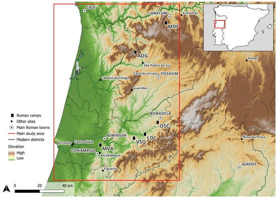
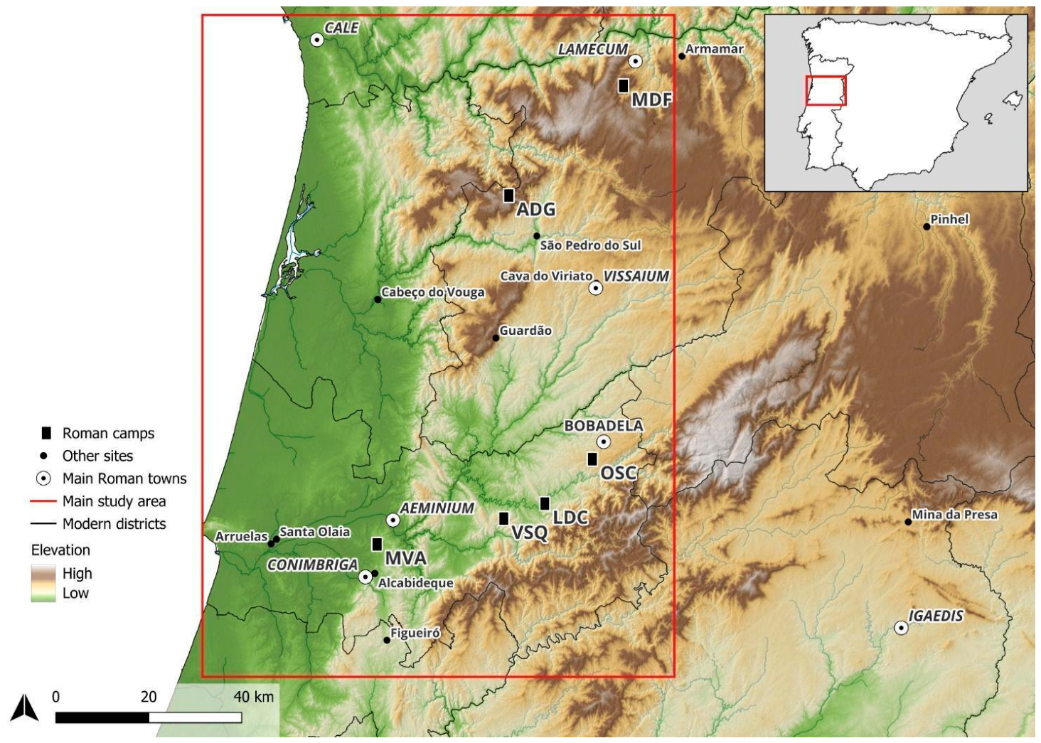
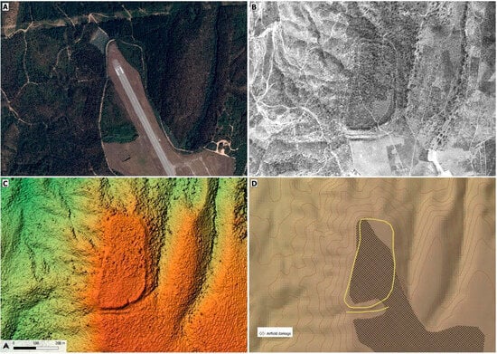
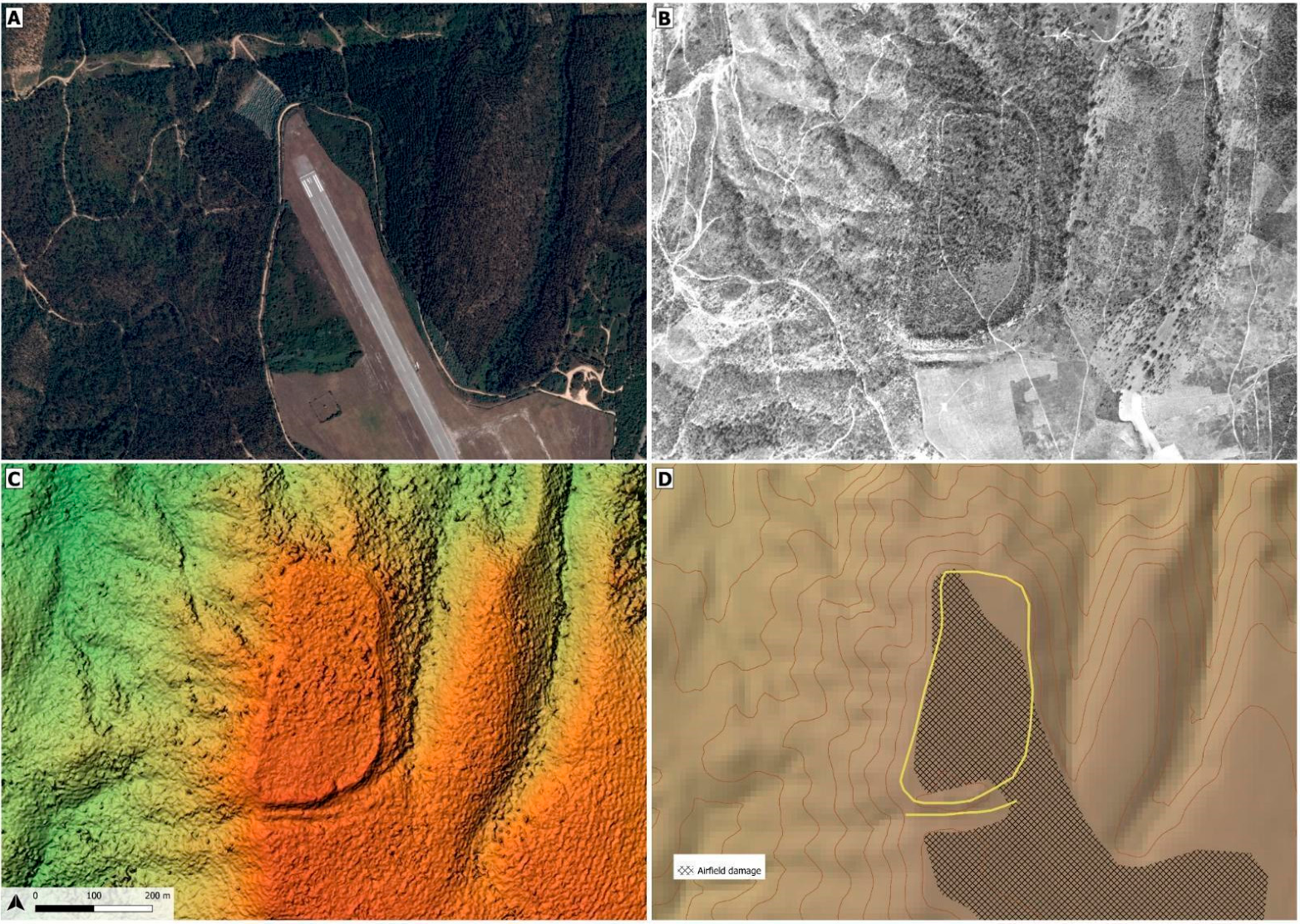
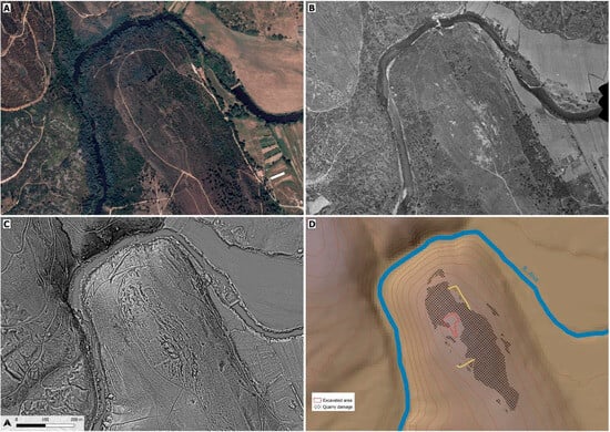
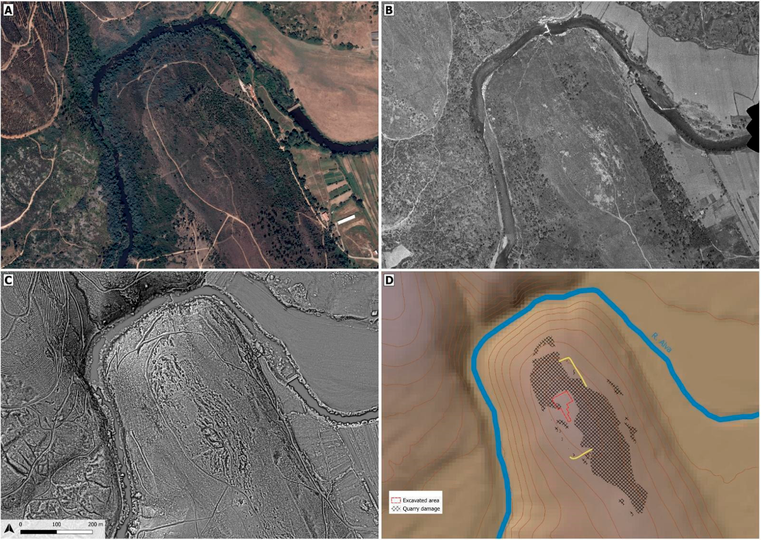
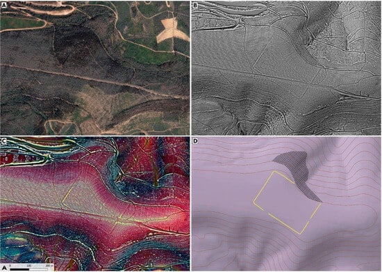
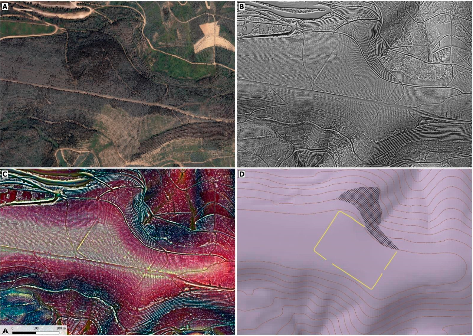
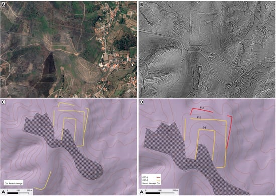
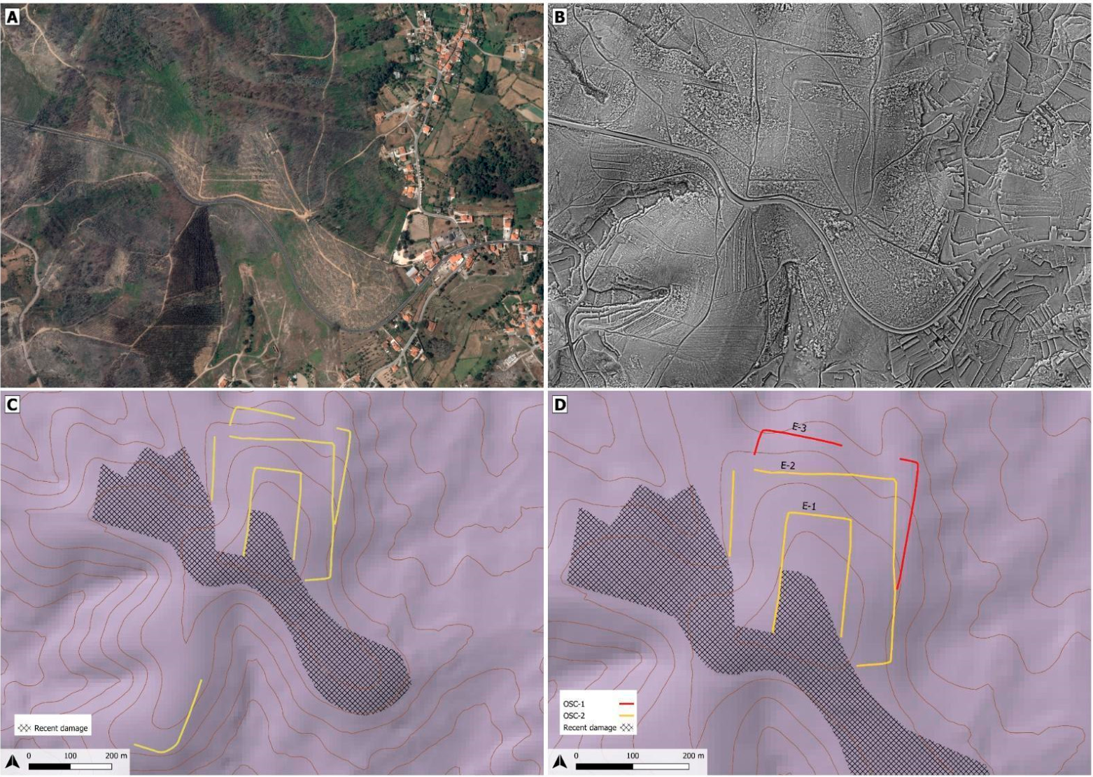
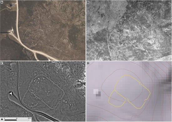
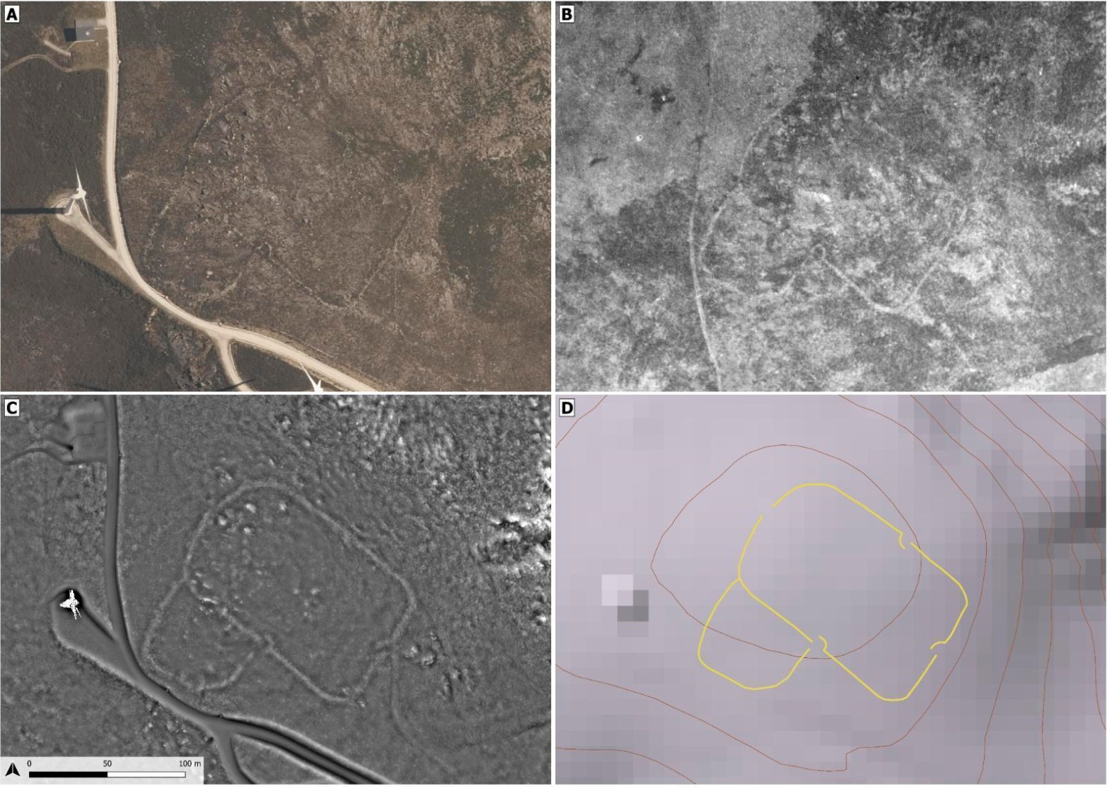
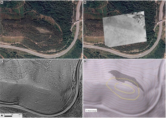
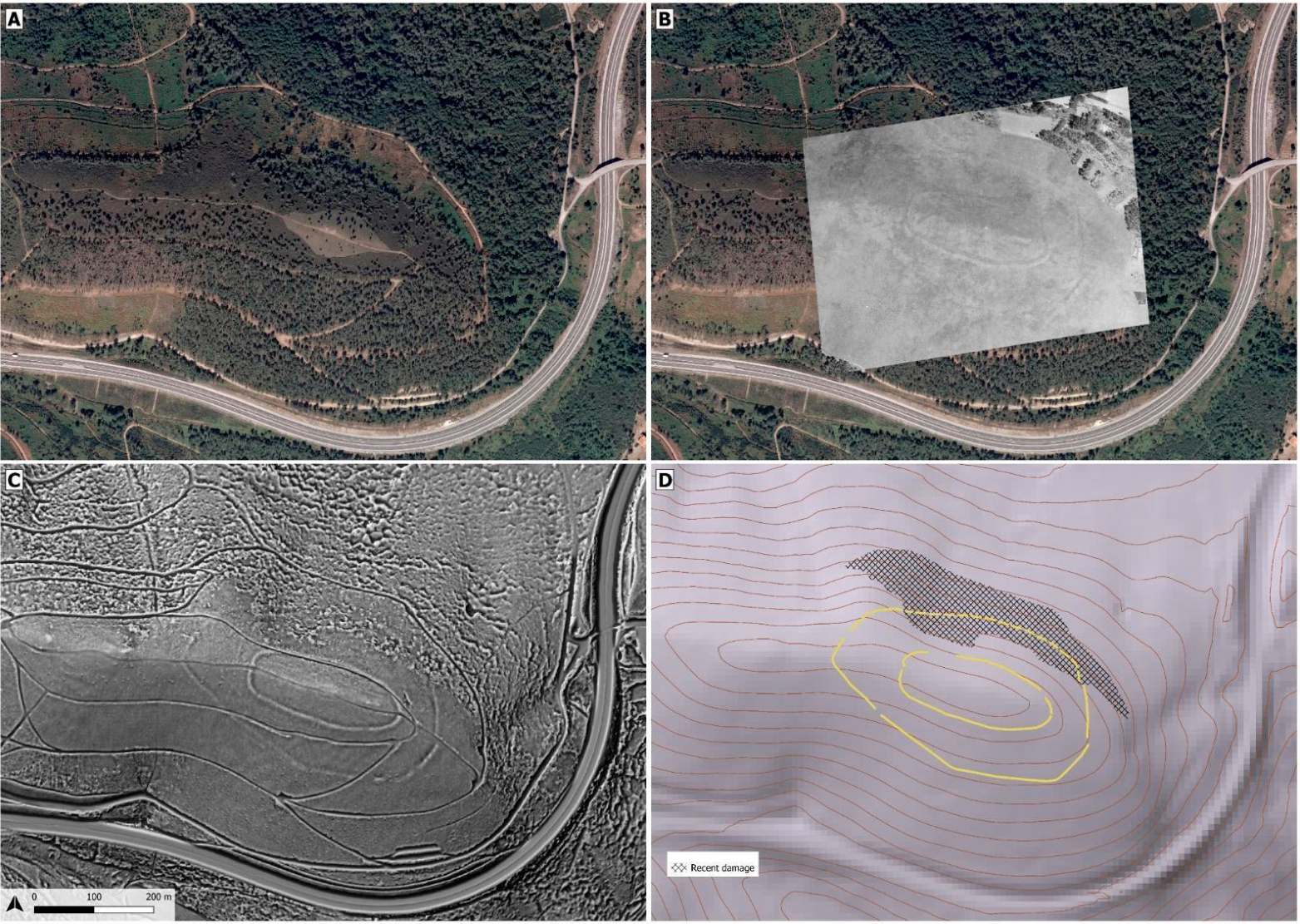
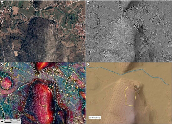
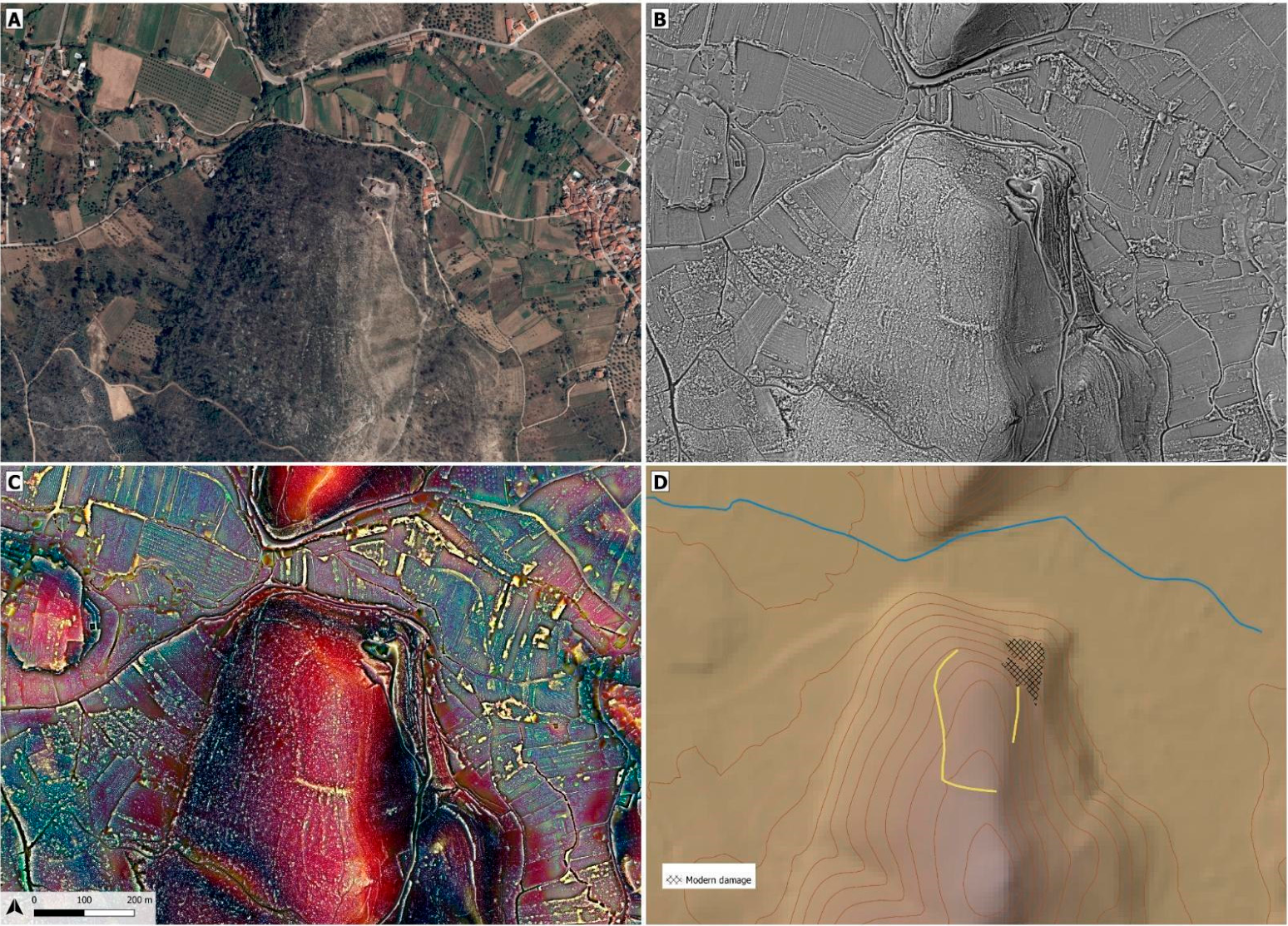
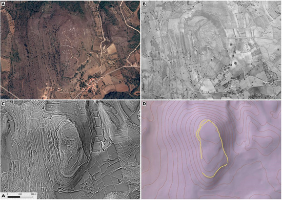
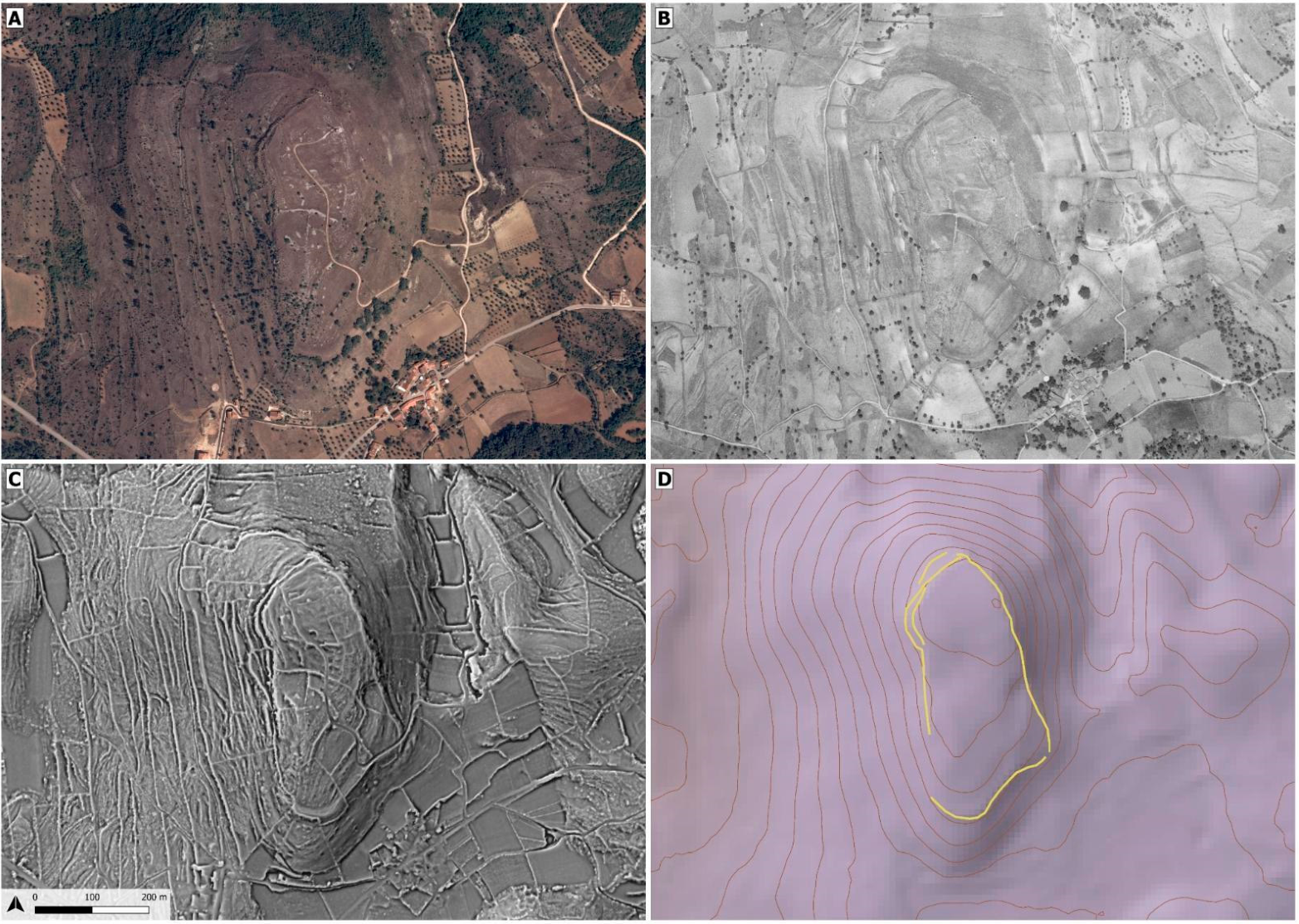
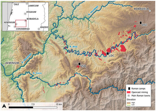
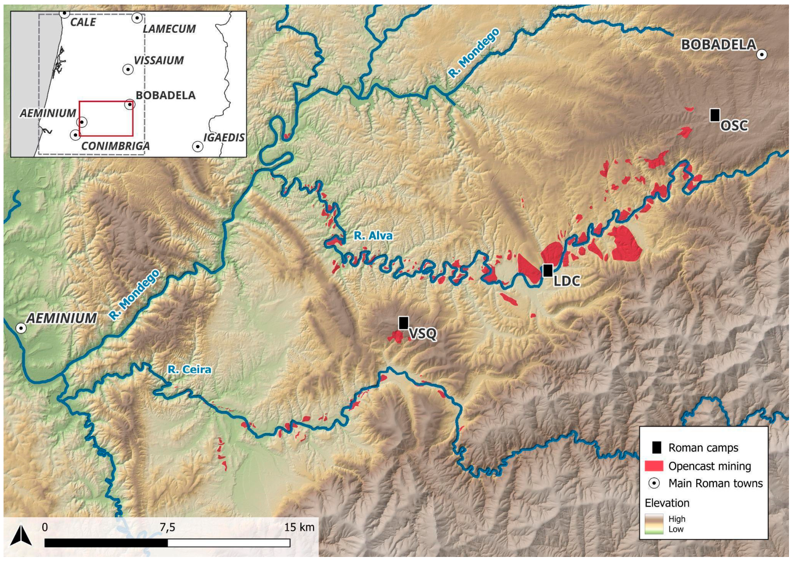
Disclaimer/Publisher’s Note: The statements, opinions and data contained in all publications are solely those of the individual author(s) and contributor(s) and not of MDPI and/or the editor(s). MDPI and/or the editor(s) disclaim responsibility for any injury to people or property resulting from any ideas, methods, instructions or products referred to in the content. |
© 2026 by the authors. Licensee MDPI, Basel, Switzerland. This article is an open access article distributed under the terms and conditions of the Creative Commons Attribution (CC BY) license.