


Abstract
High-rise building fires pose substantial challenges to conventional firefighting operations due to restricted rescue space and the difficulty of delivering suppression resources rapidly. To improve response efficiency, this study proposes a two-stage mission planning framework for multi-station UAV-based firefighting. The proposed methodology simultaneously accounts for environmental wind, building obstacles, fire evolution, and UAV payload constraints. In the first stage, an improved particle swarm optimization (PSO) algorithm is employed to generate time-optimal flight paths satisfying both spatial obstacle-avoidance and wind-field constraints. In the second stage, based on the actual flight times derived from the first stage, the multi-UAV resource scheduling problem is formulated as a mixed-integer linear programming (MILP) model to minimize the total fire suppression mission duration. Additionally, an isochrone-based firefighting coverage circle is introduced to optimize the layout of additional fire stations. Simulation results indicate that while optimized paths remain geometrically similar under varying wind conditions, wind-induced flight time variations significantly affect UAV arrival sequences and flight times. In the scheduling stage, differences in station layouts and fire scales alter projectile release timing; under unfavorable conditions, such temporal differences can increase the total mission duration by more than 28%. Notably, the optimized addition of fire stations effectively enhances response redundancy in high-rise clusters, reducing fire suppression time in adjacent scenarios by approximately 50%. The proposed method provides theoretical support and methodological guidance for cooperative UAV firefighting and emergency resource optimization in urban environments.
1. Introduction
With the continuous expansion of megacities worldwide, fires in high-rise and super-tall buildings have become increasingly frequent. Traditional high-rise firefighting operations face prominent limitations, including restricted rescue space, difficulties in deploying external equipment, and challenges in executing precise fire suppression. Because the rate of fire spread often outpaces the speed of rescue deployments, initial fires are difficult to control and extinguish effectively, often leading to severe casualties and massive property losses. As novel emergency response equipment, unmanned aerial vehicles (UAVs) have increasingly become a critical tool in high-rise firefighting due to their rapid response, high maneuverability, and capacity for close-proximity operations [1,2,3]. Currently, firefighting UAVs are mainly categorized into tethered and untethered types. The former are typically mounted on conventional fire trucks; although they offer extended operational endurance, their deployment is heavily constrained by urban traffic congestion and limited staging areas, which may delay the critical rescue window. In contrast, heavy-lift untethered UAVs can launch directly from distributed fire stations to the incident site, achieving rapid point-to-point response while circumventing ground traffic bottlenecks. Compared with conventional firefighting equipment such as ground fire engines and aerial ladder apparatus, untethered UAVs exhibit distinct operational advantages in high-density urban environments, where road access, ground staging space, and building façade accessibility are severely limited. This makes them particularly promising for early-stage fire suppression in high-rise buildings [4]. However, given the limited payload and extinguishing capacity of a single UAV, addressing high-rise fire scenarios necessitates multi-UAV collaborative operations. Translating dynamic fire suppression demands in physical space into a scientific multi-UAV task planning problem remains a core bottleneck restricting the practical application of this technology.
To address the aforementioned collaborative planning challenges, extensive explorations have been conducted primarily in typical scenarios such as post-disaster search and rescue. These studies largely focus on three aspects: trajectory planning, task allocation, and their joint optimization. In the field of trajectory planning, existing research primarily revolves around obstacle avoidance, energy consumption, and flight safety. Liu et al. [5] explored a four-dimensional trajectory planning method for manned/unmanned integrated airspace, effectively resolving spatiotemporal conflicts. Tao et al. [6] proposed an improved particle swarm optimization (PSO) path planning algorithm for 3D low-altitude urban environments, enhancing path generation efficiency in densely built areas. By comprehensively considering spatiotemporal constraints, trajectory conflicts, and collision avoidance, Saeed et al. [7] validated the effectiveness of swarm intelligence optimization algorithms and time-window routing models in multi-UAV collaborative path planning. Recent studies have further shown that wind-field characteristics can significantly affect UAV ground speed, waypoint selection, and time-optimal trajectory generation, indicating the necessity of incorporating wind disturbances into path-planning models. For instance, researchers have demonstrated that integrating wind vector models can significantly optimize flight paths and reduce the temporal cost of UAV missions [8]. Similarly, prevailing wind fields have been factored into routing algorithms to accurately evaluate UAV flight endurance and arrival sequences in emergency operations [9]. Nevertheless, these wind-oriented routing methods often simplify the environment into open airspace, while traditional urban obstacle-avoidance models frequently assume ideal calm-wind conditions. Although previous research has established a solid framework for individual path optimization, the coupled constraints of dense urban obstacle avoidance and wind-driven flight time variations remain insufficiently addressed in high-rise firefighting contexts. This limitation is further compounded by the fact that low-altitude trajectory feasibility in operational fire scenarios also depends on dynamic fire growth, creating a threefold coupling problem that existing models rarely capture holistically.
Regarding task allocation, multi-UAV systems require optimized scheduling based on scene resources and task types. Schwarzrock et al. [10] introduced swarm intelligence and multi-agent system approaches, proposing an improved heuristic algorithm to enhance the execution efficiency and completion rate of task allocation in multi-UAV collaborative missions. Peng et al. [11] proposed a task allocation model for UAV swarms in dynamic and uncertain environments, inspired by biological division of labor and coalition formation mechanisms. In highly time-sensitive scenarios such as emergency rescue, Alotaibi et al. [12] focused on optimizing multi-UAV task allocation and scheduling strategies in post-disaster situations, emphasizing decision-making efficiency under dynamic and resource-constrained conditions. Shen et al. [13] presented an aviation emergency rescue dynamic task allocation model based on multi-agent reinforcement learning. Addressing multi-objective optimization problems, Tang et al. [14] proposed a multi-task dynamic rescheduling model for heterogeneous multi-UAV systems based on swarm intelligence algorithms to improve task execution performance in complex environments. Li et al. [15] developed a multi-objective, multi-population self-adaptive ant lion optimization algorithm to solve multi-task allocation for multi-UAV systems under multiple constraints. Han et al. [16] established a multi-objective optimization model for multi-UAV collaboration in earthquake search and rescue missions.
Despite these advancements, for heavy-lift UAV firefighting missions in urban high-rise environments, existing models still struggle to fully adapt to physical constraints such as dynamic fire evolution and payload matching for suppressant delivery. Most methods fail to effectively couple the dynamic growth characteristics of fires over time, while static task allocation mechanisms often lead to a disconnect between rescue resource deployment and actual firefighting demands. Furthermore, current allocation strategies rarely establish a precise correspondence between fire intensity and UAV effective payload, often resulting in over-delivery or under-delivery of extinguishing agents and low resource utilization. Additionally, most current research assumes that UAVs depart from a single base, lacking a multi-site collaborative scheduling framework. This makes it difficult to fully leverage the rapid response and resource complementarity advantages of distributed urban fire stations.
Meanwhile, to address the highly coupled nature of task allocation and trajectory planning during actual mission execution, some scholars have begun to focus on the joint optimization of these two components, which can be mainly divided into unified solving and two-stage solving strategies. Research adopting the unified solving strategy tends to conduct global optimization under the same framework by constructing a joint objective function and introducing improved intelligent optimization algorithms, balancing constraint feasibility with overall system performance. For instance, Yan et al. [17] achieved unified optimization of multi-UAV task allocation and trajectory planning via an improved genetic algorithm, effectively addressing collaborative mission problems in multi-objective, multi-constraint scenarios. Papaioannou et al. [18] proposed a unified framework for UAV 3D search planning capable of automatically generating collision-free search trajectories satisfying mission constraints in emergency environments, thereby improving target localization accuracy and task execution efficiency. Nevertheless, such methods entail high computational complexity, making it difficult to meet the rapid response requirements of firefighting emergencies.
By contrast, the two-stage solving strategy decomposes the UAV collaborative mission problem into two relatively independent sub-problems, namely task allocation and trajectory planning, thereby reducing the problem scale and computational complexity. For example, Melhim et al. [19] and Xiong et al. [20] adopted a “task allocation first, path planning later” strategy for forest fire detection, maritime delivery, and 3D disaster rescue scenarios, respectively, verifying the effectiveness of this methodology in complex environments. However, these traditional sequential methods often defer detailed path planning to the later stage, causing the initial task allocation to disconnect from realistic spatiotemporal constraints. Particularly for firefighting operations, recent advancements have coupled fire characteristics or risk maps with path optimization [21,22,23], which explicitly discuss how low-altitude urban flight paths are physically restricted by dynamic hazards such as rapid fire spread and vertical thermal draft variations. For instance, researchers have developed chance-constrained risk-aware planning [21], GMM-RSOM patrol route optimization [22], and deep reinforcement learning-based trajectory generation [23]. Nevertheless, these methods are primarily tailored for fire monitoring and reconnaissance. They still fail to adequately address multi-station collaborative resource scheduling and neglect the deteriorating impact of actual flight times on fire development dynamics during active suppression missions.
In summary, current research mostly focuses on the application of light and small UAVs in typical scenarios such as emergency rescue, with systematic explorations spanning trajectory planning, task allocation, and joint optimization, yielding various intelligent optimization algorithms and strategies. Nevertheless, heavy-lift UAV fleets for high-rise fire suppression remain largely underexplored. Existing optimization formulations encounter notable scalability and feasibility limitations when simultaneously subjected to dense high-rise obstacles, environmental wind disturbances, dynamic fire development, and multi-UAV payload constraints. To address this gap, this paper proposes a two-stage coupled task planning method for collaborative firefighting in high-rise buildings, with the minimization of total mission duration as the primary optimization criterion. In the first stage, an improved particle swarm optimization (PSO) algorithm generates time-optimal collision-free trajectories under spatial obstacle avoidance and wind field constraints. In the second stage, the collaborative scheduling problem is formulated as a linear programming model that integrates dynamic fire evolution and payload capacity constraints to obtain the optimal suppressant allocation scheme across multi-station UAVs. This work provides a methodological framework for the cooperative deployment of firefighting UAVs in urban high-rise environments.
To clearly summarize the academic value of this study, three main contributions are highlighted. First, a two-stage collaborative fire suppression model tailored for multiple UAV operations in high-rise buildings is established, whereby the joint mission is successfully decomposed into independent path generation and resource scheduling subproblems. Second, the impacts of environmental wind fields, spatial obstacle avoidance, and fire scales are quantified by the proposed framework, allowing the spatiotemporal coupling between external environmental factors and cooperative UAV delivery efficiency to be effectively captured. Third, an isochrone-based coverage probability is established to quantify spatial firefighting coverage, which is subsequently integrated into a location optimization framework to systematically determine the layout of newly added fire stations. Consequently, a theoretical foundation and methodological guidance for the collaborative application of firefighting UAVs in high-rise buildings are provided by this study.
2. Task Scenario Description and Model Formulation
2.1. Urban Geographic Information Extraction and Spatial Layout
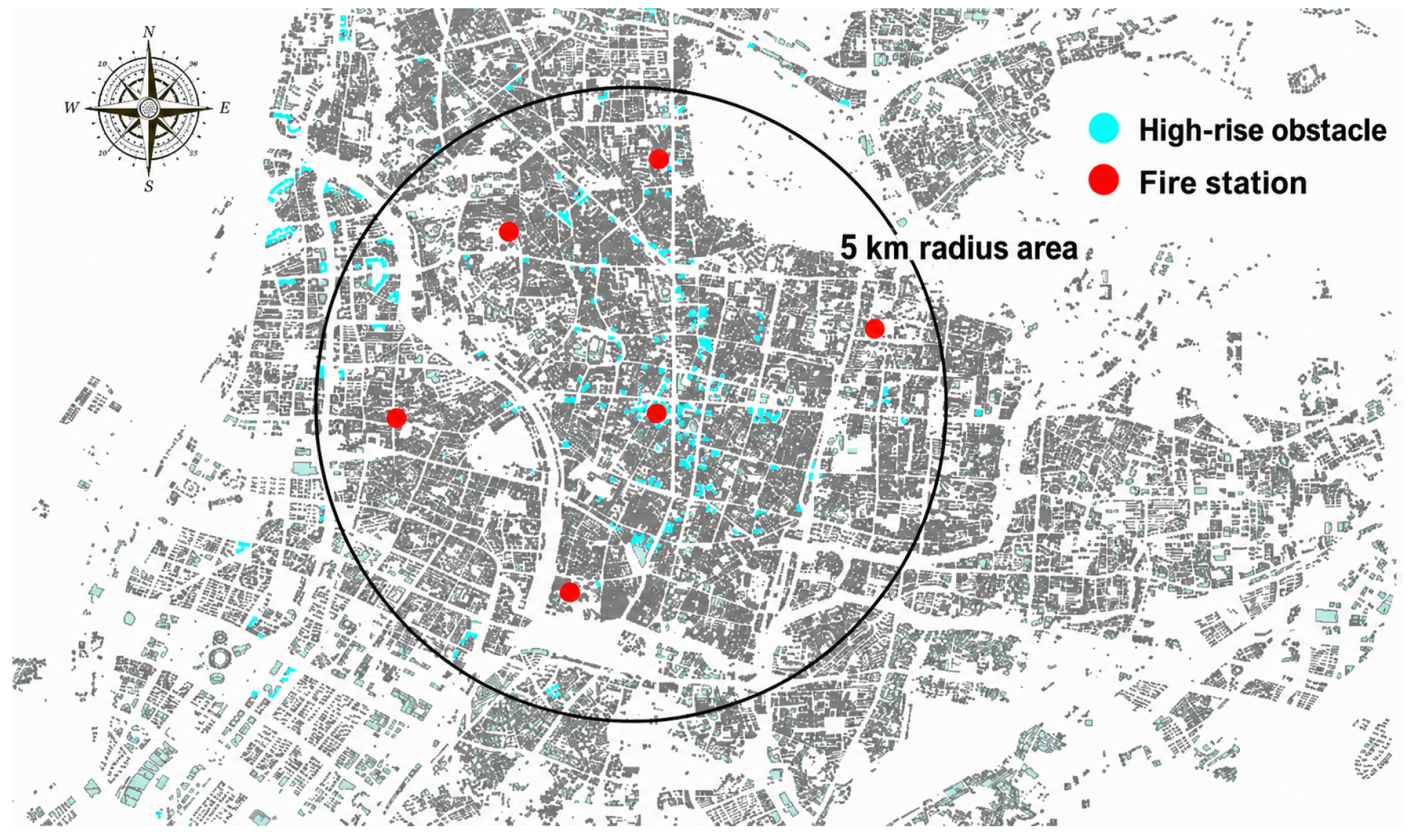
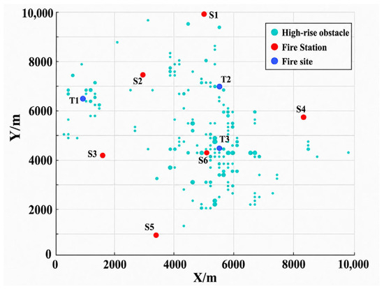
To construct a realistic scenario for UAV-based fire suppression in high-rise buildings, this study selects a representative urban area and develops a two-dimensional spatial model based on the geographical distribution of regional fire stations and high-rise buildings, as shown in Figure 1. The key spatial elements are extracted as follows.
Figure 1.
Spatial layout of high-rise buildings and fire stations in the study area.
- (1)
- High-rise building nodes: Basic building data for the selected area are obtained, and residential buildings with heights greater than 27 m are extracted using ArcGIS 10.6. These buildings are treated as high-rise obstacles in the path-planning model and are represented by light-blue blocks in Figure 1.
- (2)
- Fire station nodes: Six major fire stations in the study area are identified and used as the initial locations for UAV takeoff, landing, and dispatching. These stations are represented by red circular markers in Figure 1.
- (3)
- Integrated spatial layout: The geographical information of high-rise buildings and fire stations is projected into a unified two-dimensional coordinate system, thereby forming a digital spatial map for multi-station cooperative fire suppression.
2.2. Problem Description
When a fire occurs in a high-rise building within the study area, UAVs are dispatched from distributed surrounding fire stations to the fire location for cooperative fire suppression. The optimal mission plan is mainly determined by two components, which are the UAV flight paths from fire stations to the fire location and the duration of the fire suppression operation. UAV path planning is affected by environmental wind, UAV performance parameters, the distance between each fire station and the fire location, and the spatial distribution of high-rise buildings treated as obstacles along the flight path. The fire suppression duration is influenced by the fire scale, the arrival sequence of UAVs, the release timing of extinguishing projectiles, and the suppression effectiveness of each projectile. Therefore, the objective is to determine an optimal mission plan that minimizes the total time required for all dispatched UAVs to complete the fire suppression task. This problem is solved in two stages.
In the first stage, the time-optimal collision-free flight trajectory from each distributed fire station to the fire location is computed independently. Since UAVs departing from different stations encounter different obstacle distributions in terms of number, size, and spatial layout, and because their flights are affected differently by the environmental wind field, the resulting obstacle-avoidance trajectories and corresponding flight durations differ across stations. In the second stage, the optimal flight times derived from the first stage serve as deterministic input parameters. A mixed-integer linear programming (MILP) model is formulated to solve the multi-UAV cooperative scheduling problem, which simultaneously determines the dispatch status of each UAV and the precise projectile release timing for deployed units. The objective is to minimize the total fire suppression mission duration.
To facilitate model formulation while reflecting practical fire suppression operations, the following assumptions are made:
- (1)
- Each fire station is equipped with one heavy-lift firefighting UAV, and fire suppression is performed by hovering and releasing extinguishing projectiles;
- (2)
- All obstacles encountered during UAV flight are high-rise buildings;
- (3)
- All UAVs and the extinguishing projectiles they carry have identical performance parameters;
- (4)
- The effects of payload variation and energy consumption during UAV operation are neglected, and each UAV maintains a constant cruising speed during flight;
- (5)
- Each UAV releases its first extinguishing projectile immediately after arriving at the fire location, and hovering-based projectile release operations are independent and non-interfering;
- (6)
- All extinguishing projectiles are assumed to possess a uniform suppression capacity, where the highly complex physicochemical fire suppression process is mathematically abstracted as an instantaneous decay.
These simplifications are adopted to focus the analysis on macro-level resource delivery timelines rather than micro-scale transport phenomena or transient droplet interactions. Specifically, abstracting away battery degradation, payload-dependent aerodynamic drag, and buoyancy-driven thermal effects is essential to preserve structural linearity and computational tractability in the mixed-integer linear programming (MILP) formulation. This approach is consistent with established macro-level fleet routing methodologies [24,25,26] and ensures system scalability for multi-station collaborative scheduling under emergency time constraints. Moreover, the resulting model provides a theoretically consistent foundation upon which higher-fidelity trajectory and control refinements can be built in subsequent work.
2.3. Model Formulation
Let the set of UAV indices be defined as , where denotes the -th UAV. Let the set of obstacle center coordinates be denoted as . For any obstacle , its center coordinate is denoted as . In the model coordinate system, distance is measured in kilometers and time is measured in seconds.
A two-stage objective function is established as follows:
2.3.1. Path-Planning Stage
In the first stage, the objective is to minimize the flight path length of each UAV from its fire station to the fire location:
where represents the total number of path segments within the flight trajectory. The variables , and denote the path penalty coefficient, the geometric segment length, and the ground speed of UAV within the segment connecting nodes and , respectively. and denote the horizontal and vertical coordinates of the path node of UAV, respectively. , and denote the ground speed of UAV , the airspeed of UAV , and the environmental wind speed, respectively. , and denote the corresponding direction angles.
During the path-planning stage, each UAV must avoid all high-rise buildings treated as obstacles in the two-dimensional space. In this study, each obstacle is represented by an equivalent control circle. Each equivalent control circle is constructed from the two-dimensional building footprint represented in the case-study obstacle map. For an individual building, the geometric center of its footprint is taken as the circle center, and the maximum distance from this center to the footprint boundary is used as the basic equivalent radius, thereby conservatively enclosing the building footprint. For large or irregular building clusters, multiple circles are used, and the union of these circles conservatively covers the corresponding building footprint. To ensure flight safety, neither the UAV path nodes nor the connecting path segments are allowed to intersect the effective control region of any obstacle. Therefore, the path penalty coefficient is introduced as follows:
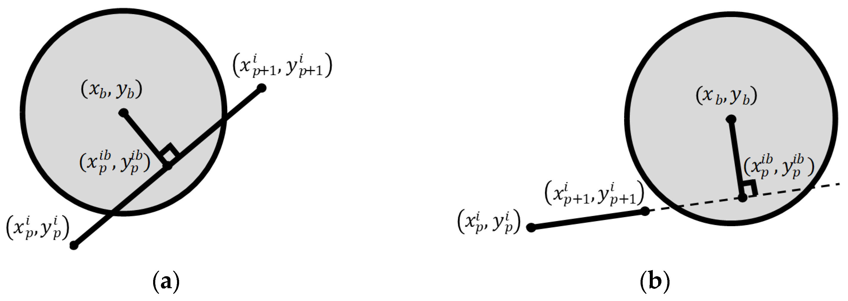
where M is a sufficiently large positive constant. K, defined in Equation (5), represents the inner product between the vector from to and the vector from to . The coordinates ), given in Equations (6) and (7), denote the foot of the perpendicular from the obstacle center ) to the line determined by the adjacent path nodes to . The coefficients defining this line are given by , , . The variable , defined in Equation (8), denotes the perpendicular distance from the obstacle center to the aforementioned line segment, while is the Euclidean distance from the path node to the obstacle center. The variable represents the effective control radius of obstacle , which is obtained by adding a fixed 20 m planning buffer to the basic equivalent radius of the building footprint. This inflated obstacle boundary strategy successfully accounts for the physical dimensions of the heavy lift aerial platform, inherent navigation positioning errors, and geometric modeling uncertainties. Furthermore, this safety margin serves as a vital conservative buffer to mitigate cross-track errors and path tracking deviations induced by unresolved wind gusts or localized aerodynamic turbulence within dense high-rise urban canyons [27,28]. In Equation (4), the condition indicates that two adjacent path nodes are both located outside the circular obstacle region. The condition implies that the distance between the connecting path segment and the obstacle center is smaller than the radius, indicating a potential collision risk. When and K > 0, the line segment connecting two adjacent path nodes intersects the obstacle region, as shown in Figure 2a. The condition indicates that at least one of the two adjacent path nodes lies within the obstacle control region.
Figure 2.
Geometric schematic of obstacle-avoidance parameters. (a) Contact. (b) No contact.
In addition to the obstacle-avoidance constraints, the flight endurance of each UAV is limited by . The endurance constraint is expressed as
where is the flight time of UAV , represents the shortest feasible flight path length from the fire station to the fire location, and denotes the average cruising speed along the flight path. The endurance constraint in Equation (10) assumes a constant average power consumption rate for both cruising and hovering phases. In practice, however, heavy-lift UAVs experience gradual payload reduction as extinguishing agents are discharged, which lowers total aircraft mass and consequently improves the power-to-weight ratio, flight stability, and thrust margins. On a separate note, battery energy dissipation during hovering is inherently nonlinear and sensitive to local aerodynamic disturbances. To preserve computational tractability in the multi-station cooperative scheduling framework, these transient effects are abstracted as a conservative static limit.
2.3.2. Scheduling Optimization Stage
In the second stage, the UAV scheduling is optimized to minimize the total mission duration, which spans from the departure of the first UAV to the final suppression of the fire. The objective is expressed as
where represents the overall completion time of the fire suppression mission, defined as the longest execution time among all dispatched UAVs. The parameter denotes the time interval between consecutive releases of extinguishing projectiles by the same UAV, and is the number of extinguishing projectiles actually released by UAV . ∈ {0, 1} is a binary decision variable, where if UAV is dispatched, and 0 otherwise. The term represents the sum of the flight time and projectile release duration of UAV , corresponding to its total mission execution time.
During the UAV scheduling stage, the final fire suppression time is defined as the release time of the last extinguishing projectile that suppresses the fire. The relevant constraints are given as follows:
where and are the maximum effective payload capacity of the UAV and the weight of a single extinguishing projectile, respectively. represents the heat release rate of the fire when the first UAV arrives. denotes the total number of extinguishing projectiles required to suppress the fire at this scale, and is the effective suppression capacity of a single extinguishing projectile. In the computational implementation using the PuLP toolkit, is defined as a binary dispatch variable, is a nonnegative integer variable, and is treated as a continuous overall completion time variable. To maintain structural linearity and computational tractability, the nonlinear behaviors in Equations (12) and (16) are mathematically converted into equivalent linear constraints using a standard big M formulation and linear linking inequalities, thereby allowing the scheduling model to be solved as a standard mixed integer linear programming model.
3. Algorithm Design
3.1. Adaptive Particle Swarm Optimization with Advanced Learning
Particle swarm optimization (PSO), originally proposed by Kennedy and Eberhart, is a population-based stochastic optimization algorithm that has been widely applied to nonlinear and constrained optimization problems because of its simple structure and global search capability [26]. However, the standard PSO algorithm uses fixed parameters. During the iterative optimization process, if the individual cognitive component dominates the social component, the algorithm may fail to converge in the later stage. Conversely, if the social component dominates too strongly, the algorithm may converge rapidly but become trapped in a local optimum, thereby failing to obtain the global optimum. To address this limitation, this study adopts an adaptive particle swarm optimization (APSO) algorithm, in which the algorithmic parameters are dynamically adjusted according to the convergence state of the swarm. In addition, an opposition-based learning (OBL) strategy and dynamic parameter adjustment strategies are introduced to improve global search capability and overall optimization performance [29]. By integrating opposition-based learning and dynamic parameter adjustments, this improved variant achieves superior convergence stability and trajectory feasibility over standard particle swarm optimization. Specifically, opposition-based initialization prevents premature convergence, while cosine-based inertia weights and adaptive learning factors balance exploration and exploitation under dense high-rise obstacles and wind field disturbances. Because the optimization stability and search precision of this hybrid paradigm have been thoroughly validated across typical benchmark functions in existing literature [30,31,32], conducting repetitive algorithmic baseline evaluations is omitted in this work. This study directly applies these established mathematical components to focus on domain-specific constraint handling, coupled variables, and parameter calibration for collaborative multiple UAV fire suppression operations.
3.1.1. Population Initialization Based on Opposition-Based Learning
The search efficiency and solution quality of the algorithm largely depend on the distribution of the initial population. A high-quality initial population can improve the coverage of the search space, reduce the probability of being trapped in local optima, and provide a reliable foundation for subsequent iterations. Therefore, an opposition-based learning (OBL) scheme is introduced during population initialization. For each particle in the population, a corresponding opposite particle is generated. The fitness values of the original particle and the opposite particle are then compared, and the particle with the better fitness value is retained. If the opposite particle yields a lower fitness value, it replaces the original particle; otherwise, the original particle is retained. This strategy improves the overall quality of the initial population, accelerates convergence, and enhances the optimization performance of the algorithm. The opposition-based learning strategy is defined as follows. In a -dimensional search space, let the position of a particle be , where . The corresponding opposite particle is defined as , where . The fitness values of the original particle and the opposite particle are denoted as and , respectively. If , then replaces ; otherwise, is retained.
3.1.2. Improved Inertia Weight
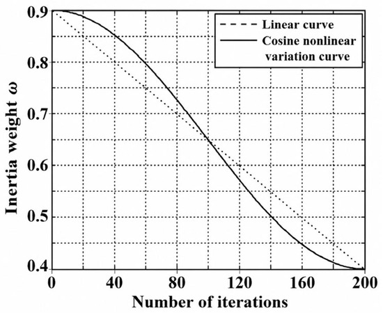
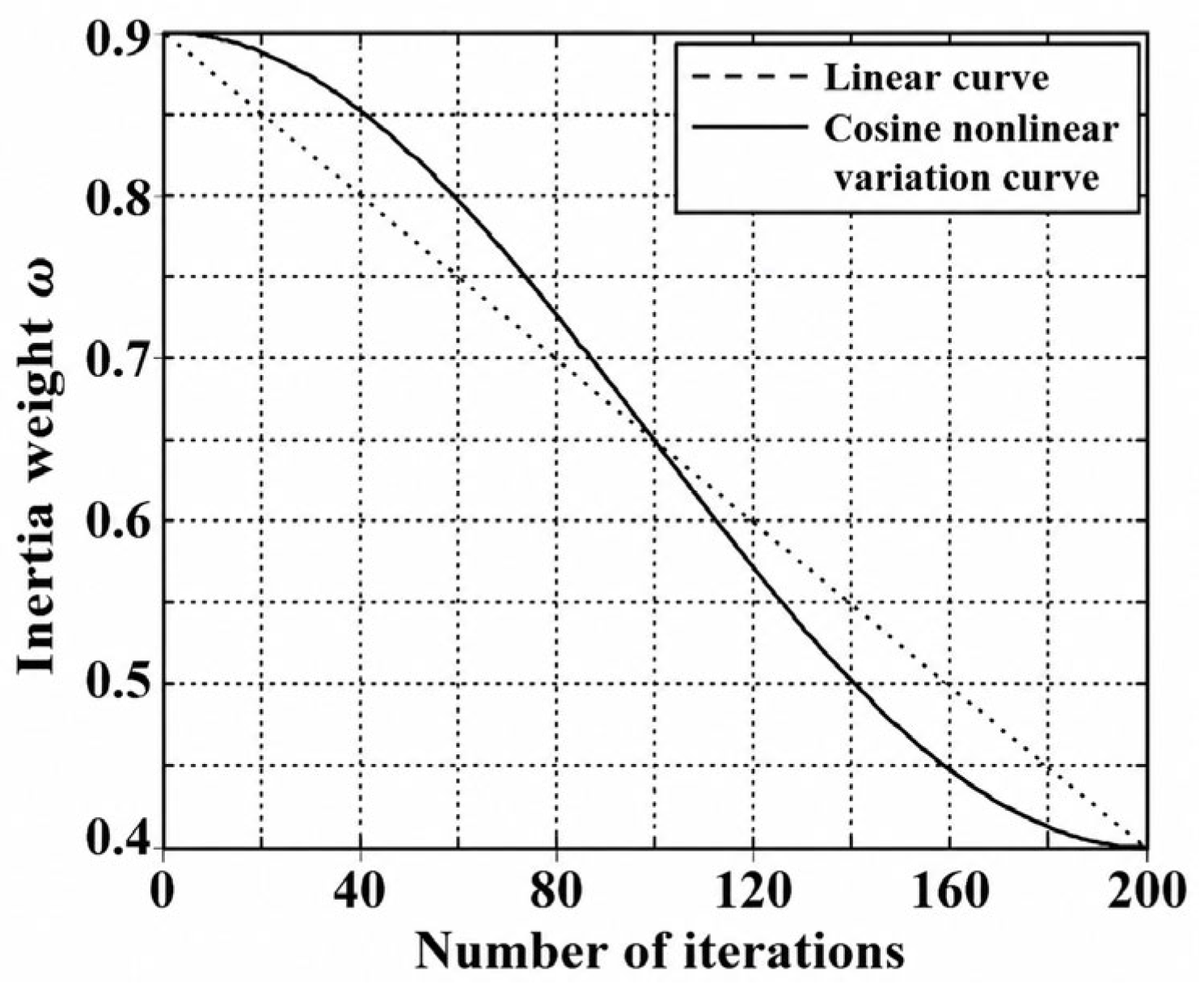
The balance between global exploration and local exploitation is strongly affected by the inertia weight . A larger value of enhances the global search capability of the algorithm, allowing particles to explore a wider search space. In contrast, a smaller value of improves local exploitation, enabling particles to refine solutions within promising regions. To maintain strong global exploration in the early iterations and improve solution accuracy in the later iterations, a slowly varying inertia weight strategy is adopted. This strategy helps prevent premature convergence in the early stage while ensuring sufficient local refinement in the later stage. The inertia weight [33], first introduced to balance global exploration and local exploitation in PSO, is updated as follows.
where and denote the maximum and minimum inertia weights, respectively; denotes the current iteration number; denotes the maximum number of iterations; and denotes the inertia weight at iteration , as shown in Figure 3.
Figure 3.
Variation curve of the inertia weight .
3.1.3. Improved Learning Factors
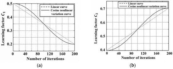
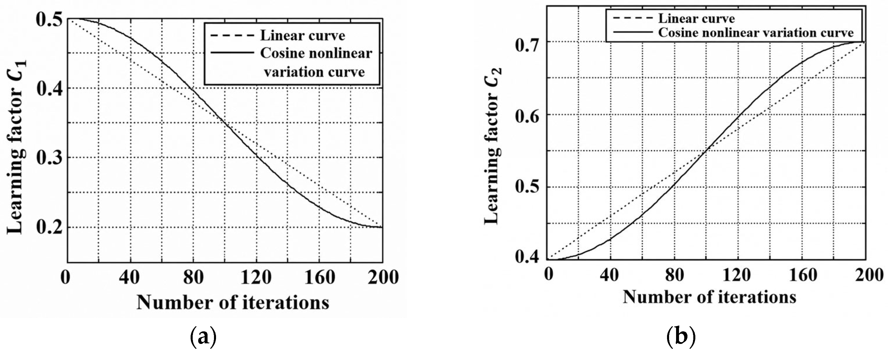
In PSO, the dynamic balance between the cognitive learning factor and the social learning factor is essential for maintaining robust search performance. Building upon the classic concept of time-varying acceleration coefficients [34], this study introduces an adaptive cosine-based update strategy. During the early stage of iteration, a relatively large and a relatively small are assigned to maximize global exploration. As the iteration proceeds, nonlinearly decreases while gradually increases, thereby preventing premature convergence and effectively guiding the particles toward the global optimum. The mathematical formulations of these update rules are as follows:
where and denote the upper and lower bounds of the cognitive learning factor , respectively; and denote the upper and lower bounds of the social learning factor , respectively. The variation curves of and during the iterative process are shown in Figure 4.
Figure 4.
Variation curves of the applied learning factors. (a) Cognitive learning factor . (b) Social learning factor .
3.2. Solution Procedure of the Model
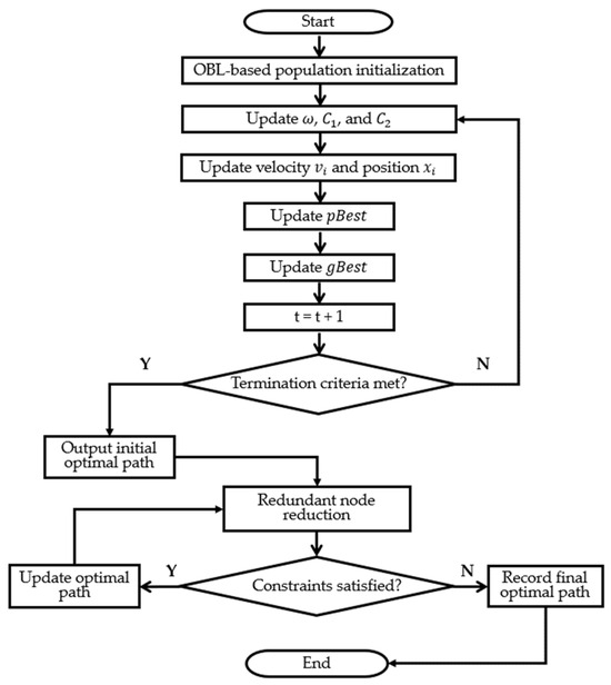
The proposed method consists of two stages: UAV path planning and task scheduling. In the first stage, the improved PSO algorithm is used to determine the shortest feasible flight path for each UAV. The overall procedure is shown in Figure 5 and described as follows.
Figure 5.
Flowchart of the proposed PSO-based path-planning algorithm.
3.2.1. Particle Swarm Initialization and Parameter Setting
The swarm size, the number of discrete path nodes—namely, the particle dimension—and the maximum number of iterations, are specified. The extreme values of the parameters , and are initialized. Environmental wind parameters are then introduced, and the path nodes and velocities of all particles are initialized. The fitness value of each particle in the initial population is calculated, where the fitness value corresponds to the flight time along the path. The individual historical best solution and the global historical best solution are then recorded. Subsequently, OBL is performed to compare the original particles with their corresponding opposite particles, and the better particles are retained to generate a high-quality initial population.
3.2.2. Iterative Optimization
Following swarm initialization, the optimization loop executes iteratively until the termination criteria are satisfied. In each iteration, the fitness of each particle is evaluated based on its current path node coordinates. Both the personal best (pbest) and global best (gbest) positions are updated if the newly computed fitness outperforms their corresponding historical values. Subsequently, the inertia weight and acceleration learning factors are modified via the cosine update strategy before updating the velocity and spatial position vectors of the entire particle population.
3.2.3. Path Node Refinement
After the PSO iteration is completed, the optimized path nodes of each UAV are obtained. To simplify the flight path, redundant nodes are removed and the remaining nodes are reconnected, while ensuring that the simplified path still satisfies the obstacle-avoidance constraints. The resulting node sequence is then used as the final feasible flight path.
In the second stage, the UAV scheduling problem is formulated as a multi-station dispatching optimization problem. To address the inherent quadratic constraints, auxiliary variables are introduced to linearize the model, thereby transforming it into a standard MILP format. Subsequently, the PuLP optimization toolkit in Python [35] is employed to computationally solve the MILP model, yielding an optimal UAV collaborative scheduling strategy that minimizes the total fire suppression mission duration.
4. Results and Analysis
4.1. Parameter Settings
4.1.1. Spatial Layout of the Task Scenario
A representative dense high-rise urban area is used as the case study area, where numerous high-rise buildings are treated as obstacles and multiple fire stations are distributed. It is assumed that when a sudden fire occurs in a high-rise building, UAVs are dispatched from nearby fire stations to the fire location according to the fire suppression demand, and each UAV must avoid obstacles during flight.
As shown in Figure 6, a 10,000 m × 10,000 m planar coordinate system is adopted to represent geographical space. Dense building clusters are represented by individual or combined equivalent control circles constructed according to the procedure described in Section 2.3, such that the corresponding building footprints are conservatively covered. Based on the actual layout of the study area, six fire stations and three representative fire locations are identified. The specific coordinates are designated as S1 (5000, 10,000), S2 (2800, 7450), S3 (1600, 4200), S4 (8300, 5800), S5 (3400, 1000) and S6 (5100, 4300) for the fire stations, and T1 (970, 6500), T2 (5500, 7000) and T3 (5500, 4500) for the fire locations. These target points are spatially dispersed and feature highly differentiated surrounding obstacle densities and geometric orientations relative to the departure bases. Such a heterogeneous arrangement allows for a robust analysis of the overall mission planning framework against environmental wind fields, obstacle layouts, and varying flight distances. Although this scenario configuration serves as a representative topological exploration rather than a statistically exhaustive sampling, it successfully isolates distinct spatial accessibility profiles. Consequently, the performance metrics and variations reported in subsequent sections represent specific baseline operational outcomes under these controlled benchmark settings, which are intended to elucidate the system-level mechanics and scheduling logic of the proposed multi-UAV framework rather than generalized universal statistical averages.
Figure 6.
Spatial distribution of fire stations, fire sites, and obstacles.
4.1.2. Parameters of Heavy-Lift Firefighting UAVs
Referring to the technical specifications of current mainstream heavy-lift firefighting UAVs, all fire stations are assumed to be equipped with UAVs with identical parameters. These configurations are selected with reference to representative commercial heavy lift multirotor platforms, such as the Acecore Noa active fleet specifications [36]. The cruising speed is set to 20 m/s, the maximum payload capacity is 20 kg, the endurance time is 50 min, and the release interval between consecutive extinguishing projectiles is 35 s. This identical parameter setting serves as a baseline homogeneous configuration to verify the logical consistency and computational feasibility of the proposed two-stage mission planning framework. By isolating individual vehicle performance variability, this controlled baseline effectively decouples and highlights the systemic effects of environmental wind vectors, localized high-rise obstacles, and multi-station collaborative resource allocation constraints on the overall firefighting mission duration. While real-world operations involve parameter fluctuations, establishing such a standardized fleet profile is a standard practice in mission-level scheduling research to validate foundational algorithmic structures.
4.1.3. Parameters of Onboard Extinguishing Projectiles
According to firefighting equipment specifications, the mass fraction of extinguishing agent in the total mass of an extinguishing projectile generally ranges from 40% to 60%. In this study, this fraction is set to 50%. Therefore, the total mass of a single extinguishing projectile is 5 kg, including 2.5 kg of extinguishing agent [37]. Accordingly, each UAV can carry four extinguishing projectiles at full load.
4.1.4. Parameters of Environmental Wind Conditions
The selected city has a monsoon climate, and the prevailing wind direction varies seasonally. Easterly and southeasterly winds are dominant in spring and summer, whereas northeasterly winds prevail in autumn and winter. Therefore, three environmental wind conditions are defined for comparative analysis, as shown in Table 1.
Table 1.
Parameters of the three environmental wind conditions.
4.1.5. Fire Development Parameters
The fire growth in high-rise buildings is assumed to follow a fire-growth model [38]. The fire growth coefficient is set to , and the ignition time is set to . The fire suppression control coefficient of the extinguishing agent is set to .
4.1.6. Algorithm Parameter Settings
To ensure efficient convergence, the particle swarm size is set to 30, the number of UAV path nodes is set to 80, and the maximum number of iterations is set to 200. The bounds of the inertia weight are set to and . The bounds of the learning factors are set to , , , and . The wind speed is set to , and the wind-direction angle is set to .
4.2. Simulation Results and Discussion
4.2.1. Feasibility Analysis of the Algorithm
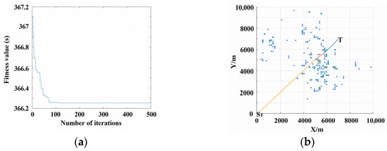
To evaluate the feasibility of the obstacle-avoidance path-planning algorithm, a benchmark test is conducted along a trajectory using a path from the starting point to the target point . This specific route traverses the densest obstacle cluster under a crosswind condition, thereby effectively verifying both the collision-avoidance capability of the algorithm and the accuracy of the wind correction model. Executed within a MATLAB computational environment, the fitness convergence curve and path-planning visualization are illustrated in Figure 7a and Figure 7b, respectively. Specifically, the optimization engine achieves stable convergence within approximately 75 iterations, yielding an optimal flight time of roughly 366 s, while the corresponding spatial profile exhibits a simplified and smooth flight path that successfully clears all building boundaries. These foundational findings validate the viability of the path-planning framework under wind-field constraints. While this single isolated trajectory serves as an initial baseline verification to explicitly visualize the underlying convergence mechanics, the algorithmic robustness across diverse geometric configurations is extensively evaluated through the comprehensive mission scenarios detailed hereafter. Throughout the multi-station collaborative firefighting simulations presented in the subsequent sections, dozens of distinct collision-free trajectories are dynamically generated and executed under varying wind fields, which confirms the safe-maneuvering consistency of the framework under complex and stochastic urban layouts.
Figure 7.
Algorithmic verification profiles of the benchmark routing case. (a) Fitness convergence curve. (b) Spatial visualization of the path solution.
4.2.2. Influence of Environmental Wind on UAV Path Planning
To examine the influence of environmental wind on UAV flight paths and flight time, comparative simulations are conducted under wind and no-wind conditions while keeping the other algorithm parameters unchanged. In the no-wind case, , and the ground speed is equal to the airspeed. In the first wind scenario, the wind speed is set to , and the wind-direction angle is set to . In the second wind scenario, the wind speed is set to , and the wind-direction angle is set to . As shown in Table 2, the optimized obstacle-avoidance path remains highly consistent under different wind-field disturbances, whereas the flight time differs substantially. Under the no-wind condition, the mission flight time is 495 s. Under specific favorable and adverse wind conditions, the flight time decreases to 366 s or increases to 615 s, respectively. This difference is mainly caused by the aerodynamic vector superposition effect, which changes the actual ground speed of the UAV along the prescribed flight direction. Therefore, although the wind field has little effect on the geometric configuration of the optimized obstacle-avoidance path in this benchmark case, it significantly affects the temporal cost of mission execution. The observed discrepancy, where wind-field disturbances significantly alter the temporal cost without fundamentally reshaping the macroscopic flight path geometry, is consistent with findings of Zhang et al. [39].
Table 2.
Path-planning results of the benchmark case under different wind-field conditions.
4.2.3. Path-Planning Results
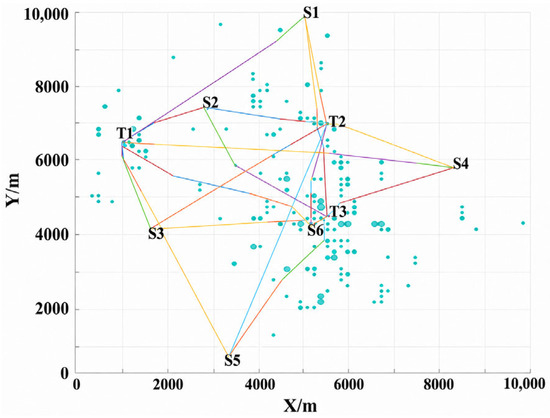
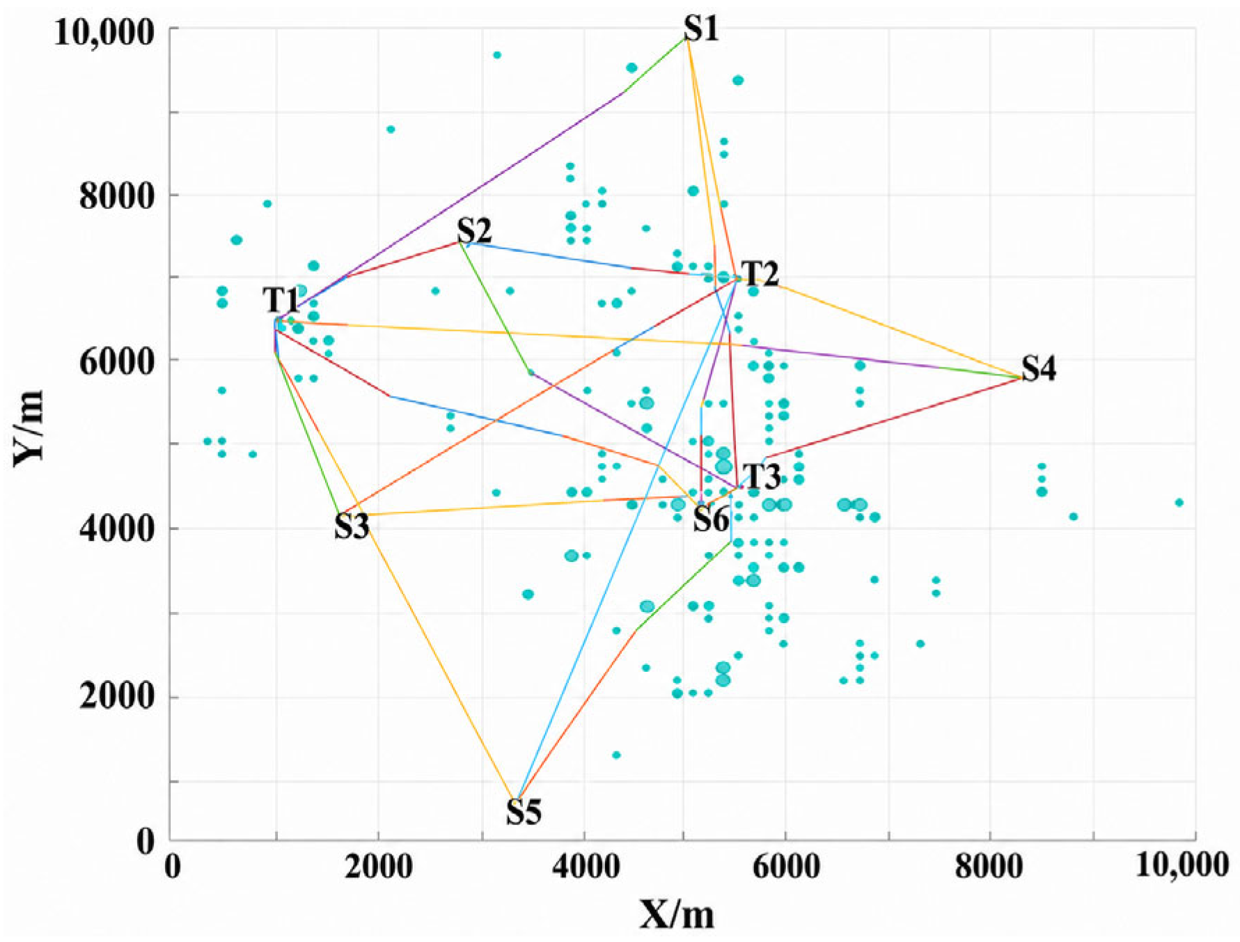
For the three fire locations T1, T2, and T3, the optimal flight paths from the six fire stations are calculated under no-wind, southeasterly wind, and southwesterly wind conditions. Under the no-wind condition, as shown in Figure 8 and Table 3, the actual flight paths after obstacle avoidance increase only slightly compared with the corresponding straight-line distances. The maximum spatial increase is 187.85 m for the S5-T3 route, and the resulting flight-time penalty is less than 10 s. This indicates that, under the same meteorological condition, the time delay caused by obstacle avoidance can be approximately neglected. In addition, the size and distribution density of obstacles along the route directly affect local path complexity. Denser obstacles lead to more frequent UAV maneuvers and finer path segmentation. However, owing to global path preplanning, the number of macroscopic path segments for each origin–destination pair is effectively controlled within five.
Figure 8.
Visualization summary of flight path solutions under the no-wind condition.
Table 3.
Obstacle-avoidance flight path lengths and straight-line distances for each origin–destination pair.
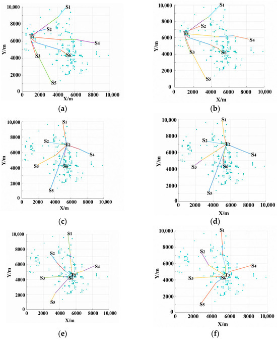
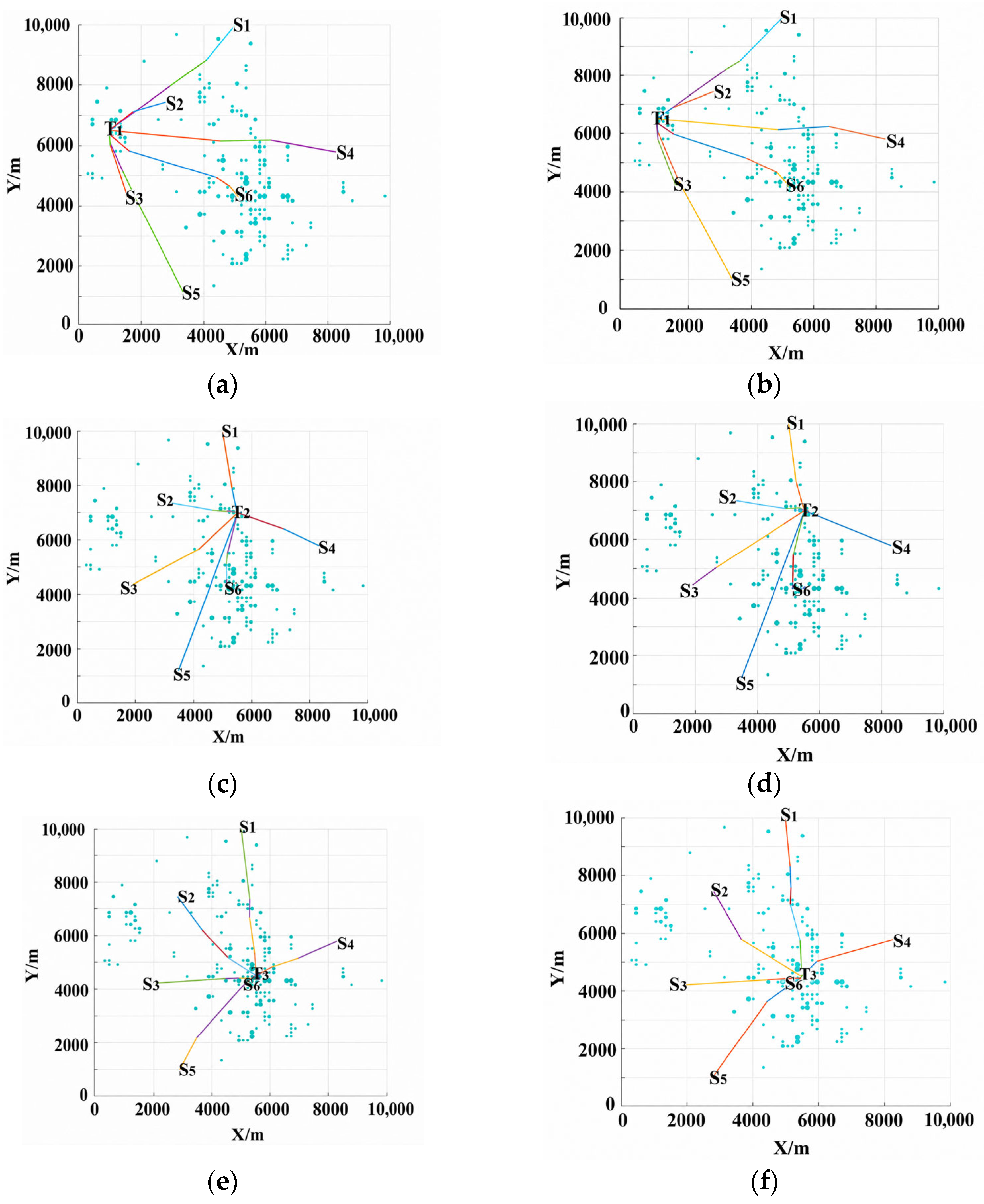
After environmental wind is introduced, the positions of the path nodes are slightly adjusted, while the overall macroscopic geometric configurations remain highly consistent (Figure 9). However, wind-field variations exert a significant non-linear effect on flight times and reorder the fleet arrival timeline, breaking the simplistic correlation between physical distance and response priority. As summarized in Table 4, under identical spatial constraints, the baseline arrival sequence under the no-wind condition is determined primarily by physical distances. Once wind vectors are superimposed, the aerodynamic vector superposition changes the actual ground speed along the prescribed flight paths, shrinking or amplifying response gaps. For instance, a southwesterly wind aligned with the S1-T1 route provides a major ground-speed gain, reducing flight time by approximately 20% (from 267.13 s to 213.85 s). These wind-induced variations directly perturb the inputs for the subsequent resource scheduling phase.
Figure 9.
Visualization results of flight path solutions under environmental wind conditions. (a) Target fire point T1 (970, 6500), southeast wind. (b) Target fire point T1 (970, 6500), southwest wind. (c) Target fire point T2 (5500, 7000), southeast wind. (d) Target fire point T2 (5500, 7000), southwest wind. (e) Target fire point T3 (5500, 4500), southeast wind. (f) Target fire point T3 (5500, 4500), southwest wind.
Table 4.
UAV flight times and mean values for each origin–destination pair under different wind conditions.
In summary, the environmental wind field does not substantially change the optimized obstacle-avoidance path geometry in the horizontal plane, but it significantly changes the temporal cost of the mission. The wind-induced differences in UAV arrival times directly affect the resource scheduling scheme for multi-UAV cooperative projectile release. Therefore, wind-field factors must be comprehensively considered in practical fire suppression mission planning to optimize the selection of departure stations and flight paths.
4.2.4. UAV Fire Suppression Response
Based on the MILP model in which UAV dispatch status and projectile allocation are decision variables, the optimal UAV scheduling scheme and the corresponding fire suppression response time are obtained. The projectile release times are subsequently determined from the UAV arrival times, the optimized projectile allocations, and the prescribed release interval. To further investigate the influence of different fire scales on mission planning strategies, the initial heat release rates are set to 140 kW and 280 kW, respectively. Scheduling optimization is then performed under no-wind and southeasterly wind conditions. Based on the simulation results in Table 5 and Table 6, the following analysis is conducted from three perspectives: environmental wind-field disturbance, projectile release timing distribution, and dynamic fire scale.
Table 5.
Solution results for .
Table 6.
Solution results for .
- Influence of environmental wind on UAV scheduling schemes
Environmental wind significantly reshapes the multi-station dispatching strategy by altering individual UAV flight times. For the 140 kW fire at T2, the optimal no-wind strategy dispatches one UAV each from stations S1, S2, S4, and S6. In this scheme, S6 and S2, as well as S1 and S4, form two temporally concentrated cooperative suppression pairs. These coordinated releases substantially reduce the fire intensity and enable the fire to be fully suppressed within a total mission duration of 152.33 s. Specifically, the two pairs achieve fire intensity reductions of 64.5% and 61.8%, respectively, with inter-release intervals of less than 1 s. The balanced allocation of one projectile per station is therefore sufficient to suppress the fire. Under the southeasterly wind condition, however, dispatching UAV S1 becomes less favorable in the optimal schedule. Consequently, UAVs from stations S2, S4, and S6 are dispatched, releasing 1, 2, and 2 extinguishing projectiles, respectively. In this case, only S6 and S4 form a cooperative pair with a relatively large release interval of approximately 4 s, whereas the release from S2 is significantly delayed. As a result, the fire continues to develop during the operational gap, and the total fire suppression mission duration increases to 173.23 s.
This wind-induced operational shift highlights the specific coupling boundary between external wind velocities and non-linear fire growth. Since high-rise building fires during their initial phases are mostly characterized as compartment fires where the ignition source remains enclosed within architectural barriers, ambient external wind vectors exert negligible direct fluid or thermal influence on the indoor combustion process. Instead, the interplay between wind conditions and fire intensity is implicitly coupled on an operational timeline; wind fields perturb the ground speed and arrival sequence of the fleet, causing cascading delays that are non-linearly amplified by the t2 fire expansion model.
- 2.
- Influence of projectile release timing distribution on fire suppression efficiency
In UAV-based fire suppression missions, operational gaps inevitably occur during the suppression process because a single UAV is constrained by the minimum time interval c between consecutive projectile releases. Taking fire locations T1 and T2 under the no-wind condition with Q = 140 kW as examples, their multi-UAV scheduling schemes and projectile release timing distributions differ substantially. As shown in Table 5, the fire at T1 is suppressed by UAVs from stations S2 and S3, with a total of five extinguishing projectiles released. By contrast, the fire at T2 is handled by UAVs from stations S1, S2, S4, and S6, with each UAV releasing one extinguishing projectile. Although the first three projectiles at T1 are released more than 20 s earlier than those at T2, the release timing at T1 is relatively dispersed, allowing the fire to continue developing during prolonged operational gaps. Consequently, more extinguishing projectiles are required to fully suppress the fire, and the total suppression time at T1 becomes longer than that at T2. In contrast, projectile releases at T2 are highly concentrated. The intervals between the first and second projectiles and between the third and fourth projectiles are both less than 1 s, forming a strong cooperative suppression effect. After the second projectile is released, the fire intensity decreases sharply by approximately 66%. The subsequent nearly simultaneous releases eliminate the remaining 83.41 kW of residual fire intensity. These results indicate that the temporal concentration of projectile release is a key factor affecting multi-UAV cooperative fire suppression efficiency. By compressing release intervals through multi-station cooperative scheduling, fire development can be effectively suppressed, thereby substantially reducing the total fire suppression mission duration.
- 3.
- Influence of fire scale on fire suppression efficiency
A comparison between the fire scenarios with and shows that the UAV scheduling strategy adapts dynamically as the fire scale increases. Taking fire location T1 under the no-wind condition as an example, when the initial fire scale doubles, the residual fire intensity after each projectile release increases. However, the total number of required extinguishing projectiles, dispatched stations, payload allocation, and final suppression time remain unchanged. This indicates that the existing scheduling scheme has a certain margin of suppression capacity. When the increase in fire scale remains within this capacity margin, the system exhibits strong robustness and can effectively suppress the enlarged fire without additional firefighting resources.
However, once the fire scale exceeds the suppression capacity margin of the existing scheduling scheme, the mission plan must be extended along the time dimension by adding fire suppression resources. Taking fire location T2 under the no-wind condition as an example, the increase in fire scale requires one additional extinguishing projectile, which is provided by station S6. As a result, the final suppression time increases from 152.33 s to 172.24 s, corresponding to an increase of approximately 13%. For fire location T3 under the no-wind condition, the increase in fire scale requires two additional extinguishing projectiles, and the dispatching scheme expands from a two-station configuration involving S4 and S6 to a three-station cooperative configuration involving S3, S4, and S6. Consequently, the total mission duration increases substantially from 154.58 s to 197.49 s, corresponding to an increase of approximately 28%. This occurs because the expansion of fire scale directly increases the demand for extinguishing projectiles. Notably, this 28% variation represents a relative logistical and scheduling efficiency gain within the mission timeline under the simplified step-change baseline, rather than an absolute thermodynamic evaluation of fire intensity reduction. Meanwhile, because each UAV is constrained by its inherent flight time, subsequent supplementary projectiles arrive later, weakening early-stage cooperative suppression and limiting the efficiency of late-stage support from remote stations.
Overall, as the fire scale increases, cross-regional deployment of firefighting resources becomes unavoidable. However, owing to the spatial constraints of the existing fire station layout, long-distance UAV flights reduce the temporal concentration of cooperative projectile releases, leading to a significant decline in support efficiency for large-scale fires. This phenomenon reveals the spatial limitations of the existing station layout in responding to extreme high-rise fire scenarios.
5. Fire Station Layout Planning
5.1. Fire Station Layout Optimization Model
Based on the simulation results presented above and the spatial distribution characteristics of fire stations and high-rise buildings in the study area, the existing fire stations are relatively dispersed, whereas high-rise buildings are mainly concentrated in the central area near station S5. When a fire occurs in such a high-density region, the long flight distances and spatiotemporal delays associated with remote stations significantly constrain the response efficiency of multi-UAV cooperative fire suppression. Therefore, it is necessary to optimize the existing fire station layout by adding forward-deployed fire stations in high-rise building clusters, thereby improving the emergency response capability of UAV swarms.
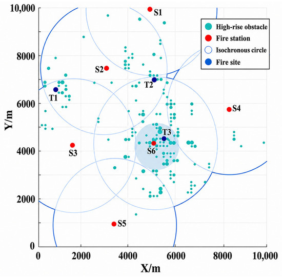
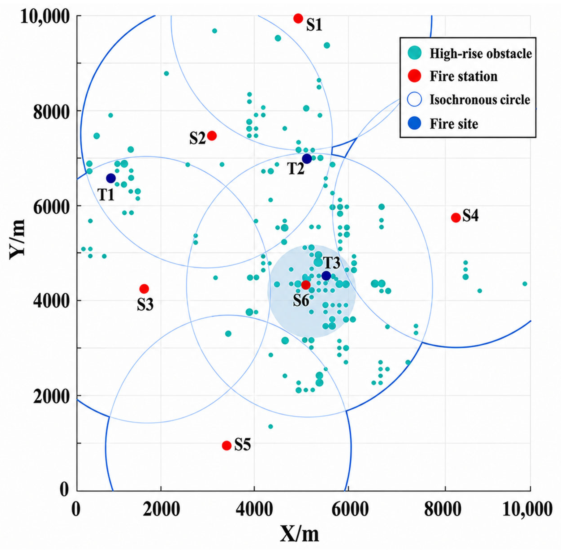
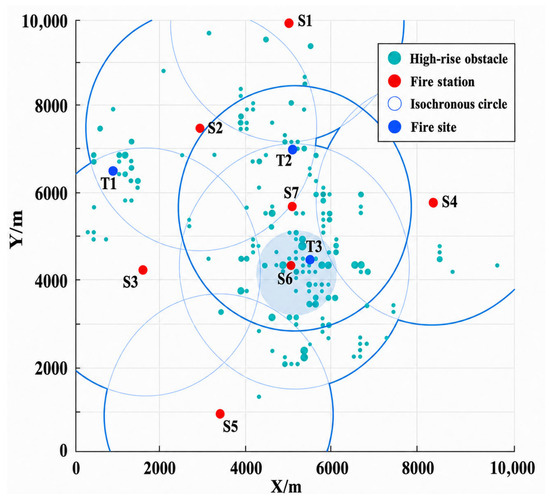
To quantitatively evaluate the spatial coverage capability of fire stations, this study introduces the concept of an isochrone-based firefighting coverage circle. As a theoretical foundation, spatial coverage analysis has been widely used in emergency response planning to evaluate service accessibility, response redundancy, and spatial allocation efficiency [40]. It is assumed that, during emergency response, UAVs fly along straight-line paths, and the local flight-distance increase caused by minor obstacle avoidance is neglected. Each fire station is used as the center to construct an isochrone-based firefighting coverage circle, as shown in Figure 10. To determine the response time threshold, this study refers to the 240 s travel time objective specified in NFPA 1710 for the first arriving ground engine company [41]. Because aerial units fly directly from stations to target scenes and remain completely unaffected by ground traffic congestion, intersection delays, or road network detours, a more stringent 120 s threshold is adopted as a planning level baseline for rapid initial intervention. This parameter functions as an adjustable planning baseline rather than a rigid regulatory standard, which can be dynamically calibrated in practical applications based on platform performance, building density, and local emergency requirements. Under this time constraint, and given a cruising speed of 20 m per s under the no wind condition, the effective coverage radius of the isochrone-based firefighting coverage circle is determined to be 2400 m.
Figure 10.
Schematic diagram of the isochrone-based firefighting coverage circle.
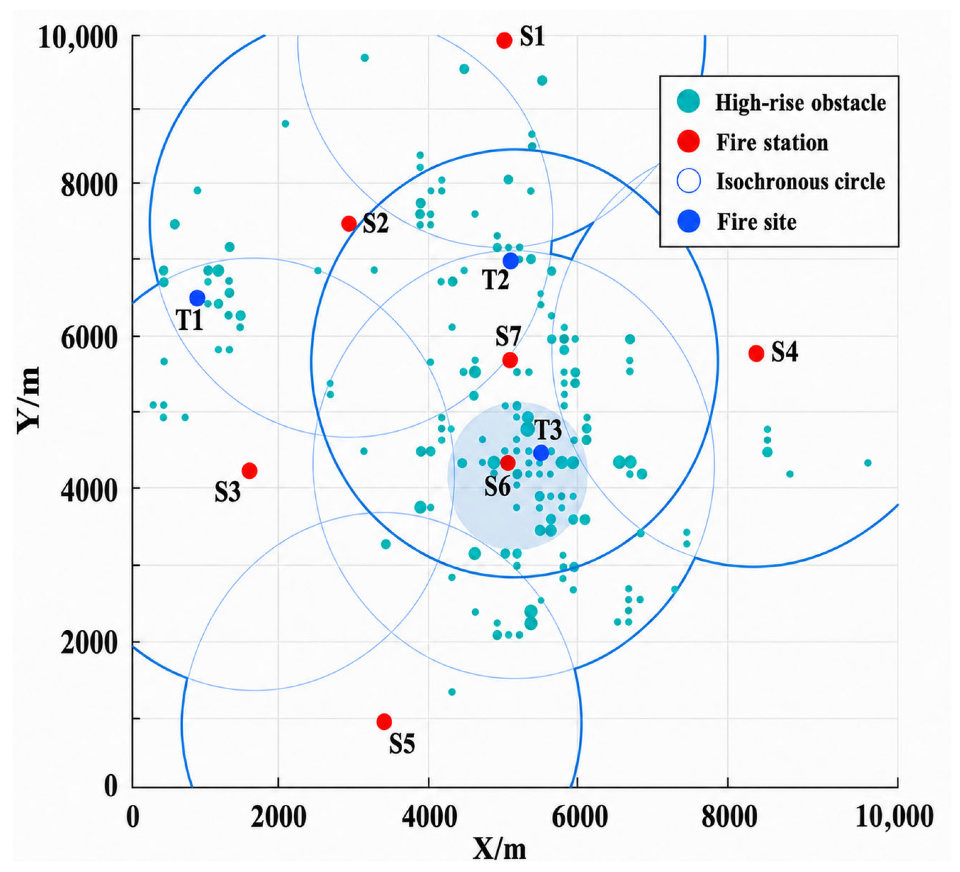
The number of spatial overlaps among the isochrone-based firefighting coverage circles generated by different fire stations intuitively reflects the number of UAVs that can be jointly dispatched within a given response-time window. A greater number of overlapping layers indicates stronger redundancy in regional fire suppression support capacity. As shown in Figure 10, a circular region centered at (5200, 4200) with a radius of 900 m is defined as the high-density core area of high-rise buildings. Although this critical area is located close to station S5, its coverage by the existing isochrone-based firefighting coverage circles is insufficient, with only single-layer coverage provided by S5. Once the fire scale increases, such single-layer coverage may lead to insufficient dispatchable UAV resources and a sharp increase in fire suppression time. Therefore, this study proposes adding a new fire station, denoted as S7, in this region. The isochrone-based firefighting coverage circle of S7 is expected to fully enclose the high-rise buildings within the core area, thereby forming a dual-layer or multi-layer cooperative coverage network with existing stations and effectively alleviating local fire suppression pressure.
To ensure that the newly added station not only improves the coverage level of the high-density core area but also provides rapid support for the surrounding representative fire locations T1, T2, and T3, a location optimization objective is established by minimizing the weighted sum of straight-line distances from the new station to these fire locations:
where denotes the weighted sum of Euclidean distances from the newly added fire station S7(, ) to the three representative fire locations. Here, k = 1, 2, 3 correspond to fire locations T1, T2, and T3, respectively; (, ) denotes the planar coordinate of the k-th fire location; and , , and denote the corresponding spatial support weighting coefficients.
To ensure that the isochrone-based firefighting coverage circle of S7 fully encloses the high-density core area, the spatial topological relationship between the two circles must satisfy containment or internal tangency. Let (x0,y0) denote the center of the high-density core area, denote the radius of the core area, and denote the radius of the isochrone-based firefighting coverage circle of S7. Given , the geometric constraint can be expressed as,
where , and
5.2. Simulation Results and Analysis of the New Fire Station S7
To simultaneously satisfy the coverage requirement of the high-density core area and the response-time requirement for surrounding representative fire locations, four sets of spatial support weighting combinations are defined, as shown in Table 7. These specific λ configurations are selected to represent critical trade-off regions between maximizing localized coverage potential and prioritizing peripheral accessibility, thereby highlighting the spatial transition points where the service influence of the added station shifts from concentrated high-rise clusters toward peripheral zones. To preserve computational tractability and prevent highly non-convex search spaces inherent to unified formulations, a decoupled planning scheme is purposefully implemented in this two-stage framework. Under this approach, the first-stage siting model utilizes spatial building coverage as a fundamental anchor to guarantee baseline service capability. Subsequently, the second-stage UAV scheduling model dynamically refines actual flight times and resource distribution under wind fields and spatial obstacles. This sequential design effectively satisfies granular, time-critical requirements by routing UAVs dynamically, rather than overloading a single planning solver.
Table 7.
Coordinates of S7 and the number of covered high-rise buildings under different weighting combinations.
A heuristic optimization procedure is then performed in a Python-based computational framework. Taking the center of the core area, (5200, 4200), as the initial iteration point, the optimal coordinates of the new station and the corresponding number of high-rise buildings covered by its isochrone-based firefighting coverage circle are obtained. The results show that, under the fourth weighting configuration, where λT1 = λT2 = 1/4 and λT3 = 1/2, the isochrone-based firefighting coverage circle centered at (5036, 5691) covers the largest number of high-rise buildings. Therefore, this location is selected as the final site of the newly added fire station S7, as shown in Figure 11.
Figure 11.
Schematic layout of the newly added fire station S7.
The simulation results in Table 8 show that the newly added station significantly improves the overall regional fire suppression performance. First, S7 effectively compensates for the insufficient coverage of the high-density core area and demonstrates a strong spatial accessibility advantage. Under the no-wind condition, the single-UAV flight times from S7 to fire locations T1, T2, and T3 are reduced to approximately 237 s, 69 s, and 64 s, respectively. In the 140 kW fire scenario, the total fire suppression mission durations at T2 and T3 are reduced by 9% and 59%, respectively, compared with the original scheme. In the 280 kW fire scenario, the corresponding reductions reach 19% and approximately 50%. Similar to the previous scheduling analysis, these metrics signify operational and resource-allocation timeline efficiencies derived from multi-station coordination rather than physical suppression performance. These results indicate that the newly added station has significant advantages in spatiotemporal accessibility and rapid response. Second, the introduction of S7 changes the network structure of multi-UAV cooperative scheduling. Taking the 280 kW fire at T2 as an example, the original scheme requires cross-regional coordination among stations S2, S4, and S6 to complete five projectile release tasks. After S7 is introduced, the scheduling system is reconfigured into a cooperative operation involving S2, S6, and S7. Owing to its spatial proximity, S7 directly undertakes three major projectile release tasks. This scheduling pattern not only reduces the total fire suppression mission duration by 19%, but also decreases the dependence on long-distance dispatching from remote stations, thereby enabling a more centralized allocation of emergency response resources. Furthermore, S7 exhibits strong disturbance resistance and scheduling flexibility when the fire scale changes. Taking fire location T3 as an example, when the fire scale increases from 140 kW to 280 kW, the original scheduling network must expand from a two-station configuration to a three-station cooperative configuration, resulting in a 43 s increase in fire suppression duration. In contrast, with the support of S7, stations S6 and S7 are sufficient to handle the doubled fire scale, and the increase in total mission duration is controlled within 35 s. This indicates that the introduction of S7 improves resource redundancy when the system responds to high-load fire scenarios.
Table 8.
Solution results after introducing the newly added station S7 under the no-wind condition.
In summary, the newly added station S7 effectively addresses the insufficient coverage of high-rise building clusters in the original layout and provides efficient response capability for regions around T2 and T3. In both small- and large-scale fire scenarios, it significantly reduces the fire suppression mission duration and improves the overall emergency response capability for high-rise fire suppression in the region. These results validate the effectiveness of the fire station layout optimization method based on the isochrone-based firefighting coverage circle.
6. Conclusions
This study develops a two-stage mission planning model for multi-station UAV-based firefighting systems to address the low efficiency of emergency response in urban high-rise buildings. By integrating UAV path planning, resource scheduling, and an isochrone-based firefighting coverage circle, the proposed method provides a comprehensive quantitative planning strategies for cooperative fire suppression, bridging the gap between static station layout and dynamic mission execution. The main findings are summarized as follows:
- (1)
- The additional flight time caused by geometric obstacle avoidance is relatively small and can be approximately neglected. However, dense large-scale obstacles significantly increase UAV maneuvering frequency and operational risk. While optimized paths remain geometrically similar under different wind-field conditions, wind-induced flight time variations significantly alter flight times and UAV arrival sequences, which directly affect the subsequent selection of dispatched stations.
- (2)
- An increase in fire scale raises the demand for extinguishing projectiles and UAV dispatches. The spatial distribution of fire stations determines the flight time of each UAV, which in turn dictates the temporal distribution of projectile release timing. Long release intervals and low coordination efficiency under unfavorable conditions can increase the total fire suppression mission duration by more than 28%.
- (3)
- The isochrone-based firefighting coverage circle effectively maximizes the coverage of high-rise buildings and addresses prolonged suppression times in local regions. After optimally located fire stations are added, the total fire suppression mission duration is reduced by approximately 50% or more under both small- and large-scale fire scenarios, substantially improving overall emergency response capability.
Deploying UAVs for high-rise fire suppression effectively circumvents response delays caused by ground traffic constraints and reduces the reliance on ground-based emergency resources. To advance this framework, future work will first extend the current two-dimensional simplification to three-dimensional path planning while explicitly incorporating hovering energy consumption and dynamic payload variations. Additionally, comprehensive sensitivity analyses across large-scale randomized scenarios will be conducted to evaluate heterogeneous UAV parameters and dynamic wind velocities under unpredictable disaster conditions. Ultimately, these steps will culminate in a comprehensive Pareto-front analysis using multi-objective optimization (MOO) algorithms to systematically map the optimal trade-off curves under competing operational priorities.
Author Contributions
Conceptualization, J.Z.; methodology, J.Z., J.Y. and P.Z.; software, J.Z., Z.S. and Q.S.; writing—original draft preparation, J.Z. and J.Y.; writing—review and editing, P.Z. All authors have read and agreed to the published version of the manuscript.
Funding
This research is financially supported by the Major Science and Technology Special Project of Yunnan Province (Grant No. 202602AD080014), Sichuan Science and Technology Program (2026YFHZ0195), and Civil Aviation Flight University of China, the Program of Sichuan Flight Engineering Technology Research Center (No. GY2025-05B). This research is partially funded by Basic Research Program of Jiangsu (BK20251405), the Fundamental Research Funds for the Central Universities, NO. NJ2025046, and Jiangsu Funding Program for Excellent Postdoctoral Talent.
Data Availability Statement
The original contributions presented in this study are included in the article. Further inquiries can be directed to the corresponding author.
Acknowledgments
The authors acknowledge with thanks the support for this work by the College of Civil Aviation at Nanjing University of Aeronautics and Astronautics.
Conflicts of Interest
The authors declare no conflicts of interest.
Abbreviations
The following abbreviations are sequentially used in this paper:
| UAV | Unmanned Aerial Vehicle |
| PSO | Particle Swarm Optimization |
| APSO | Adaptive Particle Swarm Optimization |
| OBL | Opposition-Based Learning |
| MILP | Mixed-Integer Linear Programming |
References
- Perez-Saura, D.; Fernandez-Cortizas, M.; Perez-Segui, R.; Arias-Perez, P.; Campoy, P. Urban firefighting drones: Precise throwing from UAV. J. Intell. Robot. Syst. 2023, 108, 66. [Google Scholar] [CrossRef] [Scilit]
- Yang, J.; Liu, J.; Liu, J. A hybrid evolution Jaya algorithm for meteorological drone trajectory planning. Appl. Math. Model. 2025, 137, 115655. [Google Scholar] [CrossRef] [Scilit]
- Wang, K.; Yuan, Y.; Chen, M.; Lou, Z.; Zhu, Z.; Li, R. A study of fire drone extinguishing system in high-rise buildings. Fire 2022, 5, 75. [Google Scholar] [CrossRef] [Scilit]
- Dieteren, S.H.P. Application of Drone Technology for Firefighting. Bachelor’s Thesis, University of Twente, Enschede, The Netherlands, 2021. [Google Scholar]
- Liu, Z.; Zhang, J.; Zhu, Y.; Cai, K. Hierarchical four-dimensional trajectories planning method for manned and unmanned aircraft integrated airspace. J. Guid. Control Dyn. 2022, 45, 1017–1032. [Google Scholar] [CrossRef] [Scilit]
- Tao, F.; Chen, Z.; Wang, Z.; Zhu, L.; Wang, J. Multistrategy improved particle swarm optimization algorithm for path planning of UAV in 3-D low altitude urban environment. IEEE Internet Things J. 2025, 12, 40470–40483. [Google Scholar] [CrossRef] [Scilit]
- Saeed, R.A.; Omri, M.; Abdel-Khalek, S.; Ali, E.S.; Alotaibi, M.F. Optimal path planning for drones based on swarm intelligence algorithm. Neural Comput. Appl. 2022, 34, 10133–10155. [Google Scholar] [CrossRef] [Scilit]
- Rienecker, H.; Hildebrand, V.; Pfifer, H. Energy optimal flight path planning for unmanned aerial vehicles in urban envi-ronments based on a novel energy-distance map. In Proceedings of the AIAA SCITECH 2024 Forum, Orlando, FL, USA, 8–12 January 2024. AIAA Paper 2024-2394. [Google Scholar]
- Souto, A.; Alfaia, R.; Cardoso, E.; Araújo, J.; Francês, C. UAV path planning optimization strategy: Considerations of urban morphology, microclimate, and energy efficiency using Q-learning algorithm. Drones 2023, 7, 123. [Google Scholar] [CrossRef] [Scilit]
- Schwarzrock, J.; Zacarias, I.; Bazzan, A.L.; Fernandes, R.Q.d.A.; Moreira, L.H.; de Freitas, E.P. Solving task allocation problem in multi unmanned aerial vehicles systems using swarm intelligence. Eng. Appl. Artif. Intell. 2018, 72, 10–20. [Google Scholar] [CrossRef] [Scilit]
- Peng, Q.; Wu, H.; Li, N.; Wang, F. A Dynamic task allocation method for unmanned aerial vehicle swarm based on wolf pack labor division model. IEEE Trans. Emerg. Top. Comput. Intell. 2024, 8, 4075–4089. [Google Scholar] [CrossRef] [Scilit]
- Alotaibi, E.T.; Alqefari, S.S.; Koubaa, A. LSAR: Multi-UAV collaboration for search and rescue missions. IEEE Access 2019, 7, 55817–55832. [Google Scholar] [CrossRef] [Scilit]
- Shen, Y.; Wang, X.; Wang, H.; Guo, Y.; Chen, X.; Han, J. A dynamic task assignment model for aviation emergency rescue based on multi-agent reinforcement learning. J. Saf. Sci. Resil. 2023, 4, 284–293. [Google Scholar] [CrossRef] [Scilit]
- Tang, J.; Chen, X.; Zhu, X.; Zhu, F. Dynamic reallocation model of multiple unmanned aerial vehicle tasks in emergent adjustment scenarios. IEEE Trans. Aerosp. Electron. Syst. 2022, 59, 1139–1155. [Google Scholar] [CrossRef] [Scilit]
- Li, C.; Li, G.; Liu, Y.; Zheng, Q.; Yang, G.; Liu, K.; Diao, X. Cooperative task allocation for unmanned aerial vehicle swarm using multi-objective multi-population self-adaptive ant lion optimizer. Drones 2025, 9, 733. [Google Scholar] [CrossRef] [Scilit]
- Han, D.; Jiang, H.; Wang, L.; Zhu, X.; Chen, Y.; Yu, Q. Collaborative task allocation and optimization solution for unmanned aerial vehicles in search and rescue. Drones 2024, 8, 138. [Google Scholar] [CrossRef] [Scilit]
- Yan, F.; Chu, J.; Hu, J.; Zhu, X. Cooperative task allocation with simultaneous arrival and resource constraint for multi-UAV using a genetic algorithm. Expert Syst. Appl. 2024, 245, 123023. [Google Scholar] [CrossRef] [Scilit]
- Papaioannou, S.; Kolios, P.; Theocharides, T.; Panayiotou, C.G.; Polycarpou, M.M. Towards automated 3D search planning for emergency response missions. J. Intell. Robot. Syst. 2021, 103, 2. [Google Scholar] [CrossRef] [Scilit]
- Melhim, L.K.B.; Jemmali, M.; Boulila, W.; Alazab, M.; Rani, S.; Campbell, H.; Amdouni, H. Leveraging drone-assisted surveillance for effective forest conservation: A case study in Australia’s Daintree Rainforest. IEEE Internet Things J. 2024, 11, 31167–31179. [Google Scholar] [CrossRef] [Scilit]
- Xiong, T.; Liu, F.; Liu, H.; Ge, J.; Li, H.; Ding, K.; Li, Q. Multi-drone optimal mission assignment and 3D path planning for disaster rescue. Drones 2023, 7, 394. [Google Scholar] [CrossRef] [Scilit]
- Aggarwal, R.; Soderlund, A.; Kumar, M.; Grymin, D.J. Risk-Aware Path Planning for Unmanned Aerial Systems in a Spreading Wildfire. J. Guid. Control. Dyn. 2022, 45, 1692–1708. [Google Scholar] [CrossRef] [Scilit]
- Xu, Y.; Li, J.; Zhang, F. A UAV-Based Forest Fire Patrol Path Planning Strategy. Forests 2022, 13, 1952. [Google Scholar] [CrossRef] [Scilit]
- Demir, K.; Tumen, V.; Kosunalp, S.; Iliev, T. A Deep Reinforcement Learning Algorithm for Trajectory Planning of Swarm UAV Fulfilling Wildfire Reconnaissance. Electronics 2024, 13, 2568. [Google Scholar] [CrossRef] [Scilit]
- Otto, A.; Agatz, N.; Campbell, J.; Golden, B.; Pesch, E. Optimization approaches for civil applications of unmanned aerial vehicles (UAVs) or aerial drones: A survey. Networks 2018, 72, 411–458. [Google Scholar] [CrossRef] [Scilit]
- Murray, C.C.; Raj, R. The multiple flying sidekicks traveling salesman problem: Parcel delivery with multiple drones. Transp. Res. Part C Emerg. Technol. 2020, 110, 368–398. [Google Scholar] [CrossRef] [Scilit]
- Dell’Amico, M.; Montemanni, R.; Novellani, S. Algorithms based on branch and bound for the flying sidekick traveling salesman problem. Omega 2021, 104, 102493. [Google Scholar] [CrossRef] [Scilit]
- Delamer, J.-A.; Watanabe, Y.; Chanel, C.P.C. Safe path planning for UAV urban operation under GNSS signal occlusion risk. Robot. Auton. Syst. 2021, 142, 103800. [Google Scholar] [CrossRef] [Scilit]
- Gu, R.; Zhao, Y.; Ren, X. Integrating wind field analysis in UAV path planning: Enhancing safety and energy efficiency for urban logistics. Chin. J. Aeronaut. 2026, 39, 103605. [Google Scholar] [CrossRef] [Scilit]
- Shi, Y.; Eberhart, R. A modified particle swarm optimizer. In Proceedings of the 1998 IEEE International Conference on Evolutionary Computation Proceedings. IEEE World Congress on Computational Intelligence (Cat. No.98TH8360), Anchorage, AK, USA, 4–9 May 1998; Volume 890, pp. 69–73. [Google Scholar]
- Ma, Y.Y.; Jin, H.B.; Li, H.; Zhang, H.; Li, J. Adaptive opposition-based particle swarm optimization algorithm and application research. In Proceedings of the 2019 IEEE 4th International Conference on Signal and Image Processing (ICSIP); IEEE: New York, NY, USA, 2019; pp. 518–523. [Google Scholar]
- Qian, F.; Mahmoudi, M.R.; Parvïn, H.; Pho, K.-H.; Tuan, B.A. An adaptive particle swarm optimization algorithm for unconstrained optimization. Complexity 2020, 2020, 2010545. [Google Scholar] [CrossRef] [Scilit]
- Tian, D.; Sun, J.; Li, F.; Fan, Y.; Gou, X.; Peng, S.; Shi, Z. Hybrid Particle Swarm Optimization with Chaotic Opposition-Based Initialization and Adaptive Learning Strategy. Algorithms 2026, 19, 344. [Google Scholar] [CrossRef] [Scilit]
- Tizhoosh, H.R. Opposition-based learning: A new scheme for machine intelligence. In Proceedings of the International Conference on Computational Intelligence for Modelling, Control and Automation and International Conference on Intelligent Agents, Web Technologies and Internet Commerce (CIMCA-IAWTIC 2005), Vienna, Austria, 28 November 2005; Volume 1, pp. 695–701. [Google Scholar]
- Ratnaweera, A.; Halgamuge, S.C.; Watson, H.K. Self-organizing hierarchical particle swarm optimizer with time-varying acceleration coefficients. IEEE Trans. Evol. Comput. 2004, 8, 240–255. [Google Scholar] [CrossRef] [Scilit]
- Mitchell, S.; O’Sullivan, M.; Dunning, I. PuLP: A Linear Programming Toolkit for Python; Department of Engineering Science, University of Auckland: Auckland, New Zealand, 2011. [Google Scholar]
- Acecore Technologies. Noa 6 Specification Sheet; AC-NO-SPECS, Version 4.4; Acecore Technologies: Uden, The Netherlands, 2025; Available online: https://acecoretechnologies.com/wp-content/uploads/2025/10/AC-NO-H6-SPECS.pdf (accessed on 1 October 2025).
- Zhou, T.; Liu, Y.; Wu, W.; Zhou, T. Experimental study and application of unmanned aerial vehicle releasing fire-extinguishing bomb on transmission line wildfires. Fire 2024, 7, 456. [Google Scholar] [CrossRef] [Scilit]
- Peacock, R.D.; Jones, W.W.; Reneke, P.A. CFAST-Consolidated Model of Fire Growth and Smoke Transport (Version 6): Software Development and Model Evaluation Guide; NIST Special Publication 1086r1; National Institute of Standards and Technology: Gaithersburg, MD, USA, 2013.
- Thanellas, G.A.; Moulianitis, V.C.; Aspragathos, N.A. A spatially wind aware quadcopter (UAV) path planning approach. IFAC-PapersOnLine 2019, 52, 283–288. [Google Scholar] [CrossRef] [Scilit]
- Li, X.; Zhao, Z.; Zhu, X.; Wyatt, T. Covering models and optimization techniques for emergency response facility location and planning: A review. Math. Methods Oper. Res. 2011, 74, 281–310. [Google Scholar] [CrossRef] [Scilit]
- NFPA 1710; Standard for the Organization and Deployment of Fire Suppression Operations, Emergency Medical Operations, and Special Operations to the Public by Career Fire Departments. National Fire Protection Association: Quincy, MA, USA, 2020.

Disclaimer/Publisher’s Note: The statements, opinions and data contained in all publications are solely those of the individual author(s) and contributor(s) and not of MDPI and/or the editor(s). MDPI and/or the editor(s) disclaim responsibility for any injury to people or property resulting from any ideas, methods, instructions or products referred to in the content. |
© 2026 by the authors. Licensee MDPI, Basel, Switzerland. This article is an open access article distributed under the terms and conditions of the Creative Commons Attribution (CC BY) license.