


Abstract
The Changbai Mountain Forest Region contains one of the best-preserved mountain forest ecosystems in eastern Asia and serves as a critical ecological barrier in China. Using the Baihe Forestry Bureau as the study area, this research quantified forest surface fire behavior, and based on the historical wildfire occurrence data and the forest fire spread trends, proposed targeted strategies for fire prevention and emergency resource allocation. Forest fires in the coniferous and broad-leaved mixed near-mature forest pose the greatest threat to the region. The establishment of five supply storages in five strategic locations and the construction of new firebreak roads are essential for effective fire management in the Baihe Forestry Bureau.
1. Introduction
With the intensification of global warming and human activities, the frequency, extent, and severity of forest fires worldwide have been increasing, posing serious threats to ecosystems, human life, and property [1,2,3]. In recent years, many large-scale forest fires have resulted in significant casualties among forest firefighters [4]. Consequently, both scholars and fire management authorities have recognized the urgency of advancing forest fire management. A large amount of research has examined forest fire behavior and ecological impact, while growing attention has been given to forest fire management, particularly in the area of targeted region-specific strategies [5]. Forest fire emergency resources are key to forest fire management, supporting monitoring and early warning, forest fire suppression, emergency response, and firefighter safety [6]. Rational planning, allocation, and the optimization of these existing resources are essential to improve the efficiency of forest fire monitoring, early warning and the timeliness of forest fire suppression, thereby reducing the loss of forest resources and protecting human lives [7].
Forest firefighters face numerous hazards during forest fire suppression operations, including rugged mountain roads, obstacles within complex fire environments, and extreme heat. The reserve allocation and optimization of emergency resources can help reduce the operational complexity, danger and uncertainty associated with firefighting. Consequently, recent research has increasingly focused on enhancing emergency response capabilities. For example, forest firebreak road planning [8,9,10], spatial distribution of forest fire brigades [11,12], visibility analysis of watchtowers [13,14], fire safety assessments [15,16], decision-making for emergency resource management, etc. [17,18,19].
However, most research on emergency resources for forest fires addresses the optimization of emergency resource allocation in a representative fire scenario, with fewer investigations into long-term, landscape-level planning. Forest fire occurrence patterns serve as the benchmark for the long-term layout of emergency resources and materials storage [20] while the behavior of forest fires provides the basis for the scientific dispatch and allocation of emergency resources during fire events [21]. Therefore, integrating forest fire occurrence patterns with the existing conditions of emergency resources and optimizing the existing emergency resources is critical for strengthening fire prevention and control.
The Changbai Mountain Forest Region, located in Northeast China, is an ecologically significant area that plays a vital role in maintaining community stability, ecosystem security and the construction of the national ecological security barrier [22,23]. Although fire disturbance has been relatively low in recent decades in the Changbai Mountain Forest Region, the long-term accumulation of fuels has increased both fuel loads and continuity [24,25]. Combined with intensive human activities and the risk of transboundary fire incursions, the Changbai Mountain Region faces growing pressure in forest fire prevention and control.
This study was conducted with the Baihe Forestry Bureau, representative of the Changbai Mountain Forest Region, as a case study. Through field investigation and experimental analyses, we examined the characteristics of wildfire occurrence and fire behavior in the Baihe Forestry Bureau. In combination with the current status of emergency resources, the locations of the supply storages were evaluated, and the optimization strategies for firebreak roads in the forest area were proposed. The research findings are intended to provide a stronger theoretical basis and technical support for wildfire management in the Changbai Mountain Forest Region, while contributing to the long-term optimization of emergency resource allocation for large-scale forest fire prevention.
2. Data and Methods
2.1. Study Area
The Changbai Mountain Forest Region, one of China’s six major forest regions, is a critical ecological barrier in Northeast Asia. It is often referred to as the “Changbai Forest Sea”, the “Northeast Water Tower” and the “Species Gene Bank”. As a designated national key ecological function zone, it has an extremely important ecological value for the Northeast region and plays an irreplaceable role in maintaining the sustainable development of the region [26]. The Baihe Forestry Bureau of Jilin Province, which is situated adjacent to the Changbai Mountain National Nature Reserve and located in the heart of the Changbai Mountain, lies at the northern gateway of the Changbai Mountain, and shares a land border with North Korea. This geographic setting makes forest fire prevention particularly challenging and significant.
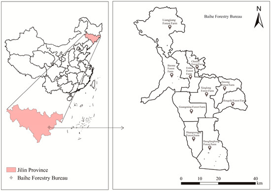
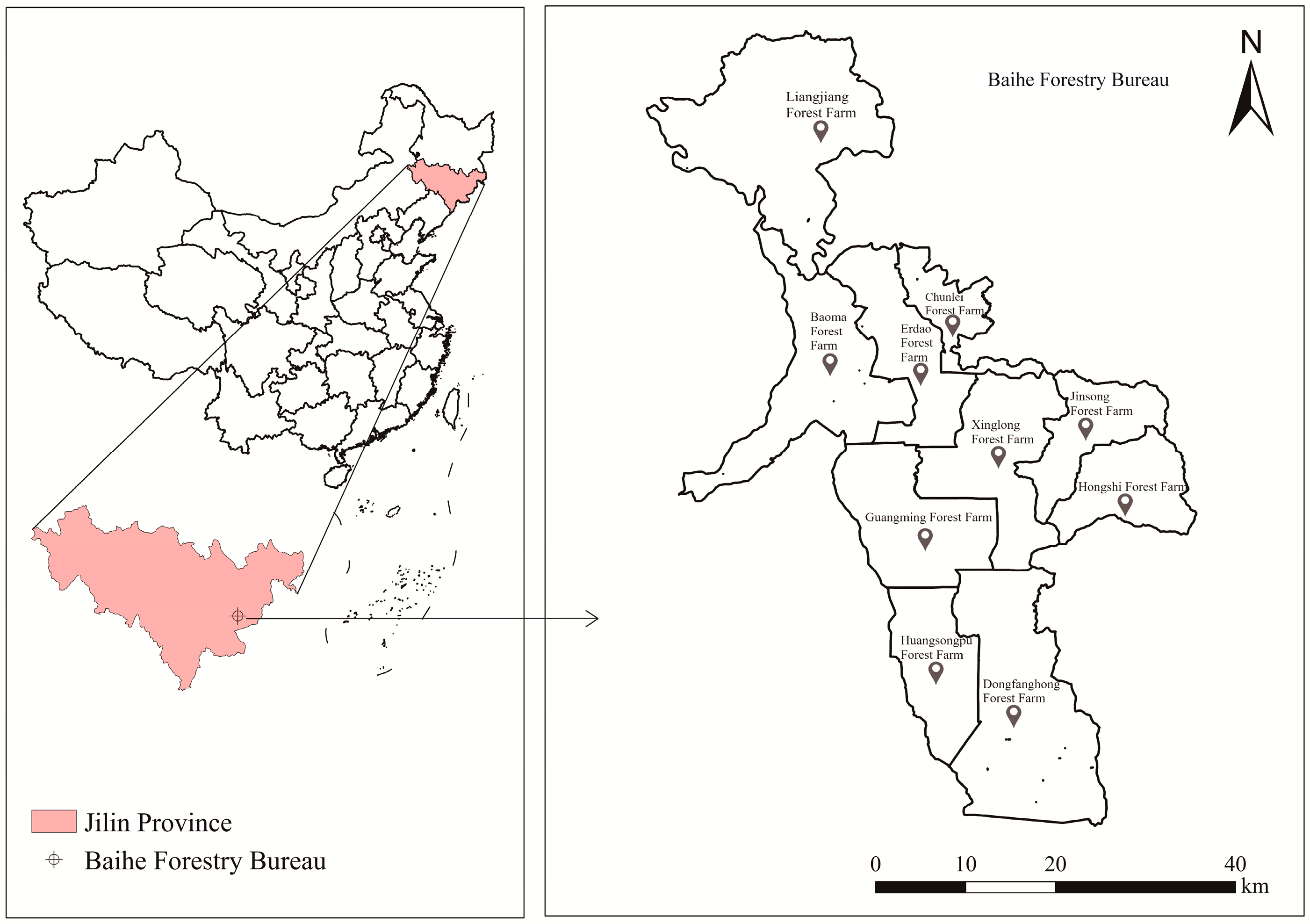
The Baihe Forestry Bureau is located in Antu County, Yanbian Korean Autonomous Prefecture, Jilin Province (127°53′–128°34′ E, 42°01′–42°48′ N) (Figure 1). It covers an area of 190,500 hm2 in a long and narrow strip extending from northwest to southeast. The Bureau manages 10 forest farms, with 182,100 hm2 of forest land and a forest coverage rate of 95.6%. The region has a temperate continental climate, diverse landforms and abundant forest resources, belonging to the Changbai Mountain flora. Dominant tree species include Larix olgensis, Picea asperata, Abies fabri, Pinus koraiensis, Fraxinus mandshurica, Juglans mandshurica, Quercus mongolica, Betula platyphylla, etc. [27].
Figure 1.
Location of the study area in China.
2.2. Acquisition of Historical Fire Data
Forest fire historical data were obtained from the Jilin Provincial Archives and the Forest and Grassland Fire Prevention and Safety Production Division of the Jilin Provincial Forestry and Grassland Bureau. The dataset includes fire location, time and geographic coordinates for all recorded forest fires in the Baihe Forestry Bureau from 1969 to 2022.
2.3. Field Investigation
Based on the forest resource inventory data of the Baihe Forestry Bureau, the main fuel types in its jurisdiction were identified as the broad-leaved mixed forests, the coniferous and broad-leaved mixed forests, the Larix olgensis forests, the broad-leaved Korean pine forests field investigations were conducted in the Baihe Forestry Bureau during the autumn fire prevention period. Sampling points were evenly distributed across all forest farms under the bureau’s jurisdiction, covering the main fuel types in the Changbai Mountain forest region. Three 30 × 20 m plots were randomly established for each fuel type. Basic plot information was investigated and recorded (Table 1).
Table 1.
Basic information of the sample plots.
2.4. Fuel Investigation
Within each 30 m × 20 m experimental plot, three 2 m × 2 m subplots were established along the diagonal. A 1 m × 1 m subplot was then nested within each 2 m × 2 m plot. Herbaceous fuels and litter were surveyed in the 1 m × 1 m subplot, while shrubs and slash were assessed in the 2 m × 2 m plot.
For each subplot, measurements included the height of different fuel layers (slash, dead grass, live grass, shrubs, and litter) and the thickness of leaves and stems of major components (dead herbaceous, live herbaceous, dead branches and fallen leaves). All fuels including herbaceous plants, shrubs, dead leaves, and woody materials were collected and weighed to determine their fresh mass. Subsamples of certain fuels were placed in envelopes, weighed, and returned to the laboratory for further analysis.
2.5. Simulation of Surface Fire Behavior
Based on the field investigation, fuel characteristics—including surface fuel load, surface-area-to-volume ratio, calorific value, and moisture content—were determined using instruments such as a forced-convection drying oven and an automatic calorimeter. Based on the characteristics of surface fuels, fire behavior was simulated using the Behave Plus 5 software, and key indicators (surface rate of spread, fireline intensity, flame length, and heat per unit area) were estimated [28].
In the present study, fireline intensity was selected as the primary indicator of fire behavior. The surface rate of spread represents the extent to which fire advances across an area, while the heat per unit area indicates the portion of the forest affected. The fireline intensity, which is derived from the fire spread rate and the heat per unit area, was therefore selected as the key indicator.
2.6. Emergency Resource Optimization
2.6.1. Emergency Resource Data
Emergency resource data were obtained from the National Forest and Grassland Fire Risk Census Platform, the Baihe Forestry Bureau. These data included information on forest fire brigades, fire prevention networks, command institutions, etc.
2.6.2. Optimal Locations Planning for Supply Storages
- (1)
- Standardization of the longitude and latitude of historical fires
The geographic coordinates of historical fire data were standardized prior to cluster analysis to eliminate dimensional influence and ensure a normalized distribution of the data [29]. The Z-score normalization method was applied, and the formula is defined as
where x denotes the original latitude or longitude of a fire point; x* denotes the standardized coordinate of the fire point; μ denotes the mean value of the latitude or longitude of all historical fire points; σ denotes the standard deviation of the latitude or longitude of all historical fire points.
- (2)
- Selection of the optimal number of clusters for historical fire sites
Before conducting clustering analysis on the standardized historical fire points, the optimal number of clusters must be determined first. The selection of cluster numbers directly affects the layout of supply storages, and a single evaluation method has limitations. Therefore, this study adopts five independent and quantitative methods simultaneously to comprehensively determine the optimal cluster number, so as to improve the reliability and stability of the results. The optimal number of clusters corresponding to each method is determined separately, and the average value of the results obtained by the five methods is then used as the final optimal number of clusters. Elbow Method [30]: This Elbow Method uses the sum of squared errors (SSE) as the evaluation metric. The SSE is calculated as follows:
where SSE denotes the total sum of squared errors from all fire points to their cluster centroids (the degree of clustering distortion); k denotes the number of clusters for fire points (i.e., the candidate number of supply storages); ci denotes the i-th cluster of fire points; p denotes the coordinate of one historical fire point in the cluster ci; mi denotes the centroid of the i-th fire cluster.
Silhouette Coefficient [31]: The Silhouette Coefficient for each point is a measure of how similar that point is to other points in the same cluster, compared to points in other clusters. The silhouette value si for the i-th point is defined as follows:
where si denotes the silhouette value of the i-th fire point; ai denotes the average distance from the i-th fire point to other fire points in the same cluster, and bi denotes the minimum average distance from the th fire point to fire points in the nearest neighboring cluster.
Calinski–Harabasz Index [32]: The Calinski–Harabasz Index is sometimes called the variance ratio criterion (VRC). The index is defined as follows:
where SSB denotes the overall between-cluster variance of fire point clusters; SSW denotes the overall within-cluster variance of fire point clusters; k denotes the number of fire point clusters (candidate number of supply storages); N denotes the total number of historical fire points.
Gap Statistic [33]: The Gap Statistic measures the gap between the clustering performance of the current number of clusters and that of a random dataset with the same distributional characteristics as the original dataset. The gap value is defined as follows:
where denotes the expectation of log(Dk).
Davies–Bouldin Index [34]: The Davies–Bouldin Index is based on a ratio of within-cluster and between-cluster distances. The Davies–Bouldin index is defined as follows:
where Di,j is the within-to-between cluster distance ratio for the i-th and j-th clusters.
- (3)
- Determination of alternative locations for the supply storages.
Based on the selected optimal cluster number, historical fire points were grouped using the K-means++ clustering algorithm and the coordinates of the cluster centers were determined for each category. The centroid of each cluster was used as an alternative location for the supply storage [35,36].
The K-means++ method follows this procedure:
① Randomly select one historical fire point coordinate as the initial cluster center from the dataset.
② Calculate the Euclidean distance from each fire point sample to its nearest cluster center. The probability of a sample being selected as the next cluster center is determined as follows:
where E(x) represents the Euclidean distance of fire point samples.
③ Determine the subsequent clustering center by employing random turntable selection according to the probability.
④ Repeat steps ①–③ until k clustering centers are confirmed. The value of k is the optimal cluster number of historical fire points.
Based on the analysis of the occurrence of surface fire behavior (i.e., the spatial distribution of historical fire points), the simulated development of surface fire behavior (i.e., the spatial distribution of simulated surface fire line intensity), and the existing emergency response forces in the region, the alternative locations for supply storages are selected or rejected.
2.6.3. Optimization of Firebreak Roads in Forest Regions
To optimize the road network layout for forest fire prevention and control, this study takes historical fire points, fire brigade stations, and supply storages as key nodes, requiring that all nodes are connected by roads and that the total length of road construction is as short as possible. Under this objective, the road network planning is essentially to find the shortest closed path traversing all key nodes, and this optimization form is highly consistent with the Traveling Salesman Problem (TSP). Therefore, this study transforms and models the forest road network planning problem as a TSP for solution.
The traveling salesman problem (TSP): Given a set of nodes and the distance between each pair of nodes, find the shortest route that visits each node exactly once and finally returns to the starting point [37,38]. Then the TSP can be expressed as follows:
where: min f denotes the shortest possible route, and d denotes the distance between key nodes (fire points, fire brigades, supply storages).
After transforming the forest road network planning problem into a TSP, considering that TSP is a typical NP-hard combinatorial optimization problem that is difficult to solve efficiently with conventional exact algorithms, this study selects Particle Swarm Optimization (PSO) for the solution. The core idea of PSO is to obtain the optimal solution through cooperation and information sharing among individuals in the population. Through individual information interaction, the population evolves from disorder to order in the space, and finally the optimal feasible solution of the problem is obtained [39].
The working principle of PSO is as follows: First, a set of particle positions are randomly initialized as initial candidate solutions. Then, individual updates are achieved by tracking the personal best solution (local extreme value) and the global best solution (global extreme value) during the iteration process. In each iteration, the particles update their velocity and position as follows:
where: Vi = (Vi1, Vi2,…, Vid) denotes the flight velocity of the i-th particle in the d-th dimension; Xi = (Xi1, Xi2,…, Xid) denotes the particle position; c1 and c2 represent the personal learning factor and the global learning factor, respectively; ω denotes the inertia weight.
3. Results
3.1. Fireline Intensity
The ranking results of surface fireline intensity under different fuel types in the Baihe Forestry Bureau are presented in Table 2. Extreme Fireline intensities (>10,000 kJ·m−1·s−1) were estimated to occur in Coniferous and Broad-leaf mixed forest (near-mature forest), Broad-leaf mixed forest (near-mature forest), Broad-leaved Korean pine forest, Broad-leaf mixed forest (mature forest), Broad-leaf mixed forest (middle-aged forest), and Coniferous and Broad-leaf mixed forest (mature forest). Moderate fireline intensities were observed in Larix olgensis forest (mature forest).
Table 2.
Fireline intensity of surface fire under different fuel types.
3.2. Optimization of Supply Storages and Forest Firebreak Roads Based on Fire Occurrence
3.2.1. Optimal Selection of the Number of Clusters of Historical Fire Points
As shown in Table 3, the optimal number of fire-point clusters varied across methods. The Elbow Method (EM) showed that the optimal number of clusters was three, as the distortion degree began to slow down and Silhouette Coefficient (SC = 0.6742) reached its maximum. The Gap statistic suggested eight clusters (Gap = 0.5167). The variance ratio criterion (Calinski–Harabasz, CH = 157.2610) was highest at 10 clusters. The classification accuracy metric (Davies–Bouldin, DB) indicated nine clusters (lowest DB = 0.5947). Averaging across the five methods, the final optimal cluster number was determined to be seven.
Table 3.
Different index values of different cluster numbers of historical fire points.
3.2.2. Optimal Location Planning for Forest Fire Supply Storages
Based on the number of selected optimal clusters, fire points were classified into seven categories using the K-means++ clustering algorithm, and the cluster center coordinates were determined for each category. Supply storages serve as centralized facilities for storing firefighting resources and supporting personnel deployment, providing essential backup resources for combating forest fires. Once a forest fire occurs, two factors can reduce firefighting efficiency: the absence of a nearby depot in severely affected areas, and excessive distance between supply storages and fire points. The Baihe Forestry Bureau currently lacks dedicated supply storage, and the clustering centers of various fire points are considered candidate sites for construction. Therefore, after determining the clustering centers of fire points using K-means++ clustering algorithm, it is also necessary to comprehensively consider the spatial distribution of forest fire risk, existing fire brigades, and command institutions to identify suitable locations for establishing supply storages.
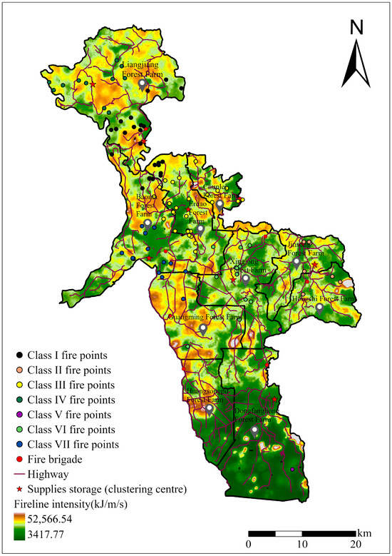
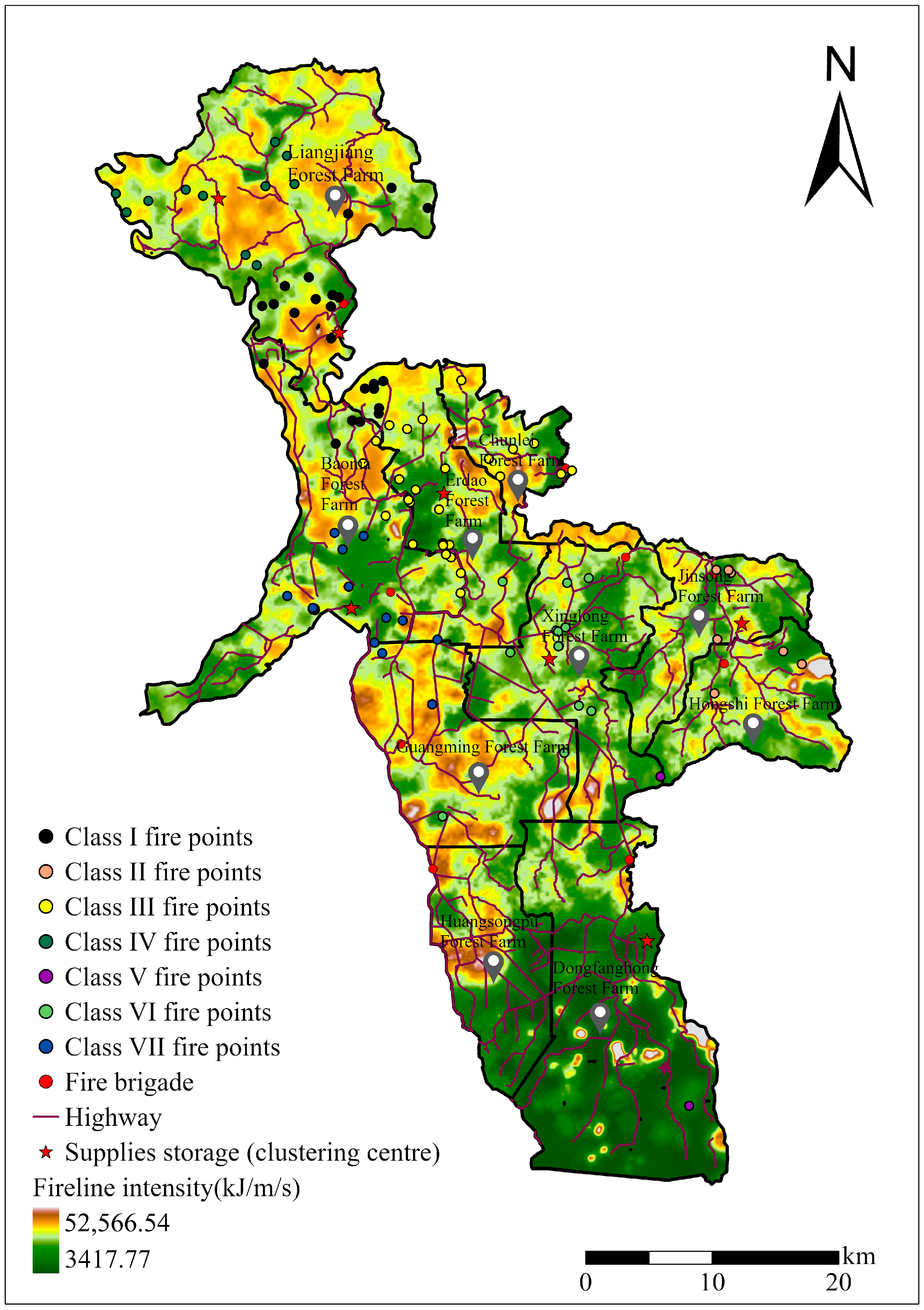
The distribution of historical fire points and surface fireline intensity is similar, both exhibiting a gradually decreasing trend from northwest to southeast (Figure 2). The historical fire points are classified into seven categories, resulting in seven cluster centers. Accordingly, seven supply storages can be established at these centers.
Figure 2.
Locations of fire points, supply storages, fire brigades, highways and clustering results of historical fire points from 1969 to 2022 at Baihe Forestry Bureau, Jilin Province, China.
The class I fire points are located in the northern part of the forestry bureau. Although a fire brigade is present, the overlap between fire point clusters and areas of high fireline intensity imposes significant demands on fire suppression capacity; therefore, a supply storage is required. The class II fire points, located in the east have two fire brigades in place and only moderate fireline intensity; thus, no further construction is needed at present. The class III fire points occur in the central part, where fire points are the most numerous and densely distributed. Despite the presence of a brigade on the eastern boundary, the block-like and interlaced fireline intensity exceeds current emergency capacity; therefore, a supply storage should be established in the Erdao Forest Farm. The class IV fire points are situated in the north, characterized by a continuous area of high fireline intensity and a lack of emergency forces; supply storage should be added in the Liangjiang Forest Farm. The class V fire points lie in the south, where fire points are sparse and the fireline intensity is lower. Although a fire brigade is deployed, the area spans multiple forest farms, warranting the establishment of a supply storage facility in the Dongfanghong Forest Farm. The class VI fire points, located in the center supply, have relatively dense fire points. Two fire brigades exist but are distant from the cluster; to ensure timely response, a supply storage facility should be established in the Xinglong Forest Farm. The class VII fire points are located in the west, where the fire points are more concentrated but show lower fireline intensity in the north and higher intensity in the south. Around the Guangming Forest Farm, where fireline intensity is slightly higher, two brigades are already deployed, adequately fulfilling the emergency resource requirements; thus, no supply storage is required. To sum up, five more supply storages are recommended for the Erdao Forest Farm, the Liangjiang Forest Farm, the Xinglong Forest Farm and the Dongfanghong Forest Farm (Table 4).
Table 4.
Geographical coordinates of recommended supply storage facilities.
3.2.3. Path Optimization
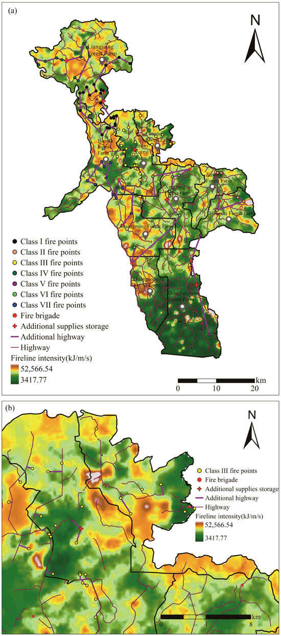
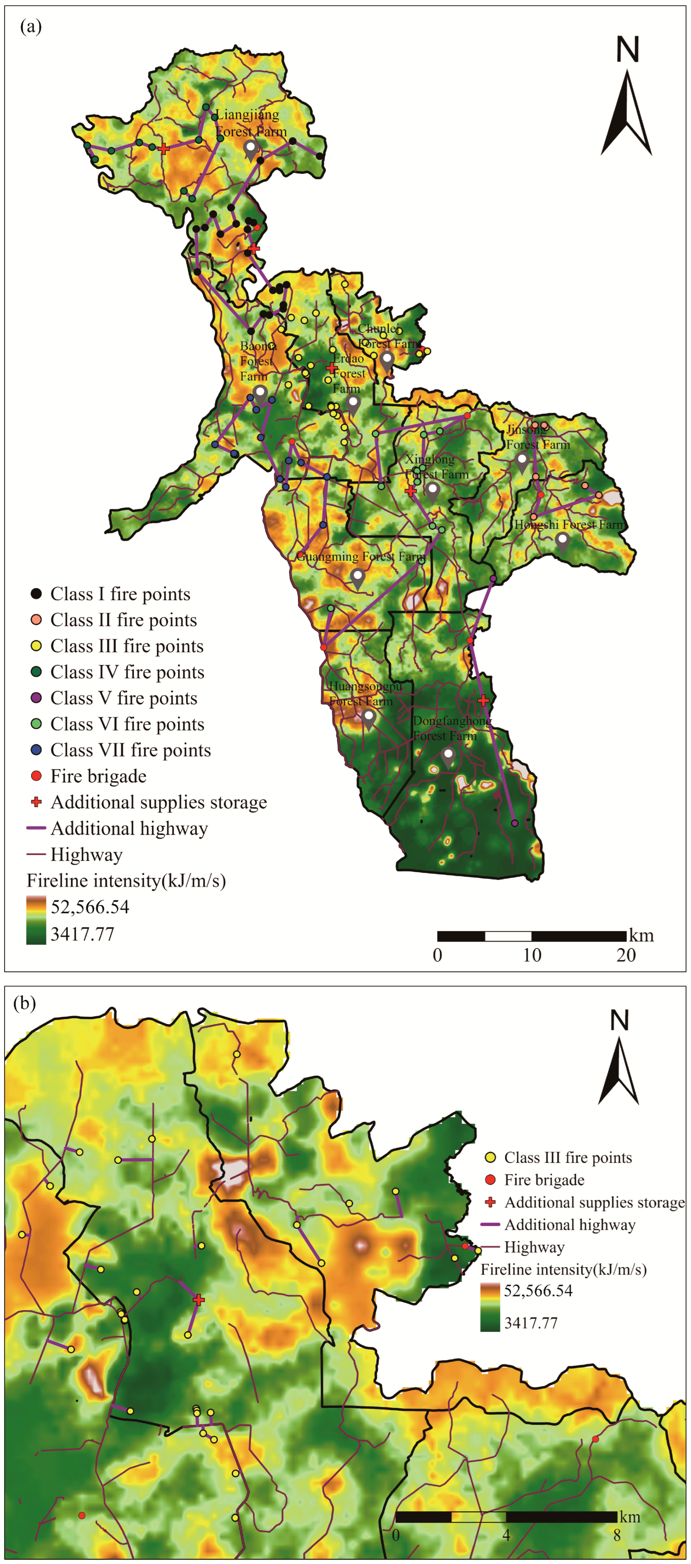
According to the highway network planning scheme derived from the PSO-TSP model, the PSO hyperparameters were set as follows: the individual learning factor was 0.1, the social learning factor was 0.075, and the inertia factor was 1. The road trajectories were generated using MATLAB (R2022b) and connected to the nearest points of the existing road network. In practice, the layout of the existing fire brigades, command organizations, and the spatial distribution of surface fireline intensity should also be fully integrated into the planning scheme (Figure 3a). Class III fire points are relatively dense, with higher fireline intensities concentrated in the northwest and northeast regions. Although these areas are largely covered by the existing road network, the K-means++ based planning scheme is suitable: constructing roads from the cluster centers to the existing network, and then extending them toward fire-prone regions. Considering the actual road conditions, some fire points are located closer to existing roads than to the cluster centers. In these cases, it is more efficient to build perpendicularly from these fire points to the nearest existing roads (Figure 3b).
Figure 3.
(a) Locations of fire points, fire brigades, supply storages, highways and planned highways; (b) Locations of fire points, fire brigades, supply storages, highways and planned highways of class III fire points.
Using ArcGIS Pro 3.0, the coordinates of cluster regions were extracted, and the required road length for each cluster was calculated (Table 5).
Table 5.
Road length (km) required for clustering area.
4. Discussion and Conclusions
4.1. Discussion
The rational allocation and optimization of emergency resources for forest fires are key to improving firefighting efficiency and formulating fire management strategies [41]. Based on the characteristics of forest fire occurrence and the quantification of fire behavior, this study optimized the layout of supply storages and the construction of additional firebreak roads in the Baihe Forestry Bureau of the Changbai Mountain forest region. The optimized allocation of emergency resources has a significant impact on both forest fire prevention and control and personnel safety [42]. Integrating the patterns of forest fire occurrence and spread with optimization techniques, while minimizing human and natural risks and ensuring efficient resource deployment, can further enhance the effectiveness of fire management [43]. As a long-protected pristine forest region, the Changbai Mountain forest region currently has a low frequency of forest fires. However, the substantial accumulation of fuel on the forest floor over many years, combined with intensified global warming, means that any unextinguished fire in its early stage is highly likely to develop into a large-scale, uncontrollable wildfire with severe damage [44,45]. Although the optimization results are derived from a relatively small spatial scale, the fuel characteristic data of major forest types were obtained through field surveys, which are more accurate and reliable than large-scale fuel data that are difficult to collect and usually estimated by calculation. Therefore, these results can provide a theoretical basis and methodological reference for relevant research in similar regions and at larger scales.
This study found that both forest fire frequency and surface fireline intensity in the Baihe Forestry Bureau show a clear pattern of being higher in the north and lower in the south. Among all forest farms, the Liangjiang Forest Farm in the northern part has the highest fire occurrence. This forest farm contains 8 administrative villages and 14 natural villages, forming a typical forest-agricultural interlaced zone where human activities are the main cause of forest fires [46,47]. Among the main fuel types, coniferous and broad-leaved mixed forests have the highest fireline intensity. As noted in studies by Bonner [48] and Berkey [49], mixed forests are prone to high-intensity surface fires due to their complex fuel structure and diverse composition; meanwhile, coniferous and broad-leaved mixed forest is the most widely distributed forest type in the Changbai Mountain forest region. To ensure that emergency supplies can be delivered to fire-affected areas quickly and effectively, thereby improving suppression efficiency and reducing fire losses [50], it is recommended to build additional forest fire supply storages in the northern part of the Baihe Forestry Bureau, including the Liangjiang Forest Farm and Erdao Forest Farm. Studies by Yan [51], Tabassum [52], Cihan [53] and others have also confirmed that the layout of supply storage plays a crucial role in disaster relief. At present, most forest areas focus heavily on ecological conservation but neglect the construction of basic support facilities such as supply storages [54]. In addition, existing supply storages are mostly located in administrative areas, far from remote forest zones. Although such areas have low fire frequency, delayed detection and complex terrain often lead to large-scale fires [55]. The optimization of supply storage proposed in this study fully considers wildfire occurrence and fire behavior and has almost achieved full coverage of high-risk wildfire areas. Relevant research by Falleiro [56] also indicates that increasing the number of forest firefighting facilities in a region can significantly reduce wildfire frequency and improve suppression efficiency. The Dongfanghong Forest Farm in the southern border area has a special geographical location. Despite the low current fire frequency and minimal damage, fire management systems in border areas differ greatly due to social, economic and administrative differences. In the event of a cross-border fire, response can only be carried out after the fire has crossed the border, which may miss the optimal suppression window and allow the fire to escalate into a major disaster [57,58].
Forest firebreak roads directly affect the prevention, monitoring, and suppression of forest fires, and determine whether firefighting teams can reach the fire scene rapidly [59]. For sudden disasters such as forest fires, response time is the most critical factor; reducing unnecessary delays creates more opportunities for effective control [60]. For example, fire services across the United States respond to a fire approximately every 20 s [61]. Research by Stefanović [62] also shows that in-depth optimization of the forest road network is essential for ensuring strong emergency response capacity for forest fires. At present, the forest road network within the jurisdiction of the Baihe Forestry Bureau generally meets operational needs. The optimization results show that the minimum length of additional roads to be constructed is only 13.46 km. Targeted road optimization in areas with high historical fire frequency and intense fire behavior can better meet the needs of forest firefighting. The complex terrain of pristine mountain forests makes road network construction difficult and costly [63], so traditional road planning often prioritizes production and transportation while ignoring fire prevention and emergency response requirements [64]. Optimizing road layouts in high-risk fire areas based on the existing road network is a key measure to improve the effectiveness of forest fire prevention [65]. In the construction of additional firebreak roads, full use should be made of the existing forest road network to minimize new construction and reduce vegetation damage [66]. In the long run, firebreak roads can act as fuel breaks to effectively slow the spread of forest fires and protect the ecological integrity of the Changbai Mountain ecosystem from the perspective of fire prevention and control [67]. The establishment of supply storage matches the fire prevention needs of the study area [7,43]. Scientific site selection limits potential negative ecological impact to a small scale, and the long-term ecological benefits of reducing wildfire damage are far more significant. Nevertheless, the optimization strategies proposed in this study still need to be verified and applied in actual forest fire response. In future research, the team will expand the study scope, incorporate more key factors affecting the management of forest fire emergency resources, and draw on typical wildfire cases to develop a large-scale forest fire prevention and control system suitable for the Changbai Mountain region.
4.2. Conclusions and Recommendations
Based on existing emergency resources and the risks of forest fire occurrence and spread, this study proposes a layout plan for supply storage and the expansion of the forest road network in the Baihe Forestry Bureau of the Changbai Mountain forest region. The results indicate that the overall risk of forest fire occurrence and development in the study area shows a higher-north-and-lower-south pattern, and natural coniferous-broadleaf mixed forests with complex fuel structures exhibit higher fire risks. Since the Changbai Mountain forest region has a high proportion of natural coniferous-broadleaf mixed forests with limited human management and substantial surface fuel accumulation, surface fuel management should be strengthened through scientific fuel cleaning, prescribed burning, and other measures to reduce forest fire risks. The existing forest road network in the study area meets the needs of daily production and livelihood, but it is still insufficient for forest fire suppression. This is particularly evident in areas with limited human disturbance and heavy fuel accumulation, where road coverage is inadequate to support rapid emergency response. Considering ecological protection and economic costs, road expansion should be carried out based on the current road network. The minimum length of new roads required is only 13.46 km, and adjustments can be made according to actual conditions. The construction of additional supply storage is more feasible than road network expansion. At present, no dedicated supply storage exists in the study area. According to the spatial distribution of forest fire risks and emergency response forces, five supply storages are recommended in Erdao Forest Farm, Liangjiang Forest Farm, Dongfanghong Forest Farm, and Xinglong Forest Farm. Unlike the traditional practice in most previous studies that locate supply storages near command centers, this study sites supply storage in non-command-center zones, which can significantly shorten the response distance and time to fire locations. Currently, most natural forest reserves such as the Changbai Mountain forest region focus heavily on ecological conservation and disaster prevention, yet the efficiency and timeliness of fire suppression also require greater attention. The optimization scheme proposed in this study not only balances ecological protection and economic cost control but also reduces emergency response time, improves the accessibility of logistical resources, and decreases the potential fire-affected area. It can provide a scientific reference for the optimal allocation of emergency resources in natural forest regions.
Author Contributions
Methodology, X.L. and Q.T.; Validation, T.M. and X.C.; Formal analysis, X.C. and S.F.; Investigation, X.L., S.F., T.M. and W.X.; Data curation, C.X. and Y.Z.; Writing—original draft, X.C.; Writing—review & editing, Y.S.; Supervision, Y.S. and S.Y. All authors have read and agreed to the published version of the manuscript.
Funding
This research was funded by the National Natural Science Foundation of China (Grant No. 32271881), the Graduate Innovation Program Project of Beihua University (2025-016), and the Undergraduate Innovation and Entrepreneurship Training Program Project of Beihua University (202510121257).
Data Availability Statement
The original contributions presented in the study are included in the article. Further inquiries can be directed to the corresponding author.
Conflicts of Interest
The authors declare no conflicts of interest.
References
- Cattau, M.E.; Wessman, C.; Mahood, A.; Balch, J.K. Anthropogenic and lightning-started fires are becoming larger and more frequent over a longer season length in the U.S.A. Glob. Ecol. Biogeogr. 2020, 29, 668–681. [Google Scholar] [CrossRef] [Scilit]
- Zhao, J.; Yue, C.; Wang, J.; Hantson, S.; Wang, X.; He, B.; Li, G.; Wang, L.; Zhao, H.; Luyssaert, S. Forest fire size amplifies postfire land surface warming. Nature 2024, 633, 828–834. [Google Scholar] [CrossRef] [Scilit] [PubMed]
- Bowman, D.M.J.S.; Williamson, G.J.; Abatzoglou, J.T.; Kolden, C.A.; Cochrane, M.A.; Smith, A.M.S. Human exposure and sensitivity to globally extreme wildfire events. Nat. Ecol. Evol. 2017, 1, 58. [Google Scholar] [CrossRef] [Scilit]
- Jetten, J.; Fielding, K.S.; Crimston, C.R.; Mols, F.; Haslam, S.A. Responding to climate change disaster: The case of the 2019/2020 bushfires in Australia. Eur. Psychol. 2021, 26, 161–171. [Google Scholar] [CrossRef] [Scilit]
- Shuman, J.K.; Balch, J.K.; Barnes, R.T.; Higuera, P.E.; Roos, C.I.; Schwilk, D.W.; Stavros, E.N.; Banerjee, T.; Bela, M.M.; Bendix, J.; et al. Reimagine fire science for the Anthropocene. PNAS Nexus 2022, 1, pgac115. [Google Scholar] [CrossRef] [Scilit]
- Li, M.; O’Hehir, J.; Jing, G.; Peters, S.; Hay, A. A theoretical framework for improved fire suppression by linking management models with smart early fire detection and suppression technologies. J. For. Res. 2024, 35, 86. [Google Scholar] [CrossRef] [Scilit]
- Mendes, A.B.; e Alvelos, F.P. A robust optimisation approach for the placement of forest fire suppression resources. Int. Trans. Oper. Res. 2025, 32, 1312–1342. [Google Scholar] [CrossRef] [Scilit]
- Yadav, N.; Rakholia, S.; Moore, P.; Ponce-Calderón, L.P.; S R, M.K.; Yosef, R. A Prototype Forest Fire Decision Support System for Uttarakhand, India. Fire 2025, 8, 149. [Google Scholar] [CrossRef] [Scilit]
- Lin, K.; Zhang, L.; Huang, L.; Feng, Z.; Chen, T. Improved particle swarm path planning algorithm with multi-factor coupling in forest fire spread scenarios. Fire 2023, 6, 202. [Google Scholar] [CrossRef] [Scilit]
- Ren, Y.; Tian, G. Emergency scheduling for forest fires subject to limited rescue team resources and priority disaster areas. IEEJ Trans. Electr. Electron. Eng. 2016, 11, 753–759. [Google Scholar] [CrossRef] [Scilit]
- Yang, J.; Guo, K.; Dai, Y.; Tian, S.; Wang, W.; Jiang, Z.; Dai, Z. Spatial layout siting method for fire stations based on comprehensive forest fire risk distribution. Case Stud. Therm. Eng. 2023, 49, 103243. [Google Scholar] [CrossRef] [Scilit]
- Uçar, Z. Determining a Safe Distance Zone for Firefighters Using a High-Resolution Global Canopy Height Dataset—A Case in Türkiye. Forests 2025, 16, 709. [Google Scholar] [CrossRef] [Scilit]
- Cosgun, U.; Coşkun, M.; Toprak, F.; Yıldız, D.; Coşkun, S.; Taşoğlu, E.; Öztürk, A. Visibility Evaluation and Suitability Analysis of Fire Lookout Towers in Mediterranean Region, Southwest Anatolia/Türkiye. Fire 2023, 6, 305. [Google Scholar] [CrossRef] [Scilit]
- Kucuk, O.; Topaloglu, O.; Altunel, A.O.; Cetin, M. Visibility analysis of fire lookout towers in the Boyabat State Forest Enterprise in Turkey. Environ. Monit. Assess. 2017, 189, 329. [Google Scholar] [CrossRef] [Scilit] [PubMed]
- Belval, E.J.; Pietruszka, B.M.; Viktora, A. The price of doing business: Severe injuries in wildland firefighters in the United States by activity performed and hazard encountered. Int. J. Wildland Fire 2025, 34, WF25038. [Google Scholar] [CrossRef] [Scilit]
- Steelman, T.; Nowell, B. Unpacking the pluralism paradox: Collaborative governance outcomes in jurisdictionally complex environments. Int. J. Wildland Fire 2025, 34, WF25013. [Google Scholar] [CrossRef] [Scilit]
- Fillmore, S.D.; McCaffrey, S.; Bean, R.; Evans, A.M.; Iniguez, J.; Thode, A.; Smith, A.M.S.; Thompson, M.P. Factors influencing wildfire management decisions after the 2009 US federal policy update. Int. J. Wildland Fire 2024, 33, WF23129. [Google Scholar] [CrossRef] [Scilit]
- Holtzclaw, T.; Newman, S.D.; Dwyer, M.; Simpson, J.; Goodwin, T. Coronavirus disease 2019 in the emergency department: Establishing an interprofessional incident command system. J. Emerg. Nurs. 2022, 48, 477–483. [Google Scholar] [CrossRef] [Scilit]
- Alawadhi, S. Developing an Incident Command System Framework for Natural Hazards in the United Arab Emirates (UAE); University of Salford: Salford, UK, 2019. [Google Scholar]
- Balik, J.A.; Coop, J.D.; Krawchuk, M.A.; Naficy, C.E.; Parisien, M.A.; Parks, S.A.; Stevens-Rumann, C.S.; Whitman, E. Biogeographic patterns of daily wildfire spread and extremes across North America. Front. For. Glob. Change 2024, 7, 1355361. [Google Scholar] [CrossRef] [Scilit]
- Cullen, A.C.; Goldgeier, B.R.; Belval, E.; Abatzoglou, J.A. Characterising ignition precursors associated with high levels of deployment of wildland fire personnel. J. Wildland Fire 2024, 33, WF23182. [Google Scholar] [CrossRef] [Scilit]
- Yuan, Z.; Ali, A.; Wang, S.; Wang, S.; Wang, X.; Lin, F.; Wang, Y.; Fang, S.; Hao, Z.; Loreau, M.; et al. Temporal stability of aboveground biomass is governed by species asynchrony in temperate forests. Ecol. Indic. 2019, 107, 105661. [Google Scholar] [CrossRef] [Scilit] [PubMed]
- Bai, J.; Tang, L.; Wang, Q.; Li, F. A Landscape-Scale Adjoining Conservation (LAC) Approach for Efficient Habitat Expansion: The Case of Changbai Mountain, Northeast China. Sustainability 2018, 10, 2919. [Google Scholar] [CrossRef] [Scilit]
- Parks, S.A.; Guiterman, C.H.; Margolis, E.Q.; Lonergan, M.; Whitman, E.; Abatzoglou, J.T.; Falk, D.A.; Johnston, J.D.; Daniels, L.D.; Lafon, C.W.; et al. A fire deficit persists across diverse North American forests despite recent increases in area burned. Nat. Commun. 2025, 16, 1493. [Google Scholar] [CrossRef] [Scilit] [PubMed]
- Qian, Y.; Meng, M.; Jie, D.; Gao, G.; Niu, H.; Yang, Z. Resilience of forests to past fire disturbance in the Changbai Mountains, Northeastern China. Glob. Planet. Change 2025, 255, 105080. [Google Scholar] [CrossRef] [Scilit]
- Ryan, K.C. Dynamic Interactions between Forest Structure and Fire Behavior in Boreal Ecosystems. Silva Fenn. 2002, 36, 13–39. [Google Scholar] [CrossRef] [Scilit]
- Jolly, M.W. Sensitivity of a surface fire spread model and associated fire behaviour fuel models to changes in live fuel moisture. Int. J. Wildland Fire 2007, 16, 503–509. [Google Scholar] [CrossRef] [Scilit]
- Patricia, L.A. Current status and future needs of the BehavePlus Fire Modeling System. Int. J. Wildland Fire 2014, 23, 21–33. [Google Scholar]
- Shalabi, L.A.; Shaaban, Z.; Kasasbeh, B. Data Mining: A Preprocessing Engine. J. Comput. Sci. 2006, 2, 735–739. [Google Scholar] [CrossRef] [Scilit]
- Bholowalia, P.; Kumar, A. EBK-Means: A clustering technique based on elbow method and K-Means in WSN. Int. J. Comput. Appl. 2014, 105, 17–24. [Google Scholar]
- Rouseeuw, P.J. Silhouettes: A graphical aid to the interpretation and validation of cluster analysis. J. Comput. Appl. Math. 1987, 20, 53–65. [Google Scholar] [CrossRef] [Scilit]
- Calinski, T.; Harabasz, J. A dendrite method for cluster analysis. Commun. Stat. 1974, 3, 1–27. [Google Scholar] [CrossRef] [Scilit]
- Tibshirani, R.; Walther, G.; Hastie, T. Estimating the number of clusters in a data set via the gap statistic. J. R. Stat. Soc. Ser. B 2001, 63, 411–423. [Google Scholar] [CrossRef] [Scilit]
- Davies, D.L.; Bouldin, D.W. A Cluster Separation Measure. IEEE Trans. Pattern Anal. Mach. Intell. 1979, 1, 224–227. [Google Scholar] [CrossRef] [Scilit] [PubMed]
- Macqueen, J.B. Some Methods for Classification and Analysis of Multivariate Observations. Proc. Berkeley Symp. Math. Stat. Probab. 1967, 1, 281–297. [Google Scholar]
- Lin, Y.; Tong, N.; Shi, M.; Fan, K.; Yuan, D.; Qu, L.; Fu, Q. K-means Optimization Clustering Algorithm Based on Particle Swarm Optimization and Multiclass Merging. Adv. Intell. Soft Comput. 2012, 168, 963–972. [Google Scholar]
- Zhu, G.; Ye, M.; Yu, X.; Liu, J.; Wang, M.; Luo, Z.; Liang, H.; Zhong, Y. Optimizing Route Planning via the Weighted Sum Method and Multi-Criteria Decision-Making. Mathematics 2025, 13, 1704. [Google Scholar] [CrossRef] [Scilit]
- Arora, S. Polynomial time approximation schemes for Euclidean traveling salesman and other geometric problems. J. ACM 1998, 45, 753–782. [Google Scholar] [CrossRef] [Scilit]
- Toaza, B.; Esztergár-Kiss, D. A review of metaheuristic algorithms for solving TSP-based scheduling optimization problems. Appl. Soft Comput. 2023, 148, 110908. [Google Scholar] [CrossRef] [Scilit]
- Scott, J.H. Off the Richter: Magnitude and intensity scales for wildland fire. In Proceedings of the 3rd International Fire Ecology and Management Congress: Changing Fire Regimes in the Context of Consequences, San Diego, CA, USA, 13–17 November 2006. [Google Scholar]
- Avci, M.G.; Avci, M.; Battarra, M.; Erdoğan, G. The wildfire suppression problem with multiple types of resources. Eur. J. Oper. Res. 2024, 316, 488–502. [Google Scholar] [CrossRef] [Scilit]
- Tezcan, B.; Özcan, N.A.; Özcan, E.; Eren, T. A Multi-Criteria Decision Model Proposal for the Selection of the Mobile Service Plant Problem After Earthquake: The Case of Kırıkkale. Int. J. Eng. Res. Dev. 2020, 12, 753–763. [Google Scholar] [CrossRef] [Scilit]
- Tezcan, B.; Eren, T. Forest fire management and fire suppression strategies: A systematic literature review. Nat. Hazards 2025, 121, 10485–10515. [Google Scholar] [CrossRef] [Scilit]
- Kreider, M.R.; Higuera, P.E.; Parks, S.A.; Rice, W.L.; White, N.; Larson, A.J. Fire suppression makes wildfires more severe and accentuates impacts of climate change and fuel accumulation. Nat. Commun. 2024, 15, 2412. [Google Scholar] [CrossRef] [Scilit]
- Nguyen, D.; Belval, E.J.; Wei, Y.; Calkin, D.E. A historical analysis of factors driving the daily prioritization of wildland fires in California. Int. J. Disaster Risk Reduct. 2026, 132, 105967. [Google Scholar] [CrossRef] [Scilit]
- Wu, Z.; He, H.S.; Keane, R.E.; Zhu, Z.; Wang, Y.; Shan, Y. Current and future patterns of forest fire occurrence in China. Int. J. Wildland Fire 2020, 29, 104–119. [Google Scholar] [CrossRef] [Scilit]
- Montoya Alvis, J.; Orozco Mendoza, G.L.; Zartha Sossa, J.W. Extreme Fire Events in Wildland–Urban Interface Areas: A Review of the Literature Concerning Determinants for Risk Governance. Sustainability 2025, 17, 4505. [Google Scholar] [CrossRef] [Scilit]
- Bonner, S.R.; Hoffman, C.M.; Linn, R.R.; Tinkham, W.T.; Atchley, A.L.; Sieg, C.H.; Varner, J.M.; O’Brien, J.J.; Hiers, J.K. Forest structural complexity and ignition pattern influence simulated prescribed fire effects. Fire Ecol. 2024, 20, 82. [Google Scholar] [CrossRef] [Scilit]
- Berkey, J.K.; Belote, R.T.; Maher, C.T.; Larson, A.J. Structural diversity and development in active fire regime mixed-conifer forests. For. Ecol. Manag. 2021, 479, 118548. [Google Scholar] [CrossRef] [Scilit]
- Amiri, A.B.; Asvadi, S. A prioritization model for locating relief logistic centers using analytic hierarchy process with interval comparison matrix. Knowl.-Based Syst. 2015, 86, 173–181. [Google Scholar] [CrossRef] [Scilit]
- Yan, X.X.; Hou, H.P.; Yang, J.L.; Fang, J. Site selection and layout of material reserve based on emergency demand graduation under large-scale earthquake. Sustainability 2021, 13, 1236. [Google Scholar] [CrossRef] [Scilit]
- Chowdhury, H.T.; Ghosh, S.; Mahamud, S.; Siddiqui, F.H.; Noor, S.B. Emergency resource storage facility location problem considering domino effect after a disaster. J. Humanit. Logist. Supply Chain Manag. 2023, 13, 365–377. [Google Scholar] [CrossRef] [Scilit]
- Cihan, C.; Eren, O.; Ilhan, K. A GIS-based AHP approach for emergency warehouse site selection: A case close to Turkey-Syria border. J. Eng. Res. 2022, 1, 250–273. [Google Scholar]
- Weidinger, J.; Schlauderer, S.; Overhage, S. Determinants for the acceptance of emergency response information systems: Ethnographical insights into the digitalization of a vuntary fire department. Int. J. Disaster Risk Reduct. 2024, 109, 104603. [Google Scholar] [CrossRef] [Scilit]
- Noroozi, F.; Ghanbarian, G.; Safaeian, R.; Ppurghasemi, H.R. Forest fire mapping: A comparison between GIS-based random forest and Bayesian models. Nat. Hazards 2024, 120, 6569–6592. [Google Scholar] [CrossRef] [Scilit]
- De Moraes Falleiro, R.; Rodovalho, F.V.; Zacharias, G.C.; Oliveira, G.C.; Schmidt, I.B.; Steil, L.; Carmenta, R. Wildfire protection in indigenous lands of Brazil: The role of fire brigades programs. Humanit. Soc. Sci. Commun. 2025, 13, 87. [Google Scholar] [CrossRef] [Scilit]
- Yan, K.; Zhao, F.; Liu, Y.; Shu, L.; Wang, M.; Si, L.; Li, W. Disparities in wildfire regimes across China’s borders: Picy-driven asymmetries in fire frequency, intensity and impact. Int. J. Disaster Risk Reduct. 2025, 131, 105922. [Google Scholar] [CrossRef] [Scilit]
- Alves, D.; Almeida, M.; Viegas, D.X.; Novo, I.; Luna, M.Y. Fire Danger Harmonization Based on the Fire Weather Index for Transboundary Events between Portugal and Spain. Atmosphere 2021, 12, 1087. [Google Scholar] [CrossRef] [Scilit]
- Zhang, F.; Zhao, P.; Xu, S.; Wu, Y.; Yang, X.; Zhang, Y. Integrating multiple factors to optimize watchtower deployment for wildfire detection. Sci. Total Environ. 2020, 737, 139561. [Google Scholar] [CrossRef] [Scilit] [PubMed]
- Zhou, J.F.; Reniers, G. Simulation analysis of the use of emergency resources during the emergency response to a major fire. J. Loss Prev. Process Ind. 2016, 44, 1–11. [Google Scholar] [CrossRef] [Scilit]
- Rahman, A.K.Z.R.; Sakif, S.M.N.; Sikder, N.; Masud, M.; Aljuaid, H.; Bairagi, A.K. Unmanned aerial vehicle assisted forest fire detection using deep convolutional neural network. Intell. Autom. Soft Comput. 2023, 35, 3259−3277. [Google Scholar] [CrossRef] [Scilit]
- Stefanovic, B.; Stojnic, D.; Danilovic, M. Multi-criteria forest road network planning in fire-prone environment: A case study in Serbia. J. Environ. Plan. Manag. 2016, 59, 911–926. [Google Scholar] [CrossRef] [Scilit]
- Banick, R.; Heyns, A.M.; Regmi, S. Evaluation of rural roads construction alternatives according to seasonal service accessibility improvement using a novel multi-modal cost-time model: A study in Nepal’s remote and mountainous Karnali province. J. Transp. Geogr. 2021, 93, 103057. [Google Scholar] [CrossRef] [Scilit]
- Laschi, A.; Foderi, C.; Fabiano, F.; Neri, F.; Cambi, M.; Mariotti, B.; Marchi, E. Forest Road Planning, Construction and Maintenance to Improve Forest Fire Fighting: A Review. Croat. J. For. Eng. 2019, 40, 207–219. [Google Scholar]
- Thompson, M.P.; Gannon, B.M.; Caggiano, M.D. Forest Roads and Operational Wildfire Response Planning. Forests 2021, 12, 110. [Google Scholar] [CrossRef] [Scilit]
- Aparício, B.A.; Ager, A.A.; Day, M.A. Maximizing opportunities for co-implementing fuel break networks and restoration projects. Front. For. Glob. Change 2024, 7, 1419288. [Google Scholar] [CrossRef] [Scilit]
- Bowring, S.P.K.; Li, W.; Mouillot, F.; Rosan, T.M.; Ciais, P. Road fragment edges enhance wildfire incidence and intensity, while suppressing global burned area. Nat. Commun. 2024, 15, 9176. [Google Scholar] [CrossRef] [Scilit] [PubMed]

Disclaimer/Publisher’s Note: The statements, opinions and data contained in all publications are solely those of the individual author(s) and contributor(s) and not of MDPI and/or the editor(s). MDPI and/or the editor(s) disclaim responsibility for any injury to people or property resulting from any ideas, methods, instructions or products referred to in the content. |
© 2026 by the authors. Licensee MDPI, Basel, Switzerland. This article is an open access article distributed under the terms and conditions of the Creative Commons Attribution (CC BY) license.