Next Issue
Volume 2, March
Previous Issue
Volume 1, September


Quaternary, Volume 1, Issue 3 (December 2018) – 14 articles

Cover Story (view full-size image): 
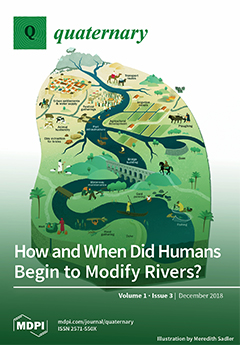
Rivers are central to landscape change and the Anthropocene because many human activities focused along waterways. The use of fire and gathering of plants and aquatic resources probably had little effect on rivers until crop cultivation intensified about 15,000 years ago in the Near East. Many plants and animals were domesticated worldwide after 10,700 years ago, leading locally within a millennium to organized agriculture with widespread legacy sediments, the first dams and irrigation, and mud-brick manufacture. Extensive irrigation systems and riverine settlements after about 6,500 years ago led to dams, urban water supplies, expanded groundwater use, river fleets, and alluvial mining, with major river engineering under the Chinese and Roman empires. Recent industrial effects have radically altered rivers worldwide. View this paper.
  • Issues are regarded as officially published after their release is announced to the table of contents alert mailing list.
  • You may sign up for e-mail alerts to receive table of contents of newly released issues.
  • PDF is the official format for papers published in both, html and pdf forms. To view the papers in pdf format, click on the "PDF Full-text" link, and use the free Adobe Reader to open them.
Order results
Result details
Select all
Export citation of selected articles as:
20 pages, 2733 KiB  
Article
Two Thousand Years of Land-Use and Vegetation Evolution in the Andean Highlands of Northern Chile Inferred from Pollen and Charcoal Analyses
by Alejandra I. Domic, José M. Capriles, Katerine Escobar-Torrez, Calogero M. Santoro and Antonio Maldonado
Quaternary 2018, 1(3), 32; https://doi.org/10.3390/quat1030032 - 19 Dec 2018
Cited by 19 | Viewed by 4908
Abstract
The European conquest of the New World produced major socio-environmental reorganization in the Americas, but for many specific regions and ecosystems, we still do not understand how these changes occurred within a broader temporal framework. In this paper, we reconstruct the long-term environmental [...] Read more.
The European conquest of the New World produced major socio-environmental reorganization in the Americas, but for many specific regions and ecosystems, we still do not understand how these changes occurred within a broader temporal framework. In this paper, we reconstruct the long-term environmental and vegetation changes experienced by high-altitude wetlands of the southcentral Andes over the last two millennia. Pollen and charcoal analyses of a 5.5-m-long core recovered from the semi-arid puna of northern Chile indicate that while climatic drivers influenced vegetation turnaround, human land use and management strategies significantly affected long-term changes. Our results indicate that the puna vegetation mostly dominated by grasslands and some peatland taxa stabilized during the late Holocene, xerophytic shrubs expanded during extremely dry events, and peatland vegetation persisted in relation to landscape-scale management strategies by Andean pastoralist societies. Environmental changes produced during the post-conquest period included the introduction of exotic taxa, such as clovers, associated with the translocation of exotic herding animals (sheep, cattle, and donkeys) and a deterioration in the management of highland wetlands. Full article
Show Figures

Graphical abstract

5 pages, 214 KiB  
Editorial
Quaternary Highlights (September–December 2018)
by Valentí Rull
Quaternary 2018, 1(3), 31; https://doi.org/10.3390/quat1030031 - 18 Dec 2018
Cited by 1 | Viewed by 2615
Abstract
Editorial summaries of selected papers relevant to Quaternary science published in high-impact multidisciplinary journals between 12 September and 10 December 2018. [...] Full article
30 pages, 5351 KiB  
Review
The Potential of Speleothems from Western Europe as Recorders of Regional Climate: A Critical Assessment of the SISAL Database
by Franziska A. Lechleitner, Sahar Amirnezhad-Mozhdehi, Andrea Columbu, Laia Comas-Bru, Inga Labuhn, Carlos Pérez-Mejías and Kira Rehfeld
Quaternary 2018, 1(3), 30; https://doi.org/10.3390/quat1030030 - 07 Dec 2018
Cited by 33 | Viewed by 7469
Abstract
Western Europe is the region with the highest density of published speleothem δ18O (δ18Ospel) records worldwide. Here, we review these records in light of the recent publication of the Speleothem Isotopes Synthesis and AnaLysis (SISAL) database. We [...] Read more.
Western Europe is the region with the highest density of published speleothem δ18O (δ18Ospel) records worldwide. Here, we review these records in light of the recent publication of the Speleothem Isotopes Synthesis and AnaLysis (SISAL) database. We investigate how representative the spatial and temporal distribution of the available records is for climate in Western Europe and review potential sites and strategies for future studies. We show that spatial trends in precipitation δ18O are mirrored in the speleothems, providing means to better constrain the factors influencing δ18Ospel at a specific location. Coherent regional δ18Ospel trends are found over stadial-interstadial transitions of the last glacial, especially in high altitude Alpine records, where this has been attributed to a strong temperature control of δ18Ospel. During the Holocene, regional trends are less clearly expressed, due to lower signal-to-noise ratios in δ18Ospel, but can potentially be extracted with the use of statistical methods. This first assessment highlights the potential of the European region for speleothem palaeoclimate reconstruction, while underpinning the importance of knowing local factors for a correct interpretation of δ18Ospel. Full article
(This article belongs to the Special Issue Speleothem Records and Climate)
Show Figures

Figure 1

25 pages, 7598 KiB  
Review
The Indian Summer Monsoon from a Speleothem δ18O Perspective—A Review
by Nikita Kaushal, Sebastian F. M. Breitenbach, Franziska A. Lechleitner, Ashish Sinha, Vinod C. Tewari, Syed Masood Ahmad, Max Berkelhammer, Shraddha Band, Madhusudan Yadava, Rengaswamy Ramesh and Gideon M. Henderson
Quaternary 2018, 1(3), 29; https://doi.org/10.3390/quat1030029 - 07 Dec 2018
Cited by 41 | Viewed by 8839
Abstract
As one of the most prominent seasonally recurring atmospheric circulation patterns, the Asian summer monsoon (ASM) plays a vital role for the life and livelihood of about one-third of the global population. Changes in the strength and seasonality of the ASM significantly affect [...] Read more.
As one of the most prominent seasonally recurring atmospheric circulation patterns, the Asian summer monsoon (ASM) plays a vital role for the life and livelihood of about one-third of the global population. Changes in the strength and seasonality of the ASM significantly affect the ASM region, yet the drivers of change and the varied regional responses of the ASM are not well understood. In the last two decades, there were a number of studies reconstructing the ASM using stalagmite-based proxies such as oxygen isotopes (δ18O). Such reconstructions allow examination of ASM drivers and responses, increasing monsoon predictability. In this review paper, we focus on stalagmite δ18O records from India at the proximal end of the ASM region. Indian stalagmite δ18O records show well-dated, high-amplitude changes in response to the dominant drivers of the ASM on orbital to multi-centennial timescales, and indicate the magnitude of monsoon variability in response to these drivers. We examine Indian stalagmite records collated in the Speleothem Isotope Synthesis and AnaLysis version 1 (SISAL_v1) database (http://researchdata.reading.ac.uk/139/) and support the database with a summary of record quality and regional climatic interpretations of the δ18O record during different climate states. We highlight current debates and suggest the most useful time periods (climatic events) and locations for further work using tools such as data-model comparisons, spectral analysis methods, multi-proxy investigations, and monitoring. Full article
(This article belongs to the Special Issue Speleothem Records and Climate)
Show Figures

Figure 1

27 pages, 5548 KiB  
Review
The Influence of Crustal Properties on Patterns of Quaternary Fluvial Stratigraphy in Eurasia
by Tuncer Demir, Rob Westaway and David Bridgland
Quaternary 2018, 1(3), 28; https://doi.org/10.3390/quat1030028 - 05 Dec 2018
Cited by 6 | Viewed by 3783
Abstract
Compilation of empirical data on river-terrace sequences from across Eurasia during successive International Geoscience Programme (IGCP) projects revealed marked contrasts between the records from different crustal provinces, notably between the East European Platform (EEP) and the Caledonian/Variscan/Alpine provinces of western/central Europe. Well-developed terrace [...] Read more.
Compilation of empirical data on river-terrace sequences from across Eurasia during successive International Geoscience Programme (IGCP) projects revealed marked contrasts between the records from different crustal provinces, notably between the East European Platform (EEP) and the Caledonian/Variscan/Alpine provinces of western/central Europe. Well-developed terrace staircases, often indicative of hundreds of metres of Late Cenozoic uplift/fluvial incision, are preserved in many parts of the European continent, especially westward of the EEP. In contrast, rivers within the EEP have extensive sedimentary archives that are not preserved as terrace staircases; instead, they form sets of laterally accreted sediment packages, never more than a few tens of metres above or below modern river level. There are parallels in Asia, albeit that the crust of the Asian continent has a greater proportion of tectonically active zones, at one extreme, and stable platforms/cratons at the other. The observed patterns point strongly to the mobility of lower-crustal material within younger provinces, where the continental crust is significantly hotter, as a key part of the mechanism driving the progressive uplift that has led to valley incision and the formation of river terraces: a process of erosional isostasy with lower-crustal flow as a positive-feedback driver. The contrast between these different styles of fluvial-archive preservation is of considerable significance for Quaternary stratigraphy, as such archives provide important templates for the understanding of the terrestrial record. Full article
(This article belongs to the Special Issue Special External Effects on Fluvial System Evolution)
Show Figures

Figure 1

3 pages, 191 KiB  
Editorial
Specific Exogenetic (External) and Endogenetic (Internal) Effects on Fluvial System Evolution
by Jef Vandenberghe, David Bridgland and Xianyan Wang
Quaternary 2018, 1(3), 27; https://doi.org/10.3390/quat1030027 - 26 Nov 2018
Cited by 6 | Viewed by 2360
Abstract
A collection of papers appears under the title “Special External Effects on Fluvial System Evolution” in the journal, Quaternary. This is a new Special Issue under the aegis of the Fluvial Archives Group (FLAG), illustrating the recent progress made in paleo-fluvial research. [...] Read more.
A collection of papers appears under the title “Special External Effects on Fluvial System Evolution” in the journal, Quaternary. This is a new Special Issue under the aegis of the Fluvial Archives Group (FLAG), illustrating the recent progress made in paleo-fluvial research. These papers highlight the high complexity of the external forcing of fluvial dynamics, and especially, the combined results of several interfering variables. In addition, it appears that the study of fluvial archives cannot be limited to the general and direct effects of external variables, but it also has to include the indirect influences that are regionally variable. Full article
(This article belongs to the Special Issue Special External Effects on Fluvial System Evolution)
8 pages, 210 KiB  
Editorial
Advances in Quaternary Studies: The Contribution of the Mammalian Fossil Record
by Maria Rita Palombo
Quaternary 2018, 1(3), 26; https://doi.org/10.3390/quat1030026 - 23 Nov 2018
Cited by 1 | Viewed by 2816
Abstract
Explaining the multifaceted, dynamic interactions of the manifold factors that have modelled throughout the ages the evolutionary history of the biosphere is undoubtedly a fascinating and challenging task that has been intriguing palaeontologists, biologists and ecologists for decades, in a never-ending pursuit of [...] Read more.
Explaining the multifaceted, dynamic interactions of the manifold factors that have modelled throughout the ages the evolutionary history of the biosphere is undoubtedly a fascinating and challenging task that has been intriguing palaeontologists, biologists and ecologists for decades, in a never-ending pursuit of the causal factors that controlled the evolutionary dynamics of the Earth’s ecosystems throughout deep and Quaternary time. [...] Full article
20 pages, 4074 KiB  
Article
A Macroscopic Charcoal and Multiproxy Record from Peat Recovered from Depression Marshes in Longleaf Pine Sandhills, Florida, USA
by Benjamin Tanner, Morgan Douglas, Cathryn H. Greenberg, Jessica Chamberlin and Diane Styers
Quaternary 2018, 1(3), 25; https://doi.org/10.3390/quat1030025 - 19 Nov 2018
Cited by 8 | Viewed by 3844
Abstract
Science-based information on historical fire frequency is lacking for longleaf pine sandhills. We undertook a high-resolution macroscopic charcoal and geochemical analysis of sediment cores recovered from three depression marshes located within a longleaf pine sandhill ecosystem in Florida, USA. A ~1500-year fire history [...] Read more.
Science-based information on historical fire frequency is lacking for longleaf pine sandhills. We undertook a high-resolution macroscopic charcoal and geochemical analysis of sediment cores recovered from three depression marshes located within a longleaf pine sandhill ecosystem in Florida, USA. A ~1500-year fire history reconstructed from >1.5 m length peat cores analyzed at decadal to multi-decadal resolution revealed abundant macroscopic charcoal particles at nearly all sampling intervals, suggesting that fire occurred near the sites for almost all decades represented in the deposit. This result supported previous hypotheses of a frequent natural fire return interval for Florida’s longleaf pine sandhills and suggested that management decisions for this ecosystem should continue to focus on the frequent prescription of controlled burns. Our research also demonstrated that some of Florida’s depression marshes contain a >3000-year archive of organic-rich peat. Bulk elemental carbon and nitrogen data and stable carbon isotope analysis of the deposits at two of the three study sites suggested persistently wet soils. Soil data from the third site suggested that drying and peat oxidation occurred periodically. These depression marshes rapidly sink carbon, with measured sequestration rates on the order of 16 to 56 g m−2 yr−1. Our research demonstrated that Florida’s depression marshes provide an untapped record of paleoenvironmental information. Full article
(This article belongs to the Special Issue Feature Papers in Quaternary)
Show Figures

Figure 1

7 pages, 228 KiB  
Editorial
What If the ‘Anthropocene’ Is Not Formalized as a New Geological Series/Epoch?
by Valentí Rull
Quaternary 2018, 1(3), 24; https://doi.org/10.3390/quat1030024 - 19 Oct 2018
Cited by 12 | Viewed by 4723
Abstract
In the coming years, the Anthropocene Working Group (AWG) will submit its proposal on the ‘Anthropocene’ to the Subcommission of Quaternary Stratigraphy (SQS) and the International Commission on Stratigraphy (ICS) for approval. If approved, the proposal will be sent to the Executive Committee [...] Read more.
In the coming years, the Anthropocene Working Group (AWG) will submit its proposal on the ‘Anthropocene’ to the Subcommission of Quaternary Stratigraphy (SQS) and the International Commission on Stratigraphy (ICS) for approval. If approved, the proposal will be sent to the Executive Committee of the International Union of Geological Sciences (IUGS) for ratification. If the proposal is approved and ratified, then the ‘Anthropocene’ will be formalized. Currently, the ‘Anthropocene’ is a broadly used term and concept in a wide range of scientific and non-scientific situations, and, for many, the official acceptance of this term is only a matter of time. However, the AWG proposal, in its present state, seems to not fully meet the requirements for a new chronostratigraphic unit. This essay asks what could happen if the current ‘Anthropocene’ proposal is not formalized by the ICS/IUGS. The possible stratigraphic alternatives are evaluated on the basis of the more recent literature and the personal opinions of distinguished AWG, SQS, and ICS members. The eventual impact on environmental sciences and on non-scientific sectors, where the ‘Anthropocene’ seems already firmly rooted and de facto accepted as a new geological epoch, are also discussed. This essay is intended as the editorial introduction to a Quaternary special issue on the topic. Full article
20 pages, 3636 KiB  
Article
Climatically-Controlled River Terraces in Eastern Australia
by James S. Daley and Tim J. Cohen
Quaternary 2018, 1(3), 23; https://doi.org/10.3390/quat1030023 - 16 Oct 2018
Cited by 10 | Viewed by 4551
Abstract
In the tectonically stable rivers of eastern Australia, changes in response to sediment supply and flow regime are likely driven by both regional climatic (allogenic) factors and intrinsic (autogenic) geomorphic controls. Contentious debate has ensued as to which is the dominant factor in [...] Read more.
In the tectonically stable rivers of eastern Australia, changes in response to sediment supply and flow regime are likely driven by both regional climatic (allogenic) factors and intrinsic (autogenic) geomorphic controls. Contentious debate has ensued as to which is the dominant factor in the evolution of valley floors and the formation of late Quaternary terraces preserved along many coastal streams. Preliminary chronostratigraphic data from river terraces along four streams in subtropical Southeast Queensland (SEQ), Australia, indicate regionally synchronous terrace abandonment between 7.5–10.8 ka. All optically stimulated luminescence ages are within 1σ error and yield a mean age of incision at 9.24 ± 0.93 ka. Limited samples of the upper parts of the inset floodplains from three of the four streams yield near-surface ages of 600–500 years. Terrace sediments consist of vertically accreted fine sandy silts to cohesive clays, while top stratum of the floodplains are comprised of clay loams to fine-medium sands. The inundation frequency of these alluvial surfaces depends on their specific valley setting. In narrow valley settings, where floodplains comprise <5% of the valley floor, terraces are inundated between the 20 and 50-year annual exceedance probability (AEP) flood, while in wide settings (floodplains >20%), the terraces are no longer inundated. Floodplain inundation frequencies also vary between these settings by an order of magnitude between 5- to 50-year AEP, respectively. The correlation of terrace abandonment within SEQ with fluvial and palaeoenvironmental records elsewhere in the subtropics, and more broadly across eastern Australia, are an indication that terrace abandonment has primarily been driven by climatic forcing. Contemporaneous channel incision in the early Holocene may have been driven by an increasingly warmer and wetter environment in SEQ, with a climate commensurate with the delivery of more extreme weather events. Following channel incision, many streams in SEQ have been largely confined to their entrenched “macrochannel” form that remains preserved within the valley floor. Full article
(This article belongs to the Special Issue Special External Effects on Fluvial System Evolution)
Show Figures

Figure 1

25 pages, 3126 KiB  
Article
ESR Dating Ungulate Teeth and Molluscs from the Paleolithic Site Marathousa 1, Megalopolis Basin, Greece
by Bonnie A. B. Blackwell, Neeraj Sakhrani, Impreet K. Singh, Kalyani K. Gopalkrishna, Vangelis Tourloukis, Eleni Panagopoulou, Panagiotis Karkanas, Joel I. B. Blickstein, Anne R. Skinner, Jonathan A. Florentin and Katerina Harvati
Quaternary 2018, 1(3), 22; https://doi.org/10.3390/quat1030022 - 15 Oct 2018
Cited by 11 | Viewed by 3656
Abstract
At 37°24′ N 22°8′ E, the Megalopolis Basin lies in the central Peloponnese Peninsula, southwestern Greece. In the Megalopolis Basin at ~350 m amsl, the Paleolithic site, Marathousa 1, sits within a palustrine/lacustrine clastic package between Lignite Seams III and II, that both [...] Read more.
At 37°24′ N 22°8′ E, the Megalopolis Basin lies in the central Peloponnese Peninsula, southwestern Greece. In the Megalopolis Basin at ~350 m amsl, the Paleolithic site, Marathousa 1, sits within a palustrine/lacustrine clastic package between Lignite Seams III and II, that both likely correlate with interglacial periods. At Marathousa 1, immediately below Lignite Seam III, lies a clayey-silty sand layer with a horizon rich in molluscs ranging from ~20–40 cm thick. About 0.8–1.3 m below the shell-rich horizon (SRH), lacustrine silty to muddy sands rich in organic matter yielded Paleolithic lithic artefacts associated with Middle Pleistocene fauna, some with cut marks and possible bone knapping, found within palustrine/lacustrine clastic deposits. Since ESR (electron spin resonance) can date teeth and molluscs aged >2 Ma, two bivalve samples, AM66 and AM65, five subsamples from a cervid molar, AT39, and one subsample from another cervid molar, AT68, were independently dated by ESR from Marathousa 1. To calculate the ages, time-averaged cosmic and time- and volumetrically-averaged sedimentary dose rates were calculated using past water depths and sedimentation rates as determined from paleontological and geological criteria. Found in the SRH in Layer UA2, AM66 and AM65 averaged 488 ± 37 ka, which correlates with MIS 13a. Because the bivalves sat stratigraphically above the artefacts and mammalian fossils, their ages constrain the ESR ages for the teeth deposited below. Lying on the unconformity at the base of Layer UA3c with UA4, and its correlative unconformity at the Layer UB4c/UB5 boundary, sat the dated teeth from large mammals. Because the bones in the Palaeoloxodon antiquus skeleton lay in quasi-anatomical association, the likelihood for fossil reworking on the Layer UB3c/UB4 surface is low. Isochron analysis suggests that using a U uptake model with p = 2 provides the most accurate ages for AT39. With p = 2, AT39 dates to 503 ± 13 ka, while AT68 dates to 512 ± 34 ka. Nonetheless, two to three more teeth and molluscs should be dated to confirm these ages, when more samples suitable for ESR dating are found. Both tooth ages correlate well with early MIS 13, an interglacial period with cooler mean global temperatures compared to MIS 11 or 9. Assuming that the archaeological site formed in one event, rather than as a palimpsest, the data suggest that hominins processed elephant and other faunal carcasses along the shores of a shallow lake or marsh in the Megalopolis Basin at 503 ± 12 ka. Between the two horizons dated here, their sedimentation rate averaged 4.8 ± 1.8 to 7.8 ± 2.9 cm/ka. Full article
(This article belongs to the Special Issue Feature Papers in Quaternary)
Show Figures

Figure 1

37 pages, 43405 KiB  
Article
River Systems and the Anthropocene: A Late Pleistocene and Holocene Timeline for Human Influence
by Martin R. Gibling
Quaternary 2018, 1(3), 21; https://doi.org/10.3390/quat1030021 - 04 Oct 2018
Cited by 34 | Viewed by 15271
Abstract
Rivers are central to debate about the Anthropocene because many human activities from antiquity focused on channels and floodplains. A literature compilation for the onset of human modification of rivers identifies six stages that represent key innovations focused in the Near East and [...] Read more.
Rivers are central to debate about the Anthropocene because many human activities from antiquity focused on channels and floodplains. A literature compilation for the onset of human modification of rivers identifies six stages that represent key innovations focused in the Near East and adjoining areas: (1) minimal effects before about 15,000 cal yr BP, with the use of fire and gathering of plants and aquatic resources; (2) minor effects from increased cultivation after about 15,000 cal yr BP, with plant and animal domestication after about 10,700 cal yr BP; (3) agricultural era after about 9800 cal yr BP, with legacy sediments, widespread fire use, the first dams and irrigation, and mud-brick manufacture; (4) irrigation era from about 6500 cal yr BP, with large-scale irrigation, major cities, the first large dam, urban water supplies, expanded groundwater use, river fleets, and alluvial mining; (5) engineering era with embankments, dams, and watermills after about 3000 cal yr BP, especially in the Chinese and Roman empires; and (6) technological era after about 1800 CE. Anthropogenic river effects were more varied and intense than commonly has been recognised, and they should be considered routinely in interpreting Late Pleistocene and Holocene fluvial archives. Full article
(This article belongs to the Special Issue Special External Effects on Fluvial System Evolution)
Show Figures

Graphical abstract

19 pages, 4136 KiB  
Article
Identifying Past Remains of Morphologically Similar Vole Species Using Molar Shapes
by Nicolas Navarro, Sophie Montuire, Rémi Laffont, Emilie Steimetz, Catalina Onofrei and Aurélien Royer
Quaternary 2018, 1(3), 20; https://doi.org/10.3390/quat1030020 - 27 Sep 2018
Cited by 15 | Viewed by 3756
Abstract
Accurate species identification in fossil remains is a complex task but is a key component for developing good inferences on many, if not all, fundamental questions in macroecology and macroevolution. In the Quaternary, arvicolines are very abundant remains in archeological and paleontological sites [...] Read more.
Accurate species identification in fossil remains is a complex task but is a key component for developing good inferences on many, if not all, fundamental questions in macroecology and macroevolution. In the Quaternary, arvicolines are very abundant remains in archeological and paleontological sites in Western Europe and their identification is often based on the first lower molar. The common vole Microtus arvalis (Pallas, 1778) and the field vole Microtus agrestis (Linnaeus, 1761) are commonly found in those deposits. These two species are genetically and ecologically divergent. Nonetheless, their lower molars, on which species identification is done, exhibit a large morphological variation that can potentially lead to some confusion and misinterpretation. Moreover, molecular data suggest that present-day M. agrestis populations are a complex of divergent lineages, some of them being recognized nowadays as valid species. On the basis of extant populations representing a large part of the present-day geographical distribution of these two species, we developed a classification model based on geometric morphometrics of the first lower molar. Our statistical model was then applied on four fossil sites selected to evaluate the relevance of taxonomic determination found in species lists. The model using landmarks describing the overall shape of the first lower molar classifies the two species with the smallest prediction error together with very high individual posterior probabilities. The obtained classification is much better than those arising from shapes of any specific molar part such as the anterior loop, asymmetry or peculiar triangle shape. Discrepancies with expert classification on fossils suggest that existing faunal lists should always be considered cautiously for these two species. Our morphometric model provides a first step towards a rationalized way of revising past collections and expertise for future small mammal assemblages. It will thus help us better understand the paleobiogeographical expansion of these two key species in Quaternary faunas. Full article
Show Figures

Figure 1

47 pages, 12399 KiB  
Article
New Insights into the LGM and LG in Southern France (Vaucluse): The Mustelids, Micromammals and Horses from Coulet des Roches
by Evelyne Crégut-Bonnoure, Nicolas Boulbes, Emmanuel Desclaux and Adrian Marciszak
Quaternary 2018, 1(3), 19; https://doi.org/10.3390/quat1030019 - 27 Sep 2018
Cited by 14 | Viewed by 5498
Abstract
Coulet des Roches is a natural karst trap in Southern France. Its infilling dates back to the end of the Pleniglacial (Last Glacial Maximum, LGM) and the end of the Tardiglacial (Last Glacial, LG). Three mustelid species have been identified in this infilling: [...] Read more.
Coulet des Roches is a natural karst trap in Southern France. Its infilling dates back to the end of the Pleniglacial (Last Glacial Maximum, LGM) and the end of the Tardiglacial (Last Glacial, LG). Three mustelid species have been identified in this infilling: the common polecat (Mustela putorius, minimum number of individuals (MNI) = 4), the stoat (Mustela erminea, MNI = 14) and the weasel (Mustela nivalis, MNI = 48). The common polecat remains are metrically and morphologically indistinguishable from recent European specimens. The smallest mustelids are mainly represented by average-sized specimens, which are slightly smaller than extant species. A partial weasel skeleton of an extremely small pygmy weasel, regarded as a typical glacial element, was also discovered. Sexual dimorphism is strongly pronounced. Seventeen horses have been identified, corresponding to the chrono subspecies Equus ferus gallicus. The analysis of the muzzles and metapodials shows overall adaptation to cool and dry weather conditions. The ibexes are typical of Capra ibex (MNI = 15). The p3 morphology is similar to the LGM populations located on the southern side of the Durance River, with an important dilation of the metaconid, except for the oldest LGM specimen. This dilation is older on the southern side of the Durance River, as it occurs at the end of MIS 3. This difference could reflect the barrier role of the Durance River. Micromammals are abundant (mostly related to rodents and shrews; 18 genera/species; MNI = 470). The paleoecological study highlighted important and rapid climatic and environmental fluctuations throughout the sequence. As a result of climatic fluctuations, the plains constituted a corridor for the migration of temperate species to Provence during cold periods (“southern refuge zone”) and their re-immigration to Western Europe during temperate episodes. In a related and complementary way, the highland areas not only played a natural role as a geographical barrier, but also constituted a refuge zone during interglacial episodes for some micromammal species originating from northern and eastern parts of Europe (“cryptic southern refugia”). Full article
Show Figures

Figure 1

Previous Issue
Next Issue
Back to TopTop