


Highlights
What are the main findings?
- UAV-borne low-frequency GPR detected a key sliding surface at ~10 m depth.
- Joint UAV-GPR/LiDAR integration improved finding accuracy and structural interpretation.
What are the implications of the main findings?
- UAV geophysics surveys enable subsurface imaging in vegetated or inaccessible slopes.
- Integrated surface–subsurface datasets improve the characterization of slope deformation processes.
Abstract
Investigating slope deformation in densely vegetated or remote areas is a major challenge for slope stability assessment. This study introduces and validates an integrated UAV-borne low-frequency Ground Penetrating Radar (UAV-GPR) and LiDAR methodology to characterize an unstable slope in Melizzano, Southern Italy. Radar data were acquired along an east–west transect at ~1 m above ground level, while high-resolution LiDAR were used to generate a detailed Digital Terrain Model for topographic correction and geomorphological analysis. The processed radargram images subsurface features down to ~15 m, revealing a laterally continuous high-amplitude reflector at ~10 m, interpreted as a key main sliding surface. Chaotic reflections above this interface indicate heterogeneous deposits associated with gravitational deformation, while more homogeneous reflections below correspond to stable geological units. The geometry of the reflector suggests a compound landslide mechanism. Borehole data validate the geophysical interpretation, showing depth discrepancies lower than 2 m. The integration of UAV-GPR and LiDAR enables a reliable correlation between surface morphology and subsurface structures. This non-invasive, spatially continuous approach provides an effective framework for subsurface characterization and for improving the interpretation of landslide geometry and internal structure in challenging environments. This study demonstrates the capability of low-frequency UAV-borne GPR to detect deep-seated sliding surfaces (>10 m) in vegetated environments when integrated with high-resolution LiDAR topography.
1. Introduction
Slope deformation processes are among the most widespread natural hazards in Italy and represent a major source of hydrogeological risk [1,2]. The complex geological and geomorphological framework of the Italian territory, combined with intense rainfall regimes and human-induced landscape modifications, contributes to the frequent occurrence of slope instability phenomena [3,4,5,6,7]. An accurate characterization of these processes, particularly the identification of sliding surfaces and the internal structure of involved geological units, is essential for effective hazard assessment and risk mitigation [6,8].
Traditional investigation techniques, including borehole stratigraphic logs and direct field surveys, often provide limited spatial coverage and may be difficult to implement in areas characterized by dense vegetation, steep slopes, or poor accessibility. In this context, geophysical methods represent valuable tools for supporting the investigation of subsurface conditions without invasive soundings [9,10,11].
Ground Penetrating Radar (GPR) has been widely used for shallow subsurface imaging and for detecting subsurface discontinuities associated with geological structures or slope deformation processes [12,13]. However, conventional ground-based GPR surveys typically require direct near-contact between the antenna and the ground surface, which can significantly limit their applicability in environments characterized by dense vegetation or irregular terrain. Recent advances in Unmanned Aerial Vehicle (UAV) technologies have opened new opportunities for geophysical exploration. UAV platforms allow the deployment of tools in complex terrain and enable low-altitude surveys with high spatial flexibility. The use of UAV-borne geophysical instruments makes it possible to acquire subsurface data in areas where traditional ground-based surveys are impractical or unsafe [10,14,15]. UAV-based LiDAR (Light Detection and Ranging) technology provides high-resolution topographic data that are particularly useful for detecting subtle geomorphological features associated with gravitative slope deformation processes [9,16]. Recent studies have also demonstrated the versatility of UAVs for geological and landslide investigations, including multi-sensor mapping of slope instabilities and combined geomorphological and geophysical monitoring of unstable areas [17,18]. Despite the growing use of UAV platforms for remote sensing and geophysical applications, the use of low-frequency UAV-borne GPR for landslide investigations remains limited. In particular, its application to detect deep-seated sliding surfaces in vegetated environments is still poorly documented [6,19,20,21,22]. Furthermore, only a limited number of studies have explored the integration of UAV-GPR data with high-resolution UAV-LiDAR topography for the combined analysis of surface morphology and corresponding subsurface stratigraphic structures. These limitations highlight the need for integrated methodologies capable of simultaneously imaging slope features both at the surface and at depth [23,24].
In this context, the present study investigates the internal structure of a shallow portion of a dormant landslide located in the municipality of Melizzano (Southern Italy), through the integration of UAV-borne low-frequency GPR data and UAV-based LiDAR topographic data. The main objectives of the research are: (i) to identify the depth and geometry of possible sliding surfaces; (ii) to reconstruct the internal structure of the involved geological units; and (iii) to evaluate the potential of integrated UAV-based geophysical techniques.
This study addresses a critical methodological gap: the lack of validated workflows integrating low-frequency UAV-GPR with high-resolution UAV-LiDAR for resolving deep-seated landslide geometries (>10 m) in vegetated environments. The proposed approach is tested on a real case study and provides quantitative constraints on sliding surface depth and geometry.
Geological and Geographical Setting
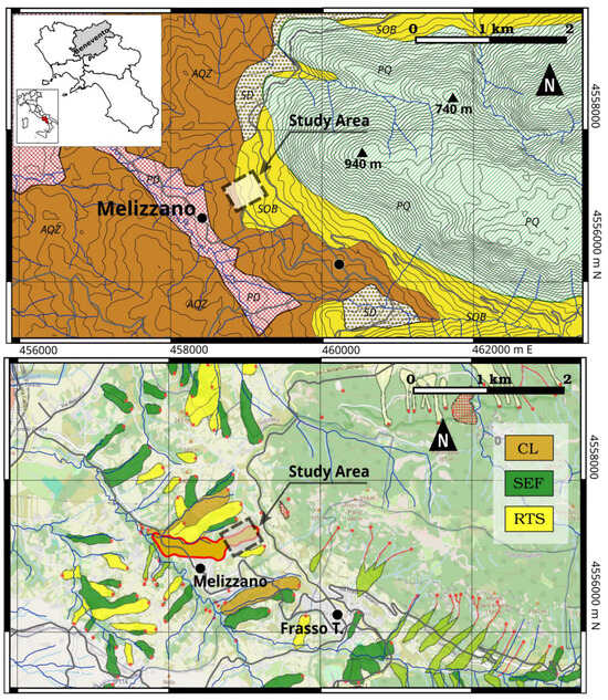
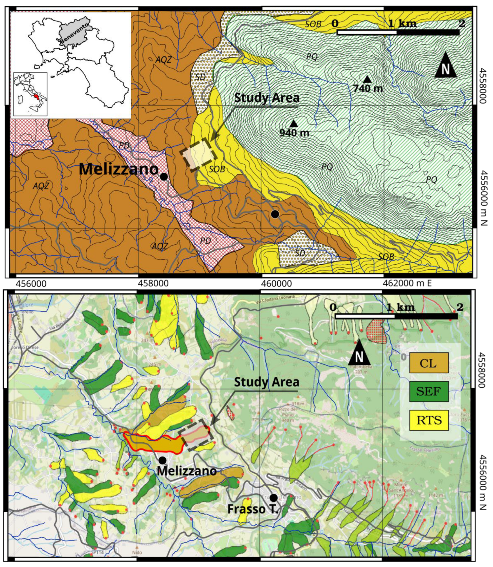
The study area is located in the municipality of Melizzano, in the province of Benevento, within the Campania region of southern Italy. This area has been selected on the basis of field evidence of active ground deformation, related to gravity-driven processes (Figure 1).
Figure 1.
Geographic, geomorphological, and geological setting of the study area, showing the portion of investigated slope in Melizzano (Southern Italy). Landslides known in the area were derived from the Italian Landslide Inventory (IFFI); they are also shown (lower panel; ID 0620223700, outlined in red): CL: complex landslide; SEF: slow earthflow; RTS: rotational/translational slide. Geological framework: Bonea Subsynthem (SOB), mainly consisting of calcareous gravels in a silty–sandy matrix with breccia blocks and interbedded pyroclastic paleosols (Lower–Middle Pleistocene); Campoli Sandstones and other basin units (AQZ), consisting of medium to coarse sandstones, silty–clayey layers and overcompacted gray clays (upper Miocene-Pliocene); slope deposits (SD), low-cemented breccias in sandy matrix (Late Pleistocene—Holocene); pyroclastic deposits (PD), volcanic sands and tuffs (Late Pleistocene); pre-Quaternary substratum, mainly made up of carbonate rocks from Apennine Platform (Jurassic-Cretaceous). Coordinate reference system: WGS84/UTM Zone 33N (EPSG:32633). Basemap from © OpenStreetMap, modified from [25,26].
The regional geomorphological framework is characterized by hilly reliefs belonging to the southern sector of the Apennine chain, where slope processes and gravity-driven deformations play a major role in slope evolution [5,27].
From a geological perspective, the investigated slope belongs to the Bonea Sub-System, which mainly consists of calcareous gravels embedded in a silty–sandy matrix and frequently contains blocks of cemented breccias [25]. These deposits are locally interbedded with pyroclastic paleosols dated from the Lower Pleistocene to the Middle Pleistocene [28]. The resulting heterogeneous lithological composition leads to variable mechanical properties and permeability contrasts, which may influence groundwater circulation and slope stability. Within the IFFI landslide polygon, the unstable body mainly involves the heterogeneous deposits of the Bonea Subsynthem, while the underlying Campoli Sandstones form the more competent bedrock that locally crops out downslope. Details on the local stratigraphy were derived from recent shallow boreholes and Dynamic Probing Super Heavy tests (DPSH).
The distribution of landslides mapped in the Italian Landslide Inventory (IFFI) highlights the widespread occurrence of slope instability phenomena in the surrounding area [26] (Figure 1), reflecting the combined influence of lithological complexity and geomorphological setting. The investigated slope deformation is included in a wider phenomenon classified as a dormant landslide in the IFFI (Figure 1), covering an area of approximately 261,407 m2. Within this larger dormant landslide, the integrated UAV-GPR and UAV-LiDAR survey focuses on a smaller central sector that encompasses the main evidence of active deformation, as shown in the revised Figure 1. The slope morphology exhibits several geomorphological indicators of active gravitational deformation, including minor scarps, irregular surface topography, and localized depressions. Dense herbaceous vegetation covers most of the landslide body, hindering the application of conventional ground-based geophysical investigations.
2. Materials and Methods
To address the objectives outlined in Section 1, the Melizzano site was investigated through an integrated UAV-based survey combining UAV-GPR and UAV-LiDAR techniques. The survey area was delineated based on actual field evidence of instability, indicating active gravity-driven processes linked to known landslides (see Figure 1).
The LiDAR survey provided high-resolution topography used to reconstruct the Digital Terrain Model (DTM) of the study area, while the UAV-GPR acquisition enabled imaging of the shallow subsurface along the line of the greatest slope, coinciding to the axis of the field-detected unstable slope [9,29,30,31,32,33]. The integration of these datasets allowed a powerful combined analysis of surface geomorphology and subsurface structures [34].
Both UAV-GPR and UAV-LiDAR surveys were conducted using RTK GNSS positioning with network corrections provided through the RING infrastructure, i.e., the Italian national continuous GNSS network operated by INGV. In addition, six Ground Control Points (GCPs) were acquired using RTK GNSS with corrections from the PSB1 reference station (Pesco Sannita) to improve the absolute georeferencing of the LiDAR dataset. All spatial datasets were processed and handled under the WGS84/UTM coordinate system (Zone 33N; EPSG: 32633). Geospatial analyses and cartographic products were performed using QGIS software (v. 3.38) (https://qgis.org). This configuration ensured centimetric positioning accuracy during both geophysical and remote sensing acquisitions.
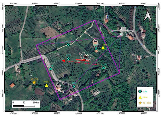
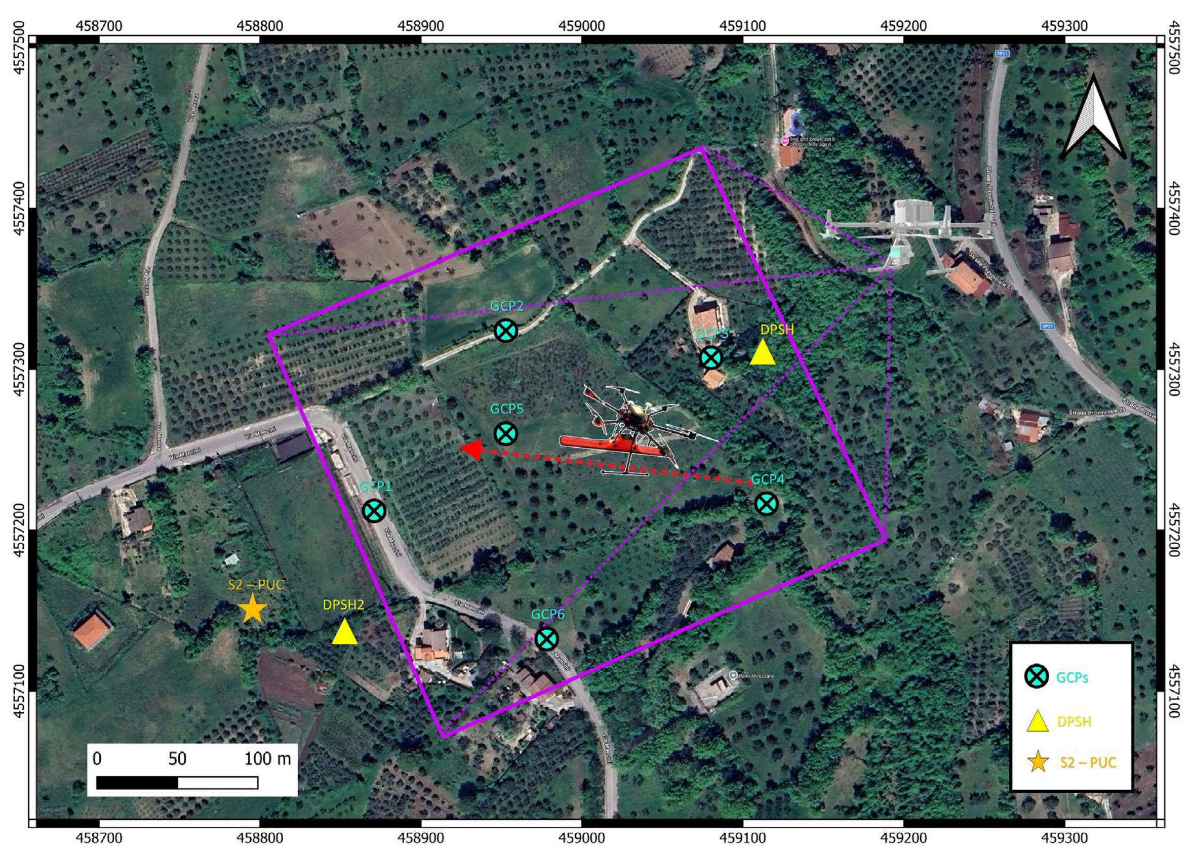
The overall survey configuration and acquisition geometry are schematically illustrated in Figure 2.
Figure 2.
Schematic representation of the integrated UAV survey at the Melizzano site. The layout shows the UAV-LiDAR coverage of the slope and the UAV-GPR transect used for subsurface imaging. Ground Control Points (GCPs) used for georeferencing are indicated by light blue circles. The location of borehole S2 (PUC) is marked with an orange star, while DPSH investigation points (DPSH 1 and DPSH 2) are represented by yellow triangles.
2.1. UAV-Borne Ground Penetrating Radar System
The Melizzano unstable slope was investigated using a UAV-borne low-frequency GPR system. The radar payload was a Cobra Plug-in Sub-Echo 70 antenna (20–140 MHz) mounted beneath a DJI Matrice 600 Pro UAV (https://www.dji.com/it) using a non-conductive support to minimize interference from the drone electronics.
The antenna was oriented parallel to the flight path to optimize detection of low-inclined and sub-horizontal reflectors associated with stratigraphic interfaces and potential sliding surfaces. To ensure effective electromagnetic coupling with the terrain, the UAV was flown at the lowest possible altitude of ~1 m above ground, compensating for a dense pasture grass (~60–70 cm high) [35].
Radar traces were continuously recorded along the transect, with a nominal flight speed of ~1 m/s (Figure 2). Accurate georeferencing was achieved using a high-precision GNSS receiver operating in RTK mode, with corrections delivered via NTRIP from the INGV RING network (PSB1 station, Pesco Sannita) [11,24]. A radar altimeter and synchronized data acquisition unit maintained a constant antenna height and allowed precise spatial positioning of radar traces, enabling reliable imaging of the subsurface.
2.2. Survey Design and Flight Configuration
Building on the system configuration described in Section 2.1, the UAV-GPR survey was designed to capture the main subsurface features of the Melizzano site through an east–west oriented transect coinciding with the axis of the unstable slope defined in Figure 1. The selection of this transect was based on preliminary geomorphological observations, including slope breaks, minor scarps, and depressions identified in the field, and on the analysis of available digital topography from Carta Tecnica Regionale, ensuring that the radar profile intercepted the key features of the main gravity-driven slope instability. This targeted approach maximizes the probability of detecting the main sliding surface and significant stratigraphic features, across an area previously identified as experiencing a quiescent complex landslide (Figure 1).
The UAV was flown at an altitude of approximately 1 m above the ground. Maintaining a low flight altitude is critical in UAV-borne GPR surveys, as signal strength and resolution decrease with increasing antenna–ground distance [36,37]. The lowest possible altitude ensured effective electromagnetic coupling, enhancing the detectability of shallow subsurface reflectors associated with gravity-driven deformations and local stratigraphy.
The UAV followed a terrain-adaptive flight path, with altitude continuously adjusted by the integrated GNSS receiver and radar altimeter. This terrain-following configuration allowed the antenna to maintain a nearly constant height above the ground, compensating for local variations in slope and micro-topography. Maintaining a consistent distance between the antenna and the ground is crucial to minimize signal distortions and variations in reflection amplitude, as these could otherwise undermine the accuracy of radar interpretation.
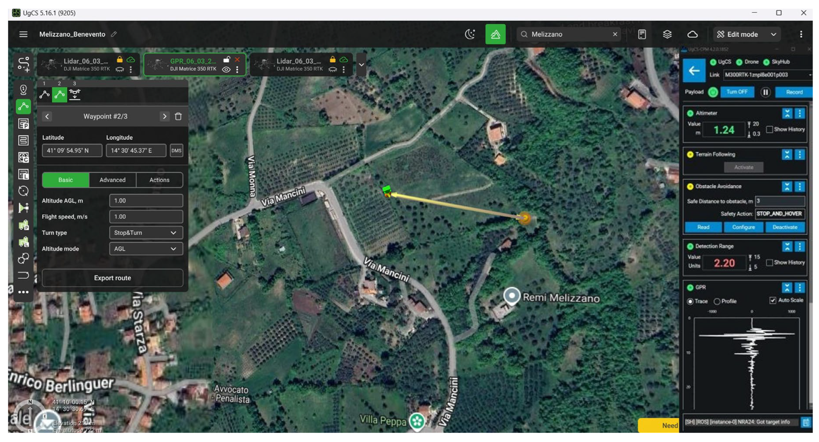
The flight mission was planned and carried out using UgCS Enterprise v5.16.1 software with the Custom Payload (CP) module (https://www.sphengineering.com/flight-planning/ugcs/downloads) (Figure 3).
Figure 3.
UAV-GPR survey flight plan, with left panel showing main flight parameters and right panel the Custom Payload (CP) module for synchronized radar acquisition.
This setting enabled full integration of the radar payload with UAV navigation and real-time monitoring through the SkyHub onboard computer. The CP module allowed synchronization between radar acquisition and UAV positioning, ensuring that each radar trace was precisely georeferenced along the track. Additionally, the terrain-following functionality of UgCS dynamically adjusted the UAV altitude based on real-time topographic data, further improving the uniformity and quality of the radar profile.
Radar data were recorded continuously along the transect at a nominal flight speed of ~1 m/s, providing high-density spatial coverage suitable for detecting subtle subsurface structures. The combination of low-altitude flight, terrain-following, and synchronized acquisition ensured that the resulting radargram accurately represents both the depth and geometry of the landslide body, supporting reliable interpretation of the main sliding surface and internal stratigraphic features.
2.3. UAV-Based LiDAR Survey
To enhance the subsurface imaging provided by UAV-GPR and enable detailed characterization of surface morphology, a UAV-based LiDAR survey was conducted over the Melizzano site. The survey employed a DJI Matrice 350 RTK platform equipped with a DJI Zenmuse L2 LiDAR sensor, integrating a laser scanner, high-precision inertial measurement unit (IMU), and RTK-enabled GNSS positioning. This configuration allowed direct georeferencing of each laser return and ensured centimeter-level positional accuracy across the study area.
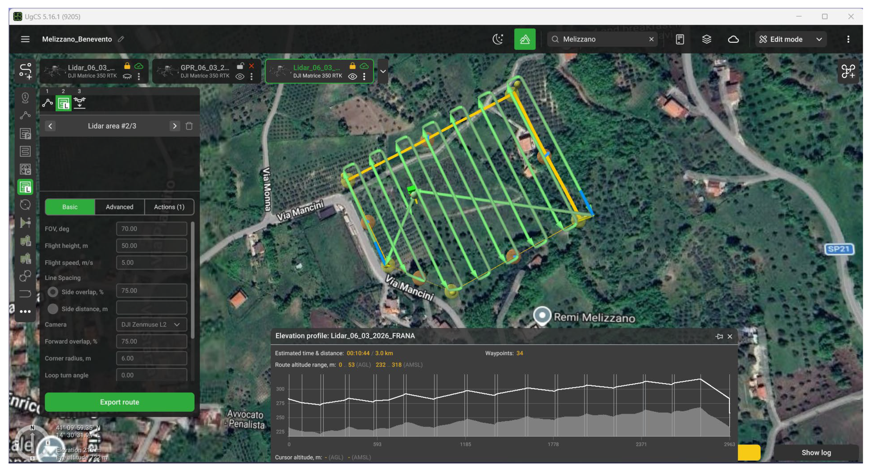
The LiDAR acquisition was performed along a series of parallel flight lines covering the whole site. Flight planning was executed in UgCS Enterprise v5.16.1 (SPH Engineering), defining flight altitude (~50 m above ground level), line spacing, sidelap and forward overlap (~75%), and flight speed (~5 m/s) to ensure homogeneous point cloud coverage. The UAV navigation system operated in RTK mode with differential corrections delivered via NTRIP from the INGV RING GNSS network (PSB1 station, Pesco Sannita (BN)), providing a high-accuracy reference frame for the LiDAR-derived point cloud [38,39]. Six Ground Control Points (GCPs) were also measured in RTK mode using the same PSB1 reference station. These points were used to validate and refine the absolute positioning of the LiDAR-derived point cloud, reducing residual georeferencing errors and improving the overall accuracy of the Digital Terrain Model. The overall flight plan is shown in Figure 4.
Figure 4.
UAV-LiDAR survey flight plan, showing parallel flight lines ensuring full coverage of the slope and uniform point cloud density.
A key feature of the Zenmuse L2 sensor is its ability to record multiple returns (up to five) from a single laser pulse. When the pulse encounters vegetation, part of the energy is reflected by the canopy, while the remainder continues to lower layers and finally the ground. These multiple returns enable reliable detection of ground points beneath vegetation, which is critical in areas with dense grass cover, such as the study area [40].
The raw LiDAR-derived point cloud was processed using DJI Terra software (https://enterprise.dji.com/it/dji-terra) [41,42]. The UAV trajectory reconstructed from RTK GNSS and IMU data was combined with laser ranging measurements to generate a georeferenced 3D point cloud. The GCPs were used as independent control points to assess and, where necessary, refine the absolute accuracy of the point cloud during processing. The resulting absolute vertical accuracy of the LiDAR dataset is estimated to be within ±2–3 cm (RMSE), consistent with RTK-based UAV-LiDAR surveys conducted under similar conditions. Ground points were classified from non-ground returns using slope thresholds, local elevation differences, and iterative surface fitting, and then interpolated to produce a high-resolution Digital Terrain Model (DTM) representing the bare-earth topography of the unstable area. The resulting DTM provides a detailed representation of the slope morphology, revealing subtle features, only slightly detectable on the field due to the persistent dense vegetation cover, such as minor scarps, slope breaks, and depressions possibly associated with gravity-driven movements [43]. This high-resolution topographic data also served as the reference surface for georeferencing and topographic correction of the UAV-GPR dataset, ensuring accurate spatial integration between surface morphology and subsurface structure.
The main technical parameters of both UAV-GPR and UAV-LiDAR surveys are summarized in Table 1, providing an overview of platforms, sensors, flight configurations, and positioning systems.
Table 1.
Main technical parameters of the UAV-GPR and UAV-LiDAR surveys conducted over the Melizzano slope.
This LiDAR-derived topography represents a fundamental component of the integrated workflow, as it directly supports the geometric correction and interpretation of the UAV-GPR data described in the following sections.
2.4. LiDAR Data Processing and Digital Terrain Model Generation
The raw LiDAR point cloud acquired from the UAV survey was processed to generate a high-resolution DTM representing the bare-earth topography of the Melizzano landslide site [44,45,46,47]. The processing workflow began with reconstruction of the UAV trajectory using RTK GNSS and IMU data, providing accurate positioning and orientation of the LiDAR sensor during acquisition. Laser ranging measurements were then combined with the reconstructed trajectory to produce a georeferenced three-dimensional point cloud [48,49,50,51,52,53].
Each point in the cloud represents a surface location where the emitted laser pulse was backscattered. Thanks to the capability of the Zenmuse L2 sensor to record multiple returns (up to five per pulse), the dataset contains information not only from the vegetation canopy but also from intermediate layers and the ground surface [40,54]. This feature significantly improves ground point detection in densely vegetated environments, such as the Melizzano landslide, where pasture grasses and other herbaceous vegetation reach heights of approximately 60–70 cm.
Ground classification was performed using DJI Terra software, employing slope thresholds, local elevation variations, and iterative surface fitting to distinguish ground returns from vegetation and other non-ground points [55]. Only classified ground points were retained for interpolation to generate the DTM. The resulting model provides a high-resolution representation of the ground morphology, with a spatial resolution sufficient to detect minor scarps, slope breaks, and subtle depressions related to gravitational deformation [56,57].
The novel DTM also served as the topographic reference for georeferencing and topographic correction of UAV-GPR data. By integrating the LiDAR-derived surface with the radar profile, spatial inconsistencies due to variable UAV altitude and terrain irregularities were minimized, ensuring precise alignment between surface and subsurface datasets [58,59,60]. This integration allows simultaneous analysis of morphological features and subsurface structure, supporting accurate interpretation of the gravity-driven instabilities’ geometry and internal kinematics [34]. The resulting DTM is therefore not only a geomorphological product but also a key input for the subsequent processing of the UAV-GPR dataset.
2.5. GPR Data Processing
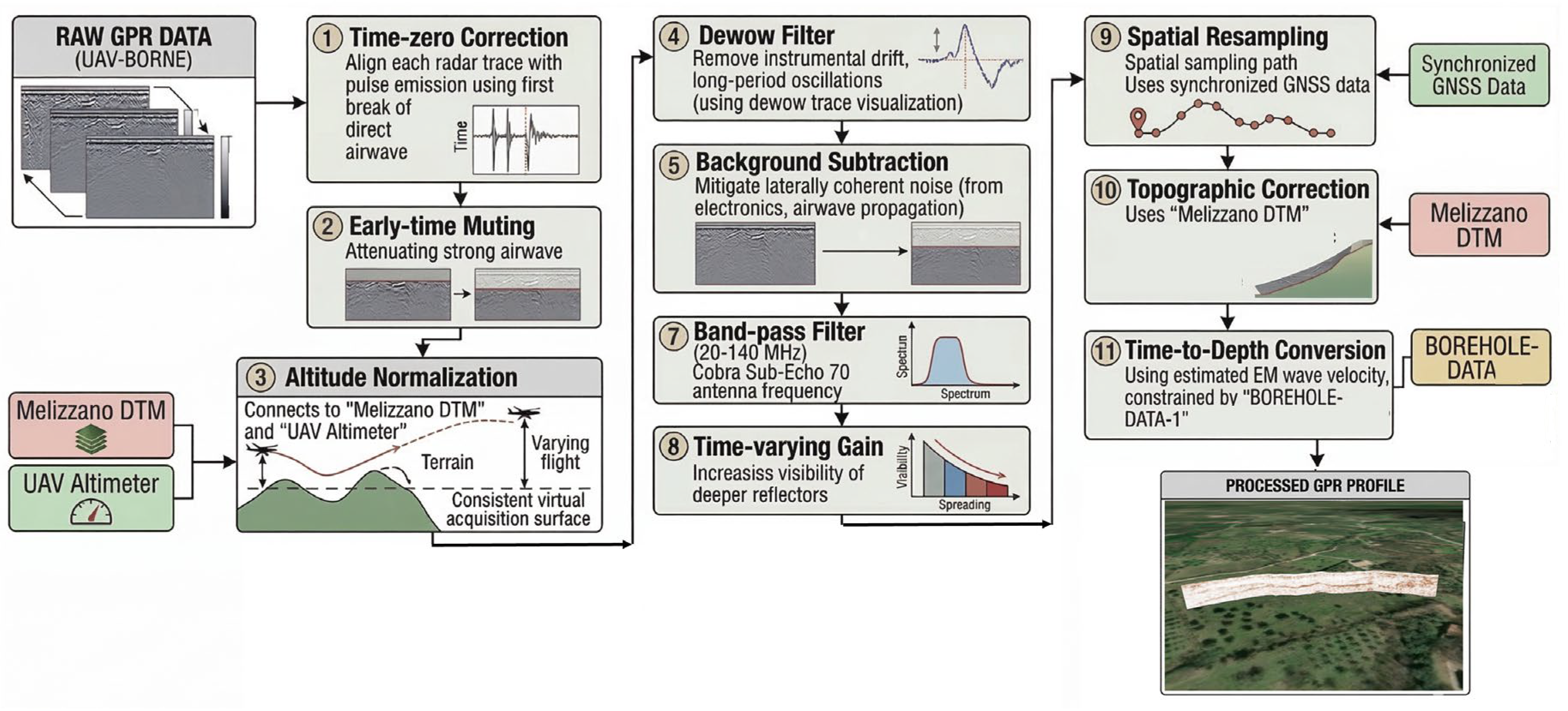
The radar data acquired during the UAV survey were processed to produce a coherent subsurface profile useful to support the geological interpretation. Airborne GPR acquisition presents specific challenges compared to conventional ground-based surveys, including variations in the antenna-to-ground distance, UAV motion, and strong direct airwave components [35,61]. To address these issues, a multi-step processing workflow was applied, as schematically illustrated in Figure 5.
Figure 5.
Processing workflow applied to the UAV-borne GPR dataset. The sequence includes corrections specifically required for airborne acquisition, such as altitude normalization using radar altimeter data and topographic correction based on the LiDAR-derived Digital Terrain Model (DTM).
At first, a time-zero correction was performed to align each radar trace with the emission of the electromagnetic pulse, using the first break of the direct airwave [11,62,63]. This ensured consistent temporal referencing along the profile. The early-time muting procedure was then applied to attenuate the strong airwave typical of airborne GPR, improving the visibility of shallow subsurface reflections [64]. Variations in antenna height due to terrain irregularities or UAV dynamics were corrected through altitude normalization, which combined radar altimeter data with the LiDAR-derived DTM [65]. This step allowed all traces to be referenced to a consistent virtual acquisition surface, reducing geometric distortions in the radargram.
Instrumental drift and long-period oscillations were removed using a dewow filter, while laterally coherent noise from system electronics and airwave propagation was mitigated through background subtraction [66,67]. Trace stacking was then employed to reduce random noise and enhance the signal-to-noise ratio [68]. The radar signal was filtered using a band-pass filter tuned to the effective frequency range of the Cobra Sub-Echo 70 antenna (20–140 MHz), suppressing frequency components not associated with meaningful subsurface reflections. A time-varying gain function was applied to compensate for geometrical spreading and material attenuation, increasing the visibility of deeper reflectors [24,69].
To ensure uniform spatial sampling, radar traces were resampled along the UAV trajectory using synchronized GNSS data, improving the geometric consistency of the radar section [24,70]. Topographic correction was then performed using the LiDAR-derived DTM, referencing the radargram to the actual terrain surface. This correction is critical in sloping environments like the Melizzano site, where variable topography could otherwise distort the depth positioning of subsurface features [71,72]. Finally, the two-way travel times of the radar waves were converted to depth using an estimated electromagnetic wave velocity of 0.08–0.10 m/ns, constrained by borehole data and local lithology [73].
The resulting radargram provides a detailed image of the whole unstable slope, revealing coherent subsurface reflectors and internal heterogeneities. Integration with the high-resolution LiDAR DTM ensures accurate georeferencing and allows direct comparison with borehole stratigraphy, enhancing the reliability of the interpretation of the main sliding surface and associated deformation patterns. Uncertainties in depth estimation are mainly related to the assumed electromagnetic wave velocity, which may vary depending on lithology and moisture content. However, calibration with borehole data reduces this uncertainty.
2.6. Borehole Data and Validation Strategy
To support the interpretation of the UAV-borne GPR data and validate the geophysical results, available borehole stratigraphic logs from geotechnical investigations in the study area were integrated into the analysis [74,75]. These surveys, performed as part of local slope stability studies and municipal urban planning (municipal urban planning, PUC), provide direct information on the lithological succession, thickness of shallow deposits, and depth of more consolidated materials, representing an essential reference for calibrating the radar interpretation.
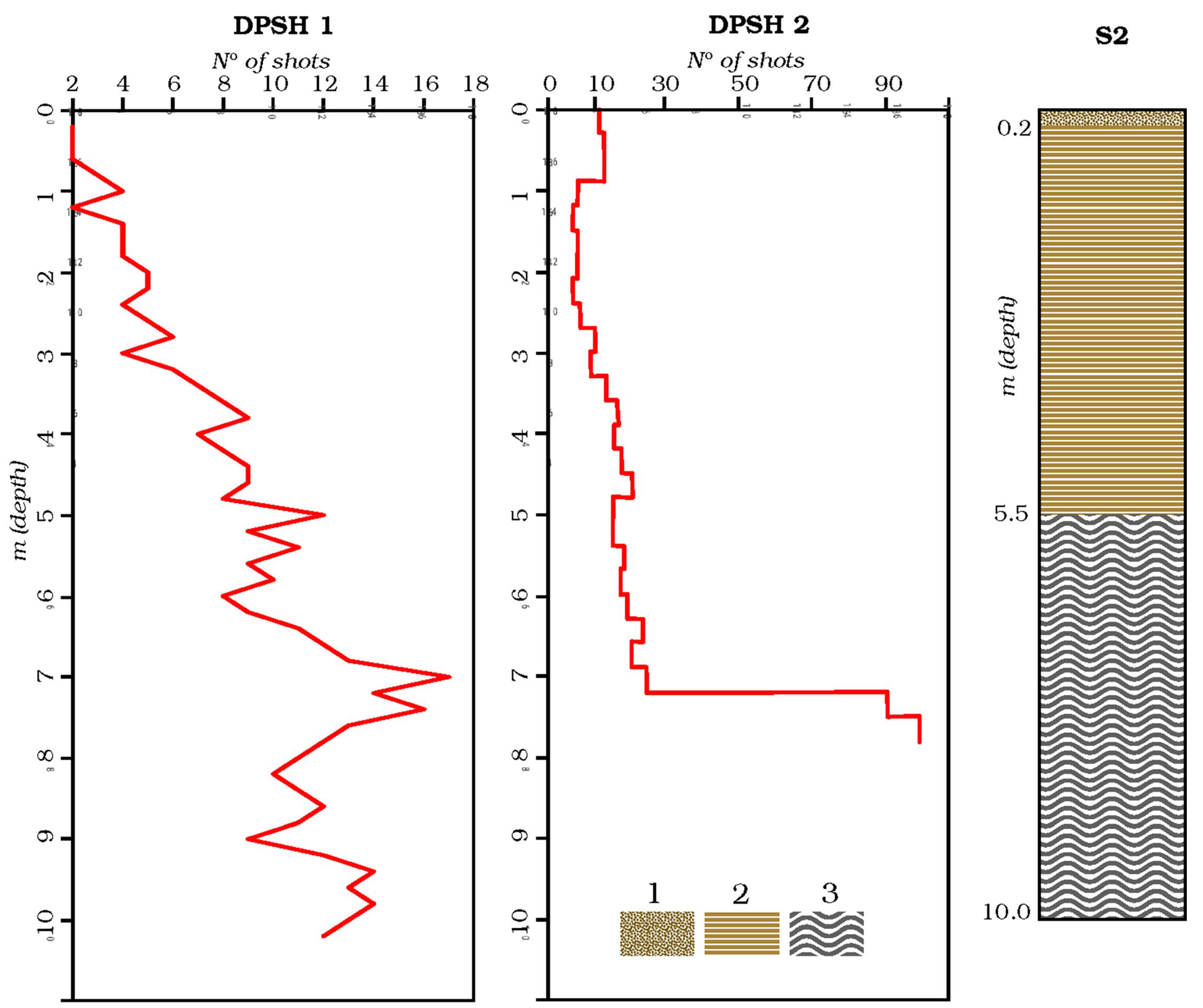
Specifically, borehole drilling for geognostic purposes (continuous core recovery) and Dynamic Probing Super Heavy (DPSH) tests were considered. The nearest boreholes (locations shown in Figure 2) were accurately georeferenced and correlated to the UAV-GPR survey transect, allowing direct spatial comparison between observed stratigraphic interfaces and radar reflectors [76]. Particular attention was given to identifying correspondences between lithological boundaries in the boreholes and prominent reflectors in the processed radargram, aiming to constrain the depth and geometry of the main sliding surface [77]. The most representative borehole log data are summarized in Figure 6.
Figure 6.
DPSH and borehole reference stratigraphy. Location of DPSH 1, DPSH 2 and S2 is reported in Figure 2. Lithological legend for S2 borehole stratigraphy from top to bottom: (1) vegetal soil; (2) silty sands, clayey deposits and marls; (3) over-compacted gray-blue clays (stratigraphic data and DPSH reports are derived from “Piano Urbanistico Comunale” and direct survey by G.T.).
DPSH 1 was performed in the buildup area just N-NE of the study area (Figure 1 and Figure 2, drilling through an undisturbed stratigraphic setting as near as the area affected by field evidence of instability: ~0.5 m of vegetal soil, ~6 m of a medium compatible with clayey and marly deposits, and, down to 10 m, very hard over-compacted clays. DPSH 2, located at the W-SW bounds of the slope, showed a similar behavior, with a strong increase in hardness around 7 m depth. The S2 borehole provides the reference stratigraphy, showing the superposition of units compatible with DPSH results: ~0.2 m of vegetal soil, followed by 5 m of yellow-brownish silty sands, clayey deposits, and marls, and gray-blue clays up to 10 m, over-compacted in the deepest layers. This last unit represents the local, undisturbed substratum. As shown in Figure 6, DPSH data indicate a strong increase in the number of shots at greater depth relative to the main lithological contact between units 2 and 3. This apparent discrepancy likely reflects a gradual transition from “relaxed” gray-blue clays to their over-compacted lower portion.
Figure 6 should be regarded as a schematic synthesis of these pre-existing investigations, where the DPSH penetration trend is broadly consistent with the three main lithological units of the S2 log. The apparent mismatch at greater depth is therefore interpreted as the expression of a progressive over-compaction within the clayey substratum, rather than as a sharp lithological boundary.
Comparison between geophysical and borehole data revealed strong agreement, particularly in the depth interval separating heterogeneous shallow deposits from the underlying stable substrate. This correspondence supports the interpretation of the laterally continuous high-amplitude reflector at ~10 m depth as a key sliding surface. Borehole information also guided the selection of electromagnetic wave velocity for time-to-depth conversion, ensuring accurate depth positioning of subsurface features in the radar profile [78].
Overall, this validation strategy underscores the complementary nature of geophysical and borehole data. UAV-GPR provides spatially continuous subsurface imaging, while boreholes supply essential ground-truth information, increasing the reliability of geological interpretations and enabling robust identification of the sliding surface and internal heterogeneities within the unstable geological body [32]. The depth of the interpreted sliding surface differs from borehole constraints by less than 1–2 m along the profile, confirming the reliability of the GPR-based interpretation. The application of the above-described integrated methodology provided both high-resolution surface data and detailed subsurface imaging, whose results are presented in the following section.
3. Results
3.1. Surface Morphology Derived from LiDAR Data
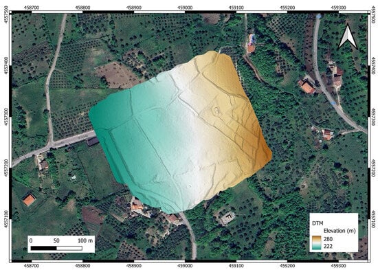
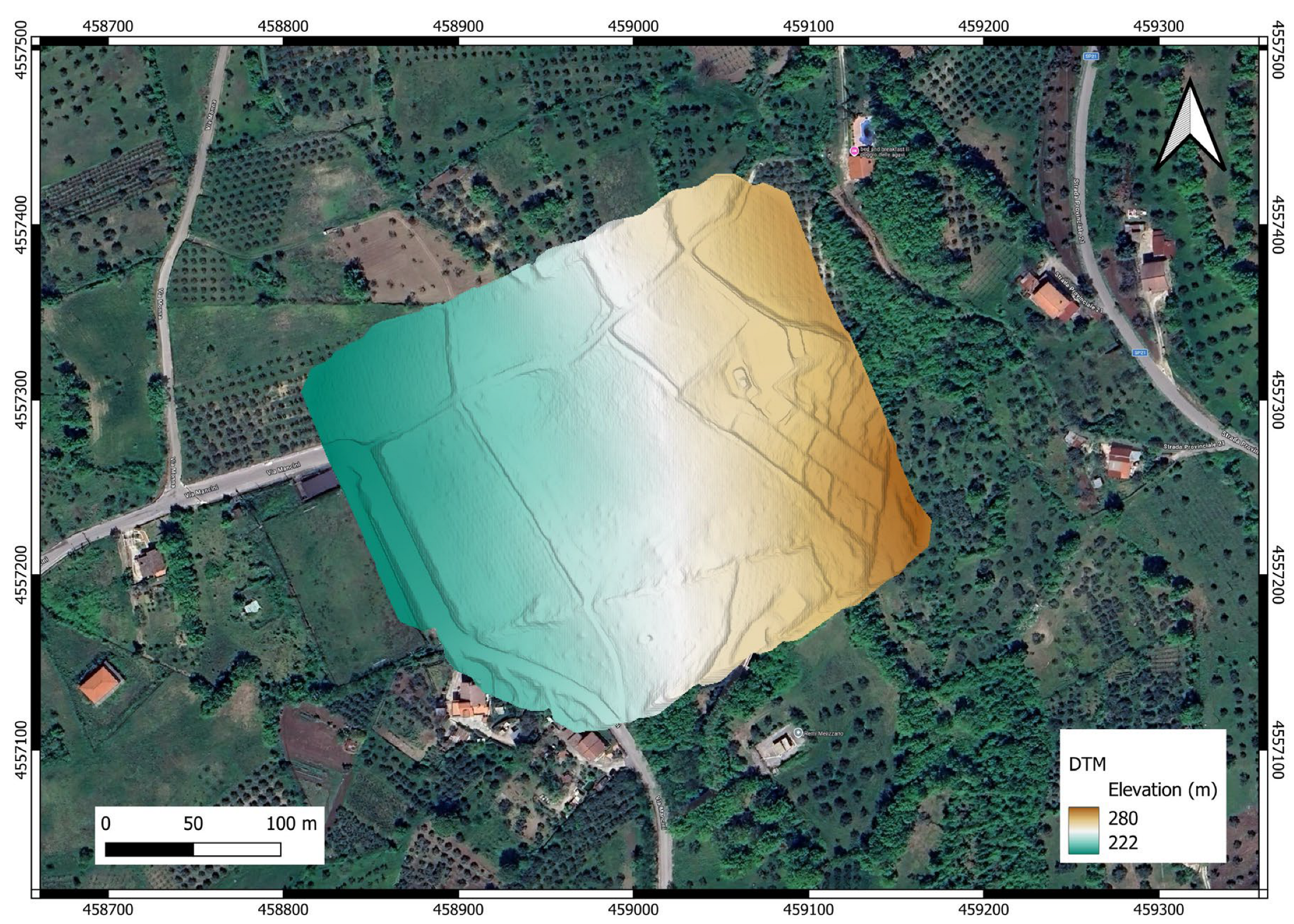
The high-resolution DTM obtained from the UAV-LiDAR survey provides a detailed representation of the surface morphology of the Melizzano site (Figure 7).
Figure 7.
High-resolution DTM from UAV-LiDAR data, showing detailed slope morphology and enabling identification of subtle topographic features.
The LiDAR survey generated a dense three-dimensional point cloud with an average density of approximately 2400 points/m2. After ground classification, ground returns were extracted to produce a DTM with a grid resolution of 1.49 cm/px, enabling detailed representation of small-scale geomorphological features. The integration of RTK positioning with GCP constraints ensured centimetric absolute accuracy of the terrain model. Within the investigated area, slope angles derived from the LiDAR DTM range from approximately 0° to 57°, with an average value of about 11°.
The terrain model reveals subtle geomorphological elements associated with evidence of gravitational deformation that are not completely identifiable in the field due to dense vegetation. In the upper portion of the slope, the DTM highlights a slightly concave morphology characterized by minor scarps and slope discontinuities, which likely correspond to the source area of an active gravity-driven body, identifiable as a minor, shallow-seated compound landslide [79]. Downslope, the terrain smooths and becomes more uniform, reflecting the transport zone where displaced materials have undergone partial reorganization during translation. In addition, frequent agricultural activities constantly remove material from the landslide pile, smoothing the morphologies and making the delineation of the phenomenon problematic. The high spatial resolution of the DTM also allowed precise georeferencing of the UAV-GPR acquisition line, facilitating the integration of surface and subsurface datasets and supporting the interpretation of both morphological and structural features.
3.2. Subsurface Structure Revealed by UAV-GPR
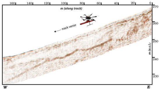
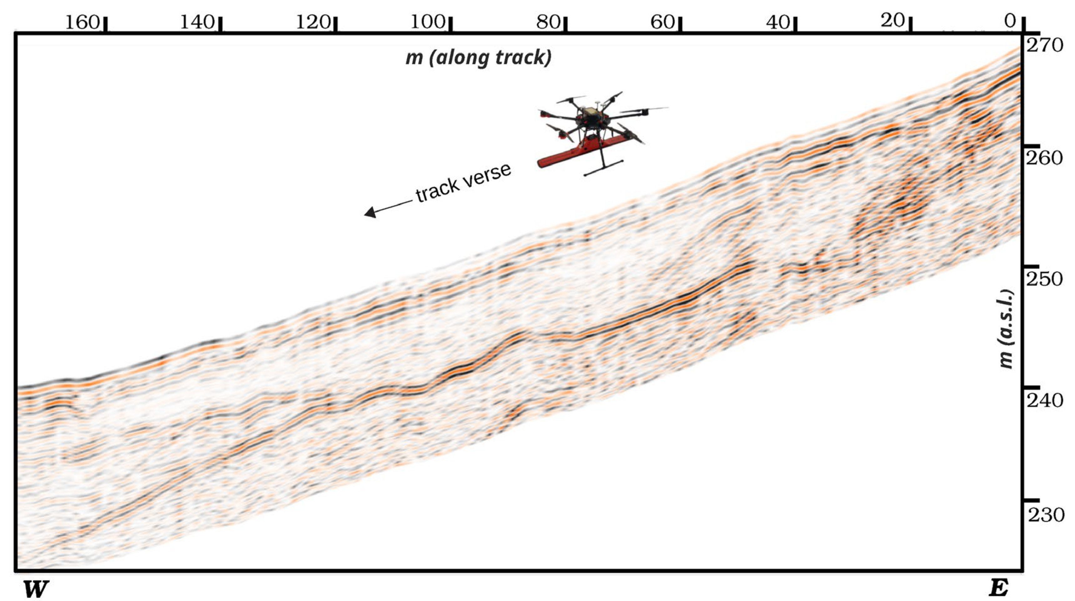
The UAV-GPR survey produced a coherent radargram along the east–west transect crossing the main recognized landslide, reaching depths of approximately 15 m (Figure 8).
Figure 8.
UAV-GPR radargram along the east–west transect, showing subsurface reflections down to ~15 m after processing and time-to-depth conversion.
Signal penetration is effective down to ~12 m, below which the signal-to-noise ratio progressively decreases. The depth scale was obtained through time-to-depth conversion using the estimated electromagnetic wave velocity described in Section 2.5.
The most prominent feature observed is a laterally continuous high-amplitude reflector at an average depth of ~10 m, interpreted as a key sliding surface. Above this interface, chaotic and heterogeneous reflections correspond to destructured units forming the landslide body, indicating strong internal deformation associated with gravitational displacement. In several areas, sub-parallel reflectors with moderate lateral continuity likely represent partially preserved stratified blocks incorporated into the displaced mass. Below the interpreted sliding surface, the radar signal becomes more homogeneous and attenuated, suggesting relatively undisturbed geological units that form the relatively stable geological substrate.
3.3. Radar Interpretation and Correlation with Borehole Data
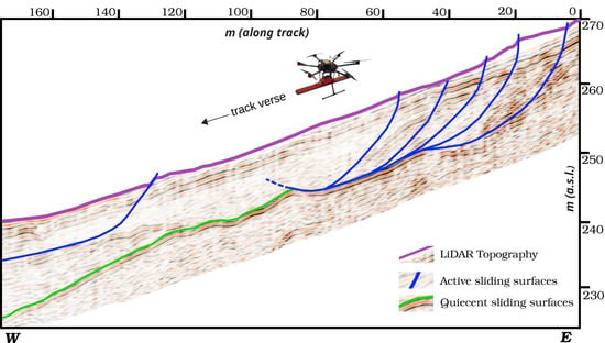
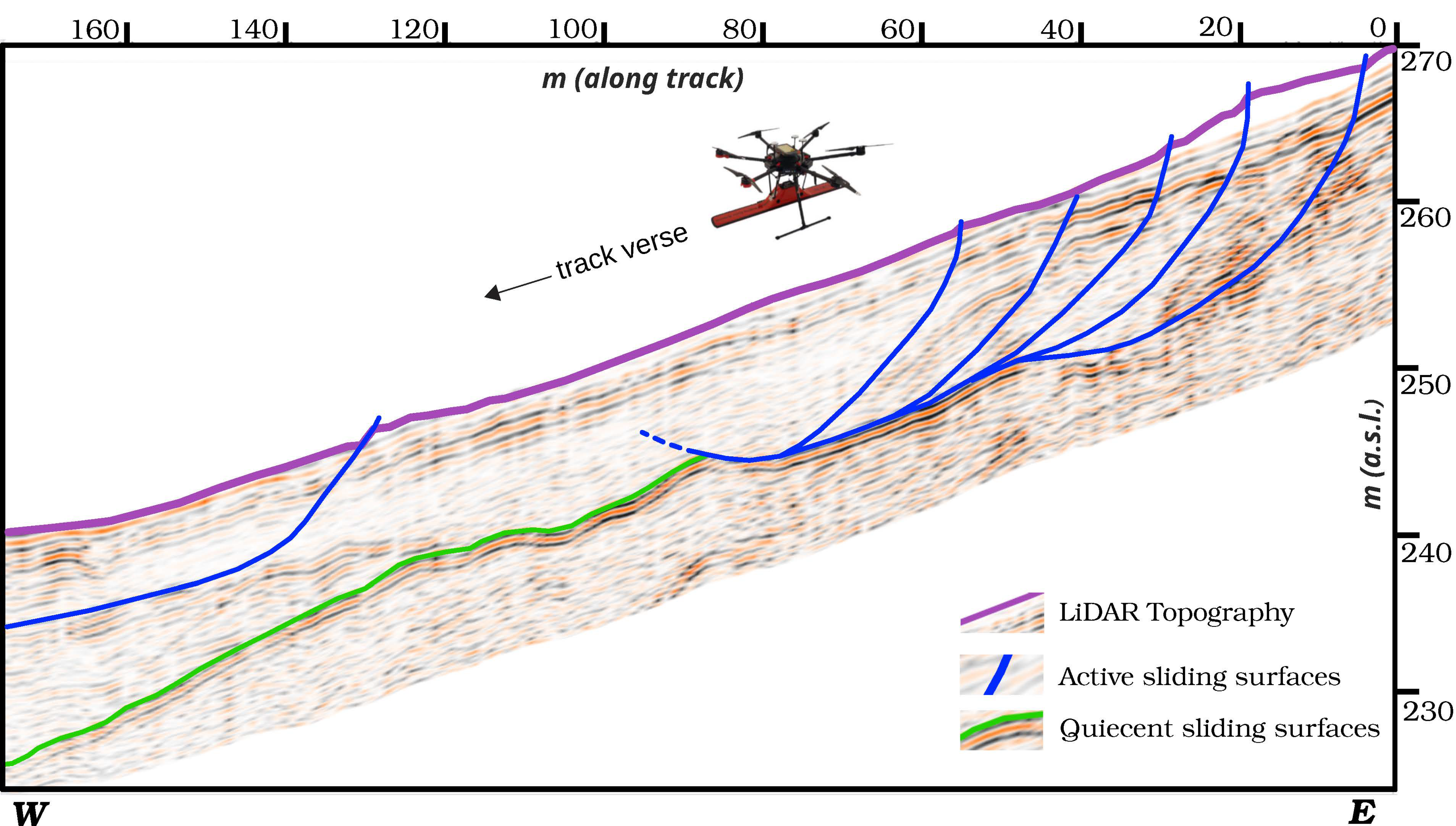
To refine the interpretation of the radargram and validate the identified subsurface features, the UAV-GPR data were integrated with borehole information. The interpreted radargram is shown in Figure 9.
Figure 9.
Interpreted UAV-GPR radargram along the Melizzano main landslide transect. Main retrieved sliding surfaces are highlighted confirming the depth and extent of the detachment surfaces.
Analysis of GPR reflections allowed distinction of multiple subsurface features. The upper portion of the radargram exhibits chaotic reflections typical of disturbed heterogeneous landslide deposits. Sub-parallel reflectors in the central portion indicate partially preserved stratigraphy within the displaced material, supporting the interpretation of the landslide as an earth slide involving heterogeneous sedimentary deposits.
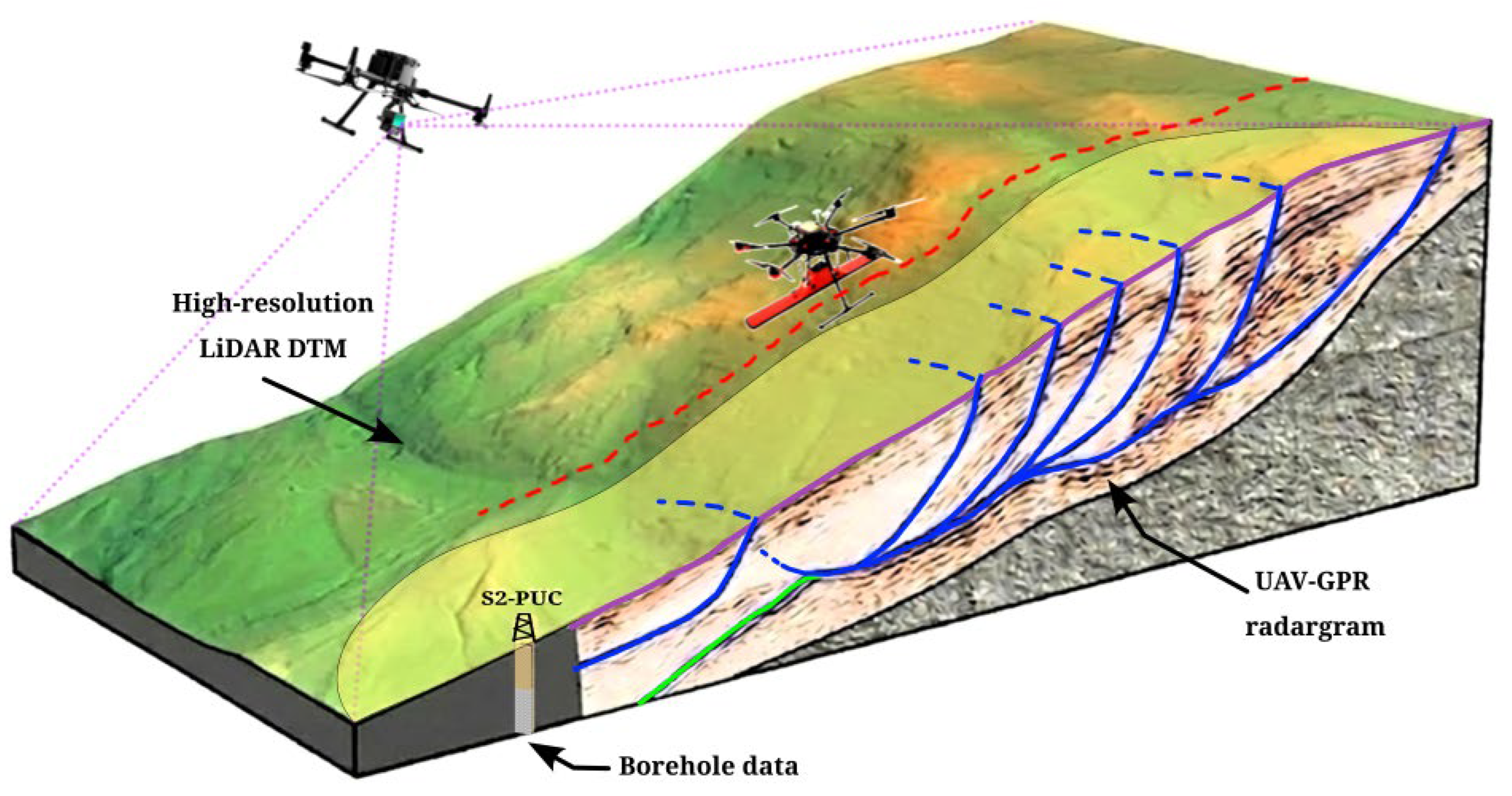
The laterally continuous high-amplitude reflector at ~10 m depth extends across the radar profile and shows a smooth geometry with minor variations along the slope, interpreted as the main sliding surface separating displaced materials from the underlying stable substrate. This surface in its deepest, western portion, does not show evidence of activity and can be considered a quiescent sliding surface (green line of Figure 9). Conversely, in the eastern and shallow portion of the radargram the 10 m reflector shows an imbricate geometry, with branches reaching the surface in correspondence with topographic steps (blue lines of Figure 9). This geometry is consistent with the mapped topographic steps and scarps along the slope, and supports a close correspondence between the shallow branches of the sliding surface and the observed breaks in slope. Stratigraphic evidence of dislocations confirms the state of activity of these shallow branches. Borehole logs corroborate this interpretation, indicating a transition from shallow heterogeneous deposits composed of silty–sandy materials with calcareous gravel and breccia blocks to more compact geological units at comparable depths. The correlation with borehole data also constrained the electromagnetic wave velocity used in time-to-depth conversion, ensuring reliable depth estimation.
4. Discussion
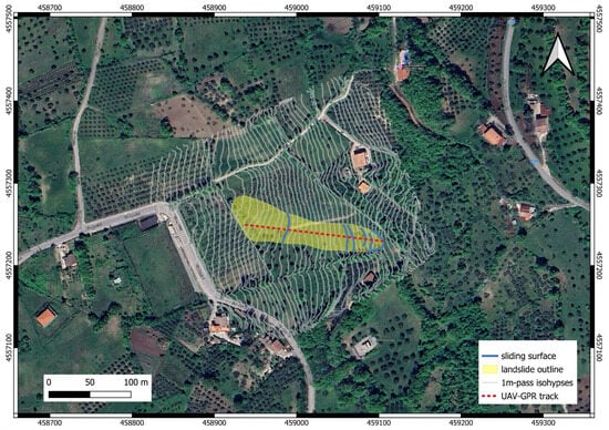
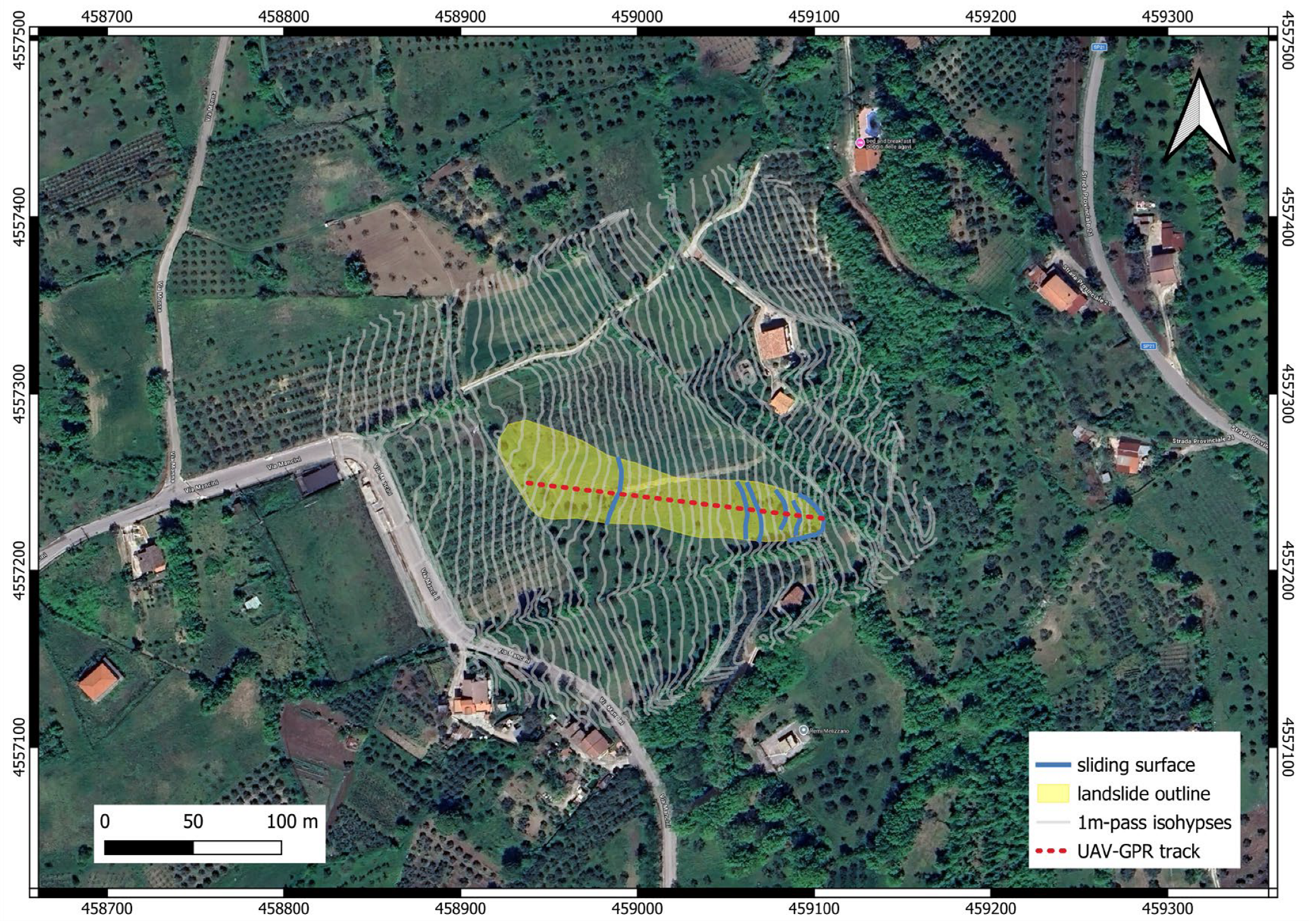
The integrated UAV-GPR and UAV-LiDAR analysis provides new insights into both the surface morphology and subsurface architecture of the investigated landslide, enabling a more comprehensive interpretation of its geometry, kinematics and its state of activity. Figure 10 summarizes the geomorphological interpretation derived from LiDAR data, where the original topography is represented through 1 m interval isolines, allowing the identification of landslide-related topographic features.
The presence of concave-to-convex geometries drove the identification of source-to-transport zones across the unstable slope, allowing the outline of the main landslide active in the study area (yellow-shadowed area of Figure 10). The westernmost portion of the pile appears truncated along a NNW-SSE lineament, coinciding with a country road frequently reworked by farmers to recover damages caused by the seasonal translation of the landslide pile.
The high-resolution DTM generated from LiDAR enabled precise topographic correction of the radar data and enhanced spatial interpretation of both surface morphology and internal subsurface structures. Furthermore, it revealed subtle geomorphological features, such as minor scarps, slope breaks, and depressions, which are often obscured in field surveys due to dense vegetation. These surface indicators, when combined with UAV-GPR data, provided essential support for understanding the distribution and geometry of displaced units. This morphological framework provides the basis for interpreting the subsurface structures imaged by UAV-GPR.
To better illustrate the spatial relationship between surface morphology and subsurface structures, a 3D integrated model combining UAV-LiDAR and UAV-GPR data is presented in Figure 11.
From a subsurface perspective, the UAV-GPR data confirm a clear contrast between highly disturbed landslide deposits and the underlying undisturbed substrate, supporting the interpretation of a well-defined internal structure within the landslide body.
The identified reflector at ~10 m depth is interpreted as the main sliding surface, as supported by borehole correlation (Figure 9), confirming its regional variability and role in controlling landslide activity.
These findings are consistent with previous studies highlighting the effectiveness of GPR in detecting subsurface discontinuities associated with landslide processes [7,80,81]. However, most of these applications rely on ground-based surveys, which are often limited by terrain accessibility and vegetation cover. Compared to previous UAV-based applications, this study demonstrates improved investigation depth (up to ~15 m) and the capability to detect deep-seated sliding surfaces in vegetated environments.
This interpretation is supported by the concave-upward geometry of the sliding surface in the upper sector (rotational component) and its transition to a sub-planar geometry downslope (translational component) (Figure 9). This process exhibits a strong topographic signature clearly recognized by LiDAR survey. The integration of LiDAR-derived topography with GPR data allows visualization of the main failure surface geometry in three dimensions.
Beyond geological interpretation, the results also highlight key methodological aspects of the integrated approach. From this perspective, the combined UAV-GPR and UAV-LiDAR approach proved highly effective. UAV-borne GPR enables low-altitude, non-invasive acquisition of subsurface data in areas where vegetation or terrain steepness would prevent conventional ground-based surveys [82]. Terrain-following flight paths and synchronized radar acquisition ensured that radar traces were consistently georeferenced, reducing distortion and enhancing interpretation reliability. The LiDAR data provided a precise digital representation of the bare-earth surface, improving topographic correction of the radar profile and enabling accurate alignment between surface features and subsurface reflectors. The centimetric accuracy achieved through RTK positioning and GCP validation further strengthens the reliability of the topographic correction applied to the GPR dataset. The multi-return capability of the LiDAR sensor was particularly crucial in dense vegetation, allowing reliable ground point detection beneath herbaceous cover and ensuring a faithful reconstruction of the landslide elements.
Beyond the qualitative and semi-quantitative integration performed here, more advanced strategies based on information theory or wavelet transforms could be applied in future work to numerically integrate UAV-GPR and LiDAR datasets and to optimize the extraction of common structural attributes [83,84]. Such approaches may further enhance the robustness of the combined geophysical interpretation, especially in complex and data-rich environments.
Compared to Electrical Resistivity Tomography (ERT) and seismic methods, UAV-borne GPR enables faster and more flexible data acquisition with high spatial resolution [35,74]. However, its performance may be reduced in conductive or water-saturated materials, due to signal attenuation. In contrast, ERT and seismic techniques generally provide greater investigation depth, albeit at the cost of longer acquisition times and more complex field logistics [85,86].
Despite the promising results, several limitations should be considered. The quality of UAV-borne GPR data is strongly influenced by the stability of the antenna height above ground, which may vary due to UAV dynamics and terrain roughness. Signal attenuation in conductive or water-saturated materials may further reduce penetration depth and limit the detectability of deeper features. In addition, the interpretation of radar facies may also remain non-unique in heterogeneous geological contexts and therefore requires integration with ground-truth data such as boreholes. A key limitation of this study is the use of a single UAV-GPR transect, which prevents full three-dimensional reconstruction of the landslide geometry. Future investigations should include multiple parallel profiles to enable true 3D subsurface imaging.
Overall, the results demonstrate that UAV-based geophysical surveys represent a robust tool for investigating slope deformation processes, providing high-resolution datasets for improved landslide characterization and hazard assessment [87].
5. Conclusions
This study demonstrates that low-frequency UAV-borne GPR, when integrated with LiDAR data, can reliably detect deep-seated sliding surfaces in vegetated and inaccessible environments. The UAV-GPR data enabled the identification of a main sliding surface at ~10 m depth, separating landslide deposits from the underlying stable substrate, as confirmed by borehole data.
The geometry of the sliding surface provides clear insight into the landslide state of activity and its kinematics. The results indicate that an active landslide affects the Melizzano slope, part of a wider phenomenon, previously classified as quiescent, and is characterized by a roto-translational mechanism.
This result highlights the capability of low-frequency UAV-borne GPR to resolve deep-seated deformation features even in complex geological settings.
The integration of UAV-GPR and LiDAR data proved essential for linking subsurface structures with high-resolution surface morphology, improving the reliability of landslide characterization. These findings enable inferences about the activity state and kinematics of landslides.
From an applied perspective, the proposed methodology provides a fast, non-invasive, and spatially continuous framework for landslide investigation, particularly in vegetated and inaccessible environments. The approach supports accurate identification of sliding surfaces and interpretation of landslide kinematics.
Future work should focus on the acquisition of multiple parallel UAV-GPR transects to enable a full three-dimensional reconstruction of landslide geometry, as well as on repeated surveys to support temporal monitoring and assessment of slope activity and potential reactivation. Such continued integration of UAV-GPR and LiDAR datasets has strong potential to advance landslide research and improve hazard assessment practices in challenging environments.
Author Contributions
Conceptualization, N.A.F.; methodology, N.A.F.; software, N.A.F.; validation, (all authors); formal analysis, (all authors); data curation, N.A.F. and B.M.; writing—original draft preparation, (all authors); writing—review and editing, (all authors); visualization, N.A.F. and B.M. All authors have read and agreed to the published version of the manuscript.
Funding
These activities are partially funded by “Artificial Intelligence for the automatic interpretation of Ground Penetrating Radar data for subsoil risk assessment and disaster management (AI4Dite)”—CUP D53D23017430001—Grant Assignment Decree No. 1382 adopted on 01-09-2023 by the Italian MUR and “FRA 2024−2025 projects”—Università degli Studi del Sannio (P.I. B. Massa).
Data Availability Statement
The original contributions presented in this study are included in the article. Further inquiries can be directed to the corresponding author.
Acknowledgments
Borehole and Dynamic Probing Super Heavy data have been kindly provided by the municipality of Melizzano (BN). Credit is given to Paola Revellino for the valuable discussions on the subject of landslide characterization.
Conflicts of Interest
The authors declare no conflicts of interest.
References
- Guzzetti, F. Landslide Fatalities and the Evaluation of Landslide Risk in Italy. Eng. Geol. 2000, 58, 89–107. [Google Scholar] [CrossRef] [Scilit]
- Rossi, M.; Guzzetti, F.; Salvati, P.; Donnini, M.; Napolitano, E.; Bianchi, C. A Predictive Model of Societal Landslide Risk in Italy. Earth-Sci. Rev. 2019, 196, 102849. [Google Scholar] [CrossRef] [Scilit]
- Revellino, P.; Guerriero, L.; Grelle, G.; Hungr, O.; Fiorillo, F.; Esposito, L.; Guadagno, F.M. Debris Avalanche, Landslide Initiation, Dynamic Modelling, Southern Italy. IJG 2013, 132, 366–379. [Google Scholar] [CrossRef] [Scilit]
- Salvati, P.; Rossi, M.; Bianchi, C.; Guzzetti, F. Landslide Risk to the Population of Italy and Its Geographical and Temporal Variations. In Extreme Events; American Geophysical Union (AGU): Washington, DC, USA, 2015; pp. 177–194. [Google Scholar]
- Vitale, S.; Ciarcia, S. Tectono-Stratigraphic Setting of the Campania Region (Southern Italy). J. Maps 2018, 14, 9–21. [Google Scholar] [CrossRef] [Scilit]
- Auflič, M.J.; Herrera, G.; Mateos, R.M.; Poyiadji, E.; Quental, L.; Severine, B.; Peternel, T.; Podolszki, L.; Calcaterra, S.; Kociu, A.; et al. Landslide Monitoring Techniques in the Geological Surveys of Europe. Landslides 2023, 20, 951–965. [Google Scholar] [CrossRef] [Scilit]
- Famiglietti, N.A.; Miele, P.; Defilippi, M.; Cantone, A.; Riccardi, P.; Tessari, G.; Vicari, A. Landslide Mapping in Calitri (Southern Italy) Using New Multi-Temporal InSAR Algorithms Based on Permanent and Distributed Scatterers. Remote Sens. 2024, 16, 1610. [Google Scholar] [CrossRef] [Scilit]
- Guzzetti, F.; Carrara, A.; Cardinali, M.; Reichenbach, P. Landslide Hazard Evaluation: A Review of Current Techniques and Their Application in a Multi-Scale Study, Central Italy. Geomorphology 1999, 31, 181–216. [Google Scholar] [CrossRef] [Scilit]
- Jaboyedoff, M.; Oppikofer, T.; Abellán, A.; Derron, M.-H.; Loye, A.; Metzger, R.; Pedrazzini, A. Use of LIDAR in Landslide Investigations: A Review. Nat. Hazards 2012, 61, 5–28. [Google Scholar] [CrossRef] [Scilit]
- Tosti, F.; Slob, E. Determination, by Using GPR, of the Volumetric Water Content in Structures, Substructures, Foundations and Soil. In Civil Engineering Applications of Ground Penetrating Radar; Benedetto, A., Pajewski, L., Eds.; Springer International Publishing: Cham, Switzerland, 2015; pp. 163–194. [Google Scholar]
- Famiglietti, N.A.; Memmolo, G.; Memmolo, A.; Migliazza, R.; Gagliarde, N.; Bucci, D.D.; Cheloni, D.; Vicari, A.; Massa, B. Low-Frequency Ground Penetrating Radar for Active Fault Characterization: Insights from the Southern Apennines (Italy). Remote Sens. 2025, 17, 3631. [Google Scholar] [CrossRef] [Scilit]
- Pueyo Anchuela, Ó.; Frongia, P.; Di Gregorio, F.; Casas Sainz, A.M.; Pocoví Juan, A. Internal Characterization of Embankment Dams Using Ground Penetrating Radar (GPR) and Thermographic Analysis: A Case Study of the Medau Zirimilis Dam (Sardinia, Italy). Eng. Geol. 2018, 237, 129–139. [Google Scholar] [CrossRef] [Scilit]
- Xie, P.; Wen, H.; Xiao, P.; Zhang, Y. Evaluation of Ground-Penetrating Radar (GPR) and Geology Survey for Slope Stability Study in Mantled Karst Region. Environ. Earth Sci. 2018, 77, 122. [Google Scholar] [CrossRef] [Scilit]
- Saadatseresht, M.; Hashempour, A.H.; Hasanlou, M. UAV photogrammetry: A practical solution for challenging mapping projects. Int. Arch. Photogramm. Remote Sens. Spat. Inf. Sci. 2015, 619–623. [Google Scholar] [CrossRef] [Scilit]
- Gennarelli, G.; Catapano, I.; Ludeno, G.; Noviello, C.; Papa, C.; Pica, G.; Soldovieri, F.; Alberti, G. A Low Frequency Airborne GPR System for Wide Area Geophysical Surveys: The Case Study of Morocco Desert. Remote Sens. Environ. 2019, 233, 111409. [Google Scholar] [CrossRef] [Scilit]
- Telling, J.W.; Glennie, C.; Fountain, A.G.; Finnegan, D.C. Analyzing Glacier Surface Motion Using LiDAR Data. Remote Sens. 2017, 9, 283. [Google Scholar] [CrossRef] [Scilit]
- Hung, C.-L.J.; Tseng, C.-W.; Huang, M.-J.; Tseng, C.-M.; Chang, K.-J. Multi-temporal high-resolution landslide monitoring based on UAS photogrammetry and UAS lidar geoinformation. Int. Arch. Photogramm. Remote Sens. Spat. Inf. Sci. 2019, 157–160. [Google Scholar] [CrossRef] [Scilit]
- Honarmand, M.; Shahriari, H. Geological Mapping Using Drone-Based Photogrammetry: An Application for Exploration of Vein-Type Cu Mineralization. Minerals 2021, 11, 585. [Google Scholar] [CrossRef] [Scilit]
- Jaboyedoff, M.; Carrea, D.; Derron, M.-H.; Oppikofer, T.; Penna, I.M.; Rudaz, B. A Review of Methods Used to Estimate Initial Landslide Failure Surface Depths and Volumes. Eng. Geol. 2020, 267, 105478. [Google Scholar] [CrossRef] [Scilit]
- Whiteley, J.S.; Chambers, J.E.; Uhlemann, S.; Wilkinson, P.B.; Kendall, J.M. Geophysical Monitoring of Moisture-Induced Landslides: A Review. Rev. Geophys. 2019, 57, 106–145. [Google Scholar] [CrossRef] [Scilit]
- Šipoš, D.; Gleich, D. A Lightweight and Low-Power UAV-Borne Ground Penetrating Radar Design for Landmine Detection. Sensors 2020, 20, 2234. [Google Scholar] [CrossRef] [Scilit]
- Chen, B.; Maurer, J.; Gong, W. Applications of UAV in Landslide Research: A Review. Landslides 2025, 22, 3029–3048. [Google Scholar] [CrossRef] [Scilit]
- Coccia, S.; Al Heib, M.; Klein, E. Combination of UAV-Borne LiDAR and UAV-Borne Photogrammetry to Assess Slope Stability. In Proceedings of the 7th World Congress on Civil, Structural, and Environmental Engineering (CSEE’22), Virtual Conference, 10–12 April 2022. [Google Scholar]
- Famiglietti, N.A.; Visconti, A.A.; Memmolo, G.; Memmolo, A.; Radaelli, L.; Musmeci, D.; Massa, B.; Amato, V.; Vicari, A.; Santoriello, A. Comparative Assessment of Buried and Exposed Archaeological Remains at Abellinum (Southern Italy) Using Low-Frequency GPR and Photogrammetry. Geosciences 2026, 16, 70. [Google Scholar] [CrossRef] [Scilit]
- Servizio Geologico d’Italia. Note Illustrative Della Carta Geologica d’Italia Alla Scala 1:50,000, F. 431 Caserta Est; Servizio Geologico d’Italia—ISPRA: Rome, Italy, 2010. [Google Scholar] [CrossRef]
- Inventario Frane IFFI|Frana 0620223700. Available online: https://idrogeo.isprambiente.it/app/iffi/f/0620223700?@=41.1624747345617,14.510115863555312,17 (accessed on 23 March 2026).
- Vitale, S.; Ciarcia, S. The Dismembering of the Adria Platforms Following the Late Cretaceous-Eocene Abortive Rift: A Review of the Tectono-Stratigraphic Record in the Southern Apennines. Int. Geol. Rev. 2022, 64, 2866–2889. [Google Scholar] [CrossRef] [Scilit]
- Filocamo, F.; Leone, N.; Rosskopf, C.M.; Scorpio, V.; Giralt, S.; Aucelli, P.P.C. Quaternary Evolution of the Lower Calore and Middle Volturno Valleys (Southern Italy). Water 2021, 13, 741. [Google Scholar] [CrossRef] [Scilit]
- Bufton, J.L.; Garvin, J.B.; Cavanaugh, J.F.; Ramos-Izquierdo, L.A.; Clem, T.D.; Krabill, W.B. Airborne Lidar for Profiling of Surface Topography. Opt. Eng. 1991, 30, 72–78. [Google Scholar] [CrossRef] [Scilit]
- Brubaker, K.M.; Myers, W.L.; Drohan, P.J.; Miller, D.A.; Boyer, E.W. The Use of LiDAR Terrain Data in Characterizing Surface Roughness and Microtopography. Appl. Environ. Soil Sci. 2013, 2013, 891534. [Google Scholar] [CrossRef] [Scilit]
- Borecka, A.; Herzig, J.; Durjasz-Rybacka, M. Ground Penetrating Radar Investigations of Landslides: A Case Study in a Landslide in Radziszów. Stud. Geotech. Mech. 2015, 37, 11–18. [Google Scholar] [CrossRef] [Scilit]
- Hussain, Y.; Schlögel, R.; Innocenti, A.; Hamza, O.; Iannucci, R.; Martino, S.; Havenith, H.-B. Review on the Geophysical and UAV-Based Methods Applied to Landslides. Remote Sens. 2022, 14, 4564. [Google Scholar] [CrossRef] [Scilit]
- Tandon, R.S.; Gupta, V.; Venkateshwarlu, B.; Joshi, P. An Assessment of Dungale Landslide Using Remotely Piloted Aircraft System (RPAS), Ground Penetration Radar (GPR), and Slide & RS2 Softwares. Nat. Hazards 2022, 113, 1017–1042. [Google Scholar] [CrossRef] [Scilit]
- Sestras, P.; Bilașco, Ș.; Roșca, S.; Veres, I.; Ilies, N.; Hysa, A.; Spalević, V.; Cîmpeanu, S.M. Multi-Instrumental Approach to Slope Failure Monitoring in a Landslide Susceptible Newly Built-Up Area: Topo-Geodetic Survey, UAV 3D Modelling and Ground-Penetrating Radar. Remote Sens. 2022, 14, 5822. [Google Scholar] [CrossRef] [Scilit]
- Noviello, C.; Gennarelli, G.; Esposito, G.; Ludeno, G.; Fasano, G.; Capozzoli, L.; Soldovieri, F.; Catapano, I. An Overview on Down-Looking UAV-Based GPR Systems. Remote Sens. 2022, 14, 3245. [Google Scholar] [CrossRef] [Scilit]
- Travassos, X.L.; Avila, S.L.; Adriano, R.L.d.S.; Ida, N. A Review of Ground Penetrating Radar Antenna Design and Optimization. J. Microw. Optoelectron. Electromagn. Appl. 2018, 17, 385–402. [Google Scholar] [CrossRef] [Scilit]
- Swinford, B.; Abubakar, A.; Francke, J.; Dobrovolskiy, A. Challenges and Opportunities with Drone-Mounted GPR. In Proceedings of the First International Meeting for Applied Geoscience & Energy, Denver, CO, USA, 26 September–1 October 2021; pp. 3043–3047. [Google Scholar]
- Famiglietti, N.A.; Cecere, G.; Grasso, C.; Memmolo, A.; Vicari, A. A Test on the Potential of a Low Cost Unmanned Aerial Vehicle RTK/PPK Solution for Precision Positioning. Sensors 2021, 21, 3882. [Google Scholar] [CrossRef] [Scilit] [PubMed]
- Famiglietti, N.A.; Miele, P.; Memmolo, A.; Falco, L.; Castagnozzi, A.; Moschillo, R.; Grasso, C.; Migliazza, R.; Selvaggi, G.; Vicari, A. New Concept of Smart UAS-GCP: A Tool for Precise Positioning in Remote-Sensing Applications. Drones 2024, 8, 123. [Google Scholar] [CrossRef] [Scilit]
- Urban, R.; Štroner, M.; Kovanič, L.; Blišťan, P.; Křemen, T.; Braun, J.; Peťovský, P.; Topitzer, B. Testing the Accuracy and Characteristics of Data Acquired Using DJI Zenmuse L1 and L2 Lidar Systems and Photogrammetric Data Acquired Using DJI Zenmuse P1 in a Quarry Environment. Eur. J. Remote Sens. 2025, 58, 2595361. [Google Scholar] [CrossRef] [Scilit]
- Tamimi, R.; Süleymanoğlu, B.; Elashry, A.; Toth, C. Comparative Assessment of LiDAR Point Clouds Captured Using Inertial Labs RESEPI Gen-I-M2X and DJI Zenmuse L2 Sensors on UAS Platforms for Varying Terrain Conditions. ISPRS Ann. Photogramm. Remote Sens. Spat. Inf. Sci. 2025, X-G-2025, 871–878. [Google Scholar] [CrossRef] [Scilit]
- Tamimi, R.; Toth, C. Accuracy Assessment of UAV LiDAR Compared to Traditional Total Station for Geospatial Data Collection in Land Surveying Contexts. Int. Arch. Photogramm. Remote Sens. Spat. Inf. Sci. 2024, XLVIII-2-2024, 421–426. [Google Scholar] [CrossRef] [Scilit]
- Chen, Z.; Gao, B.; Devereux, B. State-of-the-Art: DTM Generation Using Airborne LIDAR Data. Sensors 2017, 17, 150. [Google Scholar] [CrossRef] [Scilit]
- Rossi, G.; Tanteri, L.; Tofani, V.; Vannocci, P.; Moretti, S.; Casagli, N. Multitemporal UAV Surveys for Landslide Mapping and Characterization. Landslides 2018, 15, 1045–1052. [Google Scholar] [CrossRef] [Scilit]
- Salach, A.; Bakuła, K.; Pilarska, M.; Ostrowski, W.; Górski, K.; Kurczyński, Z. Accuracy Assessment of Point Clouds from LiDAR and Dense Image Matching Acquired Using the UAV Platform for DTM Creation. ISPRS Int. J. Geo-Inf. 2018, 7, 342. [Google Scholar] [CrossRef] [Scilit]
- Bartmiński, P.; Siłuch, M.; Kociuba, W. The Effectiveness of a UAV-Based LiDAR Survey to Develop Digital Terrain Models and Topographic Texture Analyses. Sensors 2023, 23, 6415. [Google Scholar] [CrossRef] [Scilit] [PubMed]
- Silva-Fragoso, A.; Norini, G.; Nappi, R.; Groppelli, G.; Michetti, A.M. Improving the Accuracy of Digital Terrain Models Using Drone-Based LiDAR for the Morpho-Structural Analysis of Active Calderas: The Case of Ischia Island, Italy. Remote Sens. 2024, 16, 1899. [Google Scholar] [CrossRef] [Scilit]
- Gressin, A.; Cannelle, B.; Mallet, C.; Papelard, J.-P. Trajectory-based registration of 3D lidar point clouds acquired with a mobile mapping system. ISPRS Ann. Photogramm. Remote Sens. Spat. Inf. Sci. 2012, 3, 117–122. [Google Scholar] [CrossRef] [Scilit]
- Ilci, V.; Toth, C. High Definition 3D Map Creation Using GNSS/IMU/LiDAR Sensor Integration to Support Autonomous Vehicle Navigation. Sensors 2020, 20, 899. [Google Scholar] [CrossRef] [Scilit]
- Lucks, L.; Klingbeil, L.; Plümer, L.; Dehbi, Y. Improving Trajectory Estimation Using 3D City Models and Kinematic Point Clouds. Trans. GIS 2021, 25, 238–260. [Google Scholar] [CrossRef] [Scilit]
- Liu, H.; Yao, L.; Xu, Z.; Fan, X.; Jiao, X.; Sun, P. A Railway Lidar Point Cloud Reconstruction Based on Target Detection and Trajectory Filtering. Remote Sens. 2022, 14, 4965. [Google Scholar] [CrossRef] [Scilit]
- Chen, J.; Wei, X.; Liang, X.; Xu, H.; Zhou, L.; He, W.; Ma, Y.; Yin, Y. High Precision 3D Reconstruction and Target Location Based on the Fusion of Visual Features and Point Cloud Registration. Measurement 2025, 243, 116455. [Google Scholar] [CrossRef] [Scilit]
- Savio, A.A.D.; Torres, A.L.; Apaza, M.A.C.; Olivera, M.A.V.; Rojas, S.R.L.; Ibarra, G.T.U.; Ñique, J.L.R.; Arevalo, R.I.M. Integrating a LiDAR Sensor in a UAV Platform to Obtain a Georeferenced Point Cloud. Appl. Sci. 2022, 12, 12838. [Google Scholar] [CrossRef] [Scilit]
- Laks, I.; Achtenberg, K. Use of Drone LIDAR Scanning for Volume Estimation of Stockpiles Accumulated in Post-Flotation Sedimentation Ponds—A Case Study of Bukowno (Southern Poland). Inżynieria Min. 2025, 2. [Google Scholar] [CrossRef] [Scilit]
- Fareed, N.; Flores, J.P.; Das, A.K. Analysis of UAS-LiDAR Ground Points Classification in Agricultural Fields Using Traditional Algorithms and PointCNN. Remote Sens. 2023, 15, 483. [Google Scholar] [CrossRef] [Scilit]
- Kasprzak, M.; Jancewicz, K.; Różycka, M.; Kotwicka, W.; Migoń, P. Geomorphology- and Geophysics-Based Recognition of Stages of Deep-Seated Slope Deformation (Sudetes, SW Poland). Eng. Geol. 2019, 260, 105230. [Google Scholar] [CrossRef] [Scilit]
- Conforti, M.; Mercuri, M.; Borrelli, L. Morphological Changes Detection of a Large Earthflow Using Archived Images, LiDAR-Derived DTM, and UAV-Based Remote Sensing. Remote Sens. 2020, 13, 120. [Google Scholar] [CrossRef] [Scilit]
- Merkle, D.; Frey, C.; Reiterer, A. Fusion of Ground Penetrating Radar and Laser Scanning for Infrastructure Mapping. J. Appl. Geod. 2021, 15, 31–45. [Google Scholar] [CrossRef] [Scilit]
- Bakuła, K.; Lejzerowicz, A.; Pilarska-Mazurek, M.; Ostrowski, W.; Górka, J.; Biernat, P.; Czernic, P.; Załęgowski, K.; Kleszczewska, K.; Węzka, K.; et al. Sensor integration and application of low-sized mobile mapping platform equipped with lidar, gpr and photogrammetric sensors. Int. Arch. Photogramm. Remote Sens. Spat. Inf. Sci. 2022, XLIII-B1-2022, 167–172. [Google Scholar] [CrossRef] [Scilit]
- Zhou, Y.; Hu, Q.; Zhang, J.; Zhao, P.; Yu, F.; Ai, M. An ground and under-ground urban roads surveying approach using integrated 3D lidar and 3D gpr technology. ISPRS Ann. Photogramm. Remote Sens. Spat. Inf. Sci. 2022, X-3/W2-2022, 101–107. [Google Scholar] [CrossRef] [Scilit]
- López, Y.Á.; García-Fernández, M.; Álvarez-Narciandi, G.; Andrés, F.L.-H. Unmanned Aerial Vehicle-Based Ground-Penetrating Radar Systems: A Review. IEEE Geosci. Remote Sens. Mag. 2022, 10, 66–86. [Google Scholar] [CrossRef] [Scilit]
- Solla, M.; Lorenzo, H.; Rial, F.I.; Novo, A. Ground-Penetrating Radar for the Structural Evaluation of Masonry Bridges: Results and Interpretational Tools. Constr. Build. Mater. 2012, 29, 458–465. [Google Scholar] [CrossRef] [Scilit]
- Mohapatra, S.; McMechan, G.A. Prediction and Subtraction of Coherent Noise Using a Data Driven Time Shift: A Case Study Using Field 2D and 3D GPR Data. J. Appl. Geophys. 2014, 111, 312–319. [Google Scholar] [CrossRef] [Scilit]
- Goodman, D.; Piro, S. GPR Image Construction and Image Processing. In GPR Remote Sensing in Archaeology; Goodman, D., Piro, S., Eds.; Springer: Berlin/Heidelberg, Germany, 2013; pp. 63–100. [Google Scholar]
- Pinton, D.; Canestrelli, A.; Wilkinson, B.; Ifju, P.; Ortega, A. Estimating Ground Elevation and Vegetation Characteristics in Coastal Salt Marshes Using UAV-Based LiDAR and Digital Aerial Photogrammetry. Remote Sens. 2021, 13, 4506. [Google Scholar] [CrossRef] [Scilit]
- Cassidy, N.J. Evaluating LNAPL Contamination Using GPR Signal Attenuation Analysis and Dielectric Property Measurements: Practical Implications for Hydrological Studies. J. Contam. Hydrol. 2007, 94, 49–75. [Google Scholar] [CrossRef] [Scilit]
- Shlykov, V.; Spitsyn, D.; Guzhov, S.; Tutubalin, V.; Vityazev, S.; Andreev, S.; Fan, R.; Dvorkovich, A. Signal Processing in GPR Applications for Cave-in Prediction in Road Assessment: A Review. In Proceedings of the 2025 27th International Conference on Digital Signal Processing and its Applications (DSPA), Moscow, Russia, 26–28 March 2025; pp. 1–10. [Google Scholar]
- Forte, E.; Pipan, M. Review of Multi-Offset GPR Applications: Data Acquisition, Processing and Analysis. Signal Process. 2017, 132, 210–220. [Google Scholar] [CrossRef] [Scilit]
- Economou, N. Time-Varying Band-Pass Filtering GPR Data by Self-Inverse Filtering. Near Surf. Geophys. 2016, 14, 207–217. [Google Scholar] [CrossRef] [Scilit]
- Xue, X.; Qin, H.; Lu, H. High-Precision Time Synchronization of Kinematic Navigation System Using GNSS RTK Differential Carrier Phase Time Transfer. Measurement 2021, 176, 109132. [Google Scholar] [CrossRef] [Scilit]
- Francke, J. A Review of Selected Ground Penetrating Radar Applications to Mineral Resource Evaluations. J. Appl. Geophys. 2012, 81, 29–37. [Google Scholar] [CrossRef] [Scilit]
- Feng, X.; Sato, M.; Liu, C.; Takahashi, K.; Zhang, Y. Topographic Correction of Elevated GPR. IEEE J. Sel. Top. Appl. Earth Obs. Remote Sens. 2014, 7, 799–804. [Google Scholar] [CrossRef] [Scilit]
- Tillard, S.; Dubois, J.-C. Analysis of GPR Data: Wave Propagation Velocity Determination. J. Appl. Geophys. 1995, 33, 77–91. [Google Scholar] [CrossRef]
- Javan, F.D.; Samadzadegan, F.; Toosi, A.; Meijde, M.v.d. Unmanned Aerial Geophysical Remote Sensing: A Systematic Review. Remote Sens. 2024, 17, 110. [Google Scholar] [CrossRef] [Scilit]
- Frid, M.; Frid, V. A Case Study of the Integration of Ground-Based and Drone-Based Ground-Penetrating Radar (GPR) for an Archaeological Survey in Hulata (Israel): Advancements, Challenges, and Applications. Appl. Sci. 2024, 14, 4280. [Google Scholar] [CrossRef] [Scilit]
- Frid, M.; Frid, V. Vital Views into Drone-Based GPR Application: Precise Mapping of Soil-to-Rock Boundaries and Ground Water Level for Foundation Engineering and Site-Specific Response. Appl. Sci. 2024, 14, 7889. [Google Scholar] [CrossRef] [Scilit]
- Rieß, A.; Dietrich, P. Investigation of Hydrogeological Structures in Carbonate Rock with Ground Penetrating Radar. Environ. Earth Sci. 2025, 84, 202. [Google Scholar] [CrossRef] [Scilit]
- Nielsen, L.; Møller, I.; Nielsen, L.H.; Johannessen, P.N.; Pejrup, M.; Andersen, T.J.; Korshøj, J.S. Integrating Ground-Penetrating Radar and Borehole Data from a Wadden Sea Barrier Island. J. Appl. Geophys. 2009, 68, 47–59. [Google Scholar] [CrossRef] [Scilit]
- Hungr, O.; Leroueil, S.; Picarelli, L. The Varnes Classification of Landslide Types, an Update. Landslides 2014, 11, 167–194. [Google Scholar] [CrossRef] [Scilit]
- Deparis, J.; Jongmans, D.; Garambois, S.; Lévy, C.; Baillet, L.; Meric, O. Geophysical Detection and Structural Characterization of Discontinuities in Rock Slopes. In Rockfall Engineering; Wiley: Hoboken, NJ, USA; ISTE: London, UK, 2011; pp. 1–38. [Google Scholar]
- Ullah, F.; Su, L.-J.; Alam, M.; Cheng, L.; Rehman, M.U.; Asghar, A.; Hussain, G. Landslide Stability Investigation and Subsurface Deformation Mapping by Optimizing Low-Frequency GPR: A Mega Rainfall Susceptible Landslide Case Study (Gilgit Baltistan, Pakistan). Bull. Eng. Geol. Environ. 2022, 81, 373. [Google Scholar] [CrossRef] [Scilit]
- Perikleous, D.; Margariti, K.; Velanas, P.; Blazquez, C.S.; Gonzalez-Aguilera, D. Aerial Drones for Geophysical Prospection in Mining: A Review. Drones 2025, 9, 383. [Google Scholar] [CrossRef] [Scilit]
- Eppelbaum, L.V. Geophysical Observations at Archaeological Sites: Estimating Informational Content. Archaeol. Prospect. 2014, 21, 125–138. [Google Scholar] [CrossRef] [Scilit]
- Wapenaar, K.; Ghose, R.; Toxopeus, G.; Fokkema, J. The Wavelet Transform as a Tool for Geophysical Data Integration. Integr. Comput.-Aided Eng. 2005, 12, 5–23. [Google Scholar] [CrossRef] [Scilit]
- Carbonel, D.; Rodríguez, V.; Gutiérrez, F.; McCalpin, J.P.; Linares, R.; Roqué, C.; Zarroca, M.; Guerrero, J.; Sasowsky, I. Evaluation of Trenching, Ground Penetrating Radar (GPR) and Electrical Resistivity Tomography (ERT) for Sinkhole Characterization. Earth Surf. Process. Landf. 2014, 39, 214–227. [Google Scholar] [CrossRef] [Scilit]
- Akingboye, A.S. Electrical and Seismic Refraction Methods: Fundamental Concepts, Current Trends, and Emerging Machine Learning Prospects. Discov. Geosci. 2025, 3, 87. [Google Scholar] [CrossRef] [Scilit]
- Ebrahim, K.M.P.; Gomaa, S.M.M.H.; Zayed, T.; Alfalah, G. Recent Phenomenal and Investigational Subsurface Landslide Monitoring Techniques: A Mixed Review. Remote Sens. 2024, 16, 385. [Google Scholar] [CrossRef] [Scilit]

Disclaimer/Publisher’s Note: The statements, opinions and data contained in all publications are solely those of the individual author(s) and contributor(s) and not of MDPI and/or the editor(s). MDPI and/or the editor(s) disclaim responsibility for any injury to people or property resulting from any ideas, methods, instructions or products referred to in the content. |
© 2026 by the authors. Licensee MDPI, Basel, Switzerland. This article is an open access article distributed under the terms and conditions of the Creative Commons Attribution (CC BY) license.