


Abstract
Digital Twins (DT) are increasingly positioned as key enablers of sustainable urban development, yet many implementations remain fragmented, technology-driven, and weakly connected to clearly defined decision-making needs. The present study develops a structured information governance framework for DTs, drawing on the principles of ISO 19650. The framework establishes a traceable hierarchy linking organizational objectives, DT use cases, information requirements, the Level of Information Need, information exchange processes and machine-readable Information Delivery Specifications. Its purpose is to ensure that information is clearly defined, exchanged, validated, and maintained in a consistent and verifiable manner before it is used for monitoring, simulation, predictive analytics, or decision support. The proposal is illustrated through an urban air-quality Digital Shadow demonstrator integrating BIM, GIS, weather services, and a real-time visualization environment. Candidate information-quality indicators are also introduced and demonstrated through synthetic calculations intended to explain their application. Neither the demonstrator nor the calculated KPI values constitute validation of the framework or evidence of improved operational performance. Instead, they establish a structured basis for future testing in operational Urban Digital Twin (UDT) implementations. The contribution lies in integrating established BIM concepts into a single DT-oriented traceability chain rather than introducing them as new standards or methods.
1. Introduction
Contemporary urban ecosystems are increasingly characterized by the dense integration of digital instrumentation and interconnected networks, establishing data as the core catalyst for urban governance. Advances in Building Information Modelling (BIM), Internet of Things (IoT), Artificial Intelligence (AI), cloud computing, and DT technologies have enabled the collection and processing of unprecedented volumes of information across the built environment. Buildings, infrastructure networks, mobility systems, environmental sensors, and public services continuously generate data streams that promise to transform the way cities are planned, operated, and optimized [1,2,3].
From this analytical perspective, DTs have emerged as one of the most prominent technological paradigms supporting the transition toward sustainable, resilient, and low-carbon cities. Urban Digital Twins (UDTs) are increasingly promoted as platforms intended to integrate heterogeneous datasets, represent urban conditions, support scenario analysis, and provide information for decision making. The extent to which these capabilities produce reliable predictions or measurable outcomes depends on the quality of the underlying data, models, governance arrangements, and validation procedures. As a result, DTs are frequently associated with ambitious objectives such as carbon neutrality, energy optimization, climate adaptation, infrastructure resilience, and autonomous city operations [4,5,6].
While considerable progress has been achieved in sensor integration, visualization technologies, AI-based analytics, and real-time monitoring capabilities, evidence demonstrating measurable improvements in sustainability performance remains limited [7,8].
1.1. Problem Statement and Research Gap
The relevance of UDTs to sustainable urban development lies in their potential to support data-informed assessment, monitoring, scenario comparison, and coordination across urban systems. Such potential should not be interpreted as evidence that sustainability improvements occur automatically through the deployment of a DT platform. By combining real-time sensing with predictive analytics, DTs may support energy management, emissions tracking, renewable-energy integration, mobility analysis, and climate-resilience planning when appropriate data, validated models, governance mechanisms, and decision processes are available. In energy systems, DTs can identify inefficiencies, forecast demand, and evaluate retrofit strategies. In transportation, they can simulate traffic flows and optimize multimodal mobility networks to reduce congestion and associated emissions. In urban planning, they can assess alternative design scenarios based on environmental Key Performance Indicators (KPIs) [9].
Within this context, the BIM and Geographic Information System (GIS) integration becomes paramount as BIM provides structured, object-oriented information at the asset level, including geometry, material properties, and performance attributes, while GIS situates this information within its broader spatial and environmental context. Together, BIM and GIS create a multi-scale information backbone that supports urban-scale simulations and enables the transition from isolated building analyses to systemic urban assessments.
Recent studies demonstrate the potential of BIM-GIS integration to support infrastructure operation and maintenance [10] or integration strategies for managing, maintaining and preserving the built environment [11]. Spatialized Life Cycle Assessment (LCA) frameworks have combined BIM, GIS, and environmental databases to compare Business-as-Usual and Urban Net Zero Energy Building scenarios, showing substantial reductions in life cycle emissions under integrated low-carbon strategies [12,13]. Similarly, UDT modules have been proposed to evaluate both climate change mitigation and adaptation indicators, enabling city planners to assess urban regeneration scenarios through a structured set of performance metrics [5,14].
Despite this potential, many DT implementations remain limited to visualization platforms or data aggregation environments. While impressive in terms of 3D representation and sensor integration, they often fail to deliver meaningful sustainability outcomes because the underlying information lacks consistency, interoperability, and traceability. Several authors note that current urban DTs are frequently fragmented, sector-specific, and constrained by disconnected data pipelines and insufficient governance structures [15,16]. This limitation is particularly critical when pursuing sustainable urban development objectives. For example, accurate carbon assessments require structured and verifiable information on materials, systems, operational conditions, and performance assumptions across the entire lifecycle [17]. If data are incomplete, inconsistent, or semantically ambiguous, the resulting analyses become unreliable, regardless of the sophistication of the simulation tools employed. Consequently, the effectiveness of a DT is strongly dependent on the quality and structure of the information it consolidates.
This observation shifts the focus from technology to information governance. Rather than viewing DTs primarily as advanced visualization or AI systems, they should be understood as information ecosystems whose performance depends on clearly defined information requirements, standardized data structures, and robust validation mechanisms. The ability to support future simulation and assessment of urban carbon performance is therefore not a consequence of computational power alone, but of the existence of structured, trustworthy, and interoperable information [18].
Research and industrial practice frequently focus on data acquisition technologies, IoT connectivity, AI algorithms, visualization environments, or simulation engines, while comparatively less attention is given to the definition, validation, and governance of the information flowing through these systems. The problem becomes even more pronounced at the urban scale, where data originate from multiple organizations, disciplines, and technological platforms and differ significantly in terms of structure, semantics, granularity, update frequency, and quality assurance procedures. Consequently, interoperability challenges become one of the primary obstacles to achieving reliable urban-scale intelligence. These issues were identified in several studies [3,4,19,20,21] as a recurring limitation of contemporary DT implementations that generically suffer from disconnected data pipelines, heterogeneous information models, incompatible standards, and insufficient mechanisms for data maintenance and updating. Rather than creating a coherent representation of reality, DT platforms frequently aggregate disconnected datasets whose relationships remain undefined or ambiguous. Under such conditions, simulations and predictive analytics may generate technically valid outputs that lack operational reliability or strategic value.
The reviewed studies address complementary aspects of this problem but do not provide the complete governance sequence proposed hereafter. Jeddoub et al. [15] analyze the gap between conceptual city DTs and existing implementations, particularly regarding heterogeneous data integration, but do not translate organizational objectives and DT use cases into formally traceable information requirements and machine-checkable deliveries. Recent BIM–GIS infrastructure frameworks [10] apply ISO 19650-aligned asset information structures and support links between semantic models and operational databases but remain focused on a specific asset-management application and do not integrate the ISO 19650 requirement hierarchy with IDM transactions, LIN, and IDS validation within a continuous DT-oriented workflow. Similarly, DT–BIM–GIS governance frameworks for urban planning and health [16] emphasize interoperability, institutional coordination, and shared data governance, but remain primarily strategic or conceptual and do not operationalize these principles through linked OIR, AIR, PIR, EIR, exchange requirements, LIN specifications, and machine-readable checking rules. The differentiating contribution of the present study is therefore not the introduction of these established constructs individually, but their explicit sequencing into a single traceability chain from organizational purpose and intended DT use cases to information definition, transactional exchange, delivery specification, validation, and information-quality feedback.
This situation reflects a broader misconception within digital transformation initiatives: the assumption that more data automatically generates more intelligence. In practice, intelligence emerges not from the quantity of data but from its relevance, structure, consistency, and alignment with decision-making requirements. A DT containing billions of data points provides limited value if stakeholders cannot determine whether the information is complete, accurate, interoperable, and suitable for its intended purpose. Therefore, the challenge facing low-carbon DT implementation is not primarily technological, but informational.
1.2. Research Proposition and Study Scope
As discussed above, the current discourse surrounding DTs is predominantly technology-centric, emphasizing real-time sensing, AI, predictive analytics, and autonomous decision-making. Consequently, this paper adopts the premise that the success of a DT implementation is determined not by the sophistication of its analytical capabilities, but by the robustness of its information management framework.
The central research proposition guiding the framework development is therefore:
“A DT-oriented information environment is more likely to support reliable analysis and decision-making when its information is governed through explicitly defined requirements, standardized exchanges, clearly assigned responsibilities, and verifiable information deliveries.”
This proposition functions as a design premise that is further used to derive the proposed governance framework and to formulate the evaluation requirements for future operational studies. It is grounded in the ISO 19650 [22] series principles and argues that every DT implementation should begin with a formal definition of the information required to support its intended use cases before any technological architecture is designed. Rather than collecting all available data and subsequently searching for applications, organizations should first define the decisions that the DT is expected to support and then identify the information necessary to enable those decisions, as presented in Figure 1.
Figure 1.
Proposed information-governance sequence for DT development.
1.3. Research Objectives
Building on the premise that structured information governance is a necessary, although not sufficient, condition for reliable DT-supported decision-making, this paper aims to establish a structured framework that enables the systematic definition, delivery, validation, and utilization of information throughout the DT lifecycle.
The research pursues the following objectives:
RO1. Develop a standards-driven information governance framework that establishes traceable relationships between organizational objectives, DT use cases, information requirements, information exchanges, and intended decision-support outputs.
RO2. Define a structured approach for translating DT use cases into proportionate and verifiable information requirements by integrating the ISO 19650 [22] information-requirement hierarchy, Information Delivery Manual [23], Level of Information Need [24], and Information Delivery Specification [25] concepts.
RO3. Illustrate the applicability of selected framework components through an IoT-enabled urban air-quality Digital Shadow demonstrator.
RO4. Define candidate information-quality indicators, formulas, and evaluation procedures for the future framework validation.
To achieve these objectives, the study addresses the following research questions:
RQ1. How can organizational and sustainability objectives be translated into structured information requirements for DT-oriented urban applications?
RQ2. How can DT use cases be systematically connected to OIR, AIR, PIR, and EIR within a traceable information-governance process?
RQ3. How can IDM and LIN be combined to define the actors, exchanges, timing, geometry, alphanumeric information, and documentation required for each use case?
RQ4. How can information requirements be translated into machine-readable IDS rules to support the future verification of information completeness, consistency, and conformity?
RQ5. Which components of the proposed governance framework can be illustrated through an urban air-quality Digital Shadow demonstrator, and what technical and methodological limitations remain?
RQ6. Which information-quality indicators, formulas, evidence sources, thresholds, and comparative procedures are required to evaluate the framework in a future operational implementation?
2. Research Design and Methodology
The scope of the paper is limited to the development and illustration of a standards-driven information-governance framework for DT-oriented applications. Throughout the study, a conceptual and standards-driven framework-development approach was considered, supported by an illustrative urban air-quality demonstrator. The paper does not aim to provide a comprehensive review of UDT technologies, atmospheric modelling methods, software platforms, or air-quality legislation.
Each DT implementation requires a purpose-specific combination of information requirements, information consolidation, and information exchanges fully aligned with its intended purpose. To ensure that information requirements are consistently translated into operational processes, the use of the Information Delivery Manual (IDM) methodology is proposed in accordance with ISO 29481 [23]. It aims to provide a structured mechanism for defining information exchanges, identifying stakeholders, process mapping, and establishing information dependencies throughout the DT lifecycle. By linking DT use cases with the stakeholders responsible for producing and consuming information, the IDM enables transparent information governance and minimizes ambiguity regarding data ownership and accountability.
However, defining information exchanges alone does not guarantee information quality. For this reason, the research adopts the Level of Information Need (LIN) methodology defined in ISO 7817 [24] as the mechanism for specifying precisely what information is required, when it is required, and to what degree of detail. Unlike traditional Level of Development approaches that primarily focus on graphical maturity, LIN establishes a balanced specification of geometric information, alphanumeric information, and documentation necessary to support a particular decision or activity. This ensures that information requests remain proportional to their intended use and avoids both information shortages and unnecessary information production.
Next, to ensure that information deliverables are consistent and interoperable, it is assumed that information requirements are to be translated into machine-readable delivery specifications to enable scalable and automated validation processes. Therefore, Information Delivery Specification (IDS) [25] is proposed as the final operational layer of the framework. IDS enables formal verification of information deliveries by specifying mandatory properties, classifications, attributes, documents, and relationships associated with DT objects. Importantly, this research argues that the greatest value of IDS within the demonstrator lies not in geometric validation, but in ensuring the consistency and completeness of non-geometric information, including asset metadata, performance indicators, maintenance records, sensor definitions, carbon factors, and supporting documentation.
The central research proposition can be summarized through the causal relationship in Figure 2.
Figure 2.
The relationship between organizational objectives, DT use cases, information requirements, information exchanges and intended decision-support outputs.
Under this model, intelligence is treated as a potential outcome of effective information governance rather than as its starting point. The framework therefore positions the DT as a structured information ecosystem intended to support trustworthy analytics, predictive modelling, and evidence-based decision-making, subject to future operational implementation and empirical validation.
2.1. BIM as an Information Management Framework
There is a fundamental distinction between BIM and DT. According to ISO 19650 [22], BIM is the “use of a shared digital representation of a built asset to facilitate design, construction and operation processes and to form a reliable basis for decisions”. In this context, BIM should be understood primarily as an information management framework that governs the creation, exchange, and management of information throughout the lifecycle of a built asset. On the other hand, Abdelrahman et al. [26] define a DT as “a digital representation of real-world entities and processes that is synchronized with its physical counterpart at an appropriate frequency and level of fidelity”. Therefore, a DT is not merely a digital model or visualization environment, but a data-centric system that continuously maintains a relationship with its physical counterpart through synchronized information exchange. DTs leverage both historical and real-time data to represent the current and past state of an entity, while also supporting the simulation of potential future conditions and outcomes. Their primary purpose is to accelerate understanding, improve decision-making, and enable effective actions across the lifecycle of the represented system. Furthermore, DTs shall be outcome-driven, tailored to specific use cases, powered by data integration, guided by domain knowledge, and implemented through interoperable information and operational technologies.
Recent integrated DT frameworks describe BIM as the geometric and semantic backbone of the system, providing essential contextual information including spatial configurations, building topology, system relationships, equipment metadata, and operational characteristics. Within this progression, BIM serves as the fundamental information model upon which higher levels of digital maturity are constructed.
The rapid evolution of UDTs has been closely associated with the emergence of IoT and AI. While IoT technologies enable continuous sensing and data acquisition from urban environments, AI provides the analytical capabilities required to transform raw observations into actionable knowledge [27]. The convergence of these technologies, commonly referred to as the Artificial Intelligence of Things (AIoT), has become a fundamental enabler of predictive urban systems capable of anticipating future conditions, optimizing urban operations, and supporting proactive decision-making [28].
A critical aspect of AIoT-enabled urban systems is the distribution of intelligence between edge and cloud computing infrastructures. The increasing volume and velocity of urban data make centralized processing impractical for many real-time applications, leading to the adoption of hybrid architectures where computational responsibilities are strategically distributed. At the edge layer, embedded computing devices perform local processing close to the data source. Edge intelligence enables sensor calibration, anomaly detection, filtering, and immediate decision-making without requiring continuous communication with cloud services. This approach is particularly important for latency-sensitive applications such as autonomous transportation, industrial safety systems, hazard detection, and emergency response, where delays in decision-making may compromise operational safety. Cloud-independent operation also increases resilience in situations involving intermittent connectivity or communication failures [29].
The effectiveness of predictive urban systems largely depends on the analytical models employed to transform data into knowledge. Different urban applications require specialized AI approaches capable of capturing temporal, spatial, and behavioural relationships within complex urban environments. Despite significant progress, several technical and organizational challenges continue to limit the adoption of AIoT-enabled predictive urban systems. One of the most significant obstacles remains data heterogeneity. UDTs must integrate information originating from BIM models (e.g., IFC), GIS environments (CityGML), sensor networks, operational databases, and external data sources. Differences in semantics, formats, and information structures frequently create interoperability barriers that hinder effective data integration. Semantic technologies, ontologies, and knowledge graphs increasingly emerge as mechanisms for establishing shared understanding among heterogeneous data sources.
2.2. Framework-Development Procedure
The framework was developed through five sequential steps, as presented in Figure 3 and described below.
Figure 3.
Research procedure for the proposed information-governance framework.
Step 1—Problem identification and literature review, aimed to identify recurring barriers in DT implementation, including fragmented information, weak interoperability, unclear information ownership, insufficient traceability, and limited validation mechanisms.
Step 2—Standard and specification selection (i.e., ISO 19650, ISO 29481, ISO 7817, IFC, and IDS) aiming to address complementary governance, process, information-content, exchange, and checking functions.
Step 3—Functional mapping for translating organizational intent into information production and verification.
Step 4—Framework synthesis, through concept integration into a continuous sequence connecting objectives, use cases, requirements, exchanges, Level of Information Need, machine-readable rules, and information-quality feedback.
Step 5—Illustrative application to an urban air-quality scenario to develop example OIR, AIR, PIR, EIR, IDM artefacts, traceability matrices, and IDS.
To examine the conceptual applicability of the proposed framework, a demonstrator was developed that includes:
- A georeferenced urban context;
- Selected BIM-related metadata for specific buildings and emission sources;
- Weather and air-quality API connections;
- Information parsing and visual representations;
- Illustrative pollutant visualization;
- Proposed IDS structures for selected information requirements.
The demonstrator used publicly available inputs. Due to specific technical and/or administrative limitations, it did not include a verified emissions inventory, a complete operational sensor network, a calibrated dispersion model, a trained predictive model, or automated physical actuation. Accordingly, the demonstrator is classified as a Digital Shadow, as detailed in Table 1.
Table 1.
Concept maturity-positioning of the demonstrator.
Although the implemented system is technically more accurately classified as a Digital Shadow, the manuscript continues to use the term DT when referring to the overall professional concept, intended architecture, and development objective. This reflects the terminology commonly adopted in professional practice, where early-stage, one-way connected representations are frequently discussed as part of broader DT initiatives. Nevertheless, the distinction is made explicit in this study: the present demonstrator supports data integration, contextualization, and visualization through predominantly unidirectional information flows from physical and external sources into the digital environment, without automated feedback, actuation, or closed-loop control. It should therefore be understood as a Digital Shadow developed within a DT-oriented implementation pathway.
3. The Proposed Structured BIM Governance for DTs
Building on the research hypothesis introduced in previous sections, a Structured BIM Governance Framework for DTs is proposed, designed to establish a direct and traceable relationship between organizational objectives, DT use cases, information requirements, information exchanges, information deliveries, and ultimately intelligent decision-making. Rather than treating DT as a technology platform, the framework conceptualizes the DT as an information ecosystem, where intelligence emerges from the quality, consistency, and governance of information rather than from the analytical tools themselves. This perspective is consistent with the growing recognition that DTs require structured information management using BIM principles as their operational foundation.
The proposed framework is founded on five core design principles, illustrated in Figure 4.
Figure 4.
DT information governance framework.
Principle 1—purpose before data, states that information requirements shall be derived from organizational objectives and DT use cases rather than from available datasets. This approach reverses the current logic by requiring stakeholders to first define the decisions that must be supported and only then identify the information necessary to enable those decisions. This principle reflects the ISO 19650 emphasis on information requirements as the starting point of information management.
Principle 2—Lifecycle-Oriented Information Management underlines that the framework shall adopt a whole-life perspective consistent with ISO 19650. Within this approach, information requirements are not limited to project delivery but extend throughout operation, maintenance, refurbishment, and eventual asset decommissioning (if any). This ensures that information remains relevant and valuable throughout the entire DT lifecycle.
Principle 3—Open and Interoperable Information Structures points to data interoperability as a fundamental requirement. The framework therefore adopts open standards such as IFC, IDM, IDS, and other ISO 19650-compliant information management processes to ensure that information can be exchanged consistently across organizational and technological boundaries. This principle seeks to reduce information silos and facilitate integration between BIM, GIS, IoT, and operational systems.
Principle 4—Continuous Information Quality Assurance aims to ensure information quality as it cannot be guaranteed through a single validation event. The framework introduces a closed-loop governance process connecting information requirements, information production, information validation, information consumption, and feedback mechanisms so that information can be continuously assessed, verified, and updated throughout the DT lifecycle.
Principle 5—Reliable information before intelligence states that AI, predictive analytics, and/or simulation models can only generate reliable outputs when supported by reliable information. Consequently, information governance must precede technological implementation, prioritizing information definition, validation, and quality assurance before introducing analytical or predictive capabilities. Under this principle, intelligence is treated as an outcome of information quality rather than as a substitute for it.
Collectively, these principles transform the DT implementation process from a technology-driven exercise into an information-driven governance process. The resulting framework establishes a structured pathway through which organizational objectives are translated into verifiable information requirements and validated information deliveries, thereby establishing the information conditions intended to support trustworthy analytics. In this sense, the framework formalizes the central research proposition.
3.1. Mapping Information Requirements to DT Use Cases
The starting point of the proposed framework is the recognition that DTs should be developed to support specific organizational objectives rather than technological capabilities alone. Consequently, the first step in the governance process consists of translating strategic goals and operational challenges into clearly defined DT use cases (DTUC), which subsequently drive the identification of information requirements. On this line, the DTUC should not be considered the starting point of the process, but rather an operational manifestation of the organization’s strategic objectives.
According to ISO 19650 series, information management begins with the identification of Organizational Information Requirements (OIR), which define the information needed to support organizational goals, business processes, and decision-making activities. Figure 5 illustrates the proposed information governance pathway in line with ISO 19650 recommendations.
Figure 5.
DT use case definition process.
For example, an organizational objective focused on reducing operational carbon emissions may lead to a DTUC centered on carbon monitoring and optimization. Similarly, an objective related to minimizing operational disruptions may generate predictive maintenance DTUC. Therefore, DTUC serve as the operational translation of organizational objectives into specific decision-support functions.
Once the DTUC has been identified, it becomes the primary driver for the definition of Asset Information Requirements (AIRs) and Project Information Requirements (PIR). The AIRs specify the information required to operate, monitor, maintain, and optimize the asset throughout its lifecycle in support of the DTUC. For a predictive maintenance DT, this may include asset inventories, equipment specifications, maintenance histories, performance indicators, sensor metadata, failure modes, and operational thresholds. Conversely, a carbon optimization DT may require energy consumption data, material properties, carbon emission factors, occupancy profiles, and environmental performance metrics.
From the information development point of view, rather than requesting all available information, stakeholders shall define and request only the information necessary to support the intended decisions, in line with ISO 7817 principles. This requirement-driven approach ensures that information production remains proportional to the value it generates while avoiding unnecessary information creation and maintenance efforts.
3.1.1. The Information Delivery Manual
Following the information requirements definition, the framework introduces IDM as the mechanism for operationalizing information exchanges. Using this approach, information exchanges can be transformed into structured business processes by defining the involved actors, their responsibilities, the information exchanges required, and the sequence of activities necessary to support the DTUC. The IDM therefore acts as the bridge between information governance and information delivery, ensuring that every information exchange can be directly traced to a decision-making objective derived from the organizational strategy.
The IDM development process begins with the DTUC narrative, which describes the organizational challenge, the intended decision-support capability, and the expected outcomes. Business processes are mapped using BPMN [30] workflows, identifying stakeholders, information producers, information consumers, and decision points. Each process step is then associated with one or more Exchange Requirements, which specify the information needed to perform a particular activity or support a particular decision. This approach ensures consistency, traceability, and reusability across multiple DT implementations.
The IDM serves as the mechanism through which organizational objectives are translated into operational information workflows. While the EIRs define what information must be exchanged, the IDM defines how those exchanges occur, between whom, at which stage of the process, and for what purpose. Consequently, the IDM establishes the information governance backbone of the DT, ensuring that all information flows required for monitoring, simulation, prediction, optimization, or decision support are explicitly defined and validated before technical implementation.
3.1.2. The Level of Information Need
The next stage concerns the definition of the Level of Information Need (LIN) in accordance with ISO 7817 to enable the processes and information exchanges documented within the IDM. While the information requirements and IDM collectively establish what information is required, why it is required, and how it should be exchanged, the LIN defines the precise quantity, granularity, and form of information necessary to support a particular DTUC. On this line, the LIN acts as the mechanism that translates process-oriented information exchanges into measurable and deliverable information content. Its primary objective is to ensure that information production remains proportionate to the decision-making needs of the DT, thereby avoiding both information deficiencies and unnecessary information generation.
Consistent with ISO 7817, the framework (presented in Figure 6) adopts a multidimensional view of information, recognizing that effective decision-making depends not only on geometric representations but also on the availability of contextual and supporting information. Consequently, the LIN is defined through three complementary information dimensions:
Figure 6.
Intended use of Level of Information Need [24] principles.
- Geometric Information, describing the physical representation, spatial characteristics, location, dimensions, topology, and relationships between objects;
- Alphanumeric Information, describing the properties, attributes, classifications, performance indicators, operational parameters, and metadata associated with objects;
- Documentation, including reports, manuals, certificates, specifications, procedures, maintenance records, inspection reports, sensor documentation, and other supporting information required to interpret and validate the asset information.
The definition of the appropriate LIN is directly influenced by the DTUC and the information exchanges identified through the IDM. For each exchange requirement, the framework evaluates the information necessary to support the intended activity, decision point, or analytical process. Rather than assigning a generic level of detail to all assets, the LIN is established according to the specific information consumption requirements associated with each use case. This ensures that information production remains purpose-driven and aligned with organizational objectives.
3.1.3. The Information Delivery Specification
The final operational step consists of translating the defined information needs into IDS, to establish a machine-readable set of rules that describe how information must be delivered, including required attributes, classifications, properties, documents, and relationships. The IDS is developed directly from the outputs of the LIN process. For each exchange requirement identified within the IDM, the corresponding LIN defines the required geometric information, alphanumeric information, and supporting documentation. These requirements are subsequently translated into IDS rules specifying the information that must be present, its expected structure, acceptable values, classifications, relationships, and associated documentation. As a result, every validation rule implemented within the IDS can be traced back to a specific organizational objective, DTUC, business process, and information exchange.
The framework adopts IDS as a means of validating five fundamental dimensions of information quality:
- Existence, ensuring that required information is present;
- Completeness, ensuring that all mandatory attributes and documents have been provided;
- Consistency, ensuring that information follows predefined classifications, naming conventions, and business rules;
- Correctness, ensuring that values satisfy defined constraints and validation criteria;
- Traceability, ensuring that information can be linked to its originating requirement, exchange process, and responsible stakeholder.
The IDS also plays a critical role in ensuring interoperability between different information sources. Because DTs typically integrate information originating from BIM, GIS, IoT, and enterprise systems, inconsistencies in data structures frequently become a major obstacle to reliable analytics. By defining standardized validation rules, classifications, and property requirements, the IDS establishes a common information structure that facilitates information exchange across heterogeneous systems.
3.2. Interoperability Assurance
Although significant progress has been achieved in integrating BIM, GIS [31], IoT, and AI technologies, many implementations continue to rely on bespoke interfaces, proprietary data structures, and project-specific integrations that are difficult to maintain and scale. These approaches often result in fragmented information silos, duplicated datasets, inconsistent semantics, and reduced trust in analytical outputs. Consequently, achieving interoperability requires more than data exchange; it requires a common understanding of information meaning, structure, and governance across all participating systems.
To address interoperability, within the proposed framework, a layered approach centered on open standards and structured information management principles is considered. Interoperability is embedded throughout the entire information governance process, beginning with the definition of information requirements and continuing through IDM, LIN, IDS, and operational information management.
At its core lies the IFC standard [32], which serves as the primary information exchange schema for built environment information. It provides a vendor-neutral, object-oriented representation capable of describing assets, spaces, systems, relationships, properties, classifications, and lifecycle information in a standardized format. IFC supports both geometric and non-geometric information, making it particularly suitable for DT applications where contextual information is often more valuable than geometric representation alone. It acts as the common information language linking BIM-generated information with the broader DT ecosystem, while the IDS ensures that this information is delivered according to predefined structures and validation rules.
A critical aspect of this interoperability strategy is the preservation of semantic relationships. Information exchange should not be limited to transferring values between systems; the meaning of the information must also be preserved. For example, a temperature value originating from an IoT sensor only becomes useful when its relationship to a specific space, building system, asset, or environmental condition is maintained. Similarly, carbon emissions data only becomes actionable when linked to the corresponding assets, operational processes, and performance indicators. The framework therefore emphasizes the use of persistent identifiers, standardized classifications, and explicit relationships between information entities to ensure semantic consistency across platforms.
From a practical perspective, the interoperability strategy supports three complementary dimensions:
- Technical interoperability, ensuring that information can be exchanged between systems through standardized formats and interfaces;
- Semantic interoperability, ensuring that information retains the same meaning across different platforms and domains;
- Organizational interoperability, ensuring that stakeholders share a common understanding of information requirements, responsibilities, and governance processes.
Together, these dimensions enable the creation of a DT ecosystem where information can flow seamlessly across organizational and technological boundaries while maintaining consistency, traceability, and reliability.
3.3. Governance Model for Continuous Information Quality
The successful implementation of a DT does not conclude with the definition of information requirements, the establishment of information exchanges, or the validation of information deliveries. While the information requirements, IDM, LIN, and IDS collectively ensure that information enters the DT environment in a controlled and verifiable manner, information quality cannot be considered a static achievement. DTs operate within dynamic environments where assets evolve, business processes change, sensors are added or replaced, analytical models are updated, and organizational objectives continuously adapt to new operational and strategic requirements.
The proposed framework introduces a Continuous Information Quality Governance Model intended to support the maintenance of accurate, complete, consistent, traceable, interoperable, and fit-for-purpose information over time. Its effectiveness in achieving these outcomes remains to be evaluated through operational implementation and empirical comparison. Unlike traditional project-based information management approaches, where information verification typically occurs at predefined delivery milestones, the proposed governance model adopts a closed-loop quality assurance process in which information is continuously assessed throughout its creation, exchange, consumption, and reuse. This approach directly supports Continuous Information Assurance, recognizing that information quality is not guaranteed through a single validation event but must be maintained through ongoing governance activities. The model is structured around five interconnected stages: information definition, information production, information validation, information consumption, and feedback, as presented in Figure 7.
Figure 7.
Proposed governance model for continuous information quality assurance.
Together, these stages define a proposed continuous-improvement cycle through which alignment between the DT information environment, organizational objectives, and operational requirements may be assessed and maintained.
The process begins with information definition, where organizational objectives and DTUC establish the information requirements that must be satisfied. At this stage, the OIR, AIR, PIR, and EIR define the expected information outcomes, while the IDM, LIN, and IDS translate these expectations into operational workflows, information content specifications, and machine-readable validation rules. The information definition stage therefore establishes the baseline against which information quality can subsequently be measured.
The second stage concerns information production, where stakeholders, systems, sensors, and external services generate the information required by the DT. Information may originate from BIM authoring tools, GIS platforms, IoT devices, operational databases, maintenance systems, enterprise applications, or external data providers. Because information sources vary significantly in terms of quality, reliability, update frequency, and governance maturity, the framework requires all information producers to comply with the information structures and validation requirements established through the IDS. This is intended to incorporate information-quality considerations at the point of creation rather than relying exclusively on subsequent validation activities.
The third stage involves information validation, which represents the primary quality assurance mechanism within the governance model. Validation is performed through automated IDS-based checking procedures, supplemented where necessary by domain-specific expert review. Information is evaluated against predefined quality criteria including completeness, consistency, correctness, traceability, and compliance with business rules. For dynamic data streams, validation additionally considers temporal characteristics such as update frequency, timestamp integrity, measurement uncertainty, source provenance, and operational thresholds. Information that fails to satisfy the required quality criteria is rejected, flagged for correction, or routed through predefined remediation workflows before being incorporated into the DT environment.
The fourth stage focuses on information consumption, where validated information is used by stakeholders, analytical models, simulations, dashboards, artificial intelligence algorithms, and decision-support systems. At this stage, information quality is evaluated not only from a technical perspective but also from a functional perspective. Information may satisfy all technical validation criteria while still failing to support the intended decision-making process due to changing business needs, insufficient granularity, outdated assumptions, or evolving operational requirements. Consequently, information quality must be assessed in relation to its ability to support the intended DTUC and organizational objectives.
The final stage introduces feedback, which closes the governance loop. Information consumers continuously provide feedback regarding information usability, relevance, completeness, and effectiveness. Similarly, analytical models and operational systems may identify recurring information deficiencies, data quality issues, missing attributes, or inconsistencies that were not initially captured during the requirements definition phase. This feedback is systematically collected and used to refine the OIR, AIR, PIR, EIR, IDM, LIN, and IDS. As a result, the information governance framework evolves alongside the DT itself, ensuring that information requirements remain aligned with organizational objectives and emerging operational needs.
To support future empirical evaluation, Table 2 introduces a set of candidate Information Quality Key Performance Indicators. These indicators are proposed as measurable variables for assessing the condition of the information ecosystem once the required datasets, measurement procedures, reporting periods, and acceptance thresholds have been defined.
Table 2.
Proposed Information Quality Key Performance Indicators.
These indicators can provide quantitative evidence regarding selected characteristics of the information ecosystem and may support the identification of trends, risks, and improvement opportunities. Their usefulness and sensitivity remain to be evaluated empirically. It should also be noted that the proposed IQ-KPIs are candidate evaluation measures rather than validated performance indicators, and their reliability, sensitivity, independence, and suitability for different information environments have not yet been empirically established.
To demonstrate how the proposed indicators may be calculated, a synthetic sensor-onboarding exchange was constructed. The example does not represent measured information nor is it presented as empirical validation of the framework. Assuming that the exchange contains 20 monitoring assets and 10 mandatory information items are required for each asset, it results in 200 required values. Of these, 184 values are present and syntactically acceptable. For this the Information Completeness Rate (%) can be calculated using Formula (1)
For a machine-readable validation process that executes 240 checks, of which 216 pass, the Validation Success Rate (%) can be calculated using Formula (2)
Next, assuming that 172 of the 184 delivered values are consistent across the sensor register, asset model, and monitoring database in terms of identifiers, classifications, units, and values, the Information Consistency Rate (%) can be calculated using Formula (3):
Assuming that 18 of the 20 assets contain all required provenance metadata, and only 17 of them contain measurements received within the maximum permitted update interval, Metadata Availability Rate (%) can be calculated using Formula (4),
while Data Freshness Compliance Rate (%) can be calculated using Formula (5).
If 176 of the 200 required values can be traced through the relevant requirement ID, exchange ID, object ID, validation-rule ID, and provenance record, the Traceability Coverage (%) can be calculated using Formula (6):
Next, the 20 sensors are expected to report every five minutes over a 24 h period and the exchange should contain 5760 observations. If 5472 observations are received, the Sensor Availability Rate (%) can be calculated using Formula (7):
Of the 5472 received observations, if 5280 pass the required checks for missing values, units, permitted ranges, timestamps, and sensor status, the Sensor Data Validity Rate (%) can be calculated using Formula (8):
Assuming that information associated with 14 of the 20 monitoring assets is reused in at least one subsequent process, system, analysis, or decision, the Information Reuse Rate (%) can be calculated using Formula (9):
If 8 of the 240 executed validation checks are recorded as formally accepted exceptions, the Validation Exception Rate (%) can be calculated using Formula (10):
Finally, assuming that 10 information issues are recorded and that the total elapsed time between their opening and closure is 14 days, the Mean Information-Issue Resolution Time can be calculated using Formula (11):
In this synthetic example, the calculated values illustrate how potential deficiencies could be identified if project-specific acceptance thresholds had previously been established. The values do not describe an implemented project, nor establish generally applicable thresholds. Such conclusions would require repeated application to real information exchanges and comparison against an appropriate baseline.
It must be mentioned that the applicability of each indicator depends on the information type. Completeness, validation success, consistency, and traceability may be assessed for the IFC-based model and asset information using IDS-compatible checks. By contrast, sensor availability, freshness, time-series continuity, measurement validity, and API reliability require complementary operational-data validation procedures.
Accordingly, the proposed IQ-KPIs should currently be interpreted as a measurement framework for future validation. Empirical evaluation should examine whether the indicators can be measured consistently, whether they capture distinct information-quality characteristics, how they respond to changes in governance practices, and whether improvements in the indicators are associated with better analytical or decision-support outcomes.
4. Illustrative Application: An IoT-Enabled Urban Air-Quality Digital Shadow
The IoT-enabled urban air-quality application presented hereafter is aimed to illustrate selected elements of the proposed framework, showcasing how organizational objectives may be translated into structured information requirements and how selected BIM, GIS, API-based, and visualization components may be combined within a common digital environment. It must be mentioned that the application does not validate the effectiveness of the framework, predict actual pollutant concentrations, demonstrate regulatory compliance, or measure environmental or decision-support outcomes.
The application is presented as a worked illustration of framework operationalization rather than as an empirical case study. Its purpose is to show how organizational objectives, information requirements, exchange processes, LIN specifications, IDS rules, metadata, and external data services may be connected. It does not test whether the framework improves information quality, analytical accuracy, environmental performance, or decision-making outcomes.
It should be interpreted as an illustrative demonstrator developed to examine the conceptual applicability and technical integration feasibility with the objective of illustrating how information governance could structure information flows required by a future operational DT within a dynamic IoT environment.
4.1. Definition of Organizational Objectives and DT Use Case
As mentioned before, DT development should begin with the explicit definition of the organizational objectives that is expected to support. On this line, the first step is the identification of the strategic objectives that justify the DT development and the translation of these objectives into OIR.
The organizational objective is centered on improving urban environmental quality, reducing citizens’ exposure to harmful pollutants, and supporting evidence-based environmental decision-making. In this context, real-time observations, weather information, spatial data, and predictive analytics only become valuable when they are structured around specific decisions. Accordingly, the proposed future-oriented DTUC is defined as the capability to integrate, monitor, visualize, and, following appropriate model development and validation, potentially forecast urban air-quality conditions in support of environmental assessment and decision-making. This use case requires the DT to integrate environmental sensor measurements, meteorological data, spatial urban context, building and infrastructure information, and illustrative outputs into a validated and interoperable information environment.
Considering the DTUC, before specifically defining the OIR, the regulatory context of the urban air-quality is recommended to be reviewed to identify the legal obligations that may influence the information to be collected, structured, and/or reported. For example, a regulatory concentration threshold may generate requirements concerning pollutant identification, measurement unit, timestamp, averaging period, geographic location, data source, and confidence or validation status. Similarly, reporting and public-information obligations may require provenance, update frequency, spatial coverage, and clearly defined communication outputs.
As the legal framework is too extensive and complex to be fully implemented within the scope of a demonstrator (please refer to Appendix A for the European Union provisions), it was used only to inform the simplified visualization approach.
Accordingly, pollutant dispersion will be represented through three illustrative behaviour patterns:
- near-ground accumulation;
- predominantly wind-driven horizontal transport; and
- enhanced vertical rise.
4.2. Information Requirements and Information Governance
The presented use case focuses on the technical information required to support the current urban air-quality digital demonstrator as a step within the natural progression towards a future IoT-enabled Urban Air Quality DT. Consequently, the information requirements presented in this section (i.e., OIR, AIR, PIR, and EIR) should not be interpreted as exhaustive examples of ISO 19650 information requirements. Rather, they represent a simplified subset of requirements selected to demonstrate the proposed information governance workflow and its integration with DT technologies.
In real-world implementations, information requirements would extend far beyond the technical data necessary to support environmental monitoring and predictive analytics. ISO 19650 framework and industry templates, such as those provided by Plannerly [33] typically include a much wider range of information requirement categories covering organizational, contractual, operational, regulatory, and technological aspects of information management. Furthermore, industry ready documents typically include sections addressing project information standards, objectives, organizational structures, roles and responsibilities, information delivery milestones, information security requirements, Common Data Environment (CDE) procedures, LIN definitions, and project-specific governance requirements, many of which are outside the scope of the current technical demonstration.
The objective of this use case is therefore not to provide a complete set of DT information requirements, but rather to demonstrate how a selected subset of technical requirements can be systematically translated through the proposed governance framework into IDM workflows, LIN specifications, IDS validation rules, and provide a structured basis for future DT analytics and decision support.
4.2.1. Organizational Information Requirements
The regulatory framework presented in Appendix A was used to derive the proposed Organizational Information Requirements summarized in Table 3. These OIR express the information needed by the appointing organization to support regulatory monitoring, exposure assessment, industrial-source oversight, reporting, public communication, and policy development. They are illustrative requirements developed for the conceptual framework and have not been formally approved, implemented, or validated by a competent authority.
Table 3.
Proposed Organizational Information Requirements.
4.2.2. Asset Information Requirements
The AIRs define the information required to operate, monitor, maintain, and optimize the environmental monitoring infrastructure. Table 4 presents an excerpt of proposed asset information requirements for the current case.
Table 4.
Proposed Asset Information Requirements.
4.2.3. Project Information Requirements
The PIRs define the information required to design, implement, validate, and maintain the demonstrator platform. Table 5 presents an excerpt of proposed project information requirements for the current case.
Table 5.
Proposed Project Information Requirements.
4.2.4. Exchange Information Requirements
The EIRs define the information that must be exchanged between stakeholders, systems, and services to support the demonstrator operation. Table 6 presents an excerpt of exchange information requirements for the current case.
Table 6.
Proposed Exchange Information Requirements.
4.2.5. Traceability Matrix
To clarify the relationship between organizational objectives and the information required to support them, Table 7 presents a high-level traceability mapping linking each OIR to the corresponding proposed DT use case or demonstrated digital shadow function, together with the associated AIR and PIR. Table 7 is intended to provide an overview of the principal requirement relationships rather than a complete information-governance specification. It therefore does not include the detailed exchange requirements, Level of Information Need, IDS rules, responsible actors, evidence sources, or validation status. These elements are developed subsequently through the worked example for OIR-01. Table 8 extends the high-level mapping by showing how the selected objective is connected to AIR, PIR, EIR, LIN requirements, and proposed IDS checks.
Table 7.
High-Level Traceability Mapping.
Table 8.
Detailed Traceability Example for OIR-01.
Next, Table 8 develops OIR-01 as a detailed worked example. It expands the high-level relationships presented in Table 7 by tracing the selected objective through the relevant AIR, PIR, and EIR, and by defining the corresponding LIN requirements and proposed IDS rules. In this way, Table 7 provides the overall requirement structure, while Table 8 illustrates how one selected information pathway may be formalized in greater detail.
4.2.6. Information Delivery Process
To illustrate how the proposed framework could be applied, an example IDM entry is conceptually developed for OIR-01: Determine areas where pollutant concentrations exceed regulatory thresholds and quantify citizen exposure levels.
Figure 8 proposes the process for implementing three such DTUCs.
Figure 8.
Proposed information-delivery process, including future DT capabilities.
The following complementary elements are conceptually developed in accordance with ISO 29481: Process Map, Interaction Map, Transaction Map and Exchange Requirements. Together, these elements define the business processes, stakeholders, information exchanges, and information content required to satisfy the identified organizational objective. The Process Map defines the sequence of activities, stakeholders, decision points, and information exchanges required to illustrate selected components of the defined DTUC within the Digital Shadow demonstrator and to specify the additional exchanges required for future operational implementation.
The Interaction Map defines the stakeholders participating in the proposed Urban Air Quality information ecosystem and the information exchanged between them to satisfy OIR-01. The map also identifies the responsibilities, information ownership, and communication pathways that are required in future implementations to support real-time monitoring and, in a future operational DT, validated predictive analytics and citizen-exposure assessment. Table 9 provides a direct mapping of actors with their expected roles within the current implementation.
Table 9.
Actors within the Urban Air Quality demonstrator and future DT implementation.
A Transaction Map defines the formal information transactions required to satisfy the defined DTUCs. Each transaction represents a structured information exchange between two actors participating in the information ecosystem. Together, these transactions establish the information supply chain required to support environmental monitoring, predictive analytics, and exposure assessment.
Figure 9 presents a combined interaction–transaction map that illustrates both the actors and the information flows necessary to transform organizational objectives into operational DT capabilities. The map highlights four primary transactions.
Figure 9.
Combined Interaction and Transaction Map for the urban air-quality Digital Shadow demonstrator and its proposed progression towards a future operational DT.
- T1 establishes the governance foundation by translating organizational objectives into formal information requirements and securing management approval.
- T2 translates these requirements into a technical implementation strategy, including the definition of DT architecture and associated information exchanges.
- T3 governs the acquisition of environmental information from monitoring stations and external providers, including contractual arrangements, API access, and the definition of validation requirements.
- T4 formalizes the operational information exchange between the DT environment and the external data sources, enabling the continuous delivery of sensor measurements and meteorological information required for monitoring, simulation, and predictive analytics.
By combining stakeholder interactions with detailed information transactions, the proposed map provides a traceable link between organizational objectives, information requirements, technical implementation activities, and operational data flows. Consequently, the map illustrates how the proposed governance framework could translate a high-level objective into a structured and verifiable information process.
It should be noted that, although transactions are represented as discrete exchanges between primary actors for clarity, a single transaction may involve multiple stakeholders. This is particularly evident in Transaction T4, where the acquisition and operational use of environmental data may require the participation of consultants, legal advisors, procurement specialists, data providers, and technical experts. Such actors may contribute to contractual negotiations, technical validation, API integration, data quality assessment, or regulatory compliance activities. Consequently, transactions should be interpreted as information exchange frameworks rather than strictly bilateral interactions.
The Exchange Requirements (ER) define the information to be exchanged between stakeholders, systems, and services to support the current Digital Shadow demonstrator implementation and to prepare its possible progression towards future DT operation. Each exchange requirement shall be directly traceable to OIR and shall support one or more activities identified within the Process Map, Interaction Map, and Transaction Map.
Unlike traditional BIM delivery processes, the objective of these exchanges is not limited to transferring static project information. Instead, the exchanges support the continuous acquisition, validation, consolidation, and utilization of environmental information required for real-time monitoring, predictive analytics, and citizen exposure assessment.
The relationship between transactions and exchange requirements is presented in Table 10.
Table 10.
Transaction mapping (excerpt).
To illustrate the practical application of the proposed methodology, an ER subset is presented hereafter as representative example. The selected exchanges represent key stages of a proposed DT-oriented implementation process, with the present Digital Shadow demonstrator illustrating a limited subset of this process only (i.e., the definition of strategic information requirements, the planning of the technical implementation, and the acquisition of operational data). Together, these examples demonstrate how organizational objectives can be translated into structured information exchanges, establishing a clear traceability path between the OIR, DTUC, information requirements, and operational DT processes. The examples are not intended to represent an exhaustive IDM specification, but rather to illustrate the structure and level of detail required to support subsequent LIN and IDS development.
Table 11 illustrates the first formal exchange (internal to client organization) within the proposed information governance framework. The purpose of ER-01 is to transform the organizational objective into a clearly defined DTUC, thereby establishing the scope, expected outcomes, and performance indicators that will guide all subsequent information management activities. This exchange is particularly important because it ensures that DT development is driven by business needs rather than technological capabilities. ER-01 provides the traceability link between OIR-01 and the DT functionalities required to support air quality assessment, predictive analytics, and citizen exposure evaluation.
Table 11.
Exchange Requirement ER-01—DTUC Definition and Approval.
Table 12 presents ER-03 exchange requirement, which acts as the transition point between information governance and technical implementation. Once the DTUC and associated information requirements have been approved, the DT Information Manager communicates these requirements to the Technical Leader responsible for implementation. The exchange ensures that the technical solution is developed in response to approved information requirements rather than independently defined technological preferences.
Table 12.
Exchange Requirement ER-03—Implementation Request.
Table 13 presents ER-05, which governs the engagement of environmental data providers and establishes the information supply chain required by the Digital Shadow demonstrator and by any future operational DT developed from it. This exchange introduces the continuous acquisition of operational environmental data from external sources. The information exchanged during this stage defines the environmental variables, update frequencies, historical datasets, and integration requirements necessary to support the defined DTUC. In the present demonstrator, ER-05 supports data acquisition, integration, and visualization. Forecasting and exposure assessment would require additional validated models and would only form part of a future operational DT environment.
Table 13.
Exchange Requirement ER-05—Environmental Data Provider Engagement.
These Exchange Requirements illustrate the progressive refinement of information throughout the DT lifecycle where:
- ER-01 establishes the strategic intent by translating organizational objectives into a DTUC;
- ER-03 transforms the approved information requirements into a technical implementation request;
- ER-05 initiates the acquisition of operational data to support DT functionality.
Together, these exchanges demonstrate how the proposed IDM framework creates a traceable pathway from organizational objectives to operational information flows, ensuring that DT development remains aligned with stakeholder needs and information governance principles. This progression embodies the central premise of the proposed framework: intelligence can only emerge when information requirements are clearly defined, governed, and systematically translated into operational information exchanges.
4.2.7. Information Delivery Specification
IDS provides the machine-readable connection between the information requirements defined through OIR, AIR, PIR, and EIR and the information delivered by appointed parties. The IDS does not replace these requirements; rather, it translates selected compatible requirements into explicit checking rules that can be applied before, during, or after an information exchange.
The proposed validation process distinguishes between two complementary categories: (i) model and asset-information validation through IDS; and (ii) operational-data validation through complementary data-validation rules. The present study focuses exclusively on the first category, namely the verification of model-based and asset-related information requirements using IDS. Validation of dynamic operational data, including sensor readings, API-derived information, temporal consistency, plausibility checks, and real-time data quality, falls outside the scope of the demonstrator and is identified as a requirement for future implementation.
Table 14 presents an excerpt of IDS derived from the proposed urban air-quality requirements.
Table 14.
Illustrative IDS for the urban air-quality application (excerpt).
Appendix B presents an illustrative machine-readable IDS file for the current demonstrator.
4.2.8. Level of Information Need
Following the definition of the relevant information requirements and information exchange processes through the IDM, LIN concepts are used to specify the extent and granularity of the information required for each exchange. In accordance with ISO 7817, the LIN should be determined by the purpose for which the information is required and should distinguish among geometric information, alphanumeric information, and supporting documentation. Its role within the proposed framework is therefore to translate the process-oriented Exchange Requirements into proportionate and verifiable information content.
Table 15 presents a schematic representation of the proposed LIN-01 specification for ER-05 (excerpt).
Table 15.
Level of Information Need for EIR-05.
It can be observed that the LIN developed for EIR-05 is predominantly alphanumeric and documentary, as detailed geometric representation is not required. For this specific case, the geometric information is limited to the asset identifier (i.e., sensor placeholder), location, and relationship required to associate the records with the correct sensor or monitoring station. The main information needs concern technical traceability, intervention history, calibration results, responsible parties, supporting evidence, and the validity of both the sensor and the reference equipment used.
4.3. Proposed Technical Architecture for the Urban Air-Quality Demonstrator
Building on the information requirements, the demonstrator architecture aims to structure, integrate, and visualize the selected spatial, asset, weather, and air-quality information within a common environment. Detailed legal references, IDS examples, and LIN specifications are provided in the Appendix A and Appendix B and are not repeated here.
The proposed architecture comprises four components: a proposed information-validation layer, a partially implemented data-acquisition layer, an implemented visualization layer, and a future analytics and decision-support layer. The demonstrator therefore represents an intermediate DT-oriented stage rather than a complete operational system.
4.3.1. Information Validation
IDS is used to define selected checks for model and asset information, including identifiers, required properties, classifications, and relationships. Operational data require additional checks for timestamps, missing values, units, ranges, update frequency, calibration, API availability, and provenance. These procedures are conceptually included but were not implemented as a complete continuous validation process.
4.3.2. Geospatial and Asset Information
The geospatial layer aims to provide the spatial context for buildings, roads, monitoring assets, and environmental observations. Public and municipal datasets may support visualization and preliminary analysis, but their accuracy, completeness, and temporal validity must be verified before regulatory or engineering use. The BIM-related layer is limited to the information required by the selected use case. Detailed geometry is unnecessary; the principal needs concern building location, footprint, height, storey structure, function, occupancy, operating schedule, ventilation, energy source, access, and sensor presence. Persistent identifiers and IFC-based exchange support interoperability and future-proofing without implying open access to the information.
4.3.3. Data Acquisition and Integration
The demonstrator retrieves and parses selected information from external APIs. These data are converted into structured variables and associated with the urban context within the demonstrator. The implementation illustrates technical connectivity only and does not validate measurement accuracy, regulatory suitability, spatial representativeness, or continuity.
4.3.4. Visualization and Future Analytics
The data consolidation platform of the demonstrator is used as the main integration and visualization environment for geospatial context, asset metadata, and API-derived information. Its role is to communicate information interactively rather than to perform scientifically validated air-quality modelling. The three pollutant-behaviour patterns are visual abstractions showing how future outputs from validated dispersion or forecasting models could be represented. They do not indicate calculated concentrations, exposure levels, prediction accuracy, or regulatory exceedance.
Overall, the architecture provides an illustrative technical pathway from governed information requirements to spatial integration and visual communication. The implementation confirms that selected data sources and metadata can be consolidated within a common visual environment, but it does not validate the complete governance framework or establish operational benefits. Calibrated modelling, predictive analytics, exposure assessment, automated control, and decision-outcome validation remain subjects for future research.
4.4. Data Consolidation Platform
Multiple DT-ready platforms are currently available, ranging from BIM-centric and GIS-based solutions to cloud-native IoT ecosystems, each offering different levels of functionality. The requirements identified through the proposed use case indicated the need for a platform capable of integrating heterogeneous information sources, supporting interactive geospatial visualization, and receiving results from external analytical or simulation tools. Unreal Engine [34] was therefore selected primarily as an integration and communication environment rather than as a validated scientific air-quality solver.
The proposed Urban Air Quality Digital Shadow demonstrator integrates selected BIM-related information, GIS context, IoT or API-derived observations, weather services, and external data structures. Historical databases and AI-generated predictions are identified as possible future inputs but were not implemented in the present study. Unreal Engine provides a flexible and extensible architecture capable of consuming information through multiple communication and data exchange mechanisms, including REST APIs, WebSockets, MQTT brokers, relational databases, CSV and JSON datasets, as well as BIM and GIS interoperability workflows. This capability enables selected information originating from different technological ecosystems to be consolidated within a common integration and visualization environment. The present demonstrator does not maintain full continuous synchronization with all physical assets. A future operational urban air-quality DT may need to incorporate outputs from validated atmospheric-dispersion, computational fluid-dynamics, or statistical forecasting models. In the present demonstrator, however, Unreal Engine is used to create qualitative, interactive visual representations of hypothetical pollutant behaviour only.
Within the Unreal Engine environment, the Niagara Fluids framework [35] can generate visually responsive fluid-like behaviour around imported geometry. It must be mentioned that its use within present study does not constitute a scientifically validated atmospheric-dispersion analysis. Therefore, the resulting visual outputs are intended solely to demonstrate how environmental information and externally generated analytical results could be communicated spatially within a DT-oriented environment.
Within this framework, Unreal Engine is able to dynamically translate imported BIM and GIS urban structures into Signed Distance Fields (SDFs) or rigid collision primitives. The fluid solver utilizes these fields as physical boundary conditions at runtime. As a result, when a macro-scale wind vector (ingested via external weather APIs or CFD datasets) is applied to the simulation domain, the engine can generate visually responsive flow patterns around imported geometry; however, these patterns were not calibrated or validated against measured urban aerodynamic behaviour and should not be interpreted as physically reliable microclimate results.
Furthermore, the data-driven architecture of the Niagara system allows selected data streams to be connected to the Digital Shadow demonstrator and, in future developments, to broader DT-oriented information layers. Ingested IoT sensor data measuring localized pollutant concentrations (e.g., PM2.5, NO2) or AI-generated dispersion arrays can be continuously mapped onto the simulation grid as dynamic density, velocity, and temperature fields. This allows discrete values to be mapped into a continuous visual representation for exploratory communication. Such interpolation does not constitute a validated estimate of pollutant concentration between sensor locations. While traditional scientific CFD software requires hours or days of offline processing to generate a static time-series cache, Unreal Engine (v5.7) achieves this volumetric visualization interactively at high frame rates. This provides stakeholders with an interactive means of communicating hypothetical spatial behaviour. It does not provide validated awareness of pollution dynamics, crowd-exposure risk, or emergency gas dispersion. To illustrate differences in visual behaviour, the three generic categories described in Section 4.1 are used:
- near-ground accumulation (heavier than air);
- predominantly wind-driven horizontal transport (same density as air); and
- enhanced vertical rise (lighter than air).
These categories are intended solely as visual abstractions and should not be interpreted as pollutant-specific physical models. Actual atmospheric dispersion depends on multiple interacting factors, including emission temperature, release velocity, particle size, molecular properties, atmospheric stability, turbulence, urban morphology, chemical transformation, deposition processes, and prevailing meteorological conditions. The three patterns should therefore not be assigned directly to regulated pollutants without dedicated scientific modelling and validation. Future development could compare the demonstrator outputs with results from a scientifically validated dispersion model and with measured sensor data. No such calibration, model validation, or prediction-accuracy assessment was undertaken in the present study.
4.5. Technical Feasibility Digital Shadow Demonstrator for an Urban Air-Quality Application
The demonstrator represents an intermediate DT-oriented development stage. It does not include a complete operational sensor network, a verified industrial-emissions inventory, a calibrated atmospheric-dispersion model, a trained predictive model, an automated response mechanism, or a comparative assessment of decision quality. Its evidential contribution is limited to illustrating selected technical connections and proposed information-governance artefacts.
The demonstrator foundation is represented by the urban geometry layer, which provides the spatial context necessary for environmental monitoring and pollutant dispersion analysis. For the purposes of this proof of concept, the city of Timișoara was selected as the demonstration environment. Among the available alternatives for generating the urban model, Cesium for Unreal [36] was identified as the most suitable solution due to its ability to directly stream georeferenced city-scale datasets. Through the integration of Cesium World Terrain, satellite imagery, and 3D Tiles services, a realistic representation of the urban environment can be generated with limited preprocessing effort. This approach offers significant advantages in terms of deployment speed, scalability, and integration with GIS datasets, while simultaneously providing sufficient geometric fidelity to support city-scale environmental analyses. For areas requiring increased geometric accuracy, such as schools, hospitals, transportation hubs, or critical public infrastructure, the geometry may be supplemented using data derived from IFC models, CityGML datasets, LiDAR surveys, UAV photogrammetry, or cadastral information. In a future operational implementation, this hybrid approach could allow the DT to maintain city-scale coverage while selectively increasing the level of detail where environmental assessments or exposure analyses require more accurate representations of the built environment.
Once geometric representation requirements are established, the urban assets are enriched with required semantic information to support environmental analysis and exposure assessment. This information enrichment process may be performed using BIM authoring tools (e.g., Bonsai [37]), where relevant asset properties can be defined and maintained. Where BIM authoring tools are unavailable or where rapid deployment is required, similar information can be attached directly within Unreal Engine using metadata tables, Blueprint variables, external databases, or API-based data connections. To ensure traceability and future interoperability, each asset receives a unique identifier that enables synchronization across BIM, GIS, sensor, and demonstrator environments.
The enriched information is subsequently subjected to an information validation process based on IDS. This proposed layer is intended to support the checking of selected IFC-compatible information before consolidation. Validation rules may include the requirement that all monitoring stations possess unique identifiers, all buildings contain functional classifications and occupancy information, and all sensors provide georeferenced coordinates together with measurement units. IDS may support initial checking of IFC-based asset and metadata exchanges. Appendix B presents an IDS file implementation example.
The environmental data layer combines real-time weather information with measurements obtained from air quality monitoring sensors distributed throughout the city. Weather information is acquired through publicly available APIs, such as OpenWeatherMap [38], Open-Meteo [39], or Meteostat [40], providing environmental parameters including air temperature, relative humidity, atmospheric pressure, wind speed, wind direction, precipitation, and solar radiation. These variables are particularly important for pollutant dispersion modelling, as they directly influence transport mechanisms, dilution rates, and pollutant accumulation patterns. The API services are queried periodically and synchronized with Unreal Engine using REST-based communication protocols, JSON parsing workflows, Blueprint scripting, and Python-based middleware solutions.
In parallel, environmental measurements are collected from a distributed network of IoT-enabled air quality sensors. For the purposes of this PoC, the monitored pollutants include PM1, PM2.5, PM10, NO, and CO2, representing some of the most relevant indicators for urban air quality assessment. The architecture supports both fixed and mobile monitoring stations, allowing information to be obtained from municipal monitoring networks, vehicle-mounted sensing platforms, portable environmental monitoring devices, or existing environmental monitoring platforms such as uRADMonitor [41] and AQICN [42]. uRADMonitor provides a global environmental monitoring network composed of interconnected sensors that generate environmental data accessible through publicly available APIs, subject to the platform’s API Terms of Service [43]. AQICN is one of the largest platforms for aggregating and publishing real-time air quality data from government monitoring stations and other validated sources worldwide. Its main purpose is to provide a unified, real-time view of air quality conditions using a common AQI methodology. The AQICN API [44] provides access to real-time air quality information from a global network of monitoring stations (i.e., more than 11,000 station-level and 1000 city-level data with geo-location query), including AQI values, pollutant-specific indicators (e.g., PM2.5, PM10, NO2, SO2, CO, and O3), station metadata, forecasts, and associated weather information. Within the proposed architecture, such platforms can act as external environmental data providers, enabling sensor observations to be transmitted through cloud-based infrastructures and made available to the present demonstrator through standardized API interfaces. This architecture illustrates how selected current observations and historical measurements could be integrated within a common environment, enabling temporal analyses, trend identification, sensor-network comparison, and future predictive capabilities.
The final layer of the architecture is represented by the visualization and analytics environment implemented in Unreal Engine. Acting as the central demonstrator platform, it consolidates selected urban geometry, BIM-related attributes, GIS information, API-derived weather and air-quality observations, and illustrative validation structures within a common visual environment. This should not be interpreted as complete operational synchronization. Beyond its visualization capabilities, the platform was selected due to its ability to integrate heterogeneous information sources through APIs, support Python-based analytics workflows, and provide the computational infrastructure required for future AI and CFD integration. Consequently, the demonstrator illustrates how a visual integration environment could form part of a future decision-support architecture. The present Digital Shadow implementation does not itself transform validated information into actionable intelligence or demonstrate improved decisions. Through the integration of environmental monitoring, information validation, and contextual urban information, the proposed architecture illustrates a future-oriented technical foundation for qualitative pollutant-behaviour visualization and for the future integration of validated exposure assessment, anomaly detection, and predictive air-quality analytics within a city-scale DT ecosystem.
Figure 10 presents the proposed Urban Air Quality demonstrator architecture. Within the diagram below, line types indicate the nature and frequency of information exchange. A solid line represents a constant data stream, typically associated with continuously updated information such as IoT sensor measurements, weather data, or live platform synchronization. A long dash-dot line indicates a source that generates input for another process, such as regulatory requirements or information requirements that define the logic for validation, modelling, or decision support. A dotted line represents information that is provided as an initial input and then updated at specific intervals, such as BIM/GIS datasets, asset metadata, regulatory references, or contextual urban information that does not require continuous streaming but must remain periodically maintained.
Figure 10.
Proposed urban air-quality demonstrator architecture and future DT capabilities.
The architecture represents an intermediate DT-oriented stage. In its current form, the implemented environment is a demonstrator (at Digital Shadow level, as presented in Table 1) because it receives and represents information from external and physical-world sources without returning automated control actions to the physical environment. Nevertheless, this classification does not prevent the environment from supporting contextual visualization or exploratory analysis, but limits operational synchronization, prediction, intervention effectiveness, and decision outcomes.
Figure 11 illustrates the integration of geospatial information into the demonstrator through the Cesium v2.27.0 for Unreal Engine plugin, which enables the streaming of real-world georeferenced terrain, imagery, and urban context directly into the visualization environment using the WGS84 coordinate reference system.
Figure 11.
Cesium-based [36] geospatial context.
The resulting environment serves as the spatial backbone of the demonstrator architecture, upon which dynamic environmental information, sensor measurements, simulation results, and decision-support mechanisms can be progressively integrated.
Beyond the urban context visualization, the demonstrator environment showcases the augmentation of selected assets with domain-specific metadata intended to support environmental analysis and decision-making.
Figure 12 illustrates the semantic enrichment of a commercial building asset, where geometric representations are complemented with alphanumeric information (e.g., building function, occupancy characteristics, operational schedule, energy source, ownership information) providing contextual data required for environmental impact analyses.
Figure 12.
Illustrative metadata augmentation of a building object.
Similarly, Figure 13 presents the augmentation of a pollutant-emitting asset (i.e., power and district heating plant), where operational metadata is combined with information regarding expected pollutant emissions.
Figure 13.
Illustrative metadata augmentation of an industrial-object. Pollutant information is hypothetical and does not represent verified emissions.
In addition to asset identification attributes, the model stores anticipated pollutant categories and their expected atmospheric behaviour, including pollutants that tend to accumulate near ground level, pollutants primarily influenced by wind-driven dispersion, and pollutants expected to exhibit enhanced vertical dispersion. This information provides the basis for defining emission sources, simulation parameters, and environmental monitoring strategies within the demonstrator.
Next, Figure 14 presents an illustrative particle-based visual representation of three simplified pollutant-behaviour categories under assumed conditions. It does not demonstrate scientifically validated pollutant-dispersion modelling (i.e., pollutants heavier than air, pollutants with approximately neutral buoyancy, and pollutants lighter than air) and the weather data integrated from the provider through their API.
Figure 14.
Qualitative visualization of hypothetical pollutant behaviour under assumed conditions.
The considered pollutant categories provide a simplified visual communication mechanism. They are not used to calculate pollutant concentration, exposure, regulatory exceedance, or intervention effectiveness. While simplified, the approach illustrates how qualitative visual outputs could be communicated within a city-scale, DT-oriented environment. It does not constitute an environmental simulation or demonstrate support for actual environmental decision-making. For the future development of the present digital shadow into an operational digital twin, the integration of verified emission-source and pollutant-release data from authoritative registries, such as the European Pollutant Release and Transfer Register and the PRTR Global Map [45], could support pollutant-specific modelling, source attribution, and the progressive calibration of more realistic environmental analyses.
Figure 15 presents the Blueprint-based implementation used to integrate real-time weather information into the demonstrator platform through the OpenWeatherMap API [38].
Figure 15.
Blueprint used to retrieve and parse selected OpenWeatherMap API fields [38].
The workflow performs HTTP requests, retrieves the JSON-formatted weather data, and subsequently extracts the meteorological parameters used by the qualitative visualization environment and potentially required by future validated environmental models.
Selected externally provided API data are automatically acquired, parsed, and transformed into structured variables that can be consumed by the demonstrator.
Figure 16 presents the Blueprint implementation developed to integrate real-time air quality information from the World Air Quality Index (AQICN) API [44].
Figure 16.
Blueprint used to retrieve and structure selected AQICN API fields [44].
The workflow dynamically constructs the API request URL using a selected monitoring location and an authentication token. Upon successful execution of the HTTP request, the returned JSON response is directly parsed, extracting the data object and, more specifically, the IAQI (individual air quality indicators) section, which contains pollutant-specific measurements and environmental parameters. Rather than explicitly defining individual pollutant variables, the workflow automatically retrieves all available pollutant identifiers through a field enumeration process, enabling a generic and extensible data acquisition mechanism.
For each available pollutant indicator, the corresponding values are subsequently extracted and transformed into a structured data object represented by the custom ST_AQIParameter structure, with two fields:
- Key (representing the pollutant or environmental parameter identifier (e.g., PM10, O3, SO2, humidity, temperature, pressure, wind speed), and
- Value, representing the corresponding measurement retrieved from the monitoring station. Individual structures are subsequently stored within an array, creating a flexible collection of pollutant observations that can be processed independently of the specific pollutants returned by the API.
The demonstrator illustrates how geometric objects may be enriched with contextual metadata and connected to selected external data services. These elements establish a possible information foundation for future environmental analysis, but the present implementation does not demonstrate validated simulation, prediction, exposure assessment, or improved decision-making.
Similarly, the IQ-KPI calculations presented earlier are not derived from the demonstrator or from observed project performance. They are independent synthetic examples included only to illustrate how future empirical measurements could be performed.
It must be mentioned that the pollutants and emissions shown in this example are hypothetical and are included exclusively to demonstrate the data augmentation and qualitative visualization capabilities of the proposed demonstrator. They do not reflect actual emissions from the referenced facility and do not consider the effect of installed emission control, filtration, or abatement technologies.
5. Conclusions
This study addressed the gap identified in the literature between the increasing technological maturity of UDT implementations and their still-limited capacity to provide interoperable and decision-relevant information. Existing research has demonstrated substantial progress in IoT-enabled monitoring, BIM–GIS integration, predictive analytics, visualization, and urban-scale simulation. However, the reviewed literature also consistently highlights fragmented data pipelines, semantic inconsistency, unclear information ownership, limited traceability, and insufficient validation as recurring barriers to reliable implementation.
In response, this paper proposes a standards-driven information-governance framework that integrates the ISO 19650 information-requirement hierarchy with IDM, LIN, IFC, and IDS in a single traceable sequence. Within this sequence, IDM establishes clear processes, responsibilities, exchanges, and intended uses of information; LIN ensures that each use case receives exactly the information required—neither more than needed nor less than necessary; IDS enables rapid and reliable checking of required attributes and properties; and IFC provides an open, vendor-neutral data format that supports interoperability and helps future-proof the implementation. The contribution lies not in introducing new standards, but in organizing established concepts into a DT-oriented governance pathway that begins with organizational intent and ends with verifiable information deliveries and a basis for future evaluation.
The achievement of the research objectives was guided by a set of research questions operationalized through a purpose-driven and traceable information-governance sequence for DT-oriented urban applications. First, a standards-driven framework was developed to connect organizational objectives, DT use cases, information requirements, information exchanges, and intended decision-support outputs within a single governance pathway (RO1). Within this framework, organizational and sustainability objectives were translated into intended decisions and then into specific OIR, ensuring that information needs are defined before data acquisition or platform selection (RQ1). The resulting DTUC were subsequently connected to AIR, PIR, and EIR, establishing a hierarchical and traceable relationship between organizational intent, asset information, project implementation needs, and information exchanges (RQ2). This process supported the second objective by integrating the ISO 19650 information-requirement hierarchy with IDM, LIN, IFC, and IDS to define a structured method for producing proportionate, interoperable, and verifiable information requirements (RO2). IDM principles were used to identify the relevant actors and to define responsibilities, transactions, triggers, timing, and exchange processes, while LIN principles specified the geometric, alphanumeric, and documentary information required for each exchange, neither exceeding nor falling short of the intended use (RQ3). These LIN requirements were then associated with machine-readable IDS rules capable of checking the presence, structure, data types, classifications, accepted values, and relationships of model and asset information (RQ4). The potential operationalization of selected framework components was illustrated through an urban air-quality Digital Shadow demonstrator that combined structured requirements, IDM-based processes, LIN specifications, an IDS example, BIM-related metadata, GIS context, external weather and air-quality APIs, and interactive visualization in Unreal Engine (RO3). At the same time, the demonstrator confirmed important technical and methodological limitations, including the absence of bidirectional control, automated actuation, verified emissions inventories, calibrated dispersion modelling, validated forecasting, exposure assessment, and empirical decision-support evaluation (RQ5). Finally, candidate information-quality indicators, formulas, evidence sources, and procedures for establishing project-specific acceptance thresholds were defined to support future empirical evaluation (RO4). It must be mentioned that the accompanying numerical examples are synthetic and demonstrate calculation logic only. These include completeness, validation success, consistency, metadata availability, traceability, freshness, sensor availability, data validity, reuse, exception rate, and issue-resolution time (RQ6).
From a practical perspective, the framework provides a structured basis for defining, documenting, and verifying the information required by DT-oriented urban applications. It may support appointing parties, information managers, domain specialists, data providers, and technology developers in linking organizational objectives to explicit information exchanges, responsibilities, validation rules, and information-quality evidence. However, these practical implications remain prospective rather than empirically demonstrated. The study does not establish that applying the framework reduces costs, accelerates delivery, improves information quality or predictive accuracy, or leads to better decisions. Such outcomes depend on project-specific conditions, including institutional capacity, contractual arrangements, stakeholder participation, data availability, technical interoperability, and sustained lifecycle governance. Operational implementation should therefore begin with project-specific acceptance thresholds, baseline measurements, assigned responsibilities for KPI evidence collection, and defined procedures for managing failed checks and accepted exceptions. The proposed framework and IQ-KPIs provide a structure for these activities, but their effectiveness requires evaluation through real projects and comparative longitudinal evidence.
The study advances the proposition that reliable DT intelligence should be treated as dependent on governed information rather than as a direct consequence of technological sophistication. The present conceptual and illustrative results support the internal logic of this proposition but do not empirically demonstrate improved information quality, analytical reliability, or decision outcomes. BIM, GIS, IoT, AI, cloud services, simulation engines, and visualization platforms may provide the technical capabilities required for advanced urban applications, but their outputs remain dependent on the relevance, completeness, semantic consistency, provenance, and validation of the information they consume. The framework therefore extends the literature by positioning information governance as the connecting layer between organizational objectives and DT analytics, while maintaining a clear distinction between information readiness, technical feasibility, and validated operational performance.
Consequently, the principal outcome of the study is a framework proposal and an associated evaluation structure, not a validated governance solution or evidence of performance improvement.
Future research aims to evaluate the framework in an operational project using real information exchanges, consistently executed IDS checks, validated sensor and API data, and measurable decision-support outcomes. This evaluation should compare a baseline process with a governance-enabled process and assess whether the proposed approach improves information completeness, validation performance, traceability, issue-resolution time, model usability, and decision quality. For the air-quality application specifically, future work should incorporate verified emissions inventories, calibrated monitoring data, accepted atmospheric-dispersion or CFD models, uncertainty analysis, population-exposure data, and comparison against measured observations. A second application domain, such as infrastructure maintenance, energy management, or emergency response, would also be required to assess the framework’s transferability beyond the present urban air-quality scenario.
Accordingly, the study concludes that the framework provides a structured and testable information-governance basis upon which such outcomes may be pursued and subsequently evaluated. Its value lies in making the information chain explicit, traceable, proportionate, and potentially machine-verifiable before advanced analytics or automated decisions are introduced.
Author Contributions
A.C., S.H., M.P., J.K., V.B. and B.R. have contributed equally to the conception and design of the study, the analysis and interpretation of the data, and the writing of the manuscript. All authors have read and agreed to the published version of the manuscript.
Funding
This research received no external funding.
Data Availability Statement
The data used in this study were obtained from publicly available resources accessed through the Cesium v.2.27.00 for Unreal plugin, Google Maps (https://www.google.com/maps), and the cited weather and air-quality services, and may be accessed through the corresponding provider URLs, subject to their respective terms of use. The data-processing and integration procedures are described in Section 4. No empirical project dataset, verified emissions inventory, personal data, or sensitive information was generated or collected. The illustrative IDS XML is reproduced in Appendix B, while all synthetic inputs, formulas, and calculated values used in the IQ-KPI worked example are reported in the main text. No separate supplementary .ids file, synthetic dataset, or external repository deposit is provided, and no additional derived dataset is available upon request.
Acknowledgments
During the preparation of this manuscript, the authors used openAI, ChatGPT 5.5/Google, and Gemini 3.5 for the purposes of image generation, text translation, grammar proofing, and text clarification. The authors have reviewed and edited the output and take full responsibility for the content of this publication. This research was partially realized within the Erasmus + Programme BIM Enabled DTs (BIM2in) under project number 2024-1-RO01-KA220-HED-000249147.
Conflicts of Interest
The authors declare no conflicts of interest.
Abbreviations
The following abbreviations are used in this manuscript:
| AI | Artificial Intelligence |
| AIoT | Artificial Intelligence of Things |
| AIR | Asset Information Requirements |
| API | Application Programming Interface |
| BAT | Best Available Techniques |
| BIM | Building Information Modelling |
| DT | Digital Twin |
| DTUC | Digital Twin Use Case |
| EIR | Exchange Information Requirements |
| EU ETS | EU Emissions Trading System |
| IDM | Information Delivery Manual |
| IDS | Information Delivery Specification |
| IFC | Industry Foundation Classes |
| IoT | Internet of Things |
| KPI | Key Performance Indicators |
| GIS | Geographic Information System |
| LCA | Life-Cycle Analysis |
| LIN | Level of Information Need |
| LSTM | Long Short-Term Memory |
| MAS | Multi-Agent Systems |
| OIR | Organizational Information Requirements |
| PIR | Project Information Requirements |
| RNNs | Recurrent Neural Networks |
| UDT | Urban Digital Twin |
| XML | eXtensible Markup Language |
Appendix A
Appendix A provides the regulatory basis to inform the OIR development for the urban air-quality application. Table A1 consolidates the principal European Union legal instruments relevant to ambient air quality, industrial emissions, national emission-reduction commitments, environmental reporting, public participation, and spatial-data interoperability. Its purpose is not to provide an exhaustive legal analysis, but to identify the regulatory obligations that may influence what information must be collected, structured, exchanged, checked, and communicated within a future operational system.
This legal framework is important because air-quality monitoring and industrial-emission control are governed by different, but complementary, regulatory regimes. Ambient air-quality legislation focuses on pollutant concentrations in the environment, exposure-reduction obligations, alert thresholds, public information, and air-quality planning. Industrial-emission legislation focuses instead on source-based permitting, best available techniques, emission limit values, monitoring obligations, and reporting by regulated installations. The proposed information-governance framework must therefore distinguish between environmental observations, emission-source information, regulatory thresholds, spatial context, reporting obligations, and the provenance of the data used. Table A1 supports this distinction by translating the applicable legal requirements into a structured reference for information requirement development. It helps identify the pollutants to be considered, the temporal and spatial characteristics of measurements, the information needed to describe emission sources, the requirements for public reporting and participation, and the interoperability conditions applicable to environmental and geospatial datasets.
Table A1.
Principal European Union legal instruments used as regulatory inputs for deriving the proposed information requirements for the urban air-quality Digital Shadow application.
Table A2.
Main EU legal framework applicable to air quality.
Appendix B
This appendix provides an illustrative Information Delivery Specification (IDS) developed from the requirements presented in Table 14. The example demonstrates how selected information requirements concerning air-quality monitoring assets and buildings may be translated into a machine-interpretable XML structure for checking IFC-based information exchanges. The file follows the general structure of buildingSMART IDS 1.0, comprising document-level information, individual specifications, applicability conditions, and machine-checkable requirements.
The content presented below should be understood as the underlying open exchange format of the IDS rather than as a file intended to be written manually. In practice, IDS are created, reviewed, and maintained through dedicated authoring tools that provide user-friendly interfaces for defining applicability conditions, required properties, accepted values, and other checking rules. The resulting specifications can then be exported as an .ids file, shared between project participants, imported into other compatible platforms, and reused for model checking across different software environments. This makes IDS particularly valuable as an open and software-independent mechanism for transferring information requirements. Commercial and web-based tools, including platforms such as Plannerly [33], can support the development and management of IDS files without requiring users to edit the XML structure directly.
<?xml version="1.0" encoding="UTF-8"?>
<ids:ids
xmlns:ids="http://standards.buildingsmart.org/IDS"
xmlns:xs="http://www.w3.org/2001/XMLSchema"
xmlns:xsi="http://www.w3.org/2001/XMLSchema-instance"
xsi:schemaLocation="http://standards.buildingsmart.org/IDS https://standards.buildingsmart.org/IDS/1.0/ids.xsd">
<ids:info>
<ids:title>Urban Air-Quality Application — Illustrative Information Delivery Specification</ids:title>
<ids:copyright>Andrei CRISAN </ids:copyright>
<ids:version>1.0</ids:version>
<ids:description>
Illustrative IDS specifications derived from Table 14 for air-quality sensors
and buildings used in the proposed urban air-quality Digital Shadow.
</ids:description>
<ids:author>andrei.crisan@upt.ro</ids:author>
<ids:date>2026-07-04</ids:date>
<ids:purpose>Illustrative IFC information requirements for sensor onboarding and building-context information.</ids:purpose>
<ids:milestone>Illustrative information exchange</ids:milestone>
</ids:info>
<ids:specifications>
<ids:specification
name="IDS-01 Monitoring asset identification"
identifier="IDS-01"
ifcVersion="IFC4"
description="Air-quality sensors shall contain the minimum identification, status, and responsibility information required for onboarding."
instructions="Populate the mandatory attributes and properties before submitting the IFC exchange.">
<ids:applicability minOccurs="1" maxOccurs="unbounded">
<ids:entity>
<ids:name>
<ids:simpleValue>IFCSENSOR</ids:simpleValue>
</ids:name>
</ids:entity>
</ids:applicability>
<ids:requirements description="Minimum information required for initial sensor onboarding.">
<ids:attribute cardinality="required" instructions="Provide the sensor name.">
<ids:name>
<ids:simpleValue>Name</ids:simpleValue>
</ids:name>
</ids:attribute>
<ids:attribute cardinality="required" instructions="Provide a unique sensor identifier in the IFC Tag attribute.">
<ids:name>
<ids:simpleValue>Tag</ids:simpleValue>
</ids:name>
</ids:attribute>
<ids:property
cardinality="required"
dataType="IFCLABEL"
instructions="State the sensor type or monitoring role.">
<ids:propertySet>
<ids:simpleValue>Pset_UrbanAirQualitySensor</ids:simpleValue>
</ids:propertySet>
<ids:baseName>
<ids:simpleValue>SensorType</ids:simpleValue>
</ids:baseName>
</ids:property>
<ids:property
cardinality="required"
dataType="IFCLABEL"
instructions="State the current operational status.">
<ids:propertySet>
<ids:simpleValue>Pset_UrbanAirQualitySensor</ids:simpleValue>
</ids:propertySet>
<ids:baseName>
<ids:simpleValue>OperationalStatus</ids:simpleValue>
</ids:baseName>
<ids:value>
<xs:restriction base="xs:string">
<xs:enumeration value="Operational"/>
<xs:enumeration value="Temporarily unavailable"/>
<xs:enumeration value="Under maintenance"/>
<xs:enumeration value="Decommissioned"/>
</xs:restriction>
</ids:value>
</ids:property>
<ids:property
cardinality="required"
dataType="IFCLABEL"
instructions="Identify the organisation responsible for the monitoring asset or its data.">
<ids:propertySet>
<ids:simpleValue>Pset_UrbanAirQualitySensor</ids:simpleValue>
</ids:propertySet>
<ids:baseName>
<ids:simpleValue>ResponsibleOrganisation</ids:simpleValue>
</ids:baseName>
</ids:property>
</ids:requirements>
</ids:specification>
<ids:specification
name="IDS-02 Pollutant-monitoring capability"
identifier="IDS-02"
ifcVersion="IFC4"
description="Air-quality sensors shall identify the pollutant or environmental parameter measured and the expected measurement unit."
instructions="Use the agreed parameter and unit terminology defined in the EIR.">
<ids:applicability minOccurs="1" maxOccurs="unbounded">
<ids:entity>
<ids:name>
<ids:simpleValue>IFCSENSOR</ids:simpleValue>
</ids:name>
</ids:entity>
</ids:applicability>
<ids:requirements description="Monitoring-capability information required before operational data ingestion.">
<ids:property
cardinality="required"
dataType="IFCLABEL"
instructions="Select the pollutant or environmental parameter measured by the sensor.">
<ids:propertySet>
<ids:simpleValue>Pset_UrbanAirQualitySensor</ids:simpleValue>
</ids:propertySet>
<ids:baseName>
<ids:simpleValue>MeasuredParameter</ids:simpleValue>
</ids:baseName>
<ids:value>
<xs:restriction base="xs:string">
<xs:enumeration value="PM1"/>
<xs:enumeration value="PM2.5"/>
<xs:enumeration value="PM10"/>
<xs:enumeration value="NO"/>
<xs:enumeration value="NO2"/>
<xs:enumeration value="SO2"/>
<xs:enumeration value="CO"/>
<xs:enumeration value="CO2"/>
<xs:enumeration value="O3"/>
<xs:enumeration value="VOC"/>
<xs:enumeration value="Temperature"/>
<xs:enumeration value="Relative humidity"/>
<xs:enumeration value="Wind speed"/>
<xs:enumeration value="Wind direction"/>
</xs:restriction>
</ids:value>
</ids:property>
<ids:property
cardinality="required"
dataType="IFCLABEL"
instructions="State the expected unit for the measured parameter.">
<ids:propertySet>
<ids:simpleValue>Pset_UrbanAirQualitySensor</ids:simpleValue>
</ids:propertySet>
<ids:baseName>
<ids:simpleValue>MeasurementUnit</ids:simpleValue>
</ids:baseName>
<ids:value>
<xs:restriction base="xs:string">
<xs:enumeration value="µg/m3"/>
<xs:enumeration value="mg/m3"/>
<xs:enumeration value="ppm"/>
<xs:enumeration value="ppb"/>
<xs:enumeration value="°C"/>
<xs:enumeration value="%"/>
<xs:enumeration value="m/s"/>
<xs:enumeration value="degree"/>
</xs:restriction>
</ids:value>
</ids:property>
<ids:property
cardinality="required"
dataType="IFCBOOLEAN"
instructions="Confirm that the sensor is enabled for the declared monitoring function.">
<ids:propertySet>
<ids:simpleValue>Pset_UrbanAirQualitySensor</ids:simpleValue>
</ids:propertySet>
<ids:baseName>
<ids:simpleValue>MonitoringCapabilityConfirmed</ids:simpleValue>
</ids:baseName>
<ids:value>
<ids:simpleValue>true</ids:simpleValue>
</ids:value>
</ids:property>
</ids:requirements>
</ids:specification>
<ids:specification
name="IDS-05 Building exposure-context information"
identifier="IDS-05"
ifcVersion="IFC4"
description="Buildings included in the assessment area shall contain the minimum contextual information required for exposure-related analysis."
instructions="Provide only the information required by the agreed Level of Information Need.">
<ids:applicability minOccurs="1" maxOccurs="unbounded">
<ids:entity>
<ids:name>
<ids:simpleValue>IFCBUILDING</ids:simpleValue>
</ids:name>
</ids:entity>
</ids:applicability>
<ids:requirements description="Minimum building information supporting exposure contextualisation.">
<ids:attribute cardinality="required" instructions="Provide the building name.">
<ids:name>
<ids:simpleValue>Name</ids:simpleValue>
</ids:name>
</ids:attribute>
<ids:property cardinality="required" dataType="IFCIDENTIFIER" instructions="Provide the project-specific building identifier.">
<ids:propertySet>
<ids:simpleValue>Pset_UrbanExposureContext</ids:simpleValue>
</ids:propertySet>
<ids:baseName>
<ids:simpleValue>BuildingIdentifier</ids:simpleValue>
</ids:baseName>
</ids:property>
<ids:property cardinality="required" dataType="IFCLABEL" instructions="State the principal building function.">
<ids:propertySet>
<ids:simpleValue>Pset_UrbanExposureContext</ids:simpleValue>
</ids:propertySet>
<ids:baseName>
<ids:simpleValue>BuildingFunction</ids:simpleValue>
</ids:baseName>
</ids:property>
<ids:property cardinality="required" dataType="IFCLABEL" instructions="State the occupancy type.">
<ids:propertySet>
<ids:simpleValue>Pset_UrbanExposureContext</ids:simpleValue>
</ids:propertySet>
<ids:baseName>
<ids:simpleValue>OccupancyType</ids:simpleValue>
</ids:baseName>
</ids:property>
<ids:property cardinality="required" dataType="IFCINTEGER" instructions="Provide the estimated number of occupants.">
<ids:propertySet>
<ids:simpleValue>Pset_UrbanExposureContext</ids:simpleValue>
</ids:propertySet>
<ids:baseName>
<ids:simpleValue>EstimatedOccupancy</ids:simpleValue>
</ids:baseName>
</ids:property>
<ids:property cardinality="required" dataType="IFCTEXT" instructions="Provide the normal operating or occupancy schedule.">
<ids:propertySet>
<ids:simpleValue>Pset_UrbanExposureContext</ids:simpleValue>
</ids:propertySet>
<ids:baseName>
<ids:simpleValue>OperatingSchedule</ids:simpleValue>
</ids:baseName>
</ids:property>
<ids:property cardinality="required" dataType="IFCLABEL" instructions="State the principal ventilation type.">
<ids:propertySet>
<ids:simpleValue>Pset_UrbanExposureContext</ids:simpleValue>
</ids:propertySet>
<ids:baseName>
<ids:simpleValue>VentilationType</ids:simpleValue>
</ids:baseName>
</ids:property>
</ids:requirements>
</ids:specification>
<ids:specification
name="IDS-06 Building emission and mobility context"
identifier="IDS-06"
ifcVersion="IFC4"
description="Buildings shall contain selected energy, access, parking, height-distribution, and monitoring information required for contextual analysis."
instructions="Provide the required contextual properties before the IFC exchange is consolidated with GIS and operational data.">
<ids:applicability minOccurs="1" maxOccurs="unbounded">
<ids:entity>
<ids:name>
<ids:simpleValue>IFCBUILDING</ids:simpleValue>
</ids:name>
</ids:entity>
</ids:applicability>
<ids:requirements description="Additional building information supporting emission- and exposure-related contextual analysis.">
<ids:property cardinality="required" dataType="IFCLABEL" instructions="State the principal energy source used by the building.">
<ids:propertySet>
<ids:simpleValue>Pset_UrbanExposureContext</ids:simpleValue>
</ids:propertySet>
<ids:baseName>
<ids:simpleValue>EnergySource</ids:simpleValue>
</ids:baseName>
</ids:property>
<ids:property cardinality="required" dataType="IFCINTEGER" instructions="Provide the total parking capacity.">
<ids:propertySet>
<ids:simpleValue>Pset_UrbanExposureContext</ids:simpleValue>
</ids:propertySet>
<ids:baseName>
<ids:simpleValue>ParkingCapacity</ids:simpleValue>
</ids:baseName>
</ids:property>
<ids:property cardinality="required" dataType="IFCLABEL" instructions="State the principal vehicle-access type.">
<ids:propertySet>
<ids:simpleValue>Pset_UrbanExposureContext</ids:simpleValue>
</ids:propertySet>
<ids:baseName>
<ids:simpleValue>VehicleAccessType</ids:simpleValue>
</ids:baseName>
</ids:property>
<ids:property cardinality="required" dataType="IFCINTEGER" instructions="Provide the number of above- and below-ground floors used in the project convention.">
<ids:propertySet>
<ids:simpleValue>Pset_UrbanExposureContext</ids:simpleValue>
</ids:propertySet>
<ids:baseName>
<ids:simpleValue>NumberOfFloors</ids:simpleValue>
</ids:baseName>
</ids:property>
<ids:property cardinality="required" dataType="IFCBOOLEAN" instructions="State whether an air-quality sensor is associated with the building.">
<ids:propertySet>
<ids:simpleValue>Pset_UrbanExposureContext</ids:simpleValue>
</ids:propertySet>
<ids:baseName>
<ids:simpleValue>SensorPresence</ids:simpleValue>
</ids:baseName>
</ids:property>
</ids:requirements>
</ids:specification>
</ids:specifications>
</ids:ids>
References
- Sayed, K.; Abokhalil, A.G.; Aref, M.; Almalki, M.M.; Mossa, M.A. Digital twin–enabled urban systems for sustainable and resilient futures: A global urban science perspective. Sustain. Futures 2026, 11, 101902. [Google Scholar] [CrossRef] [Scilit]
- Yessef, M.; Hakam, Y.; Tabaa, M.; Alammar, M.M.; Elbarbary, Z.M.S. Digital twin technology in smart cities: A step toward intelligent urban management. Energy Rep. 2025, 14, 5539–5557. [Google Scholar] [CrossRef] [Scilit]
- Xu, H.; Zlatanova, S.; Li, X.; Wachowicz, M.; Batty, M. Towards fully automated city operations: Integrating agentic AI with urban Digital Twins. Comput. Environ. Urban Syst. 2026, 128, 102449. [Google Scholar] [CrossRef] [Scilit]
- Ricciardi, G.; Callegari, G.; Leone, M.F. Guidelines for creating a urban Digital Twins (UDT) module for urban regeneration scenarios assessment that include climate change mitigation (CCM) and adaptation (CCA). Cities 2026, 174, 107020. [Google Scholar] [CrossRef] [Scilit]
- Villani, L.; Gugliermetti, L.; Barucco, M.A.; Cinquepalmi, F. A Digital Twin Framework to Improve Urban Sustainability and Resiliency: The Case Study of Venice. Land 2025, 14, 83. [Google Scholar] [CrossRef] [Scilit]
- Adele, T.; Rafiee, A. City Digital Twins for Urban Resilience. Int. J. Digit. Earth 2023, 16, 4164–4190. [Google Scholar] [CrossRef] [Scilit]
- Niehoff, S.; Beier, G.; Reißig, M.; Kunkel, S. Is there a Gap Between Promise and Practice? A Critical Assessment of Digital Twins for Sustainable and Resilient Smart Cities. In Proceedings of the EGU General Assembly 2026, Vienna, Austria, 3–8 May 2026; p. EGU26-17873. [Google Scholar] [CrossRef] [Scilit]
- Zhu, M.; Jin, J. Data-Driven Urban Digital Twins and Critical Infrastructure Under Climate Change: A Review of Frameworks and Applications. Urban Plan. J. 2025, 10, 10109. [Google Scholar] [CrossRef] [Scilit]
- Muchla, A.; Kurcjusz, M.; Sutkowska, M.; Burgos-Bayo, R.; Koda, E.; Stefanska, A. The Use of BIM Models and Drone Flyover Data in Building Energy Efficiency Analysis. Energies 2025, 18, 3225. [Google Scholar] [CrossRef] [Scilit]
- Cepa, J.J.; Alberti, M.G.; Pavón, R.M.; Calvo, J.A. Integrating BIM and GIS for an Existing Infrastructure. Appl. Sci. 2024, 14, 10962. [Google Scholar] [CrossRef] [Scilit]
- Piras, G.; Muzi, F.; Zylka, C. Integration of BIM and GIS for the Digitization of the Built Environment. Appl. Sci. 2024, 14, 11171. [Google Scholar] [CrossRef] [Scilit]
- Li, Y.; Feng, H. Comprehensive spatial LCA framework for urban scale net zero energy buildings in Canada using GIS and BIM. Appl. Energy 2025, 388, 125649. [Google Scholar] [CrossRef] [Scilit]
- Kim, J.; Meller, B.; Woo, J.; Arora, A.S.; Schuetze, T. Integrated Urban Climate Resilience and Sustainability Assessment System for Urban Regeneration and Building Renovation. Land 2026, 15, 920. [Google Scholar] [CrossRef] [Scilit]
- Zubair, M.U.; Ali, M.; Khan, M.A.; Khan, A.; Hassan, M.U.; Tanoli, W.A. BIM- and GIS-Based Life-Cycle-Assessment Framework for Enhancing Eco Efficiency and Sustainability in the Construction Sector. Buildings 2024, 14, 360. [Google Scholar] [CrossRef] [Scilit]
- Imane, J.; Gilles-Antoine, N.; Rafika, H.; Roland, B. Data integration across urban Digital Twin lifecycle: A comprehensive review of current initiatives. Ann. GIS 2024, 31, 367–386. [Google Scholar] [CrossRef] [Scilit]
- Juho-Pekka, V. Towards True Networked Urban Digital Twins—A Development Agenda. In Proceedings of the BDTIC 2025, LNCE, Kaunas, Lithuania, 14–15 May 2025; Springer: Cham, Switzerland, 2026; Volume 775, pp. 63–73. [Google Scholar] [CrossRef] [Scilit]
- Li, Y.; Zhao, X.; Liu, C.; Zhang, Z. Applications of Digital Technologies in Promoting Sustainable Construction Practices: A Literature Review. Sustainability 2025, 17, 487. [Google Scholar] [CrossRef] [Scilit]
- Liu, Z.; Mo, Y.; Hou, B.; Li, M.; Li, W.; Xu, C. Digital Twins modelling approaches and applications in urban infrastructure operations and maintenance. Autom. Constr. 2025, 179, 106445. [Google Scholar] [CrossRef] [Scilit]
- Jalilzadehazhari, E.; Pardalis, G.; Vadiee, A. Profitability of Various Energy Supply Systems in Light of Their Different Energy Prices and Climate Conditions. Buildings 2020, 10, 100. [Google Scholar] [CrossRef] [Scilit]
- Dembski, F.; Wössner, U.; Letzgus, M.; Ruddat, M.; Yamu, C. Urban Digital Twins for Smart Cities and Citizens: The Case Study of Herrenberg, Germany. Sustainability 2020, 12, 2307. [Google Scholar] [CrossRef] [Scilit]
- Gong, H.; Su, D.; Zeng, S.; Chen, X. Parallel simulation and prediction techniques for Digital Twins in urban underground spaces. Autom. Constr. 2025, 175, 106212. [Google Scholar] [CrossRef] [Scilit]
- ISO 19650-1:2018; Organization and Digitization of Information About Buildings and Civil Engineering Works, Including Building Information Modelling (BIM)—Information Management Using Building Information Modelling, Part 1: Concepts and Principles. ISO: Vernier, Switzerland, 2018. Available online: https://www.iso.org/standard/68078.html (accessed on 8 June 2026).
- ISO 29481-1:2025; Building Information Models—Information Delivery Manual, Part 1: Methodology and Format. ISO: Vernier, Switzerland, 2025. Available online: https://www.iso.org/standard/88515.html (accessed on 8 June 2026).
- ISO 7817-1:2024; Building Information Modelling—Level of Information Need, Part 1: Concepts and Principles. ISO: Vernier, Switzerland, 2024. Available online: https://www.iso.org/standard/82914.html (accessed on 8 June 2026).
- van Berlo, L.; Drogemuller, R.; Omrani, S. What Is Information Delivery Specification (IDS). 2026. Available online: https://www.buildingsmart.org/what-is-information-delivery-specification-ids/ (accessed on 8 June 2026).
- Abdelrahman, M.; Miller, C.; Chong, A.; Biljecki, F. What Is a Digital Twin Anyway? Deriving the Definition for the Built Environment from over 15,000 Scientific Publications. Build. Environ. 2025, 274, 112748. [Google Scholar] [CrossRef] [Scilit]
- Sacoto-Cabrera, E.J.; Perez-Torres, A.; Tello-Oquendo, L.; Cerrada, M. IoT, AI, and Digital Twins in Smart Cities: A Systematic Review for a Thematic Mapping and Research Agenda. Smart Cities 2025, 8, 175. [Google Scholar] [CrossRef] [Scilit]
- Banciu, C.; Florea, A. AIoT at the Frontline of Climate Change Management: Enabling Resilient, Adaptive, and Sustainable Smart Cities. Climate 2026, 14, 19. [Google Scholar] [CrossRef] [Scilit]
- Wu, J.; Liu, J.; Liu, Y.; Wang, L.; Wang, Z.; Chen, W.; Tian, Z.; Yu, R.; Leung, V.C.M. A Survey on Cloud-Edge-Terminal Collaborative Intelligence in AIoT Networks. arXiv 2025, arXiv:2508.18803. [Google Scholar] [CrossRef] [Scilit]
- Object Management Group, Business Process Model and Notation (BPMN). Available online: https://www.bpmn.org/ (accessed on 8 June 2026).
- ISO/DIS 23143-1; Information Exchange Between BIM and GIS, Part 1: Core Principles and Specifications. ISO: Vernier, Switzerland. Available online: https://www.iso.org/standard/87373.html (accessed on 8 June 2026).
- ISO 16739-1:2024; Industry Foundation Classes (IFC) for Data Sharing in the Construction and Facility Management Industries, Part 1: Data Schema. ISO: Vernier, Switzerland, 2024. Available online: https://www.iso.org/standard/84123.html (accessed on 8 June 2026).
- Plannerly, ISO 19650 Templates. Available online: https://plannerly.com/what-is-iso-19650 (accessed on 8 June 2026).
- Epic Games, Unreal Engine. Available online: https://www.unrealengine.com (accessed on 11 June 2026).
- Epic Games, Niagara Fluids Reference Guide. Epic Developer Community Documentation. Available online: https://dev.epicgames.com/documentation/unreal-engine/niagara-fluids-reference-in-unreal-engine (accessed on 10 June 2026).
- Cesium for Unreal. Available online: https://cesium.com/platform/cesium-for-unreal/ (accessed on 10 June 2026).
- Bonsai (Formerly BlenderBIM Add-On). Available online: https://bonsaiBIM.org/ (accessed on 10 June 2026).
- OpenWeather. “OpenWeatherMap API.” Weather, Energy, and Environment Data. Available online: https://openweathermap.org/ (accessed on 11 June 2026).
- Open-Meteo. “Open-Meteo Weather API.” Free Open-Source Weather API. Available online: https://open-meteo.com/en/docs (accessed on 11 June 2026).
- Meteostat. “Meteostat Weather API.” Historical Weather and Climate Data. Available online: https://meteostat.net (accessed on 11 June 2026).
- uRADMonitor, Environmental Monitoring Network. Available online: https://www.uradmonitor.com/ (accessed on 11 June 2026).
- AQICN—World Air Quality Index Project. Available online: https://aqicn.org/city/romania/ (accessed on 11 June 2026).
- uRADMonitor, uRADMonitor API Terms of Service, Effective 1 May 2021. Available online: https://www.uradmonitor.com/wp-content/uploads/2021/05/uradmonitor_api_tos.pdf (accessed on 11 June 2026).
- AQICN—World Air Quality Index Project API. Available online: https://aqicn.org/api/ (accessed on 11 June 2026).
- European Pollutant Release and Transfer Register, PRTR Global List. Available online: https://prtr.unece.org/prtr-global-map (accessed on 12 June 2026).
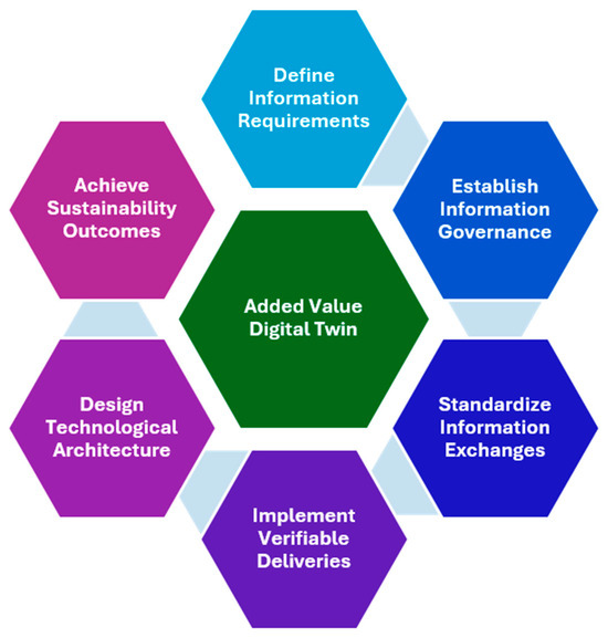
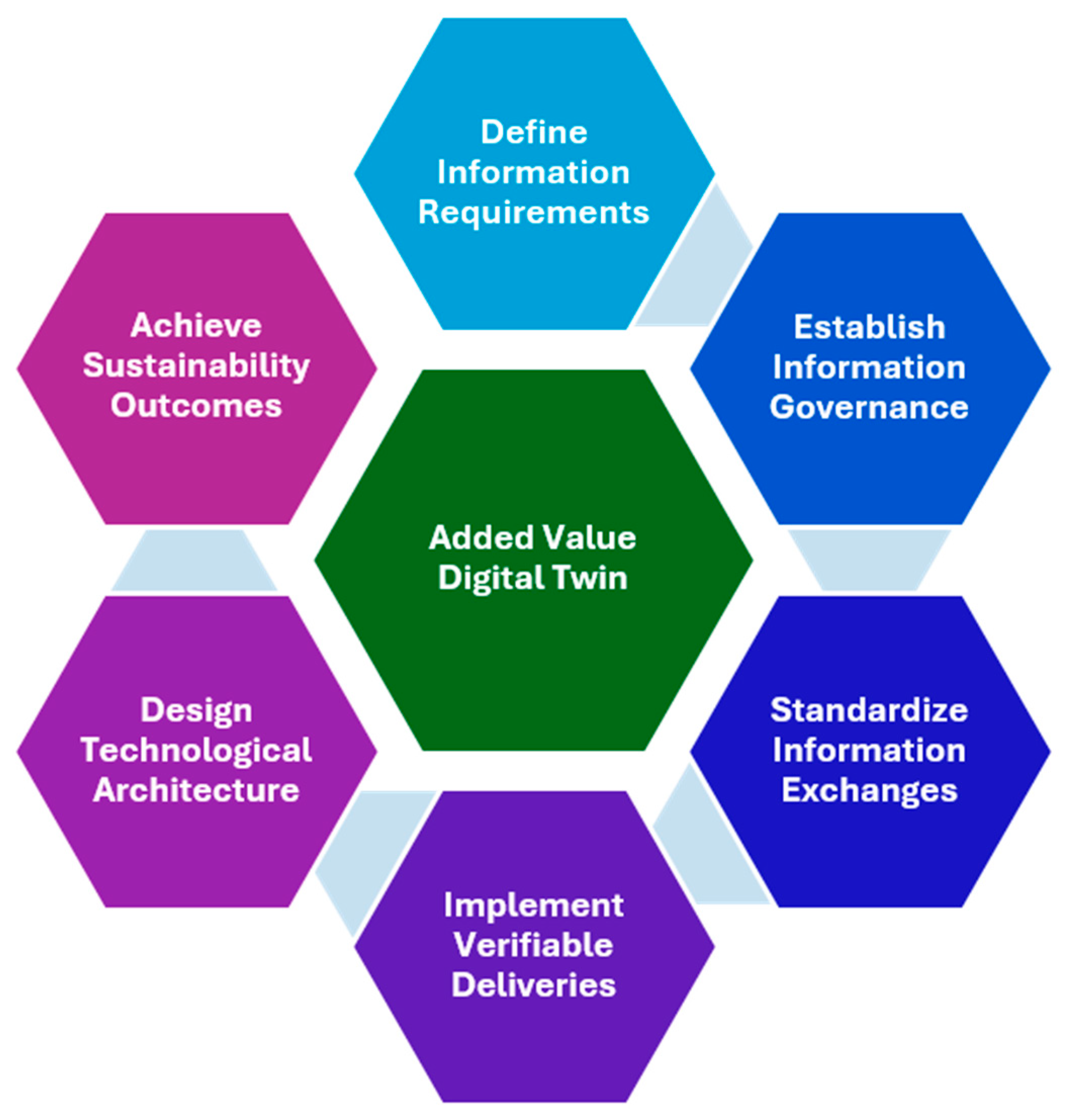
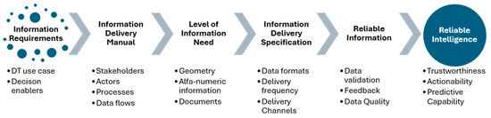
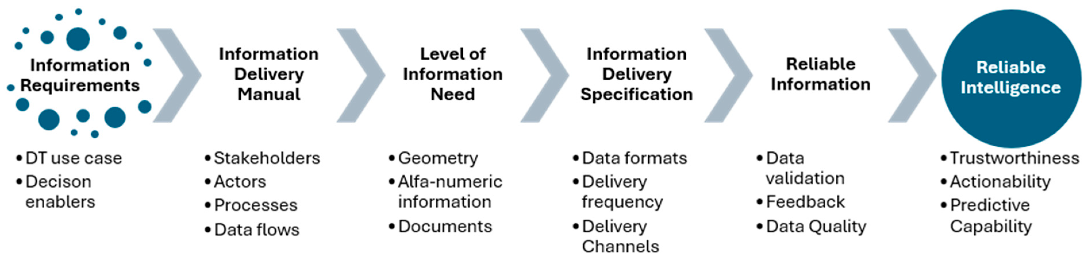
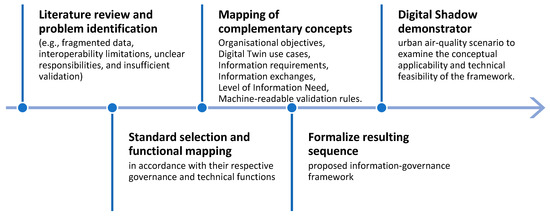
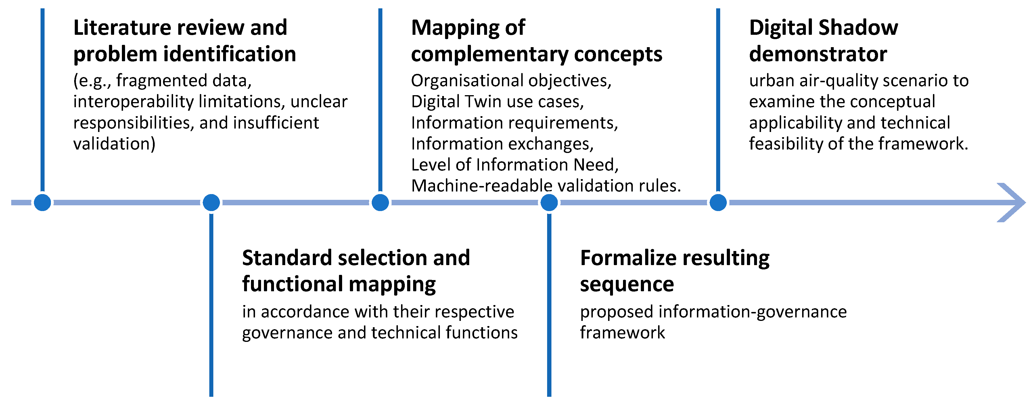

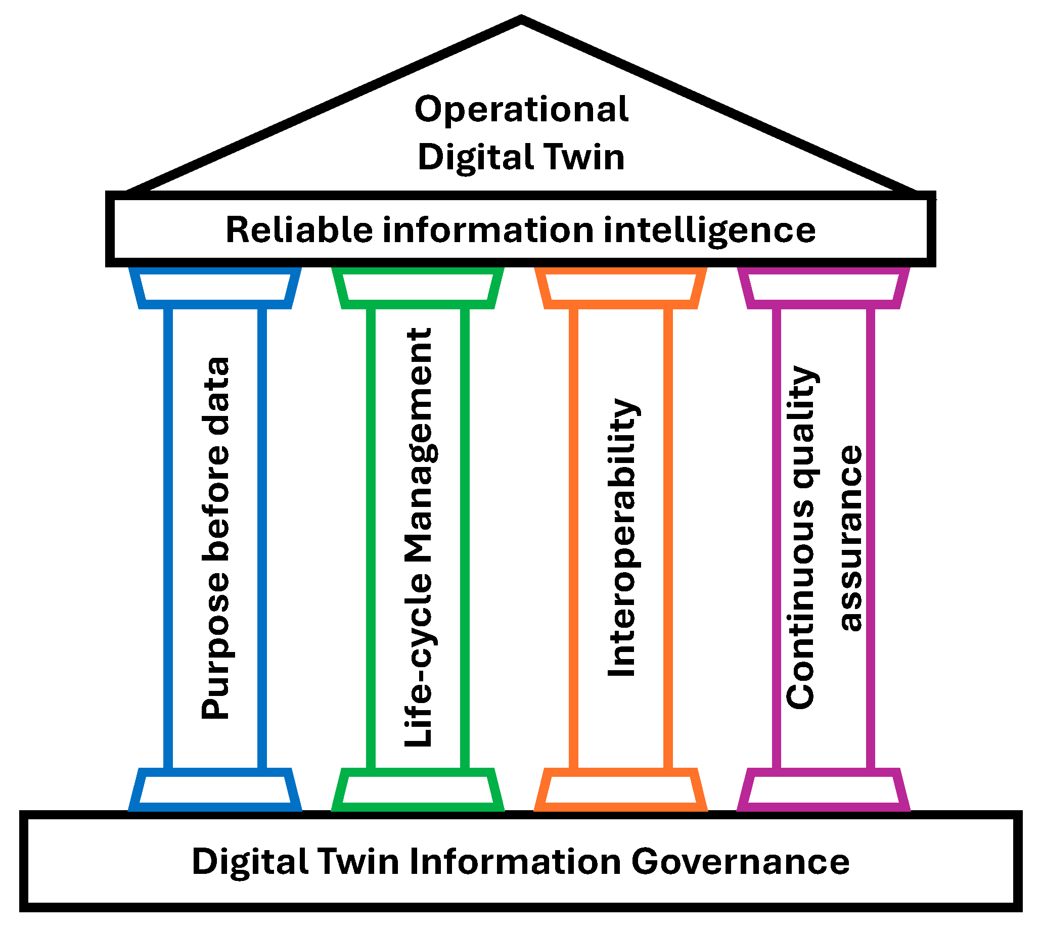
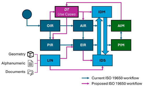
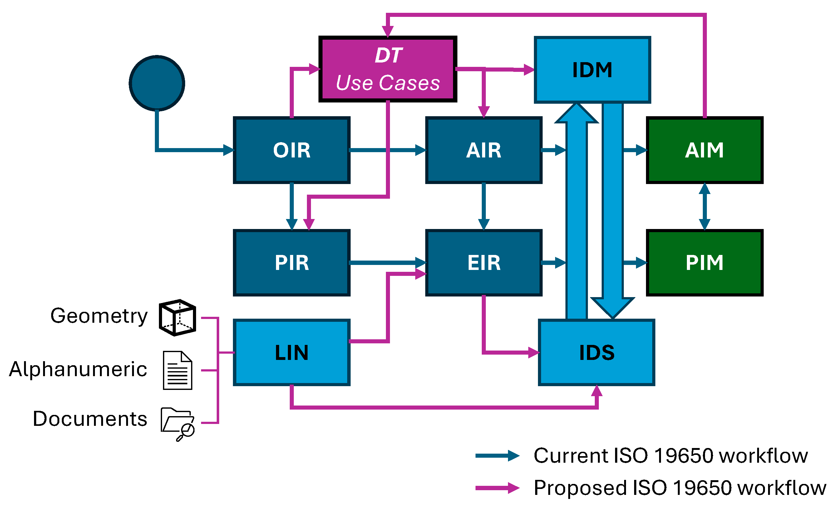
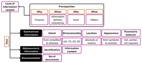
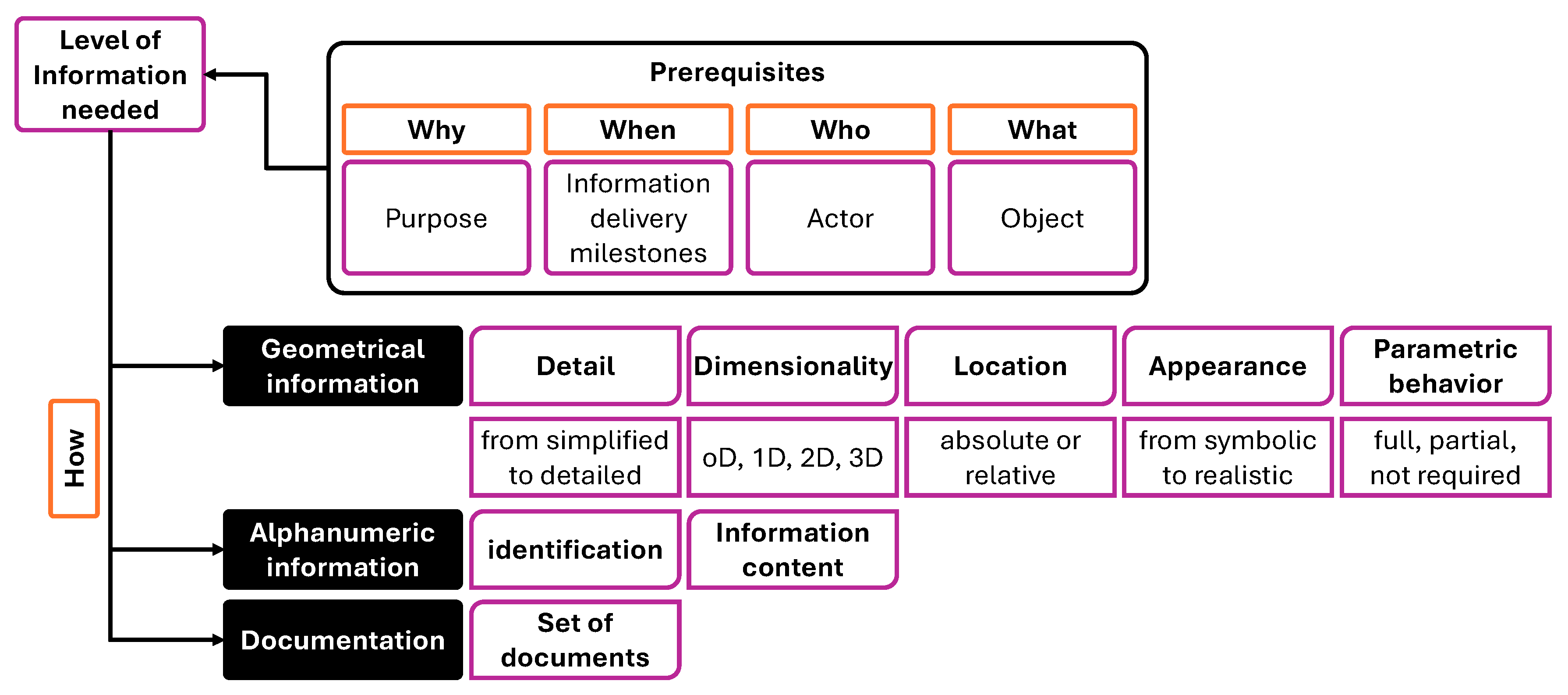
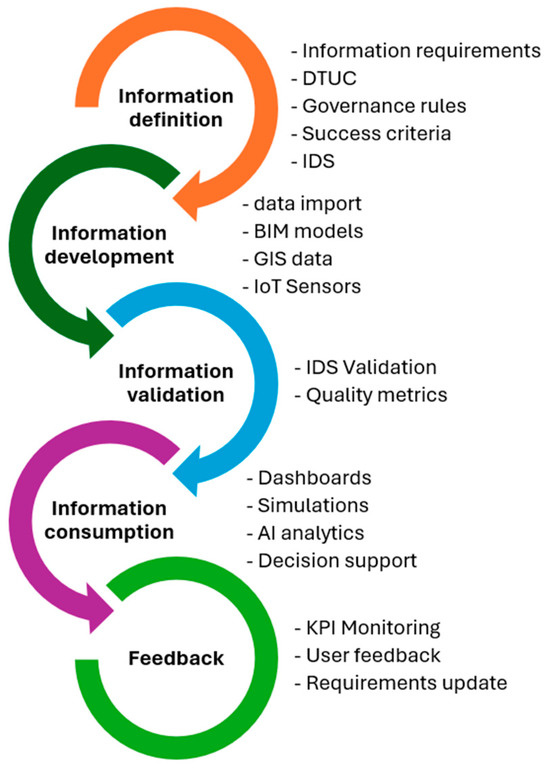
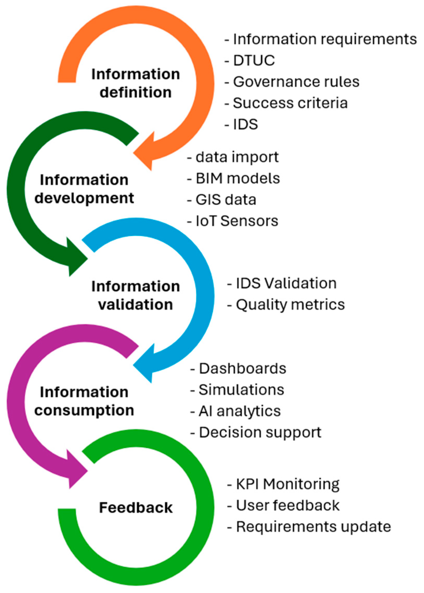
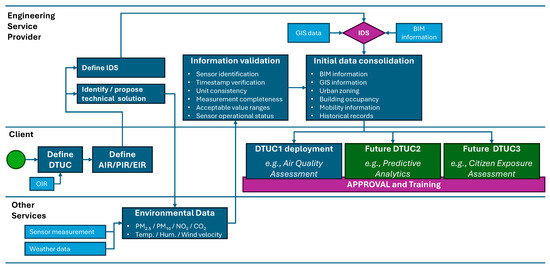
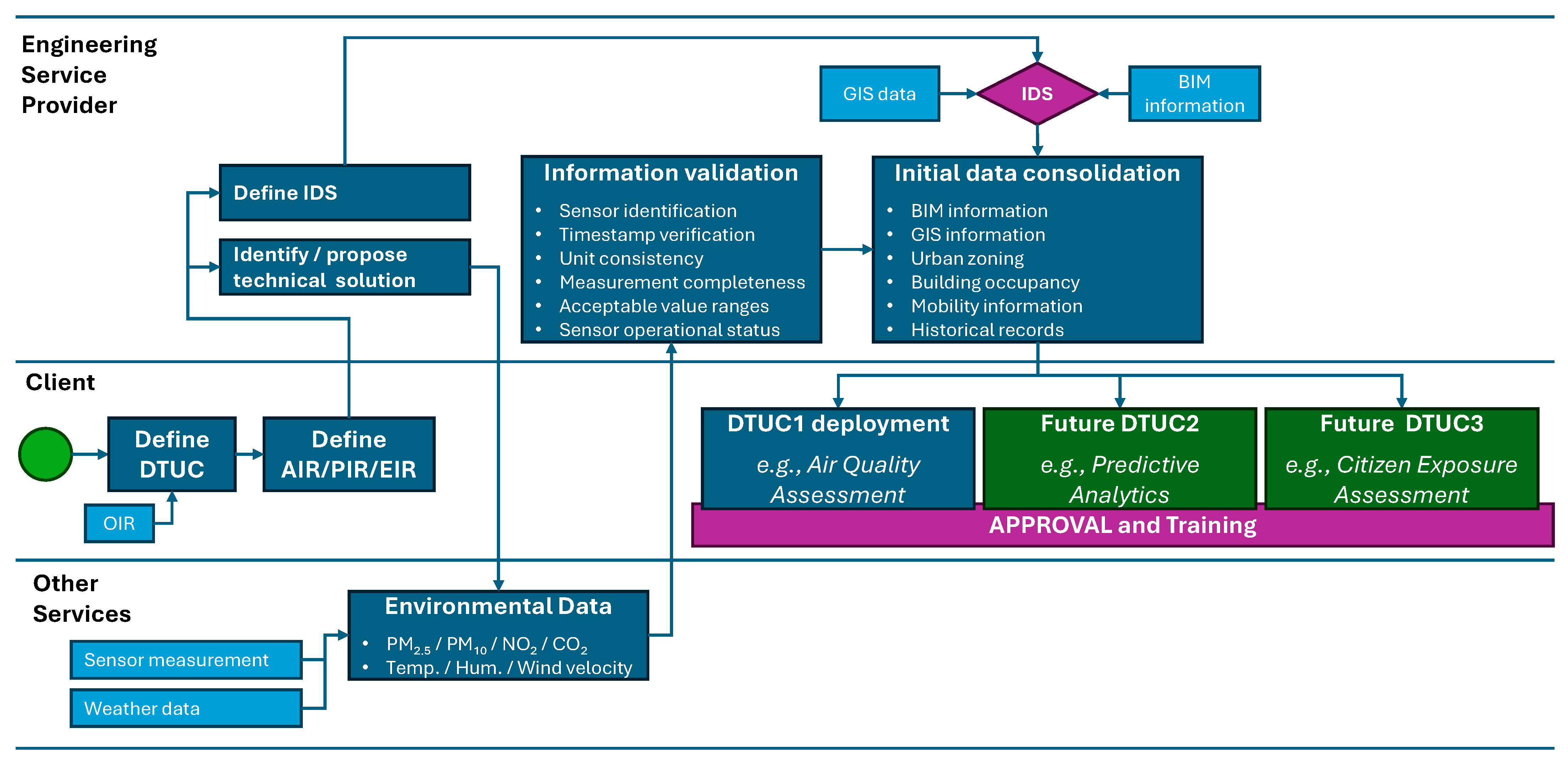
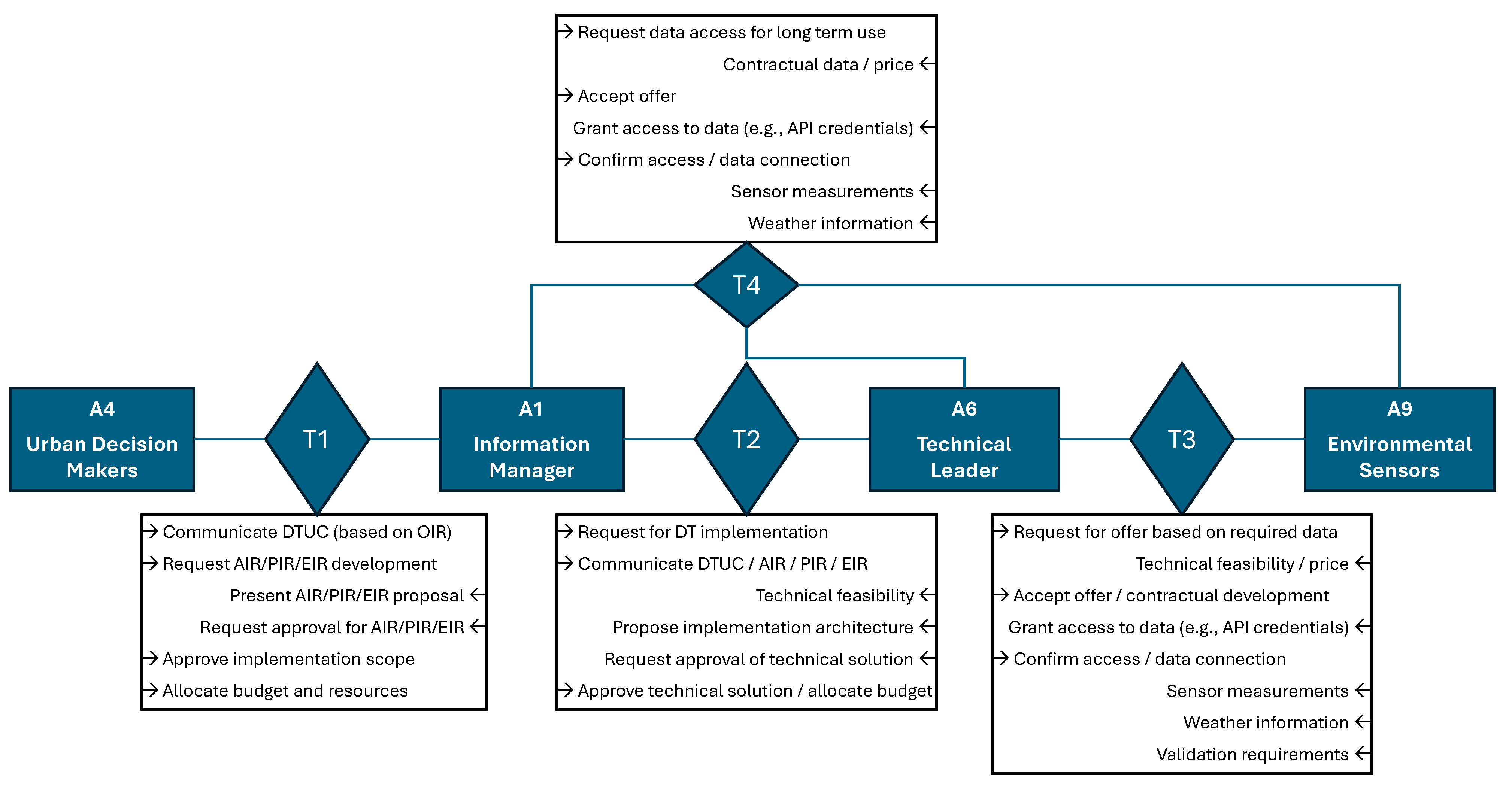
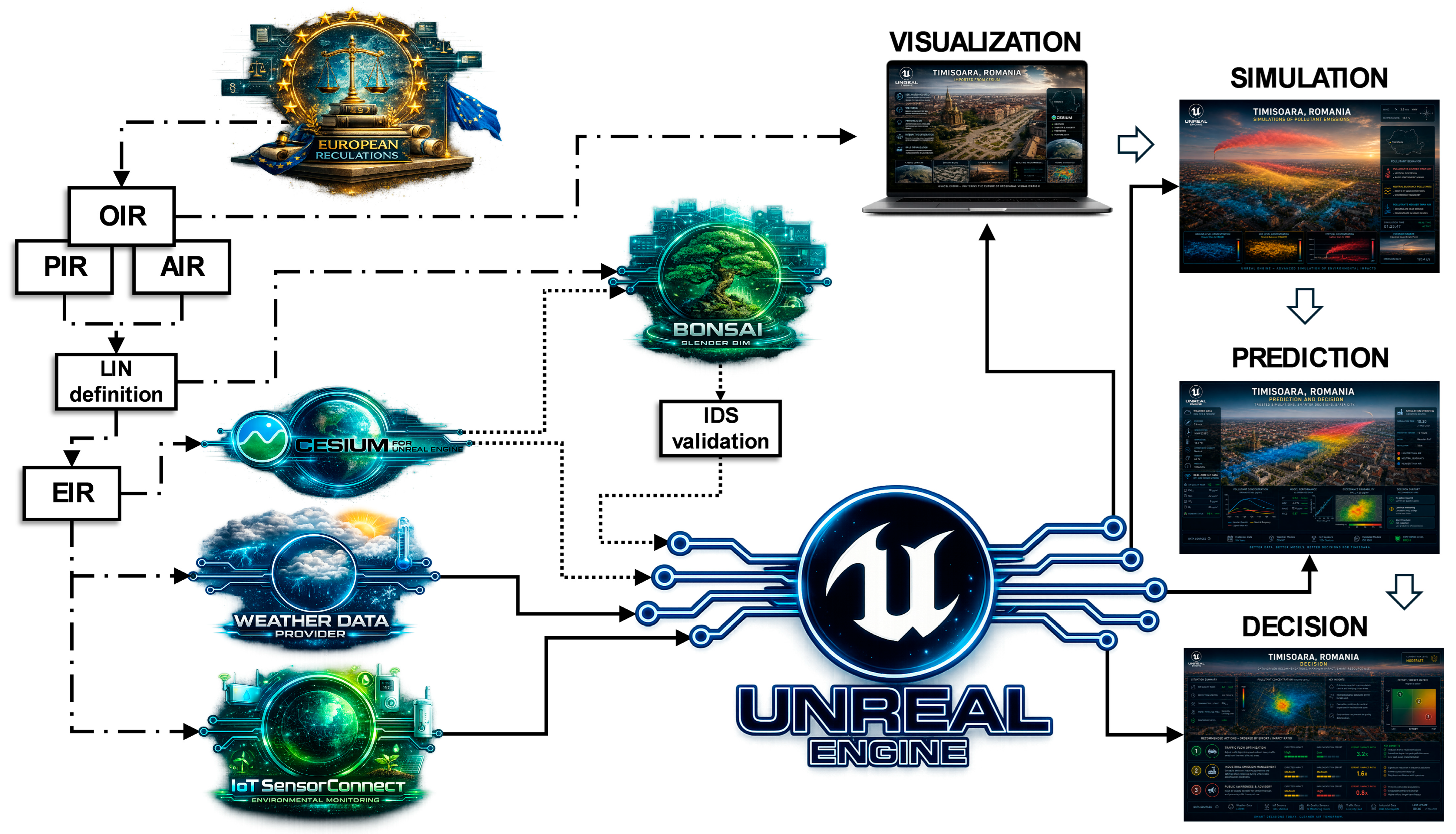
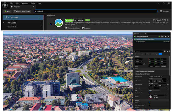
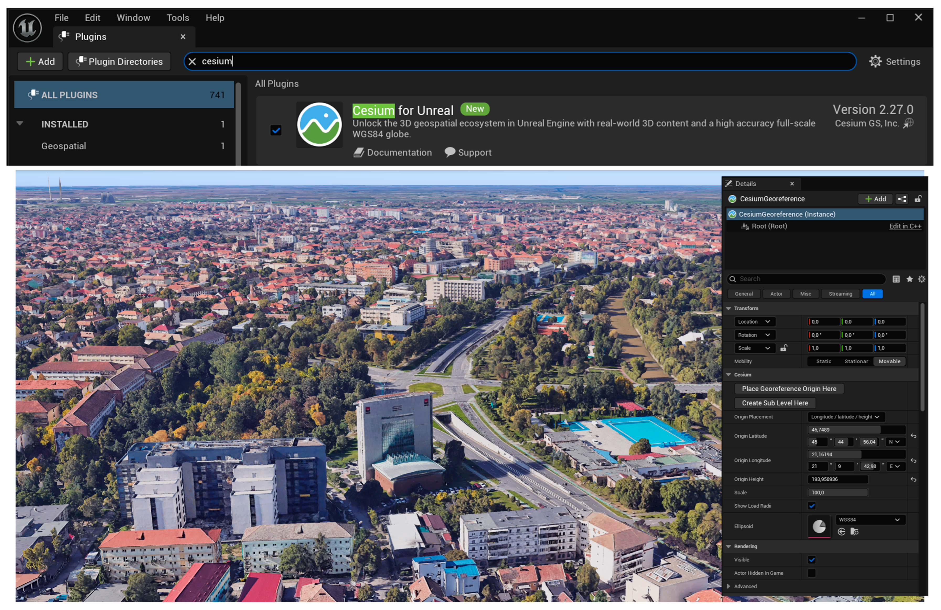
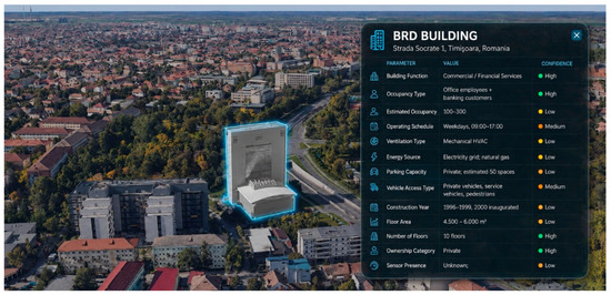
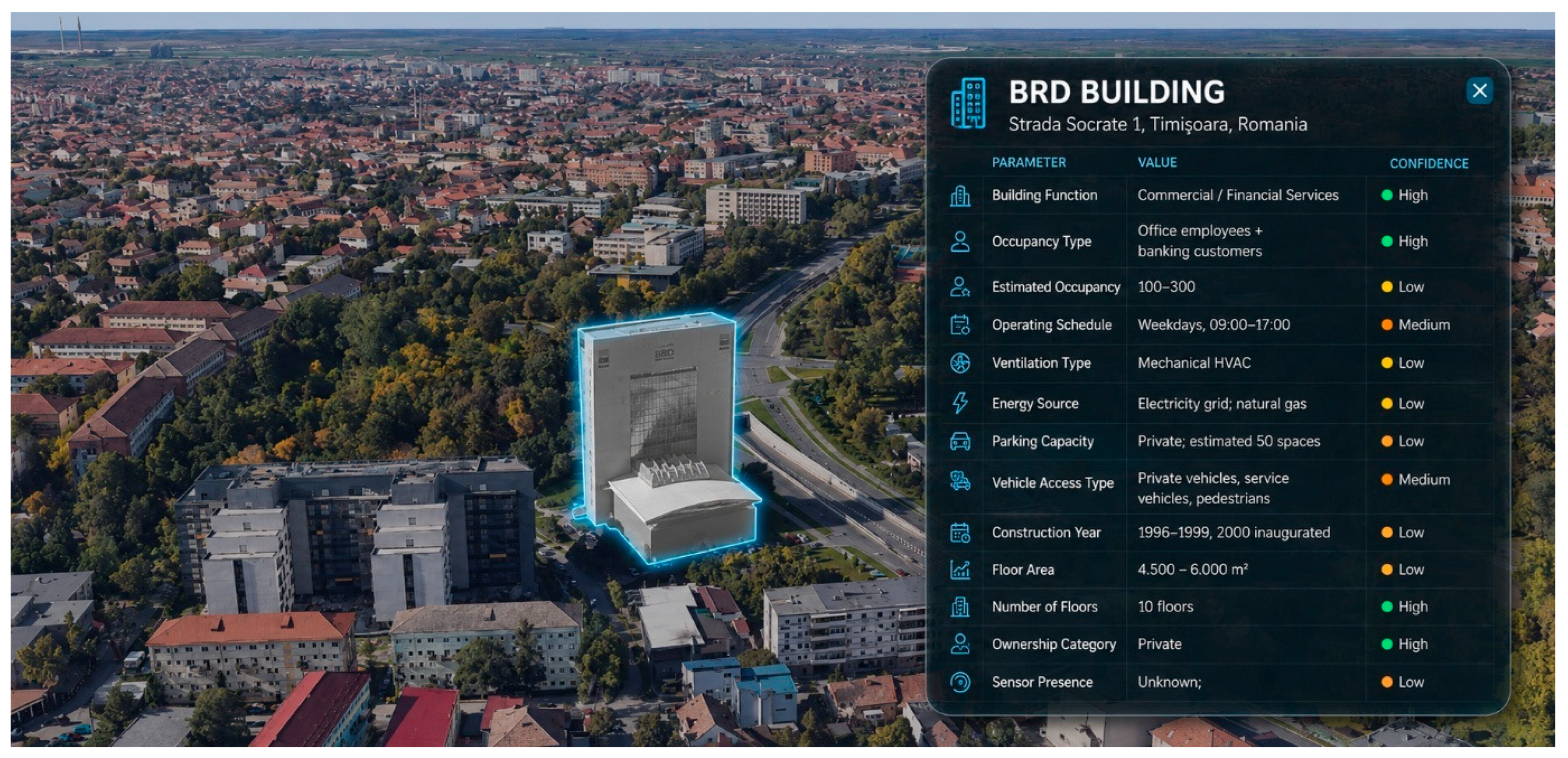
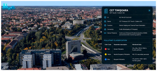
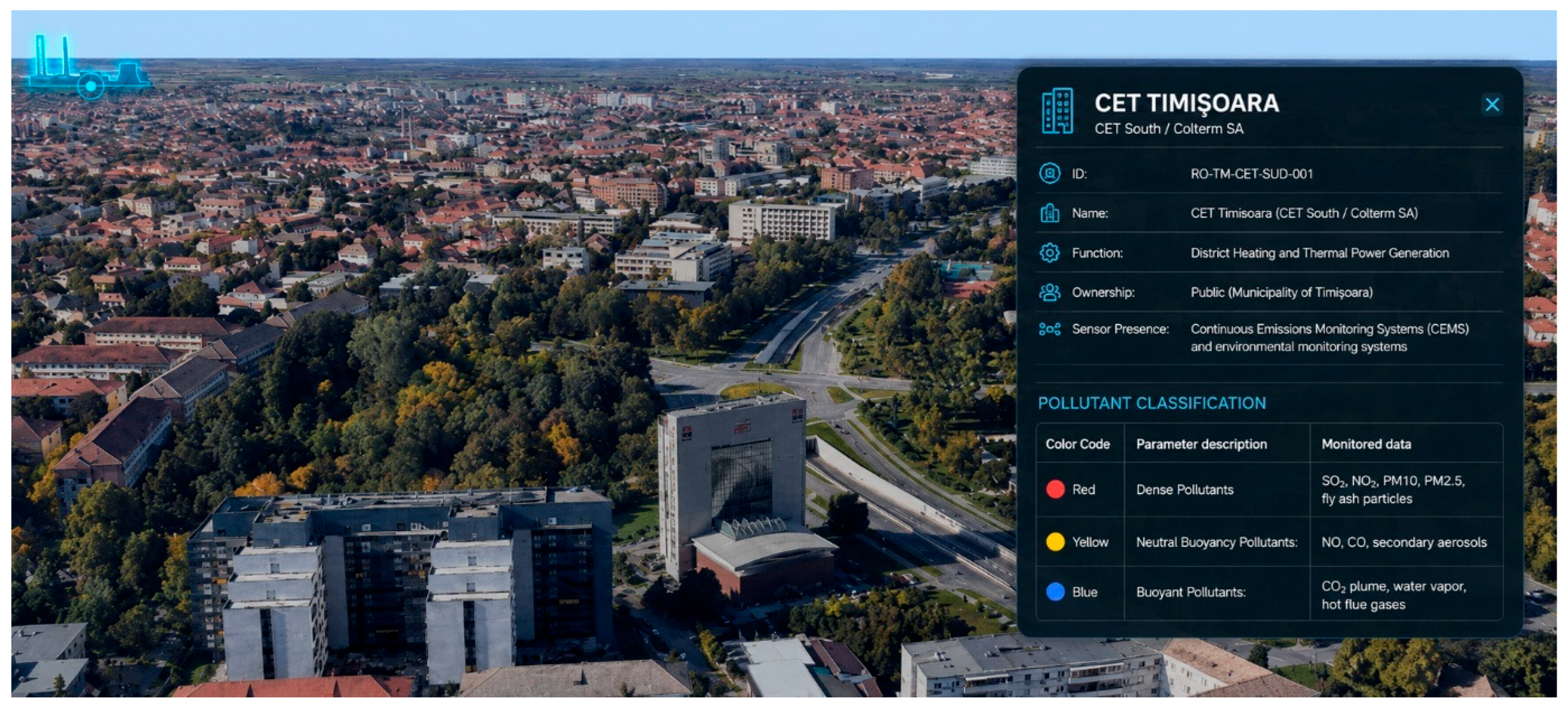
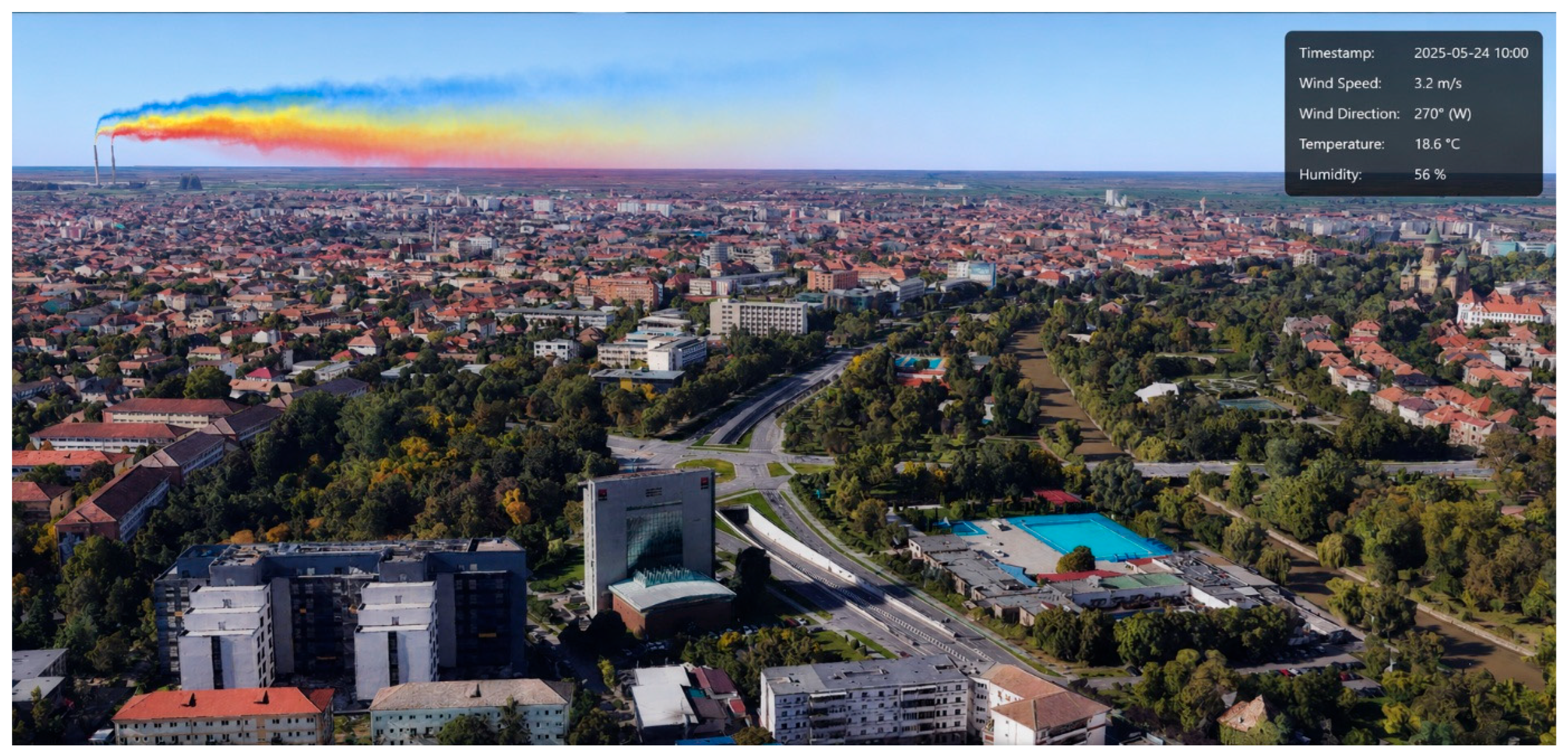
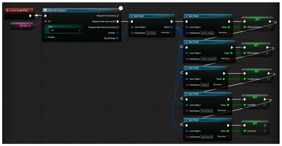
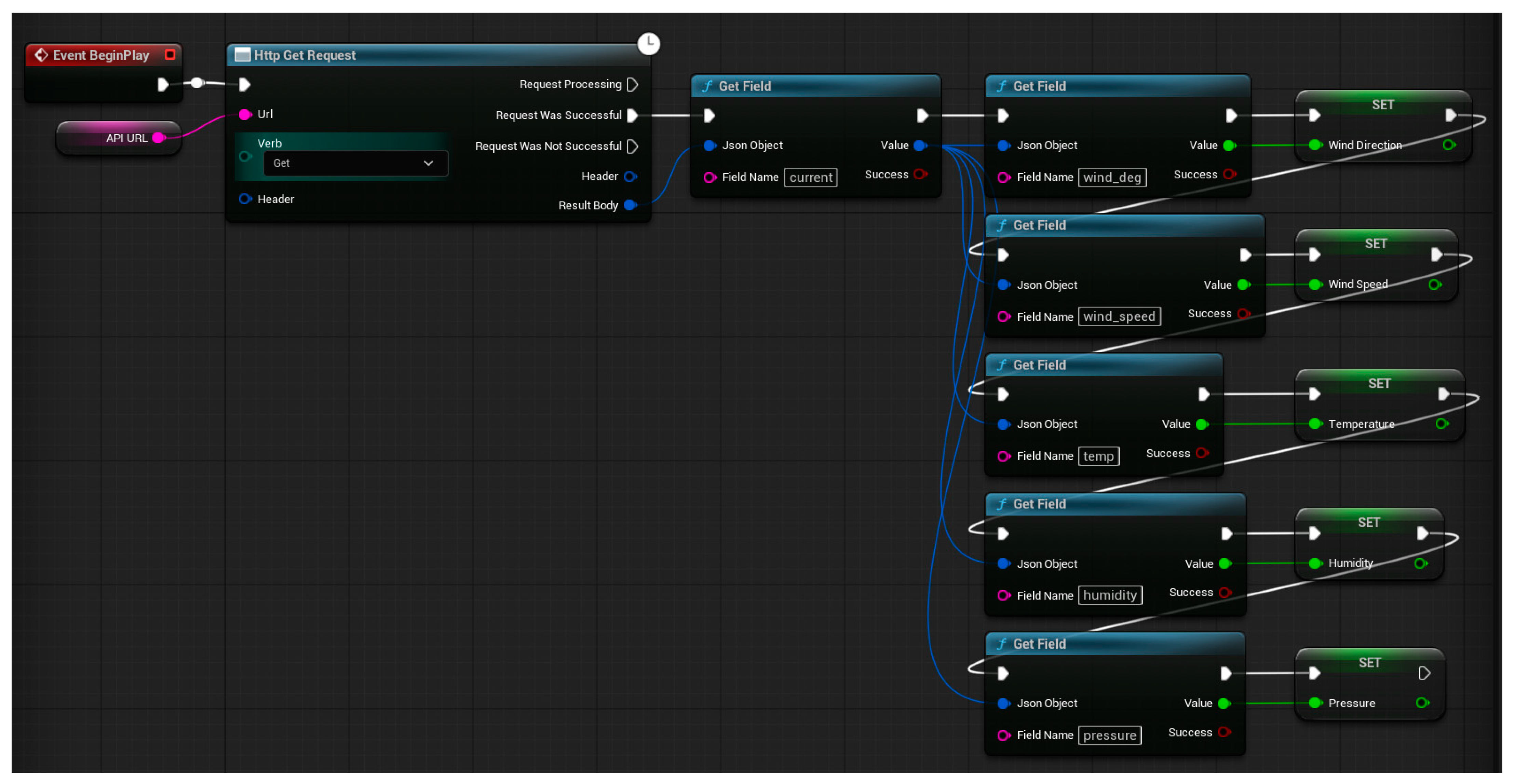
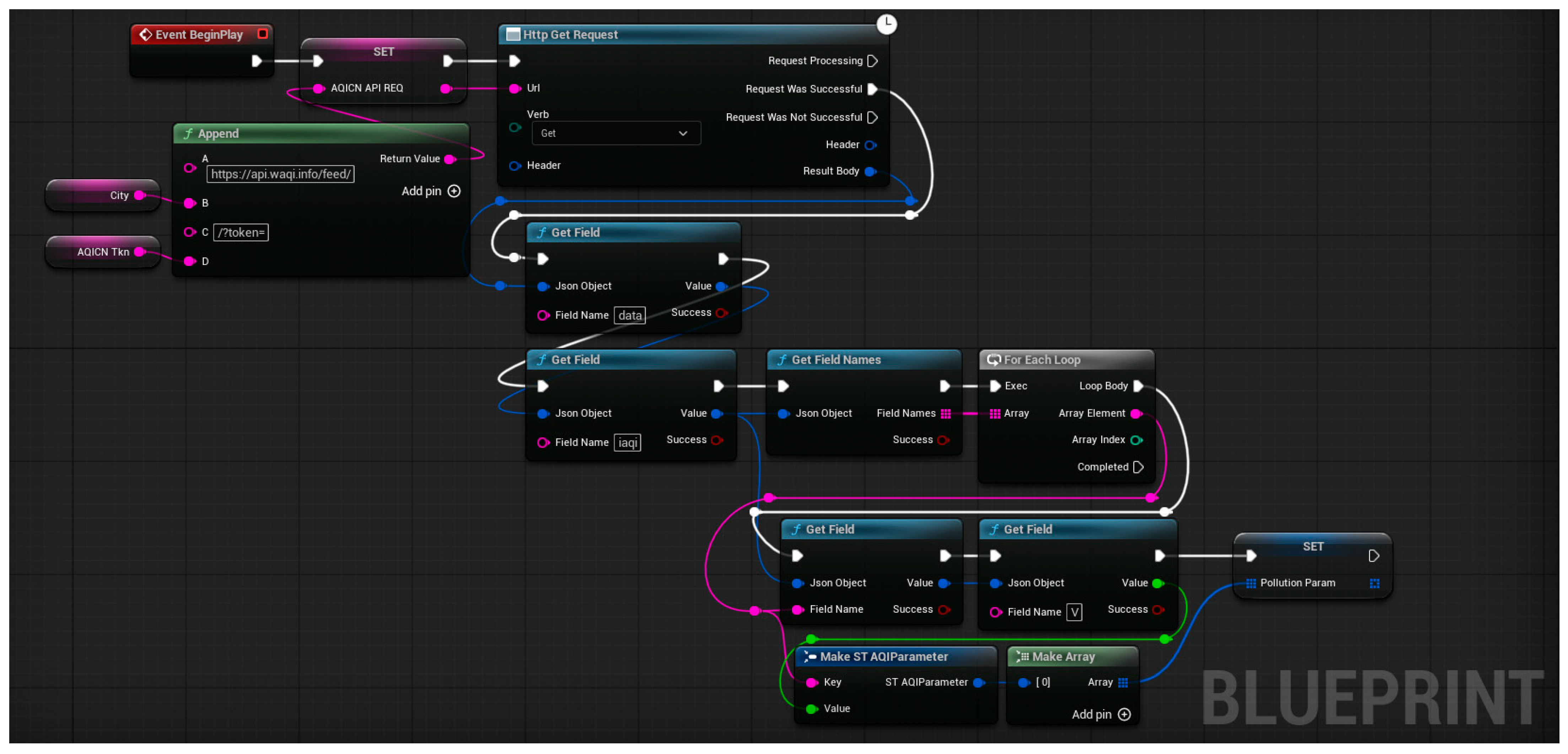

Disclaimer/Publisher’s Note: The statements, opinions and data contained in all publications are solely those of the individual author(s) and contributor(s) and not of MDPI and/or the editor(s). MDPI and/or the editor(s) disclaim responsibility for any injury to people or property resulting from any ideas, methods, instructions or products referred to in the content. |
© 2026 by the authors. Licensee MDPI, Basel, Switzerland. This article is an open access article distributed under the terms and conditions of the Creative Commons Attribution (CC BY) license.