


Abstract
Historic districts are represented through overlapping boundaries because street names, communities, heritage areas, and tourism destinations organize space differently. Huifang, a historic Hui Muslim neighborhood in Xi’an shaped by intercultural contact, makes this tension visible. Huifang, Huimin Street, and their English forms denote overlapping but non-identical spaces. This article examines how official renaming and restoration changed its street network and how names circulating in public sources reorganized the wider area. It analyzes 35 documented naming events and 54 dated Chinese- and English-language label observations coded by communicative role and referent scale. A name–space relations framework connects the evidence through restorative normalization and heritage compression. The findings show that political renaming in 1966 grouped seven earlier street segments under three shared names, while measures in 1972 and 1981 selectively restored earlier names and spatial distinctions but retained or adjusted other decisions. Names circulating in public sources grouped officially named streets into broader destinations or planning areas without replacing individual names. Huifang thus extends Chinese urban toponymy beyond name survival or restoration to examine whether associated spatial distinctions are preserved, restored, or obscured, and provides a basis for comparison across the Global Easts through substantive toponymic change under institutional continuity.
1. Introduction
When tourists enter the area behind the Xi’an Bell and Drum Towers, they are greeted by a dense cluster of restaurants, food stalls, and shops. Tourism documents usually identify this area as Huimin Street (回民街), while English-language travel guides often call it “Muslim Street.” Yet this visitor area does not correspond to one officially named road; it extends through Beiyuanmen and several adjoining streets that retain their own names. The visitor area lies within Huifang (回坊), a large and long-established settlement of the Hui, a predominantly Muslim ethnic group in China. Gillette (2000) and Imanaka (2014) use Huifang and Fangshang (坊上) for the wider neighborhood. Some public representations treat the food and shopping area commonly known as Huimin Street and promoted under that name as the whole of Huifang, though the spatial relationship between the two is not strictly defined.
This local naming ambiguity points to a broader change in the governance and representation of historic districts, where place names have become cultural assets and planning tools alongside their official function. Tourism promotion and online search also circulate the same names through domestic and international channels. Such uses do not necessarily organize place at the same spatial scale. The same urban district may contain several officially named streets while also being treated as a residential community. It may also be included within a heritage management area and promoted as a tourism destination, even though these spaces do not share identical boundaries. In China, the revised Regulations on the Administration of Geographical Names strengthened the requirements for the standardized use and historical documentation of place names with cultural value (State Council of the People’s Republic of China 2022). The subsequent implementation measures further specified responsibilities for the protection of place-name culture (Ministry of Civil Affairs of the PRC 2024). However, place-name standardization alone cannot determine what kind of spatial object different institutions and media make a name refer to. Without clarifying this question, the protection of historical place names may become detached from the changing spatial boundaries through which historic urban districts are governed and publicly represented.
In Huifang, this issue takes on particular significance, as the area is not a recent tourism precinct but a residential and commercial community with centuries of history. Its basic spatial pattern recognizable today was largely formed during the Ming (1368–1644) and was consolidated and expanded under the Qing (1644–1912) (Jia et al. 2026). Rather than following a fixed historical plan, its current form is the product of long-term adaptation (Zhao and Ren 2025). This history has also been drawn into contemporary narratives of Xi’an’s Silk Road past, which present the Hui community as evidence of long-standing intercultural and religious contact (Yang 2026). Today, Huifang is a major commercial and cultural tourism destination with an active street environment (Huang et al. 2023), but it remains a residential community rather than a heritage attraction stripped of residential life. The ambiguity of public names that alter or blur its boundaries shapes not only the image of a tourist site but also how the outside world sees a still-inhabited historic community.
Huifang’s long-standing street network has also undergone several official naming interventions. In 1966, political names were imposed on a street network formed through centuries of community life and urban administration. Measures adopted in 1972 and 1981 restored many earlier names and made further adjustments (Xi’an Municipal Place Names Committee and Xi’an Municipal Civil Affairs Bureau 1986, pp. 106, 112–13, 117–21). From the mid-1980s onward, tourism promotion began to use names such as Huifang and Huimin Street. Planning materials adopted area designations centered on Beiyuanmen and Lianhu, while English-language materials developed several forms for the area. These names did not always refer to the same streets or cover the same spatial range.
Huifang therefore offers a useful case for examining name–space relations in a historic urban district. Treating these names as interchangeable may reduce a historically layered and still-inhabited district to a single tourism image. It may also obscure the different spatial effects produced by official naming and public representation. It is therefore necessary to reconstruct which spaces these names distinguish or group together and to identify which institutions and forms of communication support these uses. This is important for recording toponymic history accurately and supporting responsible heritage practice.
The theoretical significance of this case is not limited to Huifang. Existing studies of street-name restoration often examine name change through political transition or institutional rupture, and post-socialist cities have provided an important empirical basis for this approach. The plural concept of the Global Easts connects the histories of East Asia and Eastern Europe without treating them as a single regional type (Lim 2022). City comparisons can also start from the specific history of a place rather than seeking cases where institutional conditions fully correspond (Robinson 2022). Huifang is therefore important not because it represents a unified type of Eastern city, but because it provides a specific case for examining toponymic change under institutional continuity. Against this background, the study asks the following two research questions:
- RQ1. How did official naming interventions alter Huifang’s existing street network, including the names assigned to individual streets and the segmentation of adjoining street sections?
- RQ2. How are the Chinese and English names associated with Huifang used in different contemporary contexts, and what spatial ranges do they refer to?
This study makes three interrelated contributions. First, it does not treat street segmentation and the referent scale of names as a spatial background established before naming occurs. Instead, it approaches them as constitutive dimensions of naming itself. The study therefore asks not only what a place name means but also how naming practices participate in constituting the spatial object to which the name refers. This focus on name–space relations extends research on Chinese urban toponymy beyond the origins and meanings of names toward the spatial consequences of naming.
The study also proposes two concepts that are analytically related but describe different historical mechanisms. Restorative normalization explains how earlier names and distinctions among street segments were selectively restored, while other naming decisions were retained, officially confirmed, or subsequently adjusted. Heritage compression works at another level. It explains how broader names circulating in public sources group several officially named streets without formally replacing their original names. The former concerns the reconstitution of official street units, while the latter concerns changes in the scale of public representation. Together, the two concepts show how different naming mechanisms can alter the relationship between names and urban space.
Third, the study establishes institutional continuity as an explicit axis of comparison, rather than assuming that all name restoration should be explained through institutional rupture. This approach allows Huifang to enter discussions of the Global Easts and comparative urbanism. At the same time, it avoids treating China as an incomparable exception, and it does not reduce China to a simple variation in post socialist transition.
2. Literature Review and Theoretical Framework
2.1. Political Renaming, Name Restoration, and Street Segmentation
Street names are rarely just neutral markers of location; they bring authorized versions of history into urban address systems and, through public signs and navigation tools, push political narratives into everyday experience (Azaryahu 1996). Their political effects do not end with formal approval; once they enter cultural representation and spatial practice, they continue to operate (Rose-Redwood et al. 2010). Political conditions thus shape both how a name is first assigned and how it is later replaced or restored (Rusu 2021).
This process involves more than fixing a name to a predetermined site. A name acquires authority through a naming dispositif, that is, through institutional procedures and the actors involved, while the same process also makes the spatial object legible (Giraut and Houssay-Holzschuch 2016). This perspective makes it possible to examine how naming participates in the constitution of the object being named. When political-toponymic research tracks change at the level of the named street, the spatial extent of that street often remains implicit while attention centers on the changing name form and its political meaning. That assumption becomes inadequate when one name extends across several adjoining segments that were previously recognized separately.
Street segmentation refers here to the way a continuous or interconnected street network is recognized as a series of separately named spatial units. When adjoining segments receive the same name, they may acquire a shared official identity. If their different names are later restored, the earlier distinctions among them may also regain official recognition. In such cases, more than the name of an existing street changes. The internal division of the street network changes as well. The analysis of street-name change therefore needs to consider both changes to the names themselves and changes in the spatial relations among named street units.
Name restoration is not necessarily a simple reversal of an earlier renaming. In post-socialist Bucharest, the restoration of street names formed part of the reconstruction of urban symbolic order following political rupture (Light 2004). Some names also continued in everyday use after losing official status through the persistence of habit and memory (Light and Young 2014). The location and institutional history of a street can shape its naming trajectory. Restoration therefore does not affect all streets in the same way (Rusu 2024). The reappearance of earlier names does not necessarily mean that the distinctions between the street segments to which they previously referred were also restored.
In Chinese cities, these questions arise within an institutional setting different from that of regime replacement. Urban renaming participates in the reconstruction of place meaning and identity (Ji 2018). Street naming in China has also been examined as a process through which cultural and political authority is inscribed in urban space (Feng et al. 2019). Research on foreign toponyms in China further shows how naming practices and their regulation reflect cultural politics and language ideologies (Shang and Yang 2023). At the same time, official and historical names may circulate alongside other public names, and this coexistence cannot always be reduced to an opposition between state power and popular resistance (Wu and Young 2023). Earlier names may return to official use through administrative action within the existing state framework, while community names and other names continue to circulate through different public contexts.
Research on political toponymy and name restoration has explained how street names acquire authority and how they are replaced, retained, or restored under changing political and institutional conditions. Less attention has been paid to whether naming interventions also redefine the spatial units to which street names refer. This question is particularly important when one name is applied to several adjoining street segments, because comparing the names used before and after an intervention cannot by itself reveal how the spatial relations between those segments changed. Likewise, the reappearance of an official name under institutional continuity does not necessarily recover an earlier name–space relation. The historical analysis of Huifang addresses this gap by tracing both changes in names and changes in how officially recognized street units were divided.
This account of official naming addresses only one part of the problem. Even when individual streets retain different official names, heritage planning and tourism communication may use a broader label to present several of them as one area. An analysis of name–space relations must therefore also consider how public representation regroups spatial units that administrative naming continues to distinguish. This process requires attention to heritage-making and to the spatial scale at which a broader name is used in public representation.
2.2. Heritage-Making, Translation, and the Spatial Reach of Names
Critical heritage research does not treat heritage as material that has simply survived from the past. Heritage concerns the ways in which the past is interpreted and used in relation to present concerns (Harvey 2001). Heritage value is therefore not an inherent property of an old place or material object but is produced through cultural meaning-making (Smith 2006). Heritage-making refers to a process of cultural production through which the past is given contemporary meaning (Ashley and Frank 2016). In this study, heritage does not mean age or historical survival alone. It refers to the public value assigned in the present to selected aspects of Huifang’s history and spatial form. Heritage-making denotes the practices through which that value is produced and communicated to contemporary audiences, and through which its spatial object is delimited. The analysis therefore considers not only what is preserved but also the institutional and social conditions under which particular histories acquire heritage significance (Winter 2013).
Heritage-making affects which histories become publicly visible and how urban space is divided or brought together. Place names are one means through which these spatial relations are organized. Tourism communication may extend a familiar street name beyond the street that legally bears it, allowing the name to identify a visitor route or a larger destination (Light 2014). Planning produces spatial relations differently. Once a boundary is drawn, streets and buildings with different names can be placed inside the same area of governance. The resulting heritage scale is not a fixed extent inherited from the past but is produced through contemporary practices of delimitation and connection (Harvey 2015). This process affects which sites and histories are presented together (Lähdesmäki et al. 2019) and may give selected historical names greater public visibility (Erőss et al. 2022).
The same area may consequently be represented by names with different origins and functions. Research on plural toponyms shows that names established through formal procedures can coexist with names formed through social practice, even when they operate differently (Giraut 2020). In Huifang, the names circulating in public sources include official street names used for addresses, community names grounded in local history and everyday practice, wider designations appearing in planning and heritage documents, and names circulated through tourism, media, academic research, and translation. These names need not be understood in advance as competing versions of a single stable place. The relevant questions here are how each name is used in a particular context and what spatial extent it makes recognizable.
A name may also refer to different types and extents of space in different sources. The same name may identify one street in one source but connect a visitor route or cover a multi-street area in another. The spatial reach of a place name may create scalar tensions between a locally embedded place and a wider field of circulation (Medway et al. 2019). The space to which a name refers is therefore not simply contextual information added after its meaning has been interpreted. It affects whether the name identifies a particular place or organizes several places into a broader public space.
Translation further complicates the relation between linguistic form and spatial referent by shaping how places are represented to different audiences (Song and Gu 2025). English generic terms such as Street and Quarter appear to carry different spatial implications, but they do not correspond consistently to a particular spatial extent in actual sources. The English name “Muslim Street” may refer to a short street segment or to a tourism destination composed of several streets. “Muslim Quarter,” in turn, may identify a residential community or a tourism area with no clearly stated boundary. The spatial implications of these translated names also depend on the heritage narratives into which they are incorporated. This relationship between translation and heritage representation becomes particularly visible in Chinese cities marked by histories of cross-cultural contact, although the histories involved differ.
In Tianjin, Victoria Park changed from an important site of concession life and British identity into a neglected space before being reinterpreted as part of the city’s heritage through urban redevelopment (Zhang 2023). Harbin’s Central Street followed another trajectory. De-Russification reduced the visibility of Russian street names and cultural signs, while Chinese, Russian, and English signage now works with Russian-style architecture and commercial imagery to make the city’s layered history visible as a tourist landscape (Gu et al. 2026). In the newly built tourism district of Cotai, translation also participates in organizing urban space. Casino names and bilingual signs work with architectural reproductions of European landmarks, allowing resort complexes separated by broad roads to be encountered as a shared landscape of global leisure (Song and Gu 2025).
In Huifang, these questions take a different form. Unlike the colonial contact histories represented by some of the preceding cases, Huifang reflects long-standing religious and commercial connections between China and the Muslim world. Its street network developed within a long-established Hui community, while its contemporary public image has increasingly entered Xi’an’s historical and cultural narratives. Imaginations of Tang Chang’an have been mobilized in urban renewal and tourism development, drawing Huifang into this process (Zhu 2018). The Belt and Road Initiative has given Silk Road history renewed significance in municipal planning and the built environment (Yang 2020). Within this narrative, the Hui community has become visible as evidence of multicultural exchange, while its religious and residential life has been represented more selectively (Yang 2026). These representations arise not from heritage policy alone but from its interaction with urban development and commercial practice (Zhu and Maags 2020).
Taken together, this scholarship shows that cross-cultural history becomes publicly visible as urban space is repeatedly reinterpreted and presented to contemporary audiences, with names and translation forming part of that process. Research on Xi’an places Huifang within this broader process by showing how urban renewal and Silk Road narratives have shaped its public representation. Existing scholarship has not, however, systematically established the spatial ranges of Huifang, Huimin Street, Beiyuanmen, and the planning designations applied to the area. Nor has it clarified where their boundaries overlap or diverge. The use of Chinese and English names in these representations therefore requires further examination, because similarity or difference in linguistic form is not in itself sufficient to establish whether the names refer to the same space. For Huifang, treating the spatial reach of a name as part of the naming process makes it possible to distinguish changes in the division of official street units from the regrouping of the wider area in public representation.
2.3. A Relational Name–Space Framework
Place names describe urban space, and naming practices also shape boundaries, internal relations, and public presentation of the spatial objects to which names refer. Critical toponymy approaches this process as spatial inscription, emphasizing how naming writes political meanings and social orders into urban space (Rose-Redwood et al. 2010). Giraut and Houssay-Holzschuch (2016) further shift attention from place names as finished forms to naming processes constituted through political contexts, actors, and naming technologies. Attention to scale extends this approach by asking over what spatial extent a name operates (Hagen 2011). Heritage scholarship shows from another direction that the boundaries and scales of places are formed through contemporary governance and representation (Harvey 2015). Together, these approaches allow the relation between a name and its spatial extent to be examined directly.
Huifang brings two forms of spatial change into view. Its official naming history involved more than the replacement of one street name by another. Some interventions placed previously differentiated adjoining segments under shared names, while later measures restored or adjusted some of those distinctions. Community names and planning designations subsequently came to identify overlapping areas of different extents. Tourism names and their English forms produced further spatial referents, while the official names of individual streets remained in use. A framework that assumes each name to have a stable spatial referent would therefore miss both the reorganization of official street units and changes in the scale of public representation.
The study accordingly follows two analytical paths in examining the relation between naming and spatial scale. The first considers how official naming altered distinctions between street units. The second considers how public representation changed the spatial extent within which several such units were presented together. Although both paths concern the same street network, they involve different forms of naming authority and different historical processes.
The first analytical path concerns the constitution of official street units. Political renaming may replace existing names, but it may also place several previously differentiated segments under one shared name. Name restoration may bring earlier names back into official use while re-establishing distinctions between street segments. The resulting naming system may nevertheless retain or confirm some later decisions. Restoration therefore cannot be assessed only by asking whether an earlier name reappeared. Existing research has shown that restoration is shaped by institutional selection and by the histories of particular streets rather than constituting a complete reversal of an earlier naming order (Rusu 2024). Huifang extends this problem to street segmentation by asking whether the return of a name also restored the formal distinction of the street unit with which it had previously been associated.
The term “restorative” draws on Azaryahu’s (2012) distinction between two orientations of street renaming. A future-oriented pattern inscribes a new political order into the urban namescape, whereas a restorative pattern reconnects it with an earlier naming order through the return of previous names. “Normalization” draws on recent research into toponymic standardization and officialization, which shows how historically variable name forms acquire formal status through institutional selection (Tort-Donada 2025). In Huifang, normalization concerned not only which name forms received official recognition but also the street segments to which they were assigned. Research on British Cyprus further shows how street renaming may contest and rework urban authority within a continuing institutional framework (Theocharous et al. 2026).
Drawing these theoretical strands together, this study calls this selective reconstruction of official naming relations in Huifang “restorative normalization”. The term “restorative” refers to the re-entry of earlier names and their associated segment distinctions into the official naming system. “Normalization” indicates that this return was accomplished through administrative selection, official confirmation, and subsequent adjustment. The concept does not imply the complete reinstatement of the street-name system that preceded political renaming, nor does every individual act of restoration constitute restorative normalization. It links changes in street names to the evolving spatial organization of the street network. Shared naming may bring previously differentiated segments into one official unit, and later restoration may re-establish distinctions between them.
The second analytical path concerns the public representation of a wider area. Community usage and planning practices may apply different names to overlapping parts of the same street network. Heritage governance and tourism communication can form other spatial combinations, while media, digital platforms, and translation carry these names into new communicative settings. Such names may coexist with official street names while bringing several streets together as a visitor route, tourism destination, community image, or managed area. Heritage-making can bring selected sites and histories into a shared field of representation (Lähdesmäki et al. 2019). Heritagization may also redistribute the public visibility of particular place names and the histories associated with them (Erőss et al. 2022). Tourism communication can extend a name beyond its formal referent and give it wider circulation (Light 2014). In Huifang, these processes converge when a broader public name makes the continuing distinctions among officially named streets less visible.
This study uses “heritage compression” to describe the reduced visibility of Huifang’s internal spatial differences in public representation. When a smaller number of names with broader spatial reach is used to represent the area, separately named streets may enter planning, cultural display, and tourism communication as a more unified spatial object. The heritage dimension of compression concerns how a historic district is selected, organized, and given public meaning through contemporary conservation, planning, and cultural representation. Whether a source formally designates Huifang as a heritage site is not a necessary condition for identifying this process. “Compression” refers to the diminished visibility of continuing differences in street names and functions within such wider representations. The physical street network remains in place, and the official names of individual streets may continue to be used.
The linguistic form of a name does not in itself demonstrate heritage compression. Although Street and Quarter may appear to indicate different extents, their actual referents may range from an individual street to a wider community or multi-street tourism area. Geospatial research on toponym use has similarly shown that the relation between a name and geographic space needs to be reconstructed from patterns of actual use (Hiraoka et al. 2025). Heritage compression therefore depends on the spatial referent produced in a particular context of use. It becomes evident when a name brings together streets or spatial functions that remain differentiated in official naming or in the area’s documented spatial history.
Restorative normalization and heritage compression are related but not equivalent. The former changes officially recognized street units through administrative intervention, whereas the latter groups several streets through broader institutional and communicative practices. They also belong to different historical processes. Later tourism and heritage names are not treated here as direct outcomes of earlier political renaming and restoration. Their connection lies in the historically continuous street network upon which both processes acted. The former altered how its internal units were distinguished in official naming, while the latter changed how those units were combined and made visible to different audiences.
Institutional continuity is treated here as the condition under which the effects of these two mechanisms accumulated, not as a third mechanism. It enables the study to examine how substantial changes in official naming and public representation accumulated without a change in political regime. Scholarship on the Global Easts provides an appropriate comparative context because it does not presume that cities shaped by socialism followed a single post-socialist trajectory (Müller and Trubina 2020). Within this framework, Huifang enters comparison through the two name–space mechanisms identified above rather than through its assignment to a predetermined regional type.
3. Materials and Methods
3.1. Study Area and Dataset Construction
This study uses a documentary-historical case study design with structured qualitative content analysis. The aim is to examine the historical transformation of Huifang’s street names and the contemporary use of names recorded in public sources. The materials are organized into two components within the Huifang Historical and Contemporary Naming Dataset. The historical component covers official changes to individual streets and adjacent segments from 1966 to 1981. For the contemporary component, the analysis traces how Chinese and English names were used for streets, visitor routes, communities, planning areas, and tourism destinations from the mid-1980s to July 2026. The study area lies within the Ming city wall, bounded by Xidajie to the south, Beidajie to the east, Lianhu Road to the north, and Anding Gate to the west.
The historical dataset contains 23 place objects. Among them, 17 are the core streets and lanes in the research area; the remaining 6 serve as boundaries or reference roads. This component also contains 35 object-level naming events, each supported by at least one historical evidence record. A total of 71 event–evidence links connect these events to the relevant historical evidence. These links jointly support the analysis of street renaming and its effects on street segmentation. The contemporary dataset, by contrast, contains 54 dated label observations extracted from 39 traceable sources. These observations allow for a comparison of how different names are used across contexts and what spatial ranges they refer to.
The units of analysis were documented naming events and dated label observations. The research focuses on how official naming interventions reshaped the street network and how names came to be used across different contemporary contexts. These questions turn on spatial, documentary, and representational evidence traceable through official records, planning documents, tourism documents, and media sources. Interview or survey data would address a different set of questions about individual perceptions or experiences. The study therefore did not collect such data or recruit participants. Its findings concern documented naming practices and public representations, not the perceptions of residents or visitors.
The historical materials draw on gazetteers, official toponymic records, local chronicles, scholarly studies, and other traceable documents. The 1986 Xi’an Gazetteer of Geographical Names records the main renaming and restoration events (Xi’an Municipal Place Names Committee and Xi’an Municipal Civil Affairs Bureau 1986). The National Database for Geographical Names records current official forms and several historical transitions (Ministry of Civil Affairs of the PRC 2026). Additional information on street locations, name origins, and earlier forms comes from the Xi’an local chronicles platform (Xi’an Local Chronicles Office n.d.). Gazetteers and official place name records are mainly used to confirm historical changes and current forms. Each historical record retains its source, publication details, page number or URL, and a brief description of the evidence it provides.
The contemporary corpus was compiled separately from the historical component. Searches used Chinese names including Huifang, Fangshang, Huimin Street, Xi’an Huimin Street, Beiyuanmen, and Huimin Historical District, together with the English forms “Muslim Street,” “Muslim Quarter,” “Huimin Street,” and “Hui Quarter.” Compound tourism, heritage conservation, and planning designations containing these terms were also included. The corpus retains only materials whose sources are traceable, whose name usage can be dated, and which offer enough information to judge how a name is used and what area it refers to.
A label observation consists of a specific name and the place it refers to in one source. When a source uses different name forms or applies names to different spatial objects, it can generate multiple observations. Publication dates and the dates associated with the names are recorded separately. For retrospective sources, the observation date follows the period described, while the publication date of the source remains unchanged.
3.2. Historical Event Construction and Analysis
Historical records were organized around stable place objects. Original name forms and suffixes, including Jie (街) for street and Xiang (巷) for lane, were retained in the source fields. Each record was matched to a possible event through the place object, date, earlier name, and later name.
Records of the same naming change affecting the same place were consolidated. Different stages in the naming sequence are retained as different events. For example, the political renaming of a street and its subsequent restoration are two events, not a combined record.
An event records the naming action that affects a place object at a specified time. Events were classified by year, earlier and later name, and type of action. These included political renaming, restoration, split restoration, directional naming, and official confirmation. Thirty-four events record a change from one name to another. The 1981 entry for Xicang East Lane records confirmation of an official directional form because the name had already returned in 1972.
The analysis also records changes involving adjoining street segments. Events were grouped when adjoining segments received the same name in the same year. Restoration events were also grouped when separate names returned to those segments in the same year. This grouping makes it possible to compare changes to individual street names with changes to the division of the street network.
When sources differed over a date, suffix, direction, or event type, page-specific gazetteer entries and official geographical-name records were used to determine the form adopted in the analysis. The resulting decisions and the supporting source for each event are recorded in the dataset.
3.3. Contemporary Label Coding and Analysis
Each label observation records a name form, language, label time, source, contextual description, communicative role, referent scale, and two content scores. Labels were grouped into six families. These are Huifang/Fangshang, the Huimin Street family, compound brand names, administrative or planning designations, English Quarter forms, and English Street forms. The mid-1980s name Hui food-and-drink street was included in the Huimin Street family as a related commercial variant. It was excluded from counts of the exact form “Huimin Street”.
Each observation was coded from the wording and spatial description in its source using the coding dictionary included in the dataset. The five communicative roles are community and identity; scholarship and analysis; governance, planning, and heritage; tourism, media, and platform branding; and translation and international communication. The five referent scales are street or segment; route or itinerary; community or district; planning or heritage area; and destination, attraction, or mixed scale.
The coding followed how a label was used in each source, not the family to which it belonged. The same label could receive different referent-scale codes in different sources. Translation and international communication were assigned only when the source involved explicit translation or cross-language communication. Street or segment referred to one named street or a short linear section, while route or itinerary required a route or a connected sequence of stops. Community or district covered a lived neighborhood or a multi-street area. Planning or heritage area required documented use in planning, conservation, or governance. Destination, attraction, or mixed scale applied when a source presented the place as a visitor destination or used one name for an area extending across several spatial ranges.
Observation counts were tabulated for each label family by communicative role and referent scale. Two content variables were used for a further comparison. Heritage depth is scored from 0 to 3. A score of 0 indicates that historical, community, and conservation content is absent, while a score of 3 indicates that such content forms a substantial part of the source. Food-tourism salience uses the same 0–3 scale. A score of 0 indicates that food-tourism content is absent, while a score of 3 indicates that it dominates the presentation. For each variable, the analysis reports the number of observations in each label family that received a score of 3.
The reported counts can therefore be checked against the observation-level records and the coding dictionary supplied with the dataset.
4. Findings
4.1. Historical Renaming, Restoration, and Changes in Street Segmentation
Before the political renaming campaign, Huifang comprised streets and lanes whose individual names expressed distinct spatial relationships. Around the former Yongfeng Cang (granary), a group of lanes shared the directional name Xicang, linking them to the granary. Miaohou Street marked its position behind the City God Temple, while Daxuexi Lane and Xiaoxuexi Lane formed a pair of adjacent street names. Across the wider network, street names distinguished markets, landmarks, institutions, directions, and the boundaries of individual segments (Xi’an Municipal Place Names Committee and Xi’an Municipal Civil Affairs Bureau 1986, pp. 106, 112, 117–19).
The historical component contains 35 object-level naming events dated to 1966, 1972, and 1981. Thirty-four events record a transition from one name to another; the remaining event, dated to 1981, records the official confirmation of Xicang East Lane, whose name had already been restored in 1972. Table 1 summarizes the distribution of these events over the three years, and the main actions recorded in each year.
Table 1.
Chronology of object-level naming events.
The largest group of events dates to 1966. Of the 17 events recorded for that year, 10 directly replaced one street name with another. Gazetteer entries document six of these changes: Huajue Lane to Geming Yixiang, Beiguangji Street to Fenglei Road, Xushimiao Street to Honghu Street, Maixian Street to Lixin Street South, Xicang East Lane to Lizhi Lane, and Xiaoxuexi Lane to Xuexi Lane (Xi’an Municipal Place Names Committee and Xi’an Municipal Civil Affairs Bureau 1986, pp. 112–13, 117–19, 121). The dataset lists three further changes, from Beidajie to Yan’an Road, Xidajie to Fandi Road, and Lianhu Road to Dongfanghong Road. The National Database for Geographical Names documents the change from Mashenmiao Lane to Laowu Lane (Ministry of Civil Affairs of the PRC 2026).
The other seven events affected the naming of adjoining street segments. Erfu Street, Hongbu Street, and Jiaochangmen were all grouped under the name Hongwei Street; Xiyangshi and Miaohou Street were recorded as Hongge Street; and Damaishi Street and Sajinqiao were assigned the name Qianwei Road. In the process, seven separate street names were reduced to three shared ones.
Fourteen pre-1966 names returned in 1972. Seven were the names listed in Table 2. Their restoration replaced the three shared names introduced in 1966 and again distinguished the adjoining street segments. The other seven restored names were Beidajie, Xidajie, Huajue Lane, Beiguangji Street, Maixian Street, Xicang East Lane, and Lianhu Road. Gazetteer entries provide page-specific evidence for eleven of the fourteen restorations, including the restoration of Xiyangshi (Xi’an Municipal Place Names Committee and Xi’an Municipal Civil Affairs Bureau 1986, pp. 106, 112–13, 117, 119, 121).
Table 2.
Shared names assigned to adjoining street segments in 1966.
The four events recorded in 1981 were less uniform. Xushimiao Street regained its earlier name after fifteen years as Honghu Street (Xi’an Municipal Place Names Committee and Xi’an Municipal Civil Affairs Bureau 1986, p. 117). Xiaoxuexi Lane also returned after having been recorded as Xuexi Lane since 1966 (Xi’an Municipal Place Names Committee and Xi’an Municipal Civil Affairs Bureau 1986, pp. 118–19). The remaining two events concerned the directional Xicang names. Xicang South Lane received its formal name as part of this group. The event for Xicang East Lane confirmed a name that had already been restored in 1972 (Xi’an Municipal Place Names Committee and Xi’an Municipal Civil Affairs Bureau 1986, p. 119). The continuing formal differentiation of the four directional Xicang lanes is visible in their contemporary street signs (Figure 1).
Figure 1.
Contemporary street signs for the four directional Xicang lanes: (a) Xicang North Lane; (b) Xicang West Lane; (c) Xicang South Lane; and (d) Xicang East Lane.
The earlier street-name pattern was not fully restored. Laowu Lane retained the name introduced in 1966 rather than reverting to Mashenmiao Lane, as confirmed by the National Database for Geographical Names (Ministry of Civil Affairs of the PRC 2026). The Xicang directional forms named or confirmed in 1981 also remained part of the later official pattern.
Of the 35 events, 31 occurred during two connected rounds in 1966 and 1972. Fourteen of these events formed a matched sequence across the three shared-name groups. The remaining 17 events in these two years record direct changes and restorations for individual streets. The 1981 records differ from both earlier rounds, combining two delayed restorations with the naming or confirmation of directional Xicang forms. The matched sequence was therefore spatially consequential: the 1966 measures reduced seven separately named segments to three shared official units, while the 1972 restorations re-established seven distinct named units.
4.2. Contemporary Label Use Across Contexts and Spatial Ranges
The contemporary corpus contains 54 dated label observations extending from the mid-1980s to 2026. Six observations date from 1985 to 1999, six from 2000 to 2009, 22 from 2010 to 2019, and 20 from 2020 to 2026. The records document the continued use of several kinds of names rather than a continuous succession from one dominant label to another.
From the earliest observations, a commercial street already stood apart from the wider community area. In the mid-1980s, Gillette records an officially designated Hui food-and-drink street on Damaishi Street. The label pointed to a linear commercial space centered on food retail. During fieldwork in 1994–1995, Gillette also recorded Huiminfang and Fangshang as names for the community and its surrounding neighborhood (Gillette 2000, pp. 23–24, 56).
Heritage projects added other forms. A 2003 report on the Sino-Norwegian conservation project used Xi’an Muslim Historical District in its title, framing the area as a historical district (Baracca 2019, p. 82). A 2005 report used the name Beiyuanmen Huifang Cultural Customs Street, combining a specific street name with Huifang and the language of cultural display (Xinhua News Agency 2005). These names became part of heritage conservation and public cultural presentation without displacing the community and commercial names already in use.
By 2009, Huimin Street appeared in both academic and tourism sources. An academic study used the name in a discussion of heritage and tourism (Xu and Wan 2009), while a visitor-oriented tourism page also used it that year (Go2C 2009). In 2014, the People’s Daily Overseas Edition presented Huimin Street as a snack-street attraction (People’s Daily Overseas Edition 2014). A 2015 report instead used Xi’an Huifang to describe the wider multi-street community within a food-tourism narrative (People’s Daily 2015). These sources show that food-tourism framing was associated with both Huimin Street and Huifang, although the two labels did not refer to the same type or scale of place.
Figure 2 compares the six label families across five communicative roles and five referent scales. Tourism, media, and platform branding is the largest role category, with 20 observations. Destination, attraction, or mixed scale is the most frequent referent category, with 17 observations, followed by community or district scale, with 16.
Figure 2.
Distribution of six label families across five communicative roles and five referent scales. Cell values are coded observation counts, n = 54. Within each panel, darker shading indicates higher observation counts. Source: Huifang Historical and Contemporary Naming Dataset.
Of the 18 Huifang/Fangshang observations, seven occur in community and identity contexts, two in scholarship, three in governance or heritage work, and six in tourism or media. Eleven refer to a community or district, three to a route, two to a planning area, and two to a destination or mixed-scale area.
The 21 observations of the Huimin Street family are distributed differently. In terms of spatial scope, 12 point to destinations or mixed-scale areas, and the remaining 9 are scattered among streets, routes, communities, and planning areas.
Content coding presents a similar pattern. Among the 18 Huifang/Fangshang observations, nine received the highest score for heritage depth, compared with four of the 21 observations in the Huimin Street family. The pattern was reversed for food-tourism salience. Fifteen observations in the Huimin Street family received the highest score, compared with five Huifang/Fangshang observations. These scores indicate a difference in emphasis. Huifang also appears in tourism materials, while Huimin Street also occurs in academic and administrative sources.
The contrast is also visible in individual observations. The observation associated with the 2003 conservation report, documented in Baracca (2019, p. 82), was assigned a heritage-depth score of 3 and a food-tourism salience score of 0 in this study. The 2014 People’s Daily Overseas Edition report received the reverse scores because it presented Huimin Street as an approximately 500-m snack-street attraction (People’s Daily Overseas Edition 2014).
Administrative and planning designations are less frequent, but their boundaries are more clearly defined. The naming of Lianhu Historical District (Huifang) in 2016 combines planning terms with existing local names (Xi’an Municipal People’s Government 2016). An official conservation plan issued in 2021 designated the Beiyuanmen Historical and Cultural District as a defined area of heritage protection (Xi’an Municipal People’s Government 2021a).
A district-level account published in 2022 used this designation to organize the histories of several streets (Lianhu District Bureau of Culture, Tourism and Sports 2022). These planning designations defined areas for conservation and administration without changing the official names of the streets within them (see Figure 3).
Figure 3.
Contemporary signs and streetscapes of four separately named streets within Huifang: (a) Xushimiao Street; (b) Miaohou Street; (c) Xiyangshi; and (d) Damaishi Street.
The nine English-language observations also differ in spatial range. The corpus contains five Quarter forms and four Street forms. Three of the Quarter observations refer to a community or district. Of the remaining two, one refers to a street and the other to a destination or mixed-scale area. Among the Street observations, one refers to a single street, one to a visitor route, and two to destinations comprising several streets.
Some English-language sources distinguish the two terms. A 2013 China Daily article places Muslim Street within the larger Muslim Quarter (Mu 2013). A Shaanxi government page published in 2017 uses Muslim Quarter for the wider area and describes Beiyuanmen Muslim Street as a market street about 500 m long (Shaanxi Provincial People’s Government 2017a). Quarter refers to the neighborhood in these sources, while Street identifies a route or market segment within it.
Other official sources use Street for a much larger area. Another Shaanxi government page from 2017 applies Xi’an Muslim Street to a destination that includes Beiguangji Street, Beiyuanmen, Xiyangshi, Dapiyuan, Huajue Lane, and Sajinqiao (Shaanxi Provincial People’s Government 2017b). An official Xi’an government page published in 2021 presents Huimin Street and Muslim Quarter as alternative English names for the same attraction (Xi’an Municipal People’s Government 2021b). As these sources either equate Street with a wider attraction or explicitly list several separately named streets under it, the observations were coded as destination, attraction, or mixed-scale uses rather than as single-street uses. Contemporary wayfinding makes these relationships visible through two broader spatial frames: Huifang and the Beiyuanmen Historical and Cultural District (Figure 4).
Figure 4.
Contemporary wayfinding systems that organize the wider area through different spatial frames: (a) a Huifang sign directing visitors to Gulou, Huajue Lane, Xiyangshi, Shehui Road, and Beiyuanmen; and (b) a Beiyuanmen Historical and Cultural District map and directional sign identifying Tuche Lane, Maixian Street, Erfu Street, and Beiguangji Street.
5. Discussion
5.1. Official Renaming, Street Segmentation, and Restorative Normalization
The 1966 interventions show that official authority operated through both symbolic replacement and spatial redefinition. The three shared political names did more than displace earlier wording. They made seven previously differentiated segments legible as three larger street units. In this case, evidence from Huifang adds a spatial dimension to accounts of street names as expressions of history and authority. Administrative naming shaped both the authorized name and the spatial object to which it applied.
The later return of earlier names was itself an official intervention, not an external challenge to state naming. Authorities revisited their own previous decisions by restoring some street distinctions, confirming or adjusting others, and retaining one name introduced in 1966. The case thus shows that authorities can revise earlier naming decisions within the same institutional framework.
Restoration in Huifang consequently operated upon both name forms and street segmentation. Its uneven outcome cannot be understood as the simple return of a pre-1966 order. Restorative normalization identifies this selective reconstruction of formally recognized spatial units. This concept shifts the focus of Chinese urban toponymy away from whether a name returned. Instead, it asks how restoration redrew the official segmentation of a street network under institutional continuity.
5.2. Differentiated Contemporary Names and Heritage Compression
The coexistence of multiple place names has often been explained by incomplete standardization or by the gap between official and popular usage. The Huifang case points to another possibility. Names may coexist because they refer to spatially overlapping but not identical objects. A residential district, a food-tourism destination, and a protected area may share several streets while having different boundaries. Different names can thus coexist, in part, because institutions and media present the area at different spatial scales.
A familiar name can also gain wider reach without any change to official street boundaries. Huimin Street works this way. Some sources treat it as a visitor route; others use it for a destination comprising Beiyuanmen and several surrounding streets, each retaining its official name. The expansion occurs through public circulation, so the streets assembled under the label do not need to be formally renamed. The Beiyuanmen Historical and Cultural District was produced through a different spatial operation. Its statutory boundary brought selected streets and buildings into one protected and managed area while leaving their official street names unchanged.
The corpus further shows that translation can specify a spatial object or leave its boundaries ambiguous. Pinyin forms retain the Chinese name without defining its reach. Street may identify a linear market, a visitor route, or a multi-street destination, whereas Quarter may refer to a lived community or a wider tourism area. When Huifang enters contemporary Silk Road and Belt and Road narratives as evidence of long-standing intercultural and religious contact (Yang 2026), these alternatives shape the spatial form through which that history becomes internationally visible. The translated name may foreground a food-tourism corridor, an inhabited neighborhood, or a conservation area rather than a single stable territory.
These differences in spatial scale also shape how Huifang’s ethnic and religious character enters public representation. Huifang and Fangshang retain usages connected with local community history. Muslim Street and Muslim Quarter, by contrast, present the area through a religious category more readily recognized by international audiences. Such forms raise Huifang’s visibility as a Muslim tourism destination, but they may frame it either as a commercial street or as a wider area with uncertain boundaries. What changes here is not ethnic identity itself, but the public visibility given to the history and everyday space of a Hui community through different names.
The Huifang evidence points to a tension between the public visibility of intercultural heritage and the legibility of its historical geography. In Cotai, the prominence of Simplified Chinese and English displaces the official-language combination more characteristic of other parts of Macao, while replicated European architecture and commercial signs produce a translated environment oriented toward mainland visitors and global consumption (Song and Gu 2025). Harbin’s Russian-inflected authenticity is likewise assembled through a contemporary combination of multilingual signs, architectural forms, commodities, and tourism imagery after an earlier period of de-Russification (Gu et al. 2026). The changing meanings of Victoria Park in Tianjin, from a place of entertainment to a symbol of British pride, subsequently a neglected space, and eventually part of the city’s valued heritage, show how the public significance of an intercultural site can change while its material location persists (Zhang 2023).
Huifang reveals a further spatial consequence. The names that make its Muslim and Silk Road history publicly legible also help shape the spatial object through which that history is encountered. The area may be presented as a market street, an inhabited Hui neighborhood, a tourism destination, or a conservation area. A broader label may strengthen Huifang’s visibility as a lived heritage district shaped by intercultural history while making the distinct streets and everyday community spaces contained within that label less apparent.
Public visibility is therefore unevenly distributed. Food-tourism names and those attached to well-known conservation areas circulate more prominently. Less familiar street names remain in addresses, local histories, and official records. The Huifang material shows how this unevenness takes spatial form. A highly visible label can assemble several officially named streets into one destination or management area without eliminating the underlying names. Heritage compression concerns this change in representational scale.
The dated corpus does not support a linear account in which one label gradually replaces all others. Instead, it shows that the labels have differentiated uses. Tourism, planning, community history, official addressing, and translation require different levels of spatial detail. A tourism name may circulate widely while remaining unsuitable as an official address or statutory boundary. For Chinese toponymy, this finding suggests that the plurality of names can arise from incomplete standardization, from conflict over a single referent, or because different institutions and forms of communication present partially overlapping urban spaces at different scales.
5.3. Institutional Continuity and Comparison Across the Global Easts
Bucharest provides a useful contrast because the restoration of its earlier street names followed a change in political order (Light 2004). Huifang’s principal restorations, by contrast, occurred without the replacement of one state system by another. The comparison concerns the institutional conditions under which restoration occurred, rather than restoration itself.
Under a single national institutional framework, authorities reconsidered earlier decisions and adjusted their consequences over time. They did not act as a new government wiping out previous names. Some street distinctions were restored; some names returned later than others; and one name introduced in 1966 remained in official use. Institutional continuity did not prevent toponymic change but shaped the sequence through which changes were selectively revised, retained, and accumulated.
Within China, Changchun offers a closer point of comparison. Its street-name landscape contains layers formed during the late imperial, colonial, socialist, and contemporary periods. Heritage governance there selectively foregrounds particular names and spaces according to their present functions (Tian 2026). Huifang likewise shows how historical layers can be reworked under institutional continuity, but its analytical significance lies elsewhere. Changchun draws attention to the selective use of historical periods in heritage governance, whereas Huifang shows how successive official interventions altered the segmentation of a street network, and how later tourism and planning practices regrouped parts of that network under broader names.
These contrasts allow Huifang to enter comparison across the Global Easts without being treated as an instance of a single regional trajectory. Bucharest foregrounds political rupture, Changchun shows the selective organization of historical layers in post-socialist heritage governance, and Huifang reveals how official restoration and the later grouping of several streets through tourism and planning names can accumulate under institutional continuity. Their value as comparisons lies in the different sequences through which naming authority and heritage practice reorganized urban space, not in an assumption that the cities passed through equivalent transitions (Lim 2022).
Restorative normalization and heritage compression identify two mechanisms acting on the same historically continuous street network. The former concerns the selective reconstitution of officially named street units, while the latter concerns their regrouping at broader public scales. Concepts developed from this Chinese urban case can now be tested against other institutional trajectories rather than being presented as universal models (Teo et al. 2024). This comparison treats China as a source of analytical concepts without assigning Huifang to a predetermined type of Global East city.
6. Conclusions
Analysis of the 35 object-level naming events shows that official naming interventions changed both the street names of Huifang and the segmentation of its street network. In 1966, seven previously distinct street segments were grouped under three shared political names. Fourteen earlier names were restored in 1972. In 1981, two further names were restored, one directional name was established, and another name was formally confirmed. Laowu Lane followed a different course by retaining the name introduced in 1966. The article terms this pattern of selective restoration, retention, official confirmation, and adjustment “restorative normalization”.
In the corpus, Huifang and Fangshang appear more often in contexts of community history and district-scale representation, while the Huimin Street family is more frequent in tourism promotion and destination-scale descriptions. Names involving Beiyuanmen and Lianhu define areas used for planning and heritage management. Street and Quarter do not consistently correspond to a route and a larger district. Different institutions and media use these labels to distinguish or group partially overlapping parts of Huifang, without replacing the official names of individual streets. English forms such as Muslim Street and Muslim Quarter also make Huifang’s Hui Muslim character more readily legible to international audiences, yet they do not identify a stable or consistent spatial unit.
These findings demonstrate that naming changes affect more than the words assigned to predetermined locations. Official interventions can group adjoining street segments under one name or restore them as separately named units. Tourism and heritage practices may treat several officially distinct streets as a single destination or management area without formally renaming them. Referent scale, in this sense, forms part of what naming constitutes, not a fixed spatial background.
For Chinese toponymy, this shifts attention from the origins, meanings, and replacement of names alone toward the ways in which naming also constitutes urban spatial units. Restorative normalization and heritage compression identify two different mechanisms within this process. One is the official reconstitution of named street units, and the other is their regrouping at broader scales of public representation. This focus on the relation between names and spatial units also shows why retaining a historical name in formal use does not by itself preserve the spatial distinctions that the name once marked.
Huifang also differs from cases in which earlier names were restored after an institutional rupture. Its earlier street names were restored through official measures undertaken within a continuing national institutional framework, and the outcomes varied among individual streets. Tourism and heritage planning later introduced other forms of spatial regrouping within the same street network. The case therefore provides a different starting point for comparison across the Global Easts. Rather than assuming a shared transition from socialism to post-socialism, such comparison can examine how official naming and public representation reorganize urban space under different combinations of institutional continuity and rupture. The two concepts offer a basis for comparison with other historically layered cities.
The findings of this study are limited to documentary evidence. These materials can establish documented naming actions and trace how public sources present the spatial ranges of different labels. They cannot, however, show how residents and business owners in Huifang, domestic and international tourists, planners, or heritage professionals understand and use these names in practice. The spatial ranges presented in official records and public texts may differ from those recognized by particular users.
Future research could combine archival reconstruction with interviews or participatory mapping. This would allow researchers to compare documented spatial referents with boundaries recognized in everyday practice. Within China, Quanzhou and Harbin are relevant comparative cases because contemporary heritage narratives, tourism, and representations of inhabited urban space are also reorganizing their intercultural histories (Lin 2025; Gu et al. 2026). Bucharest and Sarajevo offer comparisons beyond China, particularly between Huifang’s institutional continuity and different forms of political rupture, name restoration, and historical layering (Light 2004; Odobasic Novo and Obradović 2021). These comparisons would test whether restorative normalization and heritage compression also operate outside Huifang before the concepts are extended across the Global Easts.
Author Contributions
Conceptualization, L.Q. and Z.D.; methodology, L.Q. and Z.D.; formal analysis, L.Q. and Z.D.; investigation, L.Q.; data curation, L.Q.; writing—original draft preparation, L.Q.; writing—review and editing, Z.D.; supervision, Z.D.; project administration, Z.D. All authors have read and agreed to the published version of the manuscript.
Funding
This research received no external funding.
Institutional Review Board Statement
Not applicable.
Informed Consent Statement
Not applicable.
Data Availability Statement
The data supporting the findings of this study are available from the corresponding author upon reasonable request.
Acknowledgments
Generative AI (ChatGPT, GPT-6.1 Sol, OpenAI, San Francisco, CA, USA) was strictly used for language editing, proofreading, grammar refinement, and manuscript formatting checks. The authors conceived the research design, performed all data collection and analysis, wrote the text, and retain full responsibility for the manuscript’s final content and accuracy.
Conflicts of Interest
The authors declare no conflict of interest.
References
- Ashley, Susan, and Sybille Frank. 2016. Introduction: Heritage-Outside-In. International Journal of Heritage Studies 22: 501–3. [Google Scholar] [CrossRef] [Scilit]
- Azaryahu, Maoz. 1996. The Power of Commemorative Street Names. Environment and Planning D: Society and Space 14: 311–30. [Google Scholar] [CrossRef] [Scilit]
- Azaryahu, Maoz. 2012. Renaming the Past in Post-Nazi Germany: Insights into the Politics of Street Naming in Mannheim and Potsdam. Cultural Geographies 19: 385–400. [Google Scholar] [CrossRef] [Scilit]
- Baracca, Giorgia. 2019. La partecipazione pubblica e l’urbanizzazione sostenibile in Cina [Public Participation and Sustainable Urbanization in China]. Master’s thesis, Ca’ Foscari University of Venice, Venezia, Italy. [Google Scholar]
- Erőss, Ágnes, Ákos Holányi, and Patrik Tátrai. 2022. Toponymic Politics and the Role of Heritagisation in Multiethnic Cities in Romania. International Journal of Heritage Studies 28: 763–77. [Google Scholar] [CrossRef] [Scilit]
- Feng, Jing, Qingshan Yang, Jian Liu, and Xiaojun Jiang. 2019. Cultural and Political Interpretation of Street Naming in Changchun during 1800 to 1945: Based on Gramsci’s Hegemony Theory. Human Geography 34: 40–46. (In Chinese) [Google Scholar]
- Gillette, Maris Boyd. 2000. Between Mecca and Beijing: Modernization and Consumption Among Urban Chinese Muslims. Stanford: Stanford University Press. [Google Scholar]
- Giraut, Frédéric. 2020. Plural Toponyms: When Place Names Coexist. EchoGéo 53: 1–8. [Google Scholar] [CrossRef] [Scilit]
- Giraut, Frédéric, and Myriam Houssay-Holzschuch. 2016. Place Naming as Dispositif: Toward a Theoretical Framework. Geopolitics 21: 1–21. [Google Scholar] [CrossRef] [Scilit]
- Go2C. 2009. Xi’an Qingzhen Dasi, Huimin Jie [Xi’an Great Mosque and Huimin Street]. Go2C, May 28. Available online: https://china.go2c.info/view.php?doc=Xian2008Muslim (accessed on 17 October 2026).
- Gu, Chonglong, Zhi Li, Ge Song, and Guangwei Hu. 2026. ‘Chinese City with Russian Characteristics’: A Linguistic and Semiotic Landscape Account of Harbin’s Saint Sophia Cathedral and Central Street Areas. Semiotica 2026: 305–44. [Google Scholar] [CrossRef] [Scilit]
- Hagen, Joshua. 2011. Theorizing Scale in Critical Place-Name Studies. ACME: An International E-Journal for Critical Geographies 10: 23–27. [Google Scholar]
- Harvey, David C. 2001. Heritage Pasts and Heritage Presents: Temporality, Meaning and the Scope of Heritage Studies. International Journal of Heritage Studies 7: 319–38. [Google Scholar] [CrossRef] [Scilit]
- Harvey, David C. 2015. Heritage and Scale: Settings, Boundaries and Relations. International Journal of Heritage Studies 21: 577–93. [Google Scholar] [CrossRef] [Scilit]
- Hiraoka, Takayuki, Takashi Kirimura, and Naoya Fujiwara. 2025. Geospatial Analysis of Toponyms in Geotagged Social Media Posts. PLoS ONE 20: e0325022. [Google Scholar] [CrossRef] [Scilit] [PubMed]
- Huang, Jing, Xiao Hu, Jieqiong Wang, and Andong Lu. 2023. How Diversity and Accessibility Affect Street Vitality in Historic Districts? Land 12: 219. [Google Scholar] [CrossRef] [Scilit]
- Imanaka, Takafumi. 2014. The Reconstruction of the Ethnic Minorities’ Concentrated Residential Area: The Case of Xi’an’s ‘Hui Quarter’. Senri Ethnological Studies 90: 227–42. [Google Scholar]
- Ji, Xiaomei. 2018. City-Renaming and Its Effects in China. GeoJournal 83: 381–97. [Google Scholar] [CrossRef] [Scilit]
- Jia, Qinghua, Sharifah Salwa Syed Mahdzar, and Shahariah Norain Shaharuddin. 2026. Urban Development and Cultural Integration: Spatial Analysis of Hui Ethnic Group Area in Xi’an. Journal of Asian Architecture and Building Engineering 25: 3874–94. [Google Scholar]
- Lähdesmäki, Tuuli, Suzie Thomas, and Yujie Zhu, eds. 2019. Politics of Scale: New Directions in Critical Heritage Studies. New York: Berghahn Books. [Google Scholar]
- Lianhu District Bureau of Culture, Tourism and Sports. 2022. Fengqing Beiyuanmen, xiaojie da gushi: Beiyuanmen diqu jiexiang lishi Wenhua Tanxun [Beiyuanmen’s Local Character, Small Streets and Large Stories: Exploring the Historical Culture of Streets and Lanes in the Beiyuanmen Area]. July 14. Available online: https://lianhu.xiancity.cn/system/2022/07/14/030955453.shtml (accessed on 17 October 2026).
- Light, Duncan. 2004. Street Names in Bucharest, 1990–1997: Exploring the Modern Historical Geographies of Post-Socialist Change. Journal of Historical Geography 30: 154–72. [Google Scholar] [CrossRef] [Scilit]
- Light, Duncan. 2014. Tourism and Toponymy: Commodifying and Consuming Place Names. Tourism Geographies 16: 141–56. [Google Scholar] [CrossRef] [Scilit]
- Light, Duncan, and Craig Young. 2014. Habit, Memory, and the Persistence of Socialist-Era Street Names in Postsocialist Bucharest, Romania. Annals of the Association of American Geographers 104: 668–85. [Google Scholar] [CrossRef] [Scilit]
- Lim, Jie-Hyun. 2022. Global Easts: Remembering, Imagining, Mobilizing. New York: Columbia University Press. [Google Scholar]
- Lin, Bin. 2025. Local Community Narratives on World Cultural Heritage: A Case Study of Quanzhou, China. Built Heritage 9: 59. [Google Scholar] [CrossRef] [Scilit]
- Medway, Dominic, Gary Warnaby, Leah Gillooly, and Steve Millington. 2019. Scalar Tensions in Urban Toponymic Inscription: The Corporate (Re)Naming of Football Stadia. Urban Geography 40: 784–804. [Google Scholar] [CrossRef] [Scilit]
- Ministry of Civil Affairs of the PRC. 2024. Diming guanli tiaoli shishi banfa [Implementation Measures for the Regulations on the Administration of Geographical Names]. Ministry of Civil Affairs Decree No. 71. March 1. Available online: https://pnr.sz.gov.cn/xxgk/ztzl/jycs/wjyjd/ghjs/content/post_11275100.html (accessed on 17 October 2026).
- Ministry of Civil Affairs of the PRC. 2026. National Database for Geographical Names of China. Available online: https://dmfw.mca.gov.cn/ (accessed on 30 July 2026).
- Mu, Qian. 2013. High-Speed Destinations for the Holiday. China Daily, March 26. Available online: https://www.visitourchina.com/news/detail-1759.html (accessed on 17 October 2026).
- Müller, Martin, and Elena Trubina. 2020. The Global Easts in Global Urbanism: Views from Beyond North and South. Eurasian Geography and Economics 61: 627–35. [Google Scholar] [CrossRef] [Scilit]
- Odobasic Novo, Lejla, and Aleksandar Obradović. 2021. (Re)Making History: Tracing Politics in Urban Space. Sarajevo: International Burch University. [Google Scholar]
- People’s Daily. 2015. Silk Road Starting Point’s ‘Foodie Paradise’. People’s Daily, January 3.
- People’s Daily Overseas Edition. 2014. Xiaochi jie: Zuiba peng chulai de lüyou redian [Snack Streets: Tourism Hotspots Made Popular by Food]. People’s Daily Overseas Edition, May 19.
- Robinson, Jennifer. 2022. Introduction: Generating Concepts of ‘the Urban’ through Comparative Practice. Urban Studies 59: 1521–35. [Google Scholar] [CrossRef] [Scilit]
- Rose-Redwood, Reuben, Derek Alderman, and Maoz Azaryahu. 2010. Geographies of Toponymic Inscription: New Directions in Critical Place-Name Studies. Progress in Human Geography 34: 453–70. [Google Scholar] [CrossRef] [Scilit]
- Rusu, Mihai S. 2021. Street Naming Practices: A Systematic Review of Urban Toponymic Scholarship. Onoma 56: 269–92. [Google Scholar] [CrossRef] [Scilit]
- Rusu, Mihai S. 2024. Modeling Toponymic Change: A Multilevel Analysis of Street Renaming in Postsocialist Romania. Annals of the American Association of Geographers 114: 591–609. [Google Scholar] [CrossRef] [Scilit]
- Shaanxi Provincial People’s Government. 2017a. Muslim Quarter. May 16. Available online: https://en.shaanxi.gov.cn/tourism/aic/xa_2120/202110/t20211021_2195224.html (accessed on 17 October 2026).
- Shaanxi Provincial People’s Government. 2017b. Time-Honored Xi’an Food-Liu Jixiao Cured Beef and Mutton. December 19. Available online: https://en.shaanxi.gov.cn/tourism/tt/din/201712/t20171219_1595523.html (accessed on 17 October 2026).
- Shang, Guowen, and Lili Yang. 2023. Practicing and Managing Foreign Toponyms in China: Cultural Politics and Ideologies. Names 71: 1–11. [Google Scholar] [CrossRef] [Scilit]
- Smith, Laurajane. 2006. Uses of Heritage. London and New York: Routledge. [Google Scholar] [CrossRef] [Scilit]
- Song, Ge, and Chonglong Gu. 2025. Deciphering Translation Practices in Macao’s Casino Wonderland of Cotai. International Journal of Multilingualism 22: 1629–52. [Google Scholar] [CrossRef] [Scilit]
- State Council of the People’s Republic of China. 2022. Diming guanli tiaoli [Regulations on the Administration of Geographical Names]; State Council Decree No. 753; Beijing: State Council of the People’s Republic of China, March 30.
- Teo, Shaun S. K., Calvin King Lam Chung, and Zheng Wang. 2024. Theorising with Urban China: Methodological and Tactical Experiments for a More Global Urban Studies. Dialogues in Human Geography 14: 419–38. [Google Scholar] [CrossRef] [Scilit]
- Theocharous, Stella, Dionysis Panos, and Sebastian Letts. 2026. From Palmer Street to 28 October Street: Street Naming, Urban Authority, and Anti-Colonial Struggle in British Cyprus. Journal of Historical Geography 92: 92–102. [Google Scholar] [CrossRef] [Scilit]
- Tian, Ye. 2026. The Functional Priority of Memory: Critical Toponymy and Selective Heritage-Making in Postsocialist Changchun. Genealogy 10: 89. [Google Scholar] [CrossRef] [Scilit]
- Tort-Donada, Joan. 2025. Linguistic Diversity and Toponymic Standardization: Some Notes on the Process of Normalization of the Toponymy of Catalonia. Acta Onomastica 66: 102–15. [Google Scholar] [CrossRef] [Scilit]
- Winter, Tim. 2013. Clarifying the Critical in Critical Heritage Studies. International Journal of Heritage Studies 19: 532–45. [Google Scholar] [CrossRef] [Scilit]
- Wu, Chenhui, and Craig Young. 2023. Critical Toponymies beyond the Power-Resistance Nexus: Multiple Toponymies and Everyday Life in the (Re-)Naming of South China Sea Islands. Social & Cultural Geography 24: 1732–51. [Google Scholar] [CrossRef] [Scilit]
- Xi’an Local Chronicles Office. n.d. Xibei chengqu [Northwestern Urban Area]. In Ming-Qing Xi’an cidian [Ming-Qing Xi’an Dictionary], Section 3, Fucheng jiexiang [Streets and Lanes of the Prefectural City], Section 4. Xi’an Local Chronicles Platform. Available online: https://xadfz.xa.gov.cn/book/bookserach.html?catid=4e653d38-64e9-472b-aa79-2673e2637921&serach=%E8%A5%BF%E5%8C%97%E5%9F%8E%E5%8C%BA (accessed on 17 October 2026).
- Xi’an Municipal People’s Government. 2016. Xi’an shi guomin jingji he shehui fazhan di shisan ge wunian guihua gangyao [Outline of Xi’an’s Thirteenth Five-Year Plan for National Economic and Social Development]. Available online: https://www.ndrc.gov.cn/fggz/fzzlgh/dffzgh/201609/P020191104643543994047.pdf (accessed on 17 October 2026).
- Xi’an Municipal People’s Government. 2021a. Xi’an lishi wenhua mingcheng baohu guihua (2020–2035 nian) [Conservation Plan for Xi’an as a Famous Historical and Cultural City, 2020–2035]; Published version. Xi’an: Xi’an Municipal People’s Government. Available online: https://www.xa.gov.cn/web_files/xian/file/2022/09/09/202209091042479845518.pdf (accessed on 17 October 2026).
- Xi’an Municipal People’s Government. 2021b. The Popular Ancient City of Xi’an Still Full of Vitality. October 28. Available online: https://en.shaanxi.gov.cn/as/photos/202110/t20211028_2196035.html (accessed on 17 October 2026).
- Xi’an Municipal Place Names Committee and Xi’an Municipal Civil Affairs Bureau. 1986. Shaanxi sheng Xi’an shi diming zhi [Gazetteer of Geographical Names of Xi’an, Shaanxi Province]. Xi’an: Internal Publication. (In Chinese) [Google Scholar]
- Xinhua News Agency. 2005. Xi’an jiang jian 5 tiao ‘lishi wenhua sanbu jie’ [Xi’an to Build Five Historical and Cultural Walking Streets]. Sina News, March 25.
- Xu, Honggang, and Xiaojuan Wan. 2009. Minzu lishi jiequ de baohu he lüyou fazhan: Yi Xi’an Huimin Jie wei li [The Protection and Tourism Development of an Ethnic Historical District: The Case of Xi’an’s Huimin Street]. Journal of Beifang Ethnic University (Philosophy and Social Sciences Edition), 80–85. (In Chinese) [Google Scholar] [CrossRef]
- Yang, Yang. 2020. Producing Multiple Imaginations of the Silk Road in Xi’an, China’s Urban Development. International Journal of Cultural Policy 26: 854–66. [Google Scholar] [CrossRef] [Scilit]
- Yang, Yang. 2026. Ethnic Exclusion Through Inclusive Cultural Policies: Hui Muslims and the Silk Road-Based Urban Development in Xi’an, China. In City Makers and the Politics of Urban Diversity Governance: Comparative Approaches from Europe and Asia. Edited by Jérémie Molho, Marie Gibert-Flutre and Kong Chong Ho. Cham: Springer, pp. 189–206. [Google Scholar] [CrossRef] [Scilit] [PubMed]
- Zhang, Yichi. 2023. Victoria Park in Tianjin: British Urbanism Shaped by Interaction with an Evolving Chinese Society. Journal of Asian Architecture and Building Engineering 22: 2020–32. [Google Scholar] [CrossRef] [Scilit]
- Zhao, Qing, and Yunying Ren. 2025. The Adaptive Cycle of Spatial Form in Historic Blocks: A Case Study of the Hui-Fang Area in Xi’an. China City Planning Review 34: 56–67. [Google Scholar]
- Zhu, Yujie. 2018. Uses of the Past: Negotiating Heritage in Xi’an. International Journal of Heritage Studies 24: 181–92. [Google Scholar] [CrossRef] [Scilit]
- Zhu, Yujie, and Christina Maags. 2020. Heritage Politics in China: The Power of the Past. Abingdon: Routledge. [Google Scholar]
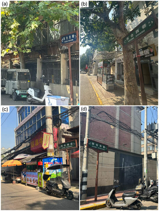
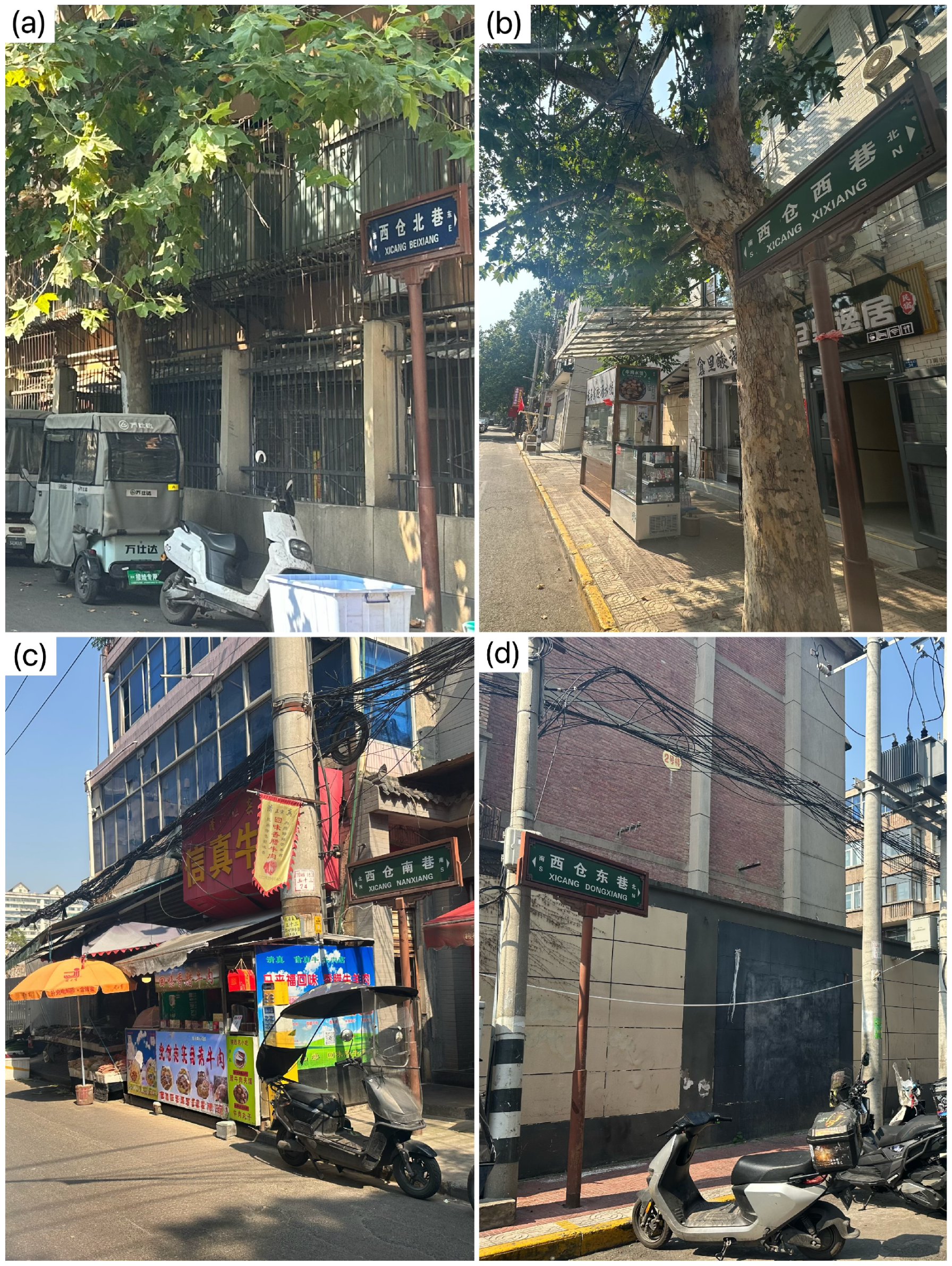
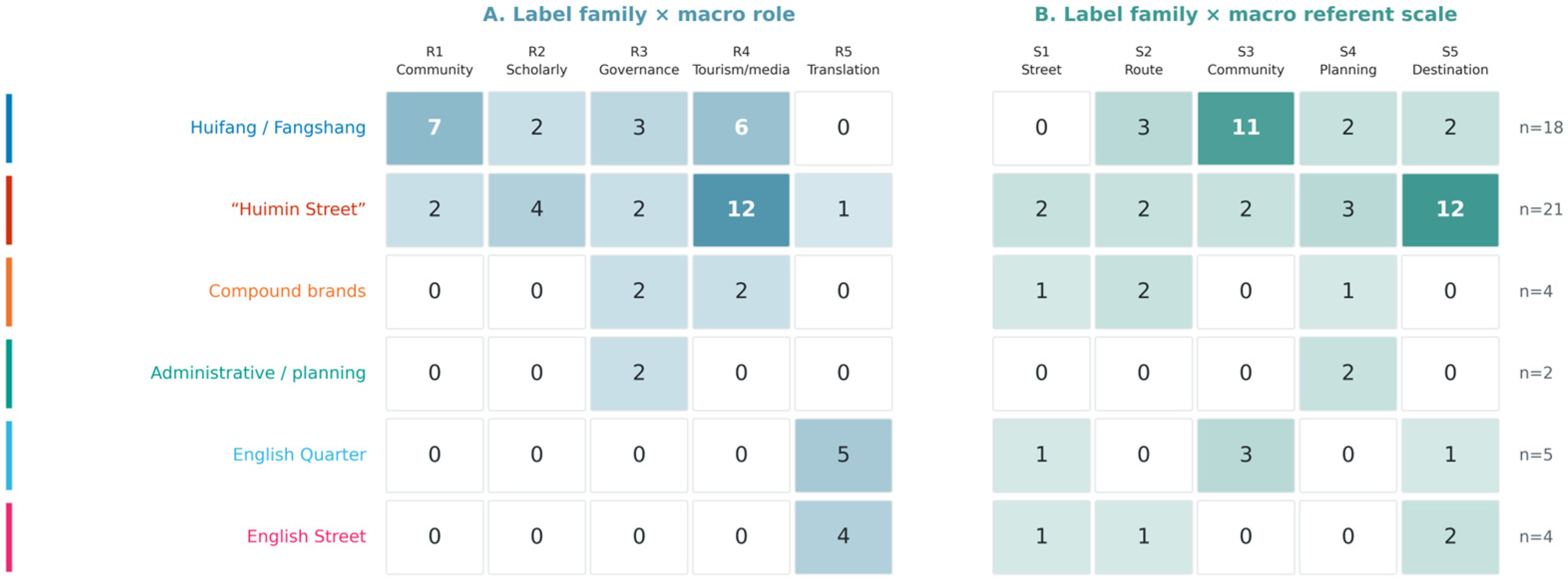
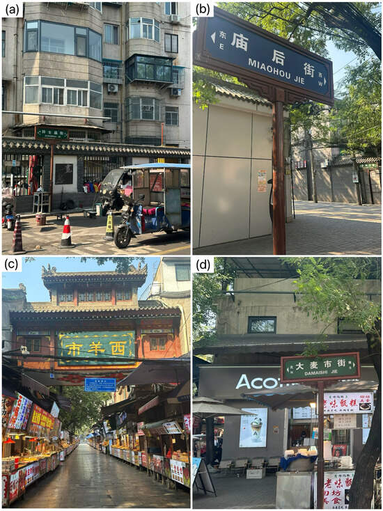
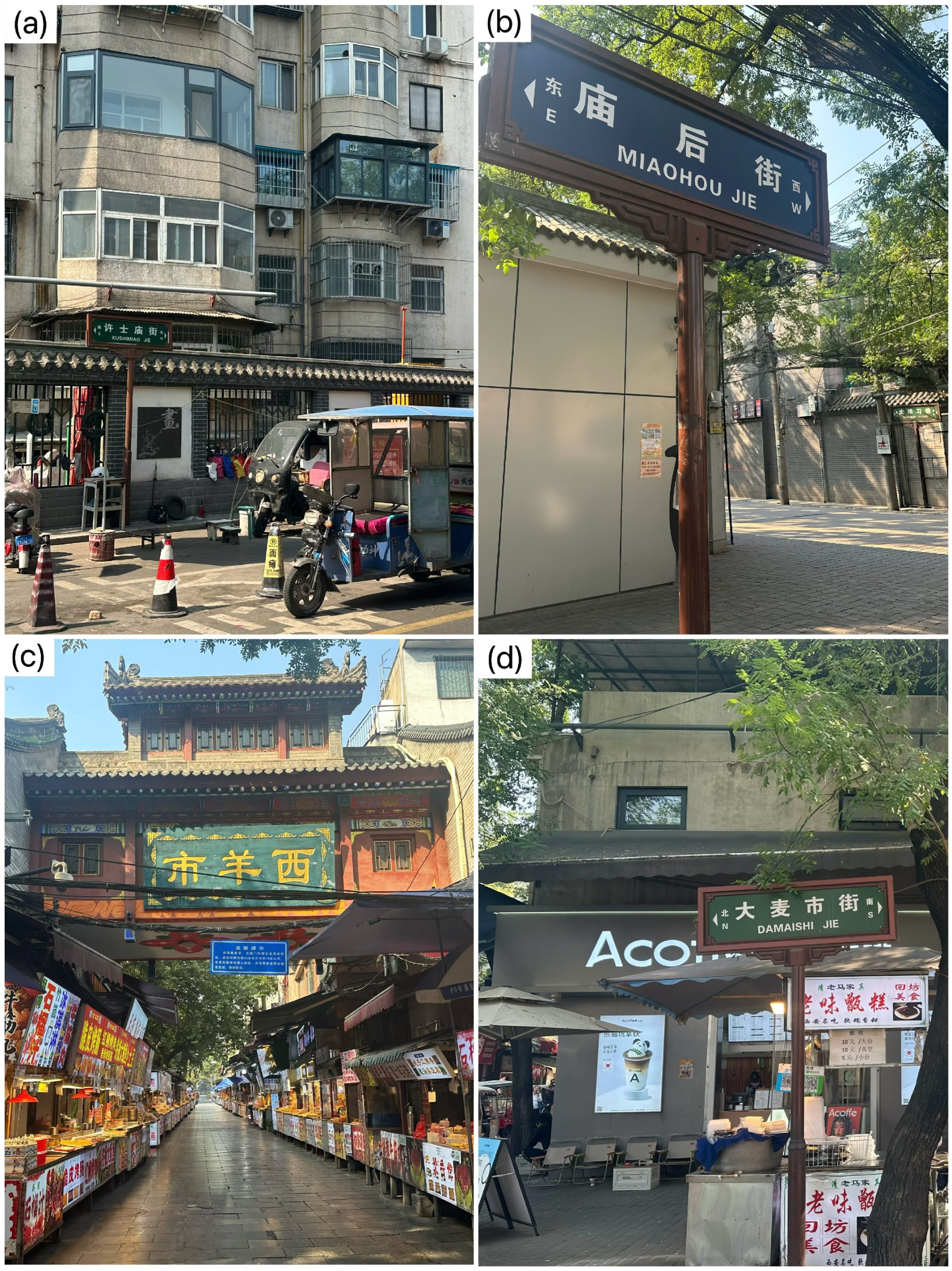
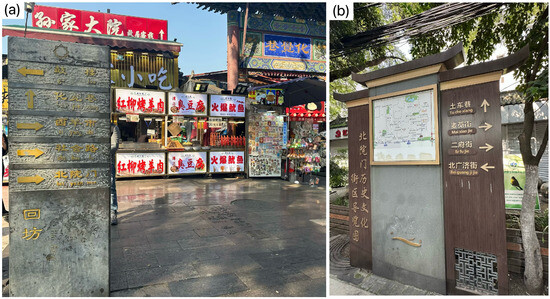
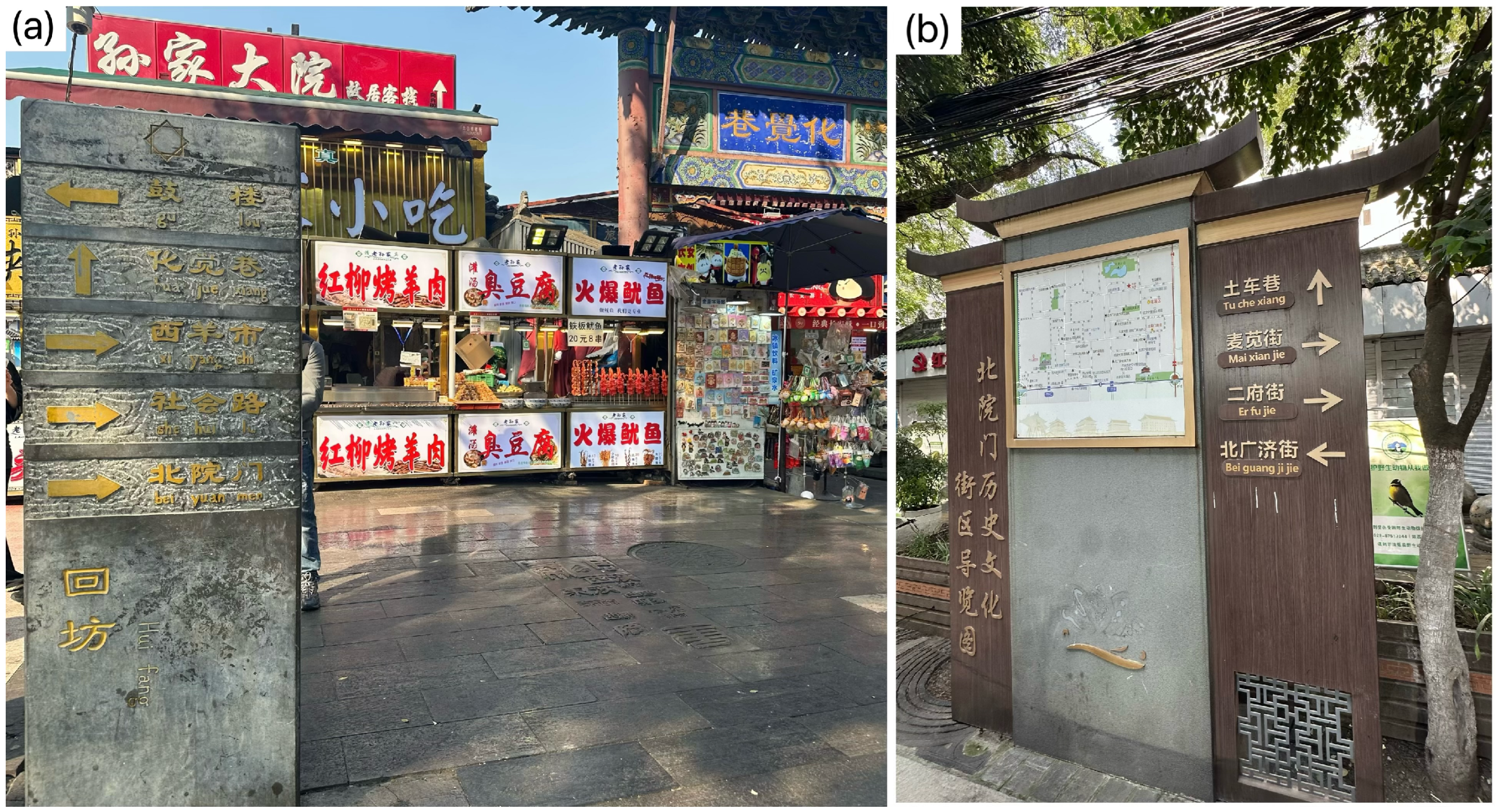

Disclaimer/Publisher’s Note: The statements, opinions and data contained in all publications are solely those of the individual author(s) and contributor(s) and not of MDPI and/or the editor(s). MDPI and/or the editor(s) disclaim responsibility for any injury to people or property resulting from any ideas, methods, instructions or products referred to in the content. |
© 2026 by the authors. Licensee MDPI, Basel, Switzerland. This article is an open access article distributed under the terms and conditions of the Creative Commons Attribution (CC BY) license.